
Notices to Mariners
May 31, 2024

Safety First, Service Always
Monthly Western Edition
CONTENTS
| Section 1 | General and Safety Information |
| Section 1A | Temporary and Preliminary Notices |
| Section 2 | Chart Corrections |
| Section 3 | Radio Aids to Marine Navigation Corrections |
| Section 4 | Canadian Sailing Directions Corrections |
| Section 5 | List of Lights, Buoys and Fog Signals Corrections |
Notices to Mariners – Monthly Western Edition
Edition No. 05/2024
Aussi disponible en français :
Avis aux navigateurs – Édition mensuelle de l’Ouest
Édition n° 05/2024
Published under the Authority of:
Canadian Coast Guard Programs
Aids to Navigation and Waterways
Fisheries and Oceans Canada
Montreal, QC H2Y 2E7
For more information, contact Notmar.XNCR@dfo-mpo.gc.ca.
© His Majesty the King in Right of Canada,
as represented by the Minister of Fisheries, Oceans
and the Canadian Coast Guard, 2024.
Cat. No. Fs152-9E-PDF (Electronic PDF, English)
ISSN 2817-0253
Cat. No. Fs152-9F-PDF (Electronic PDF, French)
ISSN 2817-0261

Explanatory Notes – Notices to Mariners (NOTMAR)
Geographical positions refer directly to the graduations of the largest scale Canadian Hydrographic Service chart (unless otherwise indicated).
Bearings refer to the true compass and are measured clockwise from 000° (North) clockwise to 359°; those relating to lights are from seaward.
Visibility of lights is that in clear weather.
Depths - The units used for soundings (metres, fathoms or feet) are stated in the title of each chart.
Elevations are normally given above Higher High Water, Large Tide (unless otherwise indicated).
Distances may be calculated as follows:
1 nautical mile = 1,852 metres (6,076.1 feet)
1 statute mile = 1,609.3 metres (5,280 feet)
1 metre = 3.28 feet
Temporary and Preliminary Notices to Mariners – Section 1A of Notices to Mariners
These notices are indicated by a (T) or a (P), respectively. Please note that nautical charts are not amended by the Canadian Hydrographic Service for temporary (T) and preliminary (P) notices. It is recommended that mariners chart these corrections in pencil. For the list of charts affected by (T) & (P) notices, please refer to the current Notices to Mariners - Monthly Summary of Temporary and Preliminary Notices publication.
Suggestions and Corrections Form
This form is specifically for suggestions and corrections to Notices to Mariners publications. It is available online and also in fillable PDF format included with the monthly publication ZIP file.
To submit comments and suggestions on possible improvements to the various publications and services: Notmar.XNCR@dfo-mpo.gc.ca.
To report chart discrepancies and/or corrections to the Canadian Sailing Directions booklets: Fill out the Marine Information Reporting Form and/or email chsinfo@dfo-mpo.gc.ca.
To report emergencies or navigational hazards: Contact your nearest MCTS centre
- VHF channel 16 (156.8 MHz)
- MF/HF frequency 2182 kHz/4125 kHz (where available)
- ∗16 on a cellphone (where available)
NOTMAR Website – Monthly Editions, Chart Corrections and Chart Patches
The NOTMAR website allows users to access the monthly publications,
chart corrections, and chart patches.
Users can subscribe for free to the email notification service
to receive notifications when charts of interest are updated, including their patches, as well as when a new Monthly Edition of Notices to Mariners is published.
In addition, the monthly publication and related
files to download, such as chart patches, can be obtained
all together through the download of a single ZIP file.
Explanatory Notes – Canadian Hydrographic Service (CHS)
Chart Corrections – Section 2 of Notices to Mariners
Corrections to nautical charts will be listed in numerical order by chart number. Each chart correction listed applies only to that particular chart. Related charts, if any, will have their own specific correction listed separately.
Users should also refer to CHS Chart 1: Symbols, Abbreviations and Terms for additional information pertaining to the correction of charts.
The illustration below describes the elements that will comprise a typical Section 2 chart correction:

The last correction number is identified with the LNM/D or Last Notice to Mariners Number / Date.
Mariners are advised that only the most critical changes that directly affect safety to navigation are issued in “Section 2 – Chart Corrections.” This limitation is required to ensure that charts remain as clear and easy to read as possible. As a result, mariners may see minor discrepancies of a non-critical nature between information in official publications. For example, a small change in the nominal range or focal height of a light may not result in the production of a chart correction in Notices to Mariners, but may result in a correction in the List of Lights, Buoys and Fog Signals publication.
Note: In the case of a discrepancy between information provided on CHS charts relating to aids to navigation, and the List of Lights, Buoys and Fog Signals publication, the latter shall be deemed as containing the most up-to-date information.
Canadian Nautical Charts & Publications
A source list of Canadian nautical charts and publications is published in Notice No. 14 of the Notices to Mariners Annual Edition 2024. The source supply and the prices effective at the time of printing are listed. For current chart edition dates, please refer to the following website: www.chs-shc.gc.ca/charts-cartes/paper-papier/index-eng.asp
Explanatory Notes – Marine Communications and Traffic Services (MCTS)
Navigational Warnings / Notices to Shipping
The Canadian Coast Guard (CCG) is implementing a number of changes to the aids to navigation system in Canada.
These changes are advertised as Navigational Warnings, formerly called Notices to ShippingFootnote 1, that are broadcast by the CCG, and are then followed up with Notices to Mariners, then charts are updated by hand correction, reprints or new editions.
Mariners are advised that all relevant Navigational Warnings (NAVWARN) should be kept until superseded by Notices to Mariners or through revised charts issued by the Canadian Hydrographic Service (CHS).
NAVWARN are accessible on the applicable regional page on the CCG Navigational Warnings website at http://nis.ccg-gcc.gc.ca.
CHS is reviewing the impact of these changes with CCG and together are preparing an action plan on the issuing of chart revisions.
For further information, contact your regional NAVWARN Issuing Desk.
Western Region
Prince Rupert MCTS Centre
Canadian Coast Guard
Bag 4444
Prince Rupert, BC V8J 4K2
Telephone: 250-627-3070
Email: NAVWARN.MCTSPrinceRupert@innav.gc.ca
Website: http://www.marinfo.gc.ca/e-nav
Arctic Region
* Iqaluit MCTS Centre
Operational from approximately mid-May until late December.
“A” Series NAVWARN
Canadian Coast Guard
P.O. Box 189
Iqaluit, NU X0A 0H0
Telephone: 867-979-5269
Facsimile: 867-979-4264
Email: NAVWARN.MCTSIqaluit@innav.gc.ca
* Service available in English and French.
Index
Numerical Index of Canadian Charts Affected
This numerical index lists all nautical charts mentioned in this monthly edition of Notices to Mariners. Only charts appearing in Section 2 of this publication require a chart correction. The appearance of charts in all other sections, particularly those related to the correction of other nautical publications, is included here for reference.
| 3000 | 3458 | 3490 | 3674 |
| 3002 | 3459 | 3491 | 3811 |
| 3057 | 3461 | 3526 | 6021 |
| 3062 | 3462 | 3527 | 6240 |
| 3419 | 3463 | 3564 | 6241 |
| 3440 | 3473 | 3601 | 6251 |
| 3441 | 3478 | 3606 | 6416 |
| 3442 | 3479 | 3668 | |
| 3443 | 3488 | 3670 | |
| 3456 | 3489 | 3671 |
SECTION 1 - GENERAL AND SAFETY INFORMATION
*505/23Canadian Hydrographic Service – Magnetic Declination Calculations
(Recurrent publication of notice *505/23, originally published in the Notices to Mariners – Monthly Western Edition 05/2023 publication.)
Mariners are advised that CHS has adopted the harmonized World Magnetic Model (WMM), as found on the NCEI/NOAA website. Old compass rose declination information on CHS navigational products can be updated using the Magnetic Declination Estimated Value website. While the differences in the model declinations are small each year, they can become more significant over a large period of time.
*1004/23Transport Canada – British Columbia North Coast Waterway Management Guidelines
(Recurrent publication of notice *1004/23, originally published in the Notices to Mariners – Monthly Western Edition 10/2023 publication.)
Reference: Notice *905/22 is cancelled.
The North Coast Waterway Management Guidelines are voluntary guidelines that aim to improve safety on the water by reducing conflicts between First Nations’ marine use activities, such as fishing and shoreline harvesting, and commercial vessels on the shipping route between Kitimat and Browning Entrance. The guidelines came into effect on September 1, 2022, and will be reviewed from time to time.
The guidelines apply to all vessels navigating on the route between Kitimat and Browning Entrance, on the north coast of British Columbia. This area includes:
|
•Douglas Channel |
•Otter Channel |
|
•Wright Sound |
•Nepean Sound, and |
|
•Lewis Passage |
•Principe Channel |

The complete guidelines document is available at the following link:
Nothing in these guidelines replaces or changes how we apply any Canadian or international laws or regulations, including the Collision Regulations. Furthermore, nothing in these guidelines prevents or limits the master or pilot of a ship from making any decisions to protect the vessel, the crew, or the marine environment.
The guidelines include information for:
•all vessels that covers:
-inshore safety zones
-routing measures
-speed reductions
-guidelines for meeting and passing
-a special operating area in Wright Sound, and
-guidelines in case of a mechanical or electrical
breakdown
•large commercial ships, including bulk carriers,
general cargo vessels, liquid bulk vessels, and passenger
vessels
•tugs and barges, and
•vessels operating in First Nations Areas of Concern where you must pay special attention to make sure local community users can transit and use the area safely.
*1207/23Canadian Hydrographic Service – Inappropriate Geographical Names Review Process
(Recurrent publication of notice *1207/23, originally published in the Notices to Mariners – Monthly Western Edition 12/2023 publication.)
The records of the Canadian Hydrographic Service could contain geographical names that may be considered inappropriate, offensive and derogatory. Geographical naming authorities are in the process of addressing many offensive place names, the review process is underway. For more information, about inappropriate geographical names, please see the following announcement.
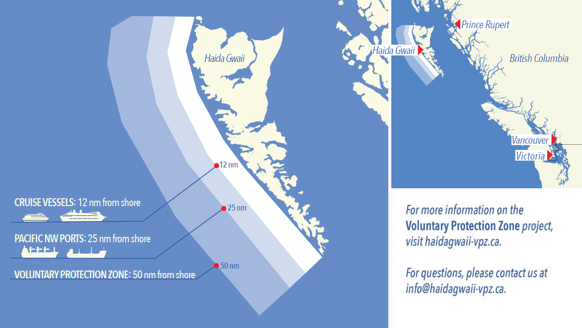
*208/24West Coast Haida Gwaii – Voluntary Protection Zone for Shipping
(Recurrent publication of notice *208/24, originally published in the Notices to Mariners – Monthly Western Edition 02/2024 publication.)
Reference: Notice *1105/21 is cancelled.
Voluntary Protection Zone for Shipping, western shore
of Haida Gwaii
(formerly Queen Charlotte Islands)
Haida Gwaii’s remote location, rugged coastline, variable sea and weather conditions, and rich ecological and cultural heritage make it vulnerable to the potential for pollution from shipping breakdowns and accidents. Increasing the distance vessels travel offshore can increase the amount of time available to address propulsion, steering or other issues, and the likelihood of a towing vessel being able to respond to a vessel in distress or drifting. This in turn reduces the risk of grounding and oil spills.
A Voluntary Protection Zone for Shipping on the western shore of Haida Gwaii is currently in effect. In the Voluntary Protection Zone, commercial vessels of 500 gross tonnage or greater are requested to observe a minimum distance of 50 nautical miles from the western shore of Haida Gwaii with the following exemptions:
Exemptions from requested 50 nm distance:
•Cruise vessels, which are asked to observe a minimum
12 nm distance from shore;
•Vessels transiting from Alaska to British Columbia or
Washington State, or vice versa, through the Voluntary
Protection Zone are asked to observe a distance of at least
25 nm from shore
•No minimum distance is requested for tugs and barges
(including pushing and towing alongside) or vessels engaged
in commercial fishing.
•Vessels to which this bulletin applies are not required to observe requested minimum distances if doing so may compromise navigational, vessel, passenger or cargo safety.
The Voluntary Protection Zone for Shipping coordinates are:
|
54⁰ 15.436' N |
133⁰ 04.788' W |
|
54⁰ 17.572' N |
134⁰ 02.484' W |
|
54⁰ 13.614' N |
134⁰ 19.427' W |
|
54⁰ 11.786' N |
134⁰ 30.841' W |
|
53⁰ 44.036' N |
134⁰ 32.677' W |
|
53⁰ 11.118' N |
134⁰ 16.412' W |
|
52⁰ 18.483' N |
133⁰ 20.917' W |
|
51⁰ 24.590' N |
132⁰ 04.081' W |
|
51⁰ 56.158' N |
131⁰ 01.830' W |
Vessels are requested to adhere to these distances on a voluntary basis and only when it does not jeopardize the safety of navigation, the vessel, the persons onboard, and the cargo.
*409/24Canadian Hydrographic Service – Chart 3811 Permanently Withdrawn
(Recurrent publication of notice *409/24, originally published in the Notices to Mariners – Monthly Western Edition 05/2024 publication.)
Chart 3811, Harbours in Queen Charlotte Islands/Havres dans Îles de la Reine-Charlotte, has been permanently cancelled.
*501/24Canadian Hydrographic Service – Electronic Navigational Charts
|
S-57 ENC Number |
Chart Title |
ENC Compilation Scale |
Published |
|
New Charts |
|||
|
CA448PMA (Edn 1.000) |
CA448PMA |
1:22 500 |
2024-05-10 |
|
CA448SCA (Edn 1.000) |
CA448SCA |
1:45 000 |
2024-05-24 |
|
CA448SNA (Edn 1.000) |
CA448SNA |
1:45 000 |
2024-05-24 |
|
CA448SYA (Edn 1.000) |
CA448SYA |
1:45 000 |
2024-05-24 |
|
CA448T9A (Edn 1.000) |
CA448T9A |
1:45 000 |
2024-05-24 |
|
CA448TKA (Edn 1.000) |
CA448TKA |
1:90 000 |
2024-05-24 |
|
CA44JPBA (Edn 1.000) |
CA44JPBA |
1:90 000 |
2024-05-10 |
|
CA44JPMA (Edn 1.000) |
CA44JPMA |
1:90 000 |
2024-05-10 |
|
CA44JPXA (Edn 1.000) |
CA44JPXA |
1:90 000 |
2024-05-10 |
|
CA44JQ8A (Edn 1.000) |
CA44JQ8A |
1:90 000 |
2024-05-10 |
|
CA44JQUB |
1:45 000 |
2024-05-10 |
|
|
CA44JR5A (Edn 1.000) |
CA44JR5A |
1:45 000 |
2024-05-10 |
|
CA44JRFA (Edn 1.000) |
CA44JRFA |
1:45 000 |
2024-05-24 |
|
CA44JS2A (Edn 1.000) |
CA44JS2A |
1:45 000 |
2024-05-24 |
|
CA44JS2B (Edn 1.000) |
CA44JS2B |
1:45 000 |
2024-05-24 |
|
CA44JSCA (Edn 1.000) |
CA44JSCA |
1:45 000 |
2024-05-24 |
|
CA44JSCB (Edn 1.000) |
CA44JSCB |
1:45 000 |
2024-05-24 |
|
CA44JSNA (Edn 1.000) |
CA44JSNA |
1:45 000 |
2024-05-24 |
|
CA44JSNB (Edn 1.000) |
CA44JSNB |
1:45 000 |
2024-05-24 |
|
CA44JSNC (Edn 1.000) |
CA44JSNC |
1:45 000 |
2024-05-24 |
|
CA44JSYA (Edn 1.000) |
CA44JSYA |
1:45 000 |
2024-05-24 |
|
CA44JSYB (Edn 1.000) |
CA44JSYB |
1:22 500 |
2024-05-17 |
|
CA44JSYC (Edn 1.000) |
CA44JSYC |
1:45 000 |
2024-05-24 |
|
CA44JSYD (Edn 1.000) |
CA44JSYD |
1:45 000 |
2024-05-24 |
|
CA44JT9A (Edn 1.000) |
CA44JT9A |
1:45 000 |
2024-05-24 |
|
CA44JT9B (Edn 1.000) |
CA44JT9B |
1:45 000 |
2024-05-24 |
|
CA44JT9C (Edn 1.000) |
CA44JT9C |
1:45 000 |
2024-05-24 |
|
CA44JTKA (Edn 1.000) |
CA44JTKA |
1:45 000 |
2024-05-24 |
|
CA44UPBA (Edn 1.000) |
CA44UPBA |
1:90 000 |
2024-05-10 |
|
CA44UPMB (Edn 1.000) |
CA44UPMB |
1:90 000 |
2024-05-10 |
|
CA44UPXB (Edn 1.000) |
CA44UPXB |
1:90 000 |
2024-05-10 |
|
CA44URRA (Edn 1.000) |
CA44URRA |
1:22 500 |
2024-05-10 |
|
CA44USYA (Edn 1.000) |
CA44USYA |
1:45 000 |
2024-05-24 |
|
CA44UT9A (Edn 1.000) |
CA44UT9A |
1:45 000 |
2024-05-24 |
|
CA44UT9B (Edn 1.000) |
CA44UT9B |
1:45 000 |
2024-05-24 |
|
CA44UT9C (Edn 1.000) |
CA44UT9C |
1:45 000 |
2024-05-24 |
|
CA44UT9D (Edn 1.000) |
CA44UT9D |
1:45 000 |
2024-05-24 |
|
CA44UTKA (Edn 1.000) |
CA44UTKA |
1:45 000 |
2024-05-24 |
|
CA455RRA (Edn 1.000) |
CA455RRA |
1:45 000 |
2024-05-10 |
|
CA455S2A (Edn 1.000) |
CA455S2A |
1:45 000 |
2024-05-10 |
|
CA455SCA (Edn 1.000) |
CA455SCA |
1:90 000 |
2024-05-10 |
|
CA455SNA (Edn 1.000) |
CA455SNA |
1:90 000 |
2024-05-10 |
|
CA455SNB (Edn 1.000) |
CA455SNB |
1:90 000 |
2024-05-10 |
|
CA455SNC (Edn 1.000) |
CA455SNC |
1:22 500 |
2024-05-10 |
|
CA455SYA (Edn 1.000) |
CA455SYA |
1:22 500 |
2024-05-10 |
|
CA455SYB (Edn 1.000) |
CA455SYB |
1:22 500 |
2024-05-10 |
|
CA455SYC (Edn 1.000) |
CA455SYC |
1:22 500 |
2024-05-10 |
|
CA455SYD (Edn 1.000) |
CA455SYD |
1:22 500 |
2024-05-10 |
|
CA455SYE |
1:22 500 |
2024-05-10 |
|
|
CA455T9A (Edn 1.000) |
CA455T9A |
1:90 000 |
2024-05-10 |
|
CA455TKA (Edn 1.000) |
CA455TKA |
1:90 000 |
2024-05-10 |
|
CA45FSCA (Edn 1.000) |
CA45FSCA |
1:90 000 |
2024-05-10 |
|
CA45FSNA (Edn 1.000) |
CA45FSNA |
1:90 000 |
2024-05-10 |
|
CA45FSYA (Edn 1.000) |
CA45FSYA |
1:90 000 |
2024-05-10 |
|
CA45FT9A (Edn 1.000) |
CA45FT9A |
1:90 000 |
2024-05-10 |
|
CA45FTKA (Edn 1.000) |
CA45FTKA |
1:90 000 |
2024-05-10 |
|
CA471206 (Edn 1.000) |
CA471206 |
1:22 500 |
2024-05-24 |
|
CA471207 (Edn 1.000) |
CA471207 |
1:90 000 |
2024-05-24 |
|
CA471208 (Edn 1.000) |
CA471208 |
1:45 000 |
2024-05-24 |
|
CA471210 (Edn 1.000) |
CA471210 |
1:90 000 |
2024-05-24 |
|
CA471219 (Edn 1.000) |
CA471219 |
1:45 000 |
2024-05-24 |
|
CA471220 (Edn 1.000) |
CA471220 |
1:22 500 |
2024-05-24 |
|
CA486EUA (Edn 1.000) |
CA486EUA |
1:90 000 |
2024-05-03 |
|
CA486F5A (Edn 1.000) |
CA486F5A |
1:90 000 |
2024-05-03 |
|
CA48GEUA (Edn 1.000) |
CA48GEUA |
1:90 000 |
2024-05-03 |
|
CA48GF5A (Edn 1.000) |
CA48GF5A |
1:90 000 |
2024-05-03 |
|
CA4AAAWA (Edn 1.000) |
Transit6600N10800W |
1:22 500 |
2024-05-03 |
|
CA4AAB7A (Edn 1.000) |
Transit6600N10900W |
1:22 500 |
2024-05-03 |
|
CA4AL9PA (Edn 1.000) |
Transit6700N11200W |
1:90 000 |
2024-05-03 |
|
CA4ALA0A (Edn 1.000) |
Transit6700N11100W |
1:90 000 |
2024-05-03 |
|
CA4ALAAA (Edn 1.000) |
Transit6700N11000W |
1:90 000 |
2024-05-03 |
|
CA4ALALA (Edn 1.000) |
Transit6700N10900W |
1:45 000 |
2024-05-03 |
|
CA4ALAWA (Edn 1.000) |
Transit6700N10800W |
1:45 000 |
2024-05-03 |
|
CA4AW9PA (Edn 1.000) |
Transit6800N11200W |
1:90 000 |
2024-05-03 |
|
CA4AWA0A (Edn 1.000) |
Transit6800N11100W |
1:90 000 |
2024-05-03 |
|
CA4AWAAA (Edn 1.000) |
Transit6800N11000W |
1:90 000 |
2024-05-03 |
|
CA4AWALA (Edn 1.000) |
Transit6800N10900W |
1:90 000 |
2024-05-03 |
|
CA4AWAWA (Edn 1.000) |
Transit6800N10800W |
1:90 000 |
2024-05-03 |
|
CA4B7AWA (Edn 1.000) |
Transit6900N10800W |
1:90 000 |
2024-05-03 |
|
CA55FSLA (Edn 1.000) |
CA55FSLA |
1:11 000 |
2024-05-10 |
|
CA55FSMA (Edn 1.000) |
CA55FSMA |
1:11 000 |
2024-05-10 |
|
New Editions |
|||
|
CA24URFB (Edn 2.000) |
CA24URFB |
1:175 000 |
2024-05-24 |
|
CA262SNA (Edn 2.000) |
CA262SNA |
1:350 000 |
2024-05-03 |
|
CA370203 (Edn 7.000) |
Approaches to/Approches à Juan de Fuca Strait |
1:75 000 |
2024-05-24 |
|
CA370208 (Edn 4.000) |
Ucluelet Inlet to/à Nootka Sound |
1:75 000 |
2024-05-24 |
|
West Point à/to Baie de Tracadie |
1:50 000 |
2024-05-17 |
|
|
CA376167 (Edn 9.000) |
Cape Smoky to St. Paul Island |
1:37 500 |
2024-05-17 |
|
CA376308 (Edn 3.000) |
Chéticamp to/à Cape St. Lawrence |
1:37 500 |
2024-05-17 |
|
CA376336 (Edn 4.000) |
Bonavista Bay, Western Portion/Partie ouest |
1:30 000 |
2024-05-17 |
|
CA46CS2A (Edn 2.000) |
CA46CS2A |
1:45 000 |
2024-05-03 |
|
CA470333 (Edn 6.000) |
Tofino Inlet to/à Millar Channel (Part 1 of 2) |
1:20 000 |
2024-05-24 |
|
CA470342 (Edn 6.000) |
Millar Channel to/à Estevan Point (Part 2 of 2) |
1:20 000 |
2024-05-24 |
|
CA54MQVA (Edn 3.000) |
Port4730N06190W |
1:4 000 |
2024-05-31 |
|
CA54NQVA (Edn 2.000) |
Port4740N06190W |
1:4 000 |
2024-05-31 |
|
CA576001 (Edn 14.000) |
Halifax Harbour - Bedford Basin |
1:5 000 |
2024-05-10 |
|
Charts Permanently Withdrawn |
|||
|
CA370016 |
Strait of Georgia, Northern Portion/Partie Nord |
Cancelled by CA471210,CA471208,CA471207 |
|
|
CA370381 |
Strait of Georgia, Central Portion/Partie Centrale (Part 1 of 2) |
Cancelled by CA471211,CA471208 |
|
|
CA373302 |
Bathurst Inlet - Southern Portion/Partie sud |
|
|
|
CA373336 |
Coronation Gulf Eastern Portion/Partie Est |
|
|
|
CA373337 |
Johansen Bay and/et Edinburgh Channel |
|
|
|
CA373349 |
Bathurst Inlet - Northern Portion/Partie nord |
|
|
|
CA373351 |
Bathurst Inlet - Central Portion/Partie Centrale |
|
|
|
CA376015 |
Motion Bay to/à Cape St Francis |
|
|
|
CA376070 |
Renews Harbour to/à Motion Bay |
|
|
|
CA376075 |
Bay Bulls to/à St. Mary's Bay |
|
|
|
CA376106 |
Cape Pine to/à Renews Harbour |
|
|
|
CA376120 |
Conception Bay |
|
|
|
CA376134 |
Neguac Bay (Continuation A) |
|
|
|
CA376135 |
Cape Pine to/au Cape St. Mary's |
|
|
|
CA376146 |
Cape St. Francis to/à Baccalieu Island and/et Heart's Content |
|
|
|
CA376153 |
Trinity Bay - Southern Portion/Partie Sud |
|
|
|
CA376164 |
Burin Peninsula to Saint-Pierre |
|
|
|
CA376166 |
Saint-Pierre and Miquelon (France) |
|
|
|
CA376173 |
Cape St. Mary's to Argentia Harbour and Jude Island |
|
|
|
CA376176 |
Long Island to St. Lawrence Harbours |
|
|
|
CA376187 |
Baie des Chaleurs / Chaleur Bay |
|
|
|
CA376233 |
Fortune Bay Southern Portion/Partie Sud |
|
|
|
CA376243 |
Trinity Bay - Northern Portion/Partie Nord |
|
|
|
Head of / Fond de St Mary's Bay |
|
||
|
CA376296 |
Cape St Mary's to/à Argentia |
|
|
|
CA376316 |
Fortune Bay Northern Portion/Partie Nord |
|
|
|
CA376336 |
Bonavista Bay, Western Portion/Partie ouest |
|
|
|
CA376337 |
Continuation A |
|
|
|
CA376339 |
Bonavista Bay, Southern Portion - Continuation A |
|
|
|
CA376340 |
Catalina Harbour to/à Inner Gooseberry Island |
|
|
|
CA376371 |
Indian Bay to/à Wadham Islands |
|
|
|
CA376616 |
Garia Bay to/à Burgeo |
|
|
|
CA376619 |
Burgeo to/à François |
|
|
|
CA376625 |
Cape Ray to/à Garia Bay |
|
|
|
CA376627 |
Hare Bay to/à Fortune Head |
|
|
|
CA376655 |
Cape Freels to/à Exploits Islands |
|
|
|
CA376656 |
White Bay and/et Notre Dame Bay |
|
|
|
CA376660 |
Cape St. John to/à St. Anthony |
|
|
|
CA376807 |
Bonavista Bay, Southern Portion |
|
|
|
CA376808 |
Bonavista Bay, Southern Portion |
|
|
|
CA470017 |
Discovery Passage |
|
|
|
CA470095 |
Jervis Inlet |
Cancelled by CA471208 |
|
|
CA470103 |
Desolation Sound and/et Sutil Channel |
Cancelled by CA471208,CA471207 |
|
|
CA470167 |
Alberni Inlet |
Cancelled by CA471220,CA471219,CA471210,CA471207 |
|
|
CA470218 |
Baynes Sound |
|
|
|
CA470334 |
Tofino Inlet to/à Millar Channel (Part 2 of 2) |
Cancelled by CA471206 |
|
|
CA470337 |
Barkley Sound (Part 1 of 2) |
Cancelled by CA471219,CA471207,CA471206 |
|
|
CA470338 |
Barkley Sound (Part 2 of 2) |
Cancelled by CA471219,CA471207 |
|
|
CA470725 |
Lasqueti Island |
Cancelled by CA471210,CA471208 |
|
|
CA470756 |
Halibut Bank to/à Ballenas Channel |
Cancelled by CA471210 |
|
|
CA476051 |
Smith Sound and/et Random Sound |
|
|
|
CA476079 |
Head of/Fond de Placentia Bay |
|
|
|
CA476080 |
Head of/Fond de Placentia Bay - Continuation A |
|
|
|
CA476081 |
Head of/Fond de Placentia Bay - Continuation B |
|
|
|
CA476085 |
Port Harmon and Approaches/et les approches |
|
|
|
CA476125 |
Miramichi |
|
|
|
Miramichi River - Chatham to/à Newcastle |
|
||
|
CA476133 |
Entrée à/Entrance to Miramichi River |
|
|
|
CA476168 |
Lewisporte and Approaches and Loon Bay |
|
|
|
CA476190 |
Bay of Islands |
|
|
|
CA476244 |
Trinity Harbour |
|
|
|
CA476279 |
Hamilton Sound, Eastern Portion / Partie est |
|
|
|
CA476294 |
St. Mary's Harbour and Adjacent Anchorages/et mouillages adjacents |
|
|
|
CA476300 |
Red Island to Pinchgut Point |
|
|
|
CA476323 |
Great Bay de l'Eau and Approaches/et les approches |
|
|
|
CA476479 |
Bay D'Espoir and/et Hermitage Bay |
|
|
|
CA476480 |
Hermitage Bay, Continuation |
Cancelled by CA44JSNA |
|
|
CA476520 |
Paradise Sound |
|
|
|
CA476622 |
Burgeo and/et Ramea Islands |
|
|
|
CA476639 |
Black Island to/à Little Denier Island |
|
|
|
CA476657 |
Botwood and Approaches/et les approches |
Cancelled by CA455SNC |
|
|
CA476658 |
Continuation A:Northerm Arm |
Cancelled by CA455SNC |
|
|
CA476708 |
Gregory Harbour to Rocky Harbour |
|
|
|
CA476719 |
Fogo Island Northern Portion |
|
|
|
CA476802 |
Bacalhao Island to Black Island |
|
|
|
CA476803 |
Bacalhao Island to Black Island |
Cancelled by CA455SYC |
|
|
CA476804 |
Bacalhao Island to Black Island |
|
|
|
CA476805 |
Presque Harbour to Bar Haven Island and Paradise Sound |
|
|
|
CA476806 |
Presque Harbour to Bar Haven Island and Paradise Sound |
|
|
|
CA476813 |
Carmanville to Bacalhoa Island and Fogo (Southern Portion) |
|
|
|
CA476814 |
Carmanville to Bacalhoa Island and Fogo (Northern Portion) |
|
|
*502/24Transport Canada - Ship Safety Bulletin #11/2024
A new Ship Safety Bulletin has recently been posted on the Transport Canada website.
To view or download this bulletin, please click on the link below:
SSB#11/2024 – New safe manning
webpage and revised application forms to obtain a safe
manning document (Updated in April
2024)
RDIMS#
20087849
Sign up for e-Bulletin to receive an e-mail notice each time a new Ship Safety Bulletin is published on our website.
Contact us at marinesafety-securitemaritime@tc.gc.ca or 1-855-859-3123 (Toll Free).
*503/24Canadian Coast Guard Publication - Amendments to the Notices to Mariners Annual Edition 2024 - Section A, Notice 5: General Guidelines for Aquatic Species at Risk and Important Marine Mammal Areas
Several amendments have been made throughout Notice 5, General Guidelines for Aquatic Species at Risk and Important Marine Mammal Areas.
The latest version of this notice is available on the Notices to Mariners website.
*504/24Canadian Coast Guard Publication - Amendments to the Notices to Mariners Annual Edition 2024 - Section A, Notice 5A: General Regulatory Requirements for all Oceans Act Marine Protected Areas
Several amendments have been made throughout Notice 5A, General Regulatory Requirements for all Oceans Act Marine Protected Areas from pages 25 to 33.
The latest version of this notice is available on the Notices to Mariners website.
*505/24Voluntary Avoidance of Anguniaqvia Niqiqyuam Marine Protected AreaS (ANMPA) and Tarium Niryutait Marine Protected Areas (TNMPA) and Voluntary Slowdown in Beluga and Bowhead Whale Areas
The two established Marine Protected Areas (MPAs) in Canada’s Western Arctic are located within the Inuvialuit Settlement Region, as such all activities must comply with the Inuvialuit Final Agreement. Protection and preservation of Arctic wildlife, the environment and biological productivity is one of the principles of the Inuvialuit Final Agreement and it is this principle that led the Inuvialuit Regional Corporation and the Inuvialuit Game Council to initiate establishment of the Western Arctic MPAs. The waters in and near the MPAs, and the offshore marine habitats of the Beaufort Sea and Amundsen Gulf, are important summer foraging habitats used seasonally (May-October) by the Eastern Beaufort Sea beluga stock, and the Bering-Chukchi-Beaufort bowhead population.
REGULATORY PROTECTION MEASURES
All whale species are protected under the Marine Mammal
Regulations, pursuant to the Fisheries Act. Within
the boundaries of the MPAs, a general prohibition is set out
in the Regulations, pursuant to the Oceans Act. Any
incident with a marine mammal within the MPAs must be
reported within two hours after its occurrence, to the
Canadian Coast Guard. For marine wildlife sightings and
incidents such as collisions that occur outside the MPAs or
for any situation involving a marine mammal that is dead or
in trouble, contact Fisheries and Oceans Canada, Inuvik
office at (867) 777-7500.
For more information on the ANMPA and TNMPA, including local
contacts and species specific minimum distances, see Section
A2 - Notices 5 and 5A of the Notices to Mariners Annual
Edition 2024.
Voluntary measures are in effect from June 1st to October 31st, 2024. See map above.
These measures apply to merchant vessels, cruise ships, small vessels and adventure craft within the boundaries of the MPAs and the additional identified areas to prevent collisions with whales and to mitigate the underwater noise generated by the vessels. These measures should only be taken when they will not jeopardize navigational safety.
Avoid (red area): To reduce the risk of
underwater noise disturbance and collisions with whales
within the MPAs, vessels should avoid transiting through the
MPAs if possible. If passage through this area is required,
vessels should slow down to a maximum of 10 knots over the
ground and post a lookout such as a marine mammal observer in
order to increase the chances of seeing the whales and thus
taking necessary measures to avoid them. If bypassing the
whales is not possible, slow down and wait for the animals to
move away to a distance greater than 400 metres (0.215
nautical miles) before resuming original speed up to 10 knots
over the ground. It is more difficult to see the animals in
rain, fog, or in rough sea states, therefore increased
caution is recommended.
Slow down to 10 knots over the ground or less (yellow
area): To reduce the risk of underwater noise
disturbance and collisions with whales within this area, it
is recommended that vessels should slow down to a maximum
speed of 10 knots over the ground, remain in the navigation
and marked community supply channels and post a
lookout.
These voluntary measures are secondary to rights under the
Inuvialuit Final Agreement.
MPA Coordinates
The Tarium Niryutait Marine Protected Areas consist of three areas of the Mackenzie Bay: Okeevik, Kittigaryuit and Niaqunnaq. The three areas are bounded by rhumb lines connecting the following geographical coordinates [North America Datum 1983 (NAD 83)/World Geodetic System (WGS 84)].
|
Okeevik Sub Area |
|
Kittigaryuit Sub Area |
|||||||
|
Point |
Latitude (North) |
Longitude (West) |
|
Point |
Latitude (North) |
Longitude (West) |
|||
|
1 |
69° 38’ 19” |
135° 25’ 09” |
|
1 |
69° 35’ 10” |
133° 48’ 26” |
|||
|
2 |
69° 38’ 03” |
135° 25’ 11” |
|
2 |
69° 34’ 00” |
133° 28’ 00” |
|||
|
3 |
69° 37’ 46” |
135° 24’ 52” |
|
3 |
69° 23’ 37” |
133° 26’ 40” |
|||
|
4 |
69° 29’ 49” |
135° 12’ 49” |
|
4 |
69° 20’ 34” |
133° 40’ 37” |
|||
|
5 |
69° 30’ 45” |
135° 16’ 56” |
|
5 |
69° 19’ 05” |
133° 42’ 21” |
|||
|
6 |
69° 29’ 26” |
135° 18’ 53” |
|
6 |
69° 19’ 01” |
133° 42’ 31” |
|||
|
7 |
69° 29’ 23” |
135° 19’ 06” |
|
7 |
69° 20’ 39” |
133° 43’ 20” |
|||
|
8 |
69° 28’ 07” |
135° 20’ 25” |
|
8 |
69° 16’ 42” |
133° 54’ 54” |
|||
|
9 |
69° 27’ 36” |
135° 24’ 25” |
|
9 |
69° 15’ 20” |
134° 06’ 53” |
|||
|
10 |
69° 25' 51” |
135° 32’ 27” |
|
10 |
69° 16’ 33” |
134° 05’ 56” |
|||
|
11 |
69° 26’ 32” |
135° 34’ 54” |
|
11 |
69° 20’ 42” |
134° 02’ 44” |
|||
|
12 |
69° 28’ 21” |
135° 35’ 24” |
|
12 |
69° 24’ 00” |
133° 59’ 10” |
|||
|
13 |
69° 28’ 35” |
135° 36’ 40” |
|
13 |
69° 24’ 34” |
133° 53’ 49” |
|||
|
14 |
69° 28’ 39” |
135° 37’ 58” |
|
14 |
69° 28’ 21” |
133° 48’ 15” |
|||
|
15 |
69° 30’ 34” |
135° 45’ 54” |
|
15 |
69° 28’ 02” |
133° 50’ 59” |
|||
|
16 |
69° 35’ 18” |
135° 35’ 42” |
|
16 |
69° 33’ 20” |
133° 47’ 29” |
|||
|
17 |
69° 36’ 00” |
135° 22’ 10” |
|
17 |
69° 34’ 33” |
133° 47’ 42” |
|||
|
18 |
69° 34’ 40” |
135° 20’ 09” |
|
18 |
69° 32’ 55” |
133° 51’ 09” |
|||
|
19 |
69° 34’ 00” |
135° 20’ 09” |
|
19 |
69° 32’ 56” |
133° 51’ 54” |
|||
|
20 |
69° 34’ 00” |
135° 27’ 39” |
|
20 |
69° 33’ 46” |
133° 55’ 48” |
|||
|
21 |
69° 36’ 00” |
135° 27’ 39” |
|
21 |
69° 33’ 46” |
133° 55’ 31” |
|||
|
22 |
69° 27’ 00” |
135° 31’ 11” |
|
|
|
|
|||
|
23 |
69° 27’ 00” |
135° 34’ 45” |
|
|
|
|
|||
|
Point |
Latitude (North) |
Longitude (West) |
|||||||
|
1 |
69° 08’ 00” |
136° 16’ 44” |
|||||||
|
2 |
69° 04’ 25” |
136° 07’ 45” |
|||||||
|
3 |
69° 03’ 43” |
136° 07’ 08” |
|||||||
|
4 |
69° 01’ 19” |
136° 04’ 45” |
|||||||
|
5 |
69° 01’ 14” |
136° 04’ 45” |
|||||||
|
6 |
69° 00’ 57” |
136° 05’ 42” |
|||||||
|
7 |
69° 00’ 12” |
136° 07’ 08” |
|||||||
|
8 |
68° 57’ 00” |
136° 10’ 00” |
|||||||
|
9 |
68° 55’ 00” |
136° 15’ 00” |
|||||||
|
10 |
68° 54’ 22” |
136° 31’ 50” |
|||||||
|
11 |
68° 55’ 00” |
136° 38’ 33” |
|||||||
|
12 |
68° 56’ 15” |
137° 00’ 41” |
|||||||
|
13 |
68° 56’ 29” |
137° 03’ 03” |
|||||||
|
14 |
68° 55’ 48” |
137° 11’ 00” |
|||||||
|
15 |
68° 57’ 50” |
137° 16’ 40” |
|||||||
|
16 |
68° 59’ 20” |
137° 21’ 30” |
|||||||
|
17 |
69° 03’ 09” |
137° 44’ 54” |
|||||||
The Anguniaqvia niqiqyuam Marine Protected Areas consist of two areas in Darnley Bay and Amundsen Gulf in the Beaufort Sea: Zone 1 and Zone 2. The areas consist of the seabed, the subsoil to a depth of five metres and the water column, including the sea ice. The two areas are bounded by straight lines connecting the following geographical coordinates [North America Datum 1983 (NAD 83)].
|
Zone 1 |
||
|
Point |
Latitude (North) |
Longitude (West) |
|
A |
69° 21’ 07.8” |
124° 21’ 32.0” approx |
|
B |
70° 12’ 00.0” approx |
124° 31’ 55.2” |
|
C |
70° 08’ 22.0” |
124° 41’ 45.0” approx |
|
D |
70° 09’ 09.9” |
124° 57’ 42.0” approx |
|
E |
70° 09’ 13.0” approx |
125° 05’ 28.6” |
|
F |
70° 09’ 13.2” |
125° 17’ 53.0” |
|
G |
70° 20’ 00.0” |
125° 17’ 53.0” |
|
H |
70° 20’ 00.0” |
123° 54’ 17.5” |
|
I |
69° 37’ 20.6” |
123° 54’ 17.5” |
|
J |
69° 30’ 00.0” |
124° 15’ 34.7” |
|
|
||
|
|
||
|
Point |
Latitude (North) |
Longitude (West) |
|
K |
70° 04’ 15.8” |
124° 41’ 51.0” approx |
|
L |
70° 04’ 48.6” |
124° 41’ 54.0” approx |
|
M |
70° 02’ 12.9” |
124° 35’ 23.0” approx |
|
N |
70° 02’ 12.9” |
124° 35’ 29.0” approx |
*511/24Millhaven Bay – Bennet Lake – Unlit Buoy Permanently Discontinued
Reference chart: N/A
The following unlit buoy has been permanently discontinued:
|
Aid Name |
LL # |
Position |
|
Wedge Rock buoy Y43 |
6515 |
60° 05’ 11.2”N 134° 56’ 23.9”W |
(P2024-034)
Reminder – Comment Period for Active Preliminary Notices
No notices applicable for this edition.
Inland Waters
Temporary Notices
No notices applicable for this edition.
Preliminary Notices
No notices applicable for this edition.
Pacific Coast
Temporary Notices
No notices applicable for this edition.
Preliminary Notices
|
Comment
Submission |
Comments should be directed to the following: |
*514(P)/24Fraser River/Fleuve Fraser, Crescent Island to/à Harrison Mills – Unlit Buoy to be Discontinued
Reference chart: 3488
The Canadian Coast Guard proposes to permanently discontinue the following aid to navigation:
|
Aid Name |
LL # |
Position |
|
Crescent Island buoy S60 |
5238 |
49° 09’ 33.2”N 122° 24’ 45.7”W |
Initial publication date: Friday, May 31st, 2024
Comment submission
deadline: Thursday, August 29, 2024
(P2024-027)
*515(P)/24Fraser River/Fleuve Fraser, Sand Heads to/à Douglas Island – Unlit Buoy to be Discontinued
Reference chart: 3490
The Canadian Coast Guard proposes to permanently discontinue the following aid to navigation:
|
Aid Name |
LL # |
Position |
|
Fraser River buoy S38 |
5237 |
49° 12’ 35.4”N 122° 53’ 24.7”W |
Initial publication date: Friday, May 31st, 2024
Comment submission
deadline: Thursday, August 29, 2024
(P2024-026)
SECTION 2 - CHART CORRECTIONS
3000 - Juan de Fuca Strait to/à Dixon Entrance - New Edition - 20-JAN-1989 - NAD 1927
ZONE DE PROTECTION VOLONTAIRE Une zone de protection volontaire pour la navigation est en vigueur sur la côte ouest de Haida Gwaii. Dans cette zone, les navires commerciaux de 500 tonnes brutes ou plus doivent observer une distance minimale de 50 milles marins de la côte lorsqu’ils transitent, à quelques exceptions. Pour en savoir plus, consultez l’Avis aux navigateurs mensuel ou le site web haidagwaii-vpz.ca.
(See Chart 1, A14)
ZONE DE PROTECTION VOLONTAIRE Une zone de protection volontaire pour le transport maritime sur la rive ouest de Haida Gwaii est en vigueur depuis le 1er septembre 2020. Dans la zone de protection volontaire, on demande aux bâtiments commerciaux d’une jauge brute de 500 ou plus de respecter une distance minimale de 50 milles marins de la rive ouest de la côte ouest de Haida Gwaii, avec quelques exemptions. Pour de plus amples renseignements, visitez haidagwaii vpz.ca ou consultez l’avis aux navigateurs.
(See Chart 1, A14)
3002 - Queen Charlotte Sound to/à Dixon Entrance - New Edition - 16-DEC-1994 - NAD 1927
ZONE DE PROTECTION VOLONTAIRE Une zone de protection volontaire pour la navigation est en vigueur sur la côte ouest de Haida Gwaii. Dans cette zone, les navires commerciaux de 500 tonnes brutes ou plus doivent observer une distance minimale de 50 milles marins de la côte lorsqu’ils transitent, à quelques exceptions. Pour en savoir plus, consultez l’Avis aux navigateurs mensuel ou le site web haidagwaii-vpz.ca.
(See Chart 1, A14)
ZONE DE PROTECTION VOLONTAIRE Une zone de protection volontaire pour le transport maritime sur la rive ouest de Haida Gwaii est en vigueur depuis le 1er septembre 2020. Dans la zone de protection volontaire, on demande aux bâtiments commerciaux d’une jauge brute de 500 ou plus de respecter une distance minimale de 50 milles marins de la rive ouest de la côte ouest de Haida Gwaii, avec quelques exemptions. Pour de plus amples renseignements, visitez haidagwaii vpz.ca ou consultez l’avis aux navigateurs.
(See Chart 1, A14)
3062 - Pitt River - Sheet/Feuille 1 - New Chart - 24-MAY-1985 - NAD 1927
(See Chart 1, I10)
3419 - Esquimalt Harbour - New Edition - 13-DEC-2013 - World Geodetic System 1984
(See Chart 1, F23)
and 48°25′54.2″N 123°25′49.6″W
(See Chart 1, F22)
(See Chart 1, F22)
(See Chart 1, F22)
(See Chart 1, F22)
(See Chart 1, F22)
(See Chart 1, F22)
(See Chart 1, F22)
(See Chart 1, F22)
(See Chart 1, F16)
48°25′52.8″N 123°25′39.0″W
48°25′52.9″N 123°25′39.2″W
48°25′52.8″N 123°25′39.4″W
and 48°25′52.7″N 123°25′39.2″W
(See Chart 1, F16)
48°25′52.7″N 123°25′39.0″W
48°25′52.8″N 123°25′39.0″W
48°25′52.9″N 123°25′39.1″W
48°25′52.8″N 123°25′39.2″W
48°25′53.5″N 123°25′40.0″W
48°25′53.6″N 123°25′39.9″W
48°25′57.5″N 123°25′44.4″W
48°25′57.4″N 123°25′44.6″W
48°25′57.3″N 123°25′44.7″W
48°25′53.5″N 123°25′40.2″W
48°25′53.5″N 123°25′40.1″W
48°25′52.8″N 123°25′39.3″W
48°25′52.7″N 123°25′39.3″W
48°25′52.6″N 123°25′39.2″W
48°25′52.6″N 123°25′39.1″W
and 48°25′52.5″N 123°25′38.7″W
3442 - North Pender Island to/à Thetis Island - New Edition - 01-JUL-2005 - NAD 1983
(See Chart 1, Qp)
(See Chart 1, Qp)
(See Chart 1, S4)
(See Chart 1, S4)
(See Chart 1, S4)
(See Chart 1, P16)
(See Chart 1, S4)
(See Chart 1, S4)
3443 - Thetis Island to/à Nanaimo - New Edition - 20-DEC-2002 - NAD 1983
(See Chart 1, Qp)
(See Chart 1, Qp)
(See Chart 1, Q58)
3456 - Halibut Bank to/à Ballenas Channel - New Chart - 01-JUL-2011 - NAD 1983
(See Chart 1, Q58)
3458 - Approaches to/Approches à Nanaimo Harbour - New Edition - 10-MAR-1995 - NAD 1983
(See Chart 1, Q58)
3459 - Approaches to/Approches à Nanoose Harbour - New Edition - 24-OCT-1997 - NAD 1983
(See Chart 1, I10)
(See Chart 1, I10)
(See Chart 1, I10)
(See Chart 1, I10)
(See Chart 1, K11)
3461 - Juan de Fuca Strait, Eastern Portion/Partie Est - New Edition - 01-JUL-2005 - NAD 1983
(See Chart 1, S3.6)
3462 - Juan de Fuca Strait to/à Strait of Georgia - New Edition - 01-JUL-2005 - NAD 1983
(See Chart 1, S4)
(See Chart 1, S4)
(See Chart 1, S4)
(See Chart 1, P16)
(See Chart 1, S4)
3463 - Strait of Georgia, Southern Portion/Partie Sud - New Edition - 01-JUL-2005 - NAD 1983
(See Chart 1, S4)
(See Chart 1, S4)
(See Chart 1, P16)
(See Chart 1, S4)
3473 - Active Pass - New Edition - 10-JAN-2020 - World Geodetic System 1984
(See Chart 1, S4)
3473 - Montague Harbour - New Edition - 10-JAN-2020 - World Geodetic System 1984
(See Chart 1, P16)
3478 - Ganges Harbour and/et Long Harbour - New Edition - 12-JUL-2013 - NAD 1983
(See Chart 1, S4)
(See Chart 1, S4)
(See Chart 1, S4)
(See Chart 1, S4)
3479 - Approaches to/Approches à Sidney - New Chart - 18-MAY-2007 - NAD 1983
(See Chart 1, S4)
3489 - Pattullo Bridge to/à Barnston Island - Sheet/Feuille 1 - New Chart - 21-OCT-1994 - NAD 1983
(See Chart 1, I10)
3490 - Fraser River/Fleuve Fraser, Sand Heads to/à Douglas Island, Compartment A-B - New Edition - 02-NOV-2012 - World Geodetic System 1984
(See Chart 1, P16)
(See Chart 1, P16)
3490 - Fraser River/Fleuve Fraser, Sand Heads to/à Douglas Island, Compartment B-C - New Edition - 02-NOV-2012 - World Geodetic System 1984
(See Chart 1, P16)
(See Chart 1, P16)
(See Chart 1, K40)
(See Chart 1, L41.1)
49°09′31.0″N 122°56′51.4″W
and 49°09′33.7″N 122°56′46.1″W
(See Chart 1, L41.1)
and 49°09′28.9″N 122°56′57.1″W
3491 - Compartment B-C - New Edition - 19-OCT-2012 - World Geodetic System 1984
(See Chart 1, K40)
(See Chart 1, L41.1)
49°09′31.0″N 122°56′51.4″W
and 49°09′33.7″N 122°56′46.1″W
(See Chart 1, L41.1)
and 49°09′28.9″N 122°56′57.1″W
3526 - Howe Sound - New Edition - 01-JUL-2005 - NAD 1983
(See Chart 1, Qp)
(See Chart 1, Qp)
(See Chart 1, Qp)
(See Chart 1, Qp)
3527 - Baynes Sound - New Edition - 06-APR-2001 - NAD 1983
(See Chart 1, K48.2)
(See Chart 1, K48.2)
3601 - Juan de Fuca Strait to/à Vancouver Harbour - New Edition - 01-JUL-2005 - NAD 1983
(See Chart 1, S3.6)
3606 - Juan de Fuca Strait - New Edition - 29-NOV-2002 - NAD 1983
(See Chart 1, Q58)
3670 - Broken Group - New Edition - 21-OCT-1994 - NAD 1983
(See Chart 1, I10)
(See Chart 1, I10)
(See Chart 1, I10)
(See Chart 1, I10)
(See Chart 1, I10)
(See Chart 1, I10)
(See Chart 1, I10)
(See Chart 1, I10)
(See Chart 1, I10)
(See Chart 1, I10)
(See Chart 1, I10)
(See Chart 1, I10)
(See Chart 1, I10)
(See Chart 1, I10)
(See Chart 1, I10)
(See Chart 1, I10)
(See Chart 1, I10)
(See Chart 1, I10)
(See Chart 1, I10)
(See Chart 1, I10)
(See Chart 1, I10)
(See Chart 1, I10)
(See Chart 1, I10)
(See Chart 1, K11)
(See Chart 1, I10)
3671 - Barkley Sound - New Edition - 04-NOV-2005 - NAD 1983
(See Chart 1, I10)
(See Chart 1, I10)
(See Chart 1, I10)
(See Chart 1, I10)
(See Chart 1, I10)
(See Chart 1, I10)
(See Chart 1, I10)
(See Chart 1, I10)
(See Chart 1, I10)
(See Chart 1, I10)
(See Chart 1, N62.2)
3674 - Marktosis - New Chart - 01-DEC-1995 - NAD 1983
(See Chart 1, I10)
(See Chart 1, I10)
(See Chart 1, I10)
(See Chart 1, I10)
(See Chart 1, I10)
(See Chart 1, I10)
(See Chart 1, I10)
(See Chart 1, I10)
(See Chart 1, I10)
(See Chart 1, K12)
(See Chart 1, I10)
(See Chart 1, K11)
(See Chart 1, K11)
6021 - Lake Muskoka - Sheet/Feuille 1 - New Edition - 30-JUL-2004 - NAD 1983
(See Chart 1, Qb)
(See Chart 1, Qc)
(See Chart 1, Qc)
(See Chart 1, Qb)
6240 - Red River / Rivière Rouge to/à Berens River - Sheet/Feuille 1 - New Edition - 16-JUL-2004 - Unknown
(See Chart 1, P1)
(See Chart 1, P1)
6241 - Berens River to/à Nelson River - Sheet/Feuille 1 - New Edition - 27-MAY-2005 - Unknown
(See Chart 1, P1, S4)
(See Chart 1, P1, S4)
6251 - Red River / Rivière Rouge to/à Gull Harbour - Sheet/Feuille 1 - New Edition - 26-MAY-2000 - NAD 1927
(See Chart 1, P1)
(See Chart 1, P1)
6416 - Saline Island to/à Police Island Kilometre 730 / Kilomètre 810 - New Edition - 25-JAN-2008 - NAD 1983
(See Chart 1, I10)
(See Chart 1, Qc)
to 64°31′17.8″N 124°56′36.1″W
SECTION 3 - RADIO AIDS TO MARINE NAVIGATION CORRECTIONS
No corrections for this section.
SECTION 4 - CANADIAN SAILING DIRECTIONS CORRECTIONS
The following Canadian Sailing Directions volumes have recently been updated on the Canadian Hydrographic Service website.
|
No. |
Title |
|
Atlantic Coast |
|
|
ATL 104 |
Cape North to Cape Canso (including Bras d’Or Lake) |
|
ATL 105 |
Cape Canso to Cape Sable (including Sable Island) |
|
Central Canada |
|
|
CEN 302 |
Lake Ontario |
|
CEN 305 |
Lake Huron, St. Marys River, Lake Superior |
|
CEN 308 |
Rideau Canal and Ottawa River |
Each volume includes a section entitled “Record of Changes” which lists all updates that are incorporated during the current calendar year.
SECTION 5 - LIST OF LIGHTS, BUOYS AND FOG SIGNALS CORRECTIONS
The amendments are highlighted and deletions are crossed out. For general and region-specific
information on the List of Lights, click on the following links:
Newfoundland and Labrador Coast,
Atlantic Coast,
Inland Waters and
Pacific Coast.
PACIFIC COAST
| No. | Name |
Position ----- Latitude N. Longitude W. |
Light Characteristics |
Focal Height in m. above water |
Nominal Range |
Description ----- Height in meters above ground |
Remarks ----- Fog Signals |
|||
|---|---|---|---|---|---|---|---|---|---|---|
UPPER AND LOWER ARROW LAKE – COLUMBIA RIVER (LL 26 – 41) |
||||||||||
| 33 | Burton West |
W. side of channel. 49 59 27.2 117 54 24.1 |
Fl |
W R |
4s | 16.0 | 4 | Square skeleton tower, white rectangular daymark. |
Red from 178° to 180°18'; white from 180°18' to 24°27'. Year round. Chart:3057 Edn 05/24 (P24-022) |
|
WEST COAST, VANCOUVER ISLAND (LL 66 – 179.1) |
||||||||||
|
167 G5275.8 |
Maritime Discovery Centre |
Delete from
list. Chart:3668 Edn 05/24 |
||||||||
HARO STRAIT (LL 222.8 – 265) |
||||||||||
| 222.8 | Little Zero Rock light buoy V30 |
W. of 48 31 54.3 123 19 47.6 |
Q | R | 1s | ….. | ….. | Red, marked “V30”. |
Year round. Chart:3440 Edn 05/24 (P24-032) |
|
| 255.1 | Haro Strait light Junction buoy (U.S.) A |
SW. of Danger Shoal. 48 38 18.2 123 11 01.2 |
Fl (2+1) | G | 6s | ….. | ….. | Green, red and green, marked “A”. |
Year round. Chart:3441 Edn 05/24 (P24-023) |
|
FRASER RIVER – SOUTH ARM (LL 310 – 371) |
||||||||||
|
361 362G5413.36 G5413.37 |
City Reach Inbound range |
| | | | | | | | | | | | |
On S. bank of river. 095°17’
219.9 m49 09 17.9 122 56 41.0 from front. |
Oc
Oc(2)
|
Y
Y
|
5s
5s
|
13.8
25.1
|
15
15
|
Pipe
tower, red daymark with white vertical
stripe.
Pipe
tower, red daymark with white vertical
stripe.
|
Flash 4.7 s;
eclipse 0.3 s. Flash 3.7 s;
eclipse 0.3 s;Visible in line of range. Operates 24 h. Year round. flash 0.7 s; eclipse 0.3 s. Visible in line of range. Operates 24 h. Year round. Chart:3490 Edn 05/24 (P24-030, 031) |
NORTHERN STRAIT OF GEORGIA (LL 447.5 – 510) |
||||||||||
|
501 502G5542 G5542.1 |
Comox Bar range |
| | | | | | | | | |
On the W. shore of Baynes Sound. 222°05’
284.8 m from front.
49 37 23.1 124 54 31.9 |
Iso
Iso
|
Y
Y
|
1.5s
2s
|
7.9
19.7
|
17
17
|
Square skeleton tower, white daymark with red vertical
stripe.
Square skeleton tower, white daymark with red vertical
stripe.
|
Flash 0.75 s;
eclipse 0.75 s. Operates 24
h.Operates 24 h. Year round. Year round. Chart:3527 Edn 05/24 (P24-024, 025) |
JOHNSTONE STRAIT (LL 518 – 544.6) |
||||||||||
|
538 539G5616 G5616.1 |
Ray Point range |
| | | | | | | | | |
On the point. 087°48’ 23.1 m50 34 49.0 126 12 00.8 from front. |
F
F
|
Y
Y
|
….
….
|
7.8
11.8
|
5
5
|
Square skeleton tower, red daymark with white vertical
stripe. Square skeleton tower, red daymark with white vertical
stripe.
|
Year round.
Year round.Chart:3564 Edn 05/24 (P24-029) |
|
540 541G5617 G5617.1 |
East Cracroft Island range |
| | | | | | | | |
On northeastern side of island. 270°55’ 27.3 m50 34 47.0 126 14 28.1 from front. |
F
F
|
Y
Y
|
….
….
|
5.6
13.7
|
5
5
|
Square skeleton tower, red daymark with white vertical
stripe.
Square skeleton tower, red daymark with white vertical
stripe.
|
Year round.
Year round.Chart:3564 Edn 05/24 (P24-028) |
Report a problem on this page
- Date modified: