

Notices to Mariners
March 29, 2024

Safety First, Service Always
Monthly Western Edition
CONTENTS
| Section 1 | General and Safety Information |
| Section 1A | Temporary and Preliminary Notices |
| Section 2 | Chart Corrections |
| Section 3 | Radio Aids to Marine Navigation Corrections |
| Section 4 | Canadian Sailing Directions Corrections |
| Section 5 | List of Lights, Buoys and Fog Signals Corrections |
Notices to Mariners – Monthly Western Edition
Edition No. 03/2024
Aussi disponible en français :
Avis aux navigateurs – Édition mensuelle de l’Ouest
Édition n° 03/2024
Published under the Authority of:
Canadian Coast Guard Programs
Aids to Navigation and Waterways
Fisheries and Oceans Canada
Montreal, QC H2Y 2E7
For more information, contact Notmar.XNCR@dfo-mpo.gc.ca.
© His Majesty the King in Right of Canada,
as represented by the Minister of Fisheries, Oceans
and the Canadian Coast Guard, 2024.
Cat. No. Fs152-9E-PDF (Electronic PDF, English)
ISSN 2817-0253
Cat. No. Fs152-9F-PDF (Electronic PDF, French)
ISSN 2817-0261

Explanatory Notes – Notices to Mariners (NOTMAR)
Geographical positions refer directly to the graduations of the largest scale Canadian Hydrographic Service chart (unless otherwise indicated).
Bearings refer to the true compass and are measured clockwise from 000° (North) clockwise to 359°; those relating to lights are from seaward.
Visibility of lights is that in clear weather.
Depths - The units used for soundings (metres, fathoms or feet) are stated in the title of each chart.
Elevations are normally given above Higher High Water, Large Tide (unless otherwise indicated).
Distances may be calculated as follows:
1 nautical mile = 1,852 metres (6,076.1 feet)
1 statute mile = 1,609.3 metres (5,280 feet)
1 metre = 3.28 feet
Temporary and Preliminary Notices to Mariners – Section 1A of Notices to Mariners
These notices are indicated by a (T) or a (P), respectively. Please note that nautical charts are not amended by the Canadian Hydrographic Service for temporary (T) and preliminary (P) notices. It is recommended that mariners chart these corrections in pencil. For the list of charts affected by (T) & (P) notices, please refer to the current Notices to Mariners - Monthly Summary of Temporary and Preliminary Notices publication.
Suggestions and Corrections Form
This form is specifically for suggestions and corrections to Notices to Mariners publications. It is available online and also in fillable PDF format included with the monthly publication ZIP file.
To submit comments and suggestions on possible improvements to the various publications and services: Notmar.XNCR@dfo-mpo.gc.ca.
To report chart discrepancies and/or corrections to the Canadian Sailing Directions booklets: Fill out the Marine Information Reporting Form and/or email chsinfo@dfo-mpo.gc.ca.
To report emergencies or navigational hazards: Contact your nearest MCTS centre
- VHF channel 16 (156.8 MHz)
- MF/HF frequency 2182 kHz/4125 kHz (where available)
- ∗16 on a cellphone (where available)
NOTMAR Website – Monthly Editions, Chart Corrections and Chart Patches
The NOTMAR website allows users to access the monthly publications,
chart corrections, and chart patches.
Users can subscribe for free to the email notification service
to receive notifications when charts of interest are updated, including their patches, as well as when a new Monthly Edition of Notices to Mariners is published.
In addition, the monthly publication and related
files to download, such as chart patches, can be obtained
all together through the download of a single ZIP file.
Explanatory Notes – Canadian Hydrographic Service (CHS)
Chart Corrections – Section 2 of Notices to Mariners
Corrections to nautical charts will be listed in numerical order by chart number. Each chart correction listed applies only to that particular chart. Related charts, if any, will have their own specific correction listed separately.
Users should also refer to CHS Chart 1: Symbols, Abbreviations and Terms for additional information pertaining to the correction of charts.
The illustration below describes the elements that will comprise a typical Section 2 chart correction:

The last correction number is identified with the LNM/D or Last Notice to Mariners Number / Date.
Mariners are advised that only the most critical changes that directly affect safety to navigation are issued in “Section 2 – Chart Corrections.” This limitation is required to ensure that charts remain as clear and easy to read as possible. As a result, mariners may see minor discrepancies of a non-critical nature between information in official publications. For example, a small change in the nominal range or focal height of a light may not result in the production of a chart correction in Notices to Mariners, but may result in a correction in the List of Lights, Buoys and Fog Signals publication.
Note: In the case of a discrepancy between information provided on CHS charts relating to aids to navigation, and the List of Lights, Buoys and Fog Signals publication, the latter shall be deemed as containing the most up-to-date information.
Canadian Nautical Charts & Publications
A source list of Canadian nautical charts and publications is published in Notice No. 14 of the Notices to Mariners Annual Edition 2024. The source supply and the prices effective at the time of printing are listed. For current chart edition dates, please refer to the following website: www.chs-shc.gc.ca/charts-cartes/paper-papier/index-eng.asp
Explanatory Notes – Marine Communications and Traffic Services (MCTS)
Navigational Warnings / Notices to Shipping
The Canadian Coast Guard (CCG) is implementing a number of changes to the aids to navigation system in Canada.
These changes are advertised as Navigational Warnings, formerly called Notices to ShippingFootnote 1, that are broadcast by the CCG, and are then followed up with Notices to Mariners, then charts are updated by hand correction, reprints or new editions.
Mariners are advised that all relevant Navigational Warnings (NAVWARN) should be kept until superseded by Notices to Mariners or through revised charts issued by the Canadian Hydrographic Service (CHS).
NAVWARN are accessible on the applicable regional page on the CCG Navigational Warnings website at http://nis.ccg-gcc.gc.ca.
CHS is reviewing the impact of these changes with CCG and together are preparing an action plan on the issuing of chart revisions.
For further information, contact your regional NAVWARN Issuing Desk.
Western Region
Prince Rupert MCTS Centre
Canadian Coast Guard
Bag 4444
Prince Rupert, BC V8J 4K2
Telephone: 250-627-3070
Email: NAVWARN.MCTSPrinceRupert@innav.gc.ca
Website: http://www.marinfo.gc.ca/e-nav
Arctic Region
* Iqaluit MCTS Centre
Operational from approximately mid-May until late December.
“A” Series NAVWARN
Canadian Coast Guard
P.O. Box 189
Iqaluit, NU X0A 0H0
Telephone: 867-979-5269
Facsimile: 867-979-4264
Email: NAVWARN.MCTSIqaluit@innav.gc.ca
* Service available in English and French.
Index
Numerical Index of Canadian Charts Affected
This numerical index lists all nautical charts mentioned in this monthly edition of Notices to Mariners. Only charts appearing in Section 2 of this publication require a chart correction. The appearance of charts in all other sections, particularly those related to the correction of other nautical publications, is included here for reference.
| 3050 | 3670 | 3890 | 3977 |
| 3490 | 3671 | 3895 | 3984 |
| 3526 | 3673 | 3908 | 3985 |
| 3537 | 3685 | 3912 | 3986 |
| 3543 | 3800 | 3945 | 6408 |
| 3544 | 3808 | 3947 | 6423 |
| 3646 | 3816 | 3958 | 7621 |
| 3656 | 3853 | 3959 | 7661 |
| 3668 | 3869 | 3963 | 7665 |
SECTION 1 - GENERAL AND SAFETY INFORMATION
*505/23Canadian Hydrographic Service – Magnetic Declination Calculations
(Recurrent publication of notice *505/23, originally published in the Notices to Mariners – Monthly Western Edition 05/2023 publication.)
Mariners are advised that CHS has adopted the harmonized World Magnetic Model (WMM), as found on the NCEI/NOAA website. Old compass rose declination information on CHS navigational products can be updated using this website: https://www.ngdc.noaa.gov/geomag/calculators/magcalc.shtml#declination. While the differences in the model declinations are small each year, they can become more significant over a large period of time.
*1004/23Transport Canada – British Columbia North Coast Waterway Management Guidelines
(Recurrent publication of notice *1004/23, originally published in the Notices to Mariners – Monthly Western Edition 10/2023 publication.)
Reference: Notice *905/22 is cancelled.
The North Coast Waterway Management Guidelines are voluntary guidelines that aim to improve safety on the water by reducing conflicts between First Nations’ marine use activities, such as fishing and shoreline harvesting, and commercial vessels on the shipping route between Kitimat and Browning Entrance. The guidelines came into effect on September 1, 2022, and will be reviewed from time to time.
The guidelines apply to all vessels navigating on the route between Kitimat and Browning Entrance, on the north coast of British Columbia. This area includes:
|
•Douglas Channel |
•Otter Channel |
|
•Wright Sound |
•Nepean Sound, and |
|
•Lewis Passage |
•Principe Channel |

The complete guidelines document is available at the following link:
Nothing in these guidelines replaces or changes how we apply any Canadian or international laws or regulations, including the Collision Regulations. Furthermore, nothing in these guidelines prevents or limits the master or pilot of a ship from making any decisions to protect the vessel, the crew, or the marine environment.
The guidelines include information for:
•all vessels that covers:
-inshore safety zones
-routing measures
-speed reductions
-guidelines for meeting and passing
-a special operating area in Wright Sound, and
-guidelines in case of a mechanical or electrical
breakdown
•large commercial ships, including bulk carriers,
general cargo vessels, liquid bulk vessels, and passenger
vessels
•tugs and barges, and
•vessels operating in First Nations Areas of Concern where you must pay special attention to make sure local community users can transit and use the area safely.
*1207/23Canadian Hydrographic Service – Inappropriate Geographical Names Review Process
(Recurrent publication of notice *1207/23, originally published in the Notices to Mariners – Monthly Western Edition 12/2023 publication.)
The records of the Canadian Hydrographic Service could contain geographical names that may be considered inappropriate, offensive and derogatory. Geographical naming authorities are in the process of addressing many offensive place names, the review process is underway. For more information, about inappropriate geographical names, please see the following announcement.
*206/24Canadian Hydrographic Service – Chart 3646 Partially Replaced by New Chart 3656
(Recurrent publication of notice *206/24, originally published in the Notices to Mariners – Monthly Western Edition 02/2024 publication.)
Chart 3646, Plans – Barkley Sound, has been partially replaced by new chart 3656, Useless Inlet and/et Fatty Basin. The plan titled Fatty Basin is now cancelled. The remaining plans will be cancelled at a later date.
*207/24Canadian Hydrographic Service – Chart 3668 Partially Replaced by New Chart 3656
(Recurrent publication of notice *207/24, originally published in the Notices to Mariners – Monthly Western Edition 02/2024 publication.)
Chart 3668, Alberni Inlet, has been partially replaced by new chart 3656, Useless Inlet and/et Fatty Basin. The inset titled Entrance to/Entrée à Useless Inlet is now cancelled.
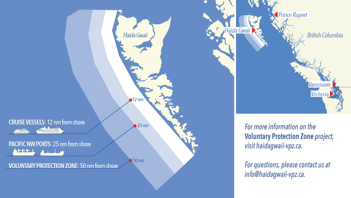
*208/24West Coast Haida Gwaii – Voluntary Protection Zone for Shipping
(Recurrent publication of notice *208/24, originally published in the Notices to Mariners – Monthly Western Edition 02/2024 publication.)
Reference: Notice *1105/21 is cancelled.
Voluntary Protection Zone for Shipping, western shore
of Haida Gwaii
(formerly Queen Charlotte Islands)
Haida Gwaii’s remote location, rugged coastline, variable sea and weather conditions, and rich ecological and cultural heritage make it vulnerable to the potential for pollution from shipping breakdowns and accidents. Increasing the distance vessels travel offshore can increase the amount of time available to address propulsion, steering or other issues, and the likelihood of a towing vessel being able to respond to a vessel in distress or drifting. This in turn reduces the risk of grounding and oil spills.
A Voluntary Protection Zone for Shipping on the western shore of Haida Gwaii is currently in effect. In the Voluntary Protection Zone, commercial vessels of 500 gross tonnage or greater are requested to observe a minimum distance of 50 nautical miles from the western shore of Haida Gwaii with the following exemptions:
Exemptions from requested 50 nm distance:
•Cruise vessels, which are asked to observe a minimum
12 nm distance from shore;
•Vessels transiting from Alaska to British Columbia or
Washington State, or vice versa, through the Voluntary
Protection Zone are asked to observe a distance of at least
25 nm from shore
•No minimum distance is requested for tugs and barges
(including pushing and towing alongside) or vessels engaged
in commercial fishing.
•Vessels to which this bulletin applies are not required to observe requested minimum distances if doing so may compromise navigational, vessel, passenger or cargo safety.
The Voluntary Protection Zone for Shipping coordinates are:
|
54⁰ 15.436' N |
133⁰ 04.788' W |
|
54⁰ 17.572' N |
134⁰ 02.484' W |
|
54⁰ 13.614' N |
134⁰ 19.427' W |
|
54⁰ 11.786' N |
134⁰ 30.841' W |
|
53⁰ 44.036' N |
134⁰ 32.677' W |
|
53⁰ 11.118' N |
134⁰ 16.412' W |
|
52⁰ 18.483' N |
133⁰ 20.917' W |
|
51⁰ 24.590' N |
132⁰ 04.081' W |
|
51⁰ 56.158' N |
131⁰ 01.830' W |
Vessels are requested to adhere to these distances on a voluntary basis and only when it does not jeopardize the safety of navigation, the vessel, the persons onboard, and the cargo.
*301/24Canadian Hydrographic Service – Nautical Charts
|
Charts |
Main Title |
Scale |
Edition Date |
Published |
Cat# |
Price |
|
New Charts |
||||||
|
3656 |
Useless Inlet and Fatty Basin |
1:12 000 |
2024-02-09 |
2024-03-22 |
2 |
$20.00 |
*302/24Canadian Hydrographic Service – Electronic Navigational Charts
|
S-57 ENC Number |
Chart Title |
ENC Compilation Scale |
Published |
|
New Charts |
|||
|
CA29PJ6A (Edn 1.000) |
Western Foxe Basin |
1:175 000 |
2024-03-29 |
|
CA29PKDA (Edn 1.000) |
Eastern Foxe Basin |
1:175 000 |
2024-03-22 |
|
CA45RS2B (Edn 1.000) |
CA45RS2B |
1:90 000 |
2024-03-22 |
|
CA45RSCA (Edn 1.000) |
CA45RSCA |
1:90 000 |
2024-03-22 |
|
CA45RSNA (Edn 1.000) |
CA45RSNA |
1:90 000 |
2024-03-22 |
|
CA45RSYA (Edn 1.000) |
CA45RSYA |
1:90 000 |
2024-03-22 |
|
CA462SCA (Edn 1.000) |
CA462SCA |
1:22 500 |
2024-03-22 |
|
CA462SNA (Edn 1.000) |
CA462SNA |
1:22 500 |
2024-03-22 |
|
CA462SNB (Edn 1.000) |
CA462SNB |
1:22 500 |
2024-03-22 |
|
CA46CR5A (Edn 1.000) |
CA46CR5A |
1:45 000 |
2024-03-22 |
|
CA46CRFA (Edn 1.000) |
CA46CRFA |
1:45 000 |
2024-03-22 |
|
CA46CRRA (Edn 1.000) |
CA46CRRA |
1:45 000 |
2024-03-22 |
|
CA46CS2A (Edn 1.000) |
CA46CS2A |
1:45 000 |
2024-03-22 |
|
CA46CSCA (Edn 1.000) |
CA46CSCA |
1:45 000 |
2024-03-22 |
|
CA46CSNA (Edn 1.000) |
CA46CSNA |
1:45 000 |
2024-03-22 |
|
CA46NRFA (Edn 1.000) |
CA46NRFA |
1:45 000 |
2024-03-22 |
|
CA46NRRA (Edn 1.000) |
CA46NRRA |
1:45 000 |
2024-03-22 |
|
CA46NS2A (Edn 1.000) |
CA46NS2A |
1:45 000 |
2024-03-22 |
|
CA46NS2B (Edn 1.000) |
CA46NS2B |
1:45 000 |
2024-03-22 |
|
CA46NSCA (Edn 1.000) |
CA46NSCA |
1:45 000 |
2024-03-22 |
|
CA46YQUA (Edn 1.000) |
CA46YQUA |
1:45 000 |
2024-03-22 |
|
CA46YR5A (Edn 1.000) |
CA46YR5A |
1:45 000 |
2024-03-22 |
|
CA46YR5B (Edn 1.000) |
CA46YR5B |
1:45 000 |
2024-03-22 |
|
CA46YRFA (Edn 1.000) |
CA46YRFA |
1:45 000 |
2024-03-22 |
|
CA46YRFB (Edn 1.000) |
CA46YRFB |
1:45 000 |
2024-03-22 |
|
CA46YRRA (Edn 1.000) |
CA46YRRA |
1:45 000 |
2024-03-22 |
|
CA46YS2A (Edn 1.000) |
CA46YS2A |
1:45 000 |
2024-03-22 |
|
CA471211 (Edn 1.000) |
CA471211 |
1:45 000 |
2024-03-22 |
|
CA471212 (Edn 1.000) |
CA471212 |
1:22 500 |
2024-03-22 |
|
CA471213 (Edn 1.000) |
CA471213 |
1:45 000 |
2024-03-22 |
|
CA471215 (Edn 1.000) |
CA471215 |
1:22 500 |
2024-03-22 |
|
CA471216 (Edn 1.000) |
CA471216 |
1:45 000 |
2024-03-22 |
|
CA471221 (Edn 1.000) |
CA471221 |
1:22 500 |
2024-03-22 |
|
CA471223 (Edn 1.000) |
CA471223 |
1:22 500 |
2024-03-22 |
|
CA479QJA (Edn 1.000) |
CA479QJA |
1:22 500 |
2024-03-22 |
|
CA479QUA (Edn 1.000) |
CA479QUA |
1:45 000 |
2024-03-22 |
|
CA479QUB (Edn 1.000) |
CA479QUB |
1:45 000 |
2024-03-22 |
|
CA479R5A (Edn 1.000) |
CA479R5A |
1:45 000 |
2024-03-22 |
|
CA479RFA (Edn 1.000) |
CA479RFA |
1:45 000 |
2024-03-22 |
|
CA47KQJA (Edn 1.000) |
CA47KQJA |
1:90 000 |
2024-03-22 |
|
CA47KQJB (Edn 1.000) |
CA47KQJB |
1:90 000 |
2024-03-22 |
|
CA47KQUA (Edn 1.000) |
CA47KQUA |
1:90 000 |
2024-03-22 |
|
CA47KR5A (Edn 1.000) |
CA47KR5A |
1:90 000 |
2024-03-22 |
|
CA47VQ8A (Edn 1.000) |
CA47VQ8A |
1:90 000 |
2024-03-22 |
|
CA47VQJA (Edn 1.000) |
CA47VQJA |
1:90 000 |
2024-03-22 |
|
CA47VQUA (Edn 1.000) |
CA47VQUA |
1:90 000 |
2024-03-22 |
|
CA486Q8A (Edn 1.000) |
CA486Q8A |
1:22 500 |
2024-03-22 |
|
CA486Q8B (Edn 1.000) |
CA486Q8B |
1:22 500 |
2024-03-22 |
|
CA486QJA (Edn 1.000) |
CA486QJA |
1:90 000 |
2024-03-22 |
|
CA4B755A (Edn 1.000) |
CA4B755A |
1:90 000 |
2024-03-29 |
|
CA4B75FA (Edn 1.000) |
CA4B75FA |
1:90 000 |
2024-03-29 |
|
CA4B75RA (Edn 1.000) |
CA4B75RA_6900N12500W |
1:90 000 |
2024-03-29 |
|
CA4B762A (Edn 1.000) |
CA4B762A |
1:90 000 |
2024-03-29 |
|
CA55USRA (Edn 1.000) |
CA55USRA |
1:6 000 |
2024-03-29 |
|
CA566SQA (Edn 1.000) |
CA566SQA |
1:11 000 |
2024-03-15 |
|
CA566SRA (Edn 1.000) |
CA566SRA |
1:11 000 |
2024-03-15 |
|
CA567SJA (Edn 1.000) |
CA567SJA |
1:11 000 |
2024-03-15 |
|
CA567SKA (Edn 1.000) |
CA567SKA |
1:11 000 |
2024-03-15 |
|
CA567SLA (Edn 1.000) |
CA567SLA |
1:11 000 |
2024-03-15 |
|
CA571057 (Edn 1.000) |
CA571057 |
1:6 000 |
2024-03-01 |
|
CA571251 (Edn 1.000) |
CA571251 |
1:11 000 |
2024-03-22 |
|
CA571252 (Edn 1.000) |
CA571252 |
1:11 000 |
2024-03-22 |
|
CA571253 (Edn 1.000) |
CA571253 |
1:11 000 |
2024-03-22 |
|
CA597L1A (Edn 1.000) |
CA597L1A |
1:11 000 |
2024-03-29 |
|
New Editions |
|||
|
CA262Q8A (Edn 2.000) |
CA262Q8A |
1:1 750 000 |
2024-03-01 |
|
CA279Q8A (Edn 2.000) |
CA279Q8A |
1:1 750 000 |
2024-03-29 |
|
CA279Q8B (Edn 2.000) |
CA279Q8B |
1:175 000 |
2024-03-01 |
|
CA279Q8B (Edn 3.000) |
CA279Q8B |
1:175 000 |
2024-03-29 |
|
CA370381 (Edn 8.000) |
Strait of Georgia, Central Portion/Partie Centrale (Part 1 of 2) |
1:40 000 |
2024-03-22 |
|
CA376062 (Edn 13.000) |
West Point à/to Baie de Tracadie |
1:50 000 |
2024-03-15 |
|
CA376109 (Edn 9.000) |
Country Island to/à Barren Island |
1:30 000 |
2024-03-01 |
|
CA376660 (Edn 3.000) |
Cape St. John to/à St. Anthony |
1:75 000 |
2024-03-22 |
|
CA376689 (Edn 3.000) |
North Head to/à Murphy Head |
1:50 000 |
2024-03-22 |
|
CA45FRFA (Edn 2.000) |
Transit5000N06000W |
1:22 500 |
2024-03-01 |
|
CA470095 (Edn 8.000) |
Jervis Inlet |
1:25 000 |
2024-03-22 |
|
CA470756 (Edn 4.000) |
Halibut Bank to/à Ballenas Channel |
1:15 000 |
2024-03-22 |
|
CA471014 (Edn 3.000) |
Hippa Island, Seal Inlet, Tartu Inlet, Masset Inlet |
1:180 000 |
2024-03-01 |
|
CA471020 (Edn 4.000) |
Selwyn Inlet |
1:45 000 |
2024-03-29 |
|
CA471021 (Edn 5.000) |
Atli Inlet |
1:180 000 |
2024-03-29 |
|
CA476547 (Edn 5.000) |
Grand Harbour |
1:12 500 |
2024-03-15 |
|
CA476673 (Edn 5.000) |
Cape Daly to/à Amiktok Island |
1:20 000 |
2024-03-22 |
|
CA476674 (Edn 4.000) |
Amiktok Island to Osborne Point |
1:20 000 |
2024-03-22 |
|
CA476681 (Edn 3.000) |
Osborne Point to Cape Kakkiviak |
1:20 000 |
2024-03-22 |
|
CA543M8A (Edn 2.000) |
Port4550N07390W |
1:6 000 |
2024-03-01 |
|
CA54AQGA (Edn 2.000) |
Charlottetown Harbour North |
1:0 |
2024-03-29 |
|
CA55VSAA (Edn 2.000) |
Port5140N05720W |
1:6 000 |
2024-03-22 |
|
CA570123 (Edn 10.000) |
Vancouver Harbour Central Portion/Partie Centrale |
1:6 000 |
2024-03-08 |
|
CA570626 (Edn 4.000) |
Kitimat Harbour |
1:7 500 |
2024-03-29 |
|
Charts Permanently Withdrawn |
|||
|
CA370145 |
Strait of Georgia, Southern Portion/Partie Sud |
Cancelled by CA471221,CA471216,CA471213,CA471212 |
|
|
CA370367 |
Juan de Fuca Strait to/à Strait of Georgia (Western Portion, Part 1 of 2) |
Cancelled by CA471223,CA471221 |
|
|
CA370368 |
Juan de Fuca Strait to/à Strait of Georgia (Eastern Portion, Part 2 of 2) |
|
|
|
CA370382 |
Strait of Georgia, Central Portion/Partie Centrale (Part 2 of 2) |
Cancelled by CA471215,CA471213,CA471212,CA471211 |
|
|
CA376049 |
Nunasuk Island to Calf Cow and Bull Islands |
|
|
|
CA376050 |
Seniartlit Islands to Nain |
|
|
|
CA376094 |
Strait of Belle Isle |
Cancelled by CA45RSNA |
|
|
CA376351 |
Dog Islands to/à Cape Makkovik |
|
|
|
CA376352 |
Makkovik Bay (Continuation A) |
|
|
|
CA376355 |
Approaches to Cartwright, Black Island to Tumbledown Dick Island |
|
|
|
CA376356 |
Quaker Hat to/à Cape Harrison |
|
|
|
CA376358 |
Green Bay to/à Double Island |
|
|
|
CA376361 |
Cape Makkovik to/à Winsor Harbour Island |
|
|
|
CA376362 |
Kaipokok Bay |
|
|
|
CA376363 |
Cut Throat Island to/à Quaker Hat |
|
|
|
CA376368 |
Cape Harrigan to/aux Kitlit Islands |
|
|
|
CA376370 |
Cape Harrison to Dog Islands |
|
|
|
CA376429 |
Corbett Island to Ship Harbour Head |
|
|
|
CA376483 |
Davis Inlet to/aux Seniarlit Islands |
|
|
|
CA376596 |
Domino Point to Cape North |
|
|
|
CA376597 |
Table Harbour, Continuation at same scale |
Cancelled by CA46CSCA |
|
|
CA376650 |
Cape Kiglapait to Khikkertarsoak North Island |
|
|
|
CA376665 |
Hare Islands to/à North Head |
|
|
|
CA376668 |
Khikkertarsoak North Island to/à Morhardt Point |
|
|
|
CA376669 |
Khikkertarsoak North Island To Morhardt Point , Continuation A |
|
|
|
CA376738 |
Lake Melville |
|
|
|
CA376739 |
Epinette Point to/à Terrington Basin |
|
|
|
CA376811 |
South Auliatsivik Island to/à Fenstone Tickle Island |
|
|
|
CA376820 |
Approaches to Hamilton Inlet |
|
|
|
CA376822 |
Winsor Harbour Island to/aux Kikkertaksoak Islands |
|
|
|
CA376823 |
Winsor Harbour Island to/aux Kikkertaksoak Islands |
|
|
|
CA470003 |
Haro Strait, Boundary Pass and/et Satellite Channel |
Cancelled by CA471223,CA471221 |
|
|
CA470004 |
Howe Sound |
Cancelled by CA471215,CA471213,CA471212,CA471211 |
|
|
CA470005 |
North Pender Island to/à Thetis Island |
Cancelled by CA471221,CA471213 |
|
|
CA470070 |
Thetis Island to/à Nanaimo |
Cancelled by CA471221,CA471213,CA471212 |
|
|
CA470075 |
Race Rocks to/à D'Arcy Island |
Cancelled by CA471223 |
|
|
CA470194 |
Indian Arm - Continuation A |
Cancelled by CA471216 |
|
|
CA470411 |
Welcome Passage |
Cancelled by CA571253,CA571252,CA571251 |
|
|
CA476360 |
Niger Sound |
Cancelled by CA462SNB |
|
|
CA476366 |
Ice Tickle and/et Indian Harbour |
Cancelled by CA46NS2B |
|
|
CA476369 |
Windy Tickle |
|
|
|
CA476380 |
St. Lewis Sound and/et Inlet |
|
|
|
CA476485 |
South of / Sud de Drawbucket Tickle |
Cancelled by CA479R5A |
|
|
CA476494 |
Sandwich Bay |
|
|
|
CA476495 |
Continuation A - Sandwich Bay |
Cancelled by CA46CS2A |
|
|
CA476568 |
Savage Cove to/à St. Barbe Bay |
|
|
|
CA476600 |
Akuliakatak Peninsula to Satosoak Island |
|
|
|
CA476630 |
Hawke Bay and / et Deer Pass (Squasho Run) |
|
|
|
CA476631 |
Head of Hawke Bay |
|
|
|
CA476634 |
Approaches to/à White Bear Arm |
|
|
|
CA476635 |
Occasional Harbour |
Cancelled by CA462SNA |
|
|
CA476734 |
Groswater Bay |
|
|
|
CA476735 |
Ticoralak Island to/à Green Island |
|
|
*303/24Transport Canada - Ship Safety Bulletins #06, #07 and #08/2024
New Ship Safety Bulletins have recently been
posted on the
Transport Canada website.
To view or download these bulletins, please click on the
links below:
SSB#06/2024 – Maintaining fire
safety systems and
equipment
RDIMS#
19958872
SSB#07/2024 – Irish seafarers
can now seek Canadian recognition of their STCW
certificates
RDIMS#
20127556
SSB#08/2024 – Requirements for
the use of an Electronic Record Books
System
RDIMS#
20045967
Sign up for e-Bulletin to receive an e-mail notice each time a new Ship Safety Bulletin is published on our website.
Contact us at marinesafety-securitemaritime@tc.gc.ca or 1-855-859-3123 (Toll Free).
*304/24Canadian Hydrographic Service – Chart 3895 Partially Replaced by New Chart 3816
Chart 3895, Plans – Dixon Entrance, has been partially replaced by new chart 3816, Parry Passage. The plan titled Parry Passage is now cancelled. The remaining plans will be cancelled at a later date.
Section 1A: Temporary and Preliminary Notices
Reminder – Comment Period for Active Preliminary Notices
No notices applicable for this edition.
Inland Waters
Temporary Notices
No notices applicable for this edition.
Preliminary Notices
Arctic Region
|
Comment
Submission |
Comments should be directed to the following: |
*316(P)/24Demarcation Bay to/à Philips Bay – Aid to Navigation to be Discontinued
Reference chart: 7661
The Canadian Coast Guard proposes to permanently discontinue the following aid to navigation:
|
Aid Name |
LL # |
Position |
|
Shingle Point |
4618 |
69° 00’ 29.4”N 137° 34’ 21.7”W |
Initial publication date: Friday, March 29, 2024
Comment submission
deadline: Thursday, June 27, 2024
(A2024-004)
Pacific Coast
Temporary Notices
No notices applicable for this edition.
Preliminary Notices
No notices applicable for this edition.
SECTION 2 - CHART CORRECTIONS
3050 - West Arm Kootenay Lake, Procter Light to Harrop Narrows - Sheet/Feuille 9 - New Edition - 03-MAY-1996 - NAD 1927
Download Patch - https://www.notmar.gc.ca/chsftp/patches/3050_6204892_1_202402191017.pdf
3490 - Fraser River/Fleuve Fraser, Sand Heads to/à Douglas Island, Compartment A-B - New Edition - 02-NOV-2012 - World Geodetic System 1984
(See Chart 1, I10)
3526 - Howe Sound - New Edition - 01-JUL-2005 - NAD 1983
3543 - Cordero Channel - New Edition - 27-NOV-1992 - NAD 1983
(See Chart 1, L30.1)
50°22′16.5″N 125°42′42.8″W
50°22′15.0″N 125°42′33.4″W
50°22′14.7″N 125°42′16.2″W
50°22′11.2″N 125°42′06.9″W
50°22′07.0″N 125°41′35.3″W
50°22′07.5″N 125°40′56.4″W
50°22′16.8″N 125°39′53.5″W
50°22′17.8″N 125°38′47.8″W
50°22′36.0″N 125°34′59.0″W
50°22′28.3″N 125°34′19.3″W
and 50°22′09.5″N 125°33′36.4″W
3544 - Johnstone Strait, Race Passage and/et Current Passage - New Edition - 25-SEP-1987 - NAD 1983
(See Chart 1, L30.1)
50°22′07.4″N 125°40′53.7″W
50°22′07.2″N 125°41′40.5″W
50°22′11.6″N 125°42′08.4″W
50°22′14.5″N 125°42′15.0″W
50°22′15.1″N 125°42′35.5″W
50°22′16.5″N 125°42′44.3″W
50°22′16.6″N 125°43′32.8″W
50°22′23.5″N 125°44′32.6″W
50°22′20.5″N 125°45′18.2″W
50°22′31.3″N 125°46′30.8″W
50°22′54.3″N 125°48′06.6″W
50°22′56.2″N 125°48′16.3″W
50°22′56.2″N 125°48′32.5″W
50°23′05.1″N 125°48′52.9″W
50°23′09.2″N 125°49′09.5″W
50°23′11.6″N 125°49′44.3″W
50°23′07.6″N 125°50′22.5″W
50°23′07.3″N 125°50′42.3″W
50°23′02.2″N 125°51′15.7″W
50°23′17.8″N 125°53′28.2″W
50°23′44.8″N 125°54′47.8″W
50°23′52.0″N 125°55′33.4″W
50°23′53.7″N 125°56′25.0″W
50°23′52.6″N 125°56′28.6″W
50°23′57.2″N 125°57′18.9″W
50°23′56.8″N 125°57′23.4″W
50°23′57.6″N 125°57′30.6″W
and 50°23′57.0″N 125°57′35.8″W
3670 - Broken Group - New Edition - 21-OCT-1994 - NAD 1983
Download Patch - https://www.notmar.gc.ca/chsftp/patches/3670_6204850_1_202403011036.pdf
(See Chart 1, I10)
(See Chart 1, I10)
(See Chart 1, I10)
(See Chart 1, I10)
(See Chart 1, I10)
(See Chart 1, K11)
(See Chart 1, I10)
(See Chart 1, K11)
(See Chart 1, I10)
(See Chart 1, I10)
3671 - Barkley Sound - New Edition - 04-NOV-2005 - NAD 1983
(See Chart 1, I10)
(See Chart 1, K11)
(See Chart 1, I10)
(See Chart 1, I10)
(See Chart 1, I10)
(See Chart 1, K12)
(See Chart 1, K12)
(See Chart 1, K11)
(See Chart 1, K11)
3673 - Clayoquot Sound, Tofino Inlet to/à Millar Channel - New Chart - 01-DEC-1995 - NAD 1983
(See Chart 1, L41.1)
49°09′05.0″N 125°54′55.6″W
49°09′02.4″N 125°54′49.9″W
49°08′59.8″N 125°54′43.4″W
and 49°08′59.3″N 125°54′38.6″W
(See Chart 1, L41.1)
and 49°08′59.6″N 125°54′38.6″W
3685 - TOFINO - NEW EDITION - 25-AUG-1995 - NAD 1983
(See Chart 1, L41.1)
49°09′05.0″N 125°54′55.6″W
49°09′02.4″N 125°54′49.9″W
49°08′59.8″N 125°54′43.4″W
and 49°08′59.2″N 125°54′38.9″W
(See Chart 1, L41.1)
and 49°08′59.6″N 125°54′38.6″W
3800 - Dixon Entrance - New Chart - 06-MAY-2011 - NAD 1983
(See Chart 1, L25)
(See Chart 1, L25)
(See Chart 1, L25)
3808 - Juan Perez Sound - New Edition - 30-DEC-2005 - NAD 1983
(See Chart 1, L25)
(See Chart 1, L25)
(See Chart 1, L25)
3853 - Cape St. James to/à Cumshewa Inlet and/et Tasu Sound - New Edition - 02-MAR-1990 - NAD 1927
(See Chart 1, L25)
3869 - Skidegate Channel to/à Tian Rock - New Edition - 28-NOV-1986 - Unknown
(See Chart 1, I10)
(See Chart 1, I10)
(See Chart 1, I10)
(See Chart 1, I10)
(See Chart 1, I10)
3890 - Approaches to/Approches à Skidegate Inlet - New Chart - 14-MAR-1986 - NAD 1927
(See Chart 1, I10)
3908 - KITIMAT - NEW CHART - 15-MAR-2013 - NAD 1983
(See Chart 1, L30.1)
53°59′28.2″N 128°40′32.6″W
53°59′30.5″N 128°40′34.6″W
53°59′48.1″N 128°40′38.8″W
and 53°59′48.5″N 128°40′41.2″W
Download Patch - https://www.notmar.gc.ca/chsftp/patches/3908_6204897_1_202402271423.pdf
3908 - Kitimat Harbour - New Chart - 15-MAR-2013 - NAD 1983
(See Chart 1, L30.1)
53°58′14.4″N 128°39′03.1″W
53°58′14.5″N 128°39′11.8″W
53°58′17.3″N 128°39′20.2″W
53°58′21.5″N 128°39′29.2″W
53°58′27.2″N 128°39′34.0″W
53°58′38.7″N 128°39′35.4″W
53°59′00.5″N 128°39′23.1″W
53°59′12.8″N 128°39′26.5″W
53°59′17.6″N 128°39′31.9″W
53°59′21.2″N 128°39′42.9″W
53°59′28.2″N 128°40′32.6″W
53°59′32.0″N 128°40′35.3″W
53°59′48.1″N 128°40′38.8″W
and 53°59′48.5″N 128°40′41.2″W
(See Chart 1, Q58)
(See Chart 1, Q40)
(See Chart 1, E23)
and 53°59′45.8″N 128°41′11.7″W
(See Chart 1, Qc)
(See Chart 1, Qb)
(See Chart 1, F16)
53°59′14.9″N 128°41′42.6″W
53°59′14.9″N 128°41′36.9″W
53°59′15.1″N 128°41′36.1″W
53°59′15.4″N 128°41′35.6″W
53°59′15.6″N 128°41′35.6″W
53°59′16.0″N 128°41′36.4″W
and 53°59′15.9″N 128°41′42.7″W
(See Chart 1, L25)
(See Chart 1, L25)
(See Chart 1, L30.1)
and 53°58′27.0″N 128°39′24.3″W
(See Chart 1, L30.1)
and 53°58′24.0″N 128°39′25.9″W
3912 - Port Canaveral - New Edition - 14-AUG-2015 - World Geodetic System 1984
(See Chart 1, Q58)
3945 - Approaches to/Approches à Douglas Channel - New Chart - 25-DEC-2009 - NAD 1983
(See Chart 1, Q58)
(See Chart 1, Q58)
(See Chart 1, Q58)
3945 - Coghlan Anchorage - New Chart - 25-DEC-2009 - NAD 1983
(See Chart 1, Q58)
3947 - Grenville Channel to/à Chatham Sound - New Chart - 25-DEC-2009 - NAD 1983
(See Chart 1, Qe)
3958 - Prince Rupert Harbour - New Edition - 13-DEC-2013 - World Geodetic System 1984
(See Chart 1, Qe)
3959 - Hudson Bay Passage - New Chart - 11-DEC-1987 - NAD 1983
(See Chart 1, L25)
3963 - Work Channel A-B - New Chart - 26-OCT-1990 - NAD 1983
(See Chart 1, L25)
3977 - Douglas Channel - New Chart - 27-DEC-2013 - World Geodetic System 1984
(See Chart 1, L25)
(See Chart 1, L25)
(See Chart 1, L30.1)
53°58′14.4″N 128°39′03.1″W
53°58′14.5″N 128°39′11.8″W
53°58′17.3″N 128°39′20.2″W
53°58′21.5″N 128°39′29.2″W
53°58′27.2″N 128°39′34.0″W
53°58′38.7″N 128°39′35.4″W
53°59′00.5″N 128°39′23.1″W
53°59′12.8″N 128°39′26.5″W
53°59′17.6″N 128°39′31.9″W
53°59′21.2″N 128°39′42.9″W
53°59′28.2″N 128°40′32.6″W
53°59′32.0″N 128°40′35.3″W
53°59′48.1″N 128°40′38.8″W
and 53°59′48.5″N 128°40′41.2″W
(See Chart 1, Q58)
(See Chart 1, Q58)
3984 - Principe Channel Southern Portion/Partie Sud - New Chart - 25-DEC-2009 - NAD 1983
(See Chart 1, Q58)
3985 - Principe Channel Central Portion/Partie Centrale and/et Petrel Channel - New Chart - 25-DEC-2009 - NAD 1983
(See Chart 1, Q58)
3986 - Browning Entrance - New Chart - 25-DEC-2009 - NAD 1983
(See Chart 1, Q58)
(See Chart 1, Q58)
6408 - Cache Island to/à Rabbitskin River Kilometre 233 / Kilomètre 301 - New Edition - 31-DEC-2010 - NAD 1983
(See Chart 1, I10)
6423 - Askew Islands to/à Bryan Island Kilometre 1180 / Kilometre 1240 - New Edition - 11-MAR-2022 - World Geodetic System 1984
(See Chart 1, I10)
(See Chart 1, I10)
(See Chart 1, Qb)
to 66°51′49.9″N 130°07′58.3″W
(See Chart 1, Qb)
to 66°52′15.9″N 130°07′27.6″W
(See Chart 1, Qp)
to 66°52′47.0″N 130°07′05.7″W
(See Chart 1, Qc)
to 66°59′03.9″N 130°14′43.2″W
(See Chart 1, Qc)
(See Chart 1, Qc)
(See Chart 1, Qb)
(See Chart 1, Qc)
(See Chart 1, Qb)
(See Chart 1, Qb)
to 67°00′08.1″N 130°12′36.3″W
7621 - Amundsen Gulf - New Edition - 25-FEB-2022 - NAD 1983
(See Chart 1, K12)
(See Chart 1, I10)
(See Chart 1, I10)
7665 - Franklin Bay and/et Darnley Bay - New Chart - 13-JUN-1986 - NAD 1927
(See Chart 1, K12)
(See Chart 1, I10)
(See Chart 1, I10)
SECTION 3 - RADIO AIDS TO MARINE NAVIGATION CORRECTIONS
*317/24Radio Aids to Marine Navigation 2024 (Atlantic, St. Lawrence, Great Lakes, Lake Winnipeg, Arctic and Pacific)
Page 2-33
DELETE AS FOLLOWS:
Table 2-17 - Prince Rupert MCTS/VAJ - Ship/Shore Communications
|
Sites located at |
Channels |
Frequencies |
Remarks |
|
|
Transmit |
Receive |
|||
|
Dundas Island
54°31'16"N |
Ch16 |
- |
- |
|
|
Kitimat
54°03'20"N |
Ch11 |
- |
- |
|
|
Maitland Island
53°44’05”N |
Ch11 |
- |
- |
|
|
Porcher Island
53°55’04”N |
Ch11 |
- |
- |
|
|
… |
… |
… |
… |
… |
Page 2-38
DELETE AS FOLLOWS:
Table 2-18 - Prince Rupert MCTS/VAJ - Broadcasts
|
Time PST |
Site |
Frequency or Channel |
Contents |
|---|---|---|---|
|
… |
… |
… |
… |
|
Continuous |
Mount Hays
Mount Dent |
Ch21B (2021) |
Radiotelephony
•Technical
marine synopsis, marine forecast and marine extended
forecast for marine forecast areas 2, 3, 4, 5, 13, 14,
15, 16, 17. •All navigational warnings. |
|
Klemtu |
WX1 |
||
|
Barry Inlet |
WX2 |
||
|
Cumshewa |
WX3 |
||
|
Continuous |
Mount Ozzard
Esperanza |
C21B (2021) |
Radiotelephony
•Technical
marine synopsis, marine forecast and marine extended
forecast for marine forecast areas 1, 5, 6, 7, 8, 13,
14. •All navigational warnings. |
|
Eliza Dome |
WX1 |
||
|
Port Alberni |
WX2 |
||
|
Estevan Point |
WX3 |
* Kitimat site to be permanently
relocated to Maitland Island in 2021. Kitimat CMB on standby and
not transmitting while Maitland Island undergoes operational
testing.
** Maitland Island site in operational
test mode.
Page 2-51
DELETE AS FOLLOWS:
Table 2-25 - Victoria MCTS/VAK - Ship/Shore Communications
|
Sites located at |
Channels |
Frequencies |
Remarks |
|
|
Transmit |
Receive |
|||
|
… |
… |
… |
… |
… |
|
Discovery Mountain |
Ch16 |
- |
- |
- |
|
|
|
|
- |
- |
|
Port Hardy |
Ch16 |
- |
- |
- |
|
… |
… |
… |
… |
… |
Pages 2-51 to 2-53
DELETE AS FOLLOWS:
Table 2-26 - Victoria MCTS/VAK - Broadcasts
|
Time PST |
Site |
Frequency or Channel |
Contents |
|
07:10 |
Mount Parke |
Ch21B (2021) |
Radiotelephony •All navigational warnings. •Notices to Fish Harvesters. |
|
Watts Point |
WX1 |
||
|
Bowen Island |
WX3 |
||
|
07:20 |
Texada Island |
WX1 |
Radiotelephony •All navigational warnings. •Notices to Fish Harvesters. |
|
Port Hardy |
WX3 |
||
|
Discovery Mountain |
Ch21B (2021) |
||
|
13:10 |
Mount Parke |
Ch21B (2021) |
Radiotelephony •All navigational warnings. •Notices to Fish Harvesters. |
|
Watts Point |
WX1 |
||
|
Bowen Island |
WX3 |
||
|
13:20 |
Texada Island |
WX1 |
Radiotelephony •All navigational warnings. •Notices to Fish Harvesters. |
|
Port Hardy |
WX3 |
||
|
Discovery Mountain |
Ch21B (2021) |
||
|
20:20 |
Texada Island |
WX1 |
Radiotelephony •All navigational warnings. •Notices to Fish Harvesters. |
|
Port Hardy |
WX3 |
||
|
Discovery Mountain |
Ch21B (2021) |
||
|
21:10 |
Mount Parke |
Ch21B (2021) |
Radiotelephony •All navigational warnings. •Notices to Fish Harvesters. |
|
Watts Point |
WX1 |
||
|
Bowen Island |
WX3 |
||
|
Continuous |
Mount Parke |
Ch21B (2021) |
Radiotelephony •Technical marine synopsis and marine forecast for marine forecast areas 8, 9, 10, 11.
•Extended
forecast for marine forecast areas 7, 8, 9, 10,
11. •Fraser River Salmon Fishery Information. |
|
Watts Point |
WX1 |
||
|
Bowen Island |
WX3 |
||
|
Continuous |
Mount Helmcken |
WX3 |
Radiotelephony •Navigational warnings.
•Technical
marine synopsis, marine forecast and extended marine
forecast for marine forecast areas 7, 8, 9, 10,
11. •Automated Weather Reports for Juan de Fuca Strait: Cape Flattery, “JA” Buoy, Hein Bank, Smith Island, Ogden Point. |
|
Continuous |
|
|
Radiotelephony •Navigational warnings
•Technical
marine synopsis marine forecast and extended marine
forecast for marine forecast areas 5, 6, 11, 12, 13,
14. •Lighthouse Weather Reports: McInnes Island, Addenbroke Island, Egg Island, Pine Island, Scarlett Point, Pulteney Point, Chatham Point, Cape Scott, Quatsino. |
|
Port Hardy |
WX3 |
||
|
Continuous |
Texada Island |
WX1 |
Radiotelephony
•Navigational
warnings •Local and Lighthouse Weather Reports: Chatham Point, Cape Mudge, Cape Lazo, Chrome Island, Merry Island, Entrance Island. |
Page 2-73
AMEND AS FOLLOWS:
Table 2-41 - Radar Beacons Located in Northwest Territories
|
Name and Location |
Identifier |
Remarks |
|
… |
… |
… |
|
Pitt Island
69°09'15"N |
─ • ─ |
Navigation season only. |
|
Pullen Island
69°46' |
─ ─ • |
Navigation season only. |
|
Baillie Islands
70°37'38.7"N |
─ • ─ |
Navigation season only. |
|
… |
… |
… |
SECTION 4 - CANADIAN SAILING DIRECTIONS CORRECTIONS
The following Canadian Sailing Directions volumes have recently been updated on the Canadian Hydrographic Service website.
|
No. |
Title |
|
Atlantic Coast |
|
|
ATL104 |
Cape North to Cape Canso (including Bras d’Or Lake) |
|
ATL108 |
Gulf of St. Lawrence (Southwest Portion) |
|
ATL110 |
St. Lawrence River, Cap Whittle / Cap Gaspé to Les Escoumins and Anticosti Island |
|
ATL111 |
St. Lawrence River, Île Verte to Québec and Fjord du Saguenay |
|
ATL112 |
St. Lawrence River, Cap-Rouge to Montréal and Rivière Richelieu |
|
Central Canada |
|
|
CEN303 |
Welland Canal and Lake Erie |
|
Northern Canada |
|
|
ARC403 |
Western Arctic |
Each volume includes a section entitled “Record of Changes” which lists all updates that are incorporated during the current calendar year.
SECTION 5 - LIST OF LIGHTS, BUOYS AND FOG SIGNALS CORRECTIONS
The amendments are highlighted and deletions are crossed out. For general and region-specific
information on the List of Lights, click on the following links:
Newfoundland and Labrador Coast,
Atlantic Coast,
Inland Waters and
Pacific Coast.
PACIFIC COAST
| No. | Name |
Position ----- Latitude N. Longitude W. |
Light Characteristics |
Focal Height in m. above water |
Nominal Range |
Description ----- Height in meters above ground |
Remarks ----- Fog Signals |
|||
|---|---|---|---|---|---|---|---|---|---|---|
WEST COAST, VANCOUVER ISLAND (LL 66 – 179.1) |
||||||||||
| 173 |
Seapool Rocks light and whistle buoy Y49 Racon - . - (K) X & S Bands |
Entrance to Trevor Channel, Barkley Sound. 48 48 53.8 125 12 19.7 |
Fl | G | 4s | ..... | ….. | Green, marked “Y49”. |
Year round. Chart:3671 Edn 03/24 |
|
NORTHERN STRAIT OF GEORGIA (LL 447.5 – 510) |
||||||||||
|
484.1 484.2G5574.64 G5574.65 |
Whiterock Passage range 1 |
| | | | | | | | | |
W. side of Read Island. 064°41’
26.8 m50 14 45.7 125 06 13.8 from front. |
F
F
|
Y
Y
|
…..
…..
|
2.8
5.1
|
10
10
|
Mast, white daymark with red vertical
stripe.
Mast, white daymark with red vertical
stripe.
|
Year round.
Year round.Chart:3537 Edn 03/24 (P24-010, 011) |
|
484.3 484.4G5574.7 G5574.71 |
Whiterock Passage range 2 |
| | | | | | | | | |
W. side of Read Island. 211°29’
23.8 m50 14 37.9 125 06 27.5 from front. |
F
F
|
Y
Y
|
…..
…..
|
3.9
6.2
|
10
10
|
Mast, white daymark with red vertical
stripe.
Mast, white daymark with red vertical
stripe.
|
Year round.
Year round.Chart:3537 Edn 03/24 (P24-012, 013) |
Report a problem on this page
- Date modified: