
Archived information
The Standard on Web Usability replaces this content. This content is archived because Common Look and Feel 2.0 Standards have been rescinded.
Archived information is provided for reference, research or recordkeeping purposes. It is not subject to the Government of Canada Web Standards and has not been altered or updated since it was archived.
Notices to Mariners
April 28, 2023

Safety First, Service Always
Monthly Western Edition
CONTENTS
| Section 1 | General and Safety Information |
| Section 1A | Temporary and Preliminary Notices |
| Section 2 | Chart Corrections |
| Section 3 | Radio Aids to Marine Navigation Corrections |
| Section 4 | Canadian Sailing Directions Corrections |
| Section 5 | List of Lights, Buoys and Fog Signals Corrections |
Notices to Mariners – Monthly Western Edition
Edition No. 04/2023
Aussi disponible en français :
Avis aux navigateurs – Édition mensuelle de l’Ouest
Édition n° 04/2023
Published under the Authority of:
Canadian Coast Guard Programs
Aids to Navigation and Waterways
Fisheries and Oceans Canada
Montreal, QC H2Y 2E7
For more information, contact Notmar.XNCR@dfo-mpo.gc.ca.
© His Majesty the King in Right of Canada,
as represented by the Minister of Fisheries, Oceans
and the Canadian Coast Guard, 2023.
Cat. No. Fs152-9E-PDF (Electronic PDF, English)
ISSN 2817-0253
Cat. No. Fs152-9F-PDF (Electronic PDF, French)
ISSN 2817-0261
Explanatory Notes – Notices to Mariners (NOTMAR)
Geographical positions refer directly to the graduations of the largest scale Canadian Hydrographic Service chart (unless otherwise indicated).
Bearings refer to the true compass and are measured clockwise from 000° (North) clockwise to 359°; those relating to lights are from seaward.
Visibility of lights is that in clear weather.
Depths - The units used for soundings (metres, fathoms or feet) are stated in the title of each chart.
Elevations are normally given above Higher High Water, Large Tide (unless otherwise indicated).
Distances may be calculated as follows:
1 nautical mile = 1,852 metres (6,076.1 feet)
1 statute mile = 1,609.3 metres (5,280 feet)
1 metre = 3.28 feet
Temporary and Preliminary Notices to Mariners – Section 1A of Notices to Mariners
These notices are indicated by a (T) or a (P), respectively. Please note that nautical charts are not amended by the Canadian Hydrographic Service for temporary (T) and preliminary (P) notices. It is recommended that mariners chart these corrections in pencil. For the list of charts affected by (T) & (P) notices, please refer to the current Notices to Mariners - Monthly Summary of Temporary and Preliminary Notices publication.
Suggestions and Corrections Form
This form is specifically for suggestions and corrections to Notices to Mariners publications. It is available online and also in fillable PDF format included with the monthly publication ZIP file.
To submit comments and suggestions on possible improvements to the various publications and services: Notmar.XNCR@dfo-mpo.gc.ca.
To report chart discrepancies and/or corrections to the Canadian Sailing Directions booklets: Fill out the Marine Information Reporting Form and/or email chsinfo@dfo-mpo.gc.ca.
To report emergencies or navigational hazards: Contact your nearest MCTS centre
- VHF channel 16 (156.8 MHz)
- MF/HF frequency 2182 kHz/4125 kHz (where available)
- ∗16 on a cellphone (where available)
NOTMAR Website – Monthly Editions, Chart Corrections and Chart Patches
The NOTMAR website allows users to access the monthly publications,
chart corrections, and chart patches.
Users can subscribe for free to the email notification service
to receive notifications when charts of interest are updated, including their patches, as well as when a new Monthly Edition of Notices to Mariners is published.
In addition, the monthly publication and related
files to download, such as chart patches, can be obtained
all together through the download of a single ZIP file.
Explanatory Notes – Canadian Hydrographic Service (CHS)
Chart Corrections – Section 2 of Notices to Mariners
Corrections to nautical charts will be listed in numerical order by chart number. Each chart correction listed applies only to that particular chart. Related charts, if any, will have their own specific correction listed separately.
Users should also refer to CHS Chart 1: Symbols, Abbreviations and Terms for additional information pertaining to the correction of charts.
The illustration below describes the elements that will comprise a typical Section 2 chart correction:

The last correction number is identified with the LNM/D or Last Notice to Mariners Number / Date.
Mariners are advised that only the most critical changes that directly affect safety to navigation are issued in “Section 2 – Chart Corrections.” This limitation is required to ensure that charts remain as clear and easy to read as possible. As a result, mariners may see minor discrepancies of a non-critical nature between information in official publications. For example, a small change in the nominal range or focal height of a light may not result in the production of a chart correction in Notices to Mariners, but may result in a correction in the List of Lights, Buoys and Fog Signals publication.
Note: In the case of a discrepancy between information provided on CHS charts relating to aids to navigation, and the List of Lights, Buoys and Fog Signals publication, the latter shall be deemed as containing the most up-to-date information.
Canadian Nautical Charts & Publications
A source list of Canadian nautical charts and publications is published in Notice No. 14 of the Notices to Mariners Annual Edition 2023. The source supply and the prices effective at the time of printing are listed. For current chart edition dates, please refer to the following website: www.chs-shc.gc.ca/charts-cartes/paper-papier/index-eng.asp
Explanatory Notes – Marine Communications and Traffic Services (MCTS)
Navigational Warnings / Notices to Shipping
The Canadian Coast Guard (CCG) is implementing a number of changes to the aids to navigation system in Canada.
These changes are advertised as Navigational Warnings, formerly called Notices to ShippingFootnote 1, that are broadcast by the CCG, and are then followed up with Notices to Mariners, then charts are updated by hand correction, reprints or new editions.
Mariners are advised that all relevant Navigational Warnings (NAVWARN) should be kept until superseded by Notices to Mariners or through revised charts issued by the Canadian Hydrographic Service (CHS).
NAVWARN are accessible on the applicable regional page on the CCG Navigational Warnings website at http://nis.ccg-gcc.gc.ca.
CHS is reviewing the impact of these changes with CCG and together are preparing an action plan on the issuing of chart revisions.
For further information, contact your regional NAVWARN Issuing Desk.
Western Region
Prince Rupert MCTS Centre
Canadian Coast Guard
Bag 4444
Prince Rupert, BC V8J 4K2
Telephone: 250-627-3070
Email: NAVWARN.MCTSPrinceRupert@innav.gc.ca
Website: http://www.marinfo.gc.ca/e-nav
Arctic Region
* Iqaluit MCTS Centre
Operational from approximately mid-May until late December.
Canadian Coast Guard
P.O. Box 189
Iqaluit, NU X0A 0H0
“A” Series
Telephone: 867-979-5269
“H” Series
Telephone: 867-979-0310
Facsimile: 867-979-4264
Email: NAVWARN.MCTSIqaluit@innav.gc.ca
Website: http://www.marinfo.gc.ca/e-nav
* Service available in English and French.
Index
Numerical Index of Canadian Charts Affected
This numerical index lists all nautical charts mentioned in this monthly edition of Notices to Mariners. Only charts appearing in Section 2 of this publication require a chart correction. The appearance of charts in all other sections, particularly those related to the correction of other nautical publications, is included here for reference.
| 3053 | 3545 | 3598 | 3958 |
| 3419 | 3546 | 3605 | 3964 |
| 3424 | 3547 | 3668 | 6258 |
| 3440 | 3549 | 3894 | |
| 3490 | 3550 | 3895 |
SECTION 1 - GENERAL AND SAFETY INFORMATION
*401/20Transport Canada – COVID-19 Measures, Updates and Guidance
(Recurrent publication of notice *401/20, originally published in the Notices to Mariners – Monthly Western Edition 04/2020 publication.)
Please refer to the link below for the latest updates to
transportation related measures taken by Transport Canada in
response to the evolving novel Coronavirus disease
(COVID-19):
https://www.tc.gc.ca/en/initiatives/covid-19-measures-updates-guidance-tc.html.
For travel advice and all other updates, please visit: Canada.ca/coronavirus.
*1105/21West Coast Haida Gwaii – Voluntary Protection Zone for Shipping
(Recurrent publication of notice *1105/21, originally published in the Notices to Mariners – Monthly Western Edition 11/2021 publication.)
Reference: Notice *903/21 is cancelled.
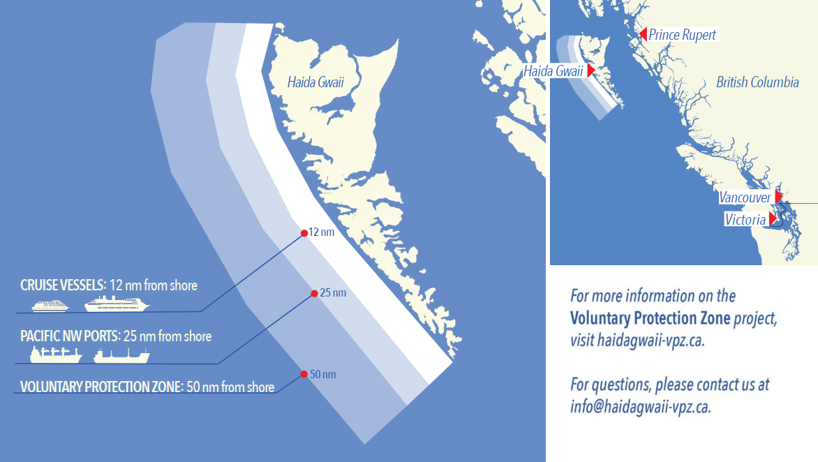
Voluntary Protection Zone for Shipping, West Coast Haida Gwaii (formerly Queen Charlotte Islands)
Haida Gwaii’s remote location, rugged coastline, variable sea
and weather conditions, and rich ecological and cultural
heritage make it vulnerable to the potential for pollution from
shipping breakdowns and accidents. Increasing the distance
vessels travel offshore can increase the amount of time
available to address propulsion, steering or other issues, and
the likelihood of a towing vessel being able to respond to a
vessel that is disabled or drifting. This in turn reduces the
risk of grounding and oil spills.
A Voluntary Protection Zone for Shipping on the West Coast of
Haida Gwaii is currently in effect. In the Voluntary
Protection Zone, commercial vessels of 500 gross tonnage or
greater shall observe a minimum distance of 50 nautical miles
offshore when transiting along the West Coast of Haida Gwaii
with the following exceptions:
–Cruise vessels, to observe a minimum 12 nm distance from shore;
–Vessels transiting between Pacific Northwest ports
(Washington, Alaska, BC), to observe a minimum 25 nm distance
from shore;
–Tugs and barges (including pushing and towing
alongside), no minimum distance; and
–Fishing vessels, no minimum distance.
The Voluntary Protection Zone for Shipping coordinates are:
|
54⁰ 15.436' N |
133⁰ 04.788' W |
|
54⁰ 17.572' N |
134⁰ 02.484' W |
|
54⁰ 13.614' N |
134⁰ 19.427' W |
|
54⁰ 11.786' N |
134⁰ 30.841' W |
|
53⁰ 44.036' N |
134⁰ 32.677' W |
|
53⁰ 11.118' N |
134⁰ 16.412' W |
|
52⁰ 18.483' N |
133⁰ 20.917' W |
|
51⁰ 24.590' N |
132⁰ 04.081' W |
|
51⁰ 56.158' N |
131⁰ 01.830' W |
Vessels are requested to adhere to these distances on a voluntary basis and only when it does not jeopardize the safety of navigation, the vessel, the persons aboard, and the cargo.
(NW-P-1085-20)
*905/22Transport Canada – British Columbia North Coast Waterway Management Guidelines
(Recurrent publication of notice *905/22, originally published in the Notices to Mariners – Monthly Western Edition 09/2022 publication.)
The North Coast Waterway Management Guidelines are voluntary guidelines that aim to improve safety on the water by reducing conflicts between First Nations’ marine use activities, such as fishing and shoreline harvesting, and commercial vessels on the shipping route between Kitimat and Browning Entrance. The guidelines came into effect on September 1, 2022, and will be reviewed from time to time.
The guidelines apply to all vessels navigating on the route between Kitimat and Browning Entrance, on the north coast of British Columbia. This area includes:
|
•Douglas Channel |
•Otter Channel |
|
•Wright Sound |
•Nepean Sound, and |
|
•Lewis Passage |
•Principe Channel |

The complete guidelines document is available at the following link:
Nothing in these guidelines replaces or changes how we apply any Canadian or international laws or regulations, including the Collision Regulations. Furthermore, nothing in these guidelines prevents or limits the master or pilot of a ship from making any decisions to protect the vessel, the crew, or the marine environment.
The guidelines include information for:
•all vessels that covers:
-inshore safety zones
-routing measures
-speed reductions
-guidelines for meeting and passing
-a special operating area in Wright Sound, and
-guidelines in case of a mechanical or electrical breakdown
•large commercial ships, including bulk carriers,
general cargo vessels, liquid bulk vessels, and passenger
vessels
•tugs and barges, and
•vessels operating in First Nations Areas of Concern where you must pay special attention to make sure local community users can transit and use the area safely.
*204/23Canadian Coast Guard – Cessation of Rectangular Broadcasting in NAVAREA / METAREAs XVII and XVIII
(Recurrent publication of notice *204/23, originally published in the Notices to Mariners – Monthly Western Edition 02/2023 publication.)
Since 2010, the five Arctic NAVAREA/METAREAs have promulgated warnings and forecasts to their areas of responsibility using INMARSAT-C’s rectangular area addressing capability. At that time, it was not possible to code older Inmarsat-C receivers to receive warnings and forecasts directly addressed to the Arctic NAVAREA/METAREAs.
All Inmarsat-C and Mini-C receivers available for purchase today are able to receive warnings and forecasts addressed to the Arctic NAVAREA/METAREAs, and have been for more than a decade.
Effective on January 1st, 2024, the Arctic NAVAREA/METAREAs will commence broadcasting their warnings and forecasts using their unique numeric identifier and will cease using rectangular addressing.
During 2023, the Arctic NAVAREA/METAREAs will transmit test messages using the numeric NAVAREA/METAREA identifier to allow mariners to verify reception on their Inmarsat-C or Mini-C receivers.
Mariners navigating in Arctic waters must ensure that their Inmarsat-C or Mini-C receiver detects the new encoding prior to January 1st, 2024 to continue receiving Arctic NAVAREA/METAREA warnings and forecasts.
*205/23Vancouver Fraser Port Authority – Anchorage Code of Conduct
(Recurrent publication of notice *205/23, originally published in the Notices to Mariners – Monthly Western Edition 02/2023 publication.)
Purpose of the Code of Conduct:
–The objective of the anchorage code of conduct is to promote enhanced ship safety and environmental protection, while also reducing the effects of ship movements on local communities. Anchorages in Southern British Columbia lie in significantly eco-sensitive coastal waters and have the potential to affect the quality of life for neighbouring coastal and Indigenous communities unless strict mitigations, including the minimization of noise and light pollution, are taken.
–The anchorage code of conduct applies to all anchorages assigned and managed by the Vancouver Fraser Port Authority, and shall apply at all times, except when instructed by the port authority or the Canadian Coast Guard, and in emergencies when it is the responsibility of the Master to take any and all action to ensure safety of their vessel consistent with the prevailing circumstances and conditions.
Accessing the anchorage code of conduct:
–The code of conduct applies to all anchorages assigned by the Vancouver Fraser Port Authority both within the Port of Vancouver and the Southern Gulf Islands.
–The code of conduct is accessed via the Vancouver Fraser Port Authority’s Port Information Guide available at https://www.portvancouver.com/marine-operations/.
*310/23Canadian Coast Guard – Differential Global Positioning System (DGPS) in Canada
(Recurrent publication of notice *310/23, originally published in the Notices to Mariners – Monthly Western Edition 03/2023 publication.)
Reference: Notice *1206/22 is cancelled.
On December 15th, 2022, the Canadian Coast Guard (CCG) permanently discontinued the provision of its DGPS service across Canada.
Today’s GPS meets the needs of international Position, Navigation and Timing (PNT) requirements for maritime navigation. Further, for mariners in Canadian waters, there is no carriage requirement for ground - or space - based augmentation capability onboard vessels for Global Navigation Satellite Systems (GNSS).
Mariners should note that CCG DGPS sites may broadcast corrections on occasion for technology testing. During these testing, the DGPS corrections broadcasted should not be considered reliable for marine navigation.
*402/23Canadian Hydrographic Service – Nautical Charts
|
Charts |
Main Title |
Scale |
Edition Date |
Published |
Cat# |
Price |
|
New Editions |
||||||
|
3668 |
Alberni Inlet |
1:40 000 |
2023-03-10 |
2023-04-21 |
2 |
$20.00 |
*403/23Canadian Hydrographic Service – Electronic Navigational Charts
|
S-57 ENC Number |
Chart Title |
ENC Compilation Scale |
Published |
|
New Charts |
|||
|
CA4AW1TA (Edn 1.000) |
CA4AW1TA |
1:90 000 |
2023-04-21 |
|
CA4B717A (Edn 1.000) |
CA4B717A |
1:90 000 |
2023-04-21 |
|
CA4B71HA (Edn 1.000) |
CA4B71HA |
1:90 000 |
2023-04-21 |
|
CA4B71TA (Edn 1.000) |
CA4B71TA |
1:90 000 |
2023-04-21 |
|
CA4B724A (Edn 1.000) |
CA4B724A |
1:90 000 |
2023-04-21 |
|
CA4B72EA (Edn 1.000) |
CA4B72EA |
1:90 000 |
2023-04-21 |
|
CA4B72QA (Edn 1.000) |
CA4B72QA |
1:90 000 |
2023-04-21 |
|
CA4B731A (Edn 1.000) |
CA4B731A |
1:90 000 |
2023-04-21 |
|
CA4B73BA (Edn 1.000) |
CA4B73BA |
1:90 000 |
2023-04-21 |
|
CA4B73MA (Edn 1.000) |
CA4B73MA |
1:90 000 |
2023-04-21 |
|
CA4B73XA (Edn 1.000) |
CA4B73XA |
1:90 000 |
2023-04-21 |
|
CA4B748A (Edn 1.000) |
CA4B748A |
1:90 000 |
2023-04-21 |
|
CA4B74JA (Edn 1.000) |
CA4B74JA |
1:90 000 |
2023-04-21 |
|
CA4BH2QA (Edn 1.000) |
CA4BH2QA |
1:90 000 |
2023-04-21 |
|
CA4BH31A (Edn 1.000) |
CA4BH31A |
1:90 000 |
2023-04-21 |
|
CA4BH3BA (Edn 1.000) |
CA4BH3BA |
1:90 000 |
2023-04-21 |
|
CA4BH3MA (Edn 1.000) |
CA4BH3MA |
1:90 000 |
2023-04-21 |
|
CA4BH3XA (Edn 1.000) |
CA4BH3XA |
1:90 000 |
2023-04-21 |
|
CA4BH48A (Edn 1.000) |
CA4BH48A |
1:90 000 |
2023-04-21 |
|
CA4BH4JA (Edn 1.000) |
CA4BH4JA |
1:90 000 |
2023-04-21 |
|
CA4BH4UA (Edn 1.000) |
CA4BH4UA |
1:90 000 |
2023-04-21 |
|
CA4BH55A (Edn 1.000) |
CA4BH55A |
1:90 000 |
2023-04-21 |
|
CA4BH5FA (Edn 1.000) |
CA4BH5FA |
1:90 000 |
2023-04-21 |
|
CA4BH5RA (Edn 1.000) |
CA4BH5RA |
1:90 000 |
2023-04-21 |
|
CA4BH62A (Edn 1.000) |
CA4BH62A |
1:90 000 |
2023-04-21 |
|
CA670764 (Edn 1.000) |
Sointula Ferry Terminal |
1:1 000 |
2023-04-28 |
|
New Editions |
|||
|
CA376011 (Edn 12.000) |
Approaches to Saint John / Approches à Saint John |
1:30 000 |
2023-04-21 |
|
CA376014 (Edn 9.000) |
Cape Sable Island to/aux Tusket Islands |
1:30 000 |
2023-04-28 |
|
CA376018 (Edn 8.000) |
Tusket Islands to/à Cape St. Marys |
1:30 000 |
2023-04-28 |
|
CA376044 (Edn 5.000) |
Little Hope Island to/à Cape St Marys |
1:75 000 |
2023-04-28 |
|
CA376045 (Edn 6.000) |
Liverpool Harbour to/à Lockeport Harbour |
1:30 000 |
2023-04-28 |
|
CA376047 (Edn 8.000) |
Lockeport to/à Cape Sable |
1:30 000 |
2023-04-28 |
|
CA376061 (Edn 8.000) |
Country Harbour to/à Ship Harbour |
1:75 000 |
2023-04-07 |
|
CA376120 (Edn 7.000) |
Conception Bay |
1:30 000 |
2023-04-07 |
|
CA376137 (Edn 9.000) |
Sable Island/Île de Sable, Western Portion/Partie Ouest |
1:50 000 |
2023-04-07 |
|
CA376153 (Edn 4.000) |
Trinity Bay - Southern Portion/Partie Sud |
1:30 000 |
2023-04-21 |
|
CA376164 (Edn 9.000) |
Burin Peninsula to Saint-Pierre |
1:37 500 |
2023-04-14 |
|
CA376167 (Edn 7.000) |
Cape Smoky to St. Paul Island |
1:37 500 |
2023-04-21 |
|
CA376230 (Edn 7.000) |
Cape Canso to Liscomb Island |
1:54 418 |
2023-04-21 |
|
CA376289 (Edn 8.000) |
Sable Island/Île de Sable |
1:50 000 |
2023-04-07 |
|
CA379140 (Edn 5.000) |
Baie Washtawouka à/to Baie Piashti |
1:34 975 |
2023-04-14 |
|
CA470075 (Edn 13.000) |
Race Rocks to/à D'Arcy Island |
1:20 000 |
2023-04-21 |
|
CA470167 (Edn 6.000) |
Alberni Inlet |
1:20 000 |
2023-04-07 |
|
CA471021 (Edn 3.000) |
Atli Inlet |
1:180 000 |
2023-04-14 |
|
CA471022 (Edn 3.000) |
SkinCuttle Inlet |
1:180 000 |
2023-04-14 |
|
CA471023 (Edn 2.000) |
Kunghit Island |
1:180 000 |
2023-04-14 |
|
CA473229 (Edn 8.000) |
Killarney to/à Little Current |
1:20 000 |
2023-04-21 |
|
CA476664 (Edn 4.000) |
Pearl Island to/à Cape La Have |
1:19 511 |
2023-04-28 |
|
CA570073 (Edn 13.000) |
Vancouver Harbour Western Portion/Partie Ouest |
1:5 000 |
2023-04-07 |
|
CA571037 (Edn 2.000) |
Shields Bay (Part 1 of 3) |
1:11 000 |
2023-04-21 |
|
CA571038 (Edn 2.000) |
Shields Bay (Part 2 of 3) |
1:11 000 |
2023-04-21 |
|
CA571039 (Edn 2.000) |
Shields Bay (Part 3 of 3) |
1:11 000 |
2023-04-21 |
|
CA573307 (Edn 5.000) |
Little Current |
1:7 500 |
2023-04-21 |
|
Charts Permanently Withdrawn |
|||
|
CA476027 |
Grand Passage |
Cancelled by CA376024 |
|
|
CA476028 |
Petit Passage |
Cancelled by CA376024 |
|
|
CA476220 |
Carrington Island to Etagaulet Bay |
|
|
|
CA476405 |
Harbour Grace and/et Carbonear |
Cancelled by CA376120 |
|
*404/23Canadian Hydrographic Service – Raster Digital Charts (BSB V3)
|
Charts |
Main Title |
Scale |
Edition Date |
Published |
|
New Editions |
||||
|
RM-3668 |
Alberni Inlet |
1:40 000 |
2023-03-10 |
|
*405/23Transport Canada – Ship Safety Bulletins #03, #04 and #05/2023
New Ship Safety Bulletins have recently been posted on the Transport Canada website.
To view or download these bulletins, please click on the link below:
SSB#03/2023 – United Kingdom
seafarers can now seek Canadian recognition of their STCW
certificates
RDIMS#
19248898
SSB#04/2023 – Filipino seafarers
can now seek Canadian recognition of their STCW
certificates
RDIMS#
19378913
SSB#05/2023 – Protecting the
North Atlantic right whale: speed restriction measures in the
Gulf of St.
Lawrence
RDIMS#
18265176
Sign up for e-Bulletin to receive an e-mail notice each time a new Ship Safety Bulletin is published on our website.
Contact us at marinesafety-securitemaritime@tc.gc.ca or 1-855-859-3123 (Toll Free).
*406/23Canadian Coast Guard Publication – Amendments to Notices to Mariners Annual Edition 2023 - Section A6, Notice 14: Canadian Nautical Charts and Publications and International Publications
Starting from page 1
AMEND AS FOLLOWS
Canadian nautical charts and publications are available from authorized Canadian Hydrographic Service (CHS) Chart Dealers. For a complete list of authorized dealers, visit https://www.charts.gc.ca/charts-cartes/dealer-depositaire-eng.html. Alternatively, please contact the CHS Sales and Distribution office:
|
Canadian Hydrographic Service |
|
CHS Item # |
Title |
|
|
Nautical Charts |
|
|
|
|
|
Sailing Directions |
|
|
|
|
|
|
|
|
|
|
|
|
|
|
|
|
|
|
|
|
|
|
|
|
|
|
|
|
|
|
|
|
|
|
|
|
|
|
|
|
|
|
|
|
|
|
|
|
|
|
|
|
|
|
|
|
|
|
|
|
|
|
|
|
|
|
|
|
|
|
|
|
|
|
|
|
|
|
|
|
|
|
|
|
|
|
|
|
|
|
|
|
|
|
|
|
|
|
|
|
|
|
|
|
|
|
|
|
|
|
|
|
|
|
|
|
|
|
|
|
|
|
|
|
|
|
|
|
|
|
|
|
|
|
|
|
|
|
|
|
|
|
|
|
|
|
|
|
|
|
|
|
|
|
|
|
|
|
|
|
|
|
|
|
|
|
|
|
|
|
|
|
|
|
|
|
|
|
|
|
|
|
|
|
|
|
|
|
|
|
|
|
|
|
|
Page 4
AMEND AS FOLLOWS
|
List |
Title |
Price |
|
IV |
List of Coast Stations and Special Service
Stations, |
213 CHF |
|
V |
List of Ship Stations and Maritime Mobile Service
Identity Assignments, |
322 CHF |
|
|
Manual for Use by the Maritime Mobile and |
295 CHF |
Page 5
AMEND AS FOLLOWS
Since April 1st, 2013, in an effort to adopt and
focus on newer technologies, the Canadian Coast Guard (CCG)
ceased the printing of its List of Lights book, Annual
Edition of the Notices to Mariners and also the Radio Aids to
Marine Navigation Annual Publication. For complete details,
please visit the following page: https://www.notmar.gc.ca.
AUTHORIZED DEALERS - CANADIAN HYDROGRAPHIC SERVICE
The authorized dealers at major Canadian and Foreign seaports stock Canadian charts and publications necessary for commercial shipping in their districts. For a complete list of authorized dealers, visit http://www.charts.gc.ca/charts-cartes/dealer-depositaire-eng.html
|
Canadian Hydrographic Service |
Section 1A: Temporary and Preliminary Notices
Reminder – Comment Period for Active Preliminary Notices
This is a reminder that the comment period is still open for the following active Preliminary notices:
|
Notice # |
Reference Chart # |
Aids Affected |
Intent of Notice |
|
Pacific Coast |
|||
|
3053 |
5686 |
Daybeacon to be Discontinued |
|
Please refer to the Notices to Mariners - Monthly Summary of Temporary and Preliminary Notices publication for details.
Inland Waters
Temporary Notices
No notices applicable for this edition.
Preliminary Notices
No notices applicable for this edition.
Pacific Coast
Temporary Notices
No notices applicable for this edition.
Preliminary Notices
No notices applicable for this edition.
SECTION 2 - CHART CORRECTIONS
3419 - Esquimalt Harbour - New Edition - 13-DEC-2013 - World Geodetic System 1984
(See Chart 1, Q40)
(See Chart 1, Q40)
(See Chart 1, Q40)
(See Chart 1, Q40)
(See Chart 1, Q40)
(See Chart 1, Q40)
3424 - Approaches to/Approches à Oak Bay - New Edition - 12-SEP-2003 - NAD 1983
(See Chart 1, P2)
3440 - Race Rocks to/à D'Arcy Island - New Edition - 01-JUL-2005 - NAD 1983
(See Chart 1, P2)
3546 - Broughton Strait - New Edition - 15-APR-2005 - NAD 1983
Download Patch - https://www.notmar.gc.ca/chsftp/patches/3546_6204748_1_202303201202.pdf
3550 - Approaches to/Approches à Seymour Inlet and/et Belize Inlet - New Chart - 03-DEC-1993 - NAD 1983
(See Chart 1, K26)
3598 - Cape Scott to Cape Calvert - New Edition - 11-NOV-2016 - NAD 1983
(See Chart 1, K26)
3605 - Quatsino Sound to/à Queen Charlotte Strait - New Edition - 06-MAR-1998 - NAD 1983
(See Chart 1, K26)
3958 - Prince Rupert Harbour - New Edition - 13-DEC-2013 - World Geodetic System 1984
(See Chart 1, K12)
3964 - Tuck Inlet - New Edition - 30-APR-1999 - NAD 1983
(See Chart 1, K12)
6258 - Montreal Point to/à Kettle Island - Sheet/Feuille 1 - New Chart - 30-DEC-1988 - NAD 1983
(See Chart 1, Q120)
(See Chart 1, Q120)
(See Chart 1, Q120)
(See Chart 1, Q120)
(See Chart 1, Q120)
(See Chart 1, Q120)
SECTION 3 - RADIO AIDS TO MARINE NAVIGATION CORRECTIONS
*417/23Radio Aids to Marine Navigation 2023 (Atlantic, St. Lawrence, Great Lakes, Lake Winnipeg, Arctic and Pacific)
Page 1-2
ADD AS FOLLOWS:
1.1.4New Electronic Form for Western Canada VTS Offshore Advanced Reporting
Prince Rupert MCTS is now accepting VTS Offshore Zone Reports (RAMN 3.8.1 refers) using the Microsoft Excel form available at: https://navigation-electronique.canada.ca/topics/traffic/cvms/vtsoffshore-en This report shall be submitted directly to Prince Rupert MCTS by email at vts.rupert@innav.gc.ca or to the nearest CCG MCTS Centre.
For accuracy, please ensure that reports are completed using the correct version of the report form before submitting to Prince Rupert MCTS. The latest version of the report can be downloaded from the website noted above.
Page 1-11
AMEND AS FOLLOWS:
Arctic Region
Service available in English.
Regional Superintendent
Marine Communications and Traffic Services
Canadian Coast Guard
301-5204 50th Avenue
Yellowknife, NT X1A 1E2
Telephone:
519-330-6547 867-444-0109
Page 2-8
DELETE THE FOLLOWING TABLE:
Table 2-4 - Iqaluit MCTS/VFF – Broadcasts
REPLACE WITH:
Table 2-4 - Iqaluit MCTS/VFF – Broadcasts
|
Time UTC |
Site |
Frequency or Channel |
Contents |
|
01:10 |
Coral Harbour |
2514J3E |
Radiotelephony
•Technical
marine synopsis and forecasts for marine forecast areas
155, 156, 157, 158, 162, 163, 311 and 312. •Navigational warnings “Series A” for all NORDREG waters bound by Shipping Safety Control Zones 8, 14 and 16, including Southern Hudson Bay, James Bay, Chesterfield Inlet and Baker Lake. |
|
Coral Harbour |
6507J3E |
||
|
01:15 |
Inuvik |
6218.6J3E |
Radiotelephony
•Technical
marine synopsis for Western Arctic waters (if
applicable for Mackenzie River and Great Slave Lake
area). •Navigational warnings “Series H and A” for Great Slave Lake, Hay River, Mackenzie River and Mackenzie Delta bound by forecast areas 112 and 113. |
|
Hay River |
4363J3E |
||
|
Parson’s Lake and Enterprise |
Ch26 |
||
|
Yellowknife |
Ch85 |
||
|
02:35 |
Cambridge Bay |
4363J3E |
Radiotelephony
•Technical
marine synopsis for Western Arctic waters. •Navigational warnings “Series A” for all NORDREG waters west of Taloyoak. |
|
Inuvik |
6218.6J3E |
||
|
03:00 |
Iqaluit |
490F1B |
NAVTEX: (S) French •Weather for marine forecast areas 143, 144, 145, 147, 148, 149 and 150. |
|
03:10 |
Iqaluit |
518F1B |
NAVTEX: (T) English •Weather for marine forecast areas 143, 144, 145, 147, 148, 149 and 150. |
|
03:30 |
Iqaluit |
8416.5F1B |
HF NBDP •METAREA bulletins for METAREAS XVII and XVIII within Canadian waters. •NAVAREA warnings for NAVAREAs XVII and XVIII. |
|
07:00 |
Iqaluit |
490F1B |
NAVTEX: (S) French •Navigational warnings “Series A” for NORDREG waters bound by marine forecast areas 143, 144, 145, 147, 148, 149 and 150. •Ice hazard bulletin for marine forecast areas 143, 144, 145, 147, 148, 149 and 150. |
|
07:10 |
Iqaluit |
518F1B |
NAVTEX: (T) English •Navigational warnings for “Series A” for NORDREG waters bound by marine forecast areas 143, 144, 145, 147, 148, 149 and 150. •Ice hazard bulletin for marine forecast areas 143, 144, 145, 147, 148, 149 and 150. |
|
11:00 |
Iqaluit |
490F1B |
NAVTEX: (S) French •Weather for marine forecast areas 143, 144, 145, 147, 148, 149 and 150. |
|
11:10 |
Iqaluit |
518F1B |
NAVTEX: (T) English •Weather for marine forecast areas 143, 144, 145, 147, 148, 149 and 150. |
|
12:40 |
Resolute |
2582J3E |
Radiotelephony •Technical marine synopsis and forecasts for marine forecast areas 125, 135, 136, 137 and 138. •Navigational warnings “A Series” for all NORDREG waters bound by Shipping Safety Control Zones 1, 2, 3, 5, 6, 9 and 13. |
|
Resolute |
4363J3E |
||
|
13:15 |
Inuvik |
6218.6J3E |
Radiotelephony
•Technical
marine synopsis for Western Arctic waters (if
applicable for Mackenzie River and Great Slave Lake
area). •Navigational warnings “Series H and A” for Great Slave Lake, Hay River, Mackenzie River and Mackenzie Delta bound by forecast areas 112 and 113. |
|
Hay River |
4363J3E |
||
|
Parson’s Lake and Enterprise |
Ch26 |
||
|
Yellowknife |
Ch85 |
||
|
13:20 |
Coral Harbour |
2514J3E |
Radiotelephony
•Technical
marine synopsis and forecasts for marine forecast areas
155, 156, 157, 158, 162, 163, 311 and 312. •Navigational warnings “A Series” for all NORDREG waters bound by Shipping Safety Control Zones 8, 14, 16 and including, Southern Hudson Bay, James Bay, Chesterfield Inlet and Baker Lake. |
|
Coral Harbour |
6507J3E |
||
|
14:10 |
Killinek |
2514J3E |
Radiotelephony
•Technical
marine synopsis and forecasts for marine forecast
areas: 139 to 150, 228, 229 and 230. •Navigational warnings “A Series” and relevant “N Series” for all NORDREG waters bound by Shipping Safety Control Zones 9, 10 and 15, including Ungava Bay and along the Labrador coast southward to 58N. |
|
Iqaluit |
2582J3E |
||
|
Iqaluit |
4363J3E |
||
|
Iqaluit |
6507J3E |
||
|
14:35 |
Cambridge Bay |
4363J3E |
Radiotelephony
•Technical
marine synopsis for Western Arctic waters. •Navigational warnings “A Series” for all NORDREG waters west of Taloyoak. |
|
Inuvik |
6218.6J3E |
||
|
15:00 |
Iqaluit |
490F1B |
NAVTEX: (S) French •Weather for marine forecast areas 143, 144, 145, 147, 148, 149 and 150. |
|
15:10 |
Iqaluit |
518F1B |
NAVTEX: (T) English •Weather for marine forecast areas 143, 144, 145, 147, 148, 149 and 150. |
|
15:30 |
Iqaluit |
8416.5F1B |
HF NBDP •METAREA bulletins for METAREAS XVII and XVIII within Canadian waters. •NAVAREA warnings for NAVAREAS XVII and XVIII. |
|
17:05 |
Cambridge Bay |
4363J3E |
Radiotelephony •Ice boundary information. •Ice forecasts for marine forecast areas 111 to 122 and 125, 135, 136, 137, 138, 139, 140, 141, 142, 144, 145, 146, 147, 148, 149, 150, 155, 156, 157, 158, 162, 163, 228, 229, 230, 311 and 312 for Hudson Bay and Foxe Basin. |
|
Inuvik |
6218.6J3E |
||
|
Coral Harbour / |
2514J3E |
||
|
Iqaluit / |
2582J3E |
||
|
Iqaluit / |
4363J3E |
||
|
Coral Harbour / |
6507J3E |
||
|
19:00 |
Iqaluit |
490F1B |
NAVTEX: (S) French •Navigational warnings “A Series” for NORDREG waters bound by marine forecast areas 143, 144, 145, 147, 148, 149 and 150. •Ice hazard bulletin for marine forecast areas 143, 144, 145, 147, 148, 149 and 150. |
|
19:10 |
Iqaluit |
518F1B |
NAVTEX: (T) English •Navigational warnings “A Series” for NORDREG waters bound by marine forecast areas 143, 144, 145, 147, 148, 149 and 150. •Ice hazard bulletin for marine forecast areas 143, 144, 145, 147, 148, 149 and 150. |
|
22:35 |
Killinek |
2514J3E |
Radiotelephony
•Technical
marine synopsis and forecasts for marine forecast areas
139 to 150, 228, 229 and 230. •Navigational warnings “A Series” and relevant “N Series” for all NORDREG waters bound by Shipping Safety Control Zones 9, 10 and 15, including Ungava Bay and along the Labrador coast southward to 58N. |
|
Iqaluit |
2582J3E |
||
|
Iqaluit |
4363J3E |
||
|
Iqaluit |
6507J3E |
||
|
23:00 |
Iqaluit |
490F1B |
NAVTEX: (S) French •Weather for marine forecast areas 143, 144, 145, 147, 148, 149 and 150. |
|
23:10 |
Iqaluit |
518F1B |
NAVTEX: (T) English •Weather for marine forecast areas 143, 144, 145, 147, 148, 149 and 150. |
|
23:10 |
Resolute |
2582J3E |
Radiotelephony •Technical marine synopsis and forecasts for marine forecast areas 125, 135, 136, 137 and 138. •Navigational warnings “A Series” for all NORDREG waters bound by Shipping Safety Control Zones 1, 2, 3, 5, 6, 9 and 13. |
Page 3-13
ADD AS FOLLOWS:
3.8.1VTS Offshore Zone Report
The VTS Offshore report shall be completed using the electronic form available at https://navigation-electronique.canada.ca/topics/traffic/cvms/vtsoffshore-en. The VTS Offshore report shall be communicated directly to Prince Rupert MCTS Centre at vts.rupert@innav.gc.ca or to the nearest CCG MCTS Centre.
Page 4-43
ADD AS FOLLOWS:
4.2.9Reporting Marine Occurrences to Transportation Safety Board (TSB)
Pursuant to the Canadian Transportation Accident Investigation and Safety Board Act, the Transportation Safety Board Regulations require that the person responsible for the ship (e.g. owner, operator, charterer, master, pilot, crew member) in Canadian waters, or a Canadian ship in any waters, report a marine occurrence as soon as possible and by the quickest means available to TSB. The following alternatives to reporting to TSB are deemed acceptable: a Marine Communications and Traffic Services (MCTS) Centre; a marine radio station operated by the St. Lawrence Seaway Management Corporation; or, a Canadian harbour radio station.
Persons responsible for ships are reminded that penalties may be incurred by failing to report a marine occurrence. A marine occurrence shall also be reported in writing, within 30 days following the marine occurrence, by completing the “REPORT OF A MARINE OCCURRENCE/HAZARDOUS OCCURRENCE REPORT” also available from the TSB website.
Please contact the following appropriate TSB Regional office to:
a)Submit TSB form REPORT OF A MARINE OCCURRENCE/HAZARDOUS OCCURRENCE REPORT;
b)Contact a TSB Regional Standby officer; or,
c)Make general inquiries.
Telephone (24/7): 902-471-0820
Facsimile: 819-997-2239
Email: MarineNotifications.Atlantic@tbs-bst.gc.ca
Address: 150 Thorne Avenue, Dartmouth, NS B3B 1Z2
Telephone (24/7): 418-580-3510
Facsimile: 819-997-2239
Email: MarineNotifications.Central@tsb-bst.gc.ca
Address: 2575 Ste-Anne Blvd, Suite 220, Québec, QC G1J 0G7
Telephone (24/7): 604-219-2414
Facsimile: 819-997-2239
Email: MarineNotifications.Pacific@tsb-bst.gc.ca
Address: #4-3071 Number Five Road, Richmond, BC V6X 2T4
Please note: workplace injuries on board vessels must also be reported directly to Transport Canada.
SECTION 4 - CANADIAN SAILING DIRECTIONS CORRECTIONS
The following Canadian Sailing Directions volumes have recently been updated on the Canadian Hydrographic Service website.
|
No. |
Title |
|
Pacific Coast |
|
|
PAC201 |
Juan de Fuca Strait and Strait of Georgia |
|
PAC202 |
Discovery Passage to Queen Charlotte Strait and West Coast of Vancouver Island |
Each volume includes a section entitled “Record of Changes” which lists all updates that are incorporated during the current calendar year.
SECTION 5 - LIST OF LIGHTS, BUOYS AND FOG SIGNALS CORRECTIONS
The amendments are highlighted and deletions are crossed out. For general and region-specific
information on the List of Lights, click on the following links:
Newfoundland and Labrador Coast,
Atlantic Coast,
Inland Waters and
Pacific Coast.
PACIFIC COAST
| No. | Name |
Position ----- Latitude N. Longitude W. |
Light Characteristics |
Focal Height in m. above water |
Nominal Range |
Description ----- Height in meters above ground |
Remarks ----- Fog Signals |
|||
|---|---|---|---|---|---|---|---|---|---|---|
FRASER RIVER - SOUTH ARM (LL 310 - 371) |
||||||||||
|
348.3 G5413.25 |
Deas Slough |
Entrance to dredged cut. 49 06 54.5 123 04 55.8 |
Fl | R | 4s | 7.2 | 4 | White square skeleton tower on single pile dolphin with red band at top. |
Radar reflector. Year round. Chart:3490 Edn 04/23 (P22-033) |
|
JOHNSTONE STRAIT (LL 518 – 544.6) |
||||||||||
|
544 G5613 |
Boat Bay |
W. of bay. 50 31 10.2 126 34 41.8 |
Q | W | 1s | 10.7 | 6 | White square skeleton tower. |
Obscured by land from 277°
through N. to 102°. Year round. Chart:3545 Edn 04/23 (P23-007) |
|
|
544.6 G5613.6 |
Parson Island |
On drying rock. 50 34 30.7 126 40 59.9 |
Q | R | 1s | 6.0 | 7 | White square skeleton tower with red band at top. |
Radar reflector. Year round. Chart:3546 Edn 04/23 (P23-008) |
|
BROUGHTON STRAIT (LL 545 – 553.5) |
||||||||||
|
545 G5614 |
Blinkhorn Peninsula |
On peninsula. 50 32 37.5 126 46 57.1 |
Fl(3) | G | 12s | 9.5 | 6 | White square skeleton tower with green band at top. |
Flash 0.5 s; eclipse 2 s; flash 0.5 s; eclipse 2 s; flash 0.5 s; eclipse 6.5 s. Year round. Chart:3546 Edn 04/23 (P23-009) |
|
|
550.9 G5625.4 |
Broad Point West (Hyde Creek) Sector |
S. of Haddington Island. 50 34 58.2 127 01 24.4 |
F |
R W G |
..... | 6.7 | 5 | White square skeleton tower with red bands at the top and bottom. |
Green from 155° to 158°30’; white from 158°30’ to 163°; red from 163° to 166°30’. Radar reflector. Year round. Chart:3546 Edn 04/23 (P23-014) |
|
QUEEN CHARLOTTE STRAIT (LL 554 – 569) |
||||||||||
|
556 G5628.6 |
Wedge Island |
On island, entrance to Knight Inlet. 50 38 04.8 126 43 20.6 |
Q | W | 1s | 11.1 | 6 | White square skeleton tower. |
Visible from 249°
through W., N., and E. to 106°. Radar reflector. Year round. Chart:3546 Edn 04/23 (P23-022) |
|
|
559 G5629.2 |
James Point |
On point, W. side of entrance to Wells Passage. 50 50 18.5 126 58 42.0 |
Fl | W | 4s | 8.4 | 6 | White square skeleton tower. |
Year round. Chart:3547 Edn 04/23 (P23-023) |
|
|
559.5 G5629.6 |
Numas Islands |
SE. part of island. 50 45 55.3 127 04 17.6 |
Q | W | 1s | 7.1 | 8 | White square skeleton tower. |
Year round. Chart:3547 Edn 04/23 (P23-024) |
|
QUEEN CHARLOTTE SOUND (LL 569.2 – 586) |
||||||||||
|
569.3 G5647.4 |
Tribune Rock |
On rock. 50 51 27.5 127 33 58.9 |
Fl | G | 4s | 7.6 | 6 | White square skeleton tower with green band at top. |
Radar reflector. Year round. Chart:3549 Edn 04/23 (P23-017) |
|
|
577 G5655 |
McEwan Rock |
On rock. 51 03 31.6 127 37 54.2 |
Fl(3) | W | 12s | 21.6 | 6 | White square skeleton tower. |
Flash 0.5 s; eclipse 2 s; flash 0.5 s; eclipse 2 s; flash 0.5 s; eclipse 6.5 s. Year round. Chart:3550 Edn 04/23 (P23-027) |
|
HAIDA GWAII (LL 768.6 – 812) |
||||||||||
|
778 G5835 |
Kingui Island |
On SW. extremity of island. 53 01 27.7 131 37 55.7 |
Fl | W | 6s | 11.6 | 5 | White square skeleton tower. |
Flash 0.5 s; eclipse 5.5 s. Visible from 285° through N. and E. to 157°. Year round. Chart:3894 Edn 04/23 (P22-034) |
|
|
798 G5843 |
Striae Islands |
E. islet of the islands group. 54 05 12.1 132 14 53.1 |
Fl(3) | W | 12s | 8.3 | 6 | White square skeleton tower. |
Flash 0.5 s; eclipse 2 s; flash 0.5 s; eclipse 2 s; flash 0.5 s; eclipse 6.5 s. Year round. Chart:3895 Edn 04/23 (P22-035) |
|
Report a problem on this page
- Date modified: