
Archived information
The Standard on Web Usability replaces this content. This content is archived because Common Look and Feel 2.0 Standards have been rescinded.
Archived information is provided for reference, research or recordkeeping purposes. It is not subject to the Government of Canada Web Standards and has not been altered or updated since it was archived.
Notices to Mariners
March 25, 2022

Safety First, Service Always
Monthly Western Edition
CONTENTS
| Section 1 | General and Safety Information |
| Section 1A | Temporary and Preliminary Notices |
| Section 2 | Chart Corrections |
| Section 3 | Radio Aids to Marine Navigation Corrections |
| Section 4 | Sailing Directions and Small Craft Guide Corrections |
| Section 5 | List of Lights, Buoys and Fog Signals Corrections |
Notices to Mariners – Monthly Western Edition
Edition No. 03/2022
Aussi disponible en français :
Avis aux navigateurs – Édition mensuelle de l’Ouest
Édition n° 03/2022
Published under the Authority of:
Canadian Coast Guard Programs
Aids to Navigation and Waterways
Fisheries and Oceans Canada
Montreal, QC H2Y 2E7
For more information, contact Notmar.XNCR@dfo-mpo.gc.ca.
© Her Majesty the Queen in Right of Canada,
as represented by the Minister of Fisheries, Oceans
and the Canadian Coast Guard, 2022.
Cat. No. Fs152-6E-PDF (Electronic PDF, English)
ISSN 1719-7708
Cat. No. Fs152-6F-PDF (Electronic PDF, French)
ISSN 1719-7716
Explanatory Notes – Notices to Mariners (NOTMAR)
Geographical positions refer directly to the graduations of the largest scale Canadian Hydrographic Service chart (unless otherwise indicated).
Bearings refer to the true compass and are measured clockwise from 000° (North) clockwise to 359°; those relating to lights are from seaward.
Visibility of lights is that in clear weather.
Depths - The units used for soundings (metres, fathoms or feet) are stated in the title of each chart.
Elevations are normally given above Higher High Water, Large Tide (unless otherwise indicated).
Distances may be calculated as follows:
1 nautical mile = 1,852 metres (6,076.1 feet)
1 statute mile = 1,609.3 metres (5,280 feet)
1 metre = 3.28 feet
Temporary and Preliminary Notices to Mariners – Section 1A of Notices to Mariners
These notices are indicated by a (T) or a (P), respectively. Please note that nautical charts are not amended by the Canadian Hydrographic Service for temporary (T) and preliminary (P) notices. It is recommended that mariners chart these corrections in pencil. For the list of charts affected by (T) & (P) notices, please refer to the current Notices to Mariners - Monthly Summary of Temporary and Preliminary Notices publication.
Suggestions and Corrections Form
This form is specifically for suggestions and corrections to Notices to Mariners publications. It is available online and also in fillable PDF format included with the monthly publication ZIP file.
To report chart discrepancies and/or corrections to the Sailing Directions booklets: Fill out the Marine Information Reporting Form and/or email chsinfo@dfo-mpo.gc.ca.
To report emergencies or navigational hazards: Contact your nearest MCTS centre
- VHF channel 16 (156.8 MHz)
- MF/HF frequency 2182 kHz/4125 kHz (where available)
- ∗16 on a cellphone (where available)
NOTMAR Website – Monthly Editions, Chart Corrections and Chart Patches
The NOTMAR website allows users to access the monthly publications,
chart corrections, and chart patches.
Users can subscribe for free to the email notification service
to receive notifications when charts of interest are updated, including their patches, as well as when a new Monthly Edition of Notices to Mariners is published.
In addition, the monthly publication and related
files to download, such as chart patches and Sailing
Directions diagrams, can be obtained all together
through the download of a single ZIP file.
Explanatory Notes – Canadian Hydrographic Service (CHS)
Chart Corrections – Section 2 of Notices to Mariners
Corrections to nautical charts will be listed in numerical order by chart number. Each chart correction listed applies only to that particular chart. Related charts, if any, will have their own specific correction listed separately.
Users should also refer to CHS Chart 1: Symbols, Abbreviations and Terms for additional information pertaining to the correction of charts.
The illustration below describes the elements that will comprise a typical Section 2 chart correction:

The last correction number is identified with the LNM/D or Last Notice to Mariners Number / Date.
Mariners are advised that only the most critical changes that directly affect safety to navigation are issued in “Section 2 – Chart Corrections.” This limitation is required to ensure that charts remain as clear and easy to read as possible. As a result, mariners may see minor discrepancies of a non-critical nature between information in official publications. For example, a small change in the nominal range or focal height of a light may not result in the production of a chart correction in Notices to Mariners, but may result in a correction in the List of Lights, Buoys and Fog Signals publication.
Note: In the case of a discrepancy between information provided on CHS charts relating to aids to navigation, and the List of Lights, Buoys and Fog Signals publication, the latter shall be deemed as containing the most up-to-date information.
Canadian Nautical Charts & Publications
A source list of Canadian nautical charts and publications is published in Notice No. 14 of the Notices to Mariners Annual Edition 2022. The source supply and the prices effective at the time of printing are listed. For current chart edition dates, please refer to the following website: www.chs-shc.gc.ca/charts-cartes/paper-papier/index-eng.asp
Explanatory Notes – Marine Communications and Traffic Services (MCTS)
Navigational Warnings / Notices to Shipping
The Canadian Coast Guard (CCG) is implementing a number of changes to the aids to navigation system in Canada.
These changes are advertised as Navigational Warnings, formerly called Notices to ShippingFootnote 1, that are broadcast by the CCG, and are then followed up with Notices to Mariners, then charts are updated by hand correction, reprints or new editions.
Mariners are advised that all relevant Navigational Warnings (NAVWARN) should be kept until superseded by Notices to Mariners or through revised charts issued by the Canadian Hydrographic Service (CHS).
NAVWARN are accessible on the applicable regional page on the CCG Navigational Warnings website at http://nis.ccg-gcc.gc.ca.
CHS is reviewing the impact of these changes with CCG and together are preparing an action plan on the issuing of chart revisions.
For further information, contact your regional NAVWARN Issuing Desk.
Western Region
Prince Rupert MCTS Centre
Canadian Coast Guard
Bag 4444
Prince Rupert, BC V8J 4K2
Telephone: 250-627-3070
Email: NAVWARN.MCTSPrinceRupert@innav.gc.ca
Website: http://www.marinfo.gc.ca/e-nav
Arctic Region
* Iqaluit MCTS Centre
Operational from approximately mid-May until late December.
Canadian Coast Guard
P.O. Box 189
Iqaluit, NU X0A 0H0
“A” Series
Telephone: 867-979-5269
“H” Series
Telephone: 867-979-0310
Facsimile: 867-979-4264
Email: NAVWARN.MCTSIqaluit@innav.gc.ca
Website: http://www.marinfo.gc.ca/e-nav
* Service available in English and French.
Index
Numerical Index of Canadian Charts Affected
This numerical index lists all nautical charts mentioned in this monthly edition of Notices to Mariners. Only charts appearing in Section 2 of this publication require a chart correction. The appearance of charts in all other sections, particularly those related to the correction of other nautical publications, is included here for reference.
| 1431 | 3534 | 3673 | 6426 |
| 2300 | 3545 | 3674 | 6428 |
| 3000 | 3546 | 3909 | 6432 |
| 3001 | 3547 | 6021 | 7195 |
| 3412 | 3549 | 6370 | 7485 |
| 3513 | 3602 | 6371 | 7621 |
| 3526 | 3603 | 6419 |
SECTION 1 - GENERAL AND SAFETY INFORMATION
Canadian Coast Guard Publication – Comments and Suggestions on Notices to Mariners (NOTMAR) Publications
In an effort to continuously improve the Notices to Mariners publications and to provide the most efficient service possible, the Notices to Mariners team invites all mariners and other interested parties to submit comments and suggestions on possible improvements to its various publications and services at the following email address: Notmar.XNCR@dfo-mpo.gc.ca.
Transport Canada – COVID-19 Measures, Updates and Guidance
(Recurrent publication of notice *401/20, originally published in the Notices to Mariners – Monthly Western Edition 04/2020 publication.)
Please refer to the link below for the latest updates to
transportation related measures taken by Transport Canada in
response to the evolving novel Coronavirus disease
(COVID-19):
https://www.tc.gc.ca/en/initiatives/covid-19-measures-updates-guidance-tc.html.
For travel advice and all other updates, please visit: Canada.ca/coronavirus.
West Coast Haida Gwaii – Voluntary Protection Zone for Shipping
(Recurrent publication of notice *1105/21, originally published in the Notices to Mariners – Monthly Western Edition 11/2021 publication.)
Reference: Notice *903/21 is cancelled.
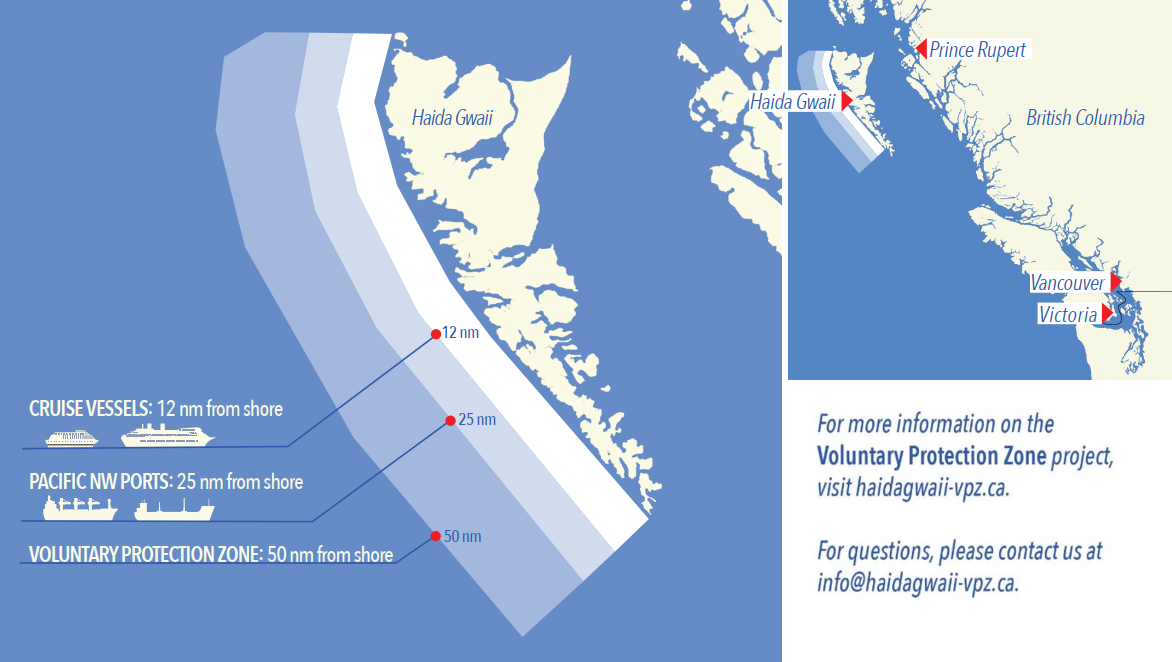
Voluntary Protection Zone for Shipping, West Coast Haida Gwaii (formerly Queen Charlotte Islands)
Haida Gwaii’s remote location, rugged coastline, variable sea
and weather conditions, and rich ecological and cultural
heritage make it vulnerable to the potential for pollution
from shipping breakdowns and accidents. Increasing the
distance vessels travel offshore can increase the amount of
time available to address propulsion, steering or other
issues, and the likelihood of a towing vessel being able to
respond to a vessel that is disabled or drifting. This in
turn reduces the risk of grounding and oil spills.
A Voluntary Protection Zone for Shipping on the West Coast of
Haida Gwaii is currently in effect. In the Voluntary
Protection Zone, commercial vessels of 500 gross tonnage or
greater shall observe a minimum distance of 50 nautical miles
offshore when transiting along the West Coast of Haida Gwaii
with the following exceptions:
–Cruise vessels, to observe a minimum 12 nm distance from shore;
–Vessels transiting between Pacific Northwest ports
(Washington, Alaska, BC), to observe a minimum 25 nm distance
from shore;
–Tugs and barges (including pushing and towing
alongside), no minimum distance; and
–Fishing vessels, no minimum distance.
The Voluntary Protection Zone for Shipping coordinates are:
|
54⁰ 15.436' N |
133⁰ 04.788' W |
|
54⁰ 17.572' N |
134⁰ 02.484' W |
|
54⁰ 13.614' N |
134⁰ 19.427' W |
|
54⁰ 11.786' N |
134⁰ 30.841' W |
|
53⁰ 44.036' N |
134⁰ 32.677' W |
|
53⁰ 11.118' N |
134⁰ 16.412' W |
|
52⁰ 18.483' N |
133⁰ 20.917' W |
|
51⁰ 24.590' N |
132⁰ 04.081' W |
|
51⁰ 56.158' N |
131⁰ 01.830' W |
Vessels are requested to adhere to these distances on a voluntary basis and only when it does not jeopardize the safety of navigation, the vessel, the persons aboard, and the cargo.
(NW-P-1085-20)
Transport Canada – Annual Edition of Notices to Mariners 2022 - Section A3, Notice 7A: Voyage Planning for Vessels Intending to Navigate in Canada's Northern Waters
(Recurrent publication of notice *206/22, originally published in the Notices to Mariners – Monthly Western Edition 02/2022 publication.)
Transport Canada has revised notice 7A, Voyage Planning for Vessels Intending to Navigate in Canada’s Northern Waters, of the Annual Edition of Notices to Mariners to reflect Arctic Shipping Safety and Pollution Prevention Regulations (ASSPPR) and to provide further guidance on voyage planning.
*302/22Canadian Hydrographic Service – Nautical Charts
|
Charts |
Main Title |
Scale |
Published |
Cat# |
Price |
|
New Editions |
|||||
|
1431 |
Canal de Beauharnois |
1:25 000 |
2022-03-25 |
3 |
$20.00 |
|
2300 |
Lake Superior/Lac Supérieur |
1:600 000 |
2022-03-25 |
3 |
$20.00 |
|
7195 |
Kangok Fiord and Approaches/et les Approches |
1:40 000 |
2022-03-11 |
4 |
$20.00 |
|
7485 |
Parry Bay to/au Navy Channel |
1:150 000 |
2022-03-18 |
4 |
$20.00 |
|
7621 |
Amundsen Gulf |
1:500 000 |
2022-03-25 |
4 |
$20.00 |
*303/22Canadian Hydrographic Service – Electronic Navigational Charts
|
S-57 ENC Number |
Chart Title |
ENC Compilation Scale |
Published |
|
New Charts |
|||
|
CA372006 (Edn 1.000) |
Superior Shoal |
1:45 000 |
2022-03-11 |
|
CA372007 (Edn 1.000) |
Ikahuak (Sachs Harbour) |
1:45 000 |
2022-03-11 |
|
CA373533 (Edn 1.000) |
Tanquary Fjord |
1:50 000 |
2022-03-04 |
|
CA373534 (Edn 1.000) |
Glacier Fjord |
1:50 000 |
2022-03-04 |
|
CA471406 (Edn 1.000) |
Kootenay Lake (7 of 18) |
1:90 000 |
2022-03-11 |
|
CA471407 (Edn 1.000) |
Kootenay Lake (8 of 18) |
1:90 000 |
2022-03-11 |
|
CA571068 (Edn 1.000) |
CA571068 |
1:3 000 |
2022-03-18 |
|
CA571400 (Edn 1.000) |
Kootenay Lake (1 of 18) |
1:22 000 |
2022-03-11 |
|
CA571401 (Edn 1.000) |
Kootenay Lake (2 of 18) |
1:22 000 |
2022-03-11 |
|
CA571402 (Edn 1.000) |
Kootenay Lake (3 of 18) |
1:22 000 |
2022-03-11 |
|
CA571403 (Edn 1.000) |
Kootenay Lake (4 of 18) |
1:22 000 |
2022-03-11 |
|
CA571404 (Edn 1.000) |
Kootenay Lake (5 of 18) |
1:22 000 |
2022-03-11 |
|
CA571405 (Edn 1.000) |
Kootenay Lake (6 0f 18) |
1:22 000 |
2022-03-11 |
|
CA571408 (Edn 1.000) |
Kootenay Lake (9 of 18) |
1:22 000 |
2022-03-11 |
|
CA571409 (Edn 1.000) |
Kootenay Lake (10 of 18) |
1:22 000 |
2022-03-11 |
|
CA571410 (Edn 1.000) |
Kootenay Lake (11 of 18) |
1:22 000 |
2022-03-11 |
|
CA571411 (Edn 1.000) |
Kootenay Lake (12 of 18) |
1:22 000 |
2022-03-11 |
|
CA571412 (Edn 1.000) |
Kootenay Lake (13 of 18) |
1:22 000 |
2022-03-11 |
|
CA571413 (Edn 1.000) |
Kootenay Lake (14 of 18) |
1:22 000 |
2022-03-11 |
|
CA571414 (Edn 1.000) |
Kootenay Lake (15 of 18) |
1:22 000 |
2022-03-11 |
|
CA571415 (Edn 1.000) |
Kootenay Lake (16 of 18) |
1:22 000 |
2022-03-11 |
|
CA571416 (Edn 1.000) |
Kootenay Lake (17 of 18) |
1:22 000 |
2022-03-11 |
|
CA571417 (Edn 1.000) |
Kootenay Lake (18 of 18) |
1:22 000 |
2022-03-11 |
|
CA670736 (Edn 1.000) |
Esquimalt Graving Dock |
1:2 000 |
2022-03-04 |
|
|
|
|
|
|
|
|
|
|
|
|
|
|
|
|
New Editions |
|||
|
CA176030 (Edn 11.000) |
Gulf of Maine to/à Strait of Belle Isle including/y compris Gulf of St.Lawrence/Golfe Saint-Laurent |
1:1 750 000 |
2022-03-04 |
|
CA276652 (Edn 5.000) |
Nanaksaluk Island to/à Cape Kiglapait |
1:100 000 |
2022-03-11 |
|
CA376176 (Edn 2.000) |
Long Island to St. Lawrence Harbours |
1:40 000 |
2022-03-11 |
|
CA376363 (Edn 2.000) |
Cut Throat Island to/à Quaker Hat |
1:30 000 |
2022-03-18 |
|
CA376625 (Edn 2.000) |
Cape Ray to/à Garia Bay |
1:37 500 |
2022-03-11 |
|
CA570127 (Edn 9.000) |
Vancouver Harbour Eastern Portion/Partie Est |
1:10 000 |
2022-03-04 |
|
CA576005 (Edn 6.000) |
Saint John Harbour and Approaches / et les approches |
1:7 500 |
2022-03-18 |
|
CA576177 (Edn 7.000) |
Charlottetown Harbour |
1:6 000 |
2022-03-04 |
|
CA576592 (Edn 2.000) |
Humber Arm, Meadows Point to/à Humber River |
1:10 000 |
2022-03-04 |
|
CA576679 (Edn 2.000) |
Canso Lock and Causeway/Écluse et Chaussée Surélevée de Canso |
1:5 000 |
2022-03-04 |
|
CA576680 (Edn 2.000) |
Point Tupper to/à Ship Point |
1:7 500 |
2022-03-18 |
|
Charts Permanently Withdrawn |
|||
|
CA476365 |
Holton Harbour |
Cancelled by CA376363 |
|
|
CA570242 |
Lax Kw'alaams |
Cancelled by CA571068 |
|
|
CA676583 |
Charlottetown Marinas |
Cancelled by CA576177 |
|
|
CA676584 |
Saint John Harbour Docking Chart |
Cancelled by CA576005 |
|
|
CA676585 |
Mispec Point Canaport Terminal |
Cancelled by CA576005 |
|
|
CA676837 |
Aulds Cove, Porcupine Mountain Quarry |
Cancelled by CA576679 |
|
|
CA676838 |
Mulgrave Marine Terminal, NS |
Cancelled by CA576680 |
|
|
CA676840 |
Madden Point, NS |
Cancelled by CA576680 |
|
|
CA676841 |
Peebles Point, NS |
Cancelled by CA576680 |
|
|
CA676842 |
Wright Point, NS |
Cancelled by CA576680 |
|
|
CA676843 |
Port Hawkesbury Government Wharf |
Cancelled by CA576680 |
|
|
CA676848 |
Pleasant Cove |
Cancelled by CA576592 |
|
*304/22Canadian Hydrographic Service – Raster Digital Charts (BSB V3)
|
Charts |
Main Title |
Scale |
Published |
|
New Editions |
|||
|
RM-1431 |
Canal de Beauharnois |
1:25 000 |
2022-03-25 |
|
RM-7195 |
Kangok Fiord and Approaches/et les Approches |
1:40 000 |
2022-03-11 |
|
RM-7485 |
Parry Bay to/au Navy Channel |
1:150 000 |
2022-03-25 |
*305/22Transport Canada – Ship Safety Bulletins #24/2020, #05 and #06/2022
New and updated Ship Safety Bulletins have recently been posted on the Transport Canada website.
To view or download these bulletins, please click on the links below:
SSB#24/2020 – New policy for
authorized service providers for life saving
appliances
(modified February 23,
2022)
RDIMS#
16741016
SSB#05/2022 – Implementation of
extended certificate validity for marine medical certificates
for voyages in domestic
waters
RDIMS#
17958536
SSB#06/2022 – Updated guidelines
respecting the mobility of asymptomatic, presumed
non-Covid-19-carrying* seafarers in the marine sector during
the COVID-19
pandemic
RDIMS#
18348027
Sign up for e-Bulletin to receive an e-mail notice each time a new Ship Safety Bulletin is published on our website.
Contact us at marinesafety-securitemaritime@tc.gc.ca or 1-855-859-3123 (Toll Free).
*306/22Canadian Hydrographic Service – Raster Navigational Charts Discontinued
The Canadian Hydrographic Service (CHS) is beginning the discontinuation, in progressive phases, of its digital Raster Navigational Charts (RNC) offered in BSB format.
Charts to be cancelled effective immediately as part of the first phase of this initiative are listed below.
CHS will support Global Navigation Satellite System (GNSS) users by offering Electronic Navigational Charts (ENC) in S-57 format, as well as non-GNSS users by continuing to offer Paper Charts. To learn more about the advantages of ENC over RNC, please visit https://charts.gc.ca/charts-cartes/digital-electronique/raster-enc-eng.html.
|
BSB Chart |
Title |
|
BSB Chart |
Title |
|
RM-1201 |
Saint-Fulgence à/to Saguenay |
|
RM-1311 |
Sorel-Tracy à/to Varennes |
|
RM-1202 |
Cap Éternité à/to St-Fulgence |
|
RM-1312 |
Lac Saint-Pierre |
|
RM-1203 |
Tadoussac à/to Cap Éternité |
|
RM-1313 |
Batiscan au/to Lac Saint-Pierre |
|
RM-1220 |
Baie des Sept Îles |
|
RM-1314 |
Donnacona à/to Batiscan |
|
RM-1221 |
Pointe de Moisie à/to Île du Grand Caoui |
|
RM-1315 |
Québec à/to Donnacona |
|
RM-1223 |
Chenal du Bic et les approches / and approaches |
|
RM-1316 |
Port de Québec |
|
RM-1226 |
Mouillages et Installations Portuaires / Anchorages and Harbours Installations / Haute Côte-Nord |
|
RM-1317 |
Sault-au-Cochon à/to Québec |
|
RM-1230 |
Plans Péninsule de la Gaspésie |
|
RM-1320 |
Île Du Bic au/to Cap de la Tête au Chien |
|
RM-1233 |
Cap aux Oies à/to Sault-au-Cochon |
|
RM-1350A |
Sorel-Tracy à/to Ruisseau Lahaise |
|
RM-1234 |
Cap de la Tête au Chien au/to Cap aux Oies |
|
RM-1350B |
Ruisseau Lahaise à/to Saint-Antoine-Sur-Richelieu |
|
RM-1236 |
Pointes des Monts aux/to Escoumins |
|
RM-1350C |
Saint-Antoine-Sur-Richelieu à/to Île aux Cerfs |
|
RM-1310 |
Port de Montréal |
|
RM-1350D |
Île aux Cerfs à/to Otterburn Park |
|
|
|
|
|
|
|
RM-1351A |
Bassin de Chambly à/to Île Sainte-Thérèse |
|
RM-3860 |
Shields Bay |
|
RM-1351B |
Île Sainte-Thérèse à/to Pointe à la Meule |
|
RM-3890 |
Approaches to Skidegate Inlet |
|
RM-1351C |
Pointe à la Meule à/to Pointe Naylor |
|
RM-3891 |
Skidegate Channel East Narrows to West Narrows |
|
RM-1351D |
Pointe Naylor au Lac/to Lake Champlain |
|
RM-3892 |
Masset Harbour and / et Naden Harbour |
|
RM-1360 |
Lac Memphrémagog |
|
RM-3895 |
Plans Dixon Entrance |
|
RM-1429 |
Canal de la Rive Sud |
|
RM-3933 |
Portland Canal and / et Observatory Inlet |
|
RM-1430 |
Lac Saint-Louis |
|
RM-3948 |
Gardner Canal |
|
RM-1509 |
Rivière des Prairies |
|
RM-3960 |
Approaches to / Approches à Portland Inlet |
|
RM-1510 |
Lac des Deux Montagnes |
|
RM-3963 |
Work Channel |
|
RM-1514A |
Carillon à/to l'Orignal |
|
RM-4002 |
Golfe Du Saint-Laurent / Gulf Of St. Lawrence |
|
RM-1514B |
L'Orignal à/to Papineauville |
|
RM-4022 |
Cabot Strait and approaches / Détroit de Cabot et les Approches |
|
RM-1515A |
Papineauville à/to Becketts Creek |
|
RM-4023 |
Northumberland Strait / Détroit de Northumberland |
|
RM-1515B |
Becketts Creek à/to Ottawa |
|
RM-4024 |
Baie des Chaleurs / Chaleur Bay aux / to Îles de la Madeleine |
|
RM-2000 |
Lake Ontario/Lac Ontario |
|
RM-4025 |
Cap Whittle à/to Havre Saint-Pierre et/and Île D'anticosti |
|
RM-2100 |
Lake Erie / Lac Érié |
|
RM-4026 |
Havre-Saint-Pierre et/and Cap des Rosiers à/to Pointe des Monts |
|
RM-2200 |
Lake Huron/Lac Huron |
|
RM-4275 |
St. Peters Bay |
|
RM-2201 |
Georgian Bay/Baie Georgienne |
|
RM-4276 |
Little Bras D'or |
|
RM-2300 |
Lake Superior / Lac Supérieur |
|
RM-4277 |
Great Bras D'or |
|
RM-3651 |
Scouler Entrance |
|
RM-4278 |
Great Bras D'or and / et St Patricks Channel |
|
RM-3674 |
Clayoquot Sound, Millar Channel to / à Estevan Point |
|
RM-4279 |
Bras D'or Lake |
|
RM-3675 |
Nootka Sound |
|
RM-4301 |
Canso Harbour to / au Strait Of Canso |
|
RM-3676 |
Esperanza Inlet |
|
RM-4302 |
Strait Of Canso |
|
RM-3677 |
Kyuquot Sound |
|
RM-4363 |
Cape Smokey to / à St Paul Island |
|
RM-3680 |
Brooks Bay |
|
RM-4365 |
Ingonish Harbour and approaches/et les approches |
|
RM-3681 |
Plans - Quatsino Sound |
|
RM-4367 |
Flint Island to / à Cape Smokey |
|
RM-3683 |
Checleset Bay |
|
RM-4403 |
East Point to / à Cape Bear |
|
RM-3794 |
Stewart |
|
RM-4404 |
Cape George to / à Pictou |
|
RM-3994 |
Portland Inlet, Khutzeymateen Inlet and / et Pearse Canal |
|
RM-4405 |
Pictou Island to / aux Tryon Shoals |
|
RM-3807 |
Atli Inlet to / à Selwyn Inlet |
|
RM-4406 |
Tryon Shoals to / à Cape Egmont |
|
RM-3808 |
Juan Perez Sound |
|
RM-4416 |
Havre de Gaspé |
|
RM-3809 |
Carpenter Bay to / à Burnaby Island |
|
RM-4428 |
Havre de Natashquan et les approches / and approaches |
|
RM-3825 |
Cape St James to / à Houston Stewart Channel |
|
RM-4429 |
Havre Saint-Pierre et les approches / and approaches |
|
RM-3855 |
Houston Stewart Channel |
|
RM-4430 |
Plans - Île D'anticosti |
|
|
|
|
|
|
|
RM-4432 |
Archipel de Mingan |
|
RM-4913 |
Caraquet Harbour Baie De Shippegan et / and Miscou Harbour |
|
RM-4440 |
Îles Sainte-Marie à/to Île à la Brume |
|
RM-4920 |
Plans: Baie Des Chaleurs / Chaleur Bay: Côte Sud / South Shore |
|
RM-4448 |
Port Hood and/et Mabou Harbour |
|
RM-4921 |
Plans Baie Des Chaleurs/Chaleur Bay - Côte Nord/North Shore |
|
RM-4452 |
Havres et Mouillages / Harbour and Anchorages |
|
RM-4935 |
Murray Harbour to/à Boughton Bay |
|
RM-4453 |
Île à la Brume à/to Pointe Curlew |
|
RM-4938 |
Pictou Harbour and East River Of Pictou |
|
RM-4454 |
Pointe Curlew à/to Baie Washtawouka |
|
RM-4950 |
Îles De la Madeleine |
|
RM-4455 |
Baie Washtawouka à/to Baie Piashti |
|
RM-4954 |
Chenal Du Havre De la Grande Entrée |
|
RM-4456 |
Baie Piashti à/to Petite Île au Marteau |
|
RM-4955 |
Havre-aux-Maisons |
|
RM-4459 |
Summerside Harbour and approaches / et les approches |
|
RM-4956 |
Cap-aux-Meules |
|
RM-4460 |
Charlottetown Harbour |
|
RM-4957 |
Havre-Aubert |
|
RM-4462 |
St George's Bay |
|
RM-4969 |
Île Mistanoque aux / to Îles Mack |
|
RM-4463 |
Chéticamp to/à Cape Mabou |
|
RM-4970 |
Baie De Bonne-Espérance à/to Île Mistanoque |
|
RM-4464 |
Chéticamp to / à Cape St Lawrence |
|
RM-4971 |
Blanc-Sablon à/to Baie De Bonne-Espérance |
|
RM-4466 |
Hillsborough Bay |
|
RM-5505 |
Bélanger Island à/to Cotter Island |
|
RM-4468 |
Île Du Petit Mécatina aux / to Îles Sainte-Marie |
|
RM-6100A |
Lac Saint-Jean |
|
RM-4469 |
Île Plate à/to Île Du Petit Mécatina |
|
RM-6100B |
Rivière Mistassini |
|
RM-4474 |
Îles Bun à/to Baie Des Moutons |
|
RM-6100C |
Rivière Péribonka |
|
RM-4483 |
Caribou Harbour |
|
RM-6100D |
La Grande Décharge et les approches/and approaches |
|
RM-4485 |
Cap Des Rosiers à/to Chandler |
|
RM-7220 |
Lancaster Sound Eastern approaches/approches Est |
|
RM-4486 |
Baie Des Chaleurs / Chaleur Bay |
|
RM-7310 |
Jones Sound |
|
RM-4498 |
Pugwash Harbour and approaches / et les approaches |
|
RM-7568 |
Lancaster Sound and/et Admiralty Inlet |
|
RM-4905 |
Cape Tormentine à/to West Point |
|
RM-7569 |
Barrow Strait and/et Wellington Channel |
|
RM-4906 |
West Point à/to Baie De Tracadie |
|
RM-7573 |
M'clintock Channel Larsen Sound and/et Franklin Strait |
|
RM-4909 |
Détroit De Northumberland/Northumberland Strait Partie Ouest/Western Portion |
|
RM-7620 |
Demarcation Bay to/à Liverpool Bay |
|
RM-4911 |
Entrée à / Entrance to Miramichi River |
|
RM-7621 |
Amundsen Gulf |
|
RM-4912 |
Miramichi |
|
RM-7950 |
Jones Sound Norwegian Bay and / et Queens Channel |
|
|
|
|
|
|
|
|
|
|
|
|
Section 1A: Temporary and Preliminary Notices
Reminder – Comment Period for Active Preliminary Notices
No notices applicable for this edition.
Inland Waters
No notices applicable for this edition.
Pacific Coast
No notices applicable for this edition.
SECTION 2 - CHART CORRECTIONS
3000 - Juan de Fuca Strait to/à Dixon Entrance - New Edition - 20-JAN-1989 - NAD 1927
(See Chart No. 1, L30.1)
48°41′03.5″N 125°51′39.1″W
48°29′25.5″N 126°10′07.5″W
48°21′30.6″N 126°29′43.0″W
48°15′21.7″N 126°38′37.6″W
48°11′19.3″N 126°51′46.9″W
48°04′28.9″N 126°59′33.6″W
47°50′57.3″N 128°05′07.2″W
47°10′35.8″N 128°44′29.0″W
47°14′51.2″N 129°35′49.8″W
46°56′51.3″N 130°22′24.7″W
47°16′31.3″N 131°18′11.2″W
47°24′42.0″N 133°21′22.9″W
48°36′49.0″N 138°40′05.7″W
and 48°33′33.8″N 138°59′54.5″W
3001 - Vancouver Island / Île de Vancouver, Juan de Fuca Strait to/à Queen Charlotte Sound - New Edition - 23-FEB-2001 - NAD 1927
(See Chart No. 1, Q58)
(See Chart No. 1, K41)
(See Chart No. 1, K41)
(See Chart No. 1, L30.1)
48°45′34.6″N 125°25′14.7″W
48°41′05.1″N 125°51′06.4″W
48°28′59.6″N 126°10′58.7″W
48°24′56.8″N 126°21′45.4″W
48°21′44.9″N 126°28′35.6″W
48°15′30.4″N 126°38′25.6″W
48°11′02.4″N 126°52′22.0″W
48°04′25.5″N 126°59′05.8″W
and 47°59′00.6″N 127°26′58.5″W
3412 - Victoria Harbour - New Edition - 22-NOV-2013 - World Geodetic System 1984
(See Chart No. 1, F16)
48°25′06.3″N 123°23′11.9″W 48°25′06.7″N 123°23′11.9″W
48°25′06.7″N 123°23′12.8″W
48°25′06.9″N 123°23′12.8″W
48°25′06.9″N 123°23′11.6″W
48°25′06.7″N 123°23′11.6″W
and 48°25′06.7″N 123°23′11.8″W
(See Chart No. 1, F14)
48°26′01.6″N 123°22′07.4″W 48°26′01.7″N 123°22′07.4″W
48°26′01.8″N 123°22′07.5″W
48°26′01.6″N 123°22′07.6″W
48°26′01.7″N 123°22′07.6″W
48°26′01.5″N 123°22′07.7″W
48°26′01.5″N 123°22′07.6″W
48°26′01.4″N 123°22′07.6″W
48°26′01.3″N 123°22′07.5″W
48°26′01.5″N 123°22′07.5″W
and 48°26′01.4″N 123°22′06.8″W
(See Chart No. 1, Ud)
HAUTEUR LIBRE Le dégagement vertical sous le pont de la rue Johnson, lorsqu′il est fermé, est de 5.9 mètres au centre du chenal. Le dégagement augmente du côté Ouest, mais diminue à 4.9 mètres du côté Est.
(See Chart No. 1, Qp)
(See Chart No. 1, Qp)
(See Chart No. 1, Qp)
(See Chart No. 1, Qp)
(See Chart No. 1, Qp)
(See Chart No. 1, Qp)
(See Chart No. 1, Qp)
(See Chart No. 1, Qp)
(See Chart No. 1, Qp)
(See Chart No. 1, Qp)
(See Chart No. 1, Qp)
(See Chart No. 1, Q61)
3513 - Strait of Georgia, Northern Portion/Partie Nord - New Edition - 29-OCT-1999 - NAD 1983
(See Chart No. 1, S4)
(See Chart No. 1, P1)
(See Chart No. 1, P1)
3526 - Howe Sound - New Edition - 01-JUL-2005 - NAD 1983
(See Chart No. 1, K26)
3534 - Squamish Harbour - New Edition - 27-MAR-2015 - World Geodetic System 1984
(See Chart No. 1, K26)
(See Chart No. 1, K26)
3545 - Johnstone Strait, Port Neville to/à Robson Bight - New Chart - 28-APR-1989 - NAD 1983
(See Chart No. 1, K48.2)
(See Chart No. 1, I10)
(See Chart No. 1, I10)
3546 - Alert Bay - New Edition - 15-APR-2005 - NAD 1983
(See Chart No. 1, K25)
(See Chart No. 1, I10)
3546 - Broughton Strait - New Edition - 15-APR-2005 - NAD 1983
(See Chart No. 1, I10)
(See Chart No. 1, I10)
(See Chart No. 1, I10)
(See Chart No. 1, K25)
(See Chart No. 1, I10)
(See Chart No. 1, I10)
(See Chart No. 1, I10)
(See Chart No. 1, I10)
(See Chart No. 1, I10)
(See Chart No. 1, I10)
(See Chart No. 1, I10)
(See Chart No. 1, I10)
(See Chart No. 1, I10)
3602 - Approaches to/Approches à Juan de Fuca Strait - New Edition - 29-NOV-2002 - NAD 1983
(See Chart No. 1, L25)
(See Chart No. 1, L30.1)
48°47′23.8″N 125°16′40.6″W
48°46′21.4″N 125°17′04.0″W
48°41′16.1″N 125°50′44.8″W
48°29′25.4″N 126°10′18.9″W
and 48°19′28.8″N 126°33′00.0″W
3603 - Ucluelet Inlet to/à Nootka Sound - New Edition - 23-OCT-1981 - NAD 1927
(See Chart No. 1, Q58)
(See Chart No. 1, I10)
(See Chart No. 1, K41)
(See Chart No. 1, K41)
(See Chart No. 1, K11)
(See Chart No. 1, K11)
(See Chart No. 1, L30.1)
48°43′40.7″N 125°35′42.4″W
48°43′22.3″N 125°38′16.7″W
48°42′22.8″N 125°42′59.8″W
48°42′22.4″N 125°44′34.4″W
and 48°42′00.7″N 125°46′14.3″W
3673 - Clayoquot Sound, Tofino Inlet to/à Millar Channel - New Chart - 01-DEC-1995 - NAD 1983
(See Chart No. 1, I10)
(See Chart No. 1, I10)
(See Chart No. 1, I10)
(See Chart No. 1, I10)
(See Chart No. 1, I10)
(See Chart No. 1, I10)
(See Chart No. 1, K11)
(See Chart No. 1, I10)
(See Chart No. 1, I10)
(See Chart No. 1, I10)
(See Chart No. 1, K26)
(See Chart No. 1, K11)
(See Chart No. 1, K11)
(See Chart No. 1, K11)
(See Chart No. 1, K11)
(See Chart No. 1, I10)
(See Chart No. 1, I10)
(See Chart No. 1, I10)
(See Chart No. 1, I10)
(See Chart No. 1, I10)
(See Chart No. 1, I10)
(See Chart No. 1, I10)
(See Chart No. 1, I10)
(See Chart No. 1, L41.1)
49°16′49.0″N 126°02′57.6″W
49°16′52.1″N 126°02′54.9″W
49°16′58.1″N 126°02′53.6″W
49°17′03.2″N 126°02′43.6″W
49°17′09.5″N 126°02′37.3″W
and 49°17′12.9″N 126°02′26.3″W
(See Chart No. 1, L41.1)
49°16′43.0″N 126°03′09.5″W 49°16′45.0″N 126°03′06.0″W
49°16′45.9″N 126°03′05.3″W
49°17′04.4″N 126°02′51.4″W
49°17′04.5″N 126°02′51.3″W
49°17′07.1″N 126°02′47.6″W
49°17′07.6″N 126°02′45.9″W
and 49°17′12.9″N 126°02′26.3″W
3674 - Millar Channel to/à Estevan Point - New Chart - 01-DEC-1995 - NAD 1983
(See Chart No. 1, I10)
(See Chart No. 1, K11)
(See Chart No. 1, I10)
(See Chart No. 1, K11)
(See Chart No. 1, K11)
(See Chart No. 1, K11)
(See Chart No. 1, I10)
(See Chart No. 1, I10)
(See Chart No. 1, I10)
(See Chart No. 1, L41.1)
49°16′49.0″N 126°02′57.6″W
49°16′52.1″N 126°02′54.9″W
49°16′58.1″N 126°02′53.6″W
49°17′03.2″N 126°02′43.6″W
49°17′09.5″N 126°02′37.3″W
and 49°17′12.9″N 126°02′26.3″W
(See Chart No. 1, L41.1)
49°16′43.0″N 126°03′09.5″W
49°16′45.0″N 126°03′06.0″W
49°16′45.9″N 126°03′05.3″W
49°17′04.4″N 126°02′51.4″W
49°17′04.5″N 126°02′51.3″W
49°17′07.1″N 126°02′47.6″W
49°17′07.6″N 126°02′45.9″W
and 49°17′12.9″N 126°02′26.3″W
3909 - Welcome Harbour - New Edition - 28-APR-2017 - World Geodetic System 1984
Download Patch - https://www.notmar.gc.ca/chsftp/patches/3909_6204536_1_202202091134.pdf
6021 - Lake Muskoka - Sheet/Feuille 1 - New Edition - 30-JUL-2004 - NAD 1983
(See Chart No. 1, Qf)
6370 - Hay River - Sheet/Feuille 1 - New Edition - 03-AUG-1990 - Astronomic Positioning
(See Chart No. 1, S4)
6371 - Hay River - Sheet/Feuille 1 - New Edition - 27-MAY-2005 - Not applicable
(See Chart No. 1, S4)
(See Chart No. 1, P16)
(See Chart No. 1, P20.2)
to 60°51′38.7″N 115°44′05.9″W
6419 - Norman Wells to/à Carcajou Ridge Kilometre 910 / Kilomètre 980 - New Edition - 27-APR-2018 - World Geodetic System 1984
(See Chart No. 1, Qg)
to 65°35′10.5″N 127°57′07.2″W
(See Chart No. 1, Qg)
to 65°35′33.1″N 127°58′34.1″W
(See Chart No. 1, Qf)
to 65°35′34.0″N 127°58′52.0″W
(See Chart No. 1, Qt)
to 65°36′23.5″N 128°00′31.1″W
(See Chart No. 1, Qf)
(See Chart No. 1, Qg)
(See Chart No. 1, Qg)
(See Chart No. 1, Qf)
to 65°31′35.2″N 127°40′53.8″W
(See Chart No. 1, Qf)
to 65°31′20.6″N 127°40′43.4″W
(See Chart No. 1, Qf)
to 65°30′21.3″N 127°39′42.2″W
6426 - Adam Cabin Creek to/à Point Separation Kilometre 1400 / Kilomètre 1480 - New Edition - 30-JAN-2015 - World Geodetic System 1984
(See Chart No. 1, Qf)
to 67°21′03.6″N 133°26′39.1″W
(See Chart No. 1, Qf)
to 67°21′33.2″N 133°27′28.2″W
(See Chart No. 1, Qf)
to 67°21′55.3″N 133°28′07.3″W
(See Chart No. 1, Qf)
to 67°22′12.5″N 133°28′46.5″W
(See Chart No. 1, Qf)
to 67°22′50.0″N 133°29′56.0″W
(See Chart No. 1, Qf)
to 67°23′16.8″N 133°30′45.7″W
(See Chart No. 1, Qf)
to 67°23′38.4″N 133°31′26.3″W
(See Chart No. 1, Qf)
(See Chart No. 1, Qg)
(See Chart No. 1, Qg)
to 67°12′27.6″N 133°01′20.9″W
(See Chart No. 1, Qg)
to 67°13′09.0″N 133°02′21.0″W
(See Chart No. 1, Qt)
to 67°12′11.7″N 133°00′58.0″W
(See Chart No. 1, Qf)
to 67°14′01.6″N 133°03′58.0″W
6428 - Aklavik Channel to Napoiak Channel Including Aklavik Channel to Aklavik (Kilometre 1530 to Kilometre 1597) - New Edition - 24-APR-2020 - NAD 1983
(See Chart No. 1, Q120 Pe)
and 68°06′42.4″N 134°25′22.3″W
(See Chart No. 1, Q120)
(See Chart No. 1, Qt)
(See Chart No. 1, Qg)
6432 - Kilometre/Kilomètre 1500 to/à Inuvik East Channel - New Edition - 27-APR-2018 - NAD 1983
(See Chart No. 1, Qg)
(See Chart No. 1, Qg)
(See Chart No. 1, Qg)
(See Chart No. 1, Qf)
(See Chart No. 1, Qf)
(See Chart No. 1, Qg)
SECTION 3 - RADIO AIDS TO MARINE NAVIGATION CORRECTIONS
SECTION 4 - SAILING DIRECTIONS AND SMALL CRAFT GUIDE CORRECTIONS
SECTION 5 - LIST OF LIGHTS, BUOYS AND FOG SIGNALS CORRECTIONS
The amendments are highlighted and deletions are crossed out. For general and region-specific
information on the List of Lights, click on the following links:
Newfoundland and Labrador Coast,
Atlantic Coast,
Inland Waters and
Pacific Coast.
PACIFIC COAST
| No. | Name |
Position ----- Latitude N. Longitude W. |
Light Characteristics |
Focal Height in m. above water |
Nominal Range |
Description ----- Height in meters above ground |
Remarks ----- Fog Signals |
|||
|---|---|---|---|---|---|---|---|---|---|---|
QUEEN CHARLOTTE STRAIT (LL 554 – 569) |
||||||||||
|
559 G5629.2 |
James Point |
On point, W. side of entrance to Wells Passage. 50 50 18.5 126 58 42.0 |
Fl | W | 4s | 9.1 | 6 | White cylindrical tower. |
Year round. Chart:3547 Edn 03/22 (P22-015) |
|
QUEEN CHARLOTTE SOUND (LL 569.2 – 586) |
||||||||||
|
569.3 G5647.4 |
Tribune Rock |
On rock. 50 51 27.5 127 33 58.9 |
Fl | G | 4s | 6.6 | 6 | White cylindrical tower, green band at top. |
Radar reflector. Year round. Chart:3549 Edn 03/22 (P22-005) |
|
Report a problem on this page
- Date modified: