
Archived information
The Standard on Web Usability replaces this content. This content is archived because Common Look and Feel 2.0 Standards have been rescinded.
Archived information is provided for reference, research or recordkeeping purposes. It is not subject to the Government of Canada Web Standards and has not been altered or updated since it was archived.
Notices to Mariners
September 29, 2023

Safety First, Service Always
Monthly Eastern Edition
CONTENTS
| Section 1 | General and Safety Information |
| Section 1A | Temporary and Preliminary Notices |
| Section 2 | Chart Corrections |
| Section 3 | Radio Aids to Marine Navigation Corrections |
| Section 4 | Canadian Sailing Directions Corrections |
| Section 5 | List of Lights, Buoys and Fog Signals Corrections |
Notices to Mariners – Monthly Eastern Edition
Edition No. 09/2023
Aussi disponible en français :
Avis aux navigateurs – Édition mensuelle de l’Est
Édition n° 09/2023
Published under the Authority of:
Canadian Coast Guard Programs
Aids to Navigation and Waterways
Fisheries and Oceans Canada
Montreal, QC H2Y 2E7
For more information, contact Notmar.XNCR@dfo-mpo.gc.ca.
© His Majesty the King in Right of Canada,
as represented by the Minister of Fisheries, Oceans
and the Canadian Coast Guard, 2023.
Cat. No. Fs152-9E-PDF (Electronic PDF, English)
ISSN 2817-0253
Cat. No. Fs152-9F-PDF (Electronic PDF, French)
ISSN 2817-0261
Explanatory Notes – Notices to Mariners (NOTMAR)
Geographical positions refer directly to the graduations of the largest scale Canadian Hydrographic Service chart (unless otherwise indicated).
Bearings refer to the true compass and are measured clockwise from 000° (North) clockwise to 359°; those relating to lights are from seaward.
Visibility of lights is that in clear weather.
Depths - The units used for soundings (metres, fathoms or feet) are stated in the title of each chart.
Elevations are normally given above Higher High Water, Large Tide (unless otherwise indicated).
Distances may be calculated as follows:
1 nautical mile = 1,852 metres (6,076.1 feet)
1 statute mile = 1,609.3 metres (5,280 feet)
1 metre = 3.28 feet
Temporary and Preliminary Notices to Mariners – Section 1A of Notices to Mariners
These notices are indicated by a (T) or a (P), respectively. Please note that nautical charts are not amended by the Canadian Hydrographic Service for temporary (T) and preliminary (P) notices. It is recommended that mariners chart these corrections in pencil. For the list of charts affected by (T) & (P) notices, please refer to the current Notices to Mariners - Monthly Summary of Temporary and Preliminary Notices publication.
Suggestions and Corrections Form
This form is specifically for suggestions and corrections to Notices to Mariners publications. It is available online and also in fillable PDF format included with the monthly publication ZIP file.
To submit comments and suggestions on possible improvements to the various publications and services: Notmar.XNCR@dfo-mpo.gc.ca.
To report chart discrepancies and/or corrections to the Canadian Sailing Directions booklets: Fill out the Marine Information Reporting Form and/or email chsinfo@dfo-mpo.gc.ca.
To report emergencies or navigational hazards: Contact your nearest MCTS centre
- VHF channel 16 (156.8 MHz)
- MF/HF frequency 2182 kHz/4125 kHz (where available)
- ∗16 on a cellphone (where available)
NOTMAR Website – Monthly Editions, Chart Corrections and Chart Patches
The NOTMAR website allows users to access the monthly publications,
chart corrections, and chart patches.
Users can subscribe for free to the email notification service
to receive notifications when charts of interest are updated, including their patches, as well as when a new Monthly Edition of Notices to Mariners is published.
In addition, the monthly publication and related
files to download, such as chart patches, can be obtained
all together through the download of a single ZIP file.
Explanatory Notes – Canadian Hydrographic Service (CHS)
Chart Corrections – Section 2 of Notices to Mariners
Corrections to nautical charts will be listed in numerical order by chart number. Each chart correction listed applies only to that particular chart. Related charts, if any, will have their own specific correction listed separately.
Users should also refer to CHS Chart 1: Symbols, Abbreviations and Terms for additional information pertaining to the correction of charts.
The illustration below describes the elements that will comprise a typical Section 2 chart correction:

The last correction number is identified with the LNM/D or Last Notice to Mariners Number / Date.
Mariners are advised that only the most critical changes that directly affect safety to navigation are issued in “Section 2 – Chart Corrections.” This limitation is required to ensure that charts remain as clear and easy to read as possible. As a result, mariners may see minor discrepancies of a non-critical nature between information in official publications. For example, a small change in the nominal range or focal height of a light may not result in the production of a chart correction in Notices to Mariners, but may result in a correction in the List of Lights, Buoys and Fog Signals publication.
Note: In the case of a discrepancy between information provided on CHS charts relating to aids to navigation, and the List of Lights, Buoys and Fog Signals publication, the latter shall be deemed as containing the most up-to-date information.
Canadian Nautical Charts & Publications
A source list of Canadian nautical charts and publications is published in Notice No. 14 of the Notices to Mariners Annual Edition 2023. The source supply and the prices effective at the time of printing are listed. For current chart edition dates, please refer to the following website: www.chs-shc.gc.ca/charts-cartes/paper-papier/index-eng.asp
Explanatory Notes – Marine Communications and Traffic Services (MCTS)
Navigational Warnings / Notices to Shipping
The Canadian Coast Guard (CCG) is implementing a number of changes to the aids to navigation system in Canada.
These changes are advertised as Navigational Warnings, formerly called Notices to ShippingFootnote 1, that are broadcast by the CCG, and are then followed up with Notices to Mariners, then charts are updated by hand correction, reprints or new editions.
Mariners are advised that all relevant Navigational Warnings (NAVWARN) should be kept until superseded by Notices to Mariners or through revised charts issued by the Canadian Hydrographic Service (CHS).
NAVWARN are accessible on the applicable regional page on the CCG Navigational Warnings website at http://nis.ccg-gcc.gc.ca.
CHS is reviewing the impact of these changes with CCG and together are preparing an action plan on the issuing of chart revisions.
For further information, contact your regional NAVWARN Issuing Desk.
Atlantic Region (North)
* Port aux Basques MCTS Centre
“N” Series NAVWARN
Canadian Coast Guard
49 Stadium Rd.
P.O. Box 99
Port aux Basques, NL A0M 1C0
Telephone: 709-695-2168 or 1-800-563-9089
Facsimile: 709-695-7784
Email: NAVWARN.MCTSPortAuxBasques@innav.gc.ca
Central Region
* Prescott MCTS Centre
“Q” and “C” Series NAVWARN
Canadian Coast Guard
401 King Street West
P.O. Box 1000
Prescott, ON K0E 1T0
Telephone: 613-925-0666
Facsimile: 613-925-4519
Email: NAVWARN.MCTSPrescott@innav.gc.ca
Atlantic Region (South)
* Sydney MCTS Centre
“M” Series NAVWARN
Canadian Coast Guard
1190 Westmount Road
Sydney, NS B1R 2J6
Telephone: 902-564-7751 or 1-800-686-8676
Facsimile: 902-564-7662
Email: NAVWARN.MCTSSydney@innav.gc.ca
Arctic Region
* Iqaluit MCTS Centre
Operational from approximately mid-May until late December.
“A” Series NAVWARN
Canadian Coast Guard
P.O. Box 189
Iqaluit, NU X0A 0H0
Telephone: 867-979-5269
Facsimile: 867-979-4264
Email: NAVWARN.MCTSIqaluit@innav.gc.ca
* Service available in English and French.
Index
Numerical Index of Canadian Charts Affected
This numerical index lists all nautical charts mentioned in this monthly edition of Notices to Mariners. Only charts appearing in Section 2 of this publication require a chart correction. The appearance of charts in all other sections, particularly those related to the correction of other nautical publications, is included here for reference.
| 1310 | 4025 | 4682 | 4921 |
| 1312 | 4026 | 4821 | 4935 |
| 1360 | 4234 | 4832 | 4938 |
| 1551 | 4235 | 4841 | 4940 |
| 1553 | 4237 | 4845 | 4956 |
| 2021 | 4266 | 4847 | 4969 |
| 2059 | 4277 | 4849 | 4971 |
| 2060 | 4335 | 4850 | 5023 |
| 2067 | 4381 | 4851 | 6217 |
| 2181 | 4426 | 4852 | 6242 |
| 2207 | 4466 | 4853 | 6428 |
| 2228 | 4486 | 4857 | 14853 (U.S.) |
| 2245 | 4507 | 4858 | 14882 (U.S.) |
| 2297 | 4592 | 4863 | 14883 (U.S.) |
| 2298 | 4617 | 4864 | 14884 (U.S.) |
| 4020 | 4625 | 4866 | |
| 4022 | 4642 | 4911 | |
| 4024 | 4653 | 4913 |
SECTION 1 - GENERAL AND SAFETY INFORMATION
*1207/22Canadian Coast Guard – Waterway information
(Recurrent publication of notice *1207/22, originally published in the Notices to Mariners – Monthly Eastern Edition 12/2022 publication.)
Reference chart: 14853 (U.S.), 14882 (U.S.), 14883 (U.S.),14884 (U.S.)
Updated shoaling conditions for the navigational channels in the Great Lakes are available on the Canadian Coast Guard websites:
CCG e-Nav - Shoals in the Detroit River (canada.ca)
CCG e-Nav - Shoals in the St. Clair River (canada.ca)
CCG e-Nav - Shoals in the St. Mary's River (canada.ca)
Great Lakes Waterways Channel Bottom Conditions and Active Shoals are available at the website:
GCC - e-Nav Portal - Central - Great Lakes Waterways - Channel Bottom Conditions (canada.ca)
|
Areas |
||
|
Detroit River |
North Channel |
St. Clair River |
|
Great Lakes |
Lake Huron |
St. Marys River |
|
Lake Erie |
Lake St. Clair |
Whitefish Bay |
(NW-C-2130-22)
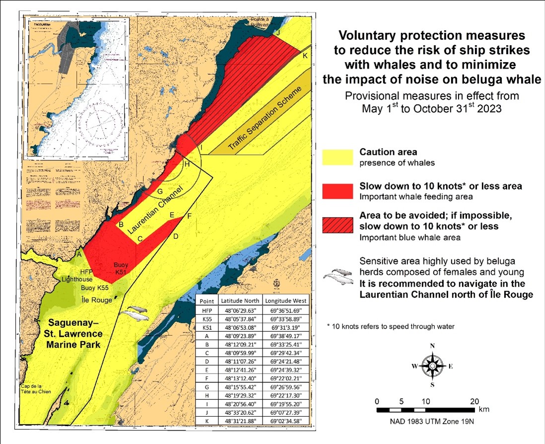
*407/23Saguenay–St. Lawrence Marine Park and Surrounding Waters – Whale Protection
(Recurrent publication of notice *407/23, originally published in the Notices to Mariners – Monthly Eastern Edition 04/2023 publication.)
The waters in and around the Saguenay–St. Lawrence Marine Park are well known for the resident endangered beluga population and the wide diversity of whales that migrate there to feed, particularly between April and November.
Regulatory protection measures
All whale species that are found in the St. Lawrence are
protected under the Marine Mammal Regulations,
pursuant to the Fisheries Act. Within the boundaries
of the Marine Park, specific measures are set out in the
Marine Activities in the Saguenay–St. Lawrence Marine Park
Regulations, pursuant to the establishment of the
Saguenay–St. Lawrence Marine Park Act. Any collision
with a marine mammal within the Marine Park must immediately be
reported to a park warden at 1-866-508-9888. For collisions
that occur outside the Marine Park or for any situation
involving a marine mammal that is dead or in trouble, contact
the emergency network at 1-877-722-5346 or on VHF channel
16.
For more information on the Saguenay–St. Lawrence Marine
Park, see notice 5C of the Notices to Mariners Annual
Edition 2023.
Voluntary protection measures
Provisional measures in effect from May 1 to October 31, 2023.
See map at the end of this notice.
These measures apply to merchant vessels and cruise ships
between Pointe à Boisvert and Cap de la Tête au Chien to
prevent collisions with whales. These measures should only be
taken when they will not jeopardize navigational
safety.
Caution area (yellow area): To reduce the
risk of collisions with whales that can be present anywhere
in this area, heightened vigilance of navigators is critical.
Posting a lookout is recommended in order to increase the
chances of seeing the whales and thus taking necessary
measures to avoid them. If bypassing the whales is not
possible, slow down and wait for the animals to move away to
a distance greater than 400 metres (0.215 nautical miles)
before resuming original speed. It is more difficult to see
the animals at night therefore increased caution is
recommended.
Slow down to 10 knots or less area (red
area): To reduce the risk of collisions with whales
in this feeding area, it is recommended that vessels slow
down to a maximum speed through the water of 10 knots and
post a lookout. It is further recommended to remain in the
Laurentian Channel to the north of Île Rouge to minimize the
impact of noise in a sensitive area south of this island,
which is highly frequented by herds of beluga whales composed
of females and young.
Area to be avoided (hatched red area): To
reduce noise and the risk of collisions with whales, vessels
should avoid transiting through this area which is highly
frequented by blue whales, an endangered species. If the area
cannot be avoided, slow down to a speed through the water of
10 knots or less.
*408/23Saguenay–St. Lawrence Marine Park - Beluga Whale Protection: Slowdown Area at the Mouth of the Saguenay Fjord and Area Closure at Baie Sainte-Marguerite
(Recurrent publication of notice *408/23, originally published in the Notices to Mariners – Monthly Eastern Edition 04/2023 publication.)
The Saguenay–St. Lawrence Marine Park and its surrounding area are at the heart of endangered beluga whale critical summer habitat. Marine mammal protection measures have been put in place in accordance with the Marine Activities in the Saguenay–St. Lawrence Marine Park Regulations within the limits of the Marine Park.
However, important feeding, calving and rearing areas for beluga whales require greater protection to ensure the recovery of the species. The portion of the Saguenay situated between the mouth of the Fjord and Baie Sainte-Marguerite is one of the areas most used by females and their young from May to October. The mouth of the Saguenay is known as a feeding ground and Baie Sainte-Marguerite as a calving and rearing area.
In order to prevent collisions with beluga whales, a compulsory 15-knot slowdown area is in effect from May 1st to October 31st at the mouth of the Saguenay. To ensure tranquility for female belugas and their young during the critical calving period, access to Baie Sainte-Marguerite is prohibited to all vessels from June 21st to September 21st, except for special authorizations (see description below).
For safety reasons, the slowdown area measure at the mouth of the Saguenay Fjord does not apply to cargo ships (see the monthly edition of Notice to Mariners from May to October for voluntary protection measures in the St. Lawrence Estuary). An enhanced vigilance is, however, recommended to all navigators between the mouth of the Saguenay Fjord and Baie Sainte-Marguerite for the protection of beluga whales.
For more information on the Saguenay–St. Lawrence Marine Park, see notice 5C of the Notices to Mariners Annual Edition 2023 or visit marinepark.qc.ca.
REGULATORY PROTECTION MEASURES — BELUGA WHALE
Entire Marine Park Territory:
•When beluga whales are less than half a nautical mile
(926 metres) from a motorized vessel, the vessel must
maintain a steady speed of between 5 and 10 knots.
•All vessels, including human-powered vessels (kayaks
and canoes), must continue to move forward and maintain their
heading.
•All vessels must maintain a minimum distance of 400
metres from beluga whales at all times.
For more information concerning the regulations, consult: marinepark.ca/protect/.
Mouth of the Saguenay Fjord (Figure 1) — Slowdown Area (area crosshatched in red):
•Maximum speed at the mouth of the Saguenay between buoys S7 and S8 and the ferry docks between Baie-Sainte-Catherine and Tadoussac is 15 knots from May 1st to October 31st.
Baie Sainte-Marguerite (Figure 2) — Area Closure (red area):
•From June 21st to September 21st, vessels must not enter the red area, which follows a line between Cap Nord-Ouest and Cap Sainte-Marguerite.
•Special authorizations are granted only for kayaks, canoes and recreational fishermen who must travel without stopping along a corridor within 10 metres of the shore or in shallow areas.
VOLUNTARY PROTECTION MEASURES
Baie Sainte-Marguerite sector (Figure 2) — Transit Area (area crosshatched in yellow):
•From June 21st to September 21st, navigation in this area is recommended at a speed of between 5 and 10 knots without stopping.
The purpose of this transit area is to favour respect of the Marine Activities in the Saguenay–St. Lawrence Marine Park Regulations, since beluga whales are often present in the Baie Sainte-Marguerite sector.
Information
All incidents, including collisions with whales, must be reported without delay by calling 1-866-508-9888. For any other situation concerning a marine mammal that is either dead or in trouble, contact the Marine Mammal Emergency Response Network at 1-877-722-5346, or use VHF channel 16.
Figure 1

Figure 2

*505/23Canadian Hydrographic Service – Magnetic Declination Calculations
(Recurrent publication of notice *505/23, originally published in the Notices to Mariners – Monthly Eastern Edition 05/2023 publication.)
Mariners are advised that CHS has adopted the harmonized World Magnetic Model (WMM), as found on the NCEI/NOAA website. Old compass rose declination information on CHS navigational products can be updated using this website: https://www.ngdc.noaa.gov/geomag/calculators/magcalc.shtml#declination. While the differences in the model declinations are small each year, they can become more significant over a large period of time.
*507/23Protecting the North Atlantic Right Whale: Speed Restriction Measures in the Gulf of St. Lawrence
(Recurrent publication of notice *507/23, originally published in the Notices to Mariners – Monthly Eastern Edition 05/2023 publication.)
Reference: Notice *401/23 is cancelled.
PURPOSE
This notice describes the speed restriction zones that vessels must follow in the Gulf of St. Lawrence.
The Government of Canada has established these zones to reduce the risk of vessel colliding with North Atlantic right whales (NARW).
BACKGROUND
Due to changing migration patterns of North Atlantic right whales and their increased presence in the Gulf of St. Lawrence, the Government of Canada has set seasonal speed restrictions in specific zones. These speed restrictions zones are defined as “static zones”, “dynamic shipping zones”, “seasonal management areas”, a “voluntary seasonal slowdown zone’’ and a “restricted area”. See the map below for details.
Note: Vessels must follow Navigational Warnings outlining the speed restrictions. The Interim Order for the Protection of North Atlantic Right Whales (Eubalaena Glacialis) in the Gulf of St. Lawrence, 2023 enables the issuance of Navigational Warnings (NAVWARNs) imposing speed restrictions and navigation restrictions.
Speed restriction zones are described in monthly Notices to Mariners (NOTMARs), which are published by the Canadian Coast Guard. The status of these zones is broadcasted through NAVWARNs, which are published by the Coast Guard’s Marine Communications and Traffic Services Centres.
CHANGES TO SPEED RESTRICTION ZONES AND MEASURES
Based on consultations with industry and on scientific data, changes to the speed restriction zones will be effective from April 19th, 2023, while the restricted area will be implemented based on whale presence:
•A voluntary seasonal slowdown of 10.0 knots over the ground spanning from Cabot Strait (a line running from Cape North NS to Cape Ray NL) to the eastern edge of dynamic shipping zone E will be implemented at the beginning and end of the North Atlantic right whale season.
Please check the latest NAVWARN for all speed restrictions currently in effect.
SPEED RESTRICTION MEASURES FOR 2023
These restrictions will be in effect from April 19 to November 15, 2023.
Exceptions
The following exception will apply to all measures:
a)a vessel in distress or providing assistance to a person or a vessel in distress;
b)a government vessel being used
(i) for law enforcement activities;
(ii) for search and rescue operations; or
(iii) to ensure the competency of the crew or the operational readiness of the vessel or crew with respect to such activities or operations.
STATIC ZONES
In the static zones, all vessels above 13 m in length overall (LOA) must proceed at a speed of not more than 10.0 knots over the ground.
Exceptions
Air cushion vessels operated by or on behalf of the Government
of Canada that are engaged in ice-clearing activities from
April to June in and around Chaleur Bay are exempted when in
operation.
36.57 m (20-fathom) shallow water protocol
Vessels engaged in any commercial fishing activity may proceed at a safe operational speed in waters not more than 36.57 m (20 fathom) deep.
If a notice to fish harvesters and a NAVWARN state that at least one right whale has been detected within the static zone in waters that are not more than 36.57 m deep, the 10 knots speed limit will apply to all vessels above 13 m in length overall (LOA) for 15 days after the day on which the whale was detected.
If a new notice to fish harvesters and a new NAVWARN are published or broadcast during the last seven days of the 15-day period, the speed limit will continue to apply for a further 15 days after the day on which the new detection took place.
|
Coordinates for the northern static zone:
•50° 20’ N, 065° 00’ W |
Coordinates for the southern static zone:
•48° 40’ N, 065° 00’ W |
DYNAMIC SHIPPING ZONES
There are five dynamic shipping zones (DSZ) located in the routeing systems north and south of Anticosti Island: A, B, C, D and E.
Coordinates for the dynamic shipping zones:
|
Zone A
•49⁰ 41’ N, 065⁰ 00’ W |
Zone B
•49⁰ 22’ N, 064⁰ 00’ W |
Zone C
•49⁰ 00’ N, 063⁰ 00’ W |
|
Zone D
•50⁰ 16’ N, 064⁰ 00’ W |
Zone E
•48⁰ 35’ N, 062⁰ 00’ W |
|
When a North Atlantic right whale is detected in a dynamic shipping zone:
•All vessels will be notified via a NAVWARN; and
•Vessels above 13 m in length overall
(LOA) must proceed at a speed of not more than 10.0 knots over
the ground within that zone.
Even though dynamic shipping zones overlap with static zones, vessels can travel at a safe operational speed in dynamic shipping zones when they are not under speed restriction. Mariners must also keep in mind that North Atlantic right whales may be nearby.
Speed restrictions in the dynamic shipping zones
The detection of North Atlantic right whales in one or more dynamic shipping zone(s), will trigger a speed restriction in the concerned zone(s). The speed restriction in the dynamic shipping zone(s) will be in effect for 15 days from the date of detection. In the event of a new North Atlantic right whale detection occurring in the last 7 days of the 15-day slowdown period, the speed restriction will be extended for an additional 15 days from the date of the new detection. This would continue until no NARW are detected.
When a NAVWARN is issued implementing a speed restriction in one or more dynamic shipping zone(s), vessels above 13 m in length (LOA) must not exceed a speed of 10.0 knots over the ground. Within any dynamic zone that is not subject to a speed restriction, mariners may proceed at a safe operational speed. Mariners are encouraged to take into consideration the potential for their vessel striking North Atlantic right whales when considering a “safe operational speed” during navigation.
SEASONAL MANAGEMENT AREAS
Seasonal management area 1 (SMA-1) and seasonal management area 2 (SMA-2) are speed restriction areas located north and south of dynamic shipping zone E, respectively.
Within seasonal management areas, vessels above 13 m in length (LOA):
•must restrict their speed so as not to exceed 10.0 knots over the ground from April 19th to June 27th, 2023; and
•are allowed to proceed at a safe operational speed from June 28th to November 15th, 2023, unless a North Atlantic right whale is detected. If a whale is detected, a speed restriction of 10.0 knots over the ground will be triggered for 15 days from the date of detection. In the event of a new North Atlantic right whale detection occurring in the last 7 days of the 15-day slowdown period, the speed restriction will be extended for an additional 15 days from the date of the new detection. This would continue until no North Atlantic right whales are detected.
|
Coordinates for the SMA-1:
•49° 04’ N, 062° 00’ W |
Coordinates for the SMA-2:
•48° 24’ N, 062° 00’ W |
RESTRICTED AREA
In the summer months, an important proportion of the total North Atlantic right whale population gathers for feeding and surface activity near the Shediac Valley. Since this makes the North Atlantic right whale more susceptible to vessel collisions, a mandatory restricted area will be implemented in and near the Shediac Valley and will come into force once 80% of the restricted area is closed to fishing for the season as per the Department of Fisheries and Oceans’s right whale closure protocol. The restricted area will be lifted once the North Atlantic right whale detections decrease in the restricted area.
The size and location of the area are determined based on
historical detection data of North Atlantic right whales. All
necessary details can be found in the Interim Order for the
Protection of North Atlantic Right Whales (Eubalaena Glacialis)
in the Gulf of St. Lawrence, 2023. Triggering and lifting of
the restricted area will be communicated to mariners through a
NAVWARN and notice to fish harvesters.
Vessels above 13 m in length (LOA) will be
required to:
•avoid the area unless they are part of the exceptions listed in the Interim Order for the Protection of North Atlantic Right Whales (Eubalaena Glacialis) in the Gulf of St. Lawrence, 2023;
•transit the area at a speed not exceeding 8.0 knots over the ground if they are part of the exceptions.
The following exceptions will apply to the restricted area. The following listed vessels can travel through the area at not more than 8.0 knots over the ground:
•A vessel being used for commercial fishing;
•A vessel being used for fishing under the authority of
a licence issued under the Aboriginal Communal Fishing
Licences Regulations;
•A vessel being used for research purposes on behalf of
the Government of Canada;
•A vessel being used as part of the Department of
Fisheries and Oceans’ Marine Mammal Response Program to assist
a marine mammal or sea turtle in distress or to access or
retrieve a deceased marine mammal or sea turtle;
•A vessel authorized by the Government of Canada to
retrieve or identify the location of abandoned or lost fishing
gear;
•A vessel involved in pollution response
operations;
•A vessel avoiding immediate or unforeseen danger;
•A vessel involved in research relating to right whales as part of a project that has received funding from the Government of Canada.
The following vessels can travel through the restricted area at a speed over 8.0 knots, but below 10.0 knots over the ground as required by the static speed restriction zone:
•A vessel being used by an employee of the Government of Canada or peace officer who is performing their duties.
Coordinates for the restricted area:
•48˚31.8’ N, 063˚39.6’ W
•48˚24.72’ N, 063˚17.88’ W
•47˚18.84’ N, 064˚10.8’ W
•47˚27.18’ N, 064˚30.72’ W
Inclement weather exception
Mariners will be notified in advance via a NAVWARN should the speed restriction status change in any zone or area, due to inclement weather.
Within any zone or area that is no longer subject to a speed restriction due to adverse weather conditions, mariners may proceed at a safe operational speed. Mariners are however encouraged to take into consideration the potential for their vessel striking North Atlantic right whales when considering a “safe operational speed” during navigation.
*Non-excepted vessels are still prohibited from transiting through the restricted area.
VOLUNTARY SEASONAL SLOWDOWN IN CABOT STRAIT
To coincide with the North Atlantic right whales entering and exiting the Gulf of St. Lawrence in large numbers, a voluntary seasonal slowdown is being put in place in Cabot Strait from April 19th to June 27th, 2023, and from September 27th to November 15th, 2023.
•During these periods, vessels above 13 m in length (LOA) are requested to voluntarily reduce their speed as to not exceed 10.0 knots over the ground.
Voluntary seasonal slowdown zone coordinates:
•48° 10.5’ N, 061° 00’ W
•47° 37.2’ N, 059° 18.5’ W
•47° 02’ N, 060° 23.7’ W
•47° 58.1’ N, 061° 03.5’ W
•48° 00’ N, 061° 00’ W
MAP OF THE GULF OF ST. LAWRENCE
The following map shows
•the static zones (north and south), in pink;
•the dynamic shipping zones (A, B, C, D and E), in
green;
•the seasonal management areas, in dark pink;
•the voluntary seasonal slowdown zone, in grey;
•the restricted area, in dark blue; and
•the 36.57 m (20 fathom) shallow water protocol line.

This map is for visual representation only and is not to be used
for navigation or enforcement.
Roseway Basin – Area to be Avoided
The Roseway Basin, located approximately 20 nautical miles south of Cape Sable Island, Nova Scotia, is a critical habitat for North Atlantic right whales, which have been observed to gather in the area on a seasonal basis in Canadian waters. This critical habitat is also located near key shipping routes. In 2007, Canada, with the support of many groups with varied interests, proposed to the International Maritime Organization (IMO) the establishment of a seasonal Area to be Avoided in the Roseway Basin to protect North Atlantic right whales, which IMO accepted and adopted.
To reduce the risk of vessels colliding with North Atlantic right whales, it is recommended that vessels of 300 gross tonnages and more, in transit during the period of June 1 through December 31, avoid the Roseway Basin area. Smaller vessels are also encouraged to avoid passage through this area. If passage is necessary within the Area to be Avoided, it is recommended that all mariners decrease their vessel speed to no more than 10 knots, when safe to do so.
Roseway Basin coordinates:
•43° 16’ N 064° 55’ W
•42° 47’ N 064° 59’ W
•42° 39’ N 065° 31’ W
•42° 52’ N 066° 05’ W
NAVWARN BROADCASTS
The Canadian Coast Guard issues NAVWARNs:
•by radio broadcast; and
•online at Canada’s Maritime Information Portal and its Navigational Warnings site.
Mariners must ensure they have accurate and up-to-date
information about the protection of the North Atlantic right
whale, as in all applicable NOTMARs and NAVWARNs.
For the North Atlantic right whale speed restrictions, the
NAVWARN(s) currently in effect will be provided to vessels
subject to the Vessel Traffic Services Zone
Regulations or the Eastern Canada Vessel Traffic
Services Zone Regulations:
Outbound vessels will receive NAVWARNs
•at Calling-in-Point 10 (St-Laurent); or
•upon a departure downstream from the Quebec pilot station (including the Saguenay River, Chaleur Bay, Miramichi Bay, etc.)
Inbound vessels will receive NAVWARNs
•when a clearance to enter Canadian waters is granted
Vessels in transit will receive NAVWARNs
•at the last reporting point prior to entering the mandatory speed restriction zones; and/or
•at 10 nautical miles before they enter the mandatory speed restriction zones
For those vessels not subject to the above-mentioned regulations, vessel operators are required to monitor broadcasts by the Canadian Coast Guard’s Marine Communications and Traffic Services network for the most up-to-date information. For marine radio frequencies and broadcast times, information may be found in the Radio Aids to Marine Navigation publication.
AIDS TO NAVIGATION
The Canadian Coast Guard is currently testing virtual Automatic Identification System (AIS) aids to navigation (AIS AtoN) in specific areas. These aids notify mariners of a dynamic shipping zone and/or a seasonal management area subject to a speed restriction.
Each zone is delimited by four to six virtual AIS AtoN, which can be displayed on a ship’s navigation equipment, such as
•Electronic Chart Display and Information System
(ECDIS);
•Electronic Chart System (ECS);
•RADAR;
•Minimum Keyboard Display (MKD); and
•Electronic Nautical Chart (ENC).
The Canadian Coast Guard broadcasts the virtual AIS AtoN only when a speed restriction is in effect in one or more testing zones.
Mariners must select the virtual AIS AtoN symbol to view a message such as “SectA1 Spd Lim 10 kt.” This message refers to a speed restriction in effect for a specific zone.
Note: This system is not the primary method of communicating this information.
COMPLIANCE AND ENFORCEMENT
Vessels must comply with the Interim Orders made pursuant to the Canada Shipping Act, 2001, and any NAVWARNs broadcasted and published by the Canadian Coast Guard relating to the Interim Orders, aimed at regulating the navigation for the purposes of protecting the North Atlantic right whales.
If a vessel does not comply with the Interim Orders or instructions in the NAVWARNs related to the Interim Orders, the vessel could face:
•administrative monetary penalties up to a maximum of CAN $250,000; and/or
•penal sanctions under the Canada Shipping Act, 2001 is liable on summary conviction to a fine of not more than CAN $1,000,000 or to imprisonment for a term of not more than 18 months, or to both.
If a vessel appears to have violated the speed restriction, Transport Canada Marine Safety inspectors will review all information provided through AIS and seek an explanation from the master.
No exemptions to the speed restriction will be granted in advance. However, if a deviation from the speed restrictions is necessary for safety reasons, the following information must be entered into the bridge logbook:
•reason(s) for deviation;
•speed at which vessel is operated;
•latitude and longitude at time of deviation;
•time and duration of deviation; and
•master of the vessel shall sign and date the bridge
logbook entry.
For any deviation, Transport Canada will review and consider reasons such as:
•navigating to ensure vessel safety;
•weather conditions;
•force majeure (unforeseeable circumstances); and
•responding to emergencies.
REPORT A NORTH ATLANTIC RIGHT WHALE SIGHTING
If you see live, free-swimming whales:
•Email: DFO.GLFWhales-BaleinesGLF.MPO@dfo-mpo.gc.ca
•When reporting near sightings of North Atlantic right whales, you must include: GPS location (latitude and longitude), date and time of sighting, number of animals, photograph(s)/video(s) collected and if possible behavior of animals observed (ex., feeding, travelling, diving).
If you see a North Atlantic right whale (and all other marine mammals) entangled, injured or dead, please document and report it immediately to the regional Response Network.
•When documenting you should collect: GPS location (latitude and longitude), date and time of sighting, number of animals, photograph(s)/video(s), and description of the incident to provide to the Response Network.
Southern part of the Gulf of St. Lawrence (New Brunswick, Nova Scotia & Prince Edward Island)
Marine Animal Response Society
Telephone: 1-866-567-6277
Newfoundland and Labrador
Whale Release and Strandings Newfoundland and Labrador (Tangly
Whales Inc.)
Telephone: 1-888-895-3003 or 1-709-895-3003
Quebec
Baleines en direct (GREMM)
Telephone: 1-877-722-5346
Report a marine mammal or sea turtle incident or sighting:
For more information on reporting other marine mammal or sea turtle sighting and incidents: https://www.dfo-mpo.gc.ca/species-especes/mammals-mammiferes/report-rapport/page01-eng.html
Please consult Whale Insight for the latest right
whale observations:
https://gisp.dfo-mpo.gc.ca/apps/WhaleInsight/eng/?locale=en
*901/23Canadian Hydrographic Service – Electronic Navigational Charts
|
S-57 ENC Number |
Chart Title |
ENC Compilation Scale |
Published |
|
New Charts |
|||
|
CA43XLWA (Edn 1.000) |
Transit4500N07500W |
1:11 000 |
2023-09-15 |
|
CA43XM7A (Edn 1.000) |
Transit4500N07400W |
1:11 000 |
2023-09-15 |
|
CA448M7A (Edn 1.000) |
Transit4600N07400W |
1:11 000 |
2023-09-15 |
|
CA448MHA (Edn 1.000) |
Transit4600N07300W |
1:11 000 |
2023-09-15 |
|
CA448MTA (Edn 1.000) |
Transit4600N07200W |
1:11 000 |
2023-09-15 |
|
CA448N4A (Edn 1.000) |
Transit4600N07100W |
1:22 500 |
2023-09-15 |
|
CA44JN4A (Edn 1.000) |
Transit4700N07100W |
1:22 500 |
2023-09-15 |
|
CA44JNEA (Edn 1.000) |
Transit4700N07000W |
1:22 500 |
2023-09-15 |
|
CA44JQJA (Edn 1.000) |
Transit4700N06300W |
1:45 000 |
2023-09-06 |
|
CA44JQUA (Edn 1.000) |
Transit4700N06200W |
1:45 000 |
2023-09-06 |
|
CA44UN4A (Edn 1.000) |
Transit4800N07100W |
1:11 000 |
2023-09-15 |
|
CA44UNEA (Edn 1.000) |
Transit4800N07000W |
1:22 500 |
2023-09-15 |
|
CA44UNQA (Edn 1.000) |
Transit4800N06900W |
1:22 500 |
2023-09-15 |
|
CA455P1A (Edn 1.000) |
Transit4900N06800W |
1:22 500 |
2023-09-13 |
|
CA455PBA (Edn 1.000) |
Transit4900N06700W |
1:22 500 |
2023-09-13 |
|
CA455PMA (Edn 1.000) |
Transit4900N06600W |
1:22 500 |
2023-09-13 |
|
CA45FPBA (Edn 1.000) |
Transit5000N06700W |
1:22 500 |
2023-09-13 |
|
CA45FPMA (Edn 1.000) |
Transit5000N06600W |
1:22 500 |
2023-09-13 |
|
CA45FPXA (Edn 1.000) |
Transit5000N06500W |
1:22 500 |
2023-09-06 |
|
CA45FQ8A (Edn 1.000) |
Transit5000N06400W |
1:22 500 |
2023-09-06 |
|
CA45FQJA (Edn 1.000) |
Transit5000N06300W |
1:22 500 |
2023-09-06 |
|
CA45FQUA (Edn 1.000) |
Transit5000N06200W |
1:22 500 |
2023-09-06 |
|
CA45FR5A (Edn 1.000) |
Transit5000N06100W |
1:22 500 |
2023-09-06 |
|
CA45FRFA (Edn 1.000) |
Transit5000N06000W |
1:22 500 |
2023-09-06 |
|
CA45FRRA (Edn 1.000) |
Transit5000N05900W |
1:22 500 |
2023-09-06 |
|
CA45RRFA (Edn 1.000) |
Transit5100N06000W |
1:11 000 |
2023-09-06 |
|
CA45RRRA (Edn 1.000) |
Transit5100N05900W |
1:11 000 |
2023-09-06 |
|
CA45RS2A (Edn 1.000) |
Transit5100N05800W |
1:11 000 |
2023-09-06 |
|
CA541M6B (Edn 1.000) |
Port4530N07410W |
1:4 000 |
2023-09-08 |
|
CA541M7B (Edn 1.000) |
Port4530N07400W |
1:4 000 |
2023-09-08 |
|
CA541M9A (Edn 1.000) |
Port4530N07380W |
1:6 000 |
2023-09-06 |
|
CA542M5A (Edn 1.000) |
Port4540N07420W |
1:2 000 |
2023-09-06 |
|
CA542M6A (Edn 1.000) |
Port4540N07410W |
1:2 000 |
2023-09-06 |
|
CA542M7A (Edn 1.000) |
Port4540N07400W |
1:6 000 |
2023-09-06 |
|
CA542M8A (Edn 1.000) |
Port4540N07390W |
1:6 000 |
2023-09-06 |
|
CA542M9A (Edn 1.000) |
Port4540N07380W |
1:6 000 |
2023-09-06 |
|
CA542MAA (Edn 1.000) |
Port4540N07370W |
1:6 000 |
2023-09-06 |
|
CA542MBA (Edn 1.000) |
Port4540N07360W |
1:6 000 |
2023-09-06 |
|
CA542MCA (Edn 1.000) |
Port4540N07350W |
1:6 000 |
2023-09-06 |
|
CA543M4A (Edn 1.000) |
Port4550N07430W |
1:2 000 |
2023-09-06 |
|
CA543M7A (Edn 1.000) |
Port4550N07400W |
1:6 000 |
2023-09-06 |
|
CA543M8A (Edn 1.000) |
Port4550N07390W |
1:6 000 |
2023-09-06 |
|
CA543M9A (Edn 1.000) |
Port4550N07380W |
1:6 000 |
2023-09-06 |
|
CA543MAA (Edn 1.000) |
Port4550N07370W |
1:6 000 |
2023-09-06 |
|
CA543MBA (Edn 1.000) |
Port4550N07360W |
1:6 000 |
2023-09-06 |
|
CA543MCA (Edn 1.000) |
Port4550N07350W |
1:6 000 |
2023-09-06 |
|
CA544MAA (Edn 1.000) |
Port4560N07370W |
1:6 000 |
2023-09-06 |
|
CA544MBA (Edn 1.000) |
Port4560N07360W |
1:6 000 |
2023-09-06 |
|
CA544MCA (Edn 1.000) |
Port4560N07350W |
1:6 000 |
2023-09-06 |
|
CA545MBA (Edn 1.000) |
Port4570N07360W |
1:6 000 |
2023-09-06 |
|
CA545MCA (Edn 1.000) |
Port4570N07350W |
1:6 000 |
2023-09-06 |
|
CA545MDA (Edn 1.000) |
Port4570N07340W |
1:2 000 |
2023-09-06 |
|
CA546MDA (Edn 1.000) |
Port4580N07340W |
1:4 000 |
2023-09-06 |
|
CA546MEA (Edn 1.000) |
Port4580N07330W |
1:4 000 |
2023-09-06 |
|
CA54AMLA (Edn 1.000) |
Port4620N07270W |
1:2 000 |
2023-09-06 |
|
CA54BMMA (Edn 1.000) |
Port4630N07260W |
1:6 000 |
2023-09-13 |
|
CA54BMNA (Edn 1.000) |
Port4630N07250W |
1:6 000 |
2023-09-13 |
|
CA54BMPA (Edn 1.000) |
Port4630N07240W |
1:6 000 |
2023-09-06 |
|
CA54CMPA (Edn 1.000) |
Port4640N07240W |
1:6 000 |
2023-09-06 |
|
CA54EMUA (Edn 1.000) |
Port4660N07190W |
1:2 000 |
2023-09-06 |
|
CA54FN0A (Edn 1.000) |
Port4670N07140W |
1:6 000 |
2023-09-06 |
|
CA54FN1A (Edn 1.000) |
Port4670N07130W |
1:6 000 |
2023-09-06 |
|
CA54FN2A (Edn 1.000) |
Port4670N07120W |
1:6 000 |
2023-09-06 |
|
CA54GN1A (Edn 1.000) |
Port4680N07130W |
1:6 000 |
2023-09-06 |
|
CA54GN2A (Edn 1.000) |
Port4680N07120W |
1:6 000 |
2023-09-06 |
|
CA54LNBA (Edn 1.000) |
Port4720N07030W |
1:2 000 |
2023-09-06 |
|
CA54LQUA (Edn 1.000) |
Port4720N06200W |
1:2 000 |
2023-09-22 |
|
CA54LQVA (Edn 1.000) |
Port4720N06190W |
1:4 000 |
2023-09-06 |
|
CA54NNAA (Edn 1.000) |
Port4740N07040W |
1:2 000 |
2023-09-06 |
|
CA54PQWA (Edn 1.000) |
Port4750N06180W |
1:2 000 |
2023-09-06 |
|
CA54PQYA (Edn 1.000) |
Port4750N06160W |
1:6 000 |
2023-09-06 |
|
CA54QQYA (Edn 1.000) |
Port4760N06160W |
1:6 000 |
2023-09-06 |
|
CA54SNFA (Edn 1.000) |
Port4780N06990W |
1:2 000 |
2023-09-06 |
|
CA54SNJA (Edn 1.000) |
Port4780N06960W |
1:2 000 |
2023-09-06 |
|
CA54UPKA (Edn 1.000) |
Port4800N06620W |
1:2 000 |
2023-09-06 |
|
CA54UPSA (Edn 1.000) |
Port4800N06550W |
1:2 000 |
2023-09-06 |
|
CA54UPUA (Edn 1.000) |
Port4800N06530W |
1:2 000 |
2023-09-06 |
|
CA54UPVA (Edn 1.000) |
Port4800N06520W |
1:2 000 |
2023-09-06 |
|
CA54VPKA (Edn 1.000) |
Port4810N06620W |
1:2 000 |
2023-09-06 |
|
CA54VPNA (Edn 1.000) |
Port4810N06590W |
1:2 000 |
2023-09-06 |
|
CA54WQ0A (Edn 1.000) |
Port4820N06480W |
1:4 000 |
2023-09-06 |
|
CA54XQ1A (Edn 1.000) |
Port4830N06470W |
1:6 000 |
2023-09-06 |
|
CA54YMSA (Edn 1.000) |
Port4840N07210W |
1:2 000 |
2023-08-29 |
|
CA54YMTA (Edn 1.000) |
Port4840N07200W |
1:4 000 |
2023-08-29 |
|
CA54YQ4A (Edn 1.000) |
Port4840N06440W |
1:2 000 |
2023-09-06 |
|
CA550MQA (Edn 1.000) |
Port4850N07230W |
1:2 000 |
2023-08-29 |
|
CA551MNA (Edn 1.000) |
Port4860N07250W |
1:2 000 |
2023-08-29 |
|
CA551MUA (Edn 1.000) |
Port4860N07190W |
1:4 000 |
2023-08-29 |
|
CA552MSA (Edn 1.000) |
Port4870N07210W |
1:2 000 |
2023-08-29 |
|
CA552NPA (Edn 1.000) |
Port4870N06910W |
1:6 000 |
2023-09-06 |
|
CA553P5A (Edn 1.000) |
Port4880N06760W |
1:6 000 |
2023-09-08 |
|
CA555PBA (Edn 1.000) |
Port4900N06700W |
1:4 000 |
2023-09-08 |
|
CA556NYA (Edn 1.000) |
Port4910N06820W |
1:6 000 |
2023-09-22 |
|
CA556P0A (Edn 1.000) |
Port4910N06810W |
1:6 000 |
2023-09-22 |
|
CA556PHA (Edn 1.000) |
Port4910N06640W |
1:2 000 |
2023-09-06 |
|
CA556SUA (Edn 1.000) |
Port4910N05540W |
1:6 000 |
2023-09-22 |
|
CA557NYA (Edn 1.000) |
Port4920N06820W |
1:6 000 |
2023-09-22 |
|
CA557P0A (Edn 1.000) |
Port4920N06810W |
1:6 000 |
2023-09-22 |
|
CA557PVA (Edn 1.000) |
Port4920N06520W |
1:2 000 |
2023-09-08 |
|
CA558P5A (Edn 1.000) |
Port4930N06760W |
1:2 000 |
2023-09-08 |
|
CA559P8A (Edn 1.000) |
Port4940N06730W |
1:2 000 |
2023-09-06 |
|
CA55EPCA (Edn 1.000) |
Port4990N06690W |
1:6 000 |
2023-09-08 |
|
CA55EPDA (Edn 1.000) |
Port4990N06680W |
1:6 000 |
2023-09-08 |
|
CA55FPCA (Edn 1.000) |
Port5000N06690W |
1:6 000 |
2023-09-08 |
|
CA55FPDA (Edn 1.000) |
Port5000N06680W |
1:6 000 |
2023-09-08 |
|
CA55PRRA (Edn 1.000) |
Port5080N05900W |
1:6 000 |
2023-09-08 |
|
CA55US9A (Edn 1.000) |
Port5130N05730W |
1:6 000 |
2023-09-06 |
|
CA55USAA (Edn 1.000) |
Port5130N05720W |
1:6 000 |
2023-09-06 |
|
CA55VS3A (Edn 1.000) |
Port5140N05790W |
1:4 000 |
2023-09-08 |
|
CA55VS9A (Edn 1.000) |
Port5140N05730W |
1:6 000 |
2023-09-06 |
|
CA55VSAA (Edn 1.000) |
Port5140N05720W |
1:6 000 |
2023-09-06 |
|
New Editions |
|||
|
CA276821 (Edn 2.000) |
Murphy Head to Button Islands |
1:100 000 |
2023-09-29 |
|
CA376076 (Edn 2.000) |
Cape Tormentine à/to West Point |
1:50 000 |
2023-09-01 |
|
CA376243 (Edn 3.000) |
Trinity Bay - Northern Portion/Partie Nord |
1:30 000 |
2023-09-29 |
|
Charts Permanently Withdrawn |
|||
|
CA379026 |
Archipel de Mingan |
Cancelled by CA45FQ8A,CA45FPXA |
|
|
CA379028 |
Pointe de Moisie à/to Île du Grand Caoui |
Cancelled by CA45FPMA,CA45FPBA,CA455PMA,CA455PBA,CA455P1A |
|
|
CA379029 |
Cap de la Tête au Chien à/to Cap aux Oies |
Cancelled by CA44JNEA,CA44JN4A |
|
|
CA379093 |
Pointe Curlew à/to Baie Washtawouka |
Cancelled by CA45FQUA |
|
|
CA379115 |
Île du Petit Mecatina aux/to Îles Sainte-Marie |
Cancelled by CA45FRFA,CA45FR5A |
|
|
CA379131 |
Baie Piashti à/to Île au Marteau |
Cancelled by CA45FQJA,CA45FQ8A |
|
|
CA379139 |
Île à la Brume à/to Pointe Curlew |
Cancelled by CA45FR5A,CA45FQUA |
|
|
CA379140 |
Baie Washtawouka à/to Baie Piashti |
Cancelled by CA45FQUA,CA45FQJA |
|
|
CA379164 |
ÎIes Sainte-Marie à/to Île à la Brume |
Cancelled by CA45FRFA,CA45FR5A |
|
|
CA379216 |
Iles de la Madeleine |
Cancelled by CA44JQUA,CA44JQJA |
|
|
CA379232 |
Île du Bic au/to Cap de la Tête au Chien |
Cancelled by CA44UNQA,CA44UNEA,CA44JNEA |
|
|
CA476127 |
Buctouche Harbour |
Cancelled by CA376076 |
|
|
CA476128 |
Cocagne et/and Shediac |
Cancelled by CA376076 |
|
|
CA476181 |
Summerside Harbour and Approaches/et les approches |
Cancelled by CA376076 |
|
|
CA479014 |
Batiscan au/to Lac Saint-Pierre |
Cancelled by CA448MHA |
|
|
CA479017 |
Donnacona à/to Batiscan |
Cancelled by CA448MTA,CA448MHA |
|
|
CA479020 |
Québec à/to Donnacona |
Cancelled by CA448MTA |
|
|
CA479021 |
Cap aux Oies à/to Sault-au-Cochon |
Cancelled by CA44JNEA,CA44JN4A |
|
|
CA479025 |
Sault-au-Cochon à/to Québec |
Cancelled by CA44JN4A,CA448N4A |
|
|
CA479051 |
Baie des Homards Mouillages/Anchorages |
Cancelled by CA455PBA,CA455P1A |
|
|
CA479052 |
Île aux Oeufs Mouillages/Anchorages |
Cancelled by CA455P1A |
|
|
CA479053 |
Tadoussac à/to Cap Éternité |
Cancelled by CA44UNEA,CA44UN4A |
|
|
CA479057 |
Mont-Louis |
Cancelled by CA455PMA |
|
|
CA479058 |
Sainte-Anne-des-Monts |
Cancelled by CA455PBA |
|
|
CA479078 |
Cap Éternité à/to Cap à l'Est |
Cancelled by CA44UN4A |
|
|
CA479082 |
Continuation A - Sault-au-Cochon à/to Québec |
Cancelled by CA44JN4A,CA448N4A,CA448MTA |
|
|
CA479087 |
Ile St-Louis à Cap Éternité - Continuation A |
Cancelled by CA44UNEA,CA44UN4A |
|
|
CA479094 |
Cap à l'Est à Saint-Fulgence - Continuation A |
Cancelled by CA44UN4A |
|
|
CA479099 |
Chenal du Bic et les approches/and approaches |
Cancelled by CA44UNQA |
|
|
CA479129 |
Lac Saint-Pierre |
Cancelled by CA448MHA,CA448M7A |
|
|
CA479137 |
Baie Coacoachou |
Cancelled by CA45FR5A |
|
|
CA479155 |
Sorel à/to Varennes |
Cancelled by CA448M7A,CA43XM7A |
|
|
CA479202 |
Lac Saint-Louis à/to Carillon |
Cancelled by CA43XM7A,CA43XLWA |
|
|
CA479210 |
Laval à/to Baie de Vaudreuil |
Cancelled by CA43XM7A,CA43XLWA |
|
|
CA479228 |
Lac Saint-Louis |
Cancelled by CA43XM7A,CA43XLWA |
|
|
CA479247 |
Blanc Sablon à/to Baie de Bonne-Espérance |
Cancelled by CA45RS2A |
|
|
CA479249 |
Baie de Bonne-Espérance à/to Île Mistanoque |
Cancelled by CA45RS2A,CA45RRRA |
|
|
CA479257 |
Continuation A |
Cancelled by CA45RRRA |
|
|
CA479259 |
Îles Mack à/to La Tabatière |
Cancelled by CA45RRRA,CA45RRFA,CA45FRRA,CA45FRFA |
|
|
CA479261 |
La Tabatière à/to Île du Gros Mécatina (Ouest/West) |
Cancelled by CA45FRRA,CA45FRFA |
|
|
CA479263 |
Île Mistanoque aux/to Îles Mack (Ouest/West) |
Cancelled by CA45RRRA |
|
|
CA479264 |
Île Mistanoque aux/to Îles Mack (Est/East) |
Cancelled by CA45RRRA |
|
|
CA479265 |
La Tabatière à/to Île du Gros Mécatina (Est/East) |
Cancelled by CA45FRRA,CA45FRFA |
|
|
CA576659 |
Botwood |
Cancelled by CA556SUA |
|
|
CA579001 |
Port de Montréal - Repentigny à/to Montréal Est |
Cancelled by CA545MCA,CA544MCA,CA544MBA |
|
|
CA579003 |
Port de Québec |
Cancelled by CA54GN2A,CA54GN1A,CA54FN2A,CA54FN1A |
|
|
CA579015 |
Port de Trois-Rivières |
Cancelled by CA54BMNA,CA54BMMA |
|
|
CA579016 |
Port de Bécancour |
Cancelled by CA54CMPA,CA54BMPA |
|
|
CA579019 |
Portneuf |
Cancelled by CA54EMUA |
|
|
CA579022 |
Saint-Joseph-de-la-Rive |
Cancelled by CA54NNAA |
|
|
CA579023 |
L'Isle-aux-Coudres |
Cancelled by CA54NNAA |
|
|
CA579024 |
Saint-Jean-Port-Joli |
Cancelled by CA54LNBA |
|
|
CA579031 |
Pointe de la Rivière du Loup |
Cancelled by CA54SNJA |
|
|
CA579033 |
Saint-Siméon |
Cancelled by CA54SNFA |
|
|
CA579038 |
Godbout |
Cancelled by CA558P5A |
|
|
CA579039 |
Forestville |
Cancelled by CA552NPA |
|
|
CA579040 |
Matane |
Cancelled by CA553P5A |
|
|
CA579047 |
Port-Cartier |
Cancelled by CA55FPDA,CA55FPCA,CA55EPDA,CA55EPCA |
|
|
CA579048 |
Baie-Comeau |
Cancelled by CA557P0A,CA557NYA,CA556P0A,CA556NYA |
|
|
CA579056 |
Les Méchins |
Cancelled by CA555PBA |
|
|
CA579060 |
Carleton |
Cancelled by CA54VPKA,CA54UPKA |
|
|
CA579061 |
Bonaventure |
Cancelled by CA54UPSA |
|
|
CA579062 |
L'Anse-à-Beaufils |
Cancelled by CA54YQ4A |
|
|
CA579064 |
Sainte-Thérèse-de-Gaspé |
Cancelled by CA54YQ4A |
|
|
CA579067 |
Newport Point |
Cancelled by CA54WQ0A |
|
|
CA579071 |
Chandler |
Cancelled by CA54XQ1A |
|
|
CA579074 |
Quai / Wharf Paspébiac-Ouest |
Cancelled by CA54UPUA |
|
|
CA579080 |
Port de Montréal-Montréal Est to/à Pont Victoria |
Cancelled by CA544MCA,CA544MBA,CA543MCA,CA543MBA,CA542MCA,CA542MBA |
|
|
CA579081 |
Port de Québec - Continuation A |
Cancelled by CA54FN1A,CA54FN0A |
|
|
CA579084 |
Chenal du Havre de la Grande Entrée |
Cancelled by CA54QQYA,CA54PQYA |
|
|
CA579101 |
Grosse-Île-nord |
Cancelled by CA54QQYA |
|
|
CA579105 |
Saint-Godefroi |
Cancelled by CA54UPVA |
|
|
CA579145 |
Rivière Nicolet |
Cancelled by CA54AMLA |
|
|
CA579146 |
Vercheres |
Cancelled by CA545MDA |
|
|
CA579156 |
Terminal de Contrecoeur |
Cancelled by CA546MEA,CA546MDA |
|
|
CA579169 |
Petite-Tourelle |
Cancelled by CA556PHA |
|
|
CA579170 |
L'Anse-à-la-Cabane |
Cancelled by CA54LQUA |
|
|
CA579173 |
Île Bizard à Pont-Viau, partie A-B |
Cancelled by CA543M9A,CA543M8A,CA543M7A,CA542M9A,CA542M8A,CA542M7A |
|
|
CA579176 |
Île Bizard à/to Pont-Viau B-C |
Cancelled by CA543MAA,CA543M9A |
|
|
CA579177 |
Pont-Viau à/to Île Bourdon C-D |
Cancelled by CA544MAA,CA543MAA |
|
|
CA579178 |
Pont-Viau à/to Île Bourdon D-E |
Cancelled by CA544MBA,CA544MAA |
|
|
CA579180 |
Pont-Viau à/to Île Bourdon E-F |
Cancelled by CA545MCA,CA545MBA,CA544MCA,CA544MBA |
|
|
CA579183 |
Roberval |
Cancelled by CA550MQA |
|
|
CA579185 |
Desbiens |
Cancelled by CA54YMTA |
|
|
CA579186 |
Chambord |
Cancelled by CA54YMSA |
|
|
CA579192 |
Péribonka |
Cancelled by CA552MSA |
|
|
CA579194 |
Saint-Félicien |
Cancelled by CA551MNA |
|
|
CA579196 |
Saint-Henri-de-Taillon |
Cancelled by CA551MUA |
|
|
CA579205 |
Sainte-Placide |
Cancelled by CA543M4A |
|
|
CA579206 |
Pointe aux Anglais |
Cancelled by CA542M5A |
|
|
CA579207 |
Oka |
Cancelled by CA542M6A |
|
|
CA579208 |
Hudson |
Cancelled by CA542M5A |
|
|
CA579212 |
Havre-Aubert |
Cancelled by CA54LQVA |
|
|
CA579213 |
Grande-Vallée |
Cancelled by CA557PVA |
|
|
CA579220 |
Pointe-aux-Loups |
Cancelled by CA54PQWA |
|
|
CA579224 |
Mouillage St-Nicolas |
Cancelled by CA54FN0A |
|
|
CA579227 |
Canal de la Rive Sud |
Cancelled by CA543MCA,CA543MBA,CA543MAA,CA543M9A,CA542MCA,CA542MBA,CA542MAA,CA542M9A,CA541M9A |
|
|
CA579229 |
Rapides de Vaudreuil |
Cancelled by CA541M7B,CA541M6B |
|
|
CA579230 |
Sainte-Anne-de-Bellevue |
Cancelled by CA542M7A,CA541M7B |
|
|
CA579244 |
Baie-Trinité |
Cancelled by CA559P8A |
|
|
CA579248 |
Blanc-Sablon |
Cancelled by CA55VSAA,CA55VS9A,CA55USAA,CA55US9A |
|
|
CA579252 |
Vieux-Fort |
Cancelled by CA55VS3A |
|
|
CA579254 |
New Richmond |
Cancelled by CA54VPNA |
|
|
CA579260 |
Baie de la Tabatière |
Cancelled by CA55PRRA |
|
*903/23Canadian Coast Guard – Modified Notices to Mariners Email Address
Please note that the email address of the Notices to Mariners
(NOTMAR) has changed to
DFO.Notmar-Notmar.MPO@dfo-mpo.gc.ca.
Please use this new email address to send any comments,
questions or requests in the future.
*904/23Lac Memphrémagog – Unlit Buoys Permanently Changed
Reference chart: 1360
The following unlit buoys have been permanently changed:
|
Aid Name |
LL # |
Position |
Changes |
|---|---|---|---|
|
Île Skinner buoy SKINA |
7397.04 |
45° 03’ 33.4”N |
The buoy has been repositioned.
The period of service has changed from “Seasonal” to
“Seasonal (in place year round)”. |
|
Île Skinner buoy SKINB |
7397.05 |
45° 03’ 30.4”N |
The buoy has been repositioned.
The period of service has changed from “Seasonal” to
“Seasonal (in place year round)”. |
(Q2023-038, 039)
*905/23Country Island to / à Barren Island – Unlit Buoys Repositioned
Reference chart: 4234
The following unlit buoys have been repositioned to the following coordinates:
|
Aid Name |
LL # |
Position |
|---|---|---|
|
St. Mary’s River buoy VK5 |
5621.01 |
45° 02’ 45.0”N 061° 53’ 23.4”W |
|
St. Mary’s River buoy VK55 |
5621.23 |
45° 06’ 52.8”N 061° 58’ 07.8”W |
|
St. Mary’s River buoy VK56 |
5621.24 |
45° 06’ 53.4”N 061° 58’ 06.6”W |
|
St. Mary’s River buoy VK57 |
5621.25 |
45° 06’ 58.8”N 061° 58’ 10.2”W |
|
St. Mary’s River buoy VK66 |
5621.31 |
45° 07’ 31.2”N 061° 58’ 45.0”W |
(F2023-011 to 015)
*906/23Hillsborough Bay – Unlit Buoy Repositioned
Reference chart: 4466
The following unlit buoy has been repositioned to the following coordinates:
|
Aid Name |
LL # |
Position |
|---|---|---|
|
Pinette buoy NV7 |
5980.34 |
46° 03’ 24.4”N 062° 55’ 44.9”W |
(G2023-050)
*907/23Entrée à / Entrance to Miramichi River – Unlit Buoy Repositioned
Reference chart: 4911
The following unlit buoy has been repositioned to the following coordinates:
|
Aid Name |
LL # |
Position |
|---|---|---|
|
Portage Gully buoy MH4 |
6236.55 |
47° 10’ 00.2”N 065° 01’ 04.1”W |
(G2023-024)
*908/23Pictou Harbour and East River of Pictou – Unlit Buoy Repositioned
Reference chart: 4938
The following unlit buoy has been repositioned to the following coordinates:
|
Aid Name |
LL # |
Position |
|---|---|---|
|
Shipyard Point buoy SJ46 |
5910.6 |
45° 36’ 50.5”N 062° 38’ 47.9”W |
(G2023-051)
*909/23Winnipeg to/au Lake Winnipeg/Lac Winnipeg – Unlit Buoys Repositioned
Reference chart: 6242
The following unlit buoys have been repositioned to the following coordinates:
|
Aid Name |
LL # |
Position |
|---|---|---|
|
Denver buoy X23 |
9766 |
50° 11’ 14.2”N 096° 50’ 30.8”W |
|
Red River buoy X25 |
9768 |
50° 07’ 29.8”N 096° 51’ 39.8”W |
|
Red River buoy X27 |
9769 |
50° 07’ 35.4”N 096° 52’ 42.8”W |
|
Red River buoy X29 |
9770 |
50° 06’ 55.4”N 096° 54’ 32.4”W |
|
Red River buoy X35 |
9774 |
50° 06’ 52.3”N 096° 55’ 22.3”W |
|
Red River buoy X39 |
9777 |
50° 06’ 07.5”N 096° 56’ 13.5”W |
|
Red River buoy X42 |
9780 |
50° 05’ 47.4”N 096° 56’ 25.5”W |
|
Red River buoy X50 |
9784 |
50° 05’ 19.7”N 096° 56’ 17.3”W |
|
Red River buoy X60 |
9789 |
50° 01’ 19.6”N 097° 02’ 17.1”W |
|
Red River buoy X64 |
9792 |
50° 01’ 16.8”N 097° 02’ 23.3”W |
(P2023-078 to 084, 086 to 088)
*910/23Winnipeg to/au Lake Winnipeg/Lac Winnipeg – Unlit Buoys Permanently Established
Reference chart: 6242
The following unlit buoys have been permanently established at the following coordinates:
|
Aid Name |
LL # |
Position |
|---|---|---|
|
Red River buoy X31 |
9771.5 |
50° 06’ 57.0”N 096° 54’ 45.2”W |
|
Red River buoy X33 |
9772.5 |
50° 06’ 56.3”N 096° 55’ 01.9”W |
|
Red River buoy X37 |
9775.5 |
50° 06’ 11.7”N 096° 56’ 09.1”W |
|
Red River buoy X44 |
9781.5 |
50° 05’ 40.5”N 096° 56’ 23.4”W |
|
Red River buoy X46 |
9782.5 |
50° 05’ 33.2”N 096° 56’ 20.8”W |
|
Red River buoy X48 |
9783.5 |
50° 05’ 27.0”N 096° 56’ 19.0”W |
|
Red River buoy X58 |
9787.5 |
50° 01’ 25.6”N 097° 02’ 10.7”W |
(P2023-070 to 076)
Section 1A: Temporary and Preliminary Notices
Reminder – Comment Period for Active Preliminary Notices
This is a reminder that the comment period is still open for the following active Preliminary notices:
|
Notice # |
Reference Chart # |
Aids Affected |
Intent of Notice |
|
Newfoundland and Labrador Coast |
|||
|
4852 |
466.3, 466.4 |
Aids to Navigation to be Discontinued |
|
|
Atlantic Coast |
|||
|
4235 |
LIST |
Notice of Proposed Changes |
|
|
4237 |
514 |
Light Buoy to be Repositioned |
|
|
4381 |
LIST |
Notice of Proposed Changes |
|
Please refer to the Notices to Mariners - Monthly Summary of Temporary and Preliminary Notices publication for details.
Newfoundland and Labrador Coast
Temporary Notices
No notices applicable for this edition.
Preliminary Notices
No notices applicable for this edition.
Atlantic Coast
Temporary Notices
*913/23Plans, Baie des Chaleurs/Chaleur Bay (côte nord/North Shore) – Federal Wharf Permanently Closed to Navigation
Reference: Notice 206(T)/21 is cancelled (Chart 4921).
The federal wharf in Chandler is permanently closed to navigation.
*914/23Plans, Baie des Chaleurs/Chaleur Bay (côte nord/North Shore) – Waterway Information: Shallow Depths Charted
Reference: Notice 1009(T)/22 is cancelled (Chart 4921).
Shallower depth now charted on chart 4921.
*915/23Cap-aux-Meules – Waterway Information: Restrictions Lifted
Reference: Notice 811(T)/22 is cancelled (Chart 4956).
Mooring restrictions lifted at the fishermen’s wharf of the port of Cap-aux-Meules.
Preliminary Notices
Atlantic Region
|
Comment
Submission |
Comments should be directed to the following: |
*916(P)/23Strait of Canso and Approaches / et les approches – Daybeacon to be Discontinued
Reference chart: 4335
The Canadian Coast Guard proposes to permanently discontinue the following aid to navigation:
|
Aid Name |
LL # |
Position |
|
Guysborough Daybeacon |
5685 |
45° 22’ 33.0”N 061° 29’ 24.7”W |
Initial publication date: Friday, September 29, 2023
Comment submission
deadline: Thursday, December 28, 2023
(F2023-021)
Inland Waters
Temporary Notices
*917(T)/23Hamilton Harbour – Waterway information - Procedure Changes
Reference: Notice *713(T)/23 is cancelled.
Reference chart: 2067
Since July 1st 2023, commercial vessels exiting the Hamilton Harbour are to provide advanced notice. Public Service and Procurement Canada is requesting four calls to the Bridge Master on VHF Channel 16:
|
A call 2 hours in advance of departure; |
|
A call 1 hour in advance of departure; |
|
A call when departing the pier; |
|
A call when lining up in the canal. |
(NW-C-1600-23)
Preliminary Notices
Central Region
|
Comment
Submission |
Comments should be directed to the following:
Superintendent, Mathieu Roy |
*918(P)/23Beaverstone Bay to/à Lonely Island and/et McGregor Bay – Aid to Navigation to be Discontinued
Reference chart: 2245
The Canadian Coast Guard proposes to permanently discontinue the following aid to navigation:
|
Aid Name |
LL # |
Position |
|
Cape Smith |
984 |
45° 47’ 03.9”N 081° 34’ 40.4”W |
Initial publication date: Friday, September 29, 2023
Comment submission
deadline: Thursday, December 28, 2023
(D2023-030)
SECTION 2 - CHART CORRECTIONS
1551 - Chats Falls à/to Chenaux - Sheet/Feuille 1 - New Edition - 24-AUG-2001 - NAD 1983
(See Chart 1, Qc)
1553 - Île Marcotte à/to Île D'Arcy - Sheet/Feuille 1 - New Edition - 31-MAR-2006 - NAD 1983
(See Chart 1, Qb)
2021 - Murray Canal Presqu'Ile Bay to/à Trenton - Sheet/Feuille 1 - New Edition - 02-FEB-2007 - NAD 1983
(See Chart 1, Qb)
2059 - Scotch Bonnet Island to/à Cobourg - New Chart - 31-JUL-1998 - NAD 1983
(See Chart 1, P16)
2060 - Main Duck Island to/à Scotch Bonnet Island - New Edition - 28-DEC-2001 - NAD 1983
(See Chart 1, P16)
2181 - Wheatley Harbour - New Edition - 11-MAY-2007 - NAD 1983
(See Chart 1, Qc)
to 42°03′34.5″N 082°27′47.0″W
(See Chart 1, Qb)
to 42°03′34.6″N 082°27′46.0″W
2207 - Little Current to/à Clapperton Island (2207-2) - Sheet/Feuille 1 - New Chart - 27-JUL-2001 - NAD 1983
(See Chart 1, L25)
2228 - Lake Huron/Lac Huron (Southern Portion/Partie sud) - New Edition - 01-DEC-2021 - World Geodetic System 1984
(See Chart 1, L25)
2297 - Duck Islands to DeTour Passage - New Edition - 25-MAR-2016 - Unknown
(See Chart 1, L25)
2298 - Cove Island to Duck Islands - New Edition - 25-MAR-2016 - Unknown
(See Chart 1, L25)
4024 - Baie des Chaleurs/Chaleur Bay aux/to Îles de la Madeleine - New Edition - 06-MAR-2015 - NAD 1983
(See Chart 1, P16)
(See Chart 1, Qc)
(See Chart 1, Qc)
4025 - Cap Whittle à/to Havre-Saint-Pierre et/and Île d'Anticosti - New Edition - 28-MAR-2014 - NAD 1983
(See Chart 1, K1, I10)
(See Chart 1, I10)
4234 - Country Island to / à Barren Island - New Chart - 10-APR-1987 - NAD 1983
(See Chart 1, Qc)
to 45°02′45.0″N 061°53′23.4″W
4234 - St Marys River - New Chart - 10-APR-1987 - NAD 1983
(See Chart 1, Qc)
to 45°02′45.0″N 061°53′23.4″W
(See Chart 1, Qc)
to 45°06′52.8″N 061°58′07.8″W
(See Chart 1, Qc)
to 45°06′58.8″N 061°58′10.2″W
(See Chart 1, Qb)
to 45°07′31.2″N 061°58′45.0″W
4266 - North Sydney - New Edition - 28-FEB-2014 - NAD 1983
(See Chart 1, P16)
4266 - Sydney Harbour - New Edition - 28-FEB-2014 - NAD 1983
(See Chart 1, P16)
Download Patch - https://www.notmar.gc.ca/chsftp/patches/4266_6310880_2_202308281030.pdf
4266 - Sydney Wharves / Quais - New Edition - 28-FEB-2014 - NAD 1983
Download Patch - https://www.notmar.gc.ca/chsftp/patches/4266_6310880_1_202308281026.pdf
4277 - Entrance to/Entrée à Great Bras D'Or - New Edition - 29-DEC-2017 - NAD 1983
(See Chart 1, P16)
4277 - Great Bras D'Or, St. Andrews Channel and/et St. Anns Bay - New Edition - 29-DEC-2017 - NAD 1983
(See Chart 1, P16)
4426 - Dalhousie Harbour - New Edition - 02-AUG-2002 - NAD 1983
(See Chart 1, P16)
4426 - Rivière Ristigouche / Restigouche River - New Edition - 02-AUG-2002 - NAD 1983
(See Chart 1, P16)
(See Chart 1, P16)
4486 - Baie des Chaleurs / Chaleur Bay - New Edition - 19-FEB-1999 - NAD 1983
(See Chart 1, P16)
(See Chart 1, P16)
4507 - St Lunaire Bay - New Edition - 05-DEC-2003 - NAD 1983
(See Chart 1, Qc)
4625 - Burin Peninsula to / à Saint-Pierre - New Edition - 24-JAN-2003 - NAD 1983
(See Chart 1, R1)
4642 - Lamaline Harbour - New Edition - 08-NOV-2002 - NAD 1983
(See Chart 1, R1)
4821 - White Bay and / et Notre Dame Bay - New Chart - 23-APR-2004 - NAD 1983
(See Chart 1, R1, R20)
4841 - St. Bride's - New Edition - 29-MAY-2015 - NAD 1983
(See Chart 1, Qb)
4847 - Bay Roberts - New Edition - 03-AUG-2001 - NAD 1983
(See Chart 1, P16)
4847 - Conception Bay - New Edition - 03-AUG-2001 - NAD 1983
(See Chart 1, P16)
4851 - Trinity Bay: Southern Portion / Partie Sud - New Edition - 30-SEP-2016 - World Geodetic System 1984
(See Chart 1, P1)
(See Chart 1, P16)
4852 - Smith Sound and / et Random Sound - New Chart - 02-DEC-1994 - NAD 1983
(See Chart 1, Qc)
4853 - Trinity Bay: Northern Portion / Partie Nord - New Edition - 30-JUL-1999 - NAD 1983
(See Chart 1, Qc)
4858 - Greenspond Harbour to / à Pound Cove - New Chart - 25-DEC-1998 - NAD 1983
(See Chart 1, P16)
(See Chart 1, P16)
4864 - Black Island to / à Little Denier Island - New Chart - 25-AUG-2006 - NAD 1983
(See Chart 1, R1, R20)
4866 - Botwood and Approaches / et les Approches - New Chart - 26-JUN-2015 - NAD 1983
(See Chart 1, Qb)
(See Chart 1, Qc)
(See Chart 1, Qc)
(See Chart 1, Q130.4)
4911 - Entrée à / Entrance to Miramichi River - New Edition - 27-JAN-2006 - NAD 1983
(See Chart 1, Qb)
to 47°10′00.2″N 065°01′04.1″W
(See Chart 1, Qc)
(See Chart 1, Qc)
(See Chart 1, Q120)
(See Chart 1, F22)
4913 - Caraquet Harbour, Baie de Shippegan and / et Miscou Harbour - New Chart - 07-AUG-1992 - NAD 1983
(See Chart 1, P16)
4940 - Approaches to Caribou and Pictou - New Chart - 24-SEP-2021 - NAD 1983
(See Chart 1, I10)
(See Chart 1, I10)
(See Chart 1, I10)
4940 - Caribou Ferry Terminal - New Chart - 24-SEP-2021 - NAD 1983
(See Chart 1, I10)
(See Chart 1, I10)
(See Chart 1, I10)
(See Chart 1, I10)
(See Chart 1, I10)
(See Chart 1, I10)
(See Chart 1, I10)
(See Chart 1, I10)
(See Chart 1, I10)
(See Chart 1, I10)
4940 - Caribou Harbour - New Chart - 24-SEP-2021 - NAD 1983
(See Chart 1, I10)
(See Chart 1, I10)
(See Chart 1, I10)
(See Chart 1, I15)
(See Chart 1, I10)
(See Chart 1, I10)
5023 - Cape Harrison to / à Nunaksaluk Island - New Edition - 30-APR-2004 - NAD 1983
(See Chart 1, L25)
6217 - Ptarmigan Bay and/et Shoal Lake - Sheet/Feuille 2 - New Edition - 01-MAR-2002 - NAD 1983
(See Chart 1, Qc)
SECTION 3 - RADIO AIDS TO MARINE NAVIGATION CORRECTIONS
*919/23Radio Aids to Marine Navigation 2023 (Atlantic, St. Lawrence, Great Lakes, Lake Winnipeg, Arctic and Pacific)
Page 1-1
DELETE THE FOLLOWING SECTION:
1.1.1Marine Mammal Protection
Working in collaboration with other government departments/agencies, Canadian Coast Guard’s (CCG) Marine Communications and Traffic Services (MCTS) Centres are monitoring vessel traffic for compliance with new measures toward the protection of marine mammals.
Note: Roseway Basin Seasonal Area is to be avoided. In order to
significantly reduce the risk of ship strikes of the highly
endangered North Atlantic Right Whale, it is recommended that
ships of 300 tons gross tonnage and upwards in transit during the
period of June 1st through December 31st
should avoid this area. Any sightings are to be reported to
Halifax MCTS.
Note: Grand Manan Basin is to be avoided. In order to
significantly reduce the risk of ship strikes of the highly
endangered North Atlantic Right Whale, it is recommended that
ships of 300 tons gross tonnage and upwards in transit during
the period of June 1st through December
31st should avoid this area. Any sightings are to be
reported to Halifax MCTS.
Note: There are mandatory seasonal (April 28th –
November 15th) measures in the western Gulf of St.
Lawrence for vessels greater than 13 m in length overall to
help reduce the risk of vessel collisions with the endangered
North Atlantic Right Whale. These measures are described in
Canadian Coast Guard’s Notice to Mariners (NOTMAR) and in
Transport Canada’s Ship Safety Bulletin (SSB). Navigational
warnings are issued and broadcast, advising vessels of areas
subject to speed restrictions. Mariners are requested to report
all whale sightings, and observations of entangled, dead, or
injured whales to the nearest MCTS Centre.
REPLACE WITH THE FOLLOWING:
1.1.1Marine Mammal Protection
Working in collaboration with other government departments and agencies, Canadian Coast Guard’s (CCG) Marine Communications and Traffic Services (MCTS) Centres are monitoring vessels for compliance with measures for the protection of marine mammals. Vessels of 13m or more in length are to comply with relevant Interim Orders, Ship Safety Bulletins, and Notices to Mariners with regard to the protection of the North Atlantic Right Whale and Southern Resident killer whale.
1.1.1.1 North Atlantic Right Whale
Up to date Navigational Warning (NAVWARN) information with regard to Static Zones, Dynamic Shipping zones, Seasonal Management Areas and the Shediac Valley Restricted Area is available at the Navigational Warnings website
1.1.1.2 Southern Resident Killer Whale
a)Speed
Restricted Zone NAVWARN (Effective June 1, 2023 until November
30, 2023) information is available in the
SRZ Navigational Warning.
b)Interim
Sanctuary Zone NAVWARN (Effective June 1, 2023 until November
30, 2023) information is available in the
ISZ Navigational Warning.
c)400 Metres Approach Distance and Ban Against Positioning Vessel in Path of a Killer Whale remain in effect until May 31, 2024.
Note: Roseway Basin Seasonal Area is to be avoided. In order to significantly reduce the risk of ship strikes of the highly endangered North Atlantic Right Whale, it is recommended that ships of 300 tons gross tonnage and upwards in transit during the period of June 1st through December 31st should avoid this area. Any sightings are to be reported to Halifax MCTS.
Page 1-1, 1-2
DELETE THE FOLLOWING SECTIONS:
1.1.2. Iridium SafetyCast Service
The International Maritime Organization (IMO) and the International Hydrographic Organization (IHO) announced the establishment of the Iridium SafetyCast Service as a recognized mobile satellite service in the Global Maritime Distress and Safety System (GMDSS).
1.1.2.1 NAVAREAs XVII and XVIII
Effective May 1st 2022, the Iridium SafetyCast Service for
broadcasting navigational warnings in the English language will
be declared to be “Operational” for Canada’s Arctic NAVAREAs
XVII and XVIII.
All navigational warnings will be broadcast in accordance with
the Revised Joint IMO/IHO/WMO Maritime Safety Information
Manual and promulgated in a timely and appropriate manner.
NAVAREAs XVII and XVIII will broadcast Iridium SafetyCast messages to vessels with an approved SafetyCast receiver. On vessels with Iridium GMDSS terminals installed, mariners are advised to check their manufacturer’s operation manuals to obtain information on the setting of their SafetyCast receivers to receive relevant SafetyCast messages.
1.1.2.2 METAREAs XVII and XVIII, and the Hudson Bay Area of METAREA IV
Effective May 1st 2022, the Iridium SafetyCast Service for broadcasting of meteorological warnings, meteorological forecasts and ice information in the English language will be declared to be “Operational” for Canada’s Arctic METAREAs XVII and XVIII, and the Hudson Bay area of METAREA IV.
All meteorological warnings, meteorological forecasts and ice information will be broadcast in accordance with the Revised Joint IMO/IHO/WMO Maritime Safety Information Manual and promulgated in a timely and appropriate manner.
METAREAs XVII and XVIII will broadcast Iridium SafetyCast messages, including messages for the Hudson Bay area of METAREA IV, to vessels with an approved SafetyCast receiver. On vessels with Iridium GMDSS terminals installed, mariners are advised to check their manufacturer’s operation manuals to obtain information on the setting of their SafetyCast receivers to receive relevant SafetyCast messages.
Page 4-62
MODIFY AS FOLLOWS:
4.3.3.1 NAVAREAS XVII and XVIII: Navigational Warnings
The Canadian Coast Guard has assumed responsibility of NAVAREA coordination for NAVAREAs XVII and XVIII as part of the World-Wide Navigational Warning Service (WWNWS).
Under the WWNWS, navigational warnings containing urgent information relevant to safe navigation that are broadcast in accordance with the Chapter IV of the International Convention for the Safety of Life at Sea (SOLAS).
NAVAREA warnings, which contain information specific to ocean going mariners, remain in force until cancelled or promulgated by other means.
NAVAREA XVII and XVIII warnings that are less than 42 days old are promulgated via SafetyNET II and SafetyCast.
The complete text of all In-Force NAVAREA warnings is available from the Canadian Coast Guard website: Search - Canadian Coast Guard (ccg-gcc.gc.ca) Search for NAVAREAs (ccg-gcc.gc.ca)
Alternatively, these may be requested by forwarding an email to the NAVAREA Operations desk at: navarea17.18@innav.gc.ca.
SECTION 4 - CANADIAN SAILING DIRECTIONS CORRECTIONS
The following Canadian Sailing Directions volumes have recently been updated on the Canadian Hydrographic Service website.
|
No. |
Title |
|
Atlantic Coast |
|
|
ATL109 |
Gulf of St. Lawrence (Northeast Portion) |
|
ATL110 |
St. Lawrence River, Cap Whittle / Cap Gaspé to Les Escoumins and Anticosti Island |
|
ATL111 |
St. Lawrence River, Île Verte to Québec and Fjord du Saguenay |
|
ATL112 |
St. Lawrence River, Cap-Rouge to Montréal and Rivière Richelieu |
|
Northern Canada |
|
|
ARC403 |
Western Arctic |
Each volume includes a section entitled “Record of Changes” which lists all updates that are incorporated during the current calendar year.
SECTION 5 - LIST OF LIGHTS, BUOYS AND FOG SIGNALS CORRECTIONS
The amendments are highlighted and deletions are crossed out. For general and region-specific
information on the List of Lights, click on the following links:
Newfoundland and Labrador Coast,
Atlantic Coast,
Inland Waters and
Pacific Coast.
NEWFOUNDLAND AND LABRADOR COAST
| No. | Name |
Position ----- Latitude N. Longitude W. |
Light Characteristics |
Focal Height in m. above water |
Nominal Range |
Description ----- Height in meters above ground |
Remarks ----- Fog Signals |
|||
|---|---|---|---|---|---|---|---|---|---|---|
PLACENTIA BAY (LL 14.4 – 79) |
||||||||||
| 14.41 | St. Bride’s Entrance light buoy PSB4 |
46 55
05.9 054 10 44.3 |
Q | R | 1s | ….. | ….. | Red spar, marked “PSB4”. |
Operates 24
h. Seasonal. Chart:4841 Edn 09/23 (N23-083) |
|
|
14.56 H0429.2 |
St. Bride’s Floating Wharf Light |
46 55 02.4 054 10 36.9 |
Fl | Y | 5s | ..... | 2 |
|
Flash 1 s; eclipse
4 s. Seasonal. Chart:4841 Edn 09/23 (N23-128) |
|
|
14.6 H0429.5 |
St. Bride’s Breakwater Light |
46 55 05.0 054 10 40.0 |
Fl | W | 5s | 7.9 | 8 |
Mast. 2.6 |
Flash 1 s;
eclipse 4
s. Visible from 245° to 330°. Seasonal. Chart:4841 Edn 09/23 (N23-127) |
|
|
14.8 H0429 |
St. Bride’s Light |
46 55 05.5 054 10 37.1 |
Fl | R | 5s | 3.4 | 4 |
Mast. 2.5 |
Flash 1 s;
eclipse 4
s. Seasonal. Chart:4841 Edn 09/23 (N23-125) |
|
|
49 H0400 |
Red Island Light |
47 23 58.0 054 08 44.0 |
Fl | W | 5s | 16.1 | 5 |
Square skeleton tower, red and white rectangular
daymark. 4.3 |
Flash 1 s; eclipse 4 s. Seasonal. Chart:4617 Edn 09/23 (N23-120) |
|
| 75.5 | Granny Head Fog Signal |
Delete from
list. Chart:4642 Edn 09/23 (N23-086) |
||||||||
FORTUNE BAY (LL 100 – 120.1) |
||||||||||
|
103.3 H0323.2 |
Fortune Harbour Wharf Light |
47 04 18.4 055 49 49.9 |
Fl | R | 4s | 3.5 | 2 |
2.1 |
Year round. Chart:4832 Edn 09/23 (N23-111) |
|
|
103.4 H0323.3 |
Fortune Harbour Fisherman’s Wharf
Light
|
47 04 22.7 055 49 50.4 |
Fl | G | 4s | 3.5 | 2 |
2.1 |
Year round. Chart:4832 Edn 09/23 (N23-112) |
|
|
105.3 H0324.1 |
Fortune Harbour Floating Dock Wharf
Light
|
47 04 20.4 055 49 52.7 |
F | R | 4s | 3.2 | 2 |
Mast. 2.6 |
Year round. Chart:4832 Edn 09/23 (N23-113) |
|
WEST COAST (LL 173 – 208.2) |
||||||||||
| 174.12 | Codroy light buoy XY3 |
47 52 39.3 059 23 49.0 |
Fl | G | 4s | ..... | ..... | Green spar, marked “XY3”. |
Seasonal. Chart:4682 Edn 09/23 (N23-107) |
|
| 174.3 | Beach Point light buoy XY4 |
Codroy. 47 52 41.0 059 23 46.6 |
Fl | R | 4s | ..... | ..... | Red spar, marked “XY4”. |
Seasonal. Chart:4682 Edn 09/23 (N23-106) |
|
| 176.1 | Crabbes River Harbour light buoy XD5 |
48 13 11.6 058 51 48.6 |
Fl | G | 4s | ..... | ..... | Green spar, marked “XD5”. |
Seasonal. Chart:4022 Edn 09/23 (N23-105) |
|
| 176.3 | Crabbes River Channel light buoy XD6 |
48 13 10.7 058 51 49.7 |
Fl | R | 4s | ..... | ..... | Red spar, marked “XD6”. |
Seasonal. Chart:4022 Edn 09/23 (N23-104) |
|
| 176.4 | Crabbes River Inner Cautionary light buoy X |
48 13 07.7 058 51 44.4 |
Fl | Y | 4s | ..... | ..... | Yellow spar, marked “X”. |
Seasonal. Chart:N/A Edn 09/23 (N23-119) |
|
| 196.1 | Little Port light buoy XLH1 |
49 06 34.6 058 25 31.3 |
Fl | G | 4s | ….. | ….. | Green, marked “XLH1”. |
Seasonal. Chart:4653 Edn 09/23 (N23-108) |
|
WHITE BAY (LL 235 – 269.3) |
||||||||||
|
239 H0736 |
Griquet Harbour Light |
51 32 40.9 055 27 26.2 |
Fl | W | 5s | 16.5 | 5 |
Square skeleton tower, red rectangular daymark with white horizontal
band. 4.2 |
Flash 1 s;
eclipse 4
s. Seasonal. Chart:4020 Edn 09/23 (N23-076) |
|
|
239.21 H0735.5 |
Doggy Point Light |
Entrance to St. Lunaire Bay. 51 29 25.9 055 27 24.4 |
Fl | W | 5s | ..... | 5 |
2.6 |
Flash 1 s;
eclipse 4
s. Year round. Chart:4507 Edn 09/23 (N23-077) |
|
|
239.23 H0735 |
Garden Cove Point Light |
St. Lunaire
Bay. 51 29 45.5 055 28 18.0 |
Fl | R | 5s | 3.1 | 2 |
2.6 |
Flash 1 s; eclipse
4 s. Seasonal. Chart:4507 Edn 09/23 (N23-078) |
|
| 239.25 | Harbour Shoal light buoy KN5 |
St.
Lunaire Harbour. 51 30 02.5 055 28 33.1 |
Q | G | 1s | ..... | ..... | Green spar, marked “KN5”. |
Seasonal. Chart:4507 Edn 09/23 (N23-094) |
|
|
239.27 H0737 |
St. Lunaire Wharf Light |
Harbour. 51 30 01.6 055 28 31.4 |
Fl | R | 5s | 3.5 | 2 | Mast. |
Flash 1 s; eclipse
4 s. Seasonal. Chart:4507 Edn 09/23 (N23-079) |
|
| 265.1 | Crocodile Shoal light buoy KE2 |
Harbour
Round. 49 55 20.8 055 43 58.4 |
Fl | R | 4s | ..... | ..... | Red spar, marked “KE2”. |
Seasonal. Chart:4821 Edn 09/23 (N23-081) |
|
NOTRE DAME BAY (LL 326 – 395) |
||||||||||
| 333 | Lushes Bight light buoy DL1 |
49 35 22.6 055 43 35.2 |
Fl | G | 4s | ..... | ..... | Green, marked “DL1”. |
Seasonal. Chart:4592 Edn 09/23 (N23-080) |
|
|
347 H0656 |
Surgeon Cove Point Light Station |
49 31 06.6 055 07 01.0 |
Fl | W | 5s | 73.8 | 16 |
Cylindrical tower, red and white vertical stripes. 4.3 |
Flash 0.1 s; eclipse 4.9 s. Operates 24 h. Year round. Horn points 327°48'. Chart:4864 Edn 09/23 (N23-097) |
|
| 351.2 | Phillips Head light buoy DPH2 |
49 13
11.2 055 17 56.6 |
Q | R | 1s | ….. | ….. | Red spar, marked “DPH2”. |
Operates 24
h. Seasonal. Chart:4866 Edn 09/23 (N23-095) |
|
| 351.4 | Lower Sandy Shoal light buoy DPH1 |
49 13
07.0 055 17 04.3 |
Q | G | 1s | ….. | ….. | Green spar, marked “DPH1”. |
Operates 24
h. Seasonal. Chart:4866 Edn 09/23 (N23-096) |
|
|
355.082 H0651.7 |
Butterfly Island Light |
Dildo
Run. 49 27 21.3 054 47 29.5 |
Fl | R | 5s | 6.5 | 2 |
2.6 |
Flash 1 s; eclipse
4 s. Seasonal. Chart:4863 Edn 09/23 (N23-099) |
|
|
355.09 H0651.55 |
Tea Kettle Island Light |
Dildo
Run. 49 29 01.6 054 43 49.7 |
Fl | R | 5s | 4.2 | 2 |
2.6 |
Flash 1 s; eclipse
4 s. Seasonal. Chart:4863 Edn 09/23 (N23-100) |
|
|
355.093 H0651.5 |
Hare Island Light |
Dildo
Run. 49 29 55.1 054 43 05.1 |
Fl | R | 5s | 4.4 | 2 |
2.6 |
Flash 1 s; eclipse
4 s. Seasonal. Chart:4863 Edn 09/23 (N23-101) |
|
BONAVISTA BAY (LL 396 – 449.5) |
||||||||||
|
408 H0580 |
Gull Island Light |
Cape
Freels. 49 15 23.5 053 25 46.3 |
Fl | W | 5s | 23.5 | 5 |
Square skeleton tower, red and white rectangular
daymark. 4.3 |
Flash 1 s; eclipse
4 s. Year round. Chart:4857 Edn 09/23 (N23-102) |
|
|
410 H0578 |
Kenny's Rocks Light |
49 12 58.2 053 28 24.6 |
Fl | W | 5s | 7.9 | 4 |
Square skeleton tower, red and white rectangular
daymark. 4.3 |
Flash 1 s; eclipse
4 s. Year round. Chart:4857 Edn 09/23 (N23-114) |
|
|
415 H0568 |
Newtown Light |
49 10 42.7 053 30 45.1 |
Fl | R | 5s | 8.6 | 4 |
Square
skeleton tower, red and white rectangular
daymark. 4.2 |
Flash 1 s; eclipse
4 s. Year round. Chart:4857 Edn 09/23 (N23-103) |
|
| 415.3 | Newtown Wharf Light |
49 12 09.6 053 30 31.1 |
Fl | G | 5s | ..... | 2 |
2.6 |
Flash 1 s; eclipse
4 s. Year round. Chart:4857 Edn 09/23 (N23-116) |
|
|
424 H0558 |
Pound Rocks Light |
49 04 04.6 053 33 35.4 |
Fl | R | 5s | 7.9 | 4 |
Square skeleton tower, red and white rectangular
daymark. 3.7 |
Flash 1 s;
eclipse 4
s. Seasonal. Chart:4858 Edn 09/23 (N23-115) |
|
|
425 H0560 |
Scammels Lookout Light |
49 04 01.2 053 34 11.2 |
Fl | Y | 5s | 6.1 | 2 |
3.3 |
Flash 1 s;
eclipse 4
s. Seasonal. Chart:4858 Edn 09/23 (N23-088) |
|
TRINITY BAY (LL 450.1 – 471.51) |
||||||||||
| 462.31 | Port Rexton Shoal light buoy TR1 |
48 23 18.7 053 19 33.9 |
Q | G | 1s | ….. | ….. | Green spar, marked “TR1”. |
Seasonal. Chart:4853 Edn 09/23 (N23-085) |
|
| 465.2 | Little Heart’s Ease Shoal light buoy TS1 |
48 01
17.1 053 41 22.9 |
Fl | G | 4s | ….. | ….. | Green spar, marked “TS1”. |
Operates 24
h. Seasonal. Chart:4851 Edn 09/23 (N23-090) |
|
|
467 H0512 |
Hopeall Head Light |
47 37 57.4 053 33 47.8 |
Fl | W | 5s | 62.4 | 4 |
Square skeleton tower, red rectangular daymark
with white
horizontal band. 4.3 |
Flash 1 s; eclipse
4 s. Year round. Chart:4851 Edn 09/23 (N23-098) |
|
| 467.02 | Hopeall Wharf Light |
47 36
59.5 053 30 42.1 |
Fl | G | 5s | ….. | 2 | Mast. |
Flash 1 s; eclipse
4 s. Operates 24 h. Year round. Chart:4851 Edn 09/23 (N23-082) |
|
|
467.28
|
Chance Cove Rock light buoy TB5 |
47 40 47.3 053 49 40.2 |
Fl
|
G
|
4s
|
…..
|
…..
|
Green spar, marked “TB5”.
|
Seasonal.
Chart:4851 Edn 09/23 (N23-063) |
|
| 470.9 | Thornlea Harbour light buoy TS1 |
Delete from
list. Chart:4851 Edn 09/23 (N23-109) |
||||||||
CONCEPTION BAY (LL 471.7 – 498.5) |
||||||||||
|
474.3 H0497.5 |
Bay de Verde Wharf Light |
Bay de Verde
Harbour. 48 05 03.2 052 54 00.0 |
Fl | G | 5s | 5.5 | 4 |
Mast. 6.0 |
Flash 1 s; eclipse
4 s. Year round. Chart:4850 Edn 09/23 (N23-123) |
|
|
474.4 H0497 |
Bay de Verde Breakwater Light |
Bay de Verde
Harbour. 48 05 00.4 052 54 03.2 |
Fl | R | 5s | 4.7 | 4 |
Mast. 2.6 |
Flash 1 s;
eclipse 4
s. Year round. Chart:4850 Edn 09/23 (N23-122) |
|
|
475.1 H0495 |
Ochre Pit Cove Breakwater Light |
47 54 46.3 053 04 00.1 |
Fl | G | 5s | 3.6 | 4 |
Mast. 2.6 |
Flash 1 s; eclipse
4 s. Year round. Chart:4850 Edn 09/23 (N23-121) |
|
|
478 H0492 |
Carbonear Wharf Light |
47 44 14.4 053 13 26.6 |
Fl | Y | 5s | 4.3 | ….. |
Mast. 2.6 |
Flash 1 s; eclipse 4 s. Year round. Chart:4849 Edn 09/23 (N23-075) |
|
|
484 H0483 |
Bay Roberts Wharf Light |
47 35 31.0 053 15 48.5 |
Fl | R | 5s | ….. | 4 |
|
Flash 1 s; eclipse
4 s. Year round. Chart:4847 Edn 09/23 (N23-117) |
|
|
486 H0482 |
Green Point Light |
Bay
Roberts. 47 36 41.3 053 10 36.1 |
LFl | W | 6s | 17.1 | 7 |
Cylindrical tower with red and white
horizontal bands. 7.5 |
Flash 2 s; eclipse 4 s. Year round. Chart:4849 Edn 09/23 (N23-124) |
|
CAPE ST. FRANCIS TO RENEWS (LL 499 – 516) |
||||||||||
| 508.16 | Little Islands East Cardinal light buoy MBE |
47 10
52.0 052 50 17.3 |
VQ(3) | W | 5s | ….. | ….. | Black, yellow and black, marked “MBE”. |
Operates 24
h. Seasonal. Chart:4845 Edn 09/23 (N23-089) |
|
|
511.3 H0448.5 |
Fermeuse Harbour Inner Wharf Light |
Sheeps Head Cove. 46 58 20.9 052 56 58.4 |
Fl | Y | 4s | ….. | 4 |
Mast. 2.6 |
Flash 1 s; eclipse
3 s. Year round. Chart:4845 Edn 09/23 (N23-118) |
|
ATLANTIC COAST
| No. | Name |
Position ----- Latitude N. Longitude W. |
Light Characteristics |
Focal Height in m. above water |
Nominal Range |
Description ----- Height in meters above ground |
Remarks ----- Fog Signals |
|||
|---|---|---|---|---|---|---|---|---|---|---|
CAPE BRETON ISLAND, N.S. (LL 704.85 – 882.5) |
||||||||||
|
780 H0762.6 |
North Sydney |
46 12 21.2 060 14 52.2 |
Fl | R | 4s | 7.7 | 3 |
Pipe swing
pole. 6.7 |
Flash 1 s; Year round. Chart:4266 Edn 09/23 (G23-047) |
|
|
804.5 H0784 |
Duffus Point |
On wharf. 46 16 51.6 060 25 30.1 |
Fl | W | 5s | 7.4 | 4 |
Pipe swing pole. 6.9 |
Flash 1 s; eclipse
4 s. Seasonal. Chart:4277 Edn 09/23 (G23-048) |
|
PRINCE EDWARD ISLAND (LL 942 – 1084.7) |
||||||||||
| 956.15 | Gaudin Point light buoy NH14 |
Georgetown. 46 10 33.3 062 32 25.7 |
Fl | R | 4s | ….. | ….. | Red spar, marked “NH14”. |
Seasonal. Chart:4935 Edn 09/23 (G23-045) |
|
| 957.8 | Montague River light buoy NH43 |
46 10 02.1 062 38 14.8 |
Q | G | 1s | ….. | ….. | Green spar, marked “NH43”. |
Seasonal. Chart:4935 Edn 09/23 (G23-046) |
|
| 980.5 | Pinette Harbour light buoy NV4 |
46 02 46.2 062 57 15.5 |
Q | R | 1s | ….. | ….. | Red spar, marked “NV4”. |
Seasonal. Chart:4466 Edn 09/23 (G23-049) |
|
GASPÉ – CHALEUR BAY (LL 1169.1 – 1426) |
||||||||||
| 1179 | Miramichi Bar light buoy M17 |
47 08 40.9 065 01 02.0 |
Fl | G | 4s | ….. | ….. | Green spar, marked “M17”. |
Seasonal (in place year round). Chart:4911 Edn 09/23 (G23-099) |
|
| 1236 | Portage Gully light buoy MH11 |
E. of N. point, Portage Island. 47 11 32.9 065 02 15.2 |
Fl | G | 4s | ….. | ….. | Green, marked “MH11”. |
Seasonal. Chart:4911 Edn 09/23 (G23-066) |
|
| 1236.3 | Portage Gully light buoy MH6 |
47 09
59.0 065 01 58.8 |
Q | R | 1s | ….. | ….. |
Red |
Seasonal. Chart:4911 Edn 09/23 (G23-023) |
|
| 1236.5 | Portage Gully light buoy MH3 |
47 09
56.2 065 01 03.1 |
Fl | G | 4s | ….. | ….. |
Green |
Seasonal. Chart:4911 Edn 09/23 (G23-025) |
|
|
1322 H1588 |
Île de
Caraquet |
On W. side of island. 47 49 21.2 064 54 16.0 |
Fl | W | 6s | 22.3 | 9 |
Skeleton tower with red enclosed top, white slatwork
daymark. 20.1 |
Flash 1 s;
eclipse 5
s. Year round. Chart:4913 Edn 09/23 (G23-039) |
|
|
1343 1343.1H1616 H1616.1 |
Inch Arran Point range |
| | | | | | | | | | |
On the point. 286°45’ 364.5 m from front.
48 03 39.4 066 21 03.5 |
Iso
Iso
|
W
W
|
6s
6s
|
13.7
24.0
|
14
14
|
White square tower with red upper portion
and red
vertical stripe. Square skeleton tower, white daymark with red
vertical stripe.
10.9 |
Operates 24
h. Visible in line of range.Year round. Operates 24 h. Year round. Chart:4426 Edn 09/23 (G23-040, 041) |
|
1343.7 1343.8H1619 H1619.1 |
Dalhousie Harbour East range |
| | | | | | | | | | |
48 04 15.2 268°10’ 49.4 m066 21 57.5 from front. |
F
F
|
G
G
|
…..
…..
|
14.5
…..
|
14
14
|
Square skeleton tower, white daymark with red vertical
stripe. Square skeleton tower, white daymark with red
vertical stripe.
12.7 |
Visible in line of range. Visible in line of range.Operates 24 h. Year round. Operates 24 h. Year round. Chart:4426 Edn 09/23 (G23-042) |
GULF OF ST. LAWRENCE (LL 1477.5 – 1617) |
||||||||||
|
1515.2
H1882 |
Cap-de-Rabast |
On the point. 49 57 05.8 064 08 57.4 |
Fl(3)
|
W
|
30s
|
23.8
|
17
|
White octagonal tower with red top.
|
Flash 0.078
s; eclipse 4.922 s; flash 0.078 s; eclipse 4.922 s; flash 0.078 s, eclipse 19.922 s. Omnidirectional. Seasonal. Chart:4026 Edn 09/23 (Q23-070) |
|
| 1525.5 | Baie de Blanc-Sablon |
End of breakwater
wharf. 51 25 02.6 057 08 56.4 |
Fl | Y | 4s | ….. | 2 | Square mast. |
Visible
360°. Operates 24 h. Year round. Chart:4971 Edn 09/23 (Q23-065) |
|
| 1540 |
|
In Baie
Saint-Augustin, at entrance of the river. 51 12 34.2 058 35 38.8 |
Fl | R | 4s | ….. | ….. | Red, marked “CUS2”. |
Seasonal. Chart:4969 Edn 09/23 (Q23-115) |
|
| 1541 |
|
In Baie
Saint-Augustin, at entrance of the river. 51 12 41.2 058 35 51.0 |
Fl | G | 4s | ….. | ….. | Green, marked “CUS3”. |
Seasonal. Chart:4969 Edn 09/23 (Q23-116) |
|
| 1542 |
|
In Baie
Saint-Augustin, at entrance of the river. 51 12 48.9 058 35 57.2 |
Fl | R | 4s | ….. | ….. | Red, marked “CUS4”. |
Seasonal. Chart:4969 Edn 09/23 (Q23-117) |
|
| 1542.05 |
|
In Baie
Saint-Augustin, at entrance of the river. 51 12 55.5 058 36 11.5 |
Fl | G | 4s | ….. | ….. | Green, marked “CUS5”. |
Seasonal. Chart:4969 Edn 09/23 (Q23-118) |
|
| 1542.051 |
|
In Baie
Saint-Augustin, at entrance of the river. 51 12 49.2 058 36 22.7 |
Fl | G | 4s | ….. | ….. | Green, marked “CUS7”. |
Seasonal. Chart:4969 Edn 09/23 (Q23-119) |
|
| 1542.052 |
|
In Baie
Saint-Augustin, at entrance of the river. 51 12 45.7 058 36 33.0 |
Fl | G | 4s | ….. | ….. | Green, marked “CUS9”. |
Seasonal. Chart:4969 Edn 09/23 (Q23-120) |
|
| 1542.053 |
|
In Baie
Saint-Augustin, at entrance of the river. 51 12 47.1 058 36 55.6 |
Q | R | 1s | ….. | ….. | Red, marked “CUS10”. |
Seasonal. Chart:4969 Edn 09/23 (Q23-121) |
|
| 1542.054 |
|
In Baie
Saint-Augustin, at entrance of the river. 51 12 50.3 058 37 17.3 |
Q | G | 1s | ….. | ….. | Green, marked “CUS11”. |
Seasonal. Chart:4969 Edn 09/23 (Q23-122) |
|
| 1542.055 |
|
In Baie
Saint-Augustin, at entrance of the river. 51 12 44.3 058 37 32.9 |
Q | G | 1s | ….. | ….. | Green, marked “CUS13”. |
Seasonal. Chart:4969 Edn 09/23 (Q23-123) |
|
| 1542.056 |
|
In Baie
Saint-Augustin, at entrance of the river. 51 12 51.0 058 37 48.8 |
Fl | R | 4s | ….. | ….. | Red, marked “CUS14”. |
Seasonal. Chart:4969 Edn 09/23 (Q23-124) |
|
| 1542.057 |
|
In Baie
Saint-Augustin, at entrance of the river. 51 12 58.3 058 38 06.2 |
Fl | G | 4s | ….. | ….. | Green, marked “CUS15”. |
Seasonal. Chart:4969 Edn 09/23 (Q23-125) |
|
| 1542.058 |
|
In Baie
Saint-Augustin, at entrance of the river. 51 13 07.0 058 38 18.8 |
Fl | G | 4s | ….. | ….. | Green, marked “CUS17”. |
Seasonal. Chart:4969 Edn 09/23 (Q23-126) |
|
ST. LAWRENCE RIVER, RIVIÈRE DU LOUP – SOREL (LL 1823.8 – 2185.1) |
||||||||||
|
2180 2181H2424 H2424.1 |
Route de l’Île du Moine range |
| | | | | | | | | | | |
46 03 58.3 073 01 29.6 |
F
F
|
G
G
|
.....
.....
|
12.9
27.5
|
12
12
|
Wooden shelter mounted on a concrete pier, fluorescent
red daymark with black vertical
stripe. Trapezoidal skeleton tower, fluorescent red daymark
with black
vertical stripe.10.1 18.6 |
Visible in line of range. Visible in line of range.Operates 24 h. Emergency mode. Year round. Operates 24 h. Emergency mode. Year round. Chart:1312 Edn 09/23 (Q23-025, 026) |
ST. LAWRENCE RIVER, SOREL – PORT DE MONTRÉAL (LL 2272.2 – 2384) |
||||||||||
|
2365.1
|
Îlot de la Baronnie light buoy MT66 |
Boucherville
channel. 45 34 32.1 073 29 22.5 |
Fl
|
R
|
4s
|
.....
|
.....
|
Red, marked “MT66”.
|
Seasonal.
Chart:1310 Edn 09/23 (Q23-129) |
|
|
2365.3
|
Îlot de la Baronnie light buoy MT68 |
Boucherville
channel. 45 34 29.8 073 29 36.5 |
Fl
|
R
|
4s
|
.....
|
.....
|
Red, marked “MT68”.
|
Seasonal.
Chart:1310 Edn 09/23 (Q23-130) |
|
|
2365.4
|
Longue-Pointe light buoy M175 |
Montréal, main
channel. 45 34 35.7 073 30 07.7 |
Fl
|
G
|
4s
|
.....
|
.....
|
Green, marked “M175”.
|
Seasonal.
Chart:1310 Edn 09/23 (Q23-131) |
|
| 2365.73 | Île Charron light buoy MT59 |
Îles de
Boucherville, Chenal du Sud. 45 34 57.6 073 28 30.5 |
Fl | G | 4s | ….. | ….. | Green, marked “MT59”. |
Seasonal. Chart:1310 Edn 09/23 (Q23-041) |
|
| 2365.75 | Île Charron light buoy MT60 |
Îles de
Boucherville, Chenal du Sud. 45 34 59.1 073 28 33.6 |
Fl | R | 4s | ….. | ….. | Red, marked “MT60”. |
Seasonal. Chart:1310 Edn 09/23 (Q23-040) |
|
|
2365.9
|
Poulier à Gagnon light buoy M177 |
Montréal, main
channel. 45 33 56.9 073 30 33.0 |
Fl
|
G
|
4s
|
.....
|
.....
|
Green, marked “M177”.
|
(Winter spar.) Year round. Chart:1310 Edn 09/23 (Q23-132) |
|
|
2366 H2497
2366.1
H2497.1 |
Traverse de Longue-Pointe range |
| | | | | | | | | | | | | | | | | |
Pointe-du-Marigot. 45 33 42.5 073 29 41.3 169°48' 190.0 m from front. |
Iso Iso |
G G |
2s 2s |
14.0 20.6 |
17 17 |
White cylindrical tower, orange slatwork daymark
with black
vertical stripe.
8.9 White cylindrical tower, orange slatwork daymark with black vertical stripe. 13.4 |
Visible in line of range.
Horizontal and vertical divergence of 9° and 3°, respectively. Operates 24 h. Emergency mode. Year round. Visible in line of range. Horizontal and vertical divergence of 9° and 3°, respectively. Operates 24 h. Emergency mode. Year round. Chart:1310 Edn 09/23 (Q23-127, 128) |
|
2368
|
Longueuil B Anchorage light buoy LGLB |
Montréal, main
channel. 45 33 07.2 073 30 53.3 |
Fl
|
Y
|
4s
|
.....
|
.....
|
Yellow, marked “LGL
|
(Winter spar.) Year round. Chart:1310 Edn 09/23 (Q23-133) |
|
|
2369.5
|
Longueuil light buoy M187 |
Haut-fond Longueuil
45 32 52.1 073 31 15.6 |
Q
|
G
|
1s
|
.....
|
.....
|
Green spar, marked “M187”.
|
Year round (YRLS).
Chart:1310 Edn 09/23 (Q23-134) |
|
|
2370
|
Longueuil light buoy MT79 |
Boucherville
channel. 45 32 38.1 073 31 21.7 |
Fl
|
G
|
4s
|
…..
|
…..
|
Green, marked “MT79”.
|
Seasonal.
Chart:1310 Edn 09/23 (Q23-135) |
|
|
2371
|
Longueuil light buoy MT81 |
Boucherville
channel. 45 32 26.8 073 31 26.6 |
Fl
|
G
|
4s
|
.....
|
.....
|
Green, marked “MT81”.
|
Seasonal.
Chart:1310 Edn 09/23 (Q23-136) |
|
|
2374
|
Longueuil light buoy MT85 |
Boucherville
channel. 45 32 18.1 073 31 21.8 |
Fl
|
G
|
4s
|
.....
|
.....
|
Green, marked “MT85”.
|
Seasonal.
Chart:1310 Edn 09/23 (Q23-137) |
|
INLAND WATERS
| No. | Name |
Position ----- Latitude N. Longitude W. |
Light Characteristics |
Focal Height in m. above water |
Nominal Range |
Description ----- Height in meters above ground |
Remarks ----- Fog Signals |
|||
|---|---|---|---|---|---|---|---|---|---|---|
LAKE ONTARIO (LL 403.4 – 551) |
||||||||||
| 489.1 | Lake Ontario light buoy MP24 |
44 00
12.2 077 40 36.6 |
Fl | R | 4s | ….. | ….. | Red spar, marked “MP24”. |
Seasonal (in
place year round). Chart:2021 Edn 09/23 (B23-022) |
|
| 489.2 | Lake Ontario light buoy MP25 |
44 00
14.2 077 40 36.1 |
Fl | G | 4s | ….. | ….. | Green spar, marked “MP25”. |
Seasonal (in
place year round). Chart:2021 Edn 09/23 (B23-023) |
|
RED RIVER (LL 1558.8 – 1561.9) |
||||||||||
| 1559 | St. Andrews Lock light buoy X49 |
On centre line of range into lock. 50 05 21.7 096 56 14.4 |
Q | G | 1s | ..... | ..... |
Green |
Seasonal. Chart:6242 Edn 09/23 (P23-085) |
|
MACKENZIE RIVER AND BAY (LL 1716.96 – 2540) |
||||||||||
|
1809.4
1809.5
|
Kalinek Channel Light (Mile 973.5) |
68 17
31.0 134 15 04.0 |
F | W | ..... | 19.2 | 15 |
Square skeleton tower, red trapezoidal daymark
with white
vertical stripe. 15.2 |
Delete from
list.
Visible along a
091° azimuth.Seasonal. Chart:6428 Edn 09/23 (A23-001, 003) |
|
Report a problem on this page
- Date modified: