

Notices to Mariners
June 26, 2026
Safety First, Service Always
Monthly Western Edition
CONTENTS
| Section 1 | General and Safety Information |
| Section 1A | Temporary and Preliminary Notices |
| Section 2 | Chart Corrections |
| Section 3 | Radio Aids to Marine Navigation Corrections |
| Section 4 | Canadian Sailing Directions Corrections |
| Section 5 | List of Lights, Buoys and Fog Signals Corrections |
Notices to Mariners – Monthly Western Edition
Edition No. 06/2026
Aussi disponible en français :
Avis aux navigateurs – Édition mensuelle de l’Ouest
Édition n° 06/2026
Published under the Authority of:
Canadian Coast Guard Programs
Aids to Navigation and Waterways
Montreal, QC H2Y 2E7
For more information, contact DFO.Notmar-Notmar.MPO@dfo-mpo.gc.ca.
© His Majesty the King in Right of Canada,
as represented by the Canadian Coast Guard, 2026.
Cat. No. D16-3E-PDF (Electronic PDF, English)
ISSN 2817-0253
Cat. No. D16-3F-PDF (Electronic PDF, French)
ISSN 2817-0261

Explanatory Notes – Notices to Mariners (NOTMAR)
Geographical positions refer directly to the graduations of the largest scale Canadian Hydrographic Service chart (unless otherwise indicated).
Bearings refer to the true compass and are measured clockwise from 000° (North) clockwise to 359°; those relating to lights are from seaward.
Visibility of lights is that in clear weather.
Depths - The units used for soundings (metres, fathoms or feet) are stated in the title of each chart.
Elevations are normally given above Higher High Water, Large Tide (unless otherwise indicated).
Distances may be calculated as follows:
1 nautical mile = 1,852 metres (6,076.1 feet)
1 statute mile = 1,609.3 metres (5,280 feet)
1 metre = 3.28 feet
Temporary and Preliminary Notices to Mariners – Section 1A of Notices to Mariners
These notices are indicated by a (T) or a (P), respectively. Please note that nautical charts are not amended by the Canadian Hydrographic Service for temporary (T) and preliminary (P) notices. It is recommended that mariners chart these corrections in pencil. For the list of charts affected by (T) & (P) notices, please refer to the current Notices to Mariners - Monthly Summary of Temporary and Preliminary Notices publication.
Suggestions and Corrections Form
This form is specifically for suggestions and corrections to Notices to Mariners publications. It is available online and also in fillable PDF format included with the monthly publication ZIP file.
To submit comments and suggestions on possible improvements to the various publications and services: DFO.Notmar-Notmar.MPO@dfo-mpo.gc.ca.
To report chart discrepancies and/or corrections to the Canadian Sailing Directions booklets: Fill out the Marine Information Reporting Form and/or email chsinfo@dfo-mpo.gc.ca.
To report emergencies or navigational hazards: Contact your nearest MCTS centre
- VHF channel 16 (156.8 MHz)
- MF/HF frequency 2182 kHz/4125 kHz (where available)
- ∗16 on a cellphone (where available)
NOTMAR Website – Monthly Editions, Chart Corrections and Chart Patches
The NOTMAR website allows users to access the monthly publications,
chart corrections, and chart patches.
Users can subscribe for free to the email notification service
to receive notifications when charts of interest are updated, including their patches, as well as when a new Monthly Edition of Notices to Mariners is published.
In addition, the monthly publication and related
files to download, such as chart patches, can be obtained
all together through the download of a single ZIP file.
Explanatory Notes – Canadian Hydrographic Service (CHS)
Chart Corrections – Section 2 of Notices to Mariners
Corrections to nautical charts will be listed in numerical order by chart number. Each chart correction listed applies only to that particular chart. Related charts, if any, will have their own specific correction listed separately.
Users should also refer to CHS Chart 1: Symbols, Abbreviations and Terms for additional information pertaining to the correction of charts.
The illustration below describes the elements that will comprise a typical Section 2 chart correction:
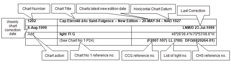
The last correction number is identified with the LNM/D or Last Notice to Mariners Number / Date.
Mariners are advised that only the most critical changes that directly affect safety to navigation are issued in “Section 2 – Chart Corrections.” This limitation is required to ensure that charts remain as clear and easy to read as possible. As a result, mariners may see minor discrepancies of a non-critical nature between information in official publications. For example, a small change in the nominal range or focal height of a light may not result in the production of a chart correction in Notices to Mariners, but may result in a correction in the List of Lights, Buoys and Fog Signals publication.
Note: In the case of a discrepancy between information provided on CHS charts relating to aids to navigation, and the List of Lights, Buoys and Fog Signals publication, the latter shall be deemed as containing the most up-to-date information.
Explanatory Notes – Marine Communications and Traffic Services (MCTS)
Navigational Warnings / Notices to Shipping
The Canadian Coast Guard (CCG) is implementing a number of changes to the aids to navigation system in Canada.
These changes are advertised as Navigational Warnings, formerly called Notices to ShippingFootnote 1, that are broadcast by the CCG, and are then followed up with Notices to Mariners, then charts are updated by hand correction, reprints or new editions.
Mariners are advised that all relevant Navigational Warnings (NAVWARN) should be kept until superseded by Notices to Mariners or through revised charts issued by the Canadian Hydrographic Service (CHS).
NAVWARN are accessible on the applicable regional page on the CCG Navigational Warnings.
CHS is reviewing the impact of these changes with CCG and together are preparing an action plan on the issuing of chart revisions.
For further information, contact your regional NAVWARN Issuing Desk.
Western Region
Prince Rupert MCTS Centre
“P” Series NAVWARN
Canadian Coast Guard
Bag 4444
Prince Rupert, BC V8J 4K2
Telephone: 250-627-3070
Email: NAVWARN.MCTSPrinceRupert@innav.gc.ca
Arctic Region
* Iqaluit MCTS Centre
Operational from approximately mid-May until late December.
“A” Series NAVWARN
Canadian Coast Guard
P.O. Box 189
Iqaluit, NU X0A 0H0
Telephone: 867-979-5269
Facsimile: 867-979-4264
Email: NAVWARN.MCTSIqaluit@innav.gc.ca
* Service available in English and French.
Index
Numerical Index of Canadian Charts Affected
This numerical index lists all nautical charts mentioned in this monthly edition of Notices to Mariners. Only charts appearing in Section 2 of this publication require a chart correction. The appearance of charts in all other sections, particularly those related to the correction of other nautical publications, is included here for reference.
| 3002 | 3548 | 3893 | 7082 |
| 3488 | 3673 | 3974 | 7777 |
| 3546 | 3886 | 3980 | 7778 |
SECTION 1 - GENERAL AND SAFETY INFORMATION
*505/23Canadian Hydrographic Service – Magnetic Declination Calculations
(Recurrent publication of notice *505/23, originally published in the Notices to Mariners – Monthly Western Edition 05/2023 publication.)
Mariners are advised that CHS has adopted the harmonized World Magnetic Model (WMM), as found on the NCEI/NOAA website. Old compass rose declination information on CHS navigational products can be updated using the Magnetic Declination Estimated Value website. While the differences in the model declinations are small each year, they can become more significant over a large period of time.
*1207/23Canadian Hydrographic Service – Inappropriate Geographical Names Review Process
(Recurrent publication of notice *1207/23, originally published in the Notices to Mariners – Monthly Western Edition 12/2023 publication.)
The records of the Canadian Hydrographic Service could contain geographical names that may be considered inappropriate, offensive and derogatory. Geographical naming authorities are in the process of addressing many offensive place names, the review process is underway. For more information, about inappropriate geographical names, please see the following announcement.
*208/24West Coast Haida Gwaii – Voluntary Protection Zone for Shipping
(Recurrent publication of notice *208/24, originally published in the Notices to Mariners – Monthly Western Edition 02/2024 publication.)
Reference: Notice *1105/21 is cancelled.
Voluntary Protection Zone for Shipping, western shore
of Haida Gwaii
(formerly Queen Charlotte Islands)
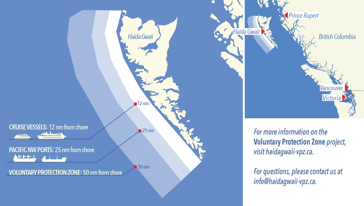
Haida Gwaii’s remote location, rugged coastline, variable sea and weather conditions, and rich ecological and cultural heritage make it vulnerable to the potential for pollution from shipping breakdowns and accidents. Increasing the distance vessels travel offshore can increase the amount of time available to address propulsion, steering or other issues, and the likelihood of a towing vessel being able to respond to a vessel in distress or drifting. This in turn reduces the risk of grounding and oil spills.
A Voluntary Protection Zone for Shipping on the western shore of Haida Gwaii is currently in effect. In the Voluntary Protection Zone, commercial vessels of 500 gross tonnage or greater are requested to observe a minimum distance of 50 nautical miles from the western shore of Haida Gwaii with the following exemptions:
Exemptions from requested 50 nm distance:
•Cruise vessels, which are asked to observe a minimum
12 nm distance from shore;
•Vessels transiting from Alaska to British Columbia or
Washington State, or vice versa, through the Voluntary
Protection Zone are asked to observe a distance of at least
25 nm from shore
•No minimum distance is requested for tugs and barges
(including pushing and towing alongside) or vessels engaged
in commercial fishing.
•Vessels to which this bulletin applies are not required to observe requested minimum distances if doing so may compromise navigational, vessel, passenger or cargo safety.
The Voluntary Protection Zone for Shipping coordinates are:
|
54⁰ 15.436' N |
133⁰ 04.788' W |
|
54⁰ 17.572' N |
134⁰ 02.484' W |
|
54⁰ 13.614' N |
134⁰ 19.427' W |
|
54⁰ 11.786' N |
134⁰ 30.841' W |
|
53⁰ 44.036' N |
134⁰ 32.677' W |
|
53⁰ 11.118' N |
134⁰ 16.412' W |
|
52⁰ 18.483' N |
133⁰ 20.917' W |
|
51⁰ 24.590' N |
132⁰ 04.081' W |
|
51⁰ 56.158' N |
131⁰ 01.830' W |
Vessels are requested to adhere to these distances on a voluntary basis and only when it does not jeopardize the safety of navigation, the vessel, the persons onboard, and the cargo.
*1105/24Transport Canada – British Columbia North Coast Waterway Management Guidelines
(Recurrent publication of notice *1105/24, originally published in the Notices to Mariners – Monthly Western Edition 11/2024 publication.)
Reference: Notice *1004/23 is cancelled.
The North Coast Waterway Management Guidelines are voluntary guidelines that aim to improve safety on the water by reducing conflicts between First Nations’ marine use activities, such as fishing and shoreline harvesting, and commercial vessels on the shipping route between Kitimat and Browning Entrance. The guidelines came into effect on September 1, 2022, and will be reviewed from time to time.
The guidelines apply to all vessels navigating on the route between Kitimat and Browning Entrance, on the north coast of British Columbia. This area includes:
|
•Douglas Channel |
•Otter Channel |
|
•Wright Sound |
•Nepean Sound, and |
|
•Lewis Passage |
•Principe Channel |
The
complete guidelines document is available at
British Columbia North Coast Waterway Management
Guidelines.
Nothing in these guidelines replaces or changes how we apply
any Canadian or international laws or regulations, including
the Collision Regulations. Furthermore, nothing in these
guidelines prevents or limits the master or pilot of a ship
from making any decisions to protect the vessel, the crew, or
the marine environment.

The guidelines include information for:
•all vessels that covers:
- inshore safety zones
- routing measures
- speed reductions
- guidelines for meeting and passing
- a special operating area in Wright Sound, and
- guidelines in case of a mechanical or electrical breakdown
•large commercial ships, including bulk carriers,
general cargo vessels, liquid bulk vessels, and passenger
vessels
•tugs and barges, and
•vessels operating in First Nations Areas of Concern where you must pay special attention to make sure local community users can transit and use the area safely.
*505/26Anguniaqvia Niqiqyuam Marine Protected AreaS (ANMPA), Tarium Niryutait Marine Protected Areas (TNMPA) and Beluga and Bowhead Whale Protection: Voluntary Avoidance and Slowdown Areas
(Recurrent publication of notice *505/26, originally published in the Notices to Mariners – Monthly Western Edition 05/2026 publication.)
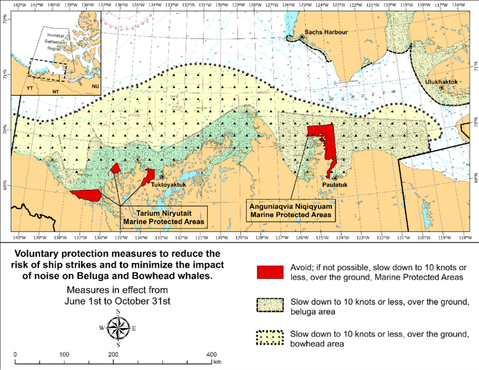
The two established Marine Protected Areas (MPAs) in Canada’s Western Arctic are located within the Inuvialuit Settlement Region, as such all activities must comply with the Inuvialuit Final Agreement. Protection and preservation of Arctic wildlife, the environment and biological productivity is one of the principles of the Inuvialuit Final Agreement and it is this principle that led the Inuvialuit Regional Corporation and the Inuvialuit Game Council to initiate establishment of the Western Arctic MPAs. The waters in and near the MPAs, and the offshore marine habitats of the Beaufort Sea and Amundsen Gulf, are important summer foraging habitats and travel routes used seasonally (May-October) by the Eastern Beaufort Sea beluga stock, and the Bering-Chukchi-Beaufort bowhead population.
REGULATORY PROTECTION MEASURES
All whale species are protected under the Marine Mammal
Regulations, pursuant to the Fisheries Act requiring
immediate reporting of accidental contact between a vehicle or
fishing gear and a marine mammal to the Minister. Within the
boundaries of the MPAs, a general prohibition is set out in the
Regulations, pursuant to the Oceans Act prohibiting
activities that disturb, damage, destroy or remove any living
marine organism from the areas. Any accident, including those
with a marine mammal within the Tarium Niryutait Marine
Protected Areas (TNMPA) must be reported within two hours after
its occurrence, to the Canadian Coast Guard. For marine
accidents such as collisions that occur within the Anguniaqvia
Niqiqyuam Marine Protected Areas (ANMPA) or outside the MPAs or
for any situation involving a marine mammal that is dead or in
trouble, report to the Fisheries and Oceans Canada, Inuvik
office at (867) 777-7500.
For more
information on the ANMPA and TNMPA, including local contacts
and species-specific minimum distances, see Section A2 -
Notices 5 and 5A.3 of the Notices to Mariners
Annual Edition.
VOLUNTARY PROTECTION MEASURES
Voluntary measures are in effect from June 1st
to October
31st. See map
above.
These measures apply to merchant vessels, cruise ships, small
vessels and adventure craft within the boundaries of the MPAs
and the additional identified areas to prevent collisions
with whales and to mitigate the underwater noise generated by
the vessels. These measures should only be taken when they
will not jeopardize navigational safety.
Avoid (red area): To reduce the risk of
underwater noise disturbance and collisions with whales
within the MPAs, vessels should avoid transiting through the
MPAs if possible. If passage through this area is necessary,
vessels should slow down to a speed not exceeding 10 knots
over the ground and post additional lookouts such as a marine
mammal observer in order to increase the chances of seeing
the whales and thus taking necessary measures to avoid them.
If bypassing the whales is not possible, slow down and wait
for the animals to move away to a distance greater than 400
metres (0.215 nautical miles) before resuming original speed
not exceeding 10 knots over the ground. It is more difficult
to see the animals in rain, fog, or in rough sea states,
therefore increased caution is recommended.
Slow down to 10 knots over the ground or less (yellow
areas): To reduce the risk of underwater noise
disturbance and collisions with whales within these areas, it
is recommended that vessels should slow down to a speed not
exceeding 10 knots over the ground, navigate within the
marked community supply channels and post additional
lookouts.
These voluntary measures are secondary to rights under the
Inuvialuit Final Agreement.
MPA Coordinates
The Tarium Niryutait Marine Protected Areas consist of three areas of the Mackenzie Bay: Okeevik, Kittigaryuit and Niaqunnaq. The three areas are bounded by straight lines and lines following the low water line which connect the following geographical coordinates [Universal Transverse Mercator (UTM) North America Datum 1983 (NAD 83)].
|
Okeevik Sub Area |
|||||
|
Point |
Latitude (North) |
Longitude (West) |
Point |
Latitude (North) |
Longitude (West) |
|
1 |
69° 38’ 19” |
135° 25’ 09” |
13 |
69° 28’ 35” |
135° 36’ 40” |
|
2 |
69° 38’ 03” |
135° 25’ 11” |
14 |
69° 28’ 39” |
135° 37’ 58” |
|
3 |
69° 37’ 46” |
135° 24’ 52” |
15 |
69° 30’ 34” |
135° 45’ 54” |
|
4 |
69° 29’ 49” |
135° 12’ 49” |
16 |
69° 35’ 18” |
135° 35’ 42” |
|
5 |
69° 30’ 45” |
135° 16’ 56” |
17 |
69° 36’ 00” |
135° 22’ 10” |
|
6 |
69° 29’ 26” |
135° 18’ 53” |
18 |
69° 34’ 40” |
135° 20’ 09” |
|
7 |
69° 29’ 23” |
135° 19’ 06” |
19 |
69° 34’ 00” |
135° 20’ 09” |
|
8 |
69° 28’ 07” |
135° 20’ 25” |
20 |
69° 34’ 00” |
135° 27’ 39” |
|
9 |
69° 27’ 36” |
135° 24’ 25” |
21 |
69° 36’ 00” |
135° 27’ 39” |
|
10 |
69° 25' 51” |
135° 32’ 27” |
22 |
69° 27’ 00” |
135° 31’ 11” |
|
11 |
69° 26’ 32” |
135° 34’ 54” |
23 |
69° 27’ 00” |
135° 34’ 45” |
|
12 |
69° 28’ 21” |
135° 35’ 24” |
|
|
|
|
Point |
Latitude (North) |
Longitude (West) |
Point |
Latitude (North) |
Longitude (West) |
|
1 |
69° 35’ 10” |
133° 48’ 26” |
12 |
69° 24’ 00” |
133° 59’ 10” |
|
2 |
69° 34’ 00” |
133° 28’ 00” |
13 |
69° 24’ 34” |
133° 53’ 49” |
|
3 |
69° 23’ 37” |
133° 26’ 40” |
14 |
69° 28’ 21” |
133° 48’ 15” |
|
4 |
69° 20’ 34” |
133° 40’ 37” |
15 |
69° 28’ 02” |
133° 50’ 59” |
|
5 |
69° 19’ 05” |
133° 42’ 21” |
16 |
69° 33’ 20” |
133° 47’ 29” |
|
6 |
69° 19’ 01” |
133° 42’ 31” |
17 |
69° 34’ 33” |
133° 47’ 42” |
|
7 |
69° 20’ 39” |
133° 43’ 20” |
18 |
69° 32’ 55” |
133° 51’ 09” |
|
8 |
69° 16’ 42” |
133° 54’ 54” |
19 |
69° 32’ 56” |
133° 51’ 54” |
|
9 |
69° 15’ 20” |
134° 06’ 53” |
20 |
69° 33’ 46” |
133° 55’ 48” |
|
10 |
69° 16’ 33” |
134° 05’ 56” |
21 |
69° 33’ 46” |
133° 55’ 31” |
|
11 |
69° 20’ 42” |
134° 02’ 44” |
|
|
|
|
Niaqunnaq Sub Area |
|||||
|
Point |
Latitude (North) |
Longitude (West) |
Point |
Latitude (North) |
Longitude (West) |
|
1 |
69° 08’ 00” |
136° 16’ 44” |
10 |
68° 54’ 22” |
136° 31’ 50” |
|
2 |
69° 04’ 25” |
136° 07’ 45” |
11 |
68° 55’ 00” |
136° 38’ 33” |
|
3 |
69° 03’ 43” |
136° 07’ 08” |
12 |
68° 56’ 15” |
137° 00’ 41” |
|
4 |
69° 01’ 19” |
136° 04’ 45” |
13 |
68° 56’ 29” |
137° 03’ 03” |
|
5 |
69° 01’ 14” |
136° 04’ 45” |
14 |
68° 55’ 48” |
137° 11’ 00” |
|
6 |
69° 00’ 57” |
136° 05’ 42” |
15 |
68° 57’ 50” |
137° 16’ 40” |
|
7 |
69° 00’ 12” |
136° 07’ 08” |
16 |
68° 59’ 20” |
137° 21’ 30” |
|
8 |
68° 57’ 00” |
136° 10’ 00” |
17 |
69° 03’ 09” |
137° 44’ 54” |
|
9 |
68° 55’ 00” |
136° 15’ 00” |
|
|
|
The Anguniaqvia Niqiqyuam Marine Protected Areas consist of two areas in Darnley Bay and Amundsen Gulf in the Beaufort Sea: Zone 1 and Zone 2. The areas consist of the seabed, the subsoil to a depth of five metres and the water column, including the sea ice. The two areas are bounded by straight lines and lines following the low water line which connect the following geographical coordinates [Universal Transverse Mercator (UTM) North America Datum 1983 (NAD 83)].
|
Zone 1 |
|
Zone 2 |
||||
|
Point |
Latitude (North) |
Longitude (West) |
|
Point |
Latitude (North) |
Longitude (West) |
|
A |
69° 21’ 07.8” |
124° 21’ 32.0” approx |
|
K |
70° 04’ 15.8” |
124° 41’ 51.0” approx |
|
B |
70° 12’ 00.0” approx |
124° 31’ 55.2” |
|
L |
70° 04’ 48.6” |
124° 41’ 54.0” approx |
|
C |
70° 08’ 22.0” |
124° 41’ 45.0” approx |
|
M |
70° 02’ 12.9” |
124° 35’ 23.0” approx |
|
D |
70° 09’ 09.9” |
124° 57’ 42.0” approx |
|
N |
70° 02’ 12.9” |
124° 35’ 29.0” approx |
|
E |
70° 09’ 13.0” approx |
125° 05’ 28.6” |
|
|
|
|
|
F |
70° 09’ 13.2” |
125° 17’ 53.0” |
|
|
|
|
|
G |
70° 20’ 00.0” |
125° 17’ 53.0” |
|
|
|
|
|
H |
70° 20’ 00.0” |
123° 54’ 17.5” |
|
|
|
|
|
I |
69° 37’ 20.6” |
123° 54’ 17.5” |
|
|
|
|
|
J |
69° 30’ 00.0” |
124° 15’ 34.7” |
|
|
|
|
*601/26Canadian Hydrographic Service – Nautical Charts
|
Charts |
Main Title |
Version Date |
Release Date |
|
Charts Permanently Withdrawn |
|||
|
3002 |
Queen Charlotte Sound to/à Dixon Entrance |
2026-05-29 |
|
*602/26Canadian Hydrographic Service – Electronic Navigational Charts
|
S-57 &
S-101 |
Chart Title |
Usage |
Published |
|
New Products |
|||
|
CA448HKA (Edn 1.000) |
Lake Superior - West of Coppermine Point |
TRANSIT |
2026-06-19 |
|
CA448HVA (Edn 1.000) |
CA448HVA |
TRANSIT |
2026-06-19 |
|
CA44JGYA (Edn 1.000) |
CA44JGYA |
TRANSIT |
2026-06-19 |
|
CA44JH9A (Edn 1.000) |
CA44JH9A |
TRANSIT |
2026-06-19 |
|
CA44JHKA (Edn 1.000) |
CA44JHKA |
TRANSIT |
2026-06-19 |
|
CA44JHVA (Edn 1.000) |
CA44JHVA |
TRANSIT |
2026-06-19 |
|
CA44UGCA (Edn 1.000) |
CA44UGCA |
TRANSIT |
2026-06-19 |
|
CA44UGNA (Edn 1.000) |
CA44UGNA |
TRANSIT |
2026-06-19 |
|
CA44UGYA (Edn 1.000) |
CA44UGYA |
TRANSIT |
2026-06-19 |
|
CA44UH9A (Edn 1.000) |
CA44UH9A |
TRANSIT |
2026-06-19 |
|
CA44UHKA (Edn 1.000) |
CA44UHKA |
TRANSIT |
2026-06-19 |
|
CA455GNA (Edn 1.000) |
CA455GNA_4900N08900W |
TRANSIT |
2026-06-19 |
|
CA4ALJGA (Edn 1.000) |
Transit6700N08300W |
TRANSIT |
2026-06-19 |
|
CA4ALJSA (Edn 1.000) |
Transit6700N08200W |
TRANSIT |
2026-06-19 |
|
CA4ALK3A (Edn 1.000) |
Transit6700N08100W |
TRANSIT |
2026-06-19 |
|
Transit6700N08000W |
TRANSIT |
2026-06-19 |
|
|
CA54EJ0A (Edn 1.000) |
CA54EJ0A |
PORT |
2026-06-19 |
|
CA54FJ0A (Edn 1.000) |
CA54FJ0A |
PORT |
2026-06-19 |
|
CA54JHXA (Edn 1.000) |
CA54JHXA |
PORT |
2026-06-19 |
|
CA54MHXA (Edn 1.000) |
CA54MHXA |
PORT |
2026-06-19 |
|
CA54PHVA (Edn 1.000) |
CA54PHVA |
PORT |
2026-06-19 |
|
CA54QHLA (Edn 1.000) |
CA54QHLA |
PORT |
2026-06-19 |
|
CA54QHMA (Edn 1.000) |
CA54QHMA |
PORT |
2026-06-19 |
|
CA54RHLA (Edn 1.000) |
CA54RHLA |
PORT |
2026-06-19 |
|
CA54RHMA (Edn 1.000) |
CA54RHMA |
PORT |
2026-06-19 |
|
CA54THVA (Edn 1.000) |
CA54THVA |
PORT |
2026-06-19 |
|
CA54THWA (Edn 1.000) |
CA54THWA |
PORT |
2026-06-19 |
|
CA551HFA (Edn 1.000) |
CA551HFA |
PORT |
2026-06-19 |
|
CA552H8A (Edn 1.000) |
CA552H8A |
PORT |
2026-06-19 |
|
CA552H9A (Edn 1.000) |
CA552H9A |
PORT |
2026-06-19 |
|
CA552HEA (Edn 1.000) |
CA552HEA |
PORT |
2026-06-19 |
|
CA552HFA (Edn 1.000) |
CA552HFA |
PORT |
2026-06-19 |
|
CA553H8A (Edn 1.000) |
CA553H8A |
PORT |
2026-06-19 |
|
CA553H9A (Edn 1.000) |
Port_4880N08700N |
PORT |
2026-06-19 |
|
CA554GVA (Edn 1.000) |
CA554GVA |
PORT |
2026-06-19 |
|
CA555GVA (Edn 1.000) |
CA555GVA |
PORT |
2026-06-19 |
|
New Editions |
|||
|
CA45FR5A (Edn 2.000) |
Transit5000N06100W |
TRANSIT |
2026-05-29 |
|
CA471023 (Edn 3.000) |
Kunghit Island |
TRANSIT |
2026-05-29 |
|
CA471141 (Edn 3.000) |
CA471141 |
TRANSIT |
2026-05-29 |
|
CA54PQYA (Edn 2.000) |
Port4750N06160W |
PORT |
2026-06-05 |
|
Charts Permanently Withdrawn |
|||
|
CA372006 |
Superior Shoal |
2026-06-19 |
|
|
CA373246 |
Caribou Island to Michipicoten Island |
2026-06-19 |
|
|
CA573270 |
Heron Bay |
2026-06-19 |
|
*603/26Canadian Hydrographic Service – Raster Digital Charts (BSB V3)
|
Charts |
Main Title |
Published |
|
Charts Permanently Withdrawn |
||
|
RM-3002 |
Queen Charlotte Sound to/à Dixon Entrance |
2026-05-29 |
*604/26Transport Canada - Ship Safety Bulletins #06, #07, #08, #09 and #10/2026
New Ship Safety Bulletins have recently been
posted on the
Transport Canada website.
To view or download these bulletins, please click on the
links below:
SSB#06/2026 – Coming into force
of the Vessel Traffic Services Zones Regulations
(SOR/2025-275)
SSB#07/2026 – 2026 Fire Hazard
Prevention Concentrated Inspection Campaign
SSB#08/2026 – Protecting killer
whales in the waters of southern British Columbia,
2026
SSB#09/2026 – Safety measures
concerning life-saving appliances
SSB#10/2026 – Now in force:
Discharge requirements for cruise ships
Sign up for
e-Bulletin to receive an e-mail notice each time a new
Ship Safety Bulletin is published on our website.
Contact us at marinesafety-securitemaritime@tc.gc.ca
or 1-855-859-3123 (Toll Free).
*605/26Canadian Coast Guard Publication - Amendments to the Notices to Mariners Annual Edition 2026 - Section A3, Notice 6: Ice Navigation, Routeing and Requests for Icebreaker Assistance
Page
1:
AMEND AS FOLLOWS:
1Hudson Strait and Canadian Arctic
Northern Canada Vessel Traffic Services (NORDREG) Zone
Mariners should be aware of the existence of the Northern
Canada Vessel Traffic Services Zone established by the
Northern Canada Vessel Traffic Services Zone
Regulations. These regulations require certain vessels
to report information to the Northern VTS before entering
the Northern VTS
zone and while navigating within it. In general, the
Northern VTS zone
covers the waters of Ungava Bay, Hudson Bay and James Bay and
Canada’s coastal northern waters within the area enclosed by
the 60th parallel of north latitude, the
141st meridian of west longitude and the outer
limit of the exclusive economic zone; however, where the
international boundary between Canada and Greenland is less
than 200 nautical miles from the baselines of the territorial
sea of Canada, the international boundary shall be
substituted for that outer limit.
Ice operations support in Northern VTS waterways is
provided by the Canadian Coast Guard. Icebreaker assistance
as well as ice information and ice routing should be
requested through Northern
VTS. For more detailed information on this VTS system,
the definition of waters it covers and the requirements to
make certain reports and obtain clearance, mariners should
refer to Part 3 of the Radio Aids to Marine Navigation
(Atlantic, St. Lawrence, Great Lakes,
Lake Winnipeg, Arctic and Pacific).
(a)For general information on ice conditions:
During Business Hours (0700-1900 Eastern Time
7-days/week):
Ice
Operations:
Telephone: 514-283-2784
Email : DFO.ICEOPS-ARCGLACE.MPO@dfo-mpo.gc.ca
Ice
Conditions:
Tel: (514) 283-1752
Email :ssgarctique-issarctic@ec.gc.ca
For After Hours Ice Information:
|
Address: |
Northern
VTS, |
1.1Ice Regime Routeing Message
Every message required by paragraph 9(1) of the ASSPPR must contain all designators listed in Table 2. The update message required by paragraph 9(2) of the ASSPPR must include designators A to K. Every message must be addressed to TRANSPORT CANADA and be provided to one of the Marine Communications and Traffic Services Centres that is designated by the Canadian Coast Guard to receive Northern VTS reports. The intended route described by designator G of Table 2 may include more than one Shipping Safety Control Zone.
Page
3:
AMEND AS FOLLOWS:
2East Coast, Estuary and Gulf of St. Lawrence
During the winter navigation season a similar service is provided to ships intending to transit or to operate in the East Coast and Gulf of St. Lawrence waters. Access to this service can be obtained by contacting the Eastern Canada Traffic System (Eastern VTS). Eastern VTS communications procedures are specified in the current Radio Aids to Navigation publications.
*606/26Canadian Coast Guard Publication - Amendments to the Notices to Mariners Annual Edition 2026 - Section A3, Notice 7: Information about Navigation in Ice
Page
3:
AMEND AS FOLLOWS:
7.4.1Entering the Ice
The route recommended by the Ice Superintendent through the appropriate reporting system i.e. Eastern VTS or Northern VTS, is based on the latest available information and Masters are advised to adjust their course accordingly. The following notes on ship-handling in ice have proven helpful:
*607/26Canadian Coast Guard Publication - Amendments to the Notices to Mariners Annual Edition 2026 - Section A3, Notice 7A: Voyage Planning for Vessels Intending to Navigate in Canada's Northern Waters
Page
2:
AMEND AS FOLLOWS:
5Ice Advisory Service, Northern VTS Reporting, and Sails Plans
The CCG operates an ice advisory service for the support of
vessels navigating in Canada’s northern waters during the
navigation season. Vessels can obtain up-to-date information on
ice conditions, advice on routes, aids to navigation and
icebreaker support, when available and considered necessary, by
contacting Northern Canada Vessel Traffic Services (Northern
VTS). Weather, ice
advisories, and forecasts are also broadcasted daily. Vessels
subject to the
Northern Canada Vessel Traffic Services Zone
Regulations must report to Northern VTS as required by the
regulations.
Vessels
not required to report to Northern VTS should, as a
minimum, file a sail plan with a responsible person. This
person should be instructed to call the Joint Rescue
Coordination Centre if the vessel becomes overdue. In
circumstances where it is not possible to file a sail plan
with a responsible person, a Sail Plan may be filed by
telephone, radio or in person, with a Marine Communications
and Traffic Services (MCTS)
Centre. While at sea, masters and operators who have filed a
sail plan are encouraged to file a daily position report
during long trips. After completion of the voyage, the vessel
must close (or deactivate) their sail plan. Forgetting to do
so can result in an unwarranted search.
All vessels to which Part 1 of the Arctic Shipping Safety
and Pollution Prevention Regulations (ASSPPR)
applies must report, as per section 9 of that regulation.
More information on this topic can be found in section 8 of
this notice.
The CCG publication
Radio Aids to Marine Navigation should be
consulted for further information including details on the
Northern VTS Zone,
reporting, radio frequencies and times for ship/shore
communications and broadcasts.
*608/26Canadian Coast Guard Publication - Amendments to the Notices to Mariners Annual Edition 2026 - Section A8, Notice 20: Safety of Offshore Exploration and Exploitation Vessels
Page
1:
AMEND AS FOLLOWS:
.4.1"Eastern
VTS" for East Coast waters,
.4.2"Northern
VTS" for Arctic waters,
.4.3"Marine Communications and Traffic Services Centre
(MCTS) Sarnia (Sarnia Traffic)" for Canadian Great Lakes
waters, and
.4.4"Western
VTS" for West Coast waters; and
Page 4:
AMEND AS FOLLOWS:
5Before entering an area of exploration and exploitation
5.1Mariners are advised to obtain up-to-date position reports on drilling vessels and production installations before entering an area of exploration or exploitation. This information is available by contacting, as appropriate, Eastern VTS, Northern VTS or Western VTS via any Marine Communications and Traffic Services Centre (MCTS).
*609/26Canadian
Hydrographic Service – Chart 3488 Partially Replaced by
New
Chart 3886
Chart 3488, Fraser River/Fleuve Fraser, Pattullo Bridge to/à Crescent Island, has been partially replaced by new chart 3486. The A-B panel has been cancelled. The remaining panel will be cancelled at a later date.
Reminder – Comment Period for Active Preliminary Notices
This is a reminder that the comment period is still open for the following active Preliminary notices:
|
Notice # |
Reference Chart # |
Aids Affected |
Intent of Notice |
|
Arctic Coast |
|||
|
7777 |
4488 |
Daybeacon to be Discontinued |
|
|
7778 |
List |
Daybeacons to be Discontinued |
|
Please refer to the Notices to Mariners - Monthly Summary of Temporary and Preliminary Notices publication for details.
Pacific Coast
Temporary Notices
No notices applicable for this edition.
Preliminary Notices
No notices applicable for this edition.
Arctic Coast
Temporary Notices
No notices applicable for this edition.
Preliminary Notices
No notices applicable for this edition.
SECTION 2 - CHART CORRECTIONS
3546 - Broughton Strait - New Edition - 15-APR-2005 - NAD 1983
(See Chart 1, I10)
(See Chart 1, I10)
3548 - Queen Charlotte Strait, Central Portion/Partie Centrale - New Edition - 26-SEP-1997 - NAD 1983
(See Chart 1, I10)
(See Chart 1, I10)
(See Chart 1, I10)
3673 - Clayoquot Sound, Tofino Inlet to/à Millar Channel - New Chart - 01-DEC-1995 - NAD 1983
Download Patch - https://www.notmar.gc.ca/chsftp/patches/3673_6205441_1_202605211118.pdf
Download Patch - https://www.notmar.gc.ca/chsftp/patches/3673_6205441_2_202605211119.pdf
3893 - Masset Inlet - New Chart - 13-JAN-1984 - NAD 1927
(See Chart 1, I10)
(See Chart 1, I10)
(See Chart 1, I10)
(See Chart 1, I10)
3974 - Continuation C - New Chart - 06-MAY-2011 - NAD 1983
3980 - Laredo Sound - New Chart - 13-JAN-2017 - World Geodetic System 1984
(See Chart 1, K11)
(See Chart 1, K11)
(See Chart 1, K11)
(See Chart 1, K48.2)
(See Chart 1, K11)
7082 - Cape Baring to/à Cambridge Bay - New Edition - 20-FEB-2004 - Unknown
(See Chart 1, Q81, S4)
(See Chart 1, Q81, S4)
(See Chart 1, Q81, S4)
(See Chart 1, Q81, S4)
7777 - Coronation Gulf Western Portion/Partie Ouest - New Edition - 15-MAY-2015 - World Geodetic System 1984
(See Chart 1, Q81, S4)
7778 - Coronation Gulf Eastern Portion/Partie Est - New Edition - 27-MAY-2022 - NAD 1983
(See Chart 1, Q81, S4)
(See Chart 1, Q81, S4)
(See Chart 1, Q81, S4)
7778 - Johansen Bay and/et Edinburgh Channel - New Edition - 27-MAY-2022 - NAD 1983
(See Chart 1, Q81, S4)
SECTION 3 - RADIO AIDS TO MARINE NAVIGATION CORRECTIONS
*620/26Radio Aids to Marine Navigation 2026 (Atlantic, St. Lawrence, Great Lakes, Lake Winnipeg, Arctic and Pacific)
ADD AS FOLLOWS:
1.1.3Discontinuation of NAVTEX Services at Ferndale and Pass Lake
Effective July 3, 2026, NAVTEX broadcasts will be discontinued at Ferndale and Pass Lake.
Page 2-36
DELETE AS FOLLOWS:
Table 2-15 - Prescott MCTS/VBR - Broadcasts
|
Time UTC |
Site |
Frequency or Channel |
Contents |
|
|
|
|
|
|
|
|
|
|
|
|
|
|
|
|
|
|
|
|
|
|
|
|
|
|
|
|
|
|
|
Continuous |
Cardinal |
Ch21B (2021) |
Radiotelephony (English)
•Localized
weather warnings/watches, marine weather statements,
technical marine synopsis, regular marine forecasts,
wave height forecast and extended marine forecasts for
St. Lawrence River from Kingston to Montréal and Lake
Ontario (Areas: 309, 401 and 402). •Ice forecast for Lake Ontario. |
|
… |
… |
… |
… |
DELETE AS FOLLOWS:
Table 2-22 - Sarnia MCTS/VBE - Broadcasts
|
Time UTC |
Site |
Frequency or Channel |
Contents |
|
|
|
|
|
|
|
|
|
|
|
|
|
|
|
|
|
|
|
|
|
|
|
|
|
|
|
|
|
|
|
Continuous |
Horn Sault Ste. Marie |
Ch21B (2021) |
Radiotelephony
•Weather
warning/watches, marine weather statements, technical
marine synopsis, regular marine forecasts, extended
marine forecast and wave height forecast for Lakes
Superior, Huron, St Clair and Erie and Georgian
Bay. •Ice forecast for Lakes Superior and Huron. |
|
… |
… |
… |
… |
DELETE AS FOLLOWS:
Table 4-13 - Transmitting Sites where NAVTEX Service is Available
|
Controlled by |
Site |
Position |
Range (NM) |
ID |
ID |
|
Placentia MCTS |
Robin Hood Bay |
47º36.65’N 052º40.18’W |
300 |
O |
- |
|
Labrador MCTS |
Cartwright |
53º42.52’N 057º01.35’W |
300 |
X |
- |
|
Sydney MCTS |
Port Caledonia |
46º11.15’N 059º53.77’W |
300 |
Q |
J |
|
Halifax MCTS |
Chebogue |
43º44.65’N 066º07.32’W |
300 |
U |
V |
|
Les Escoumins MCTS |
Moisie |
50º11.75’N 066º06.74’W |
300 |
C |
D |
|
|
|
|
|
|
|
|
|
|
|
|
|
|
|
Iqaluit MCTS |
Iqaluit |
63º43.82’N 068º32.70’W |
300 |
T |
S |
|
Prince Rupert MCTS |
Amphitrite Point |
48º55.28’N 125º32.38’W |
300 |
H |
- |
|
Prince Rupert MCTS |
Digby Island |
54º18.05’N 130º24.17’W |
300 |
D |
- |
Page 4-52
DELETE THE FOLLOWING FIGURE:
Figure 4-11c)Pass Lake
Page 4-53
DELETE THE FOLLOWING FIGURE:
Figure 4-11d)Ferndale
Page 4-61
DELETE AS FOLLOWS:
Figure 4-12b) Great Lakes Region
While the
indicated coverage footprint of NAVTEX transmitters located at
Pass Lake and Ferndale intersect over Lake Michigan,
information specifically pertaining to Lake Michigan waters is
not included on NAVTEX broadcasts.
DELETE AS FOLLOWS:
Table 5-49- Great Lakes: Production Schedule - NAVTEX Format
|
MCTS Centre |
NAVTEX Transmitter |
Header |
Issue Time |
|
|
|
|
|
|
|
|
|
|
Refer to Part
2 of this publication for
the MCTS broadcast schedule
Marine Weather Warnings (refer
to Table 5-1 -
Synoptic Warnings)
Note the following regional
particularities with respect to the regular program:
|
|
Warning Types |
Comments |
|
|
|
|
Page 5-49
DELETE AS FOLLOWS:
Table 5-60- Ice Bulletins: Production Schedule - NAVTEX Format
|
MCTS Centre |
NAVTEX Transmitter |
Header |
Issue Time |
|
Placentia / VCP |
Robin Hood Bay |
FICN33 CWIS |
21:50 UTC |
|
Sydney / VCO |
Port Caledonia |
FICN34 CWIS |
22:10 UTC |
|
Labrador / VOK |
Cartwright |
FICN35 CWIS |
23:20 UTC |
|
Iqaluit / VFF |
Iqaluit |
FICN36 CWIS |
06:30, 18:30 UTC |
|
Les Escoumins / VCF |
Moisie |
FICN37 CWIS |
14:50 UTC |
|
|
|
|
|
|
|
|
|
|
Refer to Part 2 of this publication for the MCTS broadcast schedule
SECTION 4 - CANADIAN SAILING DIRECTIONS CORRECTIONS
The following Canadian Sailing Directions volumes have recently been updated on the Canadian Hydrographic Service website.
|
No. |
Title |
|
Atlantic Coast |
|
|
ATL 108 |
Gulf of St. Lawrence (Southwest Portion) |
|
Central Canada |
|
|
CEN 305 |
Lake Huron, St. Marys River, Lake Superior |
|
CEN 308 |
Rideau Canal and Ottawa River |
|
Pacific Coast |
|
|
PAC 200 |
General Information, Pacific Coast |
Each volume includes a section entitled “Record of Changes” which lists all updates that are incorporated during the current calendar year.
SECTION 5 - LIST OF LIGHTS, BUOYS AND FOG SIGNALS CORRECTIONS
The amendments are highlighted and deletions are crossed out. For general and region-specific
information on the List of Lights, click on the following links:
Newfoundland and Labrador Coast,
Atlantic Coast,
Inland Waters and
Pacific Coast.
Pacific Coast
| No. ----- Intl No. |
Name ----- RACON |
Location ----- Latitude N. Longitude W. |
Light Characteristics |
Focal Height Above Water (m) |
Nominal Range (NM) |
Description ----- Height of Structure Above Ground Level (m) |
Remarks ----- Audible Signals ----- AIS |
|||
|---|---|---|---|---|---|---|---|---|---|---|
| DISCOVERY PASSAGE (LL 511 - 517.5) | ||||||||||
| 511.1 |
Cape Mudge North Sector Light |
50 00 01.1 125 11 50.0 |
F |
R W |
..... |
7.2 |
9 |
White square tower with red bands at top and bottom. |
Year round. Operates 24 h. R 144°-149°; W 149°-151°. |
|
| HAIDA GWAII (LL 768.6 - 812) | ||||||||||
| 795 G5845 |
Sloop Islet |
On Islet. 53 45 27.9 132 14 41.7 |
Fl |
W |
6s |
6.6 |
5 |
White square tower. |
Year round. Flash 0.5 s; eclipse 5.5 s. |
|
| 795.3 |
Port Clements Breakwater |
53 41 25.2 132 10 56.8 |
Q |
R |
1s |
5.4 |
4 |
Square skeleton tower, red and white rectangular daymark. |
Year round. |
|
| 796 G5846 |
Dawson Islands |
On easternmost island. 53 42 57.4 132 20 16.1 |
Fl |
W |
4s |
9.1 |
3 |
White square skeleton tower. |
Year round. |
|
Arctic Coast
| No. ----- Intl No. |
Name ----- RACON |
Location ----- Latitude N. Longitude W. |
Light Characteristics |
Focal Height Above Water (m) |
Nominal Range (NM) |
Description ----- Height of Structure Above Ground Level (m) |
Remarks ----- Audible Signals ----- AIS |
|||
|---|---|---|---|---|---|---|---|---|---|---|
| WESTERN ARCTIC (LL 745 - 795) | ||||||||||
| 780 |
Cambridge Bay Front Range 1 Light |
In bay. 69 02 23.4 104 54 59.2 |
F |
Y |
..... |
13.9 |
14 |
Tripod skeleton tower, red daymark with white vertical stripe. |
Seasonal (in place year round). Radar reflector. |
|
| 781 |
Cambridge Bay Rear Range 1 Light |
69 02 19.4 104 53 01.4 095°32' 1313.5 m from front. |
F |
Y |
..... |
19.0 |
14 |
Tripod skeleton tower, red daymark with white vertical stripe. |
Seasonal (in place year round). Radar reflector. |
|
| 790 |
Cambridge Bay Front Range 3 Light |
In bay. 69 02 55.9 104 54 36.4 |
F |
Y |
..... |
5.0 |
14 |
Square skeleton tower, red daymark with white vertical stripe. |
Seasonal (in place year round). |
|
| 791 |
Cambridge Bay Rear Range 3 Light |
69 02 19.4 104 53 01.4 136°50' 1545.8 m from front. |
F |
Y |
..... |
18.0 |
14 |
Tripod skeleton tower, red daymark with white vertical stripe. |
Seasonal (in place year round). Radar reflector. |
|
| NUNATSIAVUT (LL 1345 - 1900) | ||||||||||
| 1461 H0060.051 |
Uigortlek Island Rear Range Light |
56 24 50.8 061 16 06.2 109°30' 154.0 m from front. |
Fl |
G |
4s |
25.6 |
..... |
Square skeleton tower, white daymark with red vertical stripe. |
Private aid. Year round. The operation of the lights will be made remotely on channel 65A (156.275 MHz). Mariners requiring the operation of the light will have to key the microphone of the VHF radio five consecutive times at 5 second intervals on channel 65A to turn the light on. The light can be deactivated by keying the microphone of the VHF radio three times at 5 second intervals. The light can be activated within 5 nautical miles range. |
|
| 1465 H0060.155 |
Mount Pickle Sector Light |
56 23 12.4 061 11 34.8 |
F |
R W G |
..... |
35.2 |
..... |
Square skeleton tower, red and white rectangular daymark. |
Private aid. Year round. Operates 24 h. The operation of the lights will be made remotely on channel 65A (156.275 MHz). Mariners requiring the operation of the light will have to key the microphone of the VHF radio five consecutive times at 5 second intervals on channel 65A to turn the light on. The light can be deactivated by keying the microphone of the VHF radio three times at 5 second intervals. The light can be activated within 5 nautical mile range. |
|
| 1466 H0060.141 |
Unknown Island Rear Range Light |
56 22 08.6 061 09 28.4 204°40' 266.0 m from front. |
Fl |
G |
4s |
22.9 |
..... |
Square skeleton tower, white daymark with red vertical stripe. |
Private aid. Year round. Operates 24 h. The operation of the lights will be made remotely on channel 65A (156.275 MHz). Mariners requiring the operation of the light will have to key the microphone of the VHF radio five consecutive times at 5 second intervals on channel 65A to turn the light on. The light can be deactivated by keying the microphone of the VHF radio three times at 5 second intervals. The light can be activated within 5 nautical mile range. |
|
Report a problem on this page
- Date modified: