

Notices to Mariners
August 28, 2026
Safety First, Service Always
Monthly Eastern Edition
CONTENTS
| Section 1 | General and Safety Information |
| Section 1A | Temporary and Preliminary Notices |
| Section 2 | Chart Corrections |
| Section 3 | Radio Aids to Marine Navigation Corrections |
| Section 4 | Canadian Sailing Directions Corrections |
| Section 5 | List of Lights, Buoys and Fog Signals Corrections |
Notices to Mariners – Monthly Eastern Edition
Edition No. 08/2026
Aussi disponible en français :
Avis aux navigateurs – Édition mensuelle de l’Est
Édition n° 08/2026
Published under the Authority of:
Canadian Coast Guard Programs
Aids to Navigation and Waterways
Montreal, QC H2Y 2E7
For more information, contact DFO.Notmar-Notmar.MPO@dfo-mpo.gc.ca.
© His Majesty the King in Right of Canada,
as represented by the Canadian Coast Guard, 2026.
Cat. No. D16-2E-PDF (Electronic PDF, English)
ISSN 2817-0075
Cat. No. D16-2F-PDF (Electronic PDF, French)
ISSN 2817-0083

Explanatory Notes – Notices to Mariners (NOTMAR)
Geographical positions refer directly to the graduations of the largest scale Canadian Hydrographic Service chart (unless otherwise indicated).
Bearings refer to the true compass and are measured clockwise from 000° (North) clockwise to 359°; those relating to lights are from seaward.
Visibility of lights is that in clear weather.
Depths - The units used for soundings (metres, fathoms or feet) are stated in the title of each chart.
Elevations are normally given above Higher High Water, Large Tide (unless otherwise indicated).
Distances may be calculated as follows:
1 nautical mile = 1,852 metres (6,076.1 feet)
1 statute mile = 1,609.3 metres (5,280 feet)
1 metre = 3.28 feet
Temporary and Preliminary Notices to Mariners – Section 1A of Notices to Mariners
These notices are indicated by a (T) or a (P), respectively. Please note that nautical charts are not amended by the Canadian Hydrographic Service for temporary (T) and preliminary (P) notices. It is recommended that mariners chart these corrections in pencil. For the list of charts affected by (T) & (P) notices, please refer to the current Notices to Mariners - Monthly Summary of Temporary and Preliminary Notices publication.
Suggestions and Corrections Form
This form is specifically for suggestions and corrections to Notices to Mariners publications. It is available online and also in fillable PDF format included with the monthly publication ZIP file.
To submit comments and suggestions on possible improvements to the various publications and services: DFO.Notmar-Notmar.MPO@dfo-mpo.gc.ca.
To report chart discrepancies and/or corrections to the Canadian Sailing Directions booklets: Fill out the Marine Information Reporting Form and/or email chsinfo@dfo-mpo.gc.ca.
To report emergencies or navigational hazards: Contact your nearest MCTS centre
- VHF channel 16 (156.8 MHz)
- MF/HF frequency 2182 kHz/4125 kHz (where available)
- ∗16 on a cellphone (where available)
NOTMAR Website – Monthly Editions, Chart Corrections and Chart Patches
The NOTMAR website allows users to access the monthly publications,
chart corrections, and chart patches.
Users can subscribe for free to the email notification service
to receive notifications when charts of interest are updated, including their patches, as well as when a new Monthly Edition of Notices to Mariners is published.
In addition, the monthly publication and related
files to download, such as chart patches, can be obtained
all together through the download of a single ZIP file.
Explanatory Notes – Canadian Hydrographic Service (CHS)
Chart Corrections – Section 2 of Notices to Mariners
Corrections to nautical charts will be listed in numerical order by chart number. Each chart correction listed applies only to that particular chart. Related charts, if any, will have their own specific correction listed separately.
Users should also refer to CHS Chart 1: Symbols, Abbreviations and Terms for additional information pertaining to the correction of charts.
The illustration below describes the elements that will comprise a typical Section 2 chart correction:
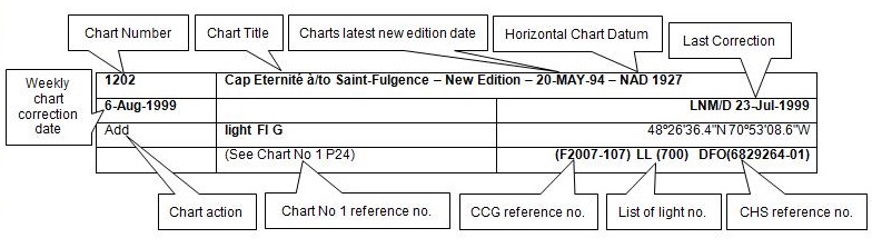
The last correction number is identified with the LNM/D or Last Notice to Mariners Number / Date.
Mariners are advised that only the most critical changes that directly affect safety to navigation are issued in “Section 2 – Chart Corrections.” This limitation is required to ensure that charts remain as clear and easy to read as possible. As a result, mariners may see minor discrepancies of a non-critical nature between information in official publications. For example, a small change in the nominal range or focal height of a light may not result in the production of a chart correction in Notices to Mariners, but may result in a correction in the List of Lights, Buoys and Fog Signals publication.
Note: In the case of a discrepancy between information provided on CHS charts relating to aids to navigation, and the List of Lights, Buoys and Fog Signals publication, the latter shall be deemed as containing the most up-to-date information.
Explanatory Notes – Marine Communications and Traffic Services (MCTS)
Navigational Warnings / Notices to Shipping
The Canadian Coast Guard (CCG) is implementing a number of changes to the aids to navigation system in Canada.
These changes are advertised as Navigational Warnings, formerly called Notices to ShippingFootnote 1, that are broadcast by the CCG, and are then followed up with Notices to Mariners, then charts are updated by hand correction, reprints or new editions.
Mariners are advised that all relevant Navigational Warnings (NAVWARN) should be kept until superseded by Notices to Mariners or through revised charts issued by the Canadian Hydrographic Service (CHS).
NAVWARN are accessible on the applicable regional page on the CCG Navigational Warnings.
CHS is reviewing the impact of these changes with CCG and together are preparing an action plan on the issuing of chart revisions.
For further information, contact your regional NAVWARN Issuing Desk.
Atlantic Region (North)
* Port aux Basques MCTS Centre
“N” Series NAVWARN
Canadian Coast Guard
49 Stadium Rd.
P.O. Box 99
Port aux Basques, NL A0M 1C0
Telephone: 709-695-2168 or 1-800-563-9089
Facsimile: 709-695-7784
Email: NAVWARN.MCTSPortAuxBasques@innav.gc.ca
Central Region
* Prescott MCTS Centre
“C” Series NAVWARN
Canadian Coast Guard
401 King Street West
P.O. Box 1000
Prescott, ON K0E 1T0
Telephone: 613-925-0666
Facsimile: 613-925-4519
Email: NAVWARN.MCTSPrescott@innav.gc.ca
Atlantic Region (South)
* Sydney MCTS Centre
“M” Series NAVWARN
Canadian Coast Guard
1190 Westmount Road
Sydney, NS B1R 2J6
Telephone: 902-564-7751 or 1-800-686-8676
Facsimile: 902-564-7662
Email: NAVWARN.MCTSSydney@innav.gc.ca
Arctic Region
* Iqaluit MCTS Centre
Operational from approximately mid-May until late December.
“A” Series NAVWARN
Canadian Coast Guard
P.O. Box 189
Iqaluit, NU X0A 0H0
Telephone: 867-979-5269
Facsimile: 867-979-4264
Email: NAVWARN.MCTSIqaluit@innav.gc.ca
* Service available in English and French.
Index
Numerical Index of Canadian Charts Affected
This numerical index lists all nautical charts mentioned in this monthly edition of Notices to Mariners. Only charts appearing in Section 2 of this publication require a chart correction. The appearance of charts in all other sections, particularly those related to the correction of other nautical publications, is included here for reference.
| 1310 | 2312 | 4486 | 5001 |
| 1311 | 3489 | 4615 | 5628 |
| 1313 | 3654 | 4722 | 5629 |
| 1315 | 4023 | 4906 | 5720 |
| 1316 | 4243 | 4909 | 6258 |
| 1317 | 4244 | 4911 | 6259 |
| 1429 | 4266 | 4913 | 6730 |
| 1430 | 4276 | 4920 | 7787 |
| 1550 | 4367 | 4935 | 7791 |
| 1554 | 4416 | 4937 | |
| 2067 | 4425 | 4958 |
SECTION 1 - GENERAL AND SAFETY INFORMATION
*505/23Canadian Hydrographic Service – Magnetic Declination Calculations
(Recurrent publication of notice *505/23, originally published in the Notices to Mariners – Monthly Eastern Edition 05/2023 publication.)
Mariners are advised that CHS has adopted the harmonized World Magnetic Model (WMM), as found on the NCEI/NOAA website. Old compass rose declination information on CHS navigational products can be updated using this website: https://www.ngdc.noaa.gov/geomag/calculators/magcalc.shtml#declination. While the differences in the model declinations are small each year, they can become more significant over a large period of time.
*1207/23Canadian Hydrographic Service – Inappropriate Geographical Names Review Process
(Recurrent publication of notice *1207/23, originally published in the Notices to Mariners – Monthly Eastern Edition 12/2023 publication.)
The records of the Canadian Hydrographic Service could contain geographical names that may be considered inappropriate, offensive and derogatory. Geographical naming authorities are in the process of addressing many offensive place names, the review process is underway. For more information, about inappropriate geographical names, please see the following announcement.
*401/26Protecting the North Atlantic Right Whale: Speed Restriction Measures in the Gulf of St. Lawrence
(Recurrent publication of notice *401/26, originally
published in the Notices to Mariners – Monthly Eastern Edition
04/2026 publication.)
Purpose
This notice describes the speed and navigational restriction
zones that vessels must follow in the Gulf of St.
Lawrence.
The Government of Canada has established these zones to
reduce the risk of vessels colliding with North Atlantic
right whales (NARW).
Background
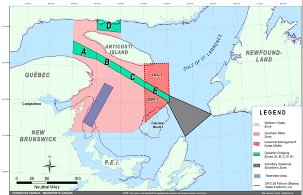
Due to changing migration patterns of NARW and their increased presence in the Gulf of St. Lawrence, the Government of Canada has set seasonal speed restrictions in specific zones. These speed restrictions zones are defined as “static zones”, “dynamic shipping zones”, “seasonal management areas”, a “voluntary seasonal slowdown zone” and a “restricted area”. See the map below for details.
Note: Vessels must follow Navigational Warnings outlining the speed restrictions. The Interim Order for the Protection of North Atlantic Right Whales (Eubalaena Glacialis) in the Gulf of St. Lawrence, 2026, enables the issuance of Navigational Warnings (NAVWARNs) imposing speed restrictions and navigation restrictions.
Speed restriction zones are described in monthly Notices to Mariners (NOTMARs), which are published by the Canadian Coast Guard. The status of these zones is broadcast through NAVWARNs, which are published by the Coast Guard’s Marine Communications and Traffic Services Centres.
Speed restriction zones and measures
The speed restriction zones will be effective from April 22,
2026, while the restricted area will be implemented based on
whale presence.
Please check the latest
NAVWARN for all speed restrictions currently in effect.
Speed Restriction Measures for 2026
These restrictions are in effect from April 22 to November 15, 2026.
Non-application
The measures described in this bulletin do not apply to:
a)a vessel in
distress or providing assistance to a person or a vessel in
distress;
b)a government
vessel being used
(i)for law enforcement activities;
(ii)for search and rescue operations; or
(iii)to ensure the competency of the crew or the operational readiness of the vessel or crew with respect to such activities or operations.
Static zones
In the static zones, all vessels above 13.0 m in length overall (LOA) must proceed at a speed of not more than 10.0 knots over the ground.
Exclusions
Air cushion vessels operated by or on behalf of the Government of Canada that are engaged in ice-clearing activities from April to June in and around Chaleur Bay are exempted when in operation.
36.57 m (20-fathoms) shallow water protocol exclusion
Vessels engaged in any commercial fishing activity may proceed at a safe operational speed in waters not more than 36.57 m (20 fathom) deep within the static zones.
If a NAVWARN states that at least one North Atlantic right whale has been detected in waters within a static zone or its buffer zone that are not more than 36.57 m deep, the speed limit of 10.0 knots over the ground will apply in the concerned zone(s) to all vessels engaged in commercial fishing activities above 13.0 m in length overall (LOA). The speed restriction will be in effect for 15 days after the day on which the whale was detected. In the event of a new North Atlantic right whale detection occurring in the last 7 days of the 15-day slowdown period, the speed restriction will be extended for an additional 15 days from the date of the new detection. This would continue until no North Atlantic right whales are detected. The buffer zones associated with the static zones are located 5 nautical miles north and south of their adjacent border in waters less than 36.57 m deep.
|
Coordinates for the northern static zone:
•50° 20’ N 065° 00’ W |
Coordinates for the southern static zone:
•48° 40’ N 065° 00’ W |
Dynamic shipping zones
There are five dynamic shipping zones (DSZ) located in the Traffic Separation Scheme (TSS) north and south of Anticosti Island: A, B, C, D and E.
Speed restrictions in the dynamic shipping zones
When a North Atlantic right whale is detected in a dynamic shipping zone or in the buffer zones, located 5 nautical miles south or 2.5 nautical miles from the eastern and western edges of the dynamic shipping zones:
•All vessels will be notified via a NAVWARN; and
•Vessels above 13.0 m in length overall (LOA) must proceed at a speed of not more than 10.0 knots over the ground within that zone.
When a NAVWARN is issued implementing a speed restriction in one or more dynamic shipping zone(s), vessels above 13.0 m in length (LOA) must not exceed a speed of 10.0 knots over the ground. Even though dynamic shipping zones overlap with static zones, vessels can travel at a safe operational speed in dynamic shipping zones when they are not under speed restriction. Mariners are encouraged to take into consideration the potential for their vessel striking North Atlantic right whales when considering a safe operational speed during navigation.
The speed restriction in the dynamic shipping zone(s) will be in effect for 15 days from the date of detection. In the event of a new North Atlantic right whale detection occurring in the last 7 days of the 15-day slowdown period, the speed restriction will be extended for an additional 15 days from the date of the new detection. This would continue until no NARW are detected. When a speed restriction is extended due to a new North Atlantic right whale detection, it should be noted that, contrary to previous years’ operations, no new NAVWARN will be issued. The initial NAVWARN will remain in place until a NAVWARN lifting the speed restriction is published.
Coordinates for the dynamic shipping zones:
|
Zone A
•49⁰ 41’ N, 065⁰ 00’ W |
Zone B
•49⁰ 22’ N, 064⁰ 00’ W |
Zone C
•49⁰ 00’ N, 063⁰ 00’ W |
|
Zone D
•50⁰ 16’ N, 064⁰ 00’ W |
Zone E
•48⁰ 35’ N 062⁰ 00’ W |
|
Seasonal management areas
Seasonal management area 1 (SMA-1) and seasonal management area
2 (SMA-2) are speed restriction areas located north and south
of dynamic shipping zone E, respectively.
Within seasonal management areas, vessels above 13.0
m in length (LOA):
•Must restrict their speed so as not to exceed 10.0 knots over the ground from April 22 to June 30, 2026; and
•Are allowed to proceed at a safe operational speed from July 1 to November 15, 2026, unless a North Atlantic right whale is detected. If a whale is detected, a speed restriction of 10.0 knots over the ground will be triggered for 15 days from the date of detection. In the event of a new North Atlantic right whale detection occurring in the last 7 days of the 15-day slowdown period, the speed restriction will be extended for an additional 15 days from the date of the new detection. This would continue until no North Atlantic right whales are detected.
|
Coordinates for the SMA-1:
•49° 04’ N 062° 00’ W |
Coordinates for the SMA-2:
•48° 24’ N 062° 00’ W |
Restricted area
In the summer months, an important proportion of the total North Atlantic right whale population gathers for feeding and surface activity near the Shediac Valley. Since this makes the North Atlantic right whale more susceptible to vessel collisions, a mandatory restricted area will be implemented in and near the Shediac Valley and will come into force once 80% of the restricted area is closed to fishing for the season as per the Department of Fisheries and Oceans’ (DFO) right whale closure protocol, or at the latest on June 15, 2026. The restricted area will be lifted on September 25, 2026, unless North Atlantic right whale detections are reported in high number, which would extend the restricted area beyond September 25.
The size and location of the area are determined based on historical detection data of North Atlantic right whales. All necessary details can be found in the Interim Order for the Protection of North Atlantic Right Whales (Eubalaena Glacialis) in the Gulf of St. Lawrence, 2026. Triggering and lifting of the restricted area will be communicated to mariners through NAVWARNs and notices to fish harvesters.
Vessels above 13.0 m in length (LOA) will be required to:
•Avoid the area unless they are part of the exceptions listed in the Interim Order for the Protection of North Atlantic Right Whales (Eubalaena Glacialis) in the Gulf of St. Lawrence, 2026;
•Transit the area at a speed not exceeding 8.0 knots over the ground if they are part of the exceptions.
The following exceptions will apply to the restricted area. The following listed vessels can travel through the area at not more than 8.0 knots over the ground:
•A vessel being used for commercial fishing;
•A vessel being used for fishing under the authority
of a licence issued under the Aboriginal Communal Fishing
Licences Regulations;
•A vessel being used for research purposes on behalf
of the Government of Canada
•A vessel involved in research relating to right
whales as part of a project that has received funding from
the Government of Canada;
•A vessel being used as part of the Department of
Fisheries and Oceans’ Marine Mammal Response Program to
assist a marine mammal or sea turtle in distress or to access
or retrieve a deceased marine mammal or sea turtle;
•A vessel authorized by the Government of Canada to
retrieve or identify the location of abandoned or lost
fishing gear;
•A vessel involved in pollution response
operations;
•A vessel avoiding immediate or unforeseen danger; or
•A vessel being used to conduct the maintenance or repair of underwater communication cables.
The following vessels can travel through the restricted area at a speed over 8.0 knots, but below 10.0 knots over the ground as required by the static speed restriction zone:
•A vessel being used by an employee of the Government of Canada or peace officer who is performing their duties.
Coordinates for the restricted area:
•48°31.8’ N 063°39.6’ W
•48°24.72’ N 063°17.88’ W
•47°18.84’ N 064°10.8’ W
•47°27.18’ N 064°30.72’ W
Report of death or injury
In the event that at least one North Atlantic right whale is reported dead or injured in the Gulf of St. Lawrence in a zone or area where there is no NAVWARN in effect, a speed restriction of 10.0 knots over the ground for vessels above 13.0 m in length overall (LOA) will be implemented in the concerned zone(s) or area(s) for 15 days from the time the NAVWARN comes into effect.
Inclement weather exception
Mariners will be notified in advance via a NAVWARN should the speed restriction status change in any zone or area, due to inclement weather.
Within any zone or area that is no longer subject to a speed restriction due to adverse weather conditions, mariners may proceed at a safe operational speed, but are encouraged to take into consideration the potential for their vessel striking North Atlantic right whales when determining that speed during navigation.
*Non-excepted vessels are still prohibited from transiting through the restricted area.
Voluntary seasonal slowdown in Cabot Strait
To coincide with the North Atlantic right whales entering and exiting the Gulf of St. Lawrence in large numbers, a voluntary seasonal slowdown is being put in place in Cabot Strait from April 22 to June 30, 2026, and from September 2 to November 15, 2026.
•During these periods, vessels above 13 m in length (LOA) are requested to voluntarily reduce their speed so as to not exceed 10.0 knots over the ground.
Voluntary seasonal slowdown zone coordinates:
•48° 10.5’ N 061° 00’ W
•47° 37.2’ N 059° 18.5’ W
•47° 02’ N 060° 23.7’ W
•47° 58.1’ N 061° 03.5’ W
•48° 00’ N 061° 00’ W
Map of the Gulf of St. Lawrence
The map below provides a visual representation of the main zones mentioned. It must not be used for navigation or law enforcement purposes.
•Static zones (north and south), in pink;
•Dynamic shipping zones (A, B, C, D and E), in
green;
•Seasonal management areas, in dark pink;
•Voluntary seasonal slowdown zone, in grey;
•Restricted area, in dark blue; and
•36.57 m (20 fathoms) DFO shallow water protocol line.
Roseway Basin – Area to be Avoided
The Roseway Basin, located approximately 20 nautical miles south of Cape Sable Island, Nova Scotia, is a critical habitat for North Atlantic right whales, which have been observed to gather in the area on a seasonal basis in Canadian waters. This critical habitat is also located near key shipping routes. In 2007, Canada, with the support of many groups with varied interests, proposed to the International Maritime Organization (IMO) the establishment of a seasonal Area to be Avoided in the Roseway Basin to protect North Atlantic right whales, which IMO accepted and adopted.
To reduce the risk of vessels colliding with North Atlantic right whales, it is recommended that vessels of 300 gross tonnages and more, in transit during the period of June 1 through December 31, avoid the Roseway Basin area. Smaller vessels are also encouraged to avoid passage through this area. If passage is necessary within the Area to be Avoided, it is recommended that all mariners decrease their vessel speed to no more than 10 knots, when safe to do so.
Roseway Basin coordinates:
•43° 16’ N 064° 55’ W
•42° 47’ N 064° 59’ W
•42° 39’ N 065° 31’ W
•42° 52’ N 066° 05’ W
Bay of Fundy – Voluntary Slowdown
The Grand Manan Basin located in the Bay of Fundy is identified as a critical habitat for the North Atlantic right whale. When North Atlantic right whales are detected in the Bay of Fundy shipping lanes and near the Grand Manan Basin area (see sectors 1 and 2 on Canadian Coast Guard’s map), the Bay of Fundy Vessel Traffic Services will ask vessels to voluntarily slowdown to 10 knots via VHF channel 12 or 14 at corresponding Calling-in-Points.
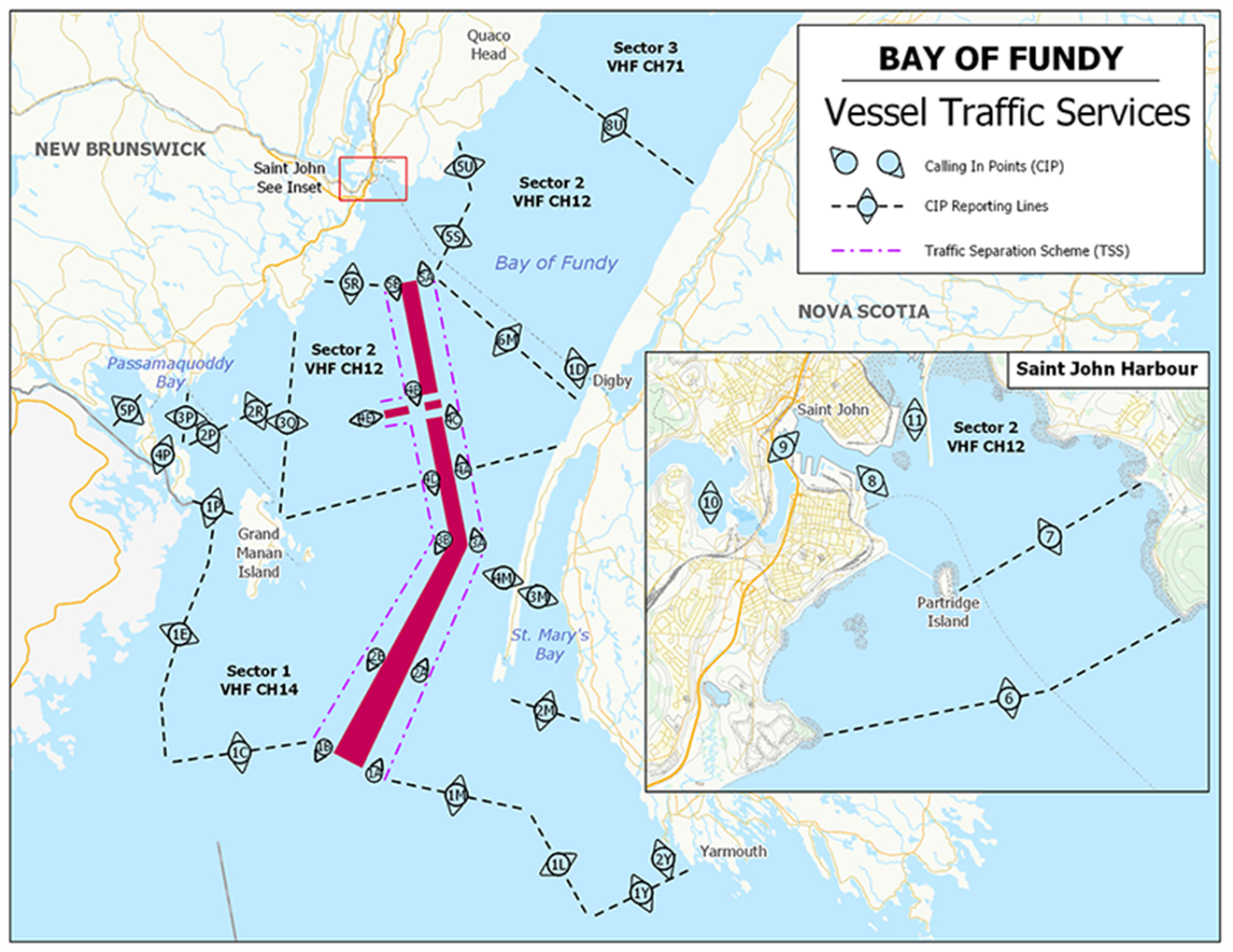
This map is for visual representation only and is not to be used for navigation or enforcement.
NAVWARN broadcasts
The Canadian Coast Guard’s Marine Communications and Traffic Services Centres (MCTS) issue NAVWARNs:
•By radio broadcast: for marine radio, Continuous Marine Broadcast frequencies and scheduled broadcast times, information may be found in the Radio Aids to Marine Navigation publication; and
•Online: at Canada’s Maritime Information Portal and its Navigational Warnings site, using the North Atlantic Right Whale search term or category.
Mariners must ensure they have accurate and up-to-date information about the protection of the North Atlantic right whale, as in all applicable NOTMARs and NAVWARNs.
Outbound vessels will receive NAVWARNs
•at Calling-in-Point 10 (St-Laurent); or
•upon a departure downstream from the Quebec pilot station (including the Saguenay River, Chaleur Bay, Miramichi Bay, etc.).
Inbound vessels will receive NAVWARNs
•when a clearance to enter Canadian waters is granted.
Vessels in transit will receive NAVWARNs
•at the last reporting point prior to entering the mandatory speed restriction zones;
•vessels in transit will confirm they have received NAVWARNs.
MCTS Centres will broadcast NAVWARNs continuously throughout the season on Continuous Marine Broadcast.
It should be noted that, contrary to previous years’ operations, reminders sent to vessels in transit 10 nautical miles before entering a speed restriction zone will no longer be transmitted.
Vessel operators are required to monitor broadcasts by the Canadian Coast Guard’s Marine Communications and Traffic Services network for the most up to date information.
Aids to navigation
The Canadian Coast Guard broadcasts virtual Automatic
Identification System (AIS) aids to navigation (AIS AtoN) in
specific areas. These aids may notify mariners of dynamic
shipping zones and/or seasonal management areas subject to
speed restrictions.
Each zone is delimited by four to six virtual AIS AtoN, which
can be displayed on a ship’s navigation equipment, such as
•Electronic Chart Display and Information System (ECDIS);
•Electronic Chart System (ECS);
•Radar;
•Minimum Keyboard Display (MKD).
The Canadian Coast Guard broadcasts the virtual AIS AtoN only when a speed restriction is in effect in one or more zones.
Mariners must select the virtual AIS AtoN symbol to view a message such as “SectA1 Spd Lim 10 kt.” This message refers to a speed restriction in effect for a specific zone.
Note: This system is not the primary method of communicating this information.
Compliance and enforcement
Vessels must comply with the Interim Orders made pursuant to the Canada Shipping Act, 2001, and any NAVWARNs broadcasted and published by the Canadian Coast Guard relating to the Interim Orders, aimed at regulating the navigation for the purposes of protecting the North Atlantic right whales.
If a vessel does not comply with the Interim Orders or instructions in the NAVWARNs related to the Interim Orders, the vessel could face:
•administrative monetary penalties up to a maximum of CAN $250,000; and/or
•penal sanctions under the Canada Shipping Act, 2001 is liable on summary conviction to a fine of not more than CAN $1,000,000 or to imprisonment for a term of not more than 18 months, or to both.
If a vessel appears to have violated the speed restriction, Transport Canada Marine Safety inspectors will review all information provided through AIS and seek an explanation from the master.
No exemptions to the speed restriction will be granted in advance. However, if a deviation from the speed restrictions is necessary for safety reasons, the following information must be entered into the bridge logbook:
•reason(s) for deviation;
•speed at which vessel is operated;
•latitude and longitude at time of deviation;
•time and duration of deviation; and
•master of the vessel shall sign and date the bridge logbook entry.
For any deviation, Transport Canada will review and consider reasons such as:
•navigating to ensure vessel safety;
•weather conditions;
•force majeure (unforeseeable circumstances); and
•responding to emergencies.
Report a North Atlantic right whale sighting
If you see live, free-swimming whales:
•Email: DFO.GLFWhales-BaleinesGLF.MPO@dfo-mpo.gc.ca
•When reporting sightings of North Atlantic right whales, you must include: GPS location (latitude and longitude), date and time of sighting, number of marine mammals, photograph(s)/video(s) collected and if possible, behavior of marine mammals observed (ex., feeding, travelling, diving).
Sightings of entangled, injured or dead North Atlantic right whale
If you see a North Atlantic right whale (and all other marine mammals) entangled, injured or dead, please document and report it immediately to the regional Response Network.
•When documenting you should collect: GPS location (latitude and longitude), date and time of sighting, number of marine mammals, photograph(s)/video(s), and description of the incident to provide to the Response Network.
Southern part of the Gulf of St. Lawrence (New Brunswick, Nova Scotia & Prince Edward Island)
Marine Animal Response Society
Telephone: 1-866-567-6277
Newfoundland and Labrador
Whale Release and Strandings Newfoundland and Labrador (Tangly Whales Inc.)
Telephone: 1-888-895-3003 or 1-709-895-3003
Quebec
Réseau québécois d’urgences pour les mammifères marins (RQUMM)
Telephone: 1-877-722-5346
Report a marine mammal or sea turtle incident or sighting:
For
more information on reporting other marine mammal or sea
turtle sighting and incidents.
Please consult
Whale Insight for the latest
right whale observations.
*406/26Saguenay–St. Lawrence Marine Park - Beluga Whale Protection: Slowdown Area at the Mouth of the Saguenay Fjord and Area Closure at Baie Sainte-Marguerite
(Recurrent publication of notice *406/26, originally published in the Notices to Mariners – Monthly Eastern Edition 04/2026 publication.)
The Saguenay–St. Lawrence Marine Park and its surrounding area are at the heart of endangered beluga whale critical summer habitat. Marine mammal protection measures have been put in place in accordance with the Marine Activities in the Saguenay–St. Lawrence Marine Park Regulations within the limits of the Marine Park.
However, important feeding, calving and rearing areas for beluga whales require greater protection to ensure the recovery of the species. The portion of the Saguenay situated between the mouth of the Fjord and Baie Sainte-Marguerite is one of the areas most used by females and their young from May to October. The mouth of the Saguenay is known as a feeding ground and Baie Sainte-Marguerite as a calving and rearing area.
In order to prevent collisions with beluga whales, a compulsory 15-knot slowdown area is in effect from May 1st to October 31st at the mouth of the Saguenay. To ensure tranquility for female belugas and their young during the critical calving period, access to Baie Sainte-Marguerite is prohibited to all vessels from June 21st to September 21st, except for special authorizations (see description below).
For safety reasons, the slowdown area measure at the mouth of the Saguenay Fjord does not apply to cargo ships (see the monthly edition of Notice to Mariners from May to October for voluntary protection measures in the St. Lawrence Estuary). An enhanced vigilance is, however, recommended to all navigators between the mouth of the Saguenay Fjord and Baie Sainte-Marguerite for the protection of beluga whales.
For more information on the Saguenay–St. Lawrence Marine Park, see notice 5C of the Notices to Mariners Annual Edition 2026 or visit the Saguenay‒St. Lawrence Marine Park website.
REGULATORY PROTECTION MEASURES — BELUGA WHALE
Entire Marine Park Territory:
•When beluga whales are less than half a nautical mile
(926 metres) from a motorized vessel, the vessel must
maintain a steady speed of between 5 and 10 knots.
•All vessels, including human-powered vessels (kayaks
and canoes), must continue to move forward and maintain their
heading.
•All vessels must maintain a minimum distance of 400 metres from beluga whales at all times.
For more information concerning the regulations, consult the
ʺNavigateʺ section
of the
Saguenay‒St. Lawrence Marine Park website.
Mouth of the Saguenay Fjord (Figure 1) — Slowdown Area (area crosshatched in red):
•Maximum speed at the mouth of the Saguenay between buoys S7 and S8 and the ferry docks between Baie-Sainte-Catherine and Tadoussac is 15 knots from May 1st to October 31st.
Baie Sainte-Marguerite (Figure 2) — Area Closure (red area):
•From June 21st to September 21st, vessels must not enter the red area, which follows a line between Cap Nord-Ouest and Cap Sainte-Marguerite.
•Special authorizations are granted only for kayaks, canoes and recreational fishermen who must travel without stopping along a corridor within 10 metres of the shore or in shallow areas.
VOLUNTARY PROTECTION MEASURES
Baie Sainte-Marguerite sector (Figure 2) — Transit
Area (area crosshatched in yellow):
•From June 21st to September 21st, navigation in this area is recommended at a speed of between 5 and 10 knots without stopping.
The purpose of this transit area is to favour respect of the Marine Activities in the Saguenay–St. Lawrence Marine Park Regulations, since beluga whales are often present in the Baie Sainte-Marguerite sector.
All incidents, including collisions with whales, must be reported without delay by calling 1-866-508-9888. For any other situation concerning a marine mammal that is either dead or in trouble, contact the Marine Mammal Emergency Response Network at 1-877-722-5346, or use VHF channel 16.
Figure 1


*407/26Saguenay–St. Lawrence Marine Park and Surrounding Waters – Whale Protection
(Recurrent publication of notice *407/26, originally published in the Notices to Mariners – Monthly Eastern Edition 04/2026 publication.)
The waters in and around the Saguenay–St. Lawrence Marine Park are well known for the resident endangered beluga population and the wide diversity of whales that migrate there to feed, particularly between April and November.
Regulatory protection measures
All whale species that are found in the St. Lawrence are protected under the Marine Mammal Regulations, pursuant to the Fisheries Act. Within the boundaries of the Marine Park, specific measures are set out in the Marine Activities in the Saguenay–St. Lawrence Marine Park Regulations, pursuant to the establishment of the Saguenay–St. Lawrence Marine Park Act. Any collision with a marine mammal within the Marine Park must immediately be reported to a park warden at 1-866-508-9888. For collisions that occur outside the Marine Park or for any situation involving a marine mammal that is dead or in trouble, contact the emergency network at 1-877-722-5346 or on VHF channel 16.
For more information on the Saguenay–St. Lawrence Marine Park, see notice 5C of the Notices to Mariners Annual Edition 2026.
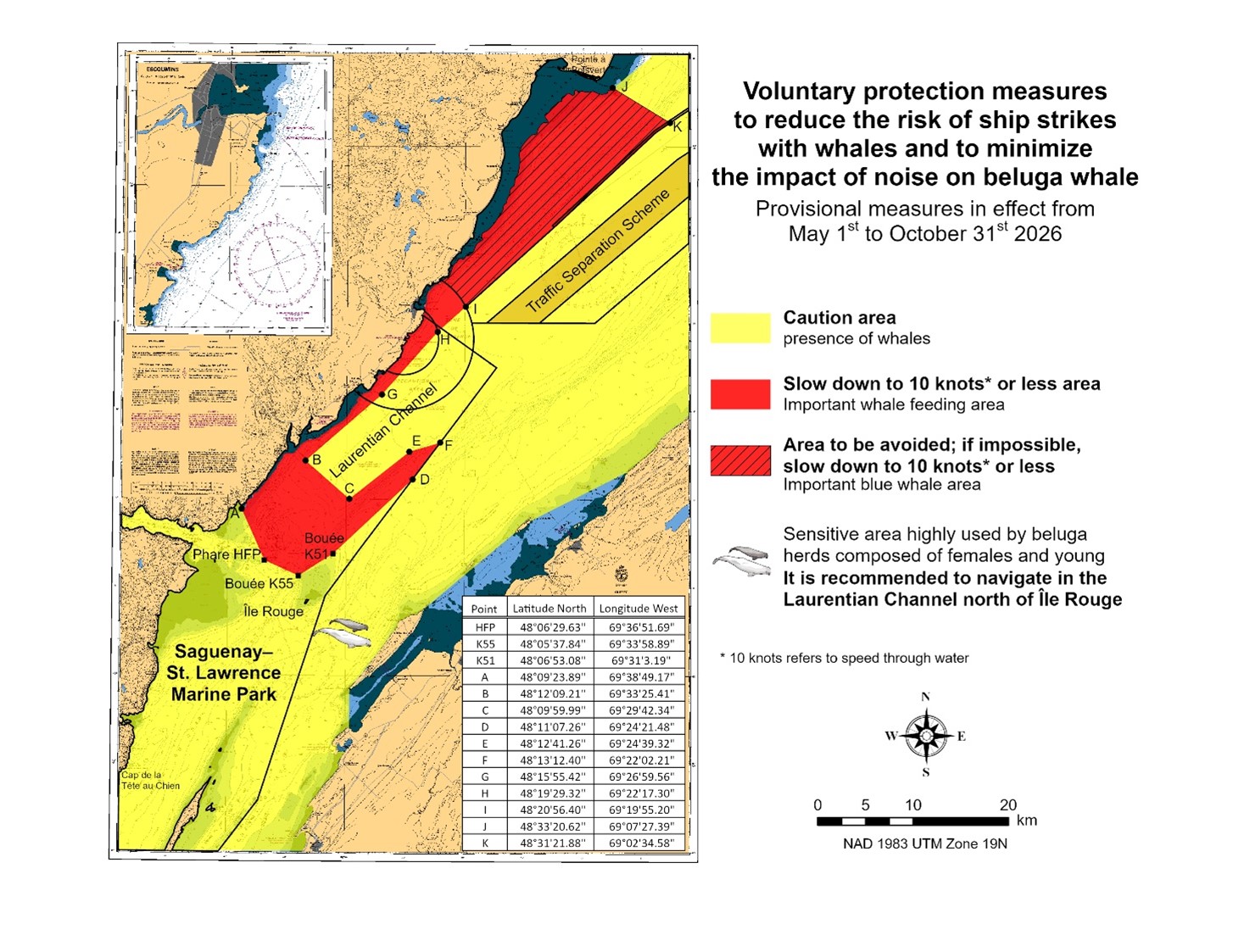
Voluntary protection measures
Provisional measures in effect from May 1 to October 31, 2026. See map at the end of this notice.
These measures apply to merchant vessels and cruise ships between Pointe à Boisvert and Cap de la Tête au Chien to prevent collisions with whales. These measures should only be taken when they will not jeopardize navigational safety.
Caution area (yellow area): To reduce the risk of collisions with whales that can be present anywhere in this area, heightened vigilance of navigators is critical. Posting a lookout is recommended in order to increase the chances of seeing the whales and thus taking necessary measures to avoid them. If bypassing the whales is not possible, slow down and wait for the animals to move away to a distance greater than 400 metres (0.215 nautical miles) before resuming original speed. It is more difficult to see the animals at night therefore increased caution is recommended.
Slow down to 10 knots or less area (red area): To reduce the risk of collisions with whales in this feeding area, it is recommended that vessels slow down to a maximum speed through the water of 10 knots and post a lookout. It is further recommended to remain in the Laurentian Channel to the north of Île Rouge to minimize the impact of noise in a sensitive area south of this island, which is highly frequented by herds of beluga whales composed of females and young.
Area to be avoided (hatched red area): To reduce noise and the risk of collisions with whales, vessels should avoid transiting through this area which is highly frequented by blue whales, an endangered species. If the area cannot be avoided, slow down to a speed through the water of 10 knots or less.
*801/26Canadian Hydrographic Service – Nautical Charts
|
New Charts |
|||
|
Charts |
Main Title |
Version Date |
Release Date |
|
3654 |
Bamfield Inlet and/et Grappler Inlet |
2026-07-10 |
2026-08-28 |
*802/26Canadian Hydrographic Service – Electronic Navigational Charts
|
New Products |
|||
|
S-57 & S-101 ENC Number |
Chart Title |
Usage |
Published |
|
101CA00P493N1232W (Edn 1.000) |
First Narrows |
PORT |
2026-08-14 |
|
CA279KDA (Edn 1.000) |
CA279KDA |
OVERVIEW |
2026-08-21 |
|
CA28GKDA (Edn 1.000) |
CA28GKDA |
OVERVIEW |
2026-08-21 |
|
CA2AW79A (Edn 1.000) |
CA2AW79A |
OVERVIEW |
2026-08-21 |
|
CA2AW8GA (Edn 1.000) |
CA2AW8GA |
OVERVIEW |
2026-08-21 |
|
CA479KDA (Edn 1.000) |
Approaches and community of Saniqiluaq |
TRANSIT |
2026-08-21 |
|
CA479KPA (Edn 1.000) |
Saniqiluaq to Umiujaq Passage |
TRANSIT |
2026-08-21 |
|
CA479L0A (Edn 1.000) |
Saniqiluaq to Umiujaq Passage |
TRANSIT |
2026-08-21 |
|
CA479LAA (Edn 1.000) |
CA479LAA |
TRANSIT |
2026-08-21 |
|
CA5586AA (Edn 1.000) |
First Narrows |
PORT |
2026-08-14 |
|
CA55CSFA (Edn 1.000) |
CA55CSFA |
PORT |
2026-08-01 |
|
CA56F4BA (Edn 1.000) |
Stephens Narrows |
PORT |
2026-08-21 |
|
New Editions |
|||
|
S-57 & S-101 ENC Number |
Chart Title |
Usage |
Published |
|
101CA00T460N0720W (Edn 9.000) |
101CA00T460N0720W |
TRANSIT |
2026-08-21 |
|
CA24UP1A (Edn 3.000) |
Overview4800N06800W |
OVERVIEW |
2026-07-31 |
|
CA448MTA (Edn 9.000) |
Transit4600N07200W |
TRANSIT |
2026-08-21 |
|
CA448Q8A (Edn 3.000) |
CA448Q8A |
TRANSIT |
2026-08-21 |
|
CA448R5A (Edn 3.000) |
CA448R5A |
TRANSIT |
2026-08-14 |
|
CA44UPXA (Edn 2.000) |
Transit4800N06500W |
TRANSIT |
2026-07-31 |
|
CA473519 (Edn 2.000) |
Toronto to/à Hamilton |
APPROACH |
2026-08-07 |
|
CA53SLPA (Edn 2.000) |
Port4450N07570W |
PORT |
2026-08-14 |
|
CA53TLPA (Edn 2.000) |
Port4460N07570W |
PORT |
2026-08-14 |
|
CA53TLQA (Edn 2.000) |
Port4460N07560W |
PORT |
2026-08-14 |
|
CA53ULQA (Edn 2.000) |
Port4470N07560W |
PORT |
2026-08-14 |
|
CA53ULRA (Edn 2.000) |
Port4470N07550W |
PORT |
2026-08-14 |
|
CA53ULSA (Edn 2.000) |
Port4470N07540W |
PORT |
2026-08-14 |
|
CA53VLSA (Edn 2.000) |
Port4480N07540W |
PORT |
2026-08-14 |
|
CA549RCA (Edn 3.000) |
CA549RCA |
PORT |
2026-08-14 |
|
S-57 & S-101 ENC Number |
Chart Title |
Withdrawal Date |
|
CA373353 |
Eskimo Harbour |
2026-08-21 |
|
CA570007 |
Porlier Pass |
2026-08-28 |
|
CA570153 |
Chemainus Bay |
2026-08-21 |
|
CA570154 |
Ladysmith Harbour |
2026-08-21 |
|
CA570156 |
Dodd Narrows to/à Flat Top Islands |
2026-08-21 |
|
CA570188 |
Telegraph Harbour and/et Preedy Harbour |
2026-08-21 |
|
CA570383 |
Nanaimo Harbour and/et Departure Bay |
2026-08-21 |
|
CA670732 |
Chemainus |
2026-08-21 |
|
CA670735 |
Duke Point |
2026-08-21 |
|
CA670737 |
Harmac West |
2026-08-28 |
|
CA670738 |
Harmac East |
2026-08-21 |
|
CA670739 |
Nanaimo |
2026-08-21 |
|
CA670761 |
Pacific biological Station |
2026-08-21 |
*803/26Canadian Hydrographic Service – Raster Digital Charts (BSB V3)
|
Charts Permanently Withdrawn |
||
|
Charts |
Main Title |
Withdrawal Date |
|
RM-3489 |
Fraser River/Fleuve Fraser, Pattullo Bridge to/à Crescent Island |
2026-08-07 |
|
RM-4450 |
Saint Paul Island |
2026-08-28 |
|
RM-4492 |
Cascumpec Bay |
2026-08-21 |
*804/26Transport Canada - Ship Safety Bulletins #11 and #12/2026
New and updated Ship Safety Bulletins have recently been posted on the Transport Canada website.
To view or download these bulletins, please click on the links below:
SSB#11/2026 – Reporting requirements for the Canadian Carbon Intensity Indicator
SSB#12/2026 – Fuel sampling points for Canadian vessels
Sign up for e-Bulletin to receive an e-mail notice each time a new Ship Safety Bulletin is published on our website.
Contact us at marinesafety-securitemaritime@tc.gc.ca or 1-855-859-3123 (Toll Free).
Reminder – Comment Period for Active Preliminary Notices
This is a reminder that the comment period is still open for the following active Preliminary notices:
|
Notice # |
Reference Chart # |
Aids Affected |
Intent of Notice |
|
Arctic Coast |
|||
|
7787 |
4590 |
Daybeacon to be Discontinued |
|
Please refer to the Notices to Mariners - Monthly Summary of Temporary and Preliminary Notices publication for details.
Newfoundland and Labrador Coast
Temporary Notices
No notices applicable for this edition.
Preliminary Notices
No notices applicable for this edition.
Atlantic Coast
Temporary Notices
*806(T)/26Port de Montréal – Shallow Depths Reported
Reference chart: 1310
Shallow depths reported at the following coordinates:
|
45° 39.597’N 073° 29.229’W: |
1.9 metres |
|
45° 39.489’N 073° 29.190’W: |
1.8 metres |
|
45° 36.662’N 073° 27.618’W: |
2.6 metres |
|
45° 32.426’N 073° 30.996’W: |
1.8 metres |
|
45° 31.634’N 073° 31.992’W: |
0.8 metres |
(NW-C-3254-26)
*807(T)/26Sorel-Tracy à/to Varennes – Marine Works: Wharf Construction
Reference chart: 1311
Construction operations taking place daily between 1030 UTC and 2300 UTC at the Contrecoeur wharf. Barges, work boats and safety boats on site. Turbidity curtains identified with yellow lighted buoys.
Yellow scientific moorings temporarily established at:
|
45° 48.930’N 073° 18.496’W |
|
45° 49.406’N 073° 17.899’W |
|
45° 49.457’N 073° 17.842’W |
Minimum wake and wide berth requested.
(NW-C-3362-26)
*808(T)/26Canal de la Rive Sud – Shallow Depth Confirmed
Reference chart: 1429, 1430
Shallower depths confirmed at the following coordinates:
|
45° 23.213’N 073° 52.336’W: |
0.2 metres |
|
45° 22.529’N 073° 51.463’W: |
0.7 metres |
|
45° 24.419’N 073° 48.443’W: |
0.4 metres |
|
45° 24.524’N 073° 42.559’W: |
0.3 metres |
(NW-C-3016-26)
*809(T)/26Havre de Gaspé – Marine Works : Repair
Reference chart: 4416
Repair work taking place at the Port of Gaspé launch ramp
during daylight hours. Yellow silt curtain on site.
Minimum wake requested.
(NW-C-3471-26)
Preliminary Notices
|
Comment
Submission |
Comments should be directed to the following: |
*810(P)/26Pugwash Harbour, Wallace Harbour, Amet Sound and Approaches / et les Approches – Unlit Buoys to be Discontinued
Reference chart: 4937
The Canadian Coast Guard proposes to permanently discontinue
58 unlit buoys with designator “PLAS1” near Wallace Harbour
in the vicinity of 45° 49’ 05.5”N
063° 29’ 40.1”W.
Initial publication date: Friday, August 28, 2026
Comment submission
deadline: Thursday, November 26, 2026
(G2026-069)
Inland Waters
Temporary Notices
*811/26Nipigon Bay and Approaches/et les approche – Shallow Depths Charted
Reference: Notice 1212(T)/24 is cancelled (Chart 2312).
The shallow depths have been charted on ENC CA44UGNA.
Preliminary Notices
No notices applicable for this edition.
Arctic Coast
Temporary Notices
No notices applicable for this edition.
Preliminary Notices
|
Comment
Submission |
Comments should be directed to the following:
Superintendent, |
*812(P)/26Approches à/Approaches to Chisasibi – Aids to Navigation to be Discontinued
Reference chart: 5720
The Canadian Coast Guard proposes to permanently discontinue the following aids to navigation:
|
Aid Name |
LL No. |
Position |
|
Anik Islands |
6447.69 |
53° 49’ 34.5”N 079° 17’ 46.6”W |
|
Boat Island front range |
6447.71 |
53° 52’ 01.2”N 079° 08’ 44.5”W |
|
Boat Island rear range |
6447.72 |
53° 52’ 15.7”N 079° 08’ 46.0”W |
|
Turning Island |
6447.74 |
53° 51’ 16.9”N 079° 13’ 20.2”W |
Initial publication date: Friday, August 28, 2026
Comment submission
deadline: Thursday, November 26, 2026
(A2026-026 to 028)
*813(P)/26Great Slave Lake / Grand lac des Esclaves, Western Portion / Partie ouest – Aid to Navigation to be Discontinued
Reference chart: 6730
The Canadian Coast Guard proposes to permanently discontinue the following aid to navigation:
|
Aid Name |
LL No. |
Position |
|
Îles du Goulet |
180 |
61° 34’ 30.1”N 113° 23’ 36.1”W |
Initial publication date: Friday, August 28, 2026
Comment submission
deadline: Thursday, November 26, 2026
(A2026-029)
*814(P)/26Bathurst Inlet - Northern Portion/Partie nord – Daybeacon to be Discontinued
Reference chart: 7791
The Canadian Coast Guard proposes to permanently discontinue the following aid to navigation:
|
Aid Name |
LL No. |
Position |
|
Gull Island |
4495 |
67° 20’ 35.2”N 107° 47’ 47.0”W |
Initial publication date: Friday, August 28, 2026
Comment submission
deadline: Thursday, November 26, 2026
(A2026-025)
SECTION 2 - CHART CORRECTIONS
1313 - Batiscan au/to Lac Saint-Pierre - New Edition - 08-MAR-2019 - NAD 1983
(See Chart 1, P1)
(See Chart 1, P1)
1313 - Port de Trois-Rivières - New Edition - 08-MAR-2019 - NAD 1983
(See Chart 1, P1)
(See Chart 1, P1)
1315 - Québec à/to Donnacona - New Edition - 24-MAY-2019 - NAD 1983
(See Chart 1, I10)
(See Chart 1, I10)
1316 - Port de Québec - New Edition - 03-APR-2020 - NAD 1983
(See Chart 1, I10)
(See Chart 1, I10)
(See Chart 1, I10)
1317 - Continuation A - New Edition - 03-APR-2020 - NAD 1983
(See Chart 1, I10)
(See Chart 1, I10)
1550 - Breckenridge à/to Maclarens Landing - Sheet/Feuille 2 - New Edition - 27-MAY-2011 - NAD 1983
1554 - Rapides-des-Joachims au/to Maraboo Lake - Sheet/Feuille 1 - New Edition - 16-JUN-2006 - NAD 1983
(See Chart 1, Qb)
(See Chart 1, Qc)
(See Chart 1, Qc)
1554 - Maraboo Lake à/to Bald Rock - Sheet/Feuille 2 - New Edition - 16-JUN-2006 - NAD 1983
(See Chart 1, Qb)
(See Chart 1, Qb)
(See Chart 1, Qb)
(See Chart 1, Qb)
(See Chart 1, Qb)
(See Chart 1, Qc)
(See Chart 1, Qb)
(See Chart 1, Qc)
1554 - Bald Rock au/to Lac la Cave - Sheet/Feuille 3 - New Edition - 16-JUN-2006 - NAD 1983
(See Chart 1, Qc)
(See Chart 1, Qb)
(See Chart 1, Qb)
(See Chart 1, Qb)
(See Chart 1, Qb)
(See Chart 1, Qc)
(See Chart 1, Qc)
(See Chart 1, Qc)
(See Chart 1, Qb)
2067 - Hamilton Harbour - New Edition - 02-NOV-2018 - World Geodetic System 1984
(See Chart 1, F14)
43°16′36.2″N 079°51′19.8″W
and 43°16′36.4″N 079°51′20.3″W
(See Chart 1, F14)
43°16′36.1″N 079°51′19.8″W
43°16′36.4″N 079°51′19.8″W
43°16′36.5″N 079°51′19.9″W
and 43°16′36.4″N 079°51′20.3″W
4023 - Northumberland Strait / Détroit de Northumberland - New Edition - 27-DEC-2002 - World Geodetic System 1984
(See Chart 1, Qd)
(See Chart 1, Qc)
(See Chart 1, Qc)
4243 - Tusket Islands to / à Cape St Marys - New Edition - 11-OCT-2002 - NAD 1983
(See Chart 1, R1)
4244 - Wedgeport and Vicinity / et les abords - New Edition - 26-DEC-2003 - NAD 1983
(See Chart 1, R1)
4266 - Sydney Harbour - New Edition - 28-FEB-2014 - NAD 1983
(See Chart 1, I10)
(See Chart 1, I10)
(See Chart 1, I10)
(See Chart 1, I10)
(See Chart 1, I10)
(See Chart 1, I10)
(See Chart 1, I10)
(See Chart 1, I10)
(See Chart 1, I10)
(See Chart 1, I10)
(See Chart 1, I10)
(See Chart 1, I10)
(See Chart 1, I10)
(See Chart 1, I10)
(See Chart 1, I10)
(See Chart 1, I10)
(See Chart 1, I10)
(See Chart 1, Qb)
to 46°14′15.8″N 060°11′50.6″W
(See Chart 1, Qb)
(See Chart 1, Qb)
(See Chart 1, Qb)
to 46°10′45.4″N 060°13′05.7″W
(See Chart 1, Qb)
(See Chart 1, Qb)
(See Chart 1, Qb)
(See Chart 1, Qb)
(See Chart 1, Qb)
(See Chart 1, Qc)
(See Chart 1, Qc)
(See Chart 1, Qc)
(See Chart 1, Qb)
(See Chart 1, Qg)
(See Chart 1, Qg)
(See Chart 1, Qb)
(See Chart 1, Qb)
(See Chart 1, Qc)
4266 - Sydney Wharves / Quais - New Edition - 28-FEB-2014 - NAD 1983
(See Chart 1, Qc)
(See Chart 1, Qb)
4266 - Sydport - New Edition - 28-FEB-2014 - NAD 1983
(See Chart 1, Qb)
4276 - Little Bras D'Or A-B - New Edition - 24-FEB-2017 - NAD 1983
(See Chart 1, Q7, Qf)
(See Chart 1, Q7)
4367 - Flint Island to / à Cape Smokey - New Edition - 03-APR-2003 - NAD 1983
(See Chart 1, I10)
(See Chart 1, I10)
4425 - St. Peters Bay - New Edition - 01-NOV-2002 - NAD 1983
(See Chart 1, P1)
4486 - Baie des Chaleurs / Chaleur Bay - New Edition - 19-FEB-1999 - NAD 1983
(See Chart 1, Qd)
(See Chart 1, Qd)
4615 - Harbours in Placentia Bay / Havres dans Placentia Bay: Petit forte to / à Broad Cove Head - New Edition - 20-AUG-1999 - NAD 1983
(See Chart 1, Qb)
to 47°21′30.6″N 054°53′17.1″W
4722 - Terrington Basin - New Edition - 25-OCT-2013 - NAD 1983
(See Chart 1, Qc)
to 53°21′01.4″N 060°21′00.7″W
(See Chart 1, Qb)
to 53°21′02.6″N 060°21′07.6″W
(See Chart 1, Qc)
to 53°20′59.7″N 060°21′14.0″W
(See Chart 1, Qb)
to 53°20′58.8″N 060°21′33.4″W
(See Chart 1, Qc)
to 53°20′57.5″N 060°21′31.3″W
4906 - West Point à / to Baie de Tracadie - New Chart - 18-MAR-1988 - NAD 1983
(See Chart 1, Qd)
(See Chart 1, Qc)
(See Chart 1, Qc)
4909 - Richibucto Harbour - New Chart - 17-JUN-1988 - NAD 1983
(See Chart 1, Qd)
4911 - Entrée à / Entrance to Miramichi River - New Edition - 27-JAN-2006 - NAD 1983
(See Chart 1, Qc)
(See Chart 1, Qc)
4913 - Caraquet Harbour, Baie de Shippegan and / et Miscou Harbour - New Chart - 07-AUG-1992 - NAD 1983
(See Chart 1, Qd)
(See Chart 1, Qd)
(See Chart 1, P1)
(See Chart 1, P1)
4920 - Middle Caraquet - New Edition - 14-DEC-2018 - NAD 1983
(See Chart 1, P1)
(See Chart 1, P1)
(See Chart 1, P16)
4920 - Shippegan Harbour - New Edition - 14-DEC-2018 - NAD 1983
(See Chart 1, Qd)
(See Chart 1, Qd)
4935 - Murray Harbour to/à Boughton Bay - New Chart - 18-JAN-2019 - NAD 1983
(See Chart 1, Qc)
to 46°13′56.2″N 062°36′25.7″W
(See Chart 1, Qc)
4958 - Cap-aux-Meules et/and Havre-aux-Maisons - New Chart - 01-NOV-2024 - World Geodetic System 1984
(See Chart 1, Qb)
5001 - Labrador Sea / Mer du Labrador - New Edition - 17-JAN-2003 - NAD 1983
(See Chart 1, I10)
5628 - Rankin Inlet Including / Y Compris Melvin Bay And/ Et Prairie Bay - New Chart - 08-AUG-1997 - NAD 1983
(See Chart 1, L41.1)
and 62°47′49.2″N 092°06′10.1″W
5629 - Marble Island to/à Rankin Inlet - New Chart - 27-OCT-2000 - NAD 1983
(See Chart 1, L41.1)
and 62°47′49.2″N 092°06′10.1″W
6258 - Montreal Point to/à Kettle Island - Sheet/Feuille 1 - New Chart - 30-DEC-1988 - NAD 1983
(See Chart 1, Qb)
to 53°43′39.9″N 097°51′57.6″W
6259 - Kettle Island to/à Martin Point - Sheet/Feuille 1 - New Chart - 23-FEB-1990 - NAD 1983
(See Chart 1, Qb)
to 53°50′03.2″N 097°59′27.1″W
SECTION 3 - RADIO AIDS TO MARINE NAVIGATION CORRECTIONS
*815/26Radio Aids to Marine Navigation 2026 (Atlantic, St. Lawrence, Great Lakes, Lake Winnipeg, Arctic and Pacific)
AMEND AS FOLLOWS:
4.3.13Marine Telephone Service
4.3.13.1 General
This service enables a person aboard a ship to speak directly
to any person ashore, or vice versa. The service is an
extension of the public telephone system to ships at sea
through MCTS Centres. Long distance
ship-to-shore calls may only be made as collect calls or
charged to a telephone company calling card/pre-paid card.
Refer to
Part 2 of this publication to find MCTS Centres that
provide the marine telephone call service.
4.3.13.2 Placing a Marine Telephone Call
Ship to Shore
a)Listen to
make sure that the MCTS Centre is not busy with another
ship.
b)Call the
MCTS Centre and when communication has been established give
the following:
i.name of the city being called;
ii.name and/or telephone number of the person being
called;
iii.name of the caller or the
number of the caller’s telephone company credit calling card
(if applicable).
c)When the call is completed, sign off, using the name and call sign of the ship.
Shore to Ship
a)Dial the appropriate MCTS Centre.
b)Give the MCTS Officer the name of the person and ship being called.
Receiving a Marine Telephone Call
a)When you hear your ship being called, reply, giving your ship’s name and call sign.
b)At the end of the conversation, sign off by announcing the name and call sign of your vessel.
SECTION 4 - CANADIAN SAILING DIRECTIONS CORRECTIONS
The following Canadian Sailing Directions volumes have recently been updated on the Canadian Hydrographic Service website.
|
No. |
Title |
|
Atlantic Coast |
|
|
ATL 103 |
Newfoundland, Southwest Coast |
|
ATL 111 |
St. Lawrence River, Île Verte to Québec and Fjord du Saguenay |
|
Pacific Coast |
|
|
PAC 203 |
Cape Caution to Stewart and Haida Gwaii |
Each volume includes a section entitled “Record of Changes” which lists all updates that are incorporated during the current calendar year.
SECTION 5 - LIST OF LIGHTS, BUOYS AND FOG SIGNALS CORRECTIONS
The amendments are highlighted and deletions are crossed out. For general and region-specific
information on the List of Lights, click on the following links:
Newfoundland and Labrador Coast,
Atlantic Coast,
Inland Waters and
Pacific Coast.
Newfoundland and Labrador Coast
| No. ----- Intl No. |
Name ----- RACON |
Location ----- Latitude N. Longitude W. |
Light Characteristics |
Focal Height Above Water (m) |
Nominal Range (NM) |
Description ----- Height of Structure Above Ground Level (m) |
Remarks ----- Audible Signals ----- AIS |
|||
|---|---|---|---|---|---|---|---|---|---|---|
| STRAIT OF BELLE ISLE (LL 211 - 234) | ||||||||||
| 221.31 H0149 |
Bartletts Harbour Wharf Light |
50 56 28.5 056 59 29.2 |
Fl |
G |
4s |
3.5 |
3 |
Mast. |
Seasonal. |
|
Atlantic Coast
| No. ----- Intl No. |
Name ----- RACON |
Location ----- Latitude N. Longitude W. |
Light Characteristics |
Focal Height Above Water (m) |
Nominal Range (NM) |
Description ----- Height of Structure Above Ground Level (m) |
Remarks ----- Audible Signals ----- AIS |
|||
|---|---|---|---|---|---|---|---|---|---|---|
| PRINCE EDWARD ISLAND (LL 942 - 1084.7) | ||||||||||
| 1055 H1140 |
Rustico Harbour Northern Breakwater |
On outer end of N. breakwater. 46 27 25.2 063 17 16.9 |
Fl |
R |
5s |
2.8 |
4 |
Cylindrical mast, red and white triangular daymark. |
Seasonal. Flash 1 s; eclipse 4 s. |
|
| NORTHUMBERLAND STRAIT - WEST (LL 1085 - 1165.9) | ||||||||||
| 1142 H1394 |
North Richibucto Beach Inner front range light |
On shore behind breakwater. 46 42 57.5 064 47 58.9 |
F |
W |
..... |
8.1 |
8 |
Square skeleton tower, red and white rectangular daymark. |
Seasonal. |
|
| 1145 H1400 |
South Richibucto Beach Inner front range light |
On W. end of the beach. 46 42 29.5 064 48 02.0 |
F |
R |
..... |
7.7 |
8 |
Square skeleton tower, red daymark with white vertical stripe. |
Seasonal. |
|
| 1146 H1400.1 |
South Richibucto Beach Inner rear range light |
46 42 33.5 064 47 49.3 065°44' 296.3 m from front. |
Oc |
R |
10s |
11.3 |
8 |
Square skeleton tower, red daymark with white vertical stripe. |
Seasonal. Flash 7 s; eclipse 3 s. |
|
| 1157 |
Kouchibouguac Gully light buoy XY2 |
46 49 58.0 064 53 53.3 |
Fl |
R |
4s |
..... |
..... |
Red, spar, marked “XY2”. |
Seasonal. Buoy may be repositioned due to shifting channel. |
|
| 1157.33 |
Kouchibouguac light buoy XY4 |
46 49 57.5 064 54 02.9 |
Fl |
R |
4s |
..... |
..... |
Red, pillar, marked “XY4”. |
Seasonal. Buoy may be repositioned due to shifting channel. |
|
| 1158.6 |
Kouchibouguac Gully light buoy XY17 |
46 49 59.6 064 54 42.1 |
Fl |
G |
4s |
..... |
..... |
Green, pillar, marked “XY17”. |
Seasonal. Buoy may be repositioned due to shifting channel. |
|
Inland Waters
| No. ----- Intl No. |
Name ----- RACON |
Location ----- Latitude N. Longitude W. |
Light Characteristics |
Focal Height Above Water (m) |
Nominal Range (NM) |
Description ----- Height of Structure Above Ground Level (m) |
Remarks ----- Audible Signals ----- AIS |
|||
|---|---|---|---|---|---|---|---|---|---|---|
| ST. LAWRENCE SEAWAY, CANAL DE BEAUHARNOIS TO KINGSTON (LL 33 - 401) | ||||||||||
| 131 H2558.1 |
Cameron Island Lower rear range light |
45 04 14.8 074 30 29.7 207°15' 696.2 m from front. |
F |
G |
..... |
18.0 |
13 |
Skeleton tower, red triangular daymark with black vertical stripe. |
Seasonal. Operates 24 h. |
|
| 146 H2574 |
Clark Island Light D70 |
At E. end of island. 45 02 52.5 074 33 57.9 |
Fl |
R |
4s |
8.7 |
..... |
Square mast, white rectangular daymark with red top, marked “D70”. |
Seasonal. |
|
| LAKE ONTARIO (LL 403.4 - 551) | ||||||||||
| 448.9 |
Shermans Point light buoy Q8 |
SW. of point. 44 06 01.2 077 04 10.0 |
Fl |
R |
4s |
..... |
..... |
Red, spar, marked “Q8”. |
Seasonal (in place year round). |
|
| 479 |
Trent River Entrance |
44 05 44.6 077 33 55.3 |
Fl |
G |
4s |
..... |
..... |
Green, spar, marked “Q75”. |
Seasonal (in place year round). |
|
| LAKE SUPERIOR (LL 1082 - 1161) | ||||||||||
| 1092.5 |
Michipicoten River Entrance |
On rock. 47 55 59.6 084 51 06.8 |
Iso |
Y |
4s |
6.1 |
7 |
Cylindrical mast, cylindrical white daymark. |
Seasonal. |
|
| LAKE WINNIPEG (LL 1563.1 - 1625) | ||||||||||
| 1596.2 |
Egg Islands light buoy DX3 |
S. of island. 51 52 38.5 097 06 36.1 |
Fl |
G |
4s |
..... |
..... |
Green, spar, marked “DX3”. |
Seasonal. |
|
Report a problem on this page
- Date modified: