

Notices to Mariners
June 28, 2024

Safety First, Service Always
Monthly Eastern Edition
CONTENTS
| Section 1 | General and Safety Information |
| Section 1A | Temporary and Preliminary Notices |
| Section 2 | Chart Corrections |
| Section 3 | Radio Aids to Marine Navigation Corrections |
| Section 4 | Canadian Sailing Directions Corrections |
| Section 5 | List of Lights, Buoys and Fog Signals Corrections |
Notices to Mariners – Monthly Eastern Edition
Edition No. 06/2024
Aussi disponible en français :
Avis aux navigateurs – Édition mensuelle de l’Est
Édition n° 06/2024
Published under the Authority of:
Canadian Coast Guard Programs
Aids to Navigation and Waterways
Fisheries and Oceans Canada
Montreal, QC H2Y 2E7
For more information, contact Notmar.XNCR@dfo-mpo.gc.ca.
© His Majesty the King in Right of Canada,
as represented by the Minister of Fisheries, Oceans
and the Canadian Coast Guard, 2024.
Cat. No. Fs152-8E-PDF (Electronic PDF, English)
ISSN 2817-0075
Cat. No. Fs152-8F-PDF (Electronic PDF, French)
ISSN 2817-0083

Explanatory Notes – Notices to Mariners (NOTMAR)
Geographical positions refer directly to the graduations of the largest scale Canadian Hydrographic Service chart (unless otherwise indicated).
Bearings refer to the true compass and are measured clockwise from 000° (North) clockwise to 359°; those relating to lights are from seaward.
Visibility of lights is that in clear weather.
Depths - The units used for soundings (metres, fathoms or feet) are stated in the title of each chart.
Elevations are normally given above Higher High Water, Large Tide (unless otherwise indicated).
Distances may be calculated as follows:
1 nautical mile = 1,852 metres (6,076.1 feet)
1 statute mile = 1,609.3 metres (5,280 feet)
1 metre = 3.28 feet
Temporary and Preliminary Notices to Mariners – Section 1A of Notices to Mariners
These notices are indicated by a (T) or a (P), respectively. Please note that nautical charts are not amended by the Canadian Hydrographic Service for temporary (T) and preliminary (P) notices. It is recommended that mariners chart these corrections in pencil. For the list of charts affected by (T) & (P) notices, please refer to the current Notices to Mariners - Monthly Summary of Temporary and Preliminary Notices publication.
Suggestions and Corrections Form
This form is specifically for suggestions and corrections to Notices to Mariners publications. It is available online and also in fillable PDF format included with the monthly publication ZIP file.
To submit comments and suggestions on possible improvements to the various publications and services: Notmar.XNCR@dfo-mpo.gc.ca.
To report chart discrepancies and/or corrections to the Canadian Sailing Directions booklets: Fill out the Marine Information Reporting Form and/or email chsinfo@dfo-mpo.gc.ca.
To report emergencies or navigational hazards: Contact your nearest MCTS centre
- VHF channel 16 (156.8 MHz)
- MF/HF frequency 2182 kHz/4125 kHz (where available)
- ∗16 on a cellphone (where available)
NOTMAR Website – Monthly Editions, Chart Corrections and Chart Patches
The NOTMAR website allows users to access the monthly publications,
chart corrections, and chart patches.
Users can subscribe for free to the email notification service
to receive notifications when charts of interest are updated, including their patches, as well as when a new Monthly Edition of Notices to Mariners is published.
In addition, the monthly publication and related
files to download, such as chart patches, can be obtained
all together through the download of a single ZIP file.
Explanatory Notes – Canadian Hydrographic Service (CHS)
Chart Corrections – Section 2 of Notices to Mariners
Corrections to nautical charts will be listed in numerical order by chart number. Each chart correction listed applies only to that particular chart. Related charts, if any, will have their own specific correction listed separately.
Users should also refer to CHS Chart 1: Symbols, Abbreviations and Terms for additional information pertaining to the correction of charts.
The illustration below describes the elements that will comprise a typical Section 2 chart correction:

The last correction number is identified with the LNM/D or Last Notice to Mariners Number / Date.
Mariners are advised that only the most critical changes that directly affect safety to navigation are issued in “Section 2 – Chart Corrections.” This limitation is required to ensure that charts remain as clear and easy to read as possible. As a result, mariners may see minor discrepancies of a non-critical nature between information in official publications. For example, a small change in the nominal range or focal height of a light may not result in the production of a chart correction in Notices to Mariners, but may result in a correction in the List of Lights, Buoys and Fog Signals publication.
Note: In the case of a discrepancy between information provided on CHS charts relating to aids to navigation, and the List of Lights, Buoys and Fog Signals publication, the latter shall be deemed as containing the most up-to-date information.
Canadian Nautical Charts & Publications
A source list of Canadian nautical charts and publications is published in Notice No. 14 of the Notices to Mariners Annual Edition 2024. The source supply and the prices effective at the time of printing are listed. For current chart edition dates, please refer to the following website: www.chs-shc.gc.ca/charts-cartes/paper-papier/index-eng.asp
Explanatory Notes – Marine Communications and Traffic Services (MCTS)
Navigational Warnings / Notices to Shipping
The Canadian Coast Guard (CCG) is implementing a number of changes to the aids to navigation system in Canada.
These changes are advertised as Navigational Warnings, formerly called Notices to ShippingFootnote 1, that are broadcast by the CCG, and are then followed up with Notices to Mariners, then charts are updated by hand correction, reprints or new editions.
Mariners are advised that all relevant Navigational Warnings (NAVWARN) should be kept until superseded by Notices to Mariners or through revised charts issued by the Canadian Hydrographic Service (CHS).
NAVWARN are accessible on the applicable regional page on the CCG Navigational Warnings website at http://nis.ccg-gcc.gc.ca.
CHS is reviewing the impact of these changes with CCG and together are preparing an action plan on the issuing of chart revisions.
For further information, contact your regional NAVWARN Issuing Desk.
Atlantic Region (North)
* Port aux Basques MCTS Centre
“N” Series NAVWARN
Canadian Coast Guard
49 Stadium Rd.
P.O. Box 99
Port aux Basques, NL A0M 1C0
Telephone: 709-695-2168 or 1-800-563-9089
Facsimile: 709-695-7784
Email: NAVWARN.MCTSPortAuxBasques@innav.gc.ca
Central Region
* Prescott MCTS Centre
“Q” and “C” Series NAVWARN
Canadian Coast Guard
401 King Street West
P.O. Box 1000
Prescott, ON K0E 1T0
Telephone: 613-925-0666
Facsimile: 613-925-4519
Email: NAVWARN.MCTSPrescott@innav.gc.ca
Atlantic Region (South)
* Sydney MCTS Centre
“M” Series NAVWARN
Canadian Coast Guard
1190 Westmount Road
Sydney, NS B1R 2J6
Telephone: 902-564-7751 or 1-800-686-8676
Facsimile: 902-564-7662
Email: NAVWARN.MCTSSydney@innav.gc.ca
Arctic Region
* Iqaluit MCTS Centre
Operational from approximately mid-May until late December.
“A” Series NAVWARN
Canadian Coast Guard
P.O. Box 189
Iqaluit, NU X0A 0H0
Telephone: 867-979-5269
Facsimile: 867-979-4264
Email: NAVWARN.MCTSIqaluit@innav.gc.ca
* Service available in English and French.
Index
Numerical Index of Canadian Charts Affected
This numerical index lists all nautical charts mentioned in this monthly edition of Notices to Mariners. Only charts appearing in Section 2 of this publication require a chart correction. The appearance of charts in all other sections, particularly those related to the correction of other nautical publications, is included here for reference.
| 1230 | 2326 | 4483 | 4853 |
| 1234 | 3811 | 4486 | 4855 |
| 1236 | 4003 | 4521 | 4885 |
| 1310 | 4012 | 4522 | 4909 |
| 1312 | 4013 | 4523 | 4912 |
| 1313 | 4022 | 4530 | 4920 |
| 1320 | 4024 | 4538 | 4921 |
| 1512 | 4116 | 4585 | 4934 |
| 1515 | 4141 | 4617 | 4935 |
| 1552 | 4227 | 4639 | 4967 |
| 2044 | 4233 | 4642 | 4969 |
| 2050 | 4236 | 4659 | 5052 |
| 2202 | 4237 | 4667 | 6035 |
| 2224 | 4266 | 4679 | 6100 |
| 2235 | 4320 | 4821 | 6432 |
| 2241 | 4321 | 4825 | 7664 |
| 2251 | 4376 | 4831 | 8007 |
| 2273 | 4381 | 4841 | |
| 2297 | 4386 | 4850 | |
| 2314 | 4425 | 4851 |
SECTION 1 - GENERAL AND SAFETY INFORMATION
*505/23Canadian Hydrographic Service – Magnetic Declination Calculations
(Recurrent publication of notice *505/23, originally published in the Notices to Mariners – Monthly Eastern Edition 05/2023 publication.)
Mariners are advised that CHS has adopted the harmonized World Magnetic Model (WMM), as found on the NCEI/NOAA website. Old compass rose declination information on CHS navigational products can be updated using this website: https://www.ngdc.noaa.gov/geomag/calculators/magcalc.shtml#declination. While the differences in the model declinations are small each year, they can become more significant over a large period of time.
*1207/23Canadian Hydrographic Service – Inappropriate Geographical Names Review Process
(Recurrent publication of notice *1207/23, originally published in the Notices to Mariners – Monthly Eastern Edition 12/2023 publication.)
The records of the Canadian Hydrographic Service could contain geographical names that may be considered inappropriate, offensive and derogatory. Geographical naming authorities are in the process of addressing many offensive place names, the review process is underway. For more information, about inappropriate geographical names, please see the following announcement.
*401/24Protecting the North Atlantic Right Whale: Speed Restriction Measures in the Gulf of St. Lawrence
(Recurrent publication of notice *401/24, originally published in the Notices to Mariners – Monthly Eastern Edition 04/2024 publication.)
Purpose
This bulletin describes the speed restriction zones that vessels
must follow in the Gulf of St. Lawrence.
The Government of Canada has established these zones to reduce
the risk of vessel colliding with North Atlantic right whales
(NARW).
Background
Due to changing migration patterns of North Atlantic right whales and their increased presence in the Gulf of St. Lawrence, the Government of Canada has set seasonal speed restrictions in specific zones. These speed restrictions zones are defined as “static zones”, “dynamic shipping zones”, “seasonal management areas”, a “voluntary seasonal slowdown zone’’ and a “restricted area”. See the map below for details.
Note: Vessels must follow Navigational Warnings outlining the speed restrictions. The Interim Order for the Protection of North Atlantic Right Whales (Eubalaena Glacialis) in the Gulf of St. Lawrence, 2024 enables the issuance of Navigational Warnings (NAVWARNs) imposing speed restrictions and navigation restrictions.
Speed restriction zones are described in monthly Notices to Mariners (NOTMARs), which are published by the Canadian Coast Guard. The status of these zones is broadcasted through NAVWARNs, which are published by the Coast Guard’s Marine Communications and Traffic Services Centres.
Changes to speed restriction zones and measures
Based on consultations with industry and on scientific data,
changes to the speed restriction zones will be effective from
April 17th, 2024, while the restricted area will be implemented
based on whale presence.
A voluntary seasonal slowdown of 10.0 knots over the ground
spanning from Cabot Strait (a line running from Cape North NS
to Cape Ray NL) to the eastern edge of dynamic shipping zone E
will be implemented at the beginning and end of the North
Atlantic right whale season (Spring and fall).
Please check the latest NAVWARN for all speed restrictions
currently in effect.
Speed Restriction Measures for 2024
These restrictions will be in effect from April 17 to November 15, 2024.
Exceptions
The following exception will apply to all measures:
a)a vessel in distress or providing assistance to a
person or a vessel in distress;
b)a government vessel being used
i.for law enforcement activities;
ii.for search and rescue operations; or
iii.to ensure the competency of the crew or the operational readiness of the vessel or crew with respect to such activities or operations.
Static zones
In the static zones, all vessels above 13 m in length overall (LOA) must proceed at a speed of not more than 10.0 knots over the ground.
Exclusions
Air cushion vessels operated by or on behalf of the Government of Canada that are engaged in ice-clearing activities from April to June in and around Chaleur Bay are exempted when in operation.
36.57 m (20-fathom) shallow water protocol exclusion
Vessels engaged in any commercial fishing activity may proceed at a safe operational speed in waters not more than 36.57 m (20 fathom) deep within the static zones.
If a notice to fish harvesters and a NAVWARN state that at least one North Atlantic right whale has been detected in waters within a static zone or its associated buffer zone that are not more than 36.57m deep, the speed limit of 10.0 knot over the ground will apply in the concerned zone(s) to all vessels above 13m in length overall (LOA). The speed restriction will be in effect for 15 days after the day on which the whale was detected. The buffer zones associated with the static zones are located 5 miles north and south of their adjacent border in waters less than 36.57m deep.
|
Coordinates for the northern static zone:
•50° 20’ N 065° 00’ W |
Coordinates for the southern static zone:
•48° 40’ N 065° 00’ W |
Dynamic shipping zones
There are five dynamic shipping zones (DSZ) located in the routeing systems north and south of Anticosti Island: A, B, C, D and E
Coordinates for the dynamic shipping zones:
|
Zone A
•49⁰ 41’ N, 065⁰ 00’ W |
Zone B
•49⁰ 22’ N, 064⁰ 00’ W |
Zone C
•49⁰ 00’ N, 063⁰ 00’ W |
|
Zone D
•50⁰ 16’ N, 064⁰ 00’ W |
Zone E
•48⁰ 35’ N 062⁰ 00’ W |
|
When a North Atlantic right whale is detected in a dynamic shipping zone or in the buffer zones, located 5 nautical miles south or 2.5 nautical miles from the eastern and western edges of the dynamic shipping zones:
•All vessels will be notified via a NAVWARN; and
•Vessels above 13 m in length overall (LOA) must proceed at a speed of not more than 10.0 knots over the ground within that zone.
Even though dynamic shipping zones overlap with static zones, vessels can travel at a safe operational speed in dynamic shipping zones when they are not under speed restriction. Mariners must also keep in mind that North Atlantic right whales may be nearby.
Speed restrictions in the dynamic shipping zones
The detection of North Atlantic right whales in one or more dynamic shipping zone(s), or in their buffer zones, will trigger a speed restriction in the concerned zone(s). The speed restriction in the dynamic shipping zone(s) will be in effect for 15 days from the date of detection. In the event of a new North Atlantic right whale detection occurring in the last 7 days of the 15-day slowdown period, the speed restriction will be extended for an additional 15 days from the date of the new detection. This would continue until no NARW are detected.
When a NAVWARN is issued implementing a speed restriction in one or more dynamic shipping zone(s), vessels above 13 m in length (LOA) must not exceed a speed of 10.0 knots over the ground. Within any dynamic zone that is not subject to a speed restriction, mariners may proceed at a safe operational speed. Mariners are encouraged to take into consideration the potential for their vessel striking North Atlantic right whales when considering a “safe operational speed” during navigation.
Seasonal management areas
Seasonal management area 1 (SMA-1) and seasonal management area 2 (SMA-2) are speed restriction areas located north and south of dynamic shipping zone E, respectively.
Within seasonal management areas, vessels above 13 m in length (LOA):
•must restrict their speed so as not to exceed 10.0 knots over the ground from April 17th to June 25th, 2024; and
•are allowed to proceed at a safe operational speed from June 26th to November 15th, 2024, unless a North Atlantic right whale is detected. If a whale is detected, a speed restriction of 10.0 knots over the ground will be triggered for 15 days from the date of detection. In the event of a new North Atlantic right whale detection occurring in the last 7 days of the 15-day slowdown period, the speed restriction will be extended for an additional 15 days from the date of the new detection. This would continue until no North Atlantic right whales are detected.
|
Coordinates for the SMA-1:
•49° 04’ N 062° 00’ W |
Coordinates for the SMA-2:
•48° 24’ N 062° 00’ W |
Restricted area
In the summer months, an important proportion of the total North Atlantic right whale population gathers for feeding and surface activity near the Shediac Valley. Since this makes the North Atlantic right whale more susceptible to vessel collisions, a mandatory restricted area will be implemented in and near the Shediac Valley and will come into force once 80% of the restricted area is closed to fishing for the season as per the Department of Fisheries and Oceans’ right whale closure protocol or at the latest on June 19th, 2024. The restricted area will be lifted once the North Atlantic right whale detections decrease in the restricted area or at the latest on September 25th, 2024.
The size and location of the area are determined based on historical detection data of North Atlantic right whales. All necessary details can be found in the Interim Order for the Protection of North Atlantic Right Whales (Eubalaena Glacialis) in the Gulf of St. Lawrence, 2024. Triggering and lifting of the restricted area will be communicated to mariners through NAVWARNs and notices to fish harvesters.
Vessels above 13 m in length (LOA) will be required to:
•avoid the area unless they are part of the exceptions listed in the Interim Order for the Protection of North Atlantic Right Whales (Eubalaena Glacialis) in the Gulf of St. Lawrence, 2024;
•transit the area at a speed not exceeding 8.0 knots over the ground if they are part of the exceptions.
The following exceptions will apply to the restricted area. The following listed vessels can travel through the area at not more than 8.0 knots over the ground:
•A vessel being used for commercial fishing;
•A vessel being used for fishing under the authority of
a licence issued under the Aboriginal Communal Fishing
Licences Regulations;
•A vessel being used for research purposes on behalf of
the Government of Canada
•A vessel being used as part of the Department of
Fisheries and Oceans’ Marine Mammal Response Program to assist
a marine mammal or sea turtle in distress or to access or
retrieve a deceased marine mammal or sea turtle;
•A vessel authorized by the Government of Canada to
retrieve or identify the location of abandoned or lost fishing
gear;
•A vessel involved in pollution response
operations;
•A vessel avoiding immediate or unforeseen danger;
•A vessel involved in research relating to right whales as part of a project that has received funding from the Government of Canada.
The following vessels can travel through the restricted area at a speed over 8.0 knots, but below 10.0 knots over the ground as required by the static speed restriction zone:
•A vessel being used by an employee of the Government of Canada or peace officer who is performing their duties.
Coordinates for the restricted area:
•48°31.8’ N 063°39.6’ W
•48°24.72’ N 063°17.88’ W
•47°18.84’ N 064°10.8’ W
•47°27.18’ N 064°30.72’ W
Inclement weather exception
Mariners will be notified in advance via a NAVWARN should the speed restriction status change in any zone or area, due to inclement weather.
Within any zone or area that is no longer subject to a speed restriction due to adverse weather conditions, mariners may proceed at a safe operational speed. Mariners are however encouraged to take into consideration the potential for their vessel striking North Atlantic right whales when considering a “safe operational speed” during navigation.
*Non-excepted vessels are still prohibited from transiting through the restricted area.
Voluntary seasonal slowdown in Cabot Strait
To coincide with the North Atlantic right whales entering and exiting the Gulf of St. Lawrence in large numbers, a voluntary seasonal slowdown is being put in place in Cabot Strait from April 17th to June 25th, 2024, and from September 25th to November 15th, 2024.
•During these periods, vessels above 13 m in length (LOA) are requested to voluntarily reduce their speed as to not exceed 10.0 knots over the ground.
Voluntary seasonal slowdown zone coordinates:
•48° 10.5’ N 061° 00’ W
•47° 37.2’ N 059° 18.5’ W
•47° 02’ N 060° 23.7’ W
•47° 58.1’ N 061° 03.5’ W
•48° 00’ N 061° 00’ W
Map of the Gulf of St. Lawrence
The following map shows
•the static zones (north and south), in pink;
•the dynamic shipping zones (A, B, C, D and E), in
green;
•the seasonal management areas, in dark pink;
•the voluntary seasonal slowdown zone, in grey;
•the restricted area, in dark blue; and
•the 36.57 m (20 fathom) shallow water protocol line.
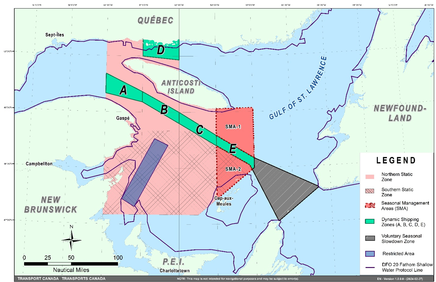
This map is for visual representation only and is not to be used for navigation or enforcement.
Roseway Basin – Area to be Avoided
The Roseway Basin, located approximately 20 nautical miles south of Cape Sable Island, Nova Scotia, is a critical habitat for North Atlantic right whales, which have been observed to gather in the area on a seasonal basis in Canadian waters. This critical habitat is also located near key shipping routes. In 2007, Canada, with the support of many groups with varied interests, proposed to the International Maritime Organization (IMO) the establishment of a seasonal Area to be Avoided in the Roseway Basin to protect North Atlantic right whales, which IMO accepted and adopted.
To reduce the risk of vessels colliding with North Atlantic right whales, it is recommended that vessels of 300 gross tonnages and more, in transit during the period of June 1 through December 31, avoid the Roseway Basin area. Smaller vessels are also encouraged to avoid passage through this area. If passage is necessary within the Area to be Avoided, it is recommended that all mariners decrease their vessel speed to no more than 10 knots, when safe to do so.
Roseway Basin coordinates:
•43° 16’ N 064° 55’ W
•42° 47’ N 064° 59’ W
•42° 39’ N 065° 31’ W
•42° 52’ N 066° 05’ W
NAVWARN broadcasts
The Canadian Coast Guard issues NAVWARNs:
•by radio broadcast; and
•online at Canada’s Maritime Information Portal and its Navigational Warnings site.
Mariners must ensure they have accurate and up-to-date information about the protection of the North Atlantic right whale, as in all applicable NOTMARs and NAVWARNs.
For the North Atlantic right whale speed restrictions, the NAVWARN(s) currently in effect will be provided to vessels subject to the Vessel Traffic Services Zone Regulations or the Eastern Canada Vessel Traffic Services Zone Regulations:
Outbound vessels will receive NAVWARNs
•at Calling-in-Point 10 (St-Laurent); or
•upon a departure downstream from the Quebec pilot station (including the Saguenay River, Chaleur Bay, Miramichi Bay, etc.)
Inbound vessels will receive NAVWARNs
•when a clearance to enter Canadian waters is granted
Vessels in transit will receive NAVWARNs
•at the last reporting point prior to entering the mandatory speed restriction zones; and/or
•at 10 nautical miles before they enter the mandatory speed restriction zones
For those vessels not subject to the above-mentioned regulations, vessel operators are required to monitor broadcasts by the Canadian Coast Guard’s Marine Communications and Traffic Services network for the most up to date information. For marine radio frequencies and broadcast times, information may be found in the Radio Aids to Marine Navigation publication.
Aids to navigation
The Canadian Coast Guard is currently testing virtual Automatic Identification System (AIS) aids to navigation (AIS AtoN) in specific areas. These aids notify mariners of a dynamic shipping zone and/or a seasonal management area subject to a speed restriction.
Each zone is delimited by four to six virtual AIS AtoN, which can be displayed on a ship’s navigation equipment, such as
•Electronic Chart Display and Information System (ECDIS);
•Electronic Chart System (ECS);
•RADAR;
•Minimum Keyboard Display (MKD); and
•Electronic Nautical Chart (ENC).
The Canadian Coast Guard broadcasts the virtual AIS AtoN only when a speed restriction is in effect in one or more testing zones.
Mariners must select the virtual AIS AtoN symbol to view a message such as “SectA1 Spd Lim 10 kt.” This message refers to a speed restriction in effect for a specific zone.
Note: This system is not the primary method of communicating this information.
Compliance and enforcement
Vessels must comply with the Interim Orders made pursuant to the Canada Shipping Act, 2001, and any NAVWARNs broadcasted and published by the Canadian Coast Guard relating to the Interim Orders, aimed at regulating the navigation for the purposes of protecting the North Atlantic right whales.
If a vessel does not comply with the Interim Orders or instructions in the NAVWARNs related to the Interim Orders, the vessel could face:
•administrative monetary penalties up to a maximum of CAN $250,000; and/or
•penal sanctions under the Canada Shipping Act, 2001 is liable on summary conviction to a fine of not more than CAN $1,000,000 or to imprisonment for a term of not more than 18 months, or to both.
If a vessel appears to have violated the speed restriction, Transport Canada Marine Safety inspectors will review all information provided through AIS and seek an explanation from the master.
No exemptions to the speed restriction will be granted in advance. However, if a deviation from the speed restrictions is necessary for safety reasons, the following information must be entered into the bridge logbook:
•reason(s) for deviation;
•speed at which vessel is operated;
•latitude and longitude at time of deviation;
•time and duration of deviation; and
•master of the vessel shall sign and date the bridge logbook entry.
For any deviation, Transport Canada will review and consider reasons such as:
•navigating to ensure vessel safety;
•weather conditions;
•force majeure (unforeseeable circumstances); and
•responding to emergencies.
Report a North Atlantic right whale sighting
If you see live, free-swimming whales:
•Email: DFO.GLFWhales-BaleinesGLF.MPO@dfo-mpo.gc.ca
•When reporting sightings of North Atlantic right whales, you must include: GPS location (latitude and longitude), date and time of sighting, number of marine mammals, photograph(s)/video(s) collected and if possible, behavior of marine mammals observed (ex., feeding, travelling, diving).
If you see a North Atlantic right whale (and all other marine mammals) entangled, injured or dead, please document and report it immediately to the regional Response Network.
•When documenting you should collect: GPS location (latitude and longitude), date and time of sighting, number of marine mammals, photograph(s)/video(s), and description of the incident to provide to the Response Network.
Southern part of the Gulf of St. Lawrence (New Brunswick, Nova Scotia & Prince Edward Island)
Marine Animal Response Society
Telephone: 1-866-567-6277
Newfoundland and Labrador
Whale Release and Strandings Newfoundland and Labrador (Tangly
Whales Inc.)
Telephone: 1-888-895-3003 or 1-709-895-3003
Quebec
Baleines en direct (GREMM)
Telephone: 1-877-722-5346
REPORT A MARINE MAMMAL OR SEA TURTLE INCIDENT OR SIGHTING:
For more information on reporting other marine mammal or sea
turtle sighting and incidents:
https://www.dfo-mpo.gc.ca/species-especes/mammals-mammiferes/report-rapport/page01-eng.html
Please consult Whale Insight for the latest right whale
observations:
https://gisp.dfo-mpo.gc.ca/apps/WhaleInsight/eng/?locale=en
*406/24Saguenay–St. Lawrence Marine Park - Beluga Whale Protection: Slowdown Area at the Mouth of the Saguenay Fjord and Area Closure at Baie Sainte-Marguerite
(Recurrent publication of notice *406/24, originally published in the Notices to Mariners – Monthly Eastern Edition 04/2024 publication.)
The Saguenay–St. Lawrence Marine Park and its surrounding area are at the heart of endangered beluga whale critical summer habitat. Marine mammal protection measures have been put in place in accordance with the Marine Activities in the Saguenay–St. Lawrence Marine Park Regulations within the limits of the Marine Park.
However, important feeding, calving and rearing areas for beluga whales require greater protection to ensure the recovery of the species. The portion of the Saguenay situated between the mouth of the Fjord and Baie Sainte-Marguerite is one of the areas most used by females and their young from May to October. The mouth of the Saguenay is known as a feeding ground and Baie Sainte-Marguerite as a calving and rearing area.
In order to prevent collisions with beluga whales, a compulsory 15-knot slowdown area is in effect from May 1st to October 31st at the mouth of the Saguenay. To ensure tranquility for female belugas and their young during the critical calving period, access to Baie Sainte-Marguerite is prohibited to all vessels from June 21st to September 21st, except for special authorizations (see description below).
For safety reasons, the slowdown area measure at the mouth of the Saguenay Fjord does not apply to cargo ships (see the monthly edition of Notice to Mariners from May to October for voluntary protection measures in the St. Lawrence Estuary). An enhanced vigilance is, however, recommended to all navigators between the mouth of the Saguenay Fjord and Baie Sainte-Marguerite for the protection of beluga whales.
For more information on the Saguenay–St. Lawrence Marine Park, see notice 5C of the Notices to Mariners Annual Edition 2024 or visit marinepark.qc.ca.
REGULATORY PROTECTION MEASURES — BELUGA WHALE
Entire Marine Park Territory:
•When beluga whales are less than half a nautical mile
(926 metres) from a motorized vessel, the vessel must
maintain a steady speed of between 5 and 10 knots.
•All vessels, including human-powered vessels (kayaks
and canoes), must continue to move forward and maintain their
heading.
•All vessels must maintain a minimum distance of 400 metres from beluga whales at all times.
For more information concerning the regulations, consult: marinepark.ca.
Mouth of the Saguenay Fjord (Figure 1) — Slowdown Area (area crosshatched in red):
•Maximum speed at the mouth of the Saguenay between buoys S7 and S8 and the ferry docks between Baie-Sainte-Catherine and Tadoussac is 15 knots from May 1st to October 31st.
Baie Sainte-Marguerite (Figure 2) — Area Closure (red area):
•From June 21st to September 21st, vessels must not enter the red area, which follows a line between Cap Nord-Ouest and Cap Sainte-Marguerite.
•Special authorizations are granted only for kayaks, canoes and recreational fishermen who must travel without stopping along a corridor within 10 metres of the shore or in shallow areas.
VOLUNTARY PROTECTION MEASURES
Baie Sainte-Marguerite sector (Figure 2) — Transit Area (area crosshatched in yellow):
•From June 21st to September 21st, navigation in this area is recommended at a speed of between 5 and 10 knots without stopping.
The purpose of this transit area is to favour respect of the Marine Activities in the Saguenay–St. Lawrence Marine Park Regulations, since beluga whales are often present in the Baie Sainte-Marguerite sector.
Information
All incidents, including collisions with whales, must be reported without delay by calling 1-866-508-9888. For any other situation concerning a marine mammal that is either dead or in trouble, contact the Marine Mammal Emergency Response Network at 1-877-722-5346, or use VHF channel 16.
 Figure
1
Figure
1
 Figure 2
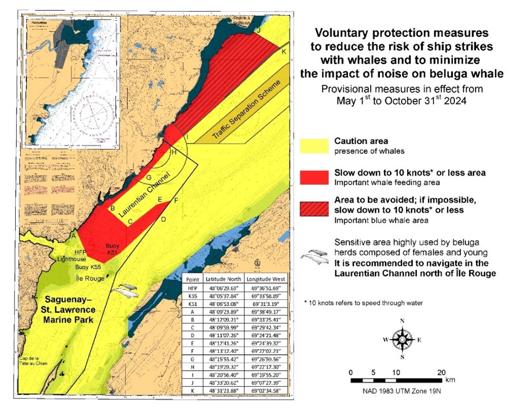
*407/24Saguenay – St. Lawrence Marine Park and Surrounding Waters – Whale Protection
(Recurrent publication of notice *407/24, originally published in the Notices to Mariners – Monthly Eastern Edition 04/2024 publication.)
The waters in and around the Saguenay–St. Lawrence Marine Park are well known for the resident endangered beluga population and the wide diversity of whales that migrate there to feed, particularly between April and November.
REGULATORY PROTECTION MEASURES
All whale species that are found in the St. Lawrence are protected under the Marine Mammal Regulations, pursuant to the Fisheries Act. Within the boundaries of the Marine Park, specific measures are set out in the Marine Activities in the Saguenay–St. Lawrence Marine Park Regulations, pursuant to the establishment of the Saguenay–St. Lawrence Marine Park Act. Any collision with a marine mammal within the Marine Park must immediately be reported to a park warden at 1-866-508-9888. For collisions that occur outside the Marine Park or for any situation involving a marine mammal that is dead or in trouble, contact the emergency network at 1-877-722-5346 or on VHF channel 16.
For more information on the Saguenay–St. Lawrence Marine Park, see notice 5C of the Notices to Mariners Annual Edition 2024.
VOLUNTARY PROTECTION MEASURES
Provisional measures in effect from May 1 to October 31, 2024. See map at the end of this notice.
These measures apply to merchant vessels and cruise ships between Pointe à Boisvert and Cap de la Tête au Chien to prevent collisions with whales. These measures should only be taken when they will not jeopardize navigational safety.
Caution area (yellow area): To reduce the risk of collisions with whales that can be present anywhere in this area, heightened vigilance of navigators is critical. Posting a lookout is recommended in order to increase the chances of seeing the whales and thus taking necessary measures to avoid them. If bypassing the whales is not possible, slow down and wait for the animals to move away to a distance greater than 400 metres (0.215 nautical miles) before resuming original speed. It is more difficult to see the animals at night therefore increased caution is recommended.
Slow down to 10 knots or less area (red area): To reduce the risk of collisions with whales in this feeding area, it is recommended that vessels slow down to a maximum speed through the water of 10 knots and post a lookout. It is further recommended to remain in the Laurentian Channel to the north of Île Rouge to minimize the impact of noise in a sensitive area south of this island, which is highly frequented by herds of beluga whales composed of females and young.
Area to be avoided (hatched red area): To reduce noise and the risk of collisions with whales, vessels should avoid transiting through this area which is highly frequented by blue whales, an endangered species. If the area cannot be avoided, slow down to a speed through the water of 10 knots or less.
*601/24Canadian Hydrographic Service – Nautical Charts
|
Charts |
Main Title |
Scale |
Edition Date |
Published |
Cat# |
Price |
|
Charts Permanently Withdrawn |
||||||
|
3811 |
Harbours in Queen Charlotte Islands/Havres dans Îles de la Reine-Charlotte |
|
||||
*602/24Canadian Hydrographic Service – Electronic Navigational Charts
|
S-57 ENC Number |
Chart Title |
ENC Compilation Scale |
Published |
|
New Charts |
|||
|
CA56PRWA (Edn 1.000) |
CA56PRWA |
1:4 000 |
2024-06-07 |
|
CA56SSAA (Edn 1.000) |
CA56SSAA |
1:6 000 |
2024-06-07 |
|
CA56XRHA (Edn 1.000) |
CA56XRHA |
1:2 000 |
2024-06-07 |
|
CA56YRPA (Edn 1.000) |
CA56YRPA |
1:2 000 |
2024-06-07 |
|
CA573RCA (Edn 1.000) |
CA573RCA |
1:11 000 |
2024-06-07 |
|
CA573RDA (Edn 1.000) |
CA573RDA |
1:11 000 |
2024-06-07 |
|
CA578R4A (Edn 1.000) |
CA578R4A |
1:2 000 |
2024-06-07 |
|
CA57DQTA (Edn 1.000) |
CA57DQTA |
1:4 000 |
2024-06-07 |
|
CA57EQXA (Edn 1.000) |
CA57EQXA |
1:2 000 |
2024-06-07 |
|
CA580QMA (Edn 1.000) |
CA580QMA |
1:2 000 |
2024-06-07 |
|
CA576054 |
Hopedale Harbour |
|
|
|
CA576364 |
Cut Throat Harbour and/et East Harbour |
Cancelled by CA56SSAA |
|
|
CA576531 |
Nain |
Cancelled by CA57EQXA |
|
|
CA576602 |
Postville |
Cancelled by CA56XRHA |
|
|
CA576605 |
Natuashish |
Cancelled by CA578R4A |
|
|
CA576654 |
Voisey Bay Wharf |
Cancelled by CA57DQTA |
|
|
CA576667 |
Landing Beach, Saglek Bay |
Cancelled by CA580QMA |
|
|
CA576737 |
Rigolet |
Cancelled by CA56PRWA |
|
|
CA676476 |
Makkovik |
Cancelled by CA56YRPA |
|
*603/24Canadian Hydrographic Service – Raster Digital Charts (BSB V3)
|
Charts |
Main Title |
Scale |
Edition Date |
Published |
|
|
Charts Permanently Withdrawn |
|||||
|
RM-3811 |
Harbours in Queen Charlotte Islands/Havres dans Îles de la Reine-Charlotte |
|
|
||
*604/24Transport Canada – Ship Safety Bulletin #12, #13, #14 and #15/2024
New Ship Safety Bulletins have recently been
posted on the
Transport Canada website.
To view or download these bulletins, please click on the
links below:
SSB#12/2024 – Guidance on Safe
Lay-up and on Relocating Retired Single-Hulled Oil
Barges
RDIMS#
20313916
SSB#13/2024 – Risky Practice of
Partially Beaching
Barges
RDIMS#
20313895
SSB#14/2024 – Fishing vessels
safety procedures and crew
familiarization
RDIMS#
20162422
SSB#15/2024 – Now in force:
Discharge requirements for cruise
ships
RDIMS#
20360748
Sign up for e-Bulletin to receive an e-mail notice each time a new Ship Safety Bulletin is published on our website.
Contact us at marinesafety-securitemaritime@tc.gc.ca or 1-855-859-3123 (Toll Free).
*605/24Canadian Coast Guard Publication - Amendments to the Notices to Mariners Annual Edition 2024 - Section C, Notice 27A: Guidelines for the Transit of Wide-Beam Vessels and Long Vessels
Several amendments have been made throughout Notice 27A, Guidelines for the Transit of Wide-Beam Vessels and Long Vessels.
The latest version of this notice is available on the Notices to Mariners website.
*606/24Port of Thunder Bay – Unlit Buoys Permanently Changed
Reference chart: 2314
The following unlit buoys have been permanently changed:
|
Aid Name |
LL # |
Position |
Changes |
|
Burke Shoal buoy A7 |
9914 |
48° 20’ 42.8”N |
Aid designator changed |
|
Kaministiquia River Entrance buoy D4 |
9920 |
48° 23’ 50.0”N |
Aid designator changed |
|
Buoy D2 |
9920.5 |
48° 23’ 55.1”N |
Aid designator changed |
|
Main Harbour buoy E2 |
9926 |
48° 26’ 06.8”N |
Aid designator changed |
|
Main Harbour buoy E4 |
9928 |
48° 26’ 00.7”N |
Aid designator changed |
|
Main Harbour buoy E3 |
9929 |
48° 25’ 42.7”N |
Aid designator changed |
|
Main Harbour buoy E6 |
9930 |
48° 25’ 37.8”N |
Aid designator changed |
|
Main Harbour buoy E7 |
9931 |
48° 25’ 13.3”N |
Aid designator changed |
|
Main Harbour buoy E9 |
9932 |
48° 24’ 47.3”N |
Aid designator changed |
|
Main Harbour buoy E11 |
9933 |
48° 24’ 32.3”N |
Aid designator changed |
|
Main Harbour buoy E13 |
9935 |
48° 24’ 16.2”N |
Aid designator changed |
|
Main Harbour buoy E5 |
9936 |
48° 25’ 28.5”N |
Aid designator changed |
|
Main Harbour buoy H2 |
9941 |
48° 26’ 52.8”N |
Aid designator changed |
|
Main Harbour buoy H4 |
9942 |
48° 27’ 03.2”N |
Aid designator changed |
|
McKellar River |
9967 |
48° 22’ 44.2”N |
Unlit buoy permanently discontinued. |
|
Mutton Shoal East Cardinal buoy TB |
9967.1 |
48° 22’ 18.1”N |
East Cardinal unlit buoy established. |
|
McKellar River |
9968 |
48° 22’ 38.6”N |
Unlit buoy permanently discontinued. |
|
9968.1 |
48° 22’ 38.7”N |
Unlit buoy permanently discontinued. |
|
|
Buoy P7/3 |
9968.15 |
48° 22’ 38.5”N |
Unlit buoy permanently discontinued. |
|
McKellar River |
9969 |
48° 22’ 40.6”N |
Unlit buoy permanently discontinued. |
|
Buoy P8/2 |
9969.2 |
48° 22’ 39.3”N |
Unlit buoy permanently discontinued. |
|
Buoy P8/4 |
9969.22 |
48° 22’ 38.8”N |
Unlit buoy permanently discontinued. |
|
McKellar River |
9970 |
48° 22’ 38.6”N |
Unlit buoy permanently discontinued. |
|
McKellar River |
9971 |
48° 22’ 39.5”N |
Unlit buoy permanently discontinued. |
(D2024-052 to 062, 064, 066, 067, 069 to 078)
*607/24Sydney Harbour – Unlit Buoys Aid Designators Changed
Reference chart: 4266
The designators of the following unlit buoys have been permanently changed:
|
Aid Name |
LL # |
Position |
Changes |
|
Sydney River buoy S25 |
5777.04 |
46° 07’ 18.5”N |
Aid designator changed |
|
Sydney River buoy S26 |
5777.05 |
46° 07’ 21.5”N |
Aid designator changed |
|
Sydney River buoy S21 |
5777.1 |
46° 08’ 10.0”N |
Aid designator changed |
(G2024-006, 007, 008)
*608/24Harbours on the North Shore / Hâvres sur la Côte Nord – Unlit Buoys Repositioned
Reference chart: 4425
The following unlit buoys have been repositioned to the following coordinates:
|
Aid Name |
LL # |
Position |
|
Savage Harbour |
6046.95 |
46° 25’ 44.3”N 062° 50’ 09.9”W |
|
Savage Harbour |
6046.97 |
46° 25’ 35.2”N 062° 50’ 20.5”W |
(G2024-086, 092)
*609/24Détroit de Northumberland / Northumberland Strait: Partie Ouest / Western Portion: Ports / Harbours – Unlit Buoys Permanently Changed
Reference chart: 4909
The following unlit buoys have been permanently changed:
|
Aid Name |
LL # |
Position |
Changes |
|
Richibucto Harbour Approach buoy Q4 |
6132.1 |
46° 42’ 43.6”N |
Unlit buoy has been repositioned. |
|
Richibucto NW. Branch buoy QA4 |
6148.1 |
46° 41’ 58.0”N |
Size of the buoy reduced. |
|
Richibucto buoy Q14 |
6150.64 |
46° 42’ 36.1”N |
Unlit buoy has been repositioned. |
(G2024-100, 101, 126)
*610/24Lac Saint-Jean – Unlit Buoys Repositioned
Reference chart: 6100
The following unlit buoys have been repositioned to the following coordinates:
|
Aid Name |
LL # |
Position |
|
La Belle Rivière buoy |
12905 |
48° 29’ 11.9”N 71° 47’ 47.4”W |
|
La Belle Rivière buoy |
12917 |
48° 29’ 03.7”N 71° 47’ 32.5”W |
(Q2024-173, 174)
Reminder – Comment Period for Active Preliminary Notices
This is a reminder that the comment period is still open for the following active Preliminary notices:
|
Notice # |
Reference Chart # |
Aids Affected |
Intent of Notice |
|
Newfoundland and Labrador Coast |
|||
|
4679 |
208 |
Fog Signal to be Discontinued |
|
Please refer to the Notices to Mariners - Monthly Summary of Temporary and Preliminary Notices publication for details.
Newfoundland and Labrador Coast
Temporary Notices
*611(T)/24Great St. Lawrence Harbour and / et Lamaline Harbour – Aid to Navigation Temporarily Discontinued
Reference chart: 4642
The following aid to navigation is temporarily discontinued:
|
Aid Name |
LL # |
Position |
|
St. Lawrence Wharf |
73.1 |
46° 54’ 59.1”N 55° 23’ 20.8”W |
(N2024-093T)
Preliminary Notices
No notices applicable for this edition.
Atlantic Coast
Temporary Notices
No notices applicable for this edition.
Preliminary Notices
No notices applicable for this edition.
Temporary Notices
*612/24Ottawa to/à Smiths Falls – Marine Works – Bridge Repair Completed
Reference: Notice 613(T)/23 is cancelled (Chart 1512, 1515).
Repair work on the pillars of the MacDonald Cartier Bridge are now completed.
Preliminary Notices
No notices applicable for this edition.
SECTION 2 - CHART CORRECTIONS
1310 - Section B-C - New Edition - 07-JUN-2019 - NAD 1983
(See Chart 1, P20.2)
(See Chart 1, P20.2)
1312 - Lac Saint-Pierre - New Edition - 10-MAY-2019 - NAD 1983
(See Chart 1, I10)
2050 - Oshawa Harbour - New Edition - 04-OCT-2019 - World Geodetic System 1984
(See Chart 1, Qb)
to 43°51′44.9″N 078°49′07.1″W
(See Chart 1, Qb)
to 43°51′49.9″N 078°49′12.5″W
2202 - Port Severn to/à Penetang Harbour - Sheet/Feuille 1 - New Edition - 05-JAN-2007 - NAD 1983
(See Chart 1, Qb)
(See Chart 1, Qb)
to 44°49′22.0″N 079°52′44.1″W
(See Chart 1, Qc)
(See Chart 1, Qc
to 44°48′24.7″N 079°51′54.7″W
2235 - Cape Hurd to/à Lonely Island - New Edition - 01-OCT-2021 - World Geodetic System 1984
(See Chart 1, Qb)
2241 - Port Severn to/à Christian Island - New Chart - 30-JUL-1999 - NAD 1983
(See Chart 1, Qb)
(See Chart 1, Qb)
to 44°49′22.0″N 079°52′44.1″W
(See Chart 1, Qc)
(See Chart 1, Qc
to 44°48′24.7″N 079°51′54.7″W
2251 - Meldrum Bay to/à St.Joseph Island - New Chart - 11-APR-1986 - NAD 1927
(See Chart 1, Q80, Q81)
2273 - South Baymouth Harbour and Approaches - New Edition - 28-AUG-2015 - World Geodetic System 1984
(See Chart 1, Qb)
(See Chart 1, Qc)
2297 - Duck Islands to DeTour Passage - New Edition - 25-MAR-2016 - Unknown
(See Chart 1, Q80, Q81)
2326 - Middlebrun Bay to/à Washington Island - New Chart - 24-JUL-2020 - NAD 1983
(See Chart 1, P16)
4003 - Cape Breton to / à Cape Cod - New Edition - 21-MAR-2003 - NAD 1983
(See Chart 1, Q58)
4012 - Yarmouth to / à Halifax - New Edition - 14-FEB-2003 - NAD 1983
(See Chart 1, Q58)
(See Chart 1, P16)
4013 - Halifax to / à Sydney - New Edition - 06-SEP-2002 - NAD 1983
(See Chart 1, Q58)
(See Chart 1, K29, B7, I3)
(See Chart 1, P16)
(See Chart 1, P16)
4116 - Approaches to / Approches à Saint John - New Edition - 31-AUG-2007 - NAD 1983
(See Chart 1, Q130.3)
4141 - Saint John to / à Grand Bay including / y compris Kennebecasis River - Sheet / Feuille A-B - New Edition - 30-OCT-2009 - NAD 1983
(See Chart 1, Q130.3)
(See Chart 1, Qc)
(See Chart 1, Qb)
4227 - Country Harbour to / au Ship Harbour - New Chart - 24-MAY-1991 - NAD 1983
(See Chart 1, P16)
4233 - Cape Canso to / à Country Island - New Chart - 11-JAN-1991 - NAD 1983
(See Chart 1, P16)
4233 - TOR BAY - NEW CHART - 11-JAN-1991 - NAD 1983
(See Chart 1, P16)
4236 - Ship Harbour and Approaches / et les approches - New Edition - 13-JUL-2001 - NAD 1983
(See Chart 1, P16)
4236 - Taylors Head to / à Shut-in Island - New Edition - 13-JUL-2001 - NAD 1983
(See Chart 1, P16)
4237 - Approaches to / Approches de Halifax Harbour - New Edition - 28-MAY-2021 - World Geodetic System 1984
(See Chart 1, Q58)
4266 - North Sydney - New Edition - 28-FEB-2014 - NAD 1983
(See Chart 1, Qb)
4266 - Sydney Harbour - New Edition - 28-FEB-2014 - NAD 1983
(See Chart 1, Qb)
4320 - Egg Island to / à West Ironbound Island - New Edition - 26-SEP-1997 - NAD 1983
(See Chart 1, K29, B7, I3)
(See Chart 1, Q58)
(See Chart 1, P16)
4321 - Cape Canso to / à Liscomb Island - New Edition - 08-OCT-2004 - NAD 1983
(See Chart 1, P16)
4376 - Louisbourg Harbour - New Edition - 14-JUN-2002 - NAD 1983
(See Chart 1, A14)
(See Chart 1, A14)
(See Chart 1, A14)
4381 - Chester Harbour - New Edition - 28-APR-2023 - World Geodetic System 1984
(See Chart 1, P16)
4381 - Mahone Bay - New Edition - 28-APR-2023 - World Geodetic System 1984
(See Chart 1, P16)
(See Chart 1, P16)
(See Chart 1, K29, B7, I3)
4381 - Mahone Harbour - New Edition - 28-APR-2023 - World Geodetic System 1984
(See Chart 1, P16)
4386 - St. Margaret's Bay - New Edition - 16-JUL-2004 - NAD 1983
(See Chart 1, K29, B7, I3)
4486 - Baie des Chaleurs / Chaleur Bay - New Edition - 19-FEB-1999 - NAD 1983
(See Chart 1, P1)
4522 - Approaches to / Approches À La Scie Harbour - New Edition - 10-OCT-2003 - NAD 1983
(See Chart 1, P1)
4522 - La Scie Harbour - New Edition - 10-OCT-2003 - NAD 1983
(See Chart 1, P1)
4617 - Red Island to / à Pinchgut Point - New Edition - 30-APR-2010 - NAD 1983
(See Chart 1, Qc)
4841 - Argentia - New Edition - 29-MAY-2015 - NAD 1983
(See Chart 1, Qc)
4912 - Miramichi - New Edition - 27-JAN-2006 - NAD 1983
(See Chart 1, I10)
(See Chart 1, I10)
(See Chart 1, I10)
(See Chart 1, I10)
(See Chart 1, I10)
(See Chart 1, I10)
(See Chart 1, I10)
(See Chart 1, I10)
(See Chart 1, I10)
(See Chart 1, I10)
(See Chart 1, I10)
(See Chart 1, I10)
(See Chart 1, I10)
(See Chart 1, I10)
(See Chart 1, I10)
(See Chart 1, I10)
(See Chart 1, I10)
(See Chart 1, I10)
(See Chart 1, I10)
(See Chart 1, I10)
(See Chart 1, I10)
(See Chart 1, I10)
4912 - Continuation A - New Edition - 27-JAN-2006 - NAD 1983
(See Chart 1, I10)
(See Chart 1, I10)
(See Chart 1, I10)
(See Chart 1, I10)
4921 - Bonaventure - New Edition - 02-DEC-2016 - NAD 1983
(See Chart 1, I10)
(See Chart 1, I10)
(See Chart 1, Ka, Fb)
4921 - Port-Daniel-Gascons - New Edition - 02-DEC-2016 - NAD 1983
(See Chart 1, I22)
4921 - Quai / Wharf Grande-Rivière - New Edition - 02-DEC-2016 - NAD 1983
(See Chart 1, I10)
(See Chart 1, I10)
(See Chart 1, I10)
4921 - Sainte-Thérèse-de-Gaspé - New Edition - 02-DEC-2016 - NAD 1983
(See Chart 1, I22)
(See Chart 1, I22)
(See Chart 1, I22)
(See Chart 1, I10)
(See Chart 1, I10)
(See Chart 1, I10)
4934 - Boughton Bay to Basin Head Harbour - New Chart - 30-JUN-2023 - World Geodetic System 1984
(See Chart 1, Qb)
4935 - Murray Harbour to/à Boughton Bay - New Chart - 18-JAN-2019 - NAD 1983
(See Chart 1, Qb)
6035 - Lake Nipissing / Lac Nipissing(Eastern Portion / Partie est) - New Edition - 28-DEC-2001 - NAD 1983
(See Chart 1, Qc)
(See Chart 1, Qc)
(See Chart 1, Qd)
6432 - Kilometre/Kilomètre 1500 to/à Inuvik East Channel - New Edition - 27-APR-2018 - NAD 1983
(See Chart 1, I10)
(See Chart 1, Qb)
to 67°49′19.1″N 134°12′11.8″W
(See Chart 1, Qb)
(See Chart 1, Qb)
to 67°50′02.5″N 134°12′33.4″W
7664 - Liverpool Bay - New Chart - 28-FEB-1986 - NAD 1927
Download Patch - https://www.notmar.gc.ca/chsftp/patches/7664_6605246_1_202405091058.pdf
8007 - Halifax to / à Sable Island / Île de Sable, Including / y compris Emerald Bank / Banc d'Émeraude and / et Sable Island Bank / Banc de l'Île de Sable - New Edition - 30-AUG-2002 - NAD 1983
(See Chart 1, Q58)
(See Chart 1, K29, B7, I3)
(See Chart 1, P16)
SECTION 3 - RADIO AIDS TO MARINE NAVIGATION CORRECTIONS
*613/24Radio Aids to Marine Navigation 2024 (Atlantic, St. Lawrence, Great Lakes, Lake Winnipeg, Arctic and Pacific)
Page 1-1
AMEND AS FOLLOWS:
1.1.1.1 Southern Resident Killer Whale
a)Speed Restricted Zone NAVWARN (Effective June 1,
2023 2024 until November 30, 2023 2024) information is available in
the
SRZ Navigational
Warning
SRZ Navigational
Warning.
b)Interim Sanctuary Zone NAVWARN (Effective June 1,
2023 2024 until November 30, 2023 2024) information is available in
the
ISZ Navigational
Warning
ISZ Navigational
Warning.
c)400 Metres Approach Distance and Ban Against
Positioning Vessel in Path of a Killer Whale remain in effect
until May 31, 2024 2025.
Note: Roseway Basin Seasonal Area is to be avoided. In order to significantly reduce the risk of ship strikes of the highly endangered North Atlantic Right Whale, it is recommended that ships of 300 tons gross tonnage and upwards in transit during the period of June 1st through December 31st should avoid this area. Any sightings are to be reported to Halifax MCTS.
Page 2-6
ADD AS FOLLOWS:
2.1.2Iqaluit, Nunavut
MMSI:
003160023Call Sign: VFF
Hours: H24
Services in English and in French.
All communications with Canadian Coast Guard Marine
Communications and Traffic Services Centres are recorded.
Open from approximately mid-May until mid-December.
Opening and closing will be announced by Navigational
Warning.
For Radio Services, call Iqaluit Coast Guard Radio.
Marine Safety Information can also be received via email upon
request.
Mailing Address:
Fisheries and Oceans Canada
Canadian Coast Guard
Officer-in-Charge – MCTS Operations
Iqaluit MCTS Centre / NORDREG CANADA
1063
Niuraivik Lane
Iqaluit, NU X0A 3H0
Telephone:867-979-5269 MCTS
Operations (East)
867-979-0310 MCTS Operations (West)
867-979-5724 NORDREG Operations
Facsimile:867-979-4264 MCTS/NORDREG
Operations
Telex
(Telefax): 063-15529 NORDREG CDA
Email:IQANORDREG@INNAV.GC.CA
(operations)
NAVWARN.MCTSIqaluit@innav.gc.ca
navarea17.18@innav.gc.ca NAVAREA XVII and XVIII
Pages 2-8 and 2-9
AMEND AS FOLLOWS:
Table 2-4 - Iqaluit MCTS/VFF – Broadcasts
|
Time UTC |
Site |
Frequency or Channel |
Contents |
|
01:10 |
Coral Harbour |
2514J3E |
Radiotelephony •Technical marine synopsis and forecasts on request for marine forecast areas : 151, 152, 153, 154, 155, 156, 157, 158, 159, 160, 161, 162, 163, 164, 310, 311 and 312. •Navigational warnings “Series A” for all NORDREG waters bound by Shipping Safety Control Zones 8, 14 and 16, including Southern Hudson Bay, James Bay, Chesterfield Inlet and Baker Lake. |
|
Coral Harbour |
6507J3E |
||
|
01:15 |
Inuvik |
6218.6J3E |
Radiotelephony •Technical marine synopsis and forecasts on request for marine forecast areas: 180, 190, 191, 192, 193, 194, 195, 112, and 113 •Navigational warnings “Series A” for Great Slave Lake, Hay River, Mackenzie River and Mackenzie Delta bound by forecast areas 112 and 113. |
|
Hay River |
4363J3E |
||
|
Parson’s Lake and Enterprise |
Ch26 |
||
|
Yellowknife |
Ch85 |
||
|
02:35 |
Cambridge Bay |
4363J3E |
Radiotelephony
•Technical
marine synopsis and weather on request for marine
forecast areas: 111 to 122 inclusive •Navigational warnings “Series A” for all NORDREG waters west of Taloyoak. |
|
Inuvik |
6218.6J3E |
||
|
03:00 |
Iqaluit |
490F1B |
NAVTEX: (S) French •Weather for marine forecast areas 143, 144, 145, 147, 148, 149 and 150. |
|
Iqaluit |
518F1B |
NAVTEX: (T) English •Weather for marine forecast areas 143, 144, 145, 147, 148, 149 and 150. |
|
|
03:30 |
Iqaluit |
8416.5F1B |
HF NBDP •METAREA bulletins for METAREAS XVII and XVIII and the Northwestern part of METAREA IV within Canadian waters. •NAVAREA warnings for NAVAREAs XVII and XVIII. |
|
… |
… |
… |
… |
|
23:10 |
Resolute |
2582J3E |
Radiotelephony •Technical marine synopsis and forecasts on request for marine forecast areas 125 to 138. •Navigational warnings “A Series” for all NORDREG waters bound by Shipping Safety Control Zones 1, 2, 3, 5, 6, 9 and 13. |
Page 2-28
DELETE AS FOLLOWS:
MMSI:
003160029Call Sign: VBR
Hours: H24
Services in English and in French.
All communications with Canadian Coast Guard Marine
Communications and Traffic Services Centres are recorded.
For Radio Services, call Prescott Coast Guard Radio.
Coordinates
Mailing Address:
Fisheries and Oceans Canada
Canadian Coast Guard
Officer-in-Charge – MCTS Operations
Prescott MCTS Centre
P.O. Box 1000
401 King Street West
Prescott, ON K0E 1T0
Telephone:613-925-4471 MCTS
Operations
Telephone:613-925-0666 NAVWARN Desk / NAVAREA XVII and XVIII
Facsimile:613-925-4519
Email:
Safety.Prescott@innav.gc.ca
Prescott MCTS
navarea17.18@innav.gc.ca NAVAREA XVII and XVIII
NAVWARN.MCTSPrescott@innav.gc.ca
AMEND AS FOLLOWS:
3.8.4Pre-Arrival Information Report (PAIR)
The Canadian Marine Transportation Security
Regulations (MTSR) requires a Pre-Arrival Information
Report (PAIR) to be filed prior to entry into Canadian waters.
Message format and contact information are found in Part
4.2.9 4.2.8.
Page 4-76
DELETE AS FOLLOWS:
4.3.11 Inspection of Radio Apparatus
Vessels Inspected under the Agreement Between Canada and the United States of America for Promotion of Safety on the Great Lakes by Means of Radio, 1973 (GLA 1973).
As of November 2, 2023, the
GLA
1973 will be terminated. After
this, vessels that were previously inspected under the
GLA
1973 will no longer need a
radio inspection every 13 months. Instead, these vessels will
need to follow the radio inspection timeline set out in the
policy on the
Validity period of a Radio
Inspection Certificate issued under the Navigation Safety
Regulations, 2020
After November 2, 2023, Canadian
vessels operating in the Great Lakes, that are subject to radio
inspections, will be eligible for a radio inspection
certificate with a validity of up to 4 years.
This is outlined in section
240 of the
Navigation Safety Regulations,
2020 (NSR 2020)
and the
Policy on the
Carriage requirements are not
changing. Vessels must still comply with Sections 205
and 253 (5) of the
NSR
2020.
The new certificates will be phased
in according to the table below.
Any inspection conducted on or after
June 1, 2024, will be subject to a new certificate with a
validity of up to 4 years.
Great Lakes radio inspection
certificates issued before November 2, 2023, will remain valid
until their expiration dates.
Timeline for implementing new validity period
|
|
|
|
|
|
|
|
|
|
|
|
|
|
|
ADD AS FOLLOWS:
4.3.11.1 Ship Radio Inspection Contacts
CCG Newfoundland and Labrador
Fisheries and Oceans Canada
Telephone and Fax: 1-888-454-3177
Outside Canada
Telephone Facsimile: 709-772-3467
Email: xnfltsc@dfo-mpo.gc.ca
https://e-nav.ccg-gcc.gc.ca/sri
Charlottetown, Prince Edward Island
Senior Technologist
Fisheries and Oceans Canada
Canadian Coast Guard
Unit 2 – 184 John YEO Drive
Charlottetown, PE C1C 3J3
Telephone:902-407-7521
Facsimile: 902-407-7435
Email: xmartsc@dfo-mpo.gc.ca
https://e-nav.ccg-gcc.gc.ca/sri
Saint John, New Brunswick
Senior Technologist
Fisheries and Oceans Canada
Canadian Coast Guard
175 McIlveen Drive
Saint John, NB E2J 4Y6
Telephone:
506-636-4743
Facsimile: 506-636-5000
Email: xmartsc@dfo-mpo.gc.ca
https://e-nav.ccg-gcc.gc.ca/sri
Senior Technologist
Fisheries and Oceans Canada
Canadian Coast Guard
P.O. Box 1006
Dartmouth, NS B2Y 4A2
Telephone:
902-407-7521
Facsimile: 902-407-7435
Email: xmartsc@dfo-mpo.gc.ca
https://e-nav.ccg-gcc.gc.ca/sri
Sydney, Nova Scotia
Senior Technologist
Fisheries and Oceans Canada
Canadian Coast Guard Ships
1190 Westmount Road
Sydney, NS B1R 2J6
Telephone:
902-407-7521
Facsimile: 902-407-7435
Email: xmartsc@dfo-mpo.gc.ca
https://e-nav.ccg-gcc.gc.ca/sri
Yarmouth, Nova Scotia
Senior Technologist
Fisheries and Oceans Canada
Canadian Coast Guard
215 Main Street
Yarmouth, NS B5A 1C6
Telephone:902-407-7521
Facsimile: 902-407-7435
Email: xmartsc@dfo-mpo.gc.ca
https://e-nav.ccg-gcc.gc.ca/sri
SECTION 4 - CANADIAN SAILING DIRECTIONS CORRECTIONS
The following Canadian Sailing Directions volumes have recently been updated on the Canadian Hydrographic Service website.
|
No. |
Title |
|
Atlantic Coast |
|
|
ATL 106 |
Gulf of Maine and Bay of Fundy |
|
ATL 107 |
Saint John River |
|
Pacific Coast |
|
|
PAC 201 |
Juan de Fuca Strait and Strait of Georgia |
Each volume includes a section entitled “Record of Changes” which lists all updates that are incorporated during the current calendar year.
SECTION 5 - LIST OF LIGHTS, BUOYS AND FOG SIGNALS CORRECTIONS
The amendments are highlighted and deletions are crossed out. For general and region-specific
information on the List of Lights, click on the following links:
Newfoundland and Labrador Coast,
Atlantic Coast,
Inland Waters and
Pacific Coast.
NEWFOUNDLAND AND LABRADOR COAST
| No. | Name |
Position ----- Latitude N. Longitude W. |
Light Characteristics |
Focal Height in m. above water |
Nominal Range |
Description ----- Height in meters above ground |
Remarks ----- Fog Signals |
|||
|---|---|---|---|---|---|---|---|---|---|---|
PLACENTIA BAY (LL 14.4 – 79) |
||||||||||
| 78.3 | Lamaline light buoy PG4 |
Delete from
list. Chart:4642 Edn 06/24 (N24-118) |
||||||||
FORTUNE BAY (LL 100 – 120.1) |
||||||||||
|
113 H0314 |
Ragged Point Light |
Bay L’Argent. 47 33 28.0 054 52 34.0 |
Fl | W | 5s | 62.2 | 9 |
Rectangular
skeleton tower, red and white rectangular daymark. 3.8 |
Flash 1 s; eclipse 4 s. Year round. Chart:4831 Edn 06/24 (N24-088) |
|
| 118.1 | St. Jacques Harbour Wharf Light |
47 29
16.5 055 25 15.4 |
Fl | Y | 5s | ….. | 2 | Mast. |
Flash 1 s; eclipse
4 s. Operates 24 h. Year round. Chart:4831 Edn 06/24 (N24-106) |
|
|
119.5 H0301 |
Boxey Breakwater Light |
47 27 05.2 055 33 28.2 |
Fl | G | 5s | 3.5 | 4 |
Mast. 2.6 |
Flash 1 s; eclipse
4 s. Seasonal. Chart:4831 Edn 06/24 (N24-107) |
|
SOUTHWEST COAST (LL 121 – 172) |
||||||||||
| 140.51 | Turnip Island Rock light buoy QR2 |
47 30 46.1 057 22 36.6 |
Fl | R | 4s | ..... | ..... | Red spar, marked “QR2”. |
Year round. Chart:4825 Edn 06/24 (N24-116) |
|
|
149.2 H0243 |
Harbour Le Cou Breakwater Light |
47 37 28.0 058 40 55.0 |
Fl | G | 5s | 3.5 | 2 |
Mast. 2.3 |
Flash 1 s;
eclipse 4
s. Seasonal. Chart:4639 Edn 06/24 (N24-098) |
|
|
150 H0242.1 |
Rose Blanche East Wharf Light |
47 36 35.0 058 41 37.2 |
Fl | R | 5s | 3.2 | 4 |
Mast. 2.6 |
Flash 1 s; eclipse
4 s. Seasonal. Chart:4639 Edn 06/24 (N24-099) |
|
|
150.1 H0242.2 |
Rose Blanche Ferry Wharf Light |
47 36 53.0 058 41 58.5 |
Fl | Y | 5s | 4.2 | 2 |
2.4 |
Flash 1 s; eclipse
4 s. Year round. Chart:4639 Edn 06/24 (N24-097) |
|
WEST COAST (LL 173 – 208.06) |
||||||||||
| 176.35 | Crabbes River Light |
48 13
08.5 058 51 47.5 |
Fl | W | 5s | ….. | 3 | Pipe tower. |
Flash 1 s; eclipse
4 s. Operates 24 h. Year round. Chart:4022 Edn 06/24 (N24-096) |
|
| 178.14 | St. George’s Harbour Inner light buoy XG3 |
48 25 57.4 058 29 17.6 |
Q | G | 1s | ..... | ..... | Green spar, marked “XG3”. |
Seasonal. Chart:4885 Edn 06/24 (N24-113) |
|
| 178.15 | St. George’s Harbour Inner light buoy XG4 |
48 26
00.5 058 29 20.0 |
Fl | R | 4s | ..... | ..... | Red spar, marked “XG4”. |
Seasonal. Chart:4885 Edn 06/24 (N24-114) |
|
|
185.8 H0201.5 |
Fox Brook South Wharf Light |
48 41 42.7 058 40 56.6 |
Fl | R | 3s | 3.1 | 2 | Cylindrical mast. |
Flash 0.5 s; eclipse 2.5 s. Operates 24 h. Seasonal. Chart:4659 Edn 06/24 (N24-087) |
|
STRAIT OF BELLE ISLE (LL 211 – 234) |
||||||||||
| 216.55 | Black Duck Cove Inner light buoy XK4 |
51 11 51.0 056 47 56.4 |
Fl | R | 4s | ….. | ….. | Red spar, marked “XK4”. |
Seasonal. Chart:4667 Edn 06/24 (N24-117) |
|
WHITE BAY (LL 235 – 269.2) |
||||||||||
|
253 H0719 |
Bad Rock Light |
Chimmey Channel. 50 46 58.7 056 09 35.9 |
Fl | G | 4s | 4.6 | 6 |
Square skeleton tower, green and white rectangular
daymark
facing 4.3 |
Seasonal. Chart:4538 Edn 06/24 (N24-076) |
|
|
265 H0694.5 |
Pacquet Wharf Light |
NW. end of Pacquet Harbour. 49 59 25.5 055 52 27.0 |
Fl | R | 5s | 3.5 | 2 |
Mast. 2.4 |
Flash 1 s; eclipse
4 s. Seasonal. Chart:4821 Edn 06/24 (N24-100) |
|
|
267 H0692.4 |
La Scie Harbour Breakwater Light |
49 57 42.5 055 36 10.3 |
Fl | R | 5s | 5.0 | 3 |
2.4 |
Flash 1 s; eclipse
4 s. Seasonal. Chart:4522 Edn 06/24 (N24-101) |
|
|
267.3 H0692.55 |
La Scie Harbour Wharf Light |
49 57 46.2 055 36 13.8 |
Fl | G | 5s | 4.3 | 3 |
|
Flash 1 s; eclipse
4 s. Seasonal. Chart:4522 Edn 06/24 (N24-102) |
|
|
268.5 H0696.5 |
Coachman's Cove Wharf Light |
50 03 01.1 056 06 35.3 |
Fl | G | 5s | ….. | 2 |
|
Flash 1 s; eclipse
4 s. Operates 24 h. Seasonal. Chart:4521 Edn 06/24 (N24-103) |
|
NEWFOUNDLAND AND LABRADOR COAST (LL 269.99 – 325.23) |
||||||||||
| 325.09 | Strathcona Run light buoy NS5 |
Delete from
list. Chart:5052 Edn 06/24 |
||||||||
NOTRE DAME BAY (LL 326 – 395) |
||||||||||
|
335.5 H0680.7 |
Beachside Wharf Light |
49 38 34.0 055 53 44.8 |
Fl | R | 5s | 3.6 | 4 |
Mast. 2.4 |
Flash 1 s; eclipse 4 s. Seasonal. Chart:4585 Edn 06/24 (N24-104) |
|
| 336.28 | Shoal Arm Wharf |
Delete from
list. Chart:4523 Edn 06/24 (N24-105) |
||||||||
|
389 H0597 |
Green Island Light |
Rocky Bay. 49 26 55.9 054 13 41.6 |
Fl | W | 5s | 9.8 | 5 | Rectangular skeleton tower, red and white rectangular daymark. |
Flash 1 s; eclipse 4 s. Visible 180°. Year round. Chart:4530 Edn 06/24 (N24-111) |
|
|
393.4 H0590 |
Grassy Island Light |
Ladle
Cove. 49 28 28.9 054 03 17.6 |
Fl | R | 5s | ..... | 4 |
Square skeleton tower, red and white rectangular
daymark. 4.3 |
Flash 1 s; eclipse
4 s. Seasonal. Chart:4530 Edn 06/24 (N24-112) |
|
|
393.7 H0590.2 |
Ladle Cove Wharf Light |
49 28 25.0 054 03 27.0 |
Fl | R | 5s | ..... | 3 |
Red
mast. 2.6 |
Flash 1 s; eclipse
4 s. Seasonal. Chart:4530 Edn 06/24 (N24-108) |
|
BONAVISTA BAY (LL 396 – 449.5) |
||||||||||
| 439.6 | Salvage light buoy JSA6 |
48 41 26.5 053 38 38.0 |
Fl | R | 4s | ..... | ..... | Red spar, marked “JSA6”. |
Seasonal. Chart:4855 Edn 06/24 (N24-091) |
|
| 439.61 | Salvage light buoy JSA3 |
48 41 31.4 053 38 42.9 |
Fl | G | 4s | ..... | ..... | Green spar, marked “JSA3”. |
Seasonal. Chart:4855 Edn 06/24 (N24-090) |
|
|
442.14 H0540.75 |
Sweet Bay Wharf Light |
48 26 45.8 053 39 04.3 |
Fl | G | 5s | ..... | 2 |
2.6 |
Flash 1 s; eclipse
4 s. Seasonal. Chart:4855 Edn 06/24 (N24-109) |
|
|
442.519 H0540.68 |
Summerville Wharf Light |
48 27 14.0 053 33 17.2 |
Fl | Y | 5s | ..... | 2 |
|
Flash 1 s; eclipse
4 s. Seasonal. Chart:4855 Edn 06/24 (N24-110) |
|
TRINITY BAY (LL 450.1 – 471.51) |
||||||||||
|
463 H0522 |
Horse Chops Fog Signal Station |
Delete from
list. Chart:4853 Edn 06/24 (N24-092) |
||||||||
| 467.45 | Islington Wharf Light |
47 45
45.2 053 28 50.5 |
Fl | G | 5s | ….. | 2 | Pipe tower. |
Flash 1 s; eclipse
4 s. Operates 24 h. Seasonal. Chart:4851 Edn 06/24 (N24-085) |
|
| 467.506 | Heart’s Delight North Wharf Light |
47 46
39.4 053 28 17.3 |
Fl | G | 5s | ….. | 2 | Pipe tower. |
Flash 1 s; eclipse
4 s. Operates 24 h. Seasonal. Chart:4851 Edn 06/24 (N24-086) |
|
|
467.51 H0510.8 |
Heart’s Delight Breakwater Light |
47 46 19.9 053 28 00.5 |
Fl | R | 5s | ….. | 2 | Cylindrical mast. |
Flash 1 s; eclipse
4 s. Operates 24 h. Seasonal. Chart:4851 Edn 06/24 (N24-094) |
|
CONCEPTION BAY (LL 471.7 – 498.2) |
||||||||||
|
475 H0494 |
Western Bay Head Light |
47 53 11.9 053 03 23.6 |
Fl | W | 5s | 28.8 | 10 |
Rectangular
skeleton tower, red rectangular daymark
with white
horizontal band. 6.6 |
Flash 1 s;
eclipse 4
s. Year round. Chart:4850 Edn 06/24 (N24-095) |
|
ATLANTIC COAST
| No. | Name |
Position ----- Latitude N. Longitude W. |
Light Characteristics |
Focal Height in m. above water |
Nominal Range |
Description ----- Height in meters above ground |
Remarks ----- Fog Signals |
|||
|---|---|---|---|---|---|---|---|---|---|---|
CAPE BRETON ISLAND, N.S. (LL 704.85 – 882.5) |
||||||||||
|
782 783H0761 H0761.1 |
Sydney range |
| | | | | | | | | | | | |
On point, E. side of North West Arm. 216°35’ 3352.8 m46 10 39.7 060 15 30.0 from front. |
F
F
|
G
G
|
…..
…..
|
26.4
63.4
|
…..
…..
|
White octagonal tower with red upper portion and red
vertical stripe. Square skeleton tower, white daymark with red
stripe.15.1 9.6 |
Visible in line of range. Operates 24 h. Year round. Visible in line of range. Operates 24 h. Year round. Chart:4266 Edn 06/24 (G24-108, 109, 149, 151) |
|
784 785H0764 H0764.1 |
Sydney South Arm range |
| | | | | | | | | | | |
Near N. extremity of point. 160°34’ 140.4 m from front.
46 09 26.5 060 12 13.3 |
F
F
|
G
G
|
…..
…..
|
14.7
21.5
|
…..
16
|
Triangular skeleton tower, white daymark with red
vertical stripe. Triangular skeleton tower, white daymark with red
vertical stripe.
6.7 |
Visible in line of range. Operates 24 h. Year round. Operates 24 h. Year round. Chart:4266 Edn 06/24 (G24-105, 107, 152, 160) |
| 785.5 | Barachois light buoy S18 |
At entrance to creek. 46 09 32.8 060 12 53.0 |
Fl | R | 4s | ….. | ….. | Red spar, marked “S18”. |
Year round. Chart:4266 Edn 06/24 (G24-009) |
|
| 786 | Battery Point light buoy S19 |
Off point. 46 08 53.5 060 12 26.5 |
Fl | G | 4s | ….. | ….. | Green spar, marked “S19”. |
Year round. Chart:4266 Edn 06/24 (G24-010) |
|
| 787 | Dobsons Point light buoy S20 |
On edge of shoal. 46 08 27.7 060 12 13.7 |
Fl | R | 4s | ….. | ….. | Red spar, marked “S20”. |
Year round. Chart:4266 Edn 06/24 (G24-011) |
|
| 788 | Sydney Harbour South Arm light buoy S23 |
46 07 49.0 060 12 11.5 |
Fl | G | 4s | ….. | ….. | Green spar, marked “S23”. |
Seasonal. Chart:4266 Edn 06/24 (G24-005) |
|
| 789.11 | Sydney Harbour light buoy S13 |
46 12
03.3 060 13 20.7 |
Q | G | 1s | ….. | ….. | Green spar, marked “S13”. |
Operates 24
h. Year round. Chart:4266 Edn 06/24 (G24-111, 145) |
|
| 789.12 | Sydney Harbour light buoy S14 |
46 11
36.9 060 13 26.2 |
Fl | R | 4s | ….. | ….. | Red spar, marked “S14”. |
Operates 24
h. Year round. Chart:4266 Edn 06/24 (G24-113, 146) |
|
| 789.14 | Sydney Harbour light buoy S16 |
46 10
57.4 060 13 05.4 |
Fl | R | 4s | ….. | ….. | Red spar, marked “S16”. |
Operates 24
h. Year round. Chart:4266 Edn 06/24 (G24-114, 147) |
|
| 789.2 | Sydney Harbour light buoy S4 |
46 15
26.1 060 10 35.3 |
Fl | R | 4s | ….. | ….. | Red spar, marked “S4”. |
Operates 24
h. Year round. Chart:4266 Edn 06/24 (G24-120, 140) |
|
| 789.3 | Sydney Harbour light buoy S6 |
46 14
32.4 060 11 31.0 |
Fl | R | 4s | ….. | ….. | Red spar, marked “S6”. |
Operates 24
h. Year round. Chart:4266 Edn 06/24 (G24-118, 141) |
|
| 789.6 | Sydney Harbour light buoy S8 |
46 13
38.2 060 12 27.1 |
Fl | R | 4s | ….. | ….. | Red spar, marked “S8”. |
Operates 24
h. Year round. Chart:4266 Edn 06/24 (G24-121, 142) |
|
| 789.9 | Sydney Harbour light buoy S11 |
46 12
30.2 060 13 15.7 |
Q | G | 1s | ….. | ….. | Green spar, marked “S11”. |
Operates 24
h. Year round. Chart:4266 Edn 06/24 (G24-117, 144) |
|
NORTHUMBERLAND STRAIT – EAST (LL 883.2 – 940.3) |
||||||||||
|
918 H1272 |
Caribou Light |
On Gull
Point, NE. end of Caribou Island. 45 45 52.2 062 40 50.4 |
Fl |
W | 5s | 10.8 | 9 |
White square tower with red upper
portion. 12.6 |
Flash 1 s; eclipse 4 s. Year round. Chart:4483 Edn 06/24 (G24-125) |
|
PRINCE EDWARD ISLAND (LL 942 – 1084.7) |
||||||||||
| 1047.01 | Savage Harbour light buoy JE6 |
46 26 08.5 062 49 54.9 |
Fl | R | 4s | ….. | ….. | Red spar, marked “JE6”. |
Buoy may be repositioned due to shifting channel. Seasonal. Chart:N/A Edn 06/24 (G24-091) |
|
| 1047.011 | Savage Harbour light buoy JE7/1 |
46 25 50.1 062 50 00.7 |
Q | G | 1s | ….. | ….. | Green, marked “JE7/1”. |
Buoy may be repositioned due to shifting channel. Seasonal. Chart:N/A Edn 06/24 (G24-096) |
|
| 1047.02 | Savage Harbour light buoy JE8 |
46 26
01.1 062 49 59.0 |
Fl | R | 4s | ….. | ….. | Red, marked “JE8”. |
Buoy may be repositioned due to shifting channel. Seasonal. Chart:N/A Edn 06/24 (G24-094) |
|
| 1047.021 | Savage Harbour light buoy JE8/2 |
46 25 47.6 062 50 01.7 |
Q | R | 1s | ….. | ….. | Red, marked “JE8/2”. |
Buoy may be repositioned due to shifting channel. Seasonal. Chart:N/A Edn 06/24 (G24-089) |
|
| 1047.028 | Savage Harbour light buoy JE9 |
46 25 44.4 062 50 02.5 |
Fl | G | 4s | ….. | ….. | Green, marked “JE9”. |
Buoy may be repositioned due to shifting channel. Seasonal. Chart:N/A Edn 06/24 (G24-087) |
|
| 1047.03 | Savage Harbour Entrance light buoy JE10 |
46 25 45.7 062 50 02.9 |
Q | R | 1s | ….. | ….. | Red, marked “JE10”. |
Buoy may be repositioned due to shifting channel. Seasonal. Chart:N/A Edn 06/24 (G24-088) |
|
| 1047.04 | Savage Harbour light buoy JE12 |
46 25 44.6 062 50 07.0 |
Fl | R | 4s | ….. | ….. |
Red |
Buoy may be repositioned due to shifting channel. Seasonal. Chart:N/A Edn 06/24 (G24-093) |
|
| 1047.051 | Savage Harbour light buoy JE14 |
46 25 43.6 062 50 13.6 |
Fl | R | 4s | ….. | ….. | Red, marked “JE14”. |
Buoy may be repositioned due to shifting channel. Seasonal. Chart:N/A Edn 06/24 (G24-082) |
|
| 1047.06 | Savage Harbour light buoy JE17 |
46 25 44.0 062 50 12.7 |
Fl | G | 4s | ….. | ….. |
Green |
Buoy may be repositioned due to shifting channel. Seasonal. Chart:N/A Edn 06/24 (G24-084) |
|
| 1047.1 | Savage Harbour light buoy JE15 |
46 25 44.5 062 50 11.5 |
Q | G | 1s | ….. | ….. | Green, marked “JE15”. |
Buoy may be repositioned due to shifting channel. Seasonal. Chart:N/A Edn 06/24 (G24-085) |
|
| 1047.15 | Savage Harbour light buoy JE7 |
46 26 08.4 062 49 53.2 |
Fl | G | 4s | ….. | ….. | Green spar, marked “JE7”. |
Seasonal. Chart:N/A Edn 06/24 (G24-090) |
|
| 1047.2 | Savage Harbour light buoy JE16 |
46 25 43.6 062 50 13.6 |
Q | R | 1s | ….. | ….. | Red, marked “JE16”. |
Buoy may be repositioned due to shifting channel. Seasonal. Chart:N/A Edn 06/24 (G24-083) |
|
| 1050.13 | Covehead Harbour light buoy JJ5 |
46 26 06.0 063 08 39.6 |
Fl | G | 4s | ….. | ….. | Green spar, marked “JJ5”. |
Buoy may be repositioned due to shifting channel. Seasonal. Chart:N/A Edn 06/24 (G24-097) |
|
| 1050.3 | Covehead Harbour light buoy JJ7 |
46 25 56.4 063 08 42.0 |
Q | G | 1s | ….. | ….. | Green spar, marked “JJ7”. |
Buoy may be repositioned due to shifting channel. Seasonal. Chart:N/A Edn 06/24 (G24-081) |
|
NORTHUMBERLAND STRAIT – WEST (LL 1085 – 1165.9) |
||||||||||
| 1133.1 | Richibucto light buoy Q5 |
46 42 32.7 064 44 50.3 |
Fl | G | 4s | ….. | ….. | Green, marked “Q5”. |
Buoy may be repositioned due to shifting channel. Seasonal. Chart:4909 Edn 06/24 (G24-102) |
|
| 1133.6 | Richibucto Gully Outer light buoy Q10 |
46 42 24.8 064 45 09.1 |
Q | R | 1s | ….. | ….. | Red, marked “Q10”. |
Buoy may be repositioned due to shifting channel. Seasonal. Chart:4909 Edn 06/24 (G24-103) |
|
| 1150.1 | Richibucto River light buoy Q39 |
Richibucto
Harbour. 46 41 18.3 064 50 55.7 |
Fl | G | 4s | ….. | ….. | Green spar, marked “Q39”. |
Operates 24 h. Seasonal. Chart:4909 Edn 06/24 (G24-099) |
|
GASPÉ – CHALEUR BAY (LL 1169.1 – 1426) |
||||||||||
| 1262.18 | Fox Dens Gully light buoy TK12 |
47 53 07.7 064 30 20.2 |
Fl | R | 4s | ….. | ….. | Red, marked “TK12”. |
Seasonal. Chart:4920 Edn 06/24 (G24-098) |
|
| 1364 | Carleton-sur-Mer |
Carleton-sur-Mer wharf. 48 05 59.5 066 07 49.1 |
Iso | G | 2s | 7.4 | 5 |
Square skeleton tower. 5.1 |
Omnidirectional. Seasonal. Chart:4921 Edn 06/24 (Q24-165) |
|
GULF OF ST. LAWRENCE (LL 1477.5 – 1617) |
||||||||||
| 1512.6 | Scientific light buoy IML-14 |
Banc de l’Orphelin. 48 12 30.0 062 48 33.0 |
Fl(5) | Y | 20s | ….. | ….. | Yellow ODAS, marked “IML-14”. |
Seasonal. Chart:4024 Edn 06/24 (Q24-159) |
|
|
1539.6 1539.7H1890.6 H1890.61 |
Île Tickle range |
| | | | | | | | | | |
SE. end of island. 271°32’ 624.1 m from front.
51 10 22.1 058 31 24.8 |
Iso
F
|
G
G
|
2s
…..
|
10.6
37.3
|
4
14
|
Square skeleton tower, orange daymark with black vertical
stripe. Square skeleton tower, orange daymark with black
vertical stripe.3.4 6.3 |
Year round. Year round. Chart:4969 Edn 06/24 (Q24-170) |
|
1542.5 H1890.8 |
Île du Guet |
W. extremity of island. 50 55 48.7 058 52 44.7 |
Iso | W | 2s | 32.0 | 6 |
Square skeleton tower. 6.5 |
Omnidirectional. Year round. Chart:4967 Edn 06/24 (Q24-169) |
|
|
1543 H1894 |
Île Plate |
On S. summit of island. 50 45 12.4 058 45 20.9 |
Fl | W | 15s | 22.6 | 13 |
7.9 |
Flash 1 s; eclipse 14 s. Omnidirectional. Seasonal. Chart:4967 Edn 06/24 (Q24-169) |
|
|
1544 H1892 |
Île de la Boule |
On summit of island. 50 50 10.5 058 52 31.2 |
Fl | W | 6s | 74.3 | 8 |
Square skeleton tower. 5.2 |
Flash 1 s; eclipse 5 s. Omnidirectional. Year round. Chart:4967 Edn 06/24 (Q24-169) |
|
|
1545 H1891 |
Île Cormandière |
On summit of island. 50 51 31.7 058 55 52.5 |
Fl | R | 6s | 16.4 | 6 |
Square skeleton tower. 4.6 |
Flash 1 s; eclipse 5 s. Omnidirectional. Year round. Chart:4967 Edn 06/24 (Q24-169) |
|
| 1545.5 | Haut-fond Percey Outer light buoy CT7 |
Baie de La
Tabatière. 50 51 12.2 058 57 00.8 |
Fl | G | 4s | ….. | ….. | Green, marked “CT7”. |
Seasonal. Chart:4967 Edn 06/24 (Q24-169) |
|
|
1546 1547H1891.2 H1891.3 |
Baie de La Tabatière Outer range |
| | | | | | | | | | |
On shore line. 234°46’ 143.5 m from front.
50 50 36.1 058 58 28.7 |
F
F
|
G
G
|
…..
…..
|
43.9
51.6
|
14
14
|
Skeleton tower, orange daymark with black vertical
stripe. Square skeleton tower, orange daymark with black vertical
stripe.31.2 4.8 |
Visible in line of range. Visible in line of range.Year round. Year round. Chart:4967 Edn 06/24 (Q24-169) |
| 1547.5 | Rocher du Lac Charles light buoy CT11 |
Baie de La Tabatière. 50 50 41.9 058 58 06.3 |
Fl | G | 4s | ….. | ….. | Green, marked “CT11”. |
Seasonal. Chart:4967 Edn 06/24 (Q24-169) |
|
|
1548 1549H1891.5 H1891.6 |
Baie de La Tabatière Inner range |
| | | | | | | | | | |
Near shore line. 193°31’ 75.6 m50 50 10.6 058 58 22.7 from front. |
F
F
|
R
R
|
…..
…..
|
17.3
24.0
|
14
14
|
Square skeleton tower, orange daymark with black vertical
stripe. Square skeleton tower, orange daymark with black vertical
stripe.15.5 4.8 |
Visible in line of range. Visible in line of range.Year round. Year round. Chart:4967 Edn 06/24 (Q24-169) |
|
1550 H1898 |
Île Entrance |
On summit of island. 50 44 04.0 059 00 24.3 |
Fl | W | 6s | 18.0 | 8 |
Square skeleton tower. 6.5 |
Flash 1 s; eclipse 5 s. Omnidirectional. Year round. Chart:4967 Edn 06/24 (Q24-169) |
|
|
1551 1552H1896 H1896.1 |
Baie des Moutons range |
| | | | | | | | | | |
On W. side of entrance. 322°31’ 338.2 m from front.
50 46 10.6 059 01 59.6 |
F
F
|
G
G
|
…..
…..
|
13.3
22.8
|
16
16
|
Square skeleton tower, orange daymark with black vertical
stripe. Square skeleton tower, orange daymark with black vertical
stripe.12.5 6.4 |
Visible in line of range. Visible in line of range.Seasonal. Seasonal. Chart:4967 Edn 06/24 (Q24-169) |
| 1552.5 | Baie des Moutons light buoy MB1 |
50 46 20.2 059 01 52.5 |
Fl | G | 4s | ….. | ….. | Green, marked “MB1”. |
Seasonal. Chart:4967 Edn 06/24 (Q24-169) |
|
|
1553 1554H1899.4 H1899.5 |
Tête-à-la-Baleine Inner range |
| | | | | | | | | | |
On S. end of Île du Grand Rigolet. 330°04’ 96.4 m50 40 46.1 059 14 32.4 from front. |
F
F
|
G
G
|
…..
…..
|
8.4
20.1
|
13
13
|
Square skeleton tower, orange daymark with black vertical
stripe. Square skeleton tower, orange daymark with black vertical
stripe.6.4 3.3 |
Visible in line of range. Visible in line of range.Year round. Year round. Chart:4967 Edn 06/24 (Q24-169) |
|
1554.3 H1899.9 |
Tête-à-la-Baleine |
On 50 40 47.2 059 14 20.9 |
Fl | Y | 3s | 8.2 | 6 |
Square skeleton tower. 6.4 |
Flash 1 s; eclipse 2 s. Omnidirectional. Year round. Chart:4967 Edn 06/24 (Q24-169) |
|
|
1555 1556H1899.7 H1899.8 |
Tête-à-la-Baleine Centre range |
| | | | | | | | | | |
On small island, W. of île Beaulieu. 293°34’ 422 m50 39 43.7 059 14 06.0 from front. |
F
F
|
R
R
|
…..
…..
|
4.5
11.8
|
13
13
|
Square skeleton tower, orange daymark with black vertical
stripe. Square skeleton tower, orange daymark with black vertical
stripe.3.3 6.4 |
Visible in line of range. Visible in line of range.Year round. Year round. Chart:4967 Edn 06/24 (Q24-169) |
|
1557 1558H1899 H1899.1 |
Tête-à-la-Baleine range |
| | | | | | | | | | |
NW. end of Île Vatcher 001°09’ 110.4 m from front.
50 39 38.8 059 11 58.7 |
F
F
|
W
W
|
…..
…..
|
8.7
14.3
|
15
15
|
Square skeleton tower, orange daymark with black vertical
stripe. Square skeleton tower, orange daymark with black vertical
stripe.6.4 4.9 |
Visible in line of range. Visible in line of range.Year round. Year round. Chart:4967 Edn 06/24 (Q24-169) |
ST. LAWRENCE ESTUARY, GULF OF ST. LAWRENCE – RIVIÈRE DU LOUP (LL 1620 – 1772) |
||||||||||
|
1649 H1826 |
Grande-Vallée |
On outer end of wharf. 49 13 47.2 065 08 00.0 |
Fl | G | 6s | 10.0 | 7 |
Square skeleton tower. 8.0 |
Flash 1 s; eclipse 5 s. Omnidirectional. Year round. Chart:1230 Edn 06/24 (Q24-164) |
|
| 1652.5 | Mont-Louis Sector Light |
49 13 44.9 065 43 56.7 |
Iso |
R W G |
4s | 6.7 | 12 |
Skeleton tower, red and white rectangular daymark. 3.2 |
Visible over an arc of 015°; red from 168.5° to 174°; white from 174° to 178°; green from 178° to 183.5°. Operates 24 h. Seasonal Chart:1230 Edn 06/24 (Q24-166) |
|
|
1685 H1860 |
Cap-Chat |
NE. point of cap, Gaspésie. 49 05 20.4 066 44 28.0 |
Fl | W | 6s | 41.4 | 15 |
White square tower with red upper
portion. 9.5 |
Private
aid. Flash 1 s; eclipse 5 s. Omnidirectional. Operates 24 h. Emergency light. Year round. Chart:1236 Edn 06/24 |
|
|
1762 H2148 |
Île Verte |
On S. corner of wharf. 48 02 22.4 069 24 22.7 |
F | G | ..... | 5.4 | 7 |
Square skeleton tower. 5.0 |
Omnidirectional. Operates 24 h. Seasonal. Chart:1320 Edn 06/24 (Q24-158) |
|
ST. LAWRENCE RIVER, RIVIÈRE DU LOUP – SOREL (LL 1823.8 – 2185.1) |
||||||||||
|
1827 H2164 |
Îles du Pot à l'Eau-de-Vie |
E. end of Le Pot du
Phare island. 47 52 20.5 069 40 52.7 |
Iso | Y | 2s | 36.3 | 8 |
Square skeleton tower. 12.6 |
Omnidirectional. Year round. Chart:1234 Edn 06/24 (Q24-163) |
|
|
2068.1
2068.2
|
Port de Bécancour, East Limit range |
| | | | | | | | | | |
46 23
58.6 162°33’ 125.0
m from front.
072 22 19.7 |
F
F
|
Y
Y
|
…..
…..
|
…..
…..
|
…..
…..
|
……………
……………
|
Private
aid. Private
aid.Visible in line of range. Year round. Visible in line of range. Year round. Chart:1313 Edn 06/24 (Q24-167, 168) |
INLAND WATERS
| No. | Name |
Position ----- Latitude N. Longitude W. |
Light Characteristics |
Focal Height in m. above water |
Nominal Range |
Description ----- Height in meters above ground |
Remarks ----- Fog Signals |
|||
|---|---|---|---|---|---|---|---|---|---|---|
LAKE ONTARIO (LL 403.4 – 551) |
||||||||||
| 539 | Port Dalhousie |
Near outer end of E. pier. 43 12 39.8 079 15 48.3 |
Iso | G | 4s | 13.3 | 6 |
White square tower with green upper and lower
portions. 13.0 |
Seasonal. Chart:2044 Edn 06/24 (B24-009) |
|
GEORGIAN BAY (LL 814 – 982) |
||||||||||
| 933 | Rose Point Swing Bridge |
Delete from
list. Chart:2224 Edn 06/24 (D06-019) |
||||||||
LAKE SUPERIOR (LL 1082 – 1161) |
||||||||||
| 1137 | Mission Channel light buoy A8 |
On N. side of channel at entrance. 48 21 05.2 089 12 01.2 |
Iso | R | 4s | ..... | ..... | Red spar, marked “A8”. |
Year round. Chart:2314 Edn 06/24 (D24-081) |
|
| 1143.3 | Kaministiquia River Entrance light buoy D3 |
E. side of river entrance. 48 23 45.5 089 11 57.2 |
Fl | G | 4s | ..... | ..... | Green spar, marked “D3”. |
Seasonal (in place year round). Chart:2314 Edn 06/24 (D24-063) |
|
| 1144.1 | Kaministiquia River Terminal Entrance light buoy D5 |
48 23 35.5 089 12 39.2 |
Q | G | 1s | ..... | ..... | Green spar, marked “D5”. |
Seasonal (in place year round). Chart:2314 Edn 06/24 (D24-065) |
|
| 1146 | Kaministiquia River Water Mains Crossing North |
Delete from
list. Chart:2314 Edn 06/24 (D24-079) |
||||||||
| 1147 | Kaministiquia River Water Mains Crossing South |
Delete from
list. Chart:2314 Edn 06/24 (D24-080) |
||||||||
| 1153 | Thunder Bay light buoy E1 |
W. of main entrance. 48 25 56.0 089 12 14.3 |
Q | G | 1s | ..... | ..... | Green spar, marked “E1”. |
Seasonal (in place year round). Chart:2314 Edn 06/24 (D24-068) |
|
OTTAWA RIVER (LL 1255 – 1322) |
||||||||||
| 1308.5 | Lower Narrows light buoy K42/2 |
45 52
17.9 077 11 44.6 |
Fl | R | 4s | ….. | ….. | Red spar, marked “K42/2”. |
Seasonal (in
place year round). Chart:1552 Edn 06/24 (B24-010) |
|
Report a problem on this page
- Date modified: