
LIGHTS, BUOYS AND FOG SIGNALS
INLAND WATERS
INCLUDING
(West of Montréal and East of British Columbia)
Canadian Coast Guard
MARITIME SERVICES
Cette publication est aussi disponible en français.
Published by:
Canadian Coast Guard Programs
Aids to navigation and Waterways
Fisheries and Oceans Canada
Également disponible en français.
Cat # - Fs151-6/2E-PDF.
© His Majesty the King in Right of Canada 2024.
RECORD OF CHANGES TO THE LIST OF LIGHTS,
BUOYS AND FOG SIGNALS FROM THE MONTHLY EDITION
OF NOTICES TO MARINERS
| 2023 | |||
|---|---|---|---|
1 X |
4 X |
7 X |
10 X |
2 X |
5 X |
8 X |
11 X |
3 X |
6 X |
9 X |
12 X |
| 2024 | |||
|---|---|---|---|
1 X |
4 X |
7 N/A |
10 X |
2 X |
5 X |
8 X |
11 |
3 X |
6 X |
9 N/A |
12 |
X = Monthly edition of Notices to Mariners containing modifications that apply to this publication.
N/A = Monthly edition of Notices to Mariners containing no modifications that apply to this publication.
INLAND WATERS
INCLUDING
(WEST OF MONTRÉAL AND EAST OF BRITISH COLUMBIA)
Regional Information
The Canadian Coast Guard continuously strives to improve efficiencies in the provision of the Canadian aids to navigation system. In some instances, these efficiencies are achieved through the use and implementation of new products and technologies. These include but are not limited to changes in the use of plastic buoys rather than steel; and the use of LED lanterns.
Mariners are advised that every effort has been made by the Canadian Coast Guard to ensure that new equipment provides safe and reliable aids to navigation systems. If there are any concerns please contact the Superintendent, Aids to Navigation in your region.
CENTRAL AND ARCTIC REGION
All lights under the control of the Canadian Coast Guard are maintained in operation whenever navigation in the vicinity is open. All buoys are commissioned in the spring (or during the summer in the Arctic) as early as ice conditions will permit and are maintained until ice conditions necessitate their removal in the fall.
For the winter season, some lighted buoys are replaced by winter spar buoys. Mariners are invited to contact the appropriate MCTS center or to consult the CCG Central and Arctic Region internet website at www.marinfo.gc.ca to obtain updates on the seasonal buoy tending activities and operations status report in their area.
The commissioning of seasonal aids may be delayed if weather and/or ice conditions preclude the operation of aids vessels and helicopters, and mariners are urged to take every precaution and not to rely exclusively on aids to navigation.
NOTE: Many buoys are lifted; while others remain in the water in an unmaintained status during the winter. Mariners, who use channels before the official opening of the navigational season, are cautioned that these buoys may or may not be in their advertised positions and may or may not be displaying proper characteristics. After the position and status of the floating aids have been verified, a Navigational Warning will be issued advising mariners that the aids have been checked and are in a maintained status. Such Notices may be broadcast over the Coast Guard VHF radio network and may be available on the CCG-Central and Arctic Region internet website at www.marinfo.gc.ca.
QUÉBEC REGION
The fixed lighted aids and fog signals are exhibited year round. Exceptions to the aforementioned lights are listed as "Seasonal" in the "Remarks" column of the List of Lights. Seasonal lights are maintained from April 1st to December 20th, except in Hudson Strait and Hudson Bay which are maintained from June 1st to December 1st.
All other lights under the control of the Canadian Coast Guard are maintained in operation whenever navigation in the vicinity is open.
Some fixed aids (which have been modernized to DEL between Beauharnois and Traverse du Nord) are endowed with a function of emergency mode resulting from the main light. To identify which range lights are provided with this function of emergency mode, it is necessary to refer to the column "Remarks" of the present book: List of Lights, Buoys and Fog Signals. Consequently the range light showing a fixed characteristic F in the main mode will show an isophase light characteristic and a reduced output in the emergency mode ISO 1s (0.5s. flash, 0.5.s eclipse).
Many fixed lighted aids whose main light remains permanently lighted are equipped with emergency lights that turn on automatically at night if the main light is not working. These emergency lights have a standard characteristic of group flashing (6)15s. Usually, they are visible up to five nautical miles (in dark nights, during favorable weather conditions). The List of Lights, Buoys and Fog Signals indicates which fixed lighted aids are equipped with these emergency lights.
Some range lights in restricted channels are equipped with a secondary light. This is a third light, which is neither the main light visible in line of range nor the emergency light white (6) 15s, with a typical range of five nautical miles. The characteristics of this light are different from those of the main or emergency light. This secondary light (for reference or position) is often visible over 360 degrees or for a given sector. Any Information concerning this light is available in the List of Lights, Buoys and Fog Signals. Floating aids are seasonal. In the fall, some summer buoys are replaced by winter spars. These buoys are listed as "winter spar/Year round" or "winter spar/Seasonal" in the "Remarks" column of the List of Lights.
Some floating aids are permanently replaced by new plastic or steel Year-Round lighted ice spars moored for a two-year period, and left in the water year round. You can obtain information on the characteristics of these buoys by consulting the List of Lights, Buoys and Fog Signals.
In the small craft channels, some buoys are lifted, others remain in position. Being unwatched, these buoys may not necessarily be in their advertised position or display their normal characteristics. The following spring, a Navigational Warning will broadcast the return of their normal operation.
Details on changes made to the aids to navigation are advertised as broadcasted Navigational Warnings and may be available on the Central and Arctic Region Internet website ( http://www.marinfo.gc.ca ).
Cautions in the Use of Aids to Navigation
1 Mariners are cautioned not to rely solely on buoys for navigation purposes. Navigation should be by bearings or angles from fixed aids on shore or other
charted landmarks and by sounding or through the use of satellite or radio-navigation systems, whenever possible.
Mariners are cautioned that new aids added to certain older charts may not have a position available in the datum of the chart. The position will be identified in the available datum (ie. Position available is NAD83).
2 Most aids to navigation are not under continuous observation and mariners should be aware that failures and displacements do occur. The Canadian Coast Guard does not guarantee that all aids to navigation will operate as advertised and in the positions advertised at all times. Mariners observing aids to navigation out of operation, out of position, damaged or missing are responsible for reporting such problems to the nearest Canadian Coast Guard Marine Communication and Traffic Services Centre on VHF Ch. 16 immediately or to the closest Canadian Coast Guard office.
3 Aids to navigation are subject to damage, failure and dislocation. This may be caused by ice, storms, vessel strikes and power failures. Ice and storm damage may be widespread and require considerable time to repair. Isolated damage may exist for a long time without being discovered and reported. Floating aids and pier lights in or near the water which are exposed to particularly rigorous strain during ice movement are at the greatest risk of damage.
4 Mariners are cautioned that aids to navigation may fail to exhibit their advertised characteristics. Lights may be extinguished or aural signals may not function due to ice, collisions, mechanical failure and, in the case of bell and whistle buoys, calm water. The shape of an aid to navigation may be altered by ice formation or damage. The colour of an aid to navigation may be altered by freezing spray, marine growth or fouling by birds.
5 The buoy positions shown on nautical charts should be considered as approximate positions. There are a number of limiting factors in accurately positioning buoys and their anchors. These factors include prevailing atmospheric and sea conditions, tidal and current conditions, seabed conditions and the fact that buoys are moored to anchors by varying lengths of chain and may drift about their charted positions within the scope of their moorings.
6 Since moving ice is liable to move buoys from their advertised positions, mariners should proceed with extreme caution under these circumstances.
7 Mariners are reminded that because of differences in horizontal datum (i.e. NAD 27, NAD 83), grids of charts of an area may vary from one chart to another. When plotting the positions of aids to navigation by the latitude and longitude method, the results should be checked against other available information.
8 In some instances it is necessary to establish a buoy in close proximity to or on a navigational hazard (e.g. shoal, reef or ledge, etc.). In these instances the buoy symbol may be off-set slightly on the chart in the direction of the preferred navigable water so that the existing hazard depicted on the chart will not be overprinted by the buoy symbol. Such off-sets will be indicated on the chart by means of an arrow.
9 Mariners are cautioned not to navigate too closely to a buoy and risk collision with it, its mooring or with the underwater obstruction which it marks.
10 Many lights are equipped with sun switches. These lights, both on shore and on most buoys, are unlit between sunrise and sunset. Mariners unable to see these lights during the daylight hours should not assume that the equipment is malfunctioning.
11 Many light stations which exhibit a main light 24 hours per day are equipped with an emergency light which is brought into service automatically in the event of failure. These emergency lights are white, have a standard character of group flashing (6)15s and operate throughout the hours of darkness. Emergency lights are normally visible at 5 nautical miles on a dark night with a clear atmosphere. The List of Lights, Buoys and Fog Signals publications identify which aids to navigation are equipped with emergency lights.
12 Atmospheric conditions can have a considerable effect on light transmission and the visibility of lights. For example:
- The distance to a light cannot be reliably estimated from its apparent brightness.
- It is difficult to distinguish between a white light and a yellow or blue light seen alone at night, except at a short distance.
- Under some atmospheric conditions white and yellow lights take on a reddish hue.
- Alternating lights with phases of different luminous intensity may change their apparent characteristics at different distances because some phases may not be visible.
- When observed from similar distances, lower intensity lights are more easily obscured by conditions of low visibility than more powerful lights. Coloured lights are often of lower intensity than white lights and are more quickly lost under unfavourable circumstances.
- Ice, frost or moisture may form on the windows of lantern during cold weather and more particularly this may reduce their visibility and could cause coloured lights to appear white.
- A light exhibiting a very short flash may not be visible at as great a range as a light exhibiting a longer flash.
13 The mariner should not rely solely on colour when using a sector light, but should verify the vessel's line of position by taking a bearing on the light. On either side of the line of demarcation, between white and red, and also between white and green, there is always a small arc of uncertain colour.
14 When the arc of visibility of a light is cut off by sloping land, the bearing at which it disappears or appears will vary with the observer's distance and height of eye.
15 The sighting of a light may be adversely affected by a strongly illuminated background.
16 In view of the varying distances at which a fog signal can be heard at sea, and the frequent occurrence of fog near, but not observable from, a fog signal, mariners are cautioned that:
- When approaching land in fog, they should not rely implicitly upon these fog signals, but should always take soundings, which in nearly all cases will give sufficient warning of danger.
- Distance from a fog signal should not be judged by the power of the sound. Under certain atmospheric conditions the sound may be lost at a very short distance from the signal. These conditions may vary within a very short period of time. Mariners should not assume that a fog signal is not in operation because they do not hear it, even when in close proximity.
17 Visual aids to navigation provided by the Canadian Coast Guard are for the purpose of assisting marine navigation. Hunters, snowmobilers and ice fishers are cautioned that aids to navigation installed for marine navigation purposes cannot be relied upon after the close of the marine navigation season. Such aids may stop operating without warning and will not be re-commissioned by the Canadian Coast Guard until the next opening of marine navigation season.
ABBREVIATIONS AND EXPLANATIONS
POSITION AND DESCRIPTION OF AIDS
The positions of all aids listed in this volume refer to the largest scale Canadian Hydrographic Service paper chart.
Information on position, characteristic, colour, visible range, bearings, and arcs of visibility is intended for practical use in navigation. It should not be used as a basis for surveys or other work requiring a high order of precision.
The geographical positions of the lights are approximate. The bearings are true and are given from seaward, except for fog signals, in degrees from 000° (North) to 359°, measured clockwise (unless otherwise indicated).
Emergency changes are covered by Navigational Warnings and the operation of the aid restored to normal as soon as possible.
PRIVATE AIDS
Aids which are identified by the words "Private aid" are not owned by the federal government, a provincial government or a government agency. The Canadian Coast Guard considers any aid owned by a municipal government to be private. Since their quality of operation may not be maintained to Canadian Coast Guard standards, the user should ensure that the service provided by these aids is adequate for their needs in regard to navigating the ship safely.
LIGHT CHARACTERISTICS
A light's characteristic is composed of:
- RHYTHM the sequence of intervals of light and darkness;
- COLOUR the colour exhibited by the light;
- PERIOD the time taken to complete one rhythm cycle (not applicable to fixed lights) e.g. a South Cardinal buoy light may display a characteristic of (Q(6) + LFl) W 15s - its rhythm, (Q(6) + LFl), is a group of 6 quick flashes followed by a single long flash its colour, W, is white the period of time this cycle is repeated 4 times per minute (every 15 seconds).
DAYMARKS
The Description column of the List of Lights describes the shape of daymarks for all lights. Should no shape of daymark be mentioned for range lights, it can be assumed that the daymarks are trapezoidal.
RADAR REFLECTORS
All lighted buoys reflect radar and thus radar reflectors on buoys are not mentioned in the "Remarks" column. Some shore lights have added radar reflectors to enhance their radar reflection and these are noted in the "Remarks" column.
THE CANADIAN AIDS TO NAVIGATION SYSTEM
The Canadian Aids to Navigation System is comprised of a mix of visual, aural and electronic aids to navigation. When used individually or in combination, they help the mariner to determine position and course, warn of dangers or obstructions and indicate the best or preferred route.
It is a combined lateral - cardinal system and conforms to the IALA (International Association of Lighthouse Authorities) Maritime Buoyage System, Region "B". Details of the Canadian aids to navigation system can be found in the publication "The Canadian Aids to Navigation System", available on the Canadian Coast Guard website : https://www.ccg-gcc.gc.ca/publications/maritime-security-surete-maritime/aids-aides-navigation/page01-eng.html.
RADAR BEACONS (RACONS)
Radar beacons (Racons) may be established at lighthouses, on buoys or at other specific charted locations ashore or afloat, to enhance identification and detection range of these features by radar.
Some Racons operate only in the X band 9320-9500 MHz, whilst others are dual band X/S, "X" band plus "S" band of 2920-3100 MHz. It should also be noted that the slow sweep (SS) type of Racon will give a response every 72-120 seconds, whilst the frequency agile Racon (FAR) will respond more frequently.
The Racon signal appears on the radar display as a line commencing at the approximate range of the Racon and extending outwards along its line of bearing from the ship toward the limit of the display. The signal displayed may be a solid line or it may be broken into a code consisting of a series of dots and dashes as shown in relevant publications.
Radiobeacons and Radar beacons (Racons) shown in this volume are indicated at the nearest light. Complete information may be obtained from the appropriate volume of the publication "Radio Aids to Marine Navigation" available on the Canadian Coast Guard website : https://www.cgc.gc.ca/publications/mcts-sctm/ramn-arnm/indexeng.html.
DESCRIPTION OF COLUMNS
Column 1 - Indicates light list number of each aid
Column 2 - Name of aid
Column 3 - Location
Column 4 - Characteristic of light
* Column 5 - Focal height in metres above water
Column 6 - Nominal range
Column 7 - Description, height in metres
Column 8 - General remarks, fog signals and CHS No. of the largest scale chart of the area
NOTA* Elevations are expressed in metres above Higher High Water Large Tides except in the St. Lawrence River west of Trois-Rivières, in the St. Lawrence Seaway, in the Great Lakes and in other Inland waters where they are expressed in metres above chart datum.
NOMINAL RANGE
The nominal range of a light used as an aid to marine navigation is its luminous range in a homogeneous atmosphere in which the meteorological visibility is 10 nautical miles.
INTERNATIONAL NUMBERS
An international reference number is shown in italics under the regular List of Lights number against certain lights considered to be of international significance. The purpose of these numbers is to provide an easy method of identifying the lights when reporting by wireless, defects or changes in their advertised characteristics.
When reporting on lights, which do not have an international reference number, mariners are requested to identify them by List of Lights number and the name of the volume.
Canadian " Notices to Mariners" published monthly contain information which should be used to correctLists of Lights, Buoys and Fog Signals, Radio Aids to Marine Navigation, Sailing Directions and Canadian charts. This is necessary for safe navigation and a legal requirement of the Canada Shipping Act. These Notices are available at: www.notmar.gc.ca
ERRORS
Any error or omission which is detected herein should be immediately communicated to:
Leader, Notices to Mariners,
Aids to Navigation,
Navigation Systems,
Canadian Coast Guard,
105 McGill, 5 th floor
Montreal, Quebec
H2Y 2E7
Email: DFO.Notmar-Notmar.MPO@dfo-mpo.gc.ca
FAILURE OF AIDS TO NAVIGATION
Mariners are requested to immediately report any failure of a marine aid to navigation to the nearest Marine Communications and Traffic Services Centre or Coast Guard office (see the following pages) or to:
Leader, Notices to Mariners,
Aids to Navigation,
Navigation Systems,
Canadian Coast Guard,
105 McGill, 5 th floor
Montreal, Quebec
H2Y 2E7
Email: DFO.Notmar-Notmar.MPO@dfo-mpo.gc.ca
CAUTION
Nomenclature and abbreviations for light flash characters have been introduced below. Abbreviations only are shown in the main body of this publication. Since changes in the abbreviations on hydrographic charts can only be accomplished over a number of years, mariners should refer to this table when relating light character information on the charts to that contained herein.
| LIGHT | ||||
|---|---|---|---|---|
| INTERNATIONAL | OLDER FORM | DESCRIPTION | ||
| A | FIXED | F | F | A light which appears continuous. |
| B | DIRECTION | A light illuminating a sector of very narrow angle and intended to mark a direction to be followed. | ||
| C | RANGE LIGHTS | Two or more lights associated to form one or more leading lines (or ranges). A leading line defined by two such leading lights is called the axis of the lights. | ||
| D | SECTOR | A light presenting different characters (usually different colours) over various parts of the horizon of interest to marine navigation. | ||
| E | RHYTHMIC | A light showing intermittently with a regular periodicity. | ||
| Flashing | Fl | Fl. | A light in which the flash is clearly shorter than the duration of darkness (eclipse) and in which the flashes of light are all of equal duration. | |
| Group-Flashing | Fl(3)12s | Gp.Fl. | Flashing light in which the flashes are combined in groups, each group including the same number of flashes, and in which the groups are repeated at regular intervals. The eclipses separating the flashes within each group are of equal duration and this duration is clearly shorter than the duration of the eclipse between two successive groups. | |
| Composite Group-Flashing | Fl(2+1) | A light similar to a group-flashing light except that successive groups in a period have different numbers of flashes. | ||
| Equal-Interval (Isophase) |
Iso | E.Int. | A light in which the alternations of light and darkness are of equal length. | |
| Occulting | Oc | Occ. | A light in which the flash is clearly longer that the duration of darkness (eclipse) and in which the intervals of darkness are all of equal duration. | |
| Group-Occulting | Oc (2) 20 s | Gp.Occ. | Occulting light in which the occultations are combined in groups, each group including the same number of occultations, and in which the groups are repeated at regular intervals. The intervals of light separating the occultations within each group are of equal duration and this duration is clearly shorter than the duration of the interval of light between two successive groups. | |
| Quick-Flashing | Q | Qk.Fl. | A light exhibiting rapid regular alternation of light and darkness. | |
| Very Quick | VQ | A light exhibiting very rapid regular alternations of light and darkness. | ||
| Interrupted Quick-Flashing | IQ | Int.Qk.Fl. | Quick-flashing light in which the rapid alternations are interrupted at regular intervals by eclipses of long duration. | |
| Morse Code | Mo(A) | (Mo.A.) | A light in which flashes of different duration are grouped in such a manner as to reproduce a Morse character. | |
| Long Flash | LFl | A light exhibiting a flash of an extended period repeated at regular intervals. | ||
| F | ALTERNATING | Al | Alt. | A rhythmic light showing light of alternating colours. |
ABBREVIATIONS
| N. | North | W | white |
| S. | South | R | red |
| E. | East | G | green |
| W. | West | Y | yellow |
| m | metre(s) | Bu | blue |
| s | second(s) | (U.S.) | United States |
| (Fr.) | France |
COMMON LIGHT FLASH CHARACTERS
In Canada, many fixed aids and all lighted buoys are equipped with lights that exhibit the following common flash characters. The publication "The Canadian Aids to Navigation System" gives detailed descriptions of all the characteristics of Aids to Navigation used in Canada..
| Name | Description | Light Flash Characteristics |
|---|---|---|
| Flashing | A light in which a 0.5 second flash is regularly repeated at a rate of 15 flashes per minute (one flash every 4 seconds) .5 sec. flash, 3.5 sec. eclipse |
Fl 4s |
| Quick Flashing | A light in which a 0.3 second flash is regularly repeated at a rate of 60 flashes per minute (one flash every second) .3 sec. flash, .7 sec. eclipse |
Q 1s |
| Very Quick Flashing | A light in which a flash is regularly repeated at a rate of 120 flashes per minute (a flash every 1/2 second) .2 sec. flash, .3 sec. eclipse |
VQ .5s |
| Morse "A" | A light in which a 0.3 second flash is followed by a 0.6 second eclipse then one second long flash repeated at a rate of 10 times per minute (every 6 seconds) 0.3 sec. flash; 0.6 sec. eclipse 1.0 sec. flash; 4.1 sec. eclipse |
Mo (A) 6s |
| Long Flash | A light in which a flash of 2 seconds duration is repeated at a rate of 6 flashes per minute (one flash every 10 seconds) 2.0 sec. flash; 8.0 sec. eclipse |
LFl 10s |
| Group Flashing(2) | A light in which a group of 2 flashes is regularly repeated 12 times per minute (every 5 seconds) 0.4 sec. flash; 0.6 sec. eclipse 0.4 sec. flash; 3.6 sec. eclipse |
Fl (2) 5s |
| A light in which a group of 2 flashes is regularly repeated 6 times per minute (every 10 seconds) 1.0 sec. flash; 1.0 sec. eclipse 1.0 sec. flash; 7.0 sec. eclipse |
Fl(2) 10s | |
| Composite Group Flashing | A light in which a group of 2 flashes is followed by a single flash, the whole sequence being regularly repeated 10 times per minute (every 6 seconds) 0.3 sec. flash; 0.4 sec. eclipse 0.3 sec. flash; 1.2 sec. eclipse 0.3 sec. flash; 3.5 sec. eclipse |
Fl(2 +1) 6s |
| Composite Group Flashing | A light in which a group of 2 flashes is followed by a single flash, the whole sequence being regularly repeated 6 times per minute (every 10 seconds) 0.5 sec. flash; 0.7 sec. eclipse 0.5 sec. flash; 2.1 sec. eclipse 0.5 sec. flash; 5.7 sec. eclipse |
Fl(2 + 1) 10s |
| Group Quick Flashing(3) | A quick flashing light in which a group of 3 flashes is regularly repeated 6 times per minute (every 10 seconds) 0.3 sec. flash; 0.7 sec. eclipse 0.3 sec. flash; 0.7 sec. eclipse 0.3 sec. flash; 7.7 sec. eclipse |
Q(3) 10s |
| Group Very Quick Flashing(3) | A very quick flashing light in which a group of 3 flashes is regularly repeated 12 times per minute (every 5 seconds) 0.2 sec. flash; 0.3 sec. eclipse 0.2 sec. flash; 0.3 sec. eclipse 0.2 sec. flash; 3.8 sec. eclipse |
VQ(3) 5s |
| Group Quick Flashing(6) plus Long Flash | A light in which a group of 6 quick flashes is followed by a single long flash; the whole sequence being regularly repeated 4 times per minute (every 15 seconds) 0.3 sec. flash; 0.7 sec. eclipse 0.3 sec. flash; 0.7 sec. eclipse 0.3 sec. flash; 0.7 sec. eclipse 0.3 sec. flash; 0.7 sec. eclipse 0.3 sec. flash; 0.7 sec. eclipse 0.3 sec. flash; 0.7 sec. eclipse 2.0 sec. flash; 7.0 sec. eclipse |
(Q(6) + LFl) 15s |
| Group Very Quick Flashing(6) plus Long Flash | A light in which a group of 6 very quick flashes is followed by a single long flash, the whole sequence being regularly repeated 6 times per minute (every 10 seconds) 0.2 sec. flash; 0.3 sec. eclipse 0.2 sec. flash; 0.3 sec. eclipse 0.2 sec. flash; 0.3 sec. eclipse 0.2 sec. flash; 0.3 sec. eclipse 0.2 sec. flash; 0.3 sec. eclipse 0.2 sec. flash; 0.3 sec. eclipse 2.0 sec. flash; 5.0 sec. eclipse. |
(VQ(6) + LFl) 10s |
| Group Quick Flashing(9) | A quick flashing light in which a group of 9 flashes is regularly repeated 4 times per minute (every 15 seconds) 0.3 sec. flash; 0.7 sec. eclipse 0.3 sec. flash; 0.7 sec. eclipse 0.3 sec. flash; 0.7 sec. eclipse 0.3 sec. flash; 0.7 sec. eclipse 0.3 sec. flash; 0.7 sec. eclipse 0.3 sec. flash; 0.7 sec. eclipse 0.3 sec. flash; 0.7 sec. eclipse 0.3 sec. flash; 0.7 sec. eclipse 0.3 sec. flash; 6.7 sec. eclipse |
Q(9) 15s |
| Group Very Quick Flashing(9) | A very quick flashing light in which a group of 9 flashes is regularly repeated 6 times per minute (every 10 seconds) 0.2 sec. flash; 0.3 sec. eclipse 0.2 sec. flash; 0.3 sec. eclipse 0.2 sec. flash; 0.3 sec. eclipse 0.2 sec. flash; 0.3 sec. eclipse 0.2 sec. flash; 0.3 sec. eclipse 0.2 sec. flash; 0.3 sec. eclipse 0.2 sec. flash; 0.3 sec. eclipse 0.2 sec. flash; 0.3 sec. eclipse 0.2 sec. flash; 5.8 sec. eclipse |
VQ(9) 10s |
| Group Flashing(5) | A light in which a group of 5 flashes is regularly repeated 3 times per minute (every 20 seconds) 0.5 sec. flash; 1.5 sec. eclipse 0.5 sec. flash; 1.5 sec. eclipse 0.5 sec. flash; 1.5 sec. eclipse 0.5 sec. flash; 1.5 sec. eclipse 0.5 sec. flash; 11.5 sec. eclipse |
Fl(5) 20s |
| Isophase | A light in which the alterations of light and darkness are of equal length 1.0 sec. flash; 1.0 sec. eclipse |
Iso 2s |
| Isophase | A light in which the alterations of light and darkness are of equal length 2.0 sec. flash; 2.0 sec. eclipse |
Iso 4s |
| Isophase | A light in which the alterations of light and darkness are of equal length 3.0 sec. flash; 3.0 sec. eclipse |
Iso 6s |
TABLE OF DISTANCES
Table of Distances at which objects can be seen at sea, according to their respective elevations and the elevation of the eye of the observer.
| CONVERSION TABLE FOR HEIGHTS AND DISTANCES |
||||||
|---|---|---|---|---|---|---|
| Height in Metres | Distances in Nautical Miles | Height in Metres | Distances in Nautical Miles | Metres | Feet | |
| 2 | 2.9 | 40 | 13.1 | |||
| 3 | 3.6 | 45 | 13.9 | 1 | 3.2 | |
| 4 | 4.2 | 50 | 14.7 | 2 | 6.5 | |
| 5 | 4.6 | 55 | 15.4 | 3 | 9.8 | |
| 6 | 5.1 | 60 | 16.1 | 4 | 13.1 | |
| 7 | 5.5 | 70 | 17.4 | 5 | 16.4 | |
| 8 | 5.9 | 80 | 18.6 | 6 | 19.6 | |
| 9 | 6.2 | 90 | 19.7 | 7 | 22.9 | |
| 10 | 6.6 | 100 | 20.8 | 8 | 26.2 | |
| 12 | 7.2 | 120 | 22.8 | 9 | 29.5 | |
| 14 | 7.8 | 140 | 24.6 | 10 | 32.8 | |
| 16 | 8.3 | 160 | 26.3 | 20 | 65.6 | |
| 18 | 8.8 | 180 | 27.6 | 30 | 98.4 | |
| 20 | 9.3 | 200 | 29.4 | 40 | 131.2 | |
| 25 | 10.4 | 250 | 32.9 | 50 | 164.0 | |
| 30 | 11.4 | 300 | 36.0 | 100 | 328.0 | |
| 35 | 12.3 | 350 | 38.9 | 200 | 656.1 | |
| 400 | 41.6 | 300 | 984.2 | |||
| 400 | 1,312.3 | |||||
| 500 | 1,640.4 | |||||
| 1,000 | 3,280.8 | |||||
| 2,000 | 6,591.6 | |||||
| Example: An observer whose eye is 12 metres above the water can see a light having an elevation of 40 metres above the water at a distance: 7.2 + 13.1 = 20.3 nautical miles. |
1 NAUTICAL MILE = 1852 metres Note: The following conversion factors may also be of assistance: a) multiply feet by 0.3048 to obtain metres; b) divide metres by 0.3048 to obtain feet. |
|||||
NOMINAL RANGE DIAGRAM
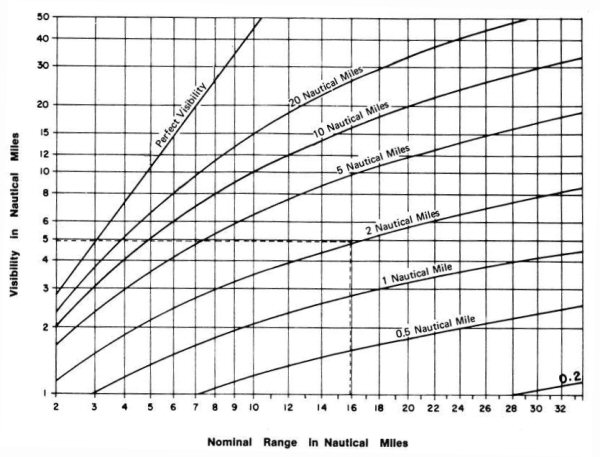
The light list in column 7 gives the nominal range of each lightstation optic where there is sufficient light to be seem 2 nautical miles or more when the meteorological visibility is 10 nautical miles.
When the mariner obtains the meteorological visibility from the weather report he can find the distance the light can be seem at night from the nominal range diagram.
Example: The light list gives the nominal range 16 nautical miles. The weather report gives the meteorological visibility 2 nautical miles. The point on the bottom of the diagram marked 16 is followed upwards until it intersects the curve marked 2 nautical miles. Follow that height horizontally to the left margin to find that the visibility of the light is 5 nautical miles.
Caution: The nominal range diagram is correct when the meteorological visibility is the same in the whole of the distance between the ship and the lighthouse. Conditions occur when this may not be true.
NOMOGRAM
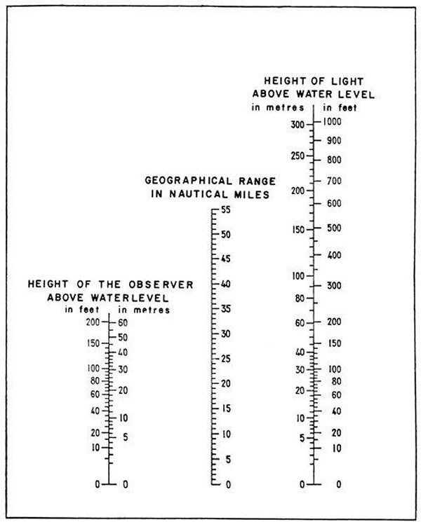
By using the above Nomogram a geographical range can be determined by placing a straightedge against the height of the respective light and the height of the observer above water level.
CANADA
AIDS TO NAVIGATION PROTECTION REGULATIONS
CANADA SHIPPING ACT, 2001
PART 5, SECTION 129
Obligation to report damage
129. (1) If a vessel, or anything towed by a vessel, runs down, moves, damages or destroys an aid to navigation in Canadian waters, the person in charge of the vessel shall, without delay, make a report to a marine communications and traffic services officer or, if that is not feasible, to an officer of the Canadian Coast Guard.
Obligation to report - navigation hazard
(2) A person in charge of a vessel in Canadian waters who discovers an uncharted hazard to navigation, or discovers that an aid to navigation is missing, out of position or malfunctioning, shall make a report without delay to a marine communications and traffic services officer or, if that is not feasible, to an officer of the Canadian Coast Guard.
Reference: http://laws-lois.justice.gc.ca/eng/acts/C-10.15/page-38.html#h-72
Criminal Code
Section 439 of the Criminal Code of Canada provides:
439. (1) Everyone who makes fast a vessel or boat to a signal, buoy or other seamark that is used for purposes of navigation is guilty of an offence punishable on summary conviction.
.(2) Everyone who wilfully alters, removes or conceals a signal, buoy or other seamark that is used for purposes of navigation is guilty of an indictable offence and liable for imprisonment for a term not exceeding ten years.
Reference: http://laws-lois.justice.gc.ca/eng/acts/C-46/page-202.html
Authority: Justice Laws Canada
Transport Canada
Canadian Coast Guard
Canada Shipping Act, 2001
http://laws-lois.justice.gc.ca/eng/acts/C-10.15/FullText.html
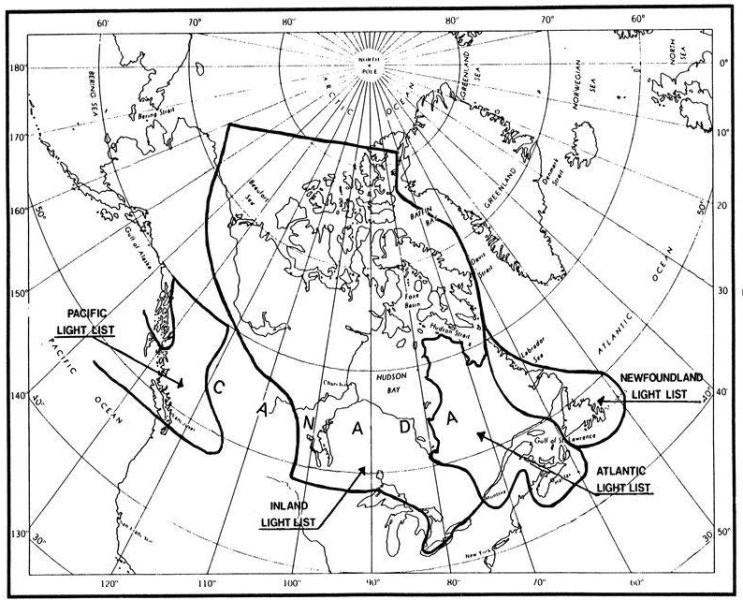
LIMITS OF LIGHT LISTS
CANADIAN COAST GUARD AIDS TO NAVIGATION OFFICES
| OFFICE | ADDRESS | JURISDICTION |
|---|---|---|
| ATLANTIC REGION: | ||
| St. John’s. | Supervisor Operations, Aids to Navigation, P.O. Box 5667, St. John's, NL, A1C 5X1, Tel.:1 (709) 772-6131 (E). |
Province of Newfoundland and Labrador |
| Maritime Provinces NS, PEI, NB |
Supervisor Operations, Aids to Navigation, P.O. Box 1236, Charlottetown, PEI, C1A 7M8, Tel.: 1 (902) 566-7936 (B). |
PEI, East Coast of NB to Québec Border, on Southeastern shore of Nova Scotia from Liscomb East, Cape Breton and North shore of Nova Scotia in Northumberland Strait From Cape Sable, NS to Cape St. Lawrence, Bras D'Or Lake, Strait of Canso, North of Causeway, St. Paul and Sable Island, NS Coastal Waters of the Bay of Fundy from the International Maine Boundary to Cape Sable, NS, Saint John River System |
| St. John’s. |
Superintendent, Aids to Navigation, P.O. BOX 5667, St. John's, NL, A1C 5X1, Tel.:1 (709) 772-2800 (B). |
|
| Navigational Warnings. |
Tel.: 1 (709) 695-2168 (B), 1-800-563-9089 (B) (TF), 1 (902) 564-7751 (B), 1-800-686-8676 (B) (TF), Email: NAVWARN.MCTSPortAuxBasques@innav.gc.ca, NAVWARN.MCTSSydney@innav.gc.ca |
|
| CENTRAL AND ARCTIC REGION: | ||
| Montréal, QC. |
CGG Regional headquarters Central and Arctic Region 105, rue McGill, 5th floor, Montreal, QC H2Y 2E7, Fax : 1 (514) 283-0056. |
Gulf and River St. Lawrence on the North and South shores from Grondines to Labrador Border and from, Pointe Langlois to New Brunswick Border, Inland Waters that drain into River and Gulf, Hudson Bay and Strait. |
| Operations Centre. |
Tel.: 1 (514) 283-1753 (B), 1-855-209-1976 (B) (H/N) (TF), Email: XCA-MontrealOps@dfo-mpo.gc.ca. |
|
| Québec, QC. |
Superintendent, Aids to Navigation and Waterways, 1550, Avenue D'Estimauville, Québec, QC, G1J 5E9, Tel.: 1 (418) 648-3574 (B) |
|
| SAINT-LAURENT SECTOR | ||
| Québec, QC. |
Supervisor, Aids to Navigation, 1550, Avenue D'Estimauville, Québec, QC, G1J 5E9, Tel.: 1 (418) 648-3574 (B), Fax : 1 (418) 649-6690 (B), Email : aidesnavquebec@dfo-mpo.gc.ca. |
St. Lawrence River from Beauharnois to Grondines, Richelieu River to US Border, Ottawa River to Ottawa, Inland Waters that drain into St. Lawrence, Ottawa and Richelieu Rivers. |
| Alert Network: |
Tel.: 1 (418) 648-4366 (B) (N/H), 1-800-363-4735 (B) (N/H) (TF). |
|
| GREAT LAKES SECTOR | ||
| Navigational Warnings. |
Tel : 1 (613) 925-0666 (B). Email: NAVWARN.MCTSPrescott@innav.gc.ca |
|
| Parry Sound, ON. |
Supervisor, Aids to Navigation, 28 rue Waubeek, Parry Sound, ON, P2A 1B9, Tel.: 1 (705) 773-4322 (E). |
|
| WESTERN REGION: | ||
| Victoria, BC. |
Superintendent, Aids to Navigation and Waterways, 25, rue Huron, Victoria, BC, V8V 4V9, Tel.: 1 (250) 480-2600 (E), 1-800-667-2179 (T/F). |
From the North International Boundary to the South International Boundary, including Inland Waters of British Columbia and the Yukon From International Boundary on the South to Cape Caution, Vancouver Island, Inland Waters of British Columbia. |
| Email : | CGBaseVICMNS@pac.dfo-mpo.gc.ca | |
| Navigational Warnings. |
Tel : 1 (250) 627-3070 (E). Email: NAVWARN.MCTSPrinceRupert@innav.gc.ca |
|
________________________________________
(B) Service is available in French and English
(A) Service is available in English only
(TF) Toll Free
(N/H) Nights and Holidays
Report a problem on this page
- Date modified: