
5CNational Marine Conservation Areas
1.National Marine Conservation Areas in Eastern Canada
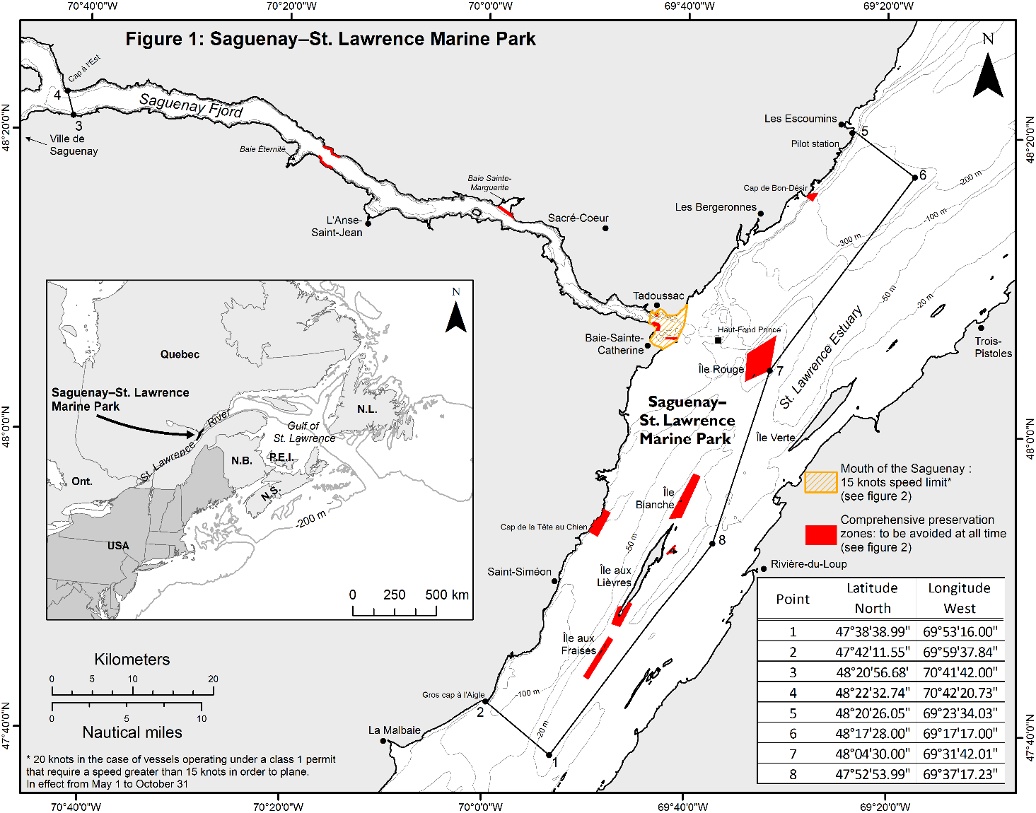
1.1The Saguenay-St. Lawrence Marine Park, Quebec
The Saguenay-St. Lawrence Marine Park exists by virtue of two acts, one from the Government of Canada and the other from the Government of Quebec (Saguenay-St. Lawrence Marine Park Act, S.C. 1997, c. 37 and Loi sur le parc marin du Saguenay-Saint-Laurent, R.S.Q, c. P-8.1). The Marine Park includes the Saguenay Fjord, downstream from Cap à l’Est, and the northern portion of the St. Lawrence Estuary between Gros Cap à l’Aigle upstream to Les Escoumins downstream (Figure 1). The Marine Park covers approximately 1,245 km2, includes the water column and seabed, and extends to the normal high-tide line. It protects representative portions of St. Lawrence Estuary and Saguenay Fjord ecosystems.
The Marine Park and surrounding waters are well known for the resident St. Lawrence beluga whale population and the wide diversity of marine mammals that migrate here, mainly to feed, between the months of April and November. Whales involved in feeding behaviour may suddenly surface unexpectedly. Heightened awareness on the mariner’s part is necessary to prevent collisions with whales.
Oceanographic conditions in the area produce very strong currents and periodical fog in summer. The presence of numerous ports and marinas, as well as an important whale-watching industry, generates intense navigational activity, particularly between Tadoussac and Les Escoumins.
Marine Mammal Protection
A.Marine Activities in the Saguenay–St. Lawrence Marine Park Regulations
Marine Activities in the Saguenay–St. Lawrence Marine Park Regulations (SOR/2002-76) regulate activities at sea, notably whale watching. One of their main objectives is to reduce the impact of navigation on marine mammals. The regulations indicate the maximum navigation speed permitted throughout the park, as well as the distances and speeds to be respected when whales are present. These distances vary depending on the risk status of a given species.
The main prescribed behaviours include:
1.General prohibitions
No person shall engage in behaviour that may disturb, kill or injure a marine mammal. Any collision with a marine mammal must immediately be reported to a park warden by dialling 1-866-508-9888.
2.Distance requirements
A minimum distance of 400 meters from all marine mammals
endangered or at risk (blue whale, North Atlantic right whale and
beluga whale) must be respected.
No person shall approach within 200 meters of any other
whale species.
3.Speed limits
The maximum navigational speed within the Marine Park is 25 knots.
From May 1st to Oct 31st, it is
prohibited for a vessel’s pilot to navigate at a speed greater
than 15 knots in the mouth of the Saguenay, whose limits
are defined in Figures 1 and 2.
If a vessel unexpectedly encounters a threatened or endangered
whale species (ex. blue whale) at less than 400 meters,
the captain must reduce the speed of the vessel to a speed no
greater than the minimum speed required to maneuver the vessel
and move away to a distance greater than 400 meters.
A permit is required to operate a marine tour business, to carry out scientific activities and for film productions.
For more information on the Regulations, consult the Saguenay-St. Lawrence Marine Park website.
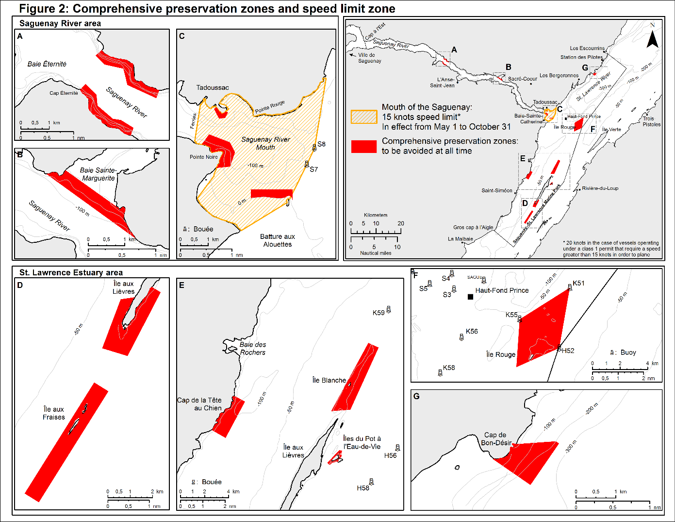
B.Zoning
The zoning of the Marine Park is designed to protect specific habitats and the species that live within them while promoting ecologically sustainable use of the Marine Park and quality visitor experiences. Comprehensive preservation zones were created to protect especially sensitive habitat (Figure 2). These zones cover 3% of the Marine Park’s surface area and include sectors that are particularly important to marine mammals and seabirds caring for their young and for resting. All mariners are requested to avoid these zones.
C.Marine Mammal Emergencies
To report a marine mammal that is either in trouble or dead, call 1-877-722-5346.
Information
For questions concerning the Saguenay–St. Lawrence Marine Park, contact Parks Canada at 418-235-4703 or saguenay@pc.gc.ca, or visit Saguenay-St. Lawrence Marine Park website.
For general information regarding Parks Canada's National Marine Conservation Areas, National Parks or National Historic Sites, please contact our National Information Service at 1-888-773-8888 or information@pc.gc.ca, or visit the Parks Canada website.
2.National Marine Conservation Areas in the Great Lakes
2.1Fathom Five National Marine Park, Ontario
Fathom Five National Marine Park is a 114 km2 protected area located on Lake Huron near Tobermory, Ontario. Most of the islands within the park are protected under the Canada National Parks Act (S.C. 2000, c. 32) and the waters are managed in the "spirit" of the Canada National Marine Conservation Areas Act (S.C. 2002, c. 18) using a variety of provincial and federal legislation.
Fathom Five National Marine Park was first established in 1972 as a provincial park and later in 1987 became the first site to be under the stewardship of Parks Canada's National Marine Conservation Area program. It is situated along the edge of the Niagara Escarpment, which descends 165 m into the clear waters of Lake Huron and periodically emerges as an archipelago of 21 islands, smaller islets, reefs and shoals between the Saugeen (Bruce) Peninsula and Manitoulin Island. The park is renowned for its 22 shipwrecks which are one of the most representative collections of historic vessels in the Great Lakes and provide outstanding diving opportunities.
Weather can be unpredictable in Fathom Five National Marine Park with strong winds and currents, and there is high vessel traffic in the Tobermory Harbours due to a passenger ferry service, commercial tour boats, commercial dive charters, and recreational vessels operating in the area.
Coordinates
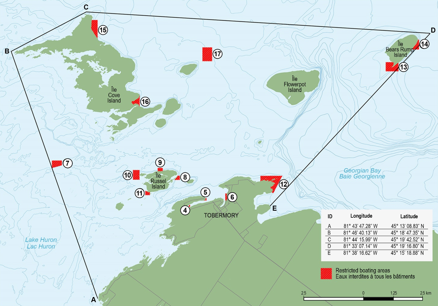
Map showing the boundaries of Fathom Five National Marine Park
and 14 restricted boating areas described in the Vessel
Operation Restriction Regulations (SOR/2022-175;
Schedule 1, Part 2, Items 4 to
17).
Restricted Areas
Parks Canada manages 14 restricted navigation zones in Fathom Five National Marine Park through a delegation of authority from Transport Canada. These areas are described in the Vessel Operation Restriction Regulations (SOR/2022-175; Schedule 1, Part 2, Items 4 to 17) and are indicated on the map above. All motorized and non-motorized vessels require a permit to enter the restricted areas, and vessel operators must comply with conditions set out in the permit to ensure safe and efficient navigation, minimize risk to the safety of persons, and protect the public interest and the environment within the area. Additional restrictions apply to the restricted areas in the Tobermory Harbours, including but not limited to:
(a)Motorized commercial or recreational vessels are not
permitted to enter the restricted areas described as Item 5
associated with Big Tub Lighthouse; and,
(b)Motorized recreational vessels are not permitted to
enter the restricted area described as Item 4 associated with
the Sweepstakes and City of Grand Rapids
shipwrecks, except for property owners adjacent to the
restricted area. All other vessels must adhere to an access
schedule and other vessel-specific conditions outlined in the
permit.
In accordance with the Vessel Operation Restriction Regulations (SOR/2022-175; Schedule 6, Part 2, Item 29 under “Georgian Bay Area”), a speed limit of 10kph is also in effect throughout Big Tub Harbour from the shore to a line connecting points at coordinates 45°15′29″ 81°40′21″ and 45°15′29″ 81°40′02″.
Mooring Locations
Moorings are maintained within many of the restricted boating areas to facilitate diving and protect the historic shipwrecks. Mooring locations may vary on an annual basis but coordinates for the 2026 season are listed in the table below.
|
Shipwreck Name |
Easting |
Northing |
Latitude |
Longitude |
|
Arabia |
447220 |
5017855 |
45° 18' 43.3800'' N |
81° 40' 23.6352'' W |
|
447220 |
5017775 |
45° 18' 41.0112'' N |
81° 40' 23.6820'' W |
|
|
Charles P. Minch |
444281 |
5015922 |
45° 17' 40.1352'' N |
81° 42' 37.7172'' W |
|
444543 |
5015795 |
45° 17' 36.5424'' N |
81° 42' 26.2224'' W |
|
|
Dunk’s Point |
450362 |
5012779 |
45° 16' 00.3468'' N |
81° 37' 57.8748'' W |
|
450441 |
5012264 |
45° 15' 43.6536'' N |
81° 37' 54.0696'' W |
|
|
Forest City |
456178 |
5018358 |
45° 19' 02.6400'' N |
81° 33' 32.7600'' W |
|
456206 |
5018319 |
45° 19' 01.2400" N |
81° 33' 31.4800" W |
|
|
John Walters |
444840 |
5012060 |
45° 15' 34.9416'' N |
81° 42' 14.8680'' W |
|
James C. King |
444389 |
5012931 |
45° 16' 03.6300'' N |
81° 42' 31.5720'' W |
|
444323 |
5012906 |
45° 16' 03.0576'' N |
81° 42' 34.4772'' W |
|
|
Newaygo |
441074 |
5013316 |
45° 16' 14.8800'' N |
81° 45' 03.8844'' W |
|
441058 |
5013253 |
45° 16' 13.3068'' N |
81° 45' 04.3740'' W |
|
|
440978 |
5013114 |
45° 16' 08.6808'' N |
81° 45' 09.1620'' W |
|
|
Philo Scoville |
445300 |
5013057 |
45° 16' 07.6404'' N |
81° 41' 49.8012'' W |
|
Sweepstakes |
446607 |
5011556 |
45° 15' 19.7964'' N |
81° 40' 49.5048'' W |
|
446617 |
5011536 |
45° 15' 19.1772'' N |
81° 40' 49.0224'' W |
|
|
Truellen |
444992 |
5015115 |
45° 17' 14.4528'' N |
81° 42' 04.6188'' W |
|
The Tugs |
448066 |
5011973 |
45° 15' 34.1424'' N |
81° 39' 42.6492'' W |
|
W.L. Wetmore |
444297 |
5012669 |
45° 15' 55.3428'' N |
81° 42' 36.5184'' W |
|
444364 |
5012641 |
45° 15' 55.0044'' N |
81° 42' 33.7716'' W |
Note:
Easting and Northing coordinates are Universal Transverse
Mercator Projection Zone 17 North.
All projected and geographic coordinates are North American
Datum 1983.
Permitting Requirements
•An access permit is required to enter the restricted boating areas in Fathom Five National Marine Park, although some vessel types may not be permitted to access the restricted area associated with the Sweepstakes and City of Grand Rapids shipwrecks in Big Tub Harbour.
•A dive permit is required to scuba dive in Fathom Five National Marine Park., All divers must also register and participate in an orientation program prior to obtaining a permit.
Both permits are available at the Parks Canada Visitor Centre in Tobermory, Ontario.
Information
For questions concerning Fathom Five National Marine Park, contact Parks Canada at 519-596-2233 or bruce-fathomfive@pc.gc.ca, or visit Fathom Five National Marine Park.
For general information regarding Parks Canada's National Marine Conservation Areas, National Parks or National Historic Sites, please contact our National Information Service at 1-888-773-8888 or information@pc.gc.ca, or visit the Parks Canada website.
3.National Marine Conservation Areas in Western Canada
3.1Gwaii Haanas National Park Reserve, National Marine Conservation Area Reserve, and Haida Heritage Site, British Columbia
Gwaii Haanas is a 5000 km2 land-and-sea protected area located in Haida Gwaii, British Columbia (Figure 1). The area is cooperatively managed by the Council of the Haida Nation and Government of Canada through the Archipelago Management Board upholding guiding principles based on ethics and values of Haida law: respect, responsibility, interconnectedness, balance, seeking wise council. and giving and receiving. The terrestrial portion is protected under the Canada National Parks Act (S.C. 2000, c. 32) and the adjacent marine area is protected under the Canada National Marine Conservation Areas Act (S.C. 2002, c. 18). The entire area is protected as a Haida Heritage Site by the Council of the Haida Nation.
Gwaii Haanas National Marine Conservation Area (NMCA) Reserve is one of the first NMCAs established in Canada. NMCAs are intended to protect and conserve representative marine areas for the benefit, education and enjoyment of the people of Canada and the world.
Coordinates
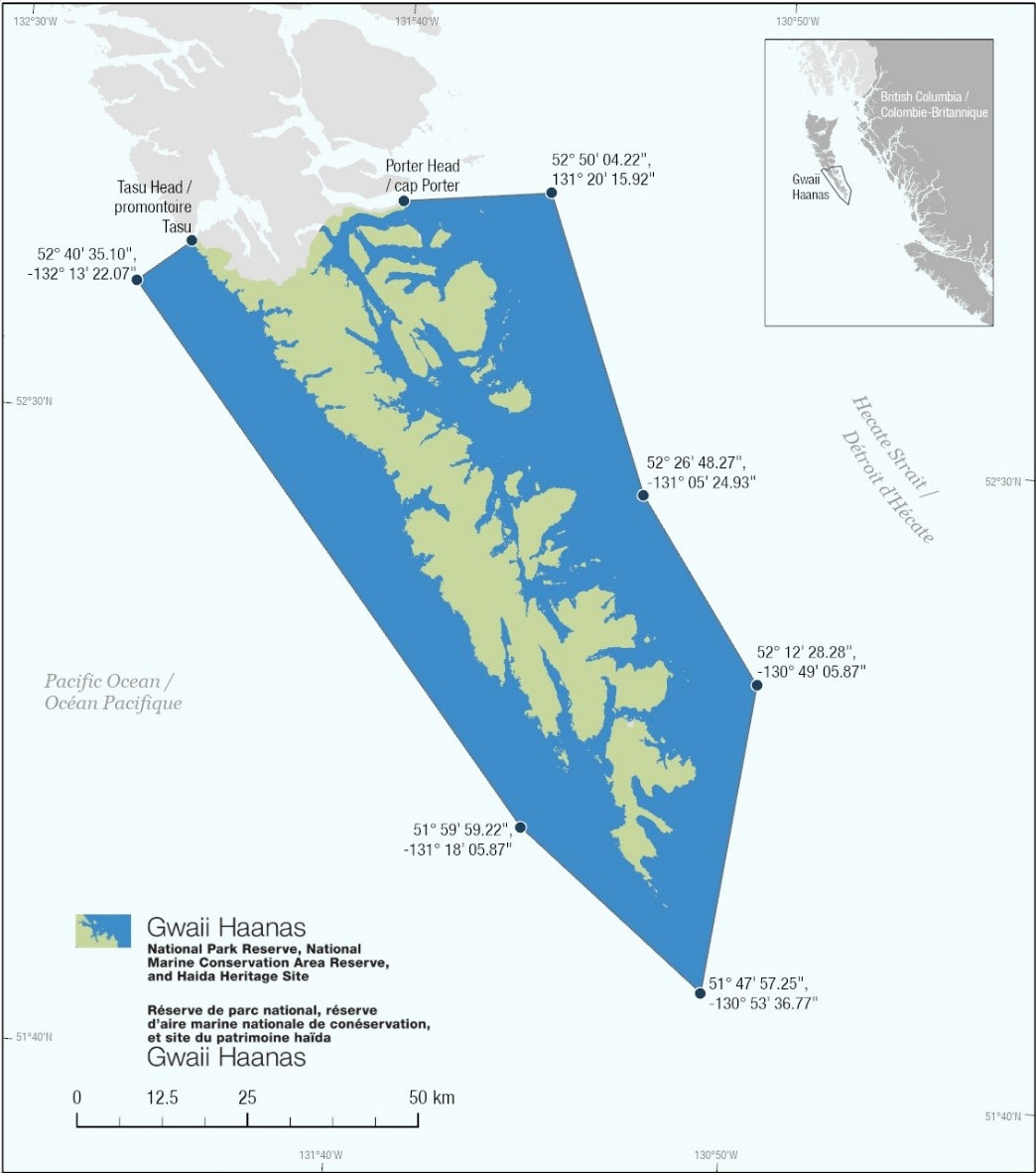
Figure 1: Gwaii Haanas National Park Reserve, National Marine
Conservation Area Reserve, and Haida Heritage site.
Note: Latitude and longitude coordinates are expressed using
the North American Datum of 1983.
Zoning
Following an extensive consultation process, the Gwaii Haanas Gina ‘Waadlux̱an KilG̱uhlG̱a Land-Sea-People Management Plan 2018 – an integrated land and sea management plan for Gwaii Haanas was approved in November 2018. The zoning plan (Figure 2) was implemented on May 1, 2019. Marine strict protection zones protect ecological and cultural features while minimizing socio-economic impacts. See the Fishery Notice webpage for detailed geographic descriptions and section 7.0 of the management for permitted activities within marine strict protection zones.
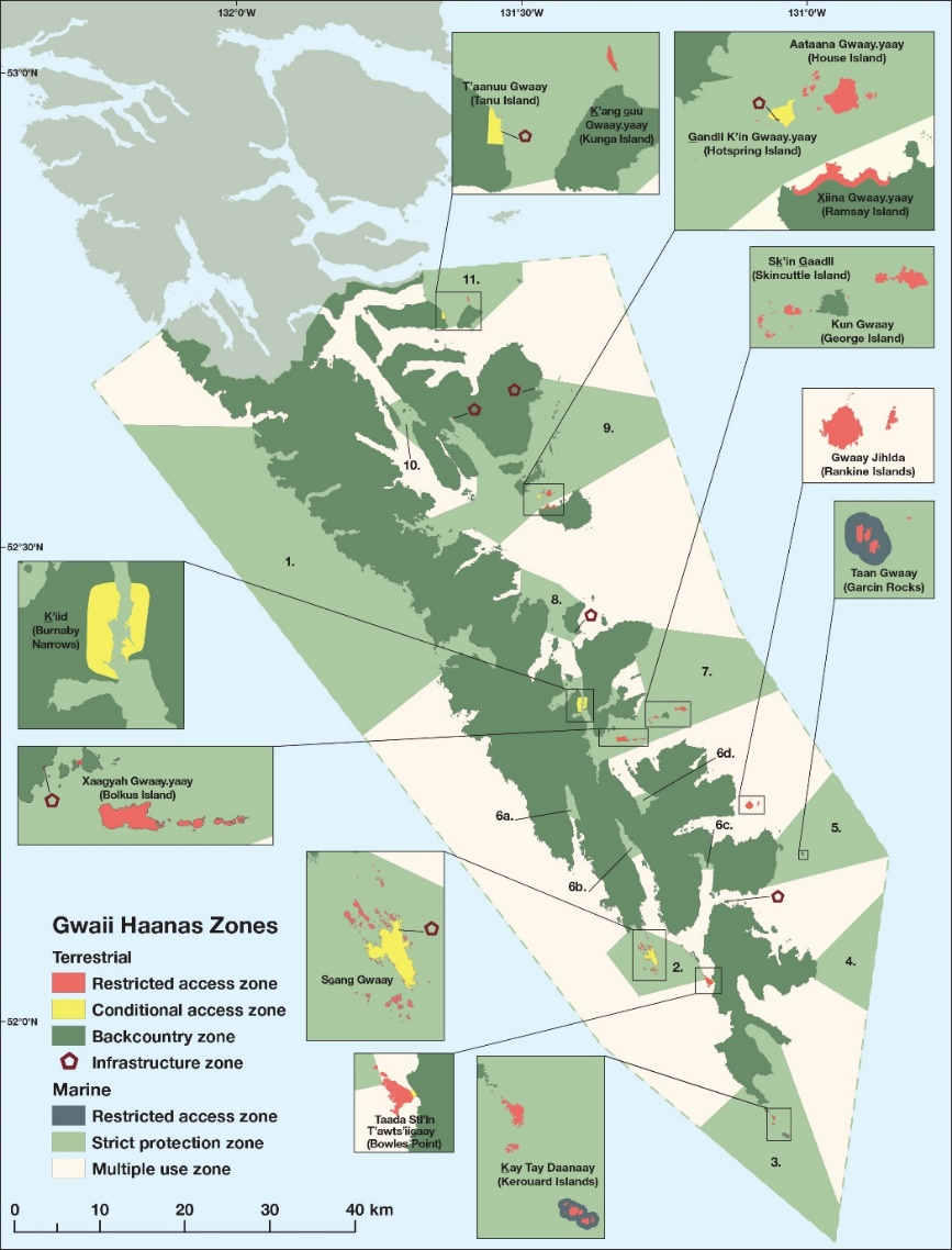
Figure 2: Terrestrial and marine zoning plan map from the Gwaii Haanas Gina ‘Waadlux̱an KilG̱uhlG̱a Land-Sea-People Management Plan 2018
Visiting Haida Gwaii Watchmen Sites and Permitting Requirements
Those who would like to visit Gwaii Haanas must make a reservation in advance and obtain a permit at the Gwaii Haanas office in Skidegate or by calling 1-877-559-8818. Independent visitors are also required to participate in an orientation prior to entering the area. Visitors choosing to visit with a licensed tour operator will receive their orientation via their guides. These requirements do not apply to people of Haida ancestry.
Visitors are welcome at the Haida Gwaii Watchmen Sites at Ḵ’uuna Llnagaay (Skedans), T’aanuu Llnagaay (Tanu), Hlk’yah GawG̱a (Windy Bay), Gandll K'in Gwaay.yaay (Hotspring Island), and SG̱ang Gwaay (Anthony Island). Haida citizens are at each of the sites between May and September to safeguard these places of living Haida culture. Watchmen sites can be visited between 9:00 am and 6:00 pm. The Watchmen are on call seven days a week and need their downtime in the evenings. Visitors are encouraged to plan travel days to end before 4:00 pm, so they have plenty of time to experience the site before 6:00 pm close. All visitors must contact the on-site Haida Gwaii Watchmen by radio (marine channel 6) before coming ashore. No more than 12 visitors are permitted ashore at one time.
Restrictions
•Commercial and recreational extraction of all types (e.g., fishing, plant harvesting) are prohibited within the marine strict protection zones (see the Fisheries and Oceans Canada website Fishery Notice for detailed geographic descriptions).
•Removal of any items from above the high tide line in Gwaii Haanas (i.e, within the Gwaii Haanas terrestrial area) is strictly prohibited.
•The Huxley Island Operations Station is closed until further notice to protect the public from hazards associated with a landslide at this facility. Although a land-based closure, for safety reasons it is important that mariners do not approach the site. For a map of the location and current status of this closure please refer to Important Bulletins on the Gwaii Haanas website.
Information
For questions concerning Gwaii Haanas National Park Reserve,
National Marine Conservation Area Reserve, and Haida Heritage
Site, contact Parks Canada at 1-877-559-8818 or gwaiihaanas@pc.gc.ca, or visit
the Gwaii Haanas
website.
For general information regarding Parks Canada's National
Marine Conservation Areas, National Parks or National Historic
Sites, please contact our National Information Service at
1-888-773-8888 or
information
@pc.gc.ca, or visit the
Parks Canada website.
Authority: Council of the Haida Nation and Parks Canada Agency
Report a problem on this page
- Date modified: