
Archived information
The Standard on Web Usability replaces this content. This content is archived because Common Look and Feel 2.0 Standards have been rescinded.
Archived information is provided for reference, research or recordkeeping purposes. It is not subject to the Government of Canada Web Standards and has not been altered or updated since it was archived.
NOTICES TO MARINERS
PUBLICATION
WESTERN EDITION
July 31, 2020

Safety First, Service Always
Published Monthly by the
CANADIAN COAST GUARD
www.notmar.gc.ca/subscribe/
CONTENTS
| Section 1 | General and Safety Information |
| Section 2 | Chart Corrections |
| Section 3 | Radio Aids to Marine Navigation Corrections |
| Section 4 | Sailing Directions and Small Craft Guide Corrections |
| Section 5 | List of Lights, Buoys and Fog Signals Corrections |
Canadian Coast Guard Programs
Aids to Navigation and Waterways
Fisheries and Oceans Canada
Montreal, Quebec
H2Y 2E7
© Her Majesty the Queen in Right of Canada, 2020
Fs152-6E-PDF
ISSN 1719-7708
Disponible en français :
Publication des Avis aux navigateurs
Édition de l'Ouest
Édition mensuelle Nº07/2020
Fisheries and Oceans Canada
Official Publication of the Canadian Coast Guard
EXPLANATORY NOTES
Geographical positions refer directly to the graduations of the largest scale Canadian Hydrographic Service chart unless otherwise indicated.
Bearings refer to the true compass and are measured clockwise from 000° (North) clockwise to 359°; those relating to lights are from seaward.
Visibility of lights is that in clear weather.
Depths - The units used for soundings (metres, fathoms or feet) are stated in the title of each chart.
Elevations are normally given above Higher High Water, Large Tide unless otherwise indicated.
Distances may be calculated as follows:
1 nautical mile = 1,852 metres (6,076.1 feet)
1 statute mile = 1,609.3 metres (5,280 feet)
1 metre = 3.28 feet
Temporary and Preliminary Notices to Mariners are indicated by a (T) or a (P) in Section 1, respectively. Please note that nautical charts are not amended by the Canadian Hydrographic Service for temporary (T) and preliminary (P) notices. It is recommended that mariners chart these corrections in pencil. For the list of charts affected by (T) & (P) notices, please refer to the index on page ii of the current Monthly Summary of (T) and (P) Notices publication.
Please note that, in addition to the temporary and preliminary changes normally advertised as (T) & (P) notices, there are a few permanent changes to aids to navigation that have been advertised as preliminary Notices to Mariners while charts are being updated for new editions.
Marine Information Report & Suggestion Sheet
Mariners are requested to notify the responsible authorities when new or suspected dangers to navigation are discovered, changes observed in aids to navigation or corrections to publications are seen
to be necessary. Such communications can be made using the Marine Information Report & Suggestion Sheet inserted on the last
page of each monthly edition of Notices to Mariners.
Canadian Hydrographic Service (CHS) - Information Published in Section 2 of Notices to Mariners
Mariners are advised that only the most critical changes that directly affect safety to navigation are issued in Section 2 – Chart Corrections. This limitation
is required to ensure that charts remain as clear and easy to read as possible. As a result, mariners may see minor discrepancies of a
non-critical nature between information in official publications. For example, a small change in the nominal range or focal height of a light
may not result in the production of a chart correction in Notices to Mariners, but may result in a correction in the List of Lights, Buoys and
Fog Signals publication.
In the case of a discrepancy between information provided on CHS charts relating to aids to navigation, and the List of Lights, Buoys and Fog Signals publication, the latter shall be deemed as containing the most up-to-date information.
Canadian Nautical Charts & Publications
A source list of Canadian nautical charts and publications is published in Notice No. 14 of the Notices to Mariners Annual Edition 2020. The source supply and the prices
effective at the time of printing are listed. For current chart edition dates, please refer to the following website:
www.chs-shc.gc.ca/charts-cartes/paper-papier/index-eng.asp
CHART CORRECTIONS - SECTION 2
Corrections to nautical charts will be listed in numerical order by chart number. Each chart correction listed applies only to that particular chart. Related charts, if any, will have their own specific correction listed separately.
Users should also refer to CHS Chart 1: Symbols, Abbreviations and Terms for additional information pertaining to the correction of charts.
The illustration below describes the elements that will comprise a typical Section 2 chart correction:

The last correction number is identified with the LNM/D or Last Notice to Mariners Number / Date.
NOTICES TO MARINERS WEBSITE – MONTHLY EDITIONS, CHART CORRECTIONS, AND CHART PATCHES
The Notices to Mariners website allows users to access the monthly publications,
chart corrections, and chart patches.
Users can subscribe for free to the email notification service
to receive notifications when charts of interest are updated, including their patches, as well as when a new monthly edition becomes available online.
In addition, the monthly publication and related files to download, such as chart patches and Sailing Directions diagrams, can be obtained all together through the download of a single ZIP file.
ADVISORY NAVIGATIONAL WARNINGS / NOTICES TO SHIPPING
The Canadian Coast Guard is implementing a number of changes to the aids to navigation system in Canada.
These changes are advertised as Navigational Warnings, formerly called Notices to ShippingFootnote 1, that are broadcast by the Canadian Coast Guard, and are then followed up with Notices to Mariners, then charts are updated by hand correction, reprints or new editions.
Mariners are advised that all relevant Navigational Warnings (NAVWARNs) should be kept until superseded by Notices to Mariners or through revised charts issued by the Canadian Hydrographic Service (CHS).
Navigational Warnings are accessible on the applicable regional page on the Canadian Coast Guard e-Navigation Maritime Information Portal at http://www.marinfo.gc.ca/e-nav.
The Canadian Hydrographic Service is reviewing the impact of these changes with the Canadian Coast Guard and together are preparing an action plan on the issuing of chart revisions.
For further information, contact your regional Navigational Warning (NAVWARN) Issuing Desk.
Western Region
Prince Rupert MCTS Centre
Canadian Coast Guard
Bag 4444
Prince Rupert, BC V8J 4K2
Telephone: (250) 627-3070
Email: NAVWARN.MCTSPrinceRupert@innav.gc.ca
Website: http://www.marinfo.gc.ca/e-nav
Arctic Region
* Iqaluit MCTS Centre
Operational from approximately mid-May until late December.
Canadian Coast Guard
P.O. Box 189
Iqaluit, NU X0A 0H0
“A” Series
Telephone: (867) 979-5269
“H” Series
Telephone: (867) 979-0310
Facsimile: (867) 979-4264
Email: NAVWARN.MCTSIqaluit@innav.gc.ca
Website: http://www.marinfo.gc.ca/e-nav
* Service available in English and French.
Index
NUMERICAL INDEX OF CANADIAN CHARTS AFFECTED
This numerical index lists all nautical charts mentioned in this monthly edition of Notices to Mariners. Only charts appearing in Section 2 of this publication require a chart correction. The appearance of charts in all other sections, particularly those related to the correction of other nautical publications, is included here for reference.
| 2201 | 3462 | 3546 | 3986 |
| 3000 | 3463 | 3548 | 3987 |
| 3002 | 3479 | 3564 | 4459 |
| 3311 | 3494 | 3673 | 4728 |
| 3312 | 3495 | 3679 | 5143 |
| 3313 | 3496 | 3685 | 5164 |
| 3441 | 3515 | 3947 | 5165 |
| 3443 | 3526 | 3958 | |
| 3447 | 3538 | 3964 | |
| 3461 | 3545 | 3978 |
SECTION 1 - GENERAL AND SAFETY INFORMATION
CANADIAN COAST GUARD PUBLICATION – COMMENTS AND SUGGESTIONS ON NOTICES TO MARINERS (NOTMAR) PUBLICATIONS
In an effort to continuously improve the Notices to Mariners publications and to provide the most efficient service possible, the Notices to Mariners team invites all mariners and other interested parties to submit comments and suggestions on possible improvements to its various publications and services at the following email address: Notmar.XNCR@dfo-mpo.gc.ca
CANADIAN HYDROGRAPHIC SERVICE – MODIFICATIONS TO THE 2020 CANADIAN TIDE AND CURRENT TABLES VOLUME 5 – JUAN DE FUCA STRAIT AND STRAIT OF GEORGIA
(Recurrent publication of notice *204/20, originally published in the Notices to Mariners Publication - Western Edition 02/2020.)
The Canadian Hydrographic Service of the Pacific Region has recently been informed of an error in the 2020 Canadian Tide and Current Tables, Volume 5 - Juan de Fuca Strait and Strait of Georgia, page 123, Table 2, Index no. 7120 – VICTORIA.
Mariners should replace the values for Victoria, Index no. 7120 using the attached Table 2 for page 123:
https://www.notmar.gc.ca/publications/monthly-mensuel/images/ed022020-part1-vol5-p123.pdf
TRANSPORT CANADA – COVID-19 MEASURES, UPDATES AND GUIDANCE
(Recurrent publication of notice *401/20, originally published in the Notices to Mariners Publication - Western Edition 04/2020.)
Please refer to the link below for the latest updates to transportation related measures taken by Transport Canada in response to the evolving novel Coronavirus disease (COVID-19):
https://www.tc.gc.ca/en/initiatives/covid-19-measures-updates-guidance-tc.html
For travel advice and all other updates, please visit: Canada.ca/coronavirus
ANGUNIAQVIA NIQIQYUAM MARINE PROTECTED AREA (ANMPA) AND TARIUM NIRYUTAIT MARINE PROTECTED AREAS (TNMPA) – BELUGA AND BOWHEAD WHALE PROTECTION: VOLUNTARY AVOIDANCE AND SLOWDOWN AREAS
(Recurrent publication of notice *505/20, originally published in the Notices to Mariners Publication - Western Edition 05/2020.)

The two established Marine Protected Areas (MPAs) in Canada’s Western Arctic are located within the Inuvialuit Settlement Region, as such all activities must comply with the Inuvialuit Final Agreement. Protection and preservation of Arctic wildlife, the environment and biological productivity is one of the principles of the Inuvialuit Final Agreement and it is this principle that led the Inuvialuit Regional Corporation and the Inuvialuit Game Council to initiate establishment of the Western Arctic MPAs. The waters in and near the MPAs, and the offshore marine habitats of the Beaufort Sea and Amundsen Gulf, are important summer foraging habitats used seasonally (May-October) by the Eastern Beaufort Sea beluga stock, and the Bering-Chukchi-Beaufort bowhead population.
REGULATORY PROTECTION MEASURES
All whale species are protected under the Marine Mammal Regulations, pursuant to the Fisheries Act. Within the boundaries of the MPAs, a general prohibition is set out in the Regulations, pursuant to the Oceans Act. Any incident with a marine mammal within the MPAs must be reported within two hours after its occurrence, to the Canadian Coast Guard. For marine wildlife sightings and incidents such as collisions that occur outside the MPAs or for any situation involving a marine mammal that is dead or in trouble, contact Fisheries and Oceans Canada, Inuvik office at (867) 777-7500.
For more information on the ANMPA and TNMPA, including local
contacts and species specific minimum distances, see Section
A2 - Notices 5 and 5A.3 of the Notices to Mariners Annual
Edition 2020.
VOLUNTARY PROTECTION MEASURES
Voluntary measures are in effect from June 1st to October 31st, 2020. See map above.
These measures apply to merchant vessels, cruise ships, small vessels and adventure craft within the boundaries of the MPAs and the additional identified areas to prevent collisions with whales and to mitigate the underwater noise generated by the vessels. These measures should only be taken when they will not jeopardize navigational safety.
Avoid (red area): To reduce the risk of underwater noise disturbance and collisions with whales within the MPAs, vessels should avoid transiting through the MPAs if possible. If passage through this area is required, vessels should slow down to a maximum speed through the water of 10 knots and post a lookout such as a marine mammal observer in order to increase the chances of seeing the whales and thus taking necessary measures to avoid them. If bypassing the whales is not possible, slow down and wait for the animals to move away to a distance greater than 400 metres (0.215 nautical miles) before resuming original speed up to 10 knots. It is more difficult to see the animals in rain, fog, or in rough sea states, therefore increased caution is recommended.
Slow down to 10 knots or less (yellow area): To reduce the risk of underwater noise disturbance and collisions with whales within this area, it is recommended that vessels should slow down to a maximum speed through the water of 10 knots, remain in the navigation and marked community supply channels and post a lookout.
These voluntary measures are secondary to rights under the Inuvialuit Final Agreement.
MPA Coordinates
The Tarium Niryutait Marine Protected Areas consist of three areas of the Mackenzie Bay: Okeevik, Kittigaryuit and Niaqunnaq. The three areas are bounded by rhumb lines connecting the following geographical coordinates [North America Datum 1983 (NAD 83)/World Geodetic System (WGS 84)].
Okeevik Sub Area
|
Point |
Latitude (North) |
Longitude (West) |
|
1 |
69° 38’ 19” |
135° 25’ 09” |
|
2 |
69° 38’ 03” |
135° 25’ 11” |
|
3 |
69° 37’ 46” |
135° 24’ 52” |
|
4 |
69° 29’ 49” |
135° 12’ 49” |
|
5 |
69° 30’ 45” |
135° 16’ 56” |
|
6 |
69° 29’ 26” |
135° 18’ 53” |
|
7 |
69° 29’ 23” |
135° 19’ 06” |
|
8 |
69° 28’ 07” |
135° 20’ 25” |
|
9 |
69° 27’ 36” |
135° 24’ 25” |
|
10 |
69° 25' 51” |
135° 32’ 27” |
|
11 |
69° 26’ 32” |
135° 34’ 54” |
|
12 |
69° 28’ 21” |
135° 35’ 24” |
|
13 |
69° 28’ 35” |
135° 36’ 40” |
|
14 |
69° 28’ 39” |
135° 37’ 58” |
|
15 |
69° 30’ 34” |
135° 45’ 54” |
|
16 |
69° 35’ 18” |
135° 35’ 42” |
|
17 |
69° 36’ 00” |
135° 22’ 10” |
|
18 |
69° 34’ 40” |
135° 20’ 09” |
|
19 |
69° 34’ 00” |
135° 20’ 09” |
|
20 |
69° 34’ 00” |
135° 27’ 39” |
|
21 |
69° 36’ 00” |
135° 27’ 39” |
|
22 |
69° 27’ 00” |
135° 31’ 11” |
|
23 |
69° 27’ 00” |
135° 34’ 45” |
Kittigaryuit Sub Area
|
Point |
Latitude (North) |
Longitude (West) |
|
1 |
69° 35’ 10” |
133° 48’ 26” |
|
2 |
69° 34’ 00” |
133° 28’ 00” |
|
3 |
69° 23’ 37” |
133° 26’ 40” |
|
4 |
69° 20’ 34” |
133° 40’ 37” |
|
5 |
69° 19’ 05” |
133° 42’ 21” |
|
6 |
69° 19’ 01” |
133° 42’ 31” |
|
7 |
69° 20’ 39” |
133° 43’ 20” |
|
8 |
69° 16’ 42” |
133° 54’ 54” |
|
9 |
69° 15’ 20” |
134° 06’ 53” |
|
10 |
69° 16’ 33” |
134° 05’ 56” |
|
11 |
69° 20’ 42” |
134° 02’ 44” |
|
12 |
69° 24’ 00” |
133° 59’ 10” |
|
13 |
69° 24’ 34” |
133° 53’ 49” |
|
14 |
69° 28’ 21” |
133° 48’ 15” |
|
15 |
69° 28’ 02” |
133° 50’ 59” |
|
16 |
69° 33’ 20” |
133° 47’ 29” |
|
17 |
69° 34’ 33” |
133° 47’ 42” |
|
18 |
69° 32’ 55” |
133° 51’ 09” |
|
19 |
69° 32’ 56” |
133° 51’ 54” |
|
20 |
69° 33’ 46” |
133° 55’ 48” |
|
21 |
69° 33’ 46” |
133° 55’ 31” |
Niaqunnaq Sub Area
|
Point |
Latitude (North) |
Longitude (West) |
|
1 |
69° 08’ 00” |
136° 16’ 44” |
|
2 |
69° 04’ 25” |
136° 07’ 45” |
|
3 |
69° 03’ 43” |
136° 07’ 08” |
|
4 |
69° 01’ 19” |
136° 04’ 45” |
|
5 |
69° 01’ 14” |
136° 04’ 45” |
|
6 |
69° 00’ 57” |
136° 05’ 42” |
|
7 |
69° 00’ 12” |
136° 07’ 08” |
|
8 |
68° 57’ 00” |
136° 10’ 00” |
|
9 |
68° 55’ 00” |
136° 15’ 00” |
|
10 |
68° 54’ 22” |
136° 31’ 50” |
|
11 |
68° 55’ 00” |
136° 38’ 33” |
|
12 |
68° 56’ 15” |
137° 00’ 41” |
|
13 |
68° 56’ 29” |
137° 03’ 03” |
|
14 |
68° 55’ 48” |
137° 11’ 00” |
|
15 |
68° 57’ 50” |
137° 16’ 40” |
|
16 |
68° 59’ 20” |
137° 21’ 30” |
|
17 |
69° 03’ 09” |
137° 44’ 54” |
The Anguniaqvia niqiqyuam Marine Protected Areas consist of two areas in Darnley Bay and Amundsen Gulf in the Beaufort Sea: Zone 1 and Zone 2. The areas consist of the seabed, the subsoil to a depth of five metres and the water column, including the sea ice. The two areas are bounded by straight lines connecting the following geographical coordinates [North America Datum 1983 (NAD 83)].
Zone 1
|
Point |
Latitude (North) |
Longitude (West) |
|
A |
69° 21’ 07.8” |
124° 21’ 32.0” approx |
|
B |
70° 12’ 00.0” approx |
124° 31’ 55.2” |
|
C |
70° 08’ 22.0” |
124° 41’ 45.0” approx |
|
D |
70° 09’ 09.9” |
124° 57’ 42.0” approx |
|
E |
70° 09’ 13.0” approx |
125° 05’ 28.6” |
|
F |
70° 09’ 13.2” |
125° 17’ 53.0” |
|
G |
70° 20’ 00.0” |
125° 17’ 53.0” |
|
H |
70° 20’ 00.0” |
123° 54’ 17.5” |
|
I |
69° 37’ 20.6” |
123° 54’ 17.5” |
|
J |
69° 30’ 00.0” |
124° 15’ 34.7” |
Zone 2
|
Point |
Latitude (North) |
Longitude (West) |
|
K |
70° 04’ 15.8” |
124° 41’ 51.0” approx |
|
L |
70° 04’ 48.6” |
124° 41’ 54.0” approx |
|
M |
70° 02’ 12.9” |
124° 35’ 23.0” approx |
|
N |
70° 02’ 12.9” |
124° 35’ 29.0” approx |
*510(P)KNIGHT INLET – DAYBEACON TO BE DISCONTINUED
Reference Chart: 3515
The Canadian Coast Guard proposes to permanently discontinue the following aid to navigation:
|
Irvine Point port daybeacon |
(LL 5348) |
(50° 49’ 20.8”N 126° 13’ 46.4”W) |
Comments on this action are solicited from mariners and other interested parties by August 28, 2020, three months following the initial publication date of May 29, 2020. Following this date, this notice will be cancelled. Comments should be directed to the following:
A/Superintendent, Glenna Evans
Aids to Navigation & Waterways, Western Region
Canadian Coast Guard
25 Huron Street
Victoria, BC V8V 4V9
Telephone: (250) 480-2602
Fax: (250) 480-2702
Email: glenna.evans@dfo-mpo.gc.ca
Any objections raised must state the facts on which they are based and should include supporting information on safety, commerce and public benefit.
(P2020-036)
*511(P)PLANS - JOHNSTONE STRAIT – DAYBEACON TO BE DISCONTINUED
Reference Chart: 3564
The Canadian Coast Guard proposes to permanently discontinue the following aid to navigation:
|
Lily Islet starboard daybeacon |
(LL 5343) |
(50° 31’ 53.8”N 126° 15’ 24.6”W) |
Comments on this action are solicited from mariners and other interested parties by August 28, 2020, three months following the initial publication date of May 29, 2020. Following this date, this notice will be cancelled. Comments should be directed to the following:
A/Superintendent, Glenna Evans
Aids to Navigation & Waterways, Western Region
Canadian Coast Guard
25 Huron Street
Victoria, BC V8V 4V9
Telephone: (250) 480-2602
Fax: (250) 480-2702
Email: glenna.evans@dfo-mpo.gc.ca
Any objections raised must state the facts on which they are based and should include supporting information on safety, commerce and public benefit.
(P2020-035)
*701CANADIAN HYDROGRAPHIC SERVICE – NAUTICAL CHARTS
|
CHARTS |
MAIN TITLE |
SCALE |
PUBLISHED |
CAT# |
PRICE |
|
New Charts |
|
||||
|
5164 |
Lake Melville |
1:100 000 |
27-MAR-2020 |
1 |
20.00 |
|
5165 |
Epinette Point to/à Terrington Basin |
1:60 000 |
28-FEB-2020 |
1 |
20.00 |
|
New Editions |
|
|
|
|
|
|
2201 |
Georgian Bay / Baie Georgienne |
1:200 000 |
01-MAY-2020 |
3 |
20.00 |
|
4459 |
Summerside Harbour and Approaches / et les approches |
1:25 000 |
29-MAY-2020 |
1 |
20.00 |
|
Charts Permanently Withdrawn |
|||||
|
4728 |
Epinette Point to / à Terrington Basin |
||||
|
5143 |
Lake Melville |
||||
*702CANADIAN HYDROGRAPHIC SERVICE – ELECTRONIC NAVIGATIONAL CHARTS
|
S-57 ENC NUMBER |
CHART TITLE |
|
NEW PRODUCTS |
|
|
CA373469 |
Simpson Strait to/a Rasmussen Basin |
*703CANADIAN HYDROGRAPHIC SERVICE – RASTER DIGITAL CHARTS (BSB V3)
|
CHARTS |
MAIN TITLE |
SCALE |
PUBLISHED |
|
New Charts |
|
|
|
|
RM-5164 |
Lake Melville |
1:100 000 |
27-MAR-2020 |
|
RM-5165 |
Epinette Point to/à Terrington Basin |
1:60 000 |
28-FEB-2020 |
|
New Editions |
|
|
|
|
RM-2201 |
Georgian Bay / Baie Georgienne |
1:200 000 |
01-MAY-2020 |
|
RM-4459 |
Summerside Harbour and Approaches / et les approches |
1:25 000 |
29-MAY-2020 |
|
Charts Permanently Withdrawn |
|||
|
RM-4728 |
Epinette Point to / à Terrington Basin |
||
|
RM-5143 |
Lake Melville |
||
*704TRANSPORT CANADA – SHIP SAFETY BULLETINS #12 AND #18/2020
New and modified Ship Safety Bulletins have recently been posted on the Transport Canada website at www.tc.gc.ca/ssb-bsn/.
To view or download these bulletins, please click on the links below:
SSB#12/2020 – Measures to
Mitigate the Spread of COVID-19 on Passenger Vessels and
Ferries (Modified 2020-06-30)
RDIMS#16451043
SSB#18/2020 – Mobility of
Asymptomatic Workers in the Marine Sector During
COVID-19
RDIMS#16645826
Sign up for e-Bulletin to receive an e-mail notice each time a new Ship Safety Bulletin is published on our website.
Contact us at marinesafety-securitemaritime@tc.gc.ca or 1-855-859-3123 (Toll Free).
*705CANADIAN COAST GUARD PUBLICATION - AMENDMENTS TO THE NOTICES TO MARINERS ANNUAL EDITION 2020 - SECTION A2, NOTICE 5: GENERAL GUIDELINES FOR AQUATIC SPECIES AT RISK AND IMPORTANT MARINE MAMMAL AREAS GENERAL REGULATORY REQUIREMENTS FOR ALL OCEANS ACT MARINE PROTECTED AREAS
Page 2:
AMEND AS FOLLOWS:
Protecting the North Atlantic right whale:
New speed restriction measures in the Gulf of St. Lawrence
Due to changing migration of North Atlantic right whales and their increased presence in the Gulf of St. Lawrence, the Government of Canada has established seasonal speed restrictions of not more than 10.0 knots in specific zones for all vessels above 13 metres in length. Please refer to the Notices to Mariners monthly editions for additional details and consult WhaleMap for the latest right whale observations: https://whalemap.ocean.dal.ca/.
Transport Canada inspectors, with assistance from the Canadian Coast Guard’s Marine Communications and Traffic Services, will enforce this precautionary measure. Failure to comply will result in an administrative monetary penalty of up to $250,000 and/or penal sanctions under the Canada Shipping Act, 2001.
*707BRITISH COLUMBIA COASTAL WATERS – PROTECTION OF THE SOUTHERN RESIDENT KILLER WHALE
All vessels, including recreational boats and whale watching vessels, have an important role to play in reducing acoustic and physical disturbance. For a second consecutive year, the Government of Canada is implementing an Interim Order for the Protection of the Killer Whale (Orcinus orca) in the Waters of Southern British Columbia, including the following mandatory measures:
Approach Distance Prohibition
Vessels are prohibited from approaching any killer whale within 400 metres within Southern Resident killer whale critical habitat and British Columbia coastal waters east of Vancouver Island and south of Campbell River (Cape Mudge) and Malaspina Peninsula (Sarah Point) from June 1, 2020 to May 31, 2021.
Details of vessels and persons exempted from the approach distance prohibition are described in Sections 2(2) and 3(2) of the Interim Order.
Interim Sanctuary Zones (ISZ)
Interim Sanctuary Zones create spaces of refuge for the whales on a temporary basis, pending further research into a longer-term approach. The location of these zones is based on scientific knowledge of important foraging areas for Southern Resident killer whales.
From June 1 until November 30, 2020, no vessel traffic or fishing activity is allowed in Interim Sanctuary Zones off the southwest coast of Pender Island, southeast end of Saturna Island and at Swiftsure Bank. Exceptions will be allowed for emergency vessels and vessels engaged in Indigenous food, social and ceremonial fisheries, and additional exceptions apply.
A complete list of vessel exceptions to the Interim Sanctuary Zone prohibitions can be found in Section 4(2) of the Interim Order.
Aids to Navigation
The Canadian Coast Guard has established virtual AIS Aids to Navigation to help delineate the Interim Sanctuary Zones.
6.1.Pender Island
|
Name |
Position |
MMSI |
|
PN1 SRKW No Go Zone |
48°45.817’N 123°19.300’W |
993166217 |
|
PN2 SRKW No Go Zone |
48°44.153’N 123°15.517’W |
993166218 |
6.2Saturna Island
|
Name |
Position |
MMSI |
|
SA1 SRKW No Go Zone |
48°46.333’N 123°03.805’W |
993166219 |
|
SA2 SRKW No Go Zone |
48°46.558’N 123°03.147’W |
993166220 |
|
SA3 SRKW No Go Zone |
48°47.473’N 123°01.975’W |
993166221 |
|
SA4 SRKW No Go Zone |
48°47.617’N 123°02.483’W |
993166222 |
6.3.Swiftsure Bank
|
Name |
Position |
MMSI |
|
SW1 SRKW No Go Zone |
48°34.000’N 125°06.000’W |
993166223 |
|
SW2 SRKW No Go Zone |
48°34.000’N 124°54.200’W |
993166224 |
|
SW3 SRKW No Go Zone |
48°32.100’N 124°49.583’W |
993166225 |
|
SW4 SRKW No Go Zone |
48°32.100’N 125°01.760’W |
993166226 |
The Canadian Coast Guard is currently testing virtual Automatic Identification System (AIS) aids to navigation (AIS AtoN) in specific areas. These aids notify mariners of an Interim Sanctuary Zone subject to restrictions, per NOTMAR 819(T)/2016.
Each Interim Sanctuary Zone is delimited by virtual AIS AtoNs, which may be displayed on a ship’s navigation equipment, with the proper interface, such as
•Electronic Chart Display and Information System
(ECDIS);
•Electronic Chart System (ECS);
•RADAR;
•Minimum Keyboard Display (MKD); and
•Electronic Nautical Chart (ENC).
Note: This system is not the primary way we communicate this information.
NAVWARN Broadcasts
The CCG-MCTS issues and publishes NAVWARNs:
•by radio broadcast; and
•online at Canada’s
Maritime Information Portal and its
Navigational Warnings site.
Mariners must ensure they have accurate and up-to-date information about the protection of the Southern Resident killer whale, as in all applicable NOTMARs and NAVWARNs.
For the Interim Sanctuary Zones and 400 metres approach distance, the NAVWARN that is currently in effect will be provided to vessels subject to the Vessel Traffic Services Zone Regulations.
For those vessels not subject to the above-mentioned regulations, vessel operators are required to monitor broadcasts by the Canadian Coast Guard’s Marine Communications and Traffic Services (MCTS) network for the most up to date information. For marine radio frequencies and broadcast times, information may be found in the Radio Aids to Marine Navigation publication.
Compliance and Enforcement
You must comply with the NAVWARNs broadcasted and published by the Canadian Coast Guard related to any Interim Order made pursuant to the Canada Shipping Act, 2001, aimed at regulating navigation for the purposes of protecting Southern Resident killer whales.
If you do not comply with instructions in the NAVWARNs or in the Interim Order, you could face:
•administrative monetary penalties up to a maximum of
CAN $250,000; and/or
•penal sanctions under the Canada Shipping Act, 2001.
If your vessel appears to have entered an Interim Sanctuary Zone or violated the approach distance, Transport Canada Marine Safety inspectors will review all information provided through AIS and other detection methods and may take enforcement action.
If a deviation from the Interim Order restrictions is necessary for safety reasons, the following information must be entered into the bridge logbook:
•Reasons for deviation
•Speed at which vessel is operated
•Latitude and longitude at time of deviation
•Time and duration of deviation
•Master of the vessel shall sign and date the bridge
logbook entry
For any deviation, Transport Canada will review and consider reasons such as
•Navigating to ensure vessel safety;
•Weather conditions;
•Force majeure (unforeseeable circumstances);
and
•Responding to emergencies.
*709(P)CANADIAN HYDROGRAPHIC SERVICE – PAPER CHARTS TO BE DISCONTINUED
The Canadian Hydrographic Service proposes to permanently discontinue the following paper charts to reduce duplication of coverage. Electronic Navigation Charts are available for these areas.
Chart 3311 – Sunshine Coast, Vancouver Harbour to/à Desolation Sound
Chart 3312 – Jervis Inlet & Desolation Sound and Adjacent Waterways/et les voies navigables adjacentes
Chart 3313 – Gulf Islands and Adjacent Waterways/et les Voies Navigables Adjacentes
Comments on this action are solicited from mariners and other interested parties by October 30th, 2020, three months following the initial publication date of July 31st, 2020. Following this date, this notice will be cancelled. Comments should be directed to the following:
Email: chsinfo@dfo-mpo.gc.ca
Phone: 1 (866) 546-3613
Any objections raised must state the facts on which they are based and should include supporting information on safety, commerce and public benefit.
SECTION 2 - CHART CORRECTIONS
3000 - Juan de Fuca Strait to/à Dixon Entrance - New Edition - 20-JAN-1989 - NAD 1927
3002 - Queen Charlotte Sound to/à Dixon Entrance - New Edition - 16-DEC-1994 - NAD 1927
3311 - Port Moody to/à Howe Sound - Sheet/Feuille 1 - New Edition - 31-DEC-1993 - NAD 1983
(See Chart No. 1, N62.2)
(See Chart No. 1, N62.2)
(See Chart No. 1, N62.2)
3311 - Howe Sound - Sheet/Feuille 2 - New Edition - 31-DEC-1993 - NAD 1983
(See Chart No. 1, N62.2)
3311 - Howe Sound Thornbrough Channel - Sheet/Feuille 2 - New Edition - 31-DEC-1993 - NAD 1983
(See Chart No. 1, N62.2)
3311 - Howe Sound to/à Pender Harbour - Sheet/Feuille 3 - New Edition - 31-DEC-1993 - NAD 1983
(See Chart No. 1, N62.2)
(See Chart No. 1, N62.2)
(See Chart No. 1, N62.2)
3311 - Pender Harbour to/à Grief Point - Sheet/Feuille 4 - New Edition - 31-DEC-1993 - NAD 1983
(See Chart No. 1, N62.2)
(See Chart No. 1, N62.2)
(See Chart No. 1, N62.2)
3311 - Grief Point to/à Desolation Sound - Sheet/Feuille 5 - New Edition - 31-DEC-1993 - NAD 1983
(See Chart No. 1, N62.2)
(See Chart No. 1, N62.2)
(See Chart No. 1, N62.2)
3311 - Westview - Sheet/Feuille 5 - New Edition - 31-DEC-1993 - NAD 1983
(See Chart No. 1, N62.2)
3313 - Haro Strait North/Nord - Sheet/Feuille 6 - New Edition - 02-JAN-2009 - NAD 1983
(See Chart No. 1, N62.1)
3313 - Saanich Inlet - Sheet/Feuille 13 - New Edition - 02-JAN-2009 - NAD 1983
(See Chart No. 1, N62.1)
3313 - Nanaimo Harbour and/et Departure Bay - Sheet/Feuille 21 - New Edition - 02-JAN-2009 - NAD 1983
(See Chart No. 1, K48.2)
3441 - Haro Strait, Boundary Pass and/et Satellite Channel - New Edition - 01-JUL-2005 - NAD 1983
(See Chart No. 1, N62.1)
(See Chart No. 1, N62.1)
3443 - Thetis Island to/à Nanaimo - New Edition - 20-DEC-2002 - NAD 1983
3447 - Nanaimo Harbour and/et Departure Bay - New Edition - 21-DEC-2012 - World Geodetic System 1984
(See Chart No. 1, K48.2)
3461 - Juan de Fuca Strait, Eastern Portion/Partie Est - New Edition - 01-JUL-2005 - NAD 1983
(See Chart No. 1, Q58)
3462 - Juan de Fuca Strait to/à Strait of Georgia - New Edition - 01-JUL-2005 - NAD 1983
(See Chart No. 1, N62.1)
3463 - Strait of Georgia, Southern Portion/Partie Sud - New Edition - 01-JUL-2005 - NAD 1983
3479 - Approaches to/Approches à Sidney - New Chart - 18-MAY-2007 - NAD 1983
(See Chart No. 1, N62.1)
3494 - Vancouver Harbour Central Portion/Partie Centrale - New Edition - 16-NOV-2012 - World Geodetic System 1984
(See Chart No. 1, N11.1)
(See Chart No. 1, N11.1)
(See Chart No. 1, N11.1)
(See Chart No. 1, N11.1)
(See Chart No. 1, N11.1)
(See Chart No. 1, N11.1)
3495 - Indian Arm - Continuation A - New Edition - 14-DEC-2012 - World Geodetic System 1984
(See Chart No. 1, N62.2)
3495 - Vancouver Harbour Eastern Portion/Partie Est - New Edition - 14-DEC-2012 - World Geodetic System 1984
(See Chart No. 1, N11.1)
(See Chart No. 1, N11.1)
(See Chart No. 1, N11.1)
(See Chart No. 1, N11.1)
3496 - Approaches to/Approches à Vancouver Harbour - New Chart - 29-MAR-2019 - World Geodetic System 1984
(See Chart No. 1, N62.2)
3526 - Howe Sound - New Edition - 01-JUL-2005 - NAD 1983
(See Chart No. 1, N62.2)
(See Chart No. 1, N62.2)
(See Chart No. 1, N62.2)
3538 - Desolation Sound and/et Sutil Channel - New Edition - 30-DEC-2005 - NAD 1983
Download Patch - ftp://ftp.dfo-mpo.gc.ca/patches/3538_6204335_1_202005281501.pdf
3545 - Johnstone Strait, Port Neville to/à Robson Bight - New Chart - 28-APR-1989 - NAD 1983
3546 - Broughton Strait - New Edition - 15-APR-2005 - NAD 1983
(See Chart No. 1, N62.1)
(See Chart No. 1, N62.1)
3548 - Queen Charlotte Strait, Central Portion/Partie Centrale - New Edition - 26-SEP-1997 - NAD 1983
(See Chart No. 1, N62.1)
(See Chart No. 1, N62.1)
3564 - Port Neville - New Chart - 04-DEC-1987 - NAD 1983
3673 - Clayoquot Sound, Tofino Inlet to/à Millar Channel - New Chart - 01-DEC-1995 - NAD 1983
(See Chart No. 1, L41.1)
and 49°09′05.6″N 125°54′58.8″W
(See Chart No. 1, L41.1)
and 49°09′00.6″N 125°54′44.0″W
3679 - Quatsino Sound - New Chart - 14-JUN-1991 - NAD 1983
(See Chart No. 1, N62.1)
(See Chart No. 1, N62.1)
3685 - TOFINO - NEW EDITION - 25-AUG-1995 - NAD 1983
(See Chart No. 1, L41.1)
and 49°09′05.6″N 125°54′58.8″W
3947 - Grenville Channel to/à Chatham Sound - New Chart - 25-DEC-2009 - NAD 1983
(See Chart No. 1, N62.2)
3958 - Prince Rupert Harbour - New Edition - 13-DEC-2013 - World Geodetic System 1984
(See Chart No. 1, N62.2)
3964 - Tuck Inlet - New Edition - 30-APR-1999 - NAD 1983
(See Chart No. 1, N62.1)
3978 - Bonilla Island to/à Edye Passage - New Chart - 01-JUL-2016 - World Geodetic System 1984
(See Chart No. 1, N62.2)
3986 - Browning Entrance - New Chart - 25-DEC-2009 - NAD 1983
Download Patch - ftp://ftp.dfo-mpo.gc.ca/patches/3986_6204339_1_202006041212.pdf
Download Patch - ftp://ftp.dfo-mpo.gc.ca/patches/3986_6204342_1_202006291330.pdf
Download Patch - ftp://ftp.dfo-mpo.gc.ca/patches/3986_6204343_1_202006291334.pdf
3986 - Griffith Harbour - New Chart - 25-DEC-2009 - NAD 1983
(See Chart No. 1, I10)
(See Chart No. 1, I10)
(See Chart No. 1, I10)
(See Chart No. 1, I10)
(See Chart No. 1, K11)
3987 - Kitkatla Channel and/et Porcher Inlet - New Chart - 25-DEC-2009 - NAD 1983
(See Chart No. 1, N62.2)
SECTION 3 - RADIO AIDS TO MARINE NAVIGATION CORRECTIONS
*711RADIO AIDS TO MARINE NAVIGATION 2020 (ATLANTIC, ST. LAWRENCE, GREAT LAKES, LAKE WINNIPEG, ARCTIC AND PACIFIC)
Page 1-12
AMEND AS FOLLOWS:
1.7REGIONAL OFFICE ADDRESSES
Atlantic Region
Service available in
English and in French.
Regional
Superintendent
Marine Communications
and Traffic Services
Canadian Coast
Guard
P.O. Box
1000
Dartmouth, NS
B2Y 3Z8
Telephone:902-426-4564
Arctic Region
Service
available in English.
Regional
Superintendent
Marine
Communications and Traffic Services
Canadian Coast
Guard
301-5204
50th Avenue
Yellowknife, NT
X1A 1E2
Telephone: 519-330-6547
Central and Arctic Region
Service available in English and in French.
Regional
Superintendent
Marine Communications
and Traffic Services
Canadian Coast
Guard
1550 Avenue
D’Estimauville
Québec, QC
G1J 5E9
Telephone: 418-648-5522
Facsimile: 418-648-4877
Page 1-13
AMEND AS FOLLOWS:
Central and Arctic
Region
Iqaluit MCTS Centre
“A” and “H” Series
NAVWARNs
Operational from
approximately mid-May until late
December.
Service available in English and
in French.
Canadian Coast
Guard
P.O. Box
189
Iqaluit, NU
X0A 0H0
“A” Series NAVWARNs
Telephone: 867-979-5269
“H” Series NAVWARNs
Telephone:867-979-0310
Facsimile: 867-979-4264
Email: NAVWARN.MCTSIqaluit@innav.gc.ca
NAVWARN
website: http://nis.ccg-gcc.gc.ca/
Page 1-14
AMEND AS FOLLOWS:
Central
and Arctic Region
Prescott
MCTS Centre
“Q” and “C” Series
NAVWARNs
Service available in
English and in French.
Canadian Coast
Guard
401 King Street
West
P.O. Box
1000
Prescott, ON
K0E 1T0
Telephone:613-925-0666
Facsimile:
613-925-4519
Email: NAVWARN.MCTSPrescott@innav.gc.ca
NAVWARN
website: http://nis.ccg-gcc.gc.ca/
Pages 2-6 to 2-7
AMEND AS FOLLOWS:
Table 2-3 - Iqaluit MCTS/VFF - Ship/Shore Communications
|
Sites located at |
Channels |
Frequencies |
Remarks |
|
|
Transmit |
Receive |
|||
|
Iqaluit
63°43'52"N |
Ch16 |
- |
- |
This site is operational approximately
mid- |
|
|
2182J3E |
2182 |
||
|
- |
4207.5F1B |
4207.5 |
||
|
- |
4177.5F1B |
4177.5 |
||
|
- |
4125J3E |
4125 |
||
|
Churchill
58°46'29"N |
Ch16 |
- |
- |
This site is operational |
|
Killinek
60°25'27"N |
|
2182J3E |
2182 |
This site is operational approximately early July to late-December. |
|
Coral Harbour
64°09'01"N |
|
2182J3E |
2182 |
This site is operational approximately
early |
Page 2-56
DELETE THE FOLLOWING FIGURE:
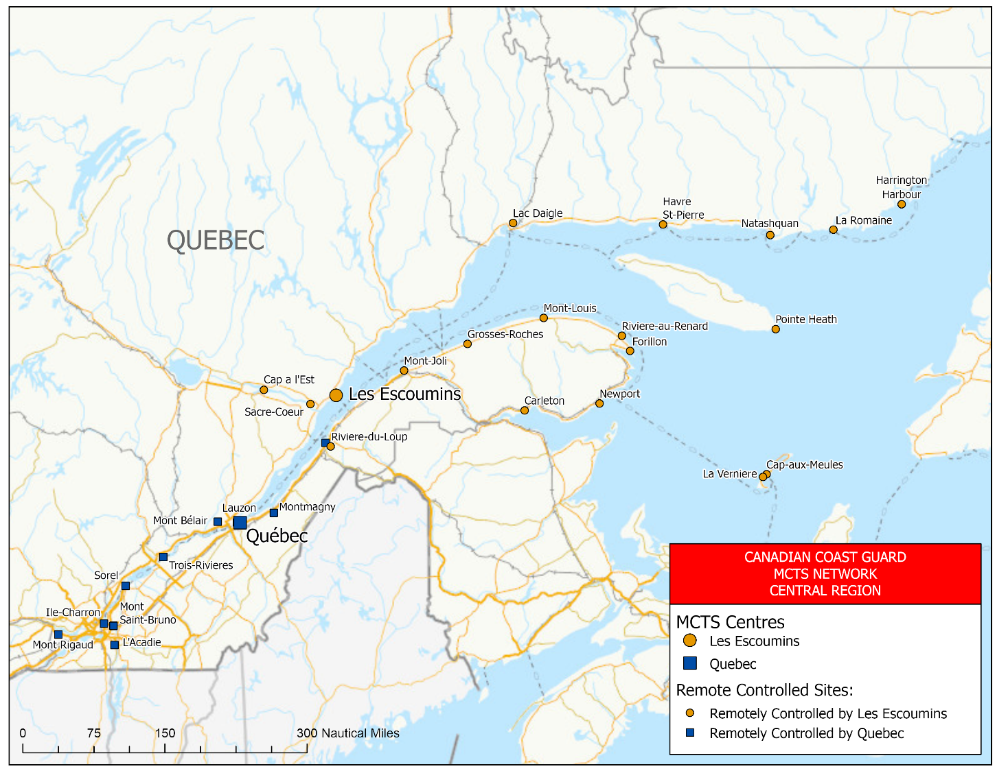
Figure 2-1 - MCTS Network – Central and Arctic Region – Great Lakes
REPLACE WITH THE FOLLOWING:
Figure 2-1 - MCTS Network – Central Region – Great Lakes

Page 2-57
DELETE THE FOLLOWING FIGURE:
Figure 2-2 - MCTS Network – Central and Arctic Region – Gulf and St. Lawrence River
REPLACE WITH THE FOLLOWING:
Figure 2-2 - MCTS Network – Central Region – Gulf and St. Lawrence River
Page 2-58
DELETE THE FOLLOWING FIGURE:
Figure 2-3 - MCTS Network – Central and Arctic Region – Arctic
REPLACE WITH THE FOLLOWING:
Figure 2-3 - MCTS Network – Arctic Region

Page 4-41
DELETE THE FOLLOWING FIGURE:
Figure 4-8 - DGPS Coverage – Central and Arctic Region - St. Lawrence Sector
REPLACE WITH THE FOLLOWING:
Figure 4-8 - DGPS Coverage – Central Region – St. Lawrence Sector

Page 4-42
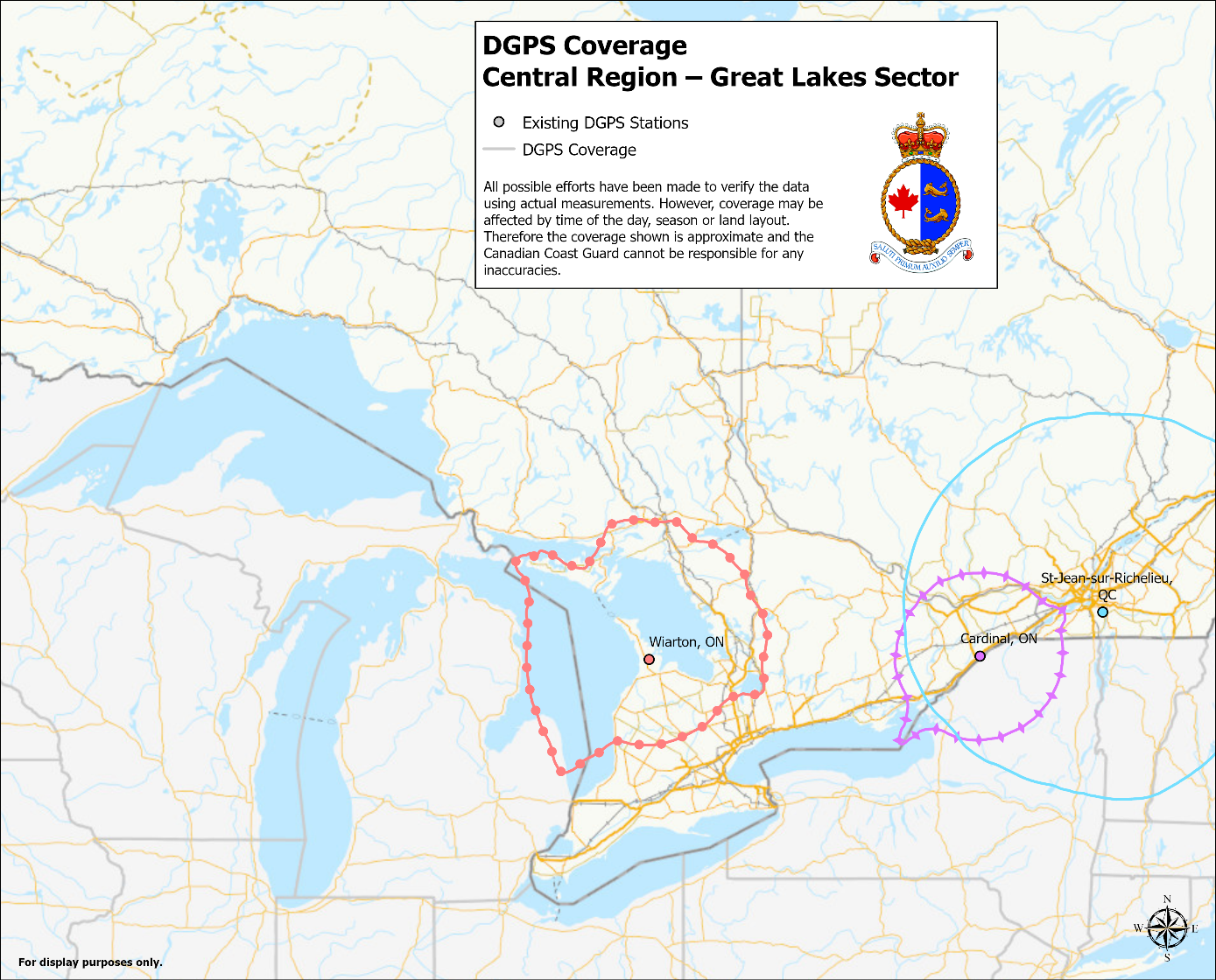
DELETE THE FOLLOWING FIGURE:
Figure 4-9 - DGPS Coverage - Central and Arctic Region – Great Lakes Sector
REPLACE WITH THE FOLLOWING:
Figure 4-9 - DGPS Coverage - Central Region – Great Lakes Sector
Page 4-47
DELETE THE FOLLOWING TABLE:
Table 4-16 - Distribution of Navigational Warnings
REPLACE WITH THE FOLLOWING:
Table 4-16 - Distribution of Navigational Warnings
|
Designator |
NAVWARN Issuing Desk |
Subscription Service |
Internet
|
|
A and H |
Arctic Region |
X |
|
|
C |
Central Region, Great Lakes Sector |
X |
|
|
Q |
Central Region, St. Lawrence Sector |
X |
|
|
M |
Maritimes Region |
X |
|
|
N |
Newfoundland and Labrador Region |
X |
|
|
P |
Western Region |
X |
Page 4-78
AMEND AS FOLLOWS:
2.To inform a quarantine officer, the person in charge of a vessel shall provide a Maritime Declaration of Health by email at phac.cns-snc.aspc@canada.ca. If this method not be available, a person in charge of a vessel shall provide the following information to the nearest MCTS Centre:
a)the name and
nationality of the vessel;
b)the ports
called at during the vessel voyage;
c)the nature of
the cargo on board the vessel;
d)the number of
persons comprising the crew of the vessel;
e)the number of
passengers on board the vessel;
f)the port of
destination of the vessel and the name of the vessel’s
owner or, if the owner is not in Canada, the name of
the vessel’s agent in Canada;
g)the condition
of all persons on board the vessel and details of any
death or illness occurring during the
voyage;
h)whether the
body of any person is being carried on the
vessel;
i)the estimated
time of arrival of the vessel at the port of
destination; and,
j)the date and place of issuance of any de-ratting certificate or de-ratting exemption certificate applicable to the vessel.
3.Notification is requested 48 hours or greater prior to arrival. Should there be any change in the situation being reported, an updated report must be sent.
4.All Maritime Declarations of Health (new or updated) submitted 24 hours or less prior to arrival, must be accompanied by a call to the CNS at 1-833-615-2384.
Page 4-80
DELETE THE FOLLOWING SECTION:
Ice Central and Arctic
REPLACE WITH THE FOLLOWING:
Ice Central
Canadian Coast Guard Ice
Operations Centre
105 McGill Street,
5th floor
Montreal, QC
H2Y 2E7
Arctic Sector
Telephone:514-283-2784
Email: DFO.IceOpsArctic.GlacesOpsArctique.MPO@dfo-mpo.gc.ca
Ice
conditions
Telephone:514-283-1752
514-283-2069
Email:ec.ssgarctique-issarctic.ec@canada.ca
DFO.IceArctic.GlacesArctique.MPO@dfo-mpo.gc.ca
Great Lakes Sector
Telephone:514-283-2784
Email: DFO.IceOpsGreatLakes.GlacesOpsGrandsLacs.MPO@dfo-mpo.gc.ca
Ice
conditions
Telephone:514-283-1752
514-283-2069
Email:ec.ssggrandslacs-issgreatlakes.ec@canada.ca
DFO.IceGreatLakes.GalcesGrandsLacs.MPO@dfo-mpo.gc.ca
St. Lawrence Sector
Telephone:514-283-1746
Email: DFO.IceOpsStLawrence.GlacesOpsStLaurent.MPO@dfo-mpo.gc.ca
Ice conditions
Telephone:514-283-1752
514-283-2069
Email: ec.ssgstlaurent-issstlawrence.ec@canada.ca
The complete version of JIG TP 15163 B (2011) is available at: http://www.tc.gc.ca/eng/marinesafety/tp-tp15163-menu-4025.htm.
Page 4-84
AMEND AS FOLLOWS:
CCG Central and Arctic Region (Ontario)
Telephone: 613-925-4842
Email: TSCCNA@dfo-mpo.gc.ca
•In the subject of the email, please state: SRI – "Ship's Name"
•In the body of the email, please include any contact information for the vessel.
CCG Central and Arctic Region (Québec)
Fisheries and Oceans Canada
Telephone: 514-283-5684
Email: spvr.email@stericycle.com
SECTION 4 - SAILING DIRECTIONS AND SMALL CRAFT GUIDE CORRECTIONS
ARC 404 — Great Slave Lake and Mackenzie River, First Edition, 2012 —
Chapter 1 — Paragraph 50, after “in Moraine Bay.”
Delete: “The barge is marked with hazard buoys.”
(C2020-012.01)
SECTION 5 - LIST OF LIGHTS, BUOYS AND FOG SIGNALS CORRECTIONS
NO CORRECTION FOR THIS SECTION.
CANADIAN COAST GUARD - MARINE INFORMATION REPORT AND SUGGESTION SHEET
Name of Ship or Sender:..................................................................... Date:....................................
Address of Sender:..........................................................................................................................
Street # Street Name
Town / City:.............................. Prov / State:....................... Postal Code / Zip Code: ........................
Tel / Fax / E-mail address of sender (if appropriate):............................................................................
Observation Date:............................................. Time (UTC): ...........................................................
Geographical Position:......................................................................................................................
Coordinate Position: Lat: ............................................... Long:.........................................................
Position Method: DGPS GPS with WAAS GPS Radar Other
Horizontal Datum Used: WGS 84 NAD 27 Other
Estimated Position Accuracy:............................................................................................................
Chart #:............................................................ Datum: NAD 27 NAD 83
Chart Edition:.................................................... Last Correction applied:............................................
Publications affected: (Quote edition and page number):.....................................................................
*Full details (Attach additional sheets as necessary):...........................................................................
Mariners are requested to notify the responsible authorities when new or suspected dangers to navigation are discovered, changes are observed in aids to navigation, or corrections to publications are seen to be necessary.
In the case of new or suspected dangers to navigation, it is important that all details be given in order to aid with future investigations. Items of interest include heights, depths, physical description, type of bottom and equipment method used to position the item. It is helpful to mark details on the chart, which will be promptly replaced by the Canadian Hydrographic Service.
Reports should be made to the nearest Marine Communications and Traffic Services Centre (MCTS) and should be confirmed in writing to:
Leader, Notices to Mariners
Canadian Coast Guard
Department of Fisheries and Oceans
Montréal, QC H2Y 2E7
In the case of information concerning aids to navigation or the List of Lights, Buoys and Fog Signals book.
OR
Director General, Canadian Hydrographic Service & Oceanographic Services
Department of Fisheries and Oceans
Ottawa, ON K1A 0E6
In the case of new or suspected dangers to navigation or where corrections to "Sailing Directions" appear to be necessary.
For general questions on Canadian Coast Guard programs or services, please send an e-mail to:
info@dfo-mpo.gc.ca (Please include your postal code and e-mail address).
You can access the online form on the following page: https://www.notmar.gc.ca/incident-en.php or you can use the printable pdf version : https://www.notmar.gc.ca/publications/monthly-mensuel/images/monthly-form-en.pdf