
Archived information
The Standard on Web Usability replaces this content. This content is archived because Common Look and Feel 2.0 Standards have been rescinded.
Archived information is provided for reference, research or recordkeeping purposes. It is not subject to the Government of Canada Web Standards and has not been altered or updated since it was archived.
Notices to Mariners
May 26, 2023

Safety First, Service Always
Monthly Western Edition
CONTENTS
| Section 1 | General and Safety Information |
| Section 1A | Temporary and Preliminary Notices |
| Section 2 | Chart Corrections |
| Section 3 | Radio Aids to Marine Navigation Corrections |
| Section 4 | Canadian Sailing Directions Corrections |
| Section 5 | List of Lights, Buoys and Fog Signals Corrections |
Notices to Mariners – Monthly Western Edition
Edition No. 05/2023
Aussi disponible en français :
Avis aux navigateurs – Édition mensuelle de l’Ouest
Édition n° 05/2023
Published under the Authority of:
Canadian Coast Guard Programs
Aids to Navigation and Waterways
Fisheries and Oceans Canada
Montreal, QC H2Y 2E7
For more information, contact Notmar.XNCR@dfo-mpo.gc.ca.
© His Majesty the King in Right of Canada,
as represented by the Minister of Fisheries, Oceans
and the Canadian Coast Guard, 2023.
Cat. No. Fs152-9E-PDF (Electronic PDF, English)
ISSN 2817-0253
Cat. No. Fs152-9F-PDF (Electronic PDF, French)
ISSN 2817-0261
Explanatory Notes – Notices to Mariners (NOTMAR)
Geographical positions refer directly to the graduations of the largest scale Canadian Hydrographic Service chart (unless otherwise indicated).
Bearings refer to the true compass and are measured clockwise from 000° (North) clockwise to 359°; those relating to lights are from seaward.
Visibility of lights is that in clear weather.
Depths - The units used for soundings (metres, fathoms or feet) are stated in the title of each chart.
Elevations are normally given above Higher High Water, Large Tide (unless otherwise indicated).
Distances may be calculated as follows:
1 nautical mile = 1,852 metres (6,076.1 feet)
1 statute mile = 1,609.3 metres (5,280 feet)
1 metre = 3.28 feet
Temporary and Preliminary Notices to Mariners – Section 1A of Notices to Mariners
These notices are indicated by a (T) or a (P), respectively. Please note that nautical charts are not amended by the Canadian Hydrographic Service for temporary (T) and preliminary (P) notices. It is recommended that mariners chart these corrections in pencil. For the list of charts affected by (T) & (P) notices, please refer to the current Notices to Mariners - Monthly Summary of Temporary and Preliminary Notices publication.
Suggestions and Corrections Form
This form is specifically for suggestions and corrections to Notices to Mariners publications. It is available online and also in fillable PDF format included with the monthly publication ZIP file.
To submit comments and suggestions on possible improvements to the various publications and services: Notmar.XNCR@dfo-mpo.gc.ca.
To report chart discrepancies and/or corrections to the Canadian Sailing Directions booklets: Fill out the Marine Information Reporting Form and/or email chsinfo@dfo-mpo.gc.ca.
To report emergencies or navigational hazards: Contact your nearest MCTS centre
- VHF channel 16 (156.8 MHz)
- MF/HF frequency 2182 kHz/4125 kHz (where available)
- ∗16 on a cellphone (where available)
NOTMAR Website – Monthly Editions, Chart Corrections and Chart Patches
The NOTMAR website allows users to access the monthly publications,
chart corrections, and chart patches.
Users can subscribe for free to the email notification service
to receive notifications when charts of interest are updated, including their patches, as well as when a new Monthly Edition of Notices to Mariners is published.
In addition, the monthly publication and related
files to download, such as chart patches, can be obtained
all together through the download of a single ZIP file.
Explanatory Notes – Canadian Hydrographic Service (CHS)
Chart Corrections – Section 2 of Notices to Mariners
Corrections to nautical charts will be listed in numerical order by chart number. Each chart correction listed applies only to that particular chart. Related charts, if any, will have their own specific correction listed separately.
Users should also refer to CHS Chart 1: Symbols, Abbreviations and Terms for additional information pertaining to the correction of charts.
The illustration below describes the elements that will comprise a typical Section 2 chart correction:

The last correction number is identified with the LNM/D or Last Notice to Mariners Number / Date.
Mariners are advised that only the most critical changes that directly affect safety to navigation are issued in “Section 2 – Chart Corrections.” This limitation is required to ensure that charts remain as clear and easy to read as possible. As a result, mariners may see minor discrepancies of a non-critical nature between information in official publications. For example, a small change in the nominal range or focal height of a light may not result in the production of a chart correction in Notices to Mariners, but may result in a correction in the List of Lights, Buoys and Fog Signals publication.
Note: In the case of a discrepancy between information provided on CHS charts relating to aids to navigation, and the List of Lights, Buoys and Fog Signals publication, the latter shall be deemed as containing the most up-to-date information.
Canadian Nautical Charts & Publications
A source list of Canadian nautical charts and publications is published in Notice No. 14 of the Notices to Mariners Annual Edition 2023. The source supply and the prices effective at the time of printing are listed. For current chart edition dates, please refer to the following website: www.chs-shc.gc.ca/charts-cartes/paper-papier/index-eng.asp
Explanatory Notes – Marine Communications and Traffic Services (MCTS)
Navigational Warnings / Notices to Shipping
The Canadian Coast Guard (CCG) is implementing a number of changes to the aids to navigation system in Canada.
These changes are advertised as Navigational Warnings, formerly called Notices to ShippingFootnote 1, that are broadcast by the CCG, and are then followed up with Notices to Mariners, then charts are updated by hand correction, reprints or new editions.
Mariners are advised that all relevant Navigational Warnings (NAVWARN) should be kept until superseded by Notices to Mariners or through revised charts issued by the Canadian Hydrographic Service (CHS).
NAVWARN are accessible on the applicable regional page on the CCG Navigational Warnings website at http://nis.ccg-gcc.gc.ca.
CHS is reviewing the impact of these changes with CCG and together are preparing an action plan on the issuing of chart revisions.
For further information, contact your regional NAVWARN Issuing Desk.
Western Region
Prince Rupert MCTS Centre
Canadian Coast Guard
Bag 4444
Prince Rupert, BC V8J 4K2
Telephone: 250-627-3070
Email: NAVWARN.MCTSPrinceRupert@innav.gc.ca
Website: http://www.marinfo.gc.ca/e-nav
Arctic Region
* Iqaluit MCTS Centre
Operational from approximately mid-May until late December.
Canadian Coast Guard
P.O. Box 189
Iqaluit, NU X0A 0H0
“A” Series
Telephone: 867-979-5269
“H” Series
Telephone: 867-979-0310
Facsimile: 867-979-4264
Email: NAVWARN.MCTSIqaluit@innav.gc.ca
Website: http://www.marinfo.gc.ca/e-nav
* Service available in English and French.
Index
Numerical Index of Canadian Charts Affected
This numerical index lists all nautical charts mentioned in this monthly edition of Notices to Mariners. Only charts appearing in Section 2 of this publication require a chart correction. The appearance of charts in all other sections, particularly those related to the correction of other nautical publications, is included here for reference.
| 3000 | 3526 | 3549 | 3813 |
| 3001 | 3527 | 3601 | 4381 |
| 3461 | 3547 | 3603 | 4453 |
| 3513 | 3548 | 3811 |
SECTION 1 - GENERAL AND SAFETY INFORMATION
*1105/21West Coast Haida Gwaii – Voluntary Protection Zone for Shipping
(Recurrent publication of notice *1105/21, originally published in the Notices to Mariners – Monthly Western Edition 11/2021 publication.)
Reference: Notice *903/21 is cancelled.
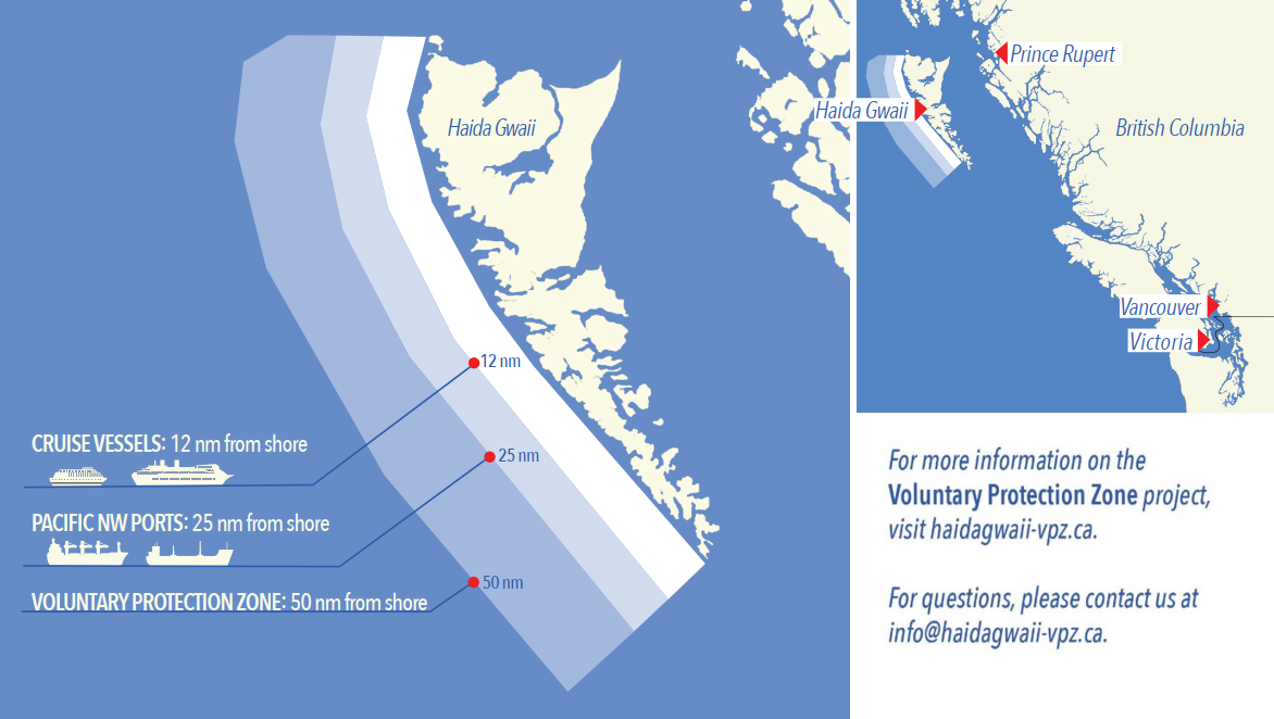
Voluntary Protection Zone for Shipping, West Coast Haida Gwaii (formerly Queen Charlotte Islands)
Haida Gwaii’s remote location, rugged coastline, variable sea
and weather conditions, and rich ecological and cultural
heritage make it vulnerable to the potential for pollution from
shipping breakdowns and accidents. Increasing the distance
vessels travel offshore can increase the amount of time
available to address propulsion, steering or other issues, and
the likelihood of a towing vessel being able to respond to a
vessel that is disabled or drifting. This in turn reduces the
risk of grounding and oil spills.
A Voluntary Protection Zone for Shipping on the West Coast of
Haida Gwaii is currently in effect. In the Voluntary
Protection Zone, commercial vessels of 500 gross tonnage or
greater shall observe a minimum distance of 50 nautical miles
offshore when transiting along the West Coast of Haida Gwaii
with the following exceptions:
–Cruise vessels, to observe a minimum 12 nm distance from shore;
–Vessels transiting between Pacific Northwest ports
(Washington, Alaska, BC), to observe a minimum 25 nm distance
from shore;
–Tugs and barges (including pushing and towing
alongside), no minimum distance; and
–Fishing vessels, no minimum distance.
The Voluntary Protection Zone for Shipping coordinates are:
|
54⁰ 15.436' N |
133⁰ 04.788' W |
|
54⁰ 17.572' N |
134⁰ 02.484' W |
|
54⁰ 13.614' N |
134⁰ 19.427' W |
|
54⁰ 11.786' N |
134⁰ 30.841' W |
|
53⁰ 44.036' N |
134⁰ 32.677' W |
|
53⁰ 11.118' N |
134⁰ 16.412' W |
|
52⁰ 18.483' N |
133⁰ 20.917' W |
|
51⁰ 24.590' N |
132⁰ 04.081' W |
|
51⁰ 56.158' N |
131⁰ 01.830' W |
Vessels are requested to adhere to these distances on a voluntary basis and only when it does not jeopardize the safety of navigation, the vessel, the persons aboard, and the cargo.
(NW-P-1085-20)
*905/22Transport Canada – British Columbia North Coast Waterway Management Guidelines
(Recurrent publication of notice *905/22, originally published in the Notices to Mariners – Monthly Western Edition 09/2022 publication.)
The North Coast Waterway Management Guidelines are voluntary guidelines that aim to improve safety on the water by reducing conflicts between First Nations’ marine use activities, such as fishing and shoreline harvesting, and commercial vessels on the shipping route between Kitimat and Browning Entrance. The guidelines came into effect on September 1, 2022, and will be reviewed from time to time.
The guidelines apply to all vessels navigating on the route between Kitimat and Browning Entrance, on the north coast of British Columbia. This area includes:
|
•Douglas Channel |
•Otter Channel |
|
•Wright Sound |
•Nepean Sound, and |
|
•Lewis Passage |
•Principe Channel |

The complete guidelines document is available at the following link:
Nothing in these guidelines replaces or changes how we apply any Canadian or international laws or regulations, including the Collision Regulations. Furthermore, nothing in these guidelines prevents or limits the master or pilot of a ship from making any decisions to protect the vessel, the crew, or the marine environment.
The guidelines include information for:
•all vessels that covers:
-inshore safety zones
-routing measures
-speed reductions
-guidelines for meeting and passing
-a special operating area in Wright Sound, and
-guidelines in case of a mechanical or electrical breakdown
•large commercial ships, including bulk carriers,
general cargo vessels, liquid bulk vessels, and passenger
vessels
•tugs and barges, and
•vessels operating in First Nations Areas of Concern where you must pay special attention to make sure local community users can transit and use the area safely.
*204/23Canadian Coast Guard – Cessation of Rectangular Broadcasting in NAVAREA / METAREAs XVII and XVIII
(Recurrent publication of notice *204/23, originally published in the Notices to Mariners – Monthly Western Edition 02/2023 publication.)
Since 2010, the five Arctic NAVAREA/METAREAs have promulgated warnings and forecasts to their areas of responsibility using INMARSAT-C’s rectangular area addressing capability. At that time, it was not possible to code older Inmarsat-C receivers to receive warnings and forecasts directly addressed to the Arctic NAVAREA/METAREAs.
All Inmarsat-C and Mini-C receivers available for purchase today are able to receive warnings and forecasts addressed to the Arctic NAVAREA/METAREAs, and have been for more than a decade.
Effective on January 1st, 2024, the Arctic NAVAREA/METAREAs will commence broadcasting their warnings and forecasts using their unique numeric identifier and will cease using rectangular addressing.
During 2023, the Arctic NAVAREA/METAREAs will transmit test messages using the numeric NAVAREA/METAREA identifier to allow mariners to verify reception on their Inmarsat-C or Mini-C receivers.
Mariners navigating in Arctic waters must ensure that their Inmarsat-C or Mini-C receiver detects the new encoding prior to January 1st, 2024 to continue receiving Arctic NAVAREA/METAREA warnings and forecasts.
*205/23Vancouver Fraser Port Authority – Anchorage Code of Conduct
(Recurrent publication of notice *205/23, originally published in the Notices to Mariners – Monthly Western Edition 02/2023 publication.)
Purpose of the Code of Conduct:
–The objective of the anchorage code of conduct is to promote enhanced ship safety and environmental protection, while also reducing the effects of ship movements on local communities. Anchorages in Southern British Columbia lie in significantly eco-sensitive coastal waters and have the potential to affect the quality of life for neighbouring coastal and Indigenous communities unless strict mitigations, including the minimization of noise and light pollution, are taken.
–The anchorage code of conduct applies to all anchorages assigned and managed by the Vancouver Fraser Port Authority, and shall apply at all times, except when instructed by the port authority or the Canadian Coast Guard, and in emergencies when it is the responsibility of the Master to take any and all action to ensure safety of their vessel consistent with the prevailing circumstances and conditions.
Accessing the anchorage code of conduct:
–The code of conduct applies to all anchorages assigned by the Vancouver Fraser Port Authority both within the Port of Vancouver and the Southern Gulf Islands.
–The code of conduct is accessed via the Vancouver Fraser Port Authority’s Port Information Guide available at https://www.portvancouver.com/marine-operations/.
*310/23Canadian Coast Guard – Differential Global Positioning System (DGPS) in Canada
(Recurrent publication of notice *310/23, originally published in the Notices to Mariners – Monthly Western Edition 03/2023 publication.)
Reference: Notice *1206/22 is cancelled.
On December 15th, 2022, the Canadian Coast Guard (CCG) permanently discontinued the provision of its DGPS service across Canada.
Today’s GPS meets the needs of international Position, Navigation and Timing (PNT) requirements for maritime navigation. Further, for mariners in Canadian waters, there is no carriage requirement for ground - or space - based augmentation capability onboard vessels for Global Navigation Satellite Systems (GNSS).
Mariners should note that CCG DGPS sites may broadcast corrections on occasion for technology testing. During these testing, the DGPS corrections broadcasted should not be considered reliable for marine navigation.
*501/23Canadian Hydrographic Service – Nautical Charts
|
Charts |
Main Title |
Scale |
Edition Date |
Published |
Cat# |
Price |
|
New Charts |
||||||
|
3813 |
Port Louis and Otard Bay |
1:12 000 |
2023-05-19 |
2023-05-26 |
2 |
$20.00 |
|
New Editions |
||||||
|
4381 |
Mahone Bay |
1:40 000 |
2023-04-28 |
2023-05-05 |
1 |
$20.00 |
|
4453 |
Île à la Brume à/to Pointe Curlew |
1:70 000 |
2023-04-28 |
2023-05-12 |
1 |
$20.00 |
*502/23Canadian Hydrographic Service – Electronic Navigational Charts
|
S-57 ENC Number |
Chart Title |
ENC Compilation Scale |
Published |
|
New Charts |
|||
|
CA43MMHA (Edn 1.000) |
CA43MMHA |
1:11 000 |
2023-05-26 |
|
CA43XMHA (Edn 1.000) |
CA43XMHA |
1:11 000 |
2023-05-26 |
|
CA540MRA (Edn 1.000) |
CA540MRA |
1:2 000 |
2023-05-26 |
|
CA55LS9A (Edn 1.000) |
Port5050N5730W |
1:11 000 |
2023-05-12 |
|
CA55MS8A (Edn 1.000) |
Port5060N5740W |
1:11 000 |
2023-05-12 |
|
CA55MS9A (Edn 1.000) |
Port5060N5730W |
1:11 000 |
2023-05-12 |
|
CA571156 (Edn 1.000) |
Windy Bay |
1:11 000 |
2023-05-12 |
|
CA571157 (Edn 1.000) |
Windy Bay |
1:11 000 |
2023-05-12 |
|
CA571159 (Edn 1.000) |
Tasu Sound |
1:11 000 |
2023-05-19 |
|
CA571160 (Edn 1.000) |
Tasu Sound |
1:11 000 |
2023-05-19 |
|
CA571161 (Edn 1.000) |
Tasu Sound |
1:11 000 |
2023-05-19 |
|
CA571162 (Edn 1.000) |
Tasu Sound |
1:11 000 |
2023-05-19 |
|
CA571163 (Edn 1.000) |
Tasu Sound |
1:11 000 |
2023-05-19 |
|
CA576860 (Edn 1.000) |
Deep Cove |
1:5 000 |
2023-05-05 |
|
New Editions |
|||
|
CA376032 (Edn 3.000) |
Traffic Zone into Halifax |
1:72 500 |
2023-05-12 |
|
CA376153 (Edn 5.000) |
Trinity Bay - Southern Portion/Partie Sud |
1:30 000 |
2023-05-26 |
|
CA476199 (Edn 6.000) |
Mahone Bay |
1:20 000 |
2023-05-05 |
|
CA4B71TA (Edn 2.000) |
CA4B71TA |
1:90 000 |
2023-05-19 |
|
CA576200 (Edn 9.000) |
Chester Harbour |
1:7 500 |
2023-05-05 |
|
CA576201 (Edn 6.000) |
Mahone Harbour |
1:7 500 |
2023-05-05 |
|
CA576741 (Edn 2.000) |
Martins Point |
1:7 500 |
2023-05-05 |
|
Charts Permanently Withdrawn |
|||
|
CA479239 |
Lac Memphrémagog A-B |
Cancelled by CA43XMHA |
|
|
CA479240 |
Lac Memphrémagog B-C |
Cancelled by CA43XMHA,CA43MMHA |
|
|
CA576857 |
Port Saunders |
Cancelled by CA55MS9A |
|
|
CA579241 |
Magog |
Cancelled by CA540MRA |
|
*503/23Transport Canada – Ship Safety Bulletins #06, #07, #08 and #09/2023
New Ship Safety Bulletins have recently been
posted on the
Transport Canada website.
To view or download these bulletins, please click on the
links below:
SSB#06/2023 – Temporary Measures
Regarding Marine Medical Certificates, April
2023
RDIMS#
19413369
SSB#07/2023 – Temporary Measures
Regarding Marine Personnel Certificates– Excluding Marine
Medical
Certificates
RDIMS#
19413449
SSB#08/2023 – Enhanced
environmental measures for the 2023 cruise
season
RDIMS#
19329417
SSB#09/2023 – New Greenhouse Gas
Reporting
Requirements
RDIMS#
19125977
Sign up for
e-Bulletin to receive an e-mail notice each time a new
Ship Safety Bulletin is published on our website.
Contact us at marinesafety-securitemaritime@tc.gc.ca
or 1-855-859-3123 (Toll Free).
*504/23Canadian Coast Guard Publication – Amendments to Notices to Mariners Annual Edition 2023 - Section A2, Notice 5A: General Regulatory Requirements for all Oceans Act Marine Protected Areas
Page 28
DELETE AS FOLLOWS:
Slow down to 10 knots or less (yellow area):
To reduce the risk of underwater noise disturbance and
collisions with whales within this area, it is recommended that
vessels should slow down to a maximum speed through the water
of 10 knots, remain in the navigation and marked community supply
channels and post a lookout.
Page 29
REPLACE IMAGE WITH THE FOLLOWING:

Page 32
DELETE AS FOLLOWS:
Slow down to 10 knots or less (yellow area):
To reduce the risk of underwater noise disturbance and
collisions with whales within this area, it is recommended that
vessels should slow down to a maximum speed through the water
of 10 knots, remain in the navigation and marked community supply
channels and post a lookout.
Page 33
REPLACE IMAGE WITH THE FOLLOWING:
*505/23Canadian Hydrographic Service – Magnetic Declination Calculations
Mariners are advised that CHS has adopted the harmonized World Magnetic Model (WMM), as found on the NCEI/NOAA website. Old compass rose declination information on CHS navigational products can be updated using this website: https://www.ngdc.noaa.gov/geomag/calculators/magcalc.shtml#declination. While the differences in the model declinations are small each year, they can become more significant over a large period of time.
*506/23Canadian Hydrographic Service – Chart 3811 Partially Replaced by New Chart 3813
Chart 3811, Plans - Harbours in Queen Charlotte Islands/Havres dans Îles de la Reine-Charlotte, has been partially replaced by new chart 3813. The only plan replaced is Port Louis and/et Otard Bay plan. Remaining plans will be cancelled at a later date.
*508/23Anguniaqvia Niqiqyuam Marine Protected Areas (ANMPA) and Tarium Niryutait Marine Protected Areas (TNMPA) – Beluga and Bowhead Whale Protection: Voluntary Avoidance and Slowdown Areas
The two established Marine Protected Areas (MPAs) in Canada’s Western Arctic are located within the Inuvialuit Settlement Region, as such all activities must comply with the Inuvialuit Final Agreement. Protection and preservation of Arctic wildlife, the environment and biological productivity is one of the principles of the Inuvialuit Final Agreement and it is this principle that led the Inuvialuit Regional Corporation and the Inuvialuit Game Council to initiate establishment of the Western Arctic MPAs. The waters in and near the MPAs, and the offshore marine habitats of the Beaufort Sea and Amundsen Gulf, are important summer foraging habitats used seasonally (May-October) by the Eastern Beaufort Sea beluga stock, and the Bering-Chukchi-Beaufort bowhead population.
REGULATORY PROTECTION MEASURES
All whale species are protected under the Marine Mammal
Regulations, pursuant to the Fisheries Act. Within the
boundaries of the MPAs, a general prohibition is set out in the
Regulations, pursuant to the Oceans Act. Any incident
with a marine mammal within the MPAs must be reported within
two hours after its occurrence, to the Canadian Coast Guard.
For marine wildlife sightings and incidents such as collisions
that occur outside the MPAs or for any situation involving a
marine mammal that is dead or in trouble, contact Fisheries and
Oceans Canada, Inuvik office at (867) 777-7500.
For more information on the ANMPA and TNMPA, including local
contacts and species specific minimum distances, see Section
A2 - Notices 5 and 5A.3 of the Notices to Mariners Annual
Edition 2023.
VOLUNTARY PROTECTION MEASURES
Voluntary measures are in effect from June 1st
to October
31st,
2023. See map above.
These measures apply to merchant vessels, cruise ships, small
vessels and adventure craft within the boundaries of the MPAs
and the additional identified areas to prevent collisions
with whales and to mitigate the underwater noise generated by
the vessels. These measures should only be taken when they
will not jeopardize navigational safety.
Avoid (red area): To reduce the risk of underwater noise disturbance and collisions with whales within the MPAs, vessels should avoid transiting through the MPAs if possible. If passage through this area is required, vessels should slow down to a maximum speed through the water of 10 knots and post a lookout such as a marine mammal observer in order to increase the chances of seeing the whales and thus taking necessary measures to avoid them. If bypassing the whales is not possible, slow down and wait for the animals to move away to a distance greater than 400 metres (0.215 nautical miles) before resuming original speed up to 10 knots. It is more difficult to see the animals in rain, fog, or in rough sea states, therefore increased caution is recommended.
Slow down to 10 knots or less (yellow area): To reduce the risk of underwater noise disturbance and collisions with whales within this area, it is recommended that vessels should slow down to a maximum speed through the water of 10 knots, remain in the marked community supply channels and post a lookout.
These voluntary measures are secondary to rights under the Inuvialuit Final Agreement.
MPA Coordinates
The Tarium Niryutait Marine Protected Areas consist of three areas of the Mackenzie Bay: Okeevik, Kittigaryuit and Niaqunnaq. The three areas are bounded by rhumb lines connecting the following geographical coordinates [North America Datum 1983 (NAD 83)/World Geodetic System (WGS 84)].
|
Okeevik Sub Area |
|
Kittigaryuit Sub Area |
||||
|
Point |
Latitude (North) |
Longitude (West) |
|
Point |
Latitude (North) |
Longitude (West) |
|
1 |
69° 38’ 19” |
135° 25’ 09” |
|
1 |
69° 35’ 10” |
133° 48’ 26” |
|
2 |
69° 38’ 03” |
135° 25’ 11” |
|
2 |
69° 34’ 00” |
133° 28’ 00” |
|
3 |
69° 37’ 46” |
135° 24’ 52” |
|
3 |
69° 23’ 37” |
133° 26’ 40” |
|
4 |
69° 29’ 49” |
135° 12’ 49” |
|
4 |
69° 20’ 34” |
133° 40’ 37” |
|
5 |
69° 30’ 45” |
135° 16’ 56” |
|
5 |
69° 19’ 05” |
133° 42’ 21” |
|
6 |
69° 29’ 26” |
135° 18’ 53” |
|
6 |
69° 19’ 01” |
133° 42’ 31” |
|
7 |
69° 29’ 23” |
135° 19’ 06” |
|
7 |
69° 20’ 39” |
133° 43’ 20” |
|
8 |
69° 28’ 07” |
135° 20’ 25” |
|
8 |
69° 16’ 42” |
133° 54’ 54” |
|
9 |
69° 27’ 36” |
135° 24’ 25” |
|
9 |
69° 15’ 20” |
134° 06’ 53” |
|
10 |
69° 25' 51” |
135° 32’ 27” |
|
10 |
69° 16’ 33” |
134° 05’ 56” |
|
11 |
69° 26’ 32” |
135° 34’ 54” |
|
11 |
69° 20’ 42” |
134° 02’ 44” |
|
12 |
69° 28’ 21” |
135° 35’ 24” |
|
12 |
69° 24’ 00” |
133° 59’ 10” |
|
13 |
69° 28’ 35” |
135° 36’ 40” |
|
13 |
69° 24’ 34” |
133° 53’ 49” |
|
14 |
69° 28’ 39” |
135° 37’ 58” |
|
14 |
69° 28’ 21” |
133° 48’ 15” |
|
15 |
69° 30’ 34” |
135° 45’ 54” |
|
15 |
69° 28’ 02” |
133° 50’ 59” |
|
16 |
69° 35’ 18” |
135° 35’ 42” |
|
16 |
69° 33’ 20” |
133° 47’ 29” |
|
17 |
69° 36’ 00” |
135° 22’ 10” |
|
17 |
69° 34’ 33” |
133° 47’ 42” |
|
18 |
69° 34’ 40” |
135° 20’ 09” |
|
18 |
69° 32’ 55” |
133° 51’ 09” |
|
19 |
69° 34’ 00” |
135° 20’ 09” |
|
19 |
69° 32’ 56” |
133° 51’ 54” |
|
20 |
69° 34’ 00” |
135° 27’ 39” |
|
20 |
69° 33’ 46” |
133° 55’ 48” |
|
21 |
69° 36’ 00” |
135° 27’ 39” |
|
21 |
69° 33’ 46” |
133° 55’ 31” |
|
22 |
69° 27’ 00” |
135° 31’ 11” |
|
|
|
|
|
23 |
69° 27’ 00” |
135° 34’ 45” |
|
|
|
|
|
Niaqunnaq Sub Area |
||
|
Point |
Latitude (North) |
Longitude (West) |
|
1 |
69° 08’ 00” |
136° 16’ 44” |
|
2 |
69° 04’ 25” |
136° 07’ 45” |
|
3 |
69° 03’ 43” |
136° 07’ 08” |
|
4 |
69° 01’ 19” |
136° 04’ 45” |
|
5 |
69° 01’ 14” |
136° 04’ 45” |
|
6 |
69° 00’ 57” |
136° 05’ 42” |
|
7 |
69° 00’ 12” |
136° 07’ 08” |
|
8 |
68° 57’ 00” |
136° 10’ 00” |
|
9 |
68° 55’ 00” |
136° 15’ 00” |
|
10 |
68° 54’ 22” |
136° 31’ 50” |
|
11 |
68° 55’ 00” |
136° 38’ 33” |
|
12 |
68° 56’ 15” |
137° 00’ 41” |
|
13 |
68° 56’ 29” |
137° 03’ 03” |
|
14 |
68° 55’ 48” |
137° 11’ 00” |
|
15 |
68° 57’ 50” |
137° 16’ 40” |
|
16 |
68° 59’ 20” |
137° 21’ 30” |
|
17 |
69° 03’ 09” |
137° 44’ 54” |
The Anguniaqvia niqiqyuam Marine Protected Areas consist of two areas in Darnley Bay and Amundsen Gulf in the Beaufort Sea: Zone 1 and Zone 2. The areas consist of the seabed, the subsoil to a depth of five metres and the water column, including the sea ice. The two areas are bounded by straight lines connecting the following geographical coordinates [North America Datum 1983 (NAD 83)].
|
Zone 1 |
||
|
Point |
Latitude (North) |
Longitude (West) |
|
A |
69° 21’ 07.8” |
124° 21’ 32.0” approx |
|
B |
70° 12’ 00.0” approx |
124° 31’ 55.2” |
|
C |
70° 08’ 22.0” |
124° 41’ 45.0” approx |
|
D |
70° 09’ 09.9” |
124° 57’ 42.0” approx |
|
E |
70° 09’ 13.0” approx |
125° 05’ 28.6” |
|
F |
70° 09’ 13.2” |
125° 17’ 53.0” |
|
G |
70° 20’ 00.0” |
125° 17’ 53.0” |
|
H |
70° 20’ 00.0” |
123° 54’ 17.5” |
|
I |
69° 37’ 20.6” |
123° 54’ 17.5” |
|
J |
69° 30’ 00.0” |
124° 15’ 34.7” |
|
|
||
|
Zone 2 |
||
|
Point |
Latitude (North) |
Longitude (West) |
|
K |
70° 04’ 15.8” |
124° 41’ 51.0” approx |
|
L |
70° 04’ 48.6” |
124° 41’ 54.0” approx |
|
M |
70° 02’ 12.9” |
124° 35’ 23.0” approx |
|
N |
70° 02’ 12.9” |
124° 35’ 29.0” approx |
Section 1A: Temporary and Preliminary Notices
Reminder – Comment Period for Active Preliminary Notices
No notices applicable for this edition.
Inland Waters
Temporary Notices
No notices applicable for this edition.
Preliminary Notices
No notices applicable for this edition.
Pacific Coast
Temporary Notices
No notices applicable for this edition.
Preliminary Notices
No notices applicable for this edition.
SECTION 2 - CHART CORRECTIONS
3000 - Juan de Fuca Strait to/à Dixon Entrance - New Edition - 20-JAN-1989 - NAD 1927
(See Chart 1, Q58)
3001 - Vancouver Island / Île de Vancouver, Juan de Fuca Strait to/à Queen Charlotte Sound - New Edition - 23-FEB-2001 - NAD 1927
(See Chart 1, Q58)
3461 - Juan de Fuca Strait, Eastern Portion/Partie Est - New Edition - 01-JUL-2005 - NAD 1983
(See Chart 1, P60)
3513 - Strait of Georgia, Northern Portion/Partie Nord - New Edition - 29-OCT-1999 - NAD 1983
(See Chart 1, P1)
3526 - Howe Sound - New Edition - 01-JUL-2005 - NAD 1983
(See Chart 1, Q58)
3527 - Baynes Sound - New Edition - 06-APR-2001 - NAD 1983
Download Patch - https://www.notmar.gc.ca/chsftp/patches/3527_6204718_1_202304251407.pdf
3601 - Juan de Fuca Strait to/à Vancouver Harbour - New Edition - 01-JUL-2005 - NAD 1983
(See Chart 1, P60)
3603 - Ucluelet Inlet to/à Nootka Sound - New Edition - 23-OCT-1981 - NAD 1927
(See Chart 1, Q58)
SECTION 3 - RADIO AIDS TO MARINE NAVIGATION CORRECTIONS
*514/23Radio Aids to Marine Navigation 2023 (Atlantic, St. Lawrence, Great Lakes, Lake Winnipeg, Arctic and Pacific)
Page 1-2
ADD AS FOLLOWS:
1.1.6Elimination of the H Series in the NAVWARN Issuing System
As of July 1, 2023, Navigational Warnings (NAVWARNs) for the Mackenzie River will be issued under the A series rather than the H series. Existing H series NAVWARNs will remain available on the website. Current subscribers to the NAVWARN subscription service will continue to receive NAVWARNs for all geographic areas that match the user defined criteria. No action will be required on the part of the user.
Page 4-71
DELETE THE FOLLOWING SECTION:
4.3.8.5 Quarantine Messages
REPLACE WITH:
4.3.8.5 Quarantine Messages
1.In the following circumstances, and per the Quarantine Act, the person in charge of a vessel shall inform a quarantine officer prior to entering or exiting Canada where, in the course of the voyage:
A.1. A person on board meets the syndromal case definition:
a)has a fever of 38°C or greater or 2 or more signs of fever, such as:
•shivering
•flushed skin
•excessive sweating
•complaints of feeling feverish
b)and has 1 or more of the following symptoms:
•difficulty breathing
•repeated cough
•diarrhea
•headache
•recent confusion
•skin rash
•bruising or bleeding without previous injury
2. Appears obviously unwell or coughs with blood
B.There is a death on board.
C.Human remains are on board
2.To inform a quarantine officer, the person in charge of a vessel shall submit a Maritime Declaration of Health (MDH) 24-48 hours before the first port of arrival in Canada and as soon as possible before departing the last port in Canada. If it is not possible to submit a MDH, the person in charge of a vessel can inform a quarantine officer by emailing the Public Health Agency of Canada (PHAC) Central Notification System (CNS) at cns-snc@phac-aspc.gc.ca or by calling the PHAC CNS at 1-833-615-2384. Should there be any change in the situation being reported, an updated report must be sent. Please visit Guidance for marine operators: Reporting Illness on board for information.
3.All notifications (new or updated) submitted 24 hours or less prior to arrival must be accompanied by a call to CNS at 1-833-615-2384.
4.The person in charge of a vessel who wishes to change their port of destination after receiving instructions from a quarantine officer shall notify the quarantine officer of such a change and request new instructions.
SECTION 4 - CANADIAN SAILING DIRECTIONS CORRECTIONS
No corrections for this section.
SECTION 5 - LIST OF LIGHTS, BUOYS AND FOG SIGNALS CORRECTIONS
The amendments are highlighted and deletions are crossed out. For general and region-specific
information on the List of Lights, click on the following links:
Newfoundland and Labrador Coast,
Atlantic Coast,
Inland Waters and
Pacific Coast.
PACIFIC COAST
| No. | Name |
Position ----- Latitude N. Longitude W. |
Light Characteristics |
Focal Height in m. above water |
Nominal Range |
Description ----- Height in meters above ground |
Remarks ----- Fog Signals |
|||
|---|---|---|---|---|---|---|---|---|---|---|
QUEEN CHARLOTTE STRAIT (LL 554 – 569) |
||||||||||
|
560 G5629.4 |
Surgeon Islets |
On N. side of northernmost island of group. 50 53 30.9 126 52 19.8 |
Fl | R | 4s | 5.5 | 4 | White tower with red band at top. |
Radar reflector. Year round. Chart:3547 Edn 05/23 (P23-036) |
|
|
566 G5635.4 |
Port Hardy Boat Basin North |
Seaward end, N. rock breakwater. 50 42 51.1 127 29 18.6 |
Fl | R | 4s | 2.9 | 4 | Square skeleton tower. |
Year round. Chart:3548 Edn 05/23 (P23-038) |
|
|
566.1 G5635.41 |
Port Hardy Boat Basin South |
Seaward end, S. breakwater. 50 42 47.0 127 29 17.5 |
Fl | G | 4s | 3.4 | 4 | Square skeleton tower. |
Year round. Chart:3548 Edn 05/23 (P23-040) |
|
QUEEN CHARLOTTE SOUND (LL 569.2 – 586) |
||||||||||
|
572 G5640 |
Dillon Rock |
On the rock, Sushartie Bay entrance. 50 51 24.1 127 51 31.2 |
Q | G | 1s | 6.4 | 4 | White square skeleton tower with green band at top. |
Radar reflector. Year round. Chart:3549 Edn 05/23 (P23-031) |
|
Report a problem on this page
- Date modified: