
Archived information
The Standard on Web Usability replaces this content. This content is archived because Common Look and Feel 2.0 Standards have been rescinded.
Archived information is provided for reference, research or recordkeeping purposes. It is not subject to the Government of Canada Web Standards and has not been altered or updated since it was archived.
Notices to Mariners
April 29, 2022

Safety First, Service Always
Monthly Western Edition
CONTENTS
| Section 1 | General and Safety Information |
| Section 1A | Temporary and Preliminary Notices |
| Section 2 | Chart Corrections |
| Section 3 | Radio Aids to Marine Navigation Corrections |
| Section 4 | Sailing Directions and Small Craft Guide Corrections |
| Section 5 | List of Lights, Buoys and Fog Signals Corrections |
Notices to Mariners – Monthly Western Edition
Edition No. 04/2022
Aussi disponible en français :
Avis aux navigateurs – Édition mensuelle de l’Ouest
Édition n° 04/2022
Published under the Authority of:
Canadian Coast Guard Programs
Aids to Navigation and Waterways
Fisheries and Oceans Canada
Montreal, QC H2Y 2E7
For more information, contact Notmar.XNCR@dfo-mpo.gc.ca.
© Her Majesty the Queen in Right of Canada,
as represented by the Minister of Fisheries, Oceans
and the Canadian Coast Guard, 2022.
Cat. No. Fs152-6E-PDF (Electronic PDF, English)
ISSN 1719-7708
Cat. No. Fs152-6F-PDF (Electronic PDF, French)
ISSN 1719-7716
Explanatory Notes – Notices to Mariners (NOTMAR)
Geographical positions refer directly to the graduations of the largest scale Canadian Hydrographic Service chart (unless otherwise indicated).
Bearings refer to the true compass and are measured clockwise from 000° (North) clockwise to 359°; those relating to lights are from seaward.
Visibility of lights is that in clear weather.
Depths - The units used for soundings (metres, fathoms or feet) are stated in the title of each chart.
Elevations are normally given above Higher High Water, Large Tide (unless otherwise indicated).
Distances may be calculated as follows:
1 nautical mile = 1,852 metres (6,076.1 feet)
1 statute mile = 1,609.3 metres (5,280 feet)
1 metre = 3.28 feet
Temporary and Preliminary Notices to Mariners – Section 1A of Notices to Mariners
These notices are indicated by a (T) or a (P), respectively. Please note that nautical charts are not amended by the Canadian Hydrographic Service for temporary (T) and preliminary (P) notices. It is recommended that mariners chart these corrections in pencil. For the list of charts affected by (T) & (P) notices, please refer to the current Notices to Mariners - Monthly Summary of Temporary and Preliminary Notices publication.
Suggestions and Corrections Form
This form is specifically for suggestions and corrections to Notices to Mariners publications. It is available online and also in fillable PDF format included with the monthly publication ZIP file.
To report chart discrepancies and/or corrections to the Sailing Directions booklets: Fill out the Marine Information Reporting Form and/or email chsinfo@dfo-mpo.gc.ca.
To report emergencies or navigational hazards: Contact your nearest MCTS centre
- VHF channel 16 (156.8 MHz)
- MF/HF frequency 2182 kHz/4125 kHz (where available)
- ∗16 on a cellphone (where available)
NOTMAR Website – Monthly Editions, Chart Corrections and Chart Patches
The NOTMAR website allows users to access the monthly publications,
chart corrections, and chart patches.
Users can subscribe for free to the email notification service
to receive notifications when charts of interest are updated, including their patches, as well as when a new Monthly Edition of Notices to Mariners is published.
In addition, the monthly publication and related
files to download, such as chart patches and Sailing
Directions diagrams, can be obtained all together
through the download of a single ZIP file.
Explanatory Notes – Canadian Hydrographic Service (CHS)
Chart Corrections – Section 2 of Notices to Mariners
Corrections to nautical charts will be listed in numerical order by chart number. Each chart correction listed applies only to that particular chart. Related charts, if any, will have their own specific correction listed separately.
Users should also refer to CHS Chart 1: Symbols, Abbreviations and Terms for additional information pertaining to the correction of charts.
The illustration below describes the elements that will comprise a typical Section 2 chart correction:

The last correction number is identified with the LNM/D or Last Notice to Mariners Number / Date.
Mariners are advised that only the most critical changes that directly affect safety to navigation are issued in “Section 2 – Chart Corrections.” This limitation is required to ensure that charts remain as clear and easy to read as possible. As a result, mariners may see minor discrepancies of a non-critical nature between information in official publications. For example, a small change in the nominal range or focal height of a light may not result in the production of a chart correction in Notices to Mariners, but may result in a correction in the List of Lights, Buoys and Fog Signals publication.
Note: In the case of a discrepancy between information provided on CHS charts relating to aids to navigation, and the List of Lights, Buoys and Fog Signals publication, the latter shall be deemed as containing the most up-to-date information.
Canadian Nautical Charts & Publications
A source list of Canadian nautical charts and publications is published in Notice No. 14 of the Notices to Mariners Annual Edition 2022. The source supply and the prices effective at the time of printing are listed. For current chart edition dates, please refer to the following website: www.chs-shc.gc.ca/charts-cartes/paper-papier/index-eng.asp
Explanatory Notes – Marine Communications and Traffic Services (MCTS)
Navigational Warnings / Notices to Shipping
The Canadian Coast Guard (CCG) is implementing a number of changes to the aids to navigation system in Canada.
These changes are advertised as Navigational Warnings, formerly called Notices to ShippingFootnote 1, that are broadcast by the CCG, and are then followed up with Notices to Mariners, then charts are updated by hand correction, reprints or new editions.
Mariners are advised that all relevant Navigational Warnings (NAVWARN) should be kept until superseded by Notices to Mariners or through revised charts issued by the Canadian Hydrographic Service (CHS).
NAVWARN are accessible on the applicable regional page on the CCG Navigational Warnings website at http://nis.ccg-gcc.gc.ca.
CHS is reviewing the impact of these changes with CCG and together are preparing an action plan on the issuing of chart revisions.
For further information, contact your regional NAVWARN Issuing Desk.
Western Region
Prince Rupert MCTS Centre
Canadian Coast Guard
Bag 4444
Prince Rupert, BC V8J 4K2
Telephone: 250-627-3070
Email: NAVWARN.MCTSPrinceRupert@innav.gc.ca
Website: http://www.marinfo.gc.ca/e-nav
Arctic Region
* Iqaluit MCTS Centre
Operational from approximately mid-May until late December.
Canadian Coast Guard
P.O. Box 189
Iqaluit, NU X0A 0H0
“A” Series
Telephone: 867-979-5269
“H” Series
Telephone: 867-979-0310
Facsimile: 867-979-4264
Email: NAVWARN.MCTSIqaluit@innav.gc.ca
Website: http://www.marinfo.gc.ca/e-nav
* Service available in English and French.
Index
Numerical Index of Canadian Charts Affected
This numerical index lists all nautical charts mentioned in this monthly edition of Notices to Mariners. Only charts appearing in Section 2 of this publication require a chart correction. The appearance of charts in all other sections, particularly those related to the correction of other nautical publications, is included here for reference.
| 2016 | 3462 | 3668 | 3986 |
| 2064 | 3538 | 3671 | 3987 |
| 3000 | 3545 | 3811 | 6105 |
| 3412 | 3546 | 3868 | 6421 |
| 3440 | 3547 | 3908 | 7125 |
| 3443 | 3554 | 3909 | |
| 3461 | 3646 | 3956 |
SECTION 1 - GENERAL AND SAFETY INFORMATION
Canadian Coast Guard Publication – Comments and Suggestions on Notices to Mariners (NOTMAR) Publications
In an effort to continuously improve the Notices to Mariners publications and to provide the most efficient service possible, the Notices to Mariners team invites all mariners and other interested parties to submit comments and suggestions on possible improvements to its various publications and services at the following email address: Notmar.XNCR@dfo-mpo.gc.ca.
Transport Canada – COVID-19 Measures, Updates and Guidance
(Recurrent publication of notice *401/20, originally published in the Notices to Mariners – Monthly Western Edition 04/2020 publication.)
Please refer to the link below for the latest updates to
transportation related measures taken by Transport Canada in
response to the evolving novel Coronavirus disease
(COVID-19):
https://www.tc.gc.ca/en/initiatives/covid-19-measures-updates-guidance-tc.html.
For travel advice and all other updates, please visit: Canada.ca/coronavirus.
West Coast Haida Gwaii – Voluntary Protection Zone for Shipping
(Recurrent publication of notice *1105/21, originally published in the Notices to Mariners – Monthly Western Edition 11/2021 publication.)
Reference: Notice *903/21 is cancelled.
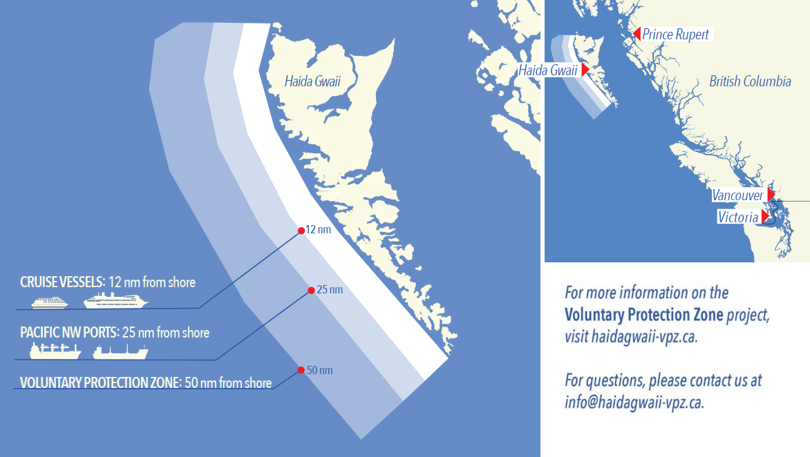
Voluntary Protection Zone for Shipping, West Coast Haida Gwaii (formerly Queen Charlotte Islands)
Haida Gwaii’s remote location, rugged coastline, variable sea
and weather conditions, and rich ecological and cultural
heritage make it vulnerable to the potential for pollution
from shipping breakdowns and accidents. Increasing the
distance vessels travel offshore can increase the amount of
time available to address propulsion, steering or other
issues, and the likelihood of a towing vessel being able to
respond to a vessel that is disabled or drifting. This in
turn reduces the risk of grounding and oil spills.
A Voluntary Protection Zone for Shipping on the West Coast of
Haida Gwaii is currently in effect. In the Voluntary
Protection Zone, commercial vessels of 500 gross tonnage or
greater shall observe a minimum distance of 50 nautical miles
offshore when transiting along the West Coast of Haida Gwaii
with the following exceptions:
–Cruise vessels, to observe a minimum 12 nm distance from shore;
–Vessels transiting between Pacific Northwest ports
(Washington, Alaska, BC), to observe a minimum 25 nm distance
from shore;
–Tugs and barges (including pushing and towing
alongside), no minimum distance; and
–Fishing vessels, no minimum distance.
The Voluntary Protection Zone for Shipping coordinates are:
|
54⁰ 15.436' N |
133⁰ 04.788' W |
|
54⁰ 17.572' N |
134⁰ 02.484' W |
|
54⁰ 13.614' N |
134⁰ 19.427' W |
|
54⁰ 11.786' N |
134⁰ 30.841' W |
|
53⁰ 44.036' N |
134⁰ 32.677' W |
|
53⁰ 11.118' N |
134⁰ 16.412' W |
|
52⁰ 18.483' N |
133⁰ 20.917' W |
|
51⁰ 24.590' N |
132⁰ 04.081' W |
|
51⁰ 56.158' N |
131⁰ 01.830' W |
Vessels are requested to adhere to these distances on a voluntary basis and only when it does not jeopardize the safety of navigation, the vessel, the persons aboard, and the cargo.
(NW-P-1085-20)
Transport Canada – Annual Edition of Notices to Mariners 2022 - Section A3, Notice 7A: Voyage Planning for Vessels Intending to Navigate in Canada's Northern Waters
(Recurrent publication of notice *206/22, originally published in the Notices to Mariners – Monthly Western Edition 02/2022 publication.)
Transport Canada has revised notice 7A, Voyage Planning for Vessels Intending to Navigate in Canada’s Northern Waters, of the Annual Edition of Notices to Mariners to reflect Arctic Shipping Safety and Pollution Prevention Regulations (ASSPPR) and to provide further guidance on voyage planning.
*402/22Canadian Hydrographic Service – Nautical Charts
|
Charts |
Main Title |
Scale |
Published |
Cat# |
Price |
|
New Charts |
|||||
|
2016 |
Charity Shoal to/à Gull Bar including / y compris Long Point |
1:60 000 |
2022-04-15 |
3 |
$20.00 |
|
New Editions |
|||||
|
7125 |
Pike-Resor Channel |
1:37 500 |
2022-04-15 |
4 |
$20.00 |
|
Charts Permanently Withdrawn |
|||||
|
2064 |
Kingston to/à False Duck Islands |
Cancelled by 2016 |
|||
*403/22Canadian Hydrographic Service – Electronic Navigational Charts
|
S-57 ENC Number |
Chart Title |
ENC Compilation Scale |
Published |
|
New Charts |
|||
|
CA471056 (Edn 1.000) |
Portland Inlet |
1:45 000 |
2022-04-08 |
|
CA471061 (Edn 1.000) |
CA471061 |
1:90 000 |
2022-04-08 |
|
CA471062 (Edn 1.000) |
CA471062 |
1:90 000 |
2022-04-08 |
|
CA471064 (Edn 1.000) |
CA471064 |
1:45 000 |
2022-04-08 |
|
CA471065 (Edn 1.000) |
CA471065 |
1:90 000 |
2022-04-08 |
|
CA471109 (Edn 1.000) |
CA471109 |
1:45 000 |
2022-04-08 |
|
CA471110 (Edn 1.000) |
CA471110 |
1:45 000 |
2022-04-08 |
|
CA471111 (Edn 1.000) |
CA471111 |
1:45 000 |
2022-04-08 |
|
CA471112 (Edn 1.000) |
CA471112 |
1:45 000 |
2022-04-08 |
|
CA471113 (Edn 1.000) |
CA471113 |
1:45 000 |
2022-04-08 |
|
CA571089 (Edn 1.000) |
Hunt Inlet |
1:12 000 |
2022-04-29 |
|
CA576586 (Edn 1.000) |
Flowers Cove |
1:7 500 |
2022-04-29 |
|
CA576707 (Edn 1.000) |
Otter Island Narrows |
1:2 500 |
2022-04-15 |
|
New Editions |
|||
|
CA273258 (Edn 7.000) |
Committee Bay - Pelly Bay |
1:250 000 |
2022-04-01 |
|
CA276274 (Edn 9.000) |
Saint-Pierre to St. John's |
1:175 000 |
2022-04-01 |
|
CA373507 (Edn 2.000) |
Parry Bay to/au Navy Channel |
1:75 000 |
2022-04-29 |
|
CA376429 (Edn 2.000) |
Corbett Island to Ship Harbour Head |
1:37 500 |
2022-04-08 |
|
CA376596 (Edn 5.000) |
Domino Point to Cape North |
1:37 500 |
2022-04-08 |
|
CA376650 (Edn 4.000) |
Cape Kiglapait to Khikkertarsoak North Island |
1:50 000 |
2022-04-08 |
|
CA376668 (Edn 3.000) |
Khikkertarsoak North Island to/à Morhardt Point |
1:50 000 |
2022-04-08 |
|
CA379026 (Edn 10.000) |
Archipel de Mingan |
1:35 000 |
2022-04-22 |
|
CA470597 (Edn 7.000) |
Grenville Channel to/à Chatham Sound |
1:20 000 |
2022-04-08 |
|
CA470624 (Edn 5.000) |
Kitkatla Channel and/et Ogden Channel |
1:20 000 |
2022-04-08 |
|
CA470659 (Edn 3.000) |
Kitkatla Channel and/et Porcher Inlet (part 2 of 2) |
1:20 000 |
2022-04-08 |
|
CA473285 (Edn 5.000) |
Bruce Mines to/à Sugar Island |
1:25 000 |
2022-04-15 |
|
CA570138 (Edn 9.000) |
Esquimalt Harbour |
1:2 500 |
2022-04-08 |
|
CA570174 (Edn 4.000) |
Malaspina Inlet, Okeover Inlet and/et Lancelot Inlet |
1:6 000 |
2022-04-15 |
|
CA570195 (Edn 9.000) |
Approaches to/Approches à Campbell River |
1:5 000 |
2022-04-01 |
|
CA573400 (Edn 3.000) |
Hall Beach |
1:5 000 |
2022-04-29 |
|
CA576269 (Edn 3.000) |
Shippegan Harbour |
1:10 000 |
2022-04-01 |
|
Charts Permanently Withdrawn |
|||
|
CA370191 |
Dixon Entrance, Eastern Portion/Partie Est |
|
|
|
CA370518 |
Portland Canal and/et Observatory Inlet |
|
|
|
CA370731 |
Bonilla Island to/à Edye Passage part 4 of 4 |
|
|
|
CA470074 |
Approaches to/Approches à Prince Rupert Harbour |
|
|
|
CA470268 |
Alice Arm |
|
|
|
CA470269 |
Nass Bay |
|
|
|
CA470283 |
Work Channel A-B |
|
|
|
CA470284 |
Work Channel B-C |
|
|
|
CA470314 |
Malacca Passage to/à Bell Passage (Part 1 of 2) |
|
|
|
CA470315 |
Malacca Passage to/à Bell Passage (Part 2 of 2) |
|
|
|
CA470363 |
Approaches to/Approches à Portland Inlet, Western Portion//Partie Ouest |
|
|
|
CA470364 |
Approaches to/Approches à Portland Inlet, Eastern Portion/Partie Est |
|
|
|
CA470369 |
Hudson Bay Passage (Western Portion, Part 1 of 2) |
|
|
|
CA470370 |
Hudson Bay Passage (Eastern Portion, Part 2 of 2) |
|
|
|
CA470523 |
Portland Inlet, Khutzeymateen Inlet and/et Pearse Canal |
|
|
|
CA476423 |
Punchbowl and Approaches/et les approches |
Cancelled by CA376429 |
|
|
CA476651 |
Okak Harbour |
Cancelled by CA376650 |
|
|
CA476670 |
Moss Harbour |
Cancelled by CA376668 |
|
|
CA476671 |
Winnie Bay |
Cancelled by CA376668 |
|
|
CA476672 |
Hebron Harbour |
Cancelled by CA376668 |
|
|
CA570234 |
Hunt Inlet |
Cancelled by CA571089, CA571085 |
|
|
CA576570 |
Flowers Cove |
Cancelled by CA576586 |
|
*404/22Canadian Hydrographic Service – Raster Digital Charts (BSB V3)
|
Charts |
Main Title |
Scale |
Published |
|
New Editions |
|||
|
RM-7125 |
Pike-Resor Channel |
1:37 500 |
2022-04-15 |
|
Charts Permanently Withdrawn |
|||
|
RM-2064 |
Kingston to/à False Duck Islands |
Cancelled by RM-2016 |
|
*405/22Transport Canada – Ship Safety Bulletins #17 and #18/2021, #07 #08, #09 and #10/2022
New and updated Ship Safety Bulletins have recently been posted on the Transport Canada website.
To view or download these bulletins, please click on the links below:
SSB#17/2021 – Measures for
Persons (other than passengers) on Canadian Vessels and
Foreign Passenger Vessels Operating in Canadian Waters to
Mitigate the Spread of COVID-19
(modified April 1,
2022)
RDIMS#
17963509
SSB#18/2021 – Measures to
Support Safe Cruise Travel in Canada (modified April 1,
2022)
RDIMS#
17917307
SSB#07/2022 – Instructions for
submitting Canadian Ballast Water Reporting form
(BWRF)
RDIMS#
18385477
SSB#08/2022 – Ukrainian
seafarers can now seek Canadian recognition of their STCW
certificates
RDIMS#
18449882
SSB#09/2022 – Protecting the
North Atlantic right whale: speed restriction measures in the
Gulf of
St. Lawrence
RDIMS#
18265176
SSB#10/2022 – New environmental
measures for cruise ships in waters under Canadian
jurisdiction – 2022
season
RDIMS#
18490623
Sign up for e-Bulletin to receive an e-mail notice each time a new Ship Safety Bulletin is published on our website.
Contact us at marinesafety-securitemaritime@tc.gc.ca or 1-855-859-3123 (Toll Free).
Section 1A: Temporary and Preliminary Notices
Reminder – Comment Period for Active Preliminary Notices
No notices applicable for this edition.
Inland Waters
No notices applicable for this edition.
Pacific Coast
No notices applicable for this edition.
SECTION 2 - CHART CORRECTIONS
3000 - Juan de Fuca Strait to/à Dixon Entrance - New Edition - 20-JAN-1989 - NAD 1927
3412 - Victoria Harbour - New Edition - 22-NOV-2013 - World Geodetic System 1984
3440 - Race Rocks to/à D'Arcy Island - New Edition - 01-JUL-2005 - NAD 1983
(See Chart No. 1, N20)
and 48°23′40.0″N 123°18′17.0″W
3443 - Thetis Island to/à Nanaimo - New Edition - 20-DEC-2002 - NAD 1983
(See Chart No. 1, K29)
3461 - Juan de Fuca Strait, Eastern Portion/Partie Est - New Edition - 01-JUL-2005 - NAD 1983
(See Chart No. 1, 2.1)
and 48°23′40.0″N 123°18′17.0″W
3462 - Juan de Fuca Strait to/à Strait of Georgia - New Edition - 01-JUL-2005 - NAD 1983
(See Chart No. 1, 2.1)
and 48°23′40.0″N 123°18′17.0″W
3538 - Desolation Sound and/et Sutil Channel - New Edition - 30-DEC-2005 - NAD 1983
(See Chart No. 1, N20)
49°58′58.0″N 124°46′13.5″W
49°58′45.8″N 124°46′06.2″W
and 49°58′41.2″N 124°45′50.8″W
3545 - Johnstone Strait, Port Neville to/à Robson Bight - New Chart - 28-APR-1989 - NAD 1983
(See Chart No. 1, I10)
(See Chart No. 1, I10)
(See Chart No. 1, I10)
(See Chart No. 1, I10)
(See Chart No. 1, I10)
(See Chart No. 1, I10)
(See Chart No. 1, I10)
(See Chart No. 1, I10)
(See Chart No. 1, I10)
(See Chart No. 1, K11)
(See Chart No. 1, I10)
(See Chart No. 1, I10)
(See Chart No. 1, I10)
3546 - Broughton Strait - New Edition - 15-APR-2005 - NAD 1983
(See Chart No. 1, I10)
(See Chart No. 1, K11)
(See Chart No. 1, I10)
(See Chart No. 1, I10)
(See Chart No. 1, I10)
(See Chart No. 1, I10)
(See Chart No. 1, K11)
(See Chart No. 1, I10)
(See Chart No. 1, I10)
(See Chart No. 1, I10)
(See Chart No. 1, I10)
(See Chart No. 1, I10)
(See Chart No. 1, K11)
(See Chart No. 1, I10)
(See Chart No. 1, I10)
(See Chart No. 1, I10)
(See Chart No. 1, I10)
(See Chart No. 1, I10)
(See Chart No. 1, K12)
Download Patch - https://www.notmar.gc.ca/chsftp/patches/3546_6204544_25_202203241106.pdf
3547 - Queen Charlotte Strait Eastern Portion/Partie Est - New Chart - 28-APR-1989 - NAD 1983
(See Chart No. 1, K11)
(See Chart No. 1, I10)
(See Chart No. 1, K11)
3554 - Lund - New Chart - 06-JAN-2017 - World Geodetic System 1984
(See Chart No. 1, N20)
49°58′58.0″N 124°46′13.5″W
49°58′45.8″N 124°46′06.2″W
and 49°58′41.2″N 124°45′50.8″W
(See Chart No. 1, Qm)
(See Chart No. 1, Qm)
(See Chart No. 1, Qm)
(See Chart No. 1, Qm)
3646 - Ucluelet Inlet - New Edition - 30-JUN-1995 - NAD 1983
(See Chart No. 1, K26)
3668 - Robbers Passage - New Edition - 07-APR-2000 - NAD 1983
(See Chart No. 1, I10)
(See Chart No. 1, I10)
3671 - Barkley Sound - New Edition - 04-NOV-2005 - NAD 1983
(See Chart No. 1, I10)
(See Chart No. 1, I10)
(See Chart No. 1, I10)
(See Chart No. 1, K11)
(See Chart No. 1, K11)
(See Chart No. 1, K11)
(See Chart No. 1, I10)
(See Chart No. 1, K26)
3811 - Port Louis and/et Otard Bay - New Edition - 16-MAR-2007 - NAD 1983
(See Chart No. 1, I10)
(See Chart No. 1, I10)
(See Chart No. 1, I10)
(See Chart No. 1, K12)
(See Chart No. 1, I10)
(See Chart No. 1, I10)
(See Chart No. 1, I10)
(See Chart No. 1, I10)
(See Chart No. 1, I10)
(See Chart No. 1, I10)
(See Chart No. 1, K11)
(See Chart No. 1, I10)
(See Chart No. 1, I10)
(See Chart No. 1, I10)
(See Chart No. 1, I10)
(See Chart No. 1, I10)
(See Chart No. 1, I10)
(See Chart No. 1, I10)
(See Chart No. 1, I10)
(See Chart No. 1, I10)
(See Chart No. 1, K11)
(See Chart No. 1, I10)
(See Chart No. 1, I10)
(See Chart No. 1, I10)
(See Chart No. 1, I10)
(See Chart No. 1, I10)
(See Chart No. 1, I10)
ATTENTION Les marins doivent être prudents en naviguant dans ces eaux puisque des hauts-fonds non cartographiés peuvent exister.
(See Chart No. 1, J9.1)
to 53°42′14.5″N 133°00′56.0″W
(See Chart No. 1, I10)
(See Chart No. 1, I10)
3868 - Port Louis to/à Langara Island - New Edition - 05-MAY-2006 - NAD 1983
(See Chart No. 1, I10)
(See Chart No. 1, I10)
(See Chart No. 1, I10)
(See Chart No. 1, I10)
(See Chart No. 1, I10)
ATTENTION De récents relevés du SHC ont établies la présence de profondeurs inférieures à celles cartographiées et indiquent que des divergences de position horizontale de l′ordre de 200 mètres peuvent exister. Les navigateurs doivent être prudents lorsqu′ils naviguent dans ces zones.
to 53°48′07.0″N 133°03′30.0″W
(See Chart No. 1, I10)
(See Chart No. 1, I10)
(See Chart No. 1, I10)
(See Chart No. 1, I10)
(See Chart No. 1, I10)
(See Chart No. 1, K11)
(See Chart No. 1, K11)
(See Chart No. 1, K11)
(See Chart No. 1, K11)
(See Chart No. 1, K11)
(See Chart No. 1, I10)
3908 - Kitimat - New Chart - 15-MAR-2013 - NAD 1983
Download Patch - https://www.notmar.gc.ca/chsftp/patches/3908_6204548_1_202203031046.pdf
3908 - Kitimat Harbour - New Chart - 15-MAR-2013 - NAD 1983
Download Patch - https://www.notmar.gc.ca/chsftp/patches/3908_6204548_2_202203031051.pdf
3909 - Welcome Harbour - New Edition - 28-APR-2017 - World Geodetic System 1984
(See Chart No. 1, K11)
(See Chart No. 1, I10)
(See Chart No. 1, I10)
(See Chart No. 1, I10)
(See Chart No. 1, I10)
(See Chart No. 1, I10)
(See Chart No. 1, I10)
3956 - Malacca Passage to/à Bell Passage - New Edition - 13-JAN-2017 - World Geodetic System 1984
(See Chart No. 1, I10)
(See Chart No. 1, I10)
(See Chart No. 1, I10)
(See Chart No. 1, I10)
(See Chart No. 1, I10)
(See Chart No. 1, I10)
(See Chart No. 1, I10)
(See Chart No. 1, I10)
(See Chart No. 1, K11)
(See Chart No. 1, I10)
(See Chart No. 1, K11)
(See Chart No. 1, I10)
(See Chart No. 1, I10)
(See Chart No. 1, I10)
(See Chart No. 1, I10)
(See Chart No. 1, I10)
3986 - Browning Entrance - New Chart - 25-DEC-2009 - NAD 1983
(See Chart No. 1, I10)
(See Chart No. 1, K12)
(See Chart No. 1, I10)
(See Chart No. 1, I10)
(See Chart No. 1, I10)
(See Chart No. 1, I10)
(See Chart No. 1, I10)
(See Chart No. 1, I10)
(See Chart No. 1, K11)
3987 - Kitkatla Channel and/et Porcher Inlet - New Chart - 25-DEC-2009 - NAD 1983
(See Chart No. 1, I10)
(See Chart No. 1, I10)
(See Chart No. 1, I10)
(See Chart No. 1, I10)
(See Chart No. 1, I10)
(See Chart No. 1, I10)
(See Chart No. 1, I10)
(See Chart No. 1, I10)
(See Chart No. 1, K11)
(See Chart No. 1, I10)
(See Chart No. 1, K11)
(See Chart No. 1, I10)
(See Chart No. 1, I10)
(See Chart No. 1, I10)
(See Chart No. 1, I10)
(See Chart No. 1, I10)
(See Chart No. 1, I10)
(See Chart No. 1, K12)
(See Chart No. 1, I10)
(See Chart No. 1, I10)
(See Chart No. 1, I10)
(See Chart No. 1, I10)
(See Chart No. 1, I10)
(See Chart No. 1, I10)
(See Chart No. 1, K11)
6105 - Rainy Lake / Lac à la Pluie - Sheet/Feuille 1 - New Edition - 21-JUN-2002 - NAD 1983
(See Chart No. 1, P1)
(See Chart No. 1, P1)
(See Chart No. 1, P16)
6421 - Hardie Island to/à Fort Good Hope Kilometre 1040 / Kilometre 1100 - New Edition - 30-MAR-2018 - World Geodetic System 1984
(See Chart No. 1, Qg)
to 66°03′42.4″N 129°07′11.4″W
(See Chart No. 1, Qg)
to 66°03′51.7″N 129°06′49.1″W
(See Chart No. 1, Qg)
to 66°04′07.3″N 129°06′14.5″W
(See Chart No. 1, Qf)
to 65°59′08.2″N 129°06′26.4″W
SECTION 3 - RADIO AIDS TO MARINE NAVIGATION CORRECTIONS
*414/22Radio Aids to Marine Navigation 2022 (Atlantic, St. Lawrence, Great Lakes, Lake Winnipeg, Arctic and Pacific)
Page 1-1
DELETE THE FOLLOWING SECTION:
1.1.1 The Radio Aids to Marine Navigation Annual Publication
Page 1-1
AMEND:
1.1.2 Marine Mammal Protection
TO READ:
1.1.1 Marine Mammal Protection
Page 1-2
AMEND:
1.1.3 Iridium SafetyCast Service
TO READ:
1.1.2 Iridium SafetyCast Service
Page 1-2
AMEND:
1.1.3.1 NAVAREAs XVII and XVIII
Effective October 1st 2020, an Iridium SafetyCast Service for broadcasting navigational warnings in the English language will be declared to be “On Trial” for Canada’s Arctic NAVAREAs XVII and XVIII.
During the Iridium SafetyCast “On Trial” phase, navigational warnings will be broadcast in accordance with the Revised Joint IMO/IHO/WMO Maritime Safety Information Manual on an intermittent and test basis. The “On Trial” phase is a test and evaluation stage which is necessary to ensure navigational warnings are processedand promulgated in a timely and appropriate manner.
NAVAREAs XVII and XVIII will broadcast Iridium SafetyCast messages to vessels with an approved SafetyCast receiver. On vessels with Iridium GMDSS terminals installed, mariners are advised to check their manufacturer’s operation manuals to obtain information on the setting of their SafetyCast receivers to receive relevant SafetyCast messages.
During this period, the Canadian Coast Guard will not guarantee service availability.
Determination when NAVAREAs XVII and XVIII are ready to declare “Operational” status will come at a later date and will be announced through a subsequent Notice to Mariners.
TO READ:
1.1.2.1 NAVAREAs XVII and XVIII
Effective May 1st 2022, the Iridium SafetyCast Service for broadcasting navigational warnings in the English language will be declared to be “Operational” for Canada’s Arctic NAVAREAs XVII and XVIII.
All navigational warnings will be broadcast in accordance with the Revised Joint IMO/IHO/WMO Maritime Safety Information Manual and promulgated in a timely and appropriate manner.
NAVAREAs XVII and XVIII will broadcast Iridium SafetyCast messages to vessels with an approved SafetyCast receiver. On vessels with Iridium GMDSS terminals installed, mariners are advised to check their manufacturer’s operation manuals to obtain information on the setting of their SafetyCast receivers to receive relevant SafetyCast messages.
Page 1-2
AMEND:
1.1.3.2 METAREAs XVII and XVIII, and the Hudson Bay Area of METAREA IV
Effective June 1st 2021, an Iridium SafetyCast Service for broadcasting of meteorological warnings, meteorological forecasts and ice information in the English language will be declared to be “On Trial” for Canada’s Arctic METAREAs XVII and XVIII, and the Hudson Bay area of METAREA IV.
During the Iridium SafetyCast “On Trial” phase, meteorological warnings, meteorological forecasts and ice information will be broadcast in accordance with the Revised Joint IMO/IHO/WMO Maritime Safety Information Manual on an intermittent and test basis. The “On Trial” phase is a test and evaluation stage which is necessary to ensure meteorological warnings, meteorological forecasts and ice information are processed and promulgated in a timely and appropriate manner.
METAREAs XVII and XVIII will broadcast Iridium SafetyCast messages, including messages for the Hudson Bay area of METAREA IV, to vessels with an approved SafetyCast receiver. On vessels with Iridium GMDSS terminals installed, mariners are advised to check their manufacturer’s operation manuals to obtain information on the setting of their SafetyCast receivers to receive relevant SafetyCast messages.
During this period, Environment and Climate Change Canada will not guarantee service availability.
Determination when METAREAs XVII and XVIII, and the Hudson Bay area of METAREA IV, are ready to declare “Operational” status will come at a later date and will be announced through a subsequent Notice to Mariners.
TO READ:
1.1.2.2 METAREAs XVII and XVIII, and the Hudson Bay Area of METAREA IV
Effective May1st 2022, the Iridium SafetyCast Service for broadcasting of meteorological warnings, meteorological forecasts and ice information in the English language will be declared to be “Operational” for Canada’s Arctic METAREAs XVII and XVIII, and the Hudson Bay area of METAREA IV.
All meteorological warnings, meteorological forecasts and ice information will be broadcast in accordance with the Revised Joint IMO/IHO/WMO Maritime Safety Information Manual and promulgated in a timely and appropriate manner.
METAREAs XVII and XVIII will broadcast Iridium SafetyCast messages, including messages for the Hudson Bay area of METAREA IV, to vessels with an approved SafetyCast receiver. On vessels with Iridium GMDSS terminals installed, mariners are advised to check their manufacturer’s operation manuals to obtain information on the setting of their SafetyCast receivers to receive relevant SafetyCast messages.
Page 1-3
AMEND:
1.1.4 DGPS
TO READ:
1.1.3 DGPS
Page 2-12
DELETE THE FOLLOWING FOR SECTION 2.1.3:
Labrador MCTS Centre VHF/DF Advisory Service
A VHF/DF Advisory Service is available to vessels within range of the receiver site located at Twillingate. Information concerning position, bearing and distance may be provided for use at the discretion of the user.
Page 2-13
DELETE AS FOLLOWS FOR SECTION 2.1.3:
Table 2-5 - Labrador MCTS/VOK - Ship/Shore Communications
|
Sites located at |
Channels |
Frequencies |
Remarks |
|
|
Transmit |
Receive |
|||
|
Twillingate
49°41'10"N |
Ch16 |
- |
- |
|
Page 2-20
AMEND AS FOLLOWS FOR SECTION 2.1.4:
Table 2-8 - Les Escoumins MCTS/VCF - Broadcasts
|
Time UTC |
Site |
Frequency or Channel |
Contents |
|
Continuous |
Lac Daigle
Grosses-Roches |
Ch21B |
Radiotelephony (French followed by English)
•Weather
for marine forecast areas 219, 301, 302, 303, 304, 305
and 313. •Notices to Fish Harvesters (when available). |
|
Mont-Louis |
Ch83B |
Pages 2-39 to 2-40
DELETE THE FOLLOWING TABLE FOR SECTION 2.1.9:
Table 2-20 - Québec MCTS/VCC - Broadcasts
REPLACE AS FOLLOWS:
Table 2-20 - Québec MCTS/VCC - Broadcasts
|
Time UTC |
Site |
Frequency or Channel |
Contents |
|
Continuous |
Lauzon
Rivière-du-Loup |
Ch21B |
Radiotelephony
•Technical
marine synopsis and marine forecasts for marine
forecast areas 303*, 305, 306, 307, 308, 309 and
314. •Seaway message. |
|
Mont Rigaud |
Ch25B |
||
|
Montmagny
Trois-Rivières |
Ch83B |
Page 5-29
AMEND:
5.10.3 Marine Weather Observations and Forecast
Bulletins
Observations available on the Environment and Climate Change
Canada Weatheradio network are updated hourly and include a
series of coastal stations extending around the coast of
Newfoundland and Labrador to the Maritimes and into the Gulf of
St. Lawrence, as well as offshore buoys when available. Marine
forecast bulletins are updated at regular intervals or whenever
necessary. These bulletins are available on MSC’s Automated
Telephone Answering Device (ATAD), as well as Weatheradio and
CCG’s Continuous Marine Broadcast (CMB).
TO READ:
5.10.3 Marine Weather Observations and Forecast
Bulletins
As of November 15 2021, observations and forecast bulletins are
available on MSC’s Hello Weather Service at 1-833-79HELLO
(1-833-794-3556). Hello Weather has replaced MSC's Automated
Telephone Answering Device (ATAD). Observations and forecast
bulletins are also available on Weatheradio and the CCG’s
continuous marine broadcast (CMB). Observations are updated
hourly and include a series of coastal stations extending
around the coast of Newfoundland and Labrador to the Maritimes
and into the Gulf of St. Lawrence, as well as offshore buoys
when available. Marine forecast bulletins are updated at
regular intervals or whenever necessary.
Page 5-34
AMEND AS FOLLOWS:
5.11.4 Marine Weather Observations and Forecast Bulletins
As of November 15 2021, observations and forecast bulletins
will be are available on MSC’s Hello
Weather Service at 1-833-79HELLO (1-833-794-3556). Hello
Weather will replace
has replaced MSC’s Automated Telephone
Answering Device (ATAD). Observations and forecast bulletins
are also available on Weatheradio and the CCG’s continuous
marine broadcast. Observations are updated hourly and include a
series of coastal stations extending from the coast of Maine
around the Maritimes and into the Gulf of St. Lawrence, as well
as offshore buoys. Marine forecast bulletins are updated at
regular intervals or whenever necessary.
Page 5-38
AMEND:
5.12.4 Marine Weather Observations and Forecast Bulletins
Environment and Climate Change Canada operates a network of coastal and insular weather observing stations as well as one weather buoy. Hourly weather reports from these stations are available continuously on Environment and Climate Change Canada’s Weatheradio (see Weatheradio Canada below) and on request from the CCG MCTS Centres (refer to Marine Weather Observations). Marine forecasts are updated at regular intervals or whenever necessary and are available on Weatheradio and CCG’s continuous marine broadcast.
TO READ:
5.12.4 Marine Weather Observations and Forecast Bulletins
As of November 15 2021, observations and forecast bulletins are available on MSC’s Hello Weather Service at 1-833-79HELLO (1-833-794-3556). Hello Weather has replaced MSC's Automated Telephone Answering Device (ATAD). Observations and forecast bulletins are also available on Weatheradio and the CCG’s continuous marine broadcast (CMB). Observations are updated hourly and include a series of coastal stations along the St. Lawrence River. Marine forecast bulletins are updated at regular intervals or whenever necessary.
Page 5-42
ADD THE FOLLOWING NEW SECTION 5.13.5:
5.13.5 Marine Weather Observations and Forecast Bulletins
As of November 15 2021, observations and forecast bulletins are available on MSC’s Hello Weather Service at 1-833-79HELLO (1-833-794-3556). Hello Weather has replaced MSC's Automated Telephone Answering Device (ATAD).”
Page 5-42
AMEND:
5.13.5 Weatheradio Canada
TO READ:
5.13.6 Weatheradio Canada
Page 5-43
AMEND:
5.13.6 Marine Forecast Areas
TO READ:
5.13.7 Marine Forecast Areas
Page 5-44
AMEND AS FOLLOWS:
5.14.2 Marine Weather Observations and Forecast Bulletins
Local weather observations are available for several stations
including lighthouses, ocean buoys, automatic weather reporting
stations and other stations of the regular weather network. The
broadcast listing provides more information on available
stations and broadcast times. Marine forecast bulletins are
updated at regular intervals or whenever necessary. Starting
November 15 2021, observations and forecast bulletins will be are available on MSC’s Hello
Weather Service at 1-833-79HELLO (1-833-794-3556). Hello
Weather will replace
has replaced MSC's
Automated Telephone Answering Device (ATAD). Observations and
forecast bulletins are also available on Weatheradio and CCG's
continuous marine broadcast.
SECTION 4 - SAILING DIRECTIONS AND SMALL CRAFT GUIDE CORRECTIONS
NO CORRECTIONS FOR THIS SECTION.
SECTION 5 - LIST OF LIGHTS, BUOYS AND FOG SIGNALS CORRECTIONS
NO CORRECTIONS FOR THIS SECTION.
Report a problem on this page
- Date modified: