
Archived information
The Standard on Web Usability replaces this content. This content is archived because Common Look and Feel 2.0 Standards have been rescinded.
Archived information is provided for reference, research or recordkeeping purposes. It is not subject to the Government of Canada Web Standards and has not been altered or updated since it was archived.
NOTICES TO MARINERS
PUBLICATION
EASTERN EDITION
November 27, 2020

Safety First, Service Always
Published Monthly by the
CANADIAN COAST GUARD
www.notmar.gc.ca/subscribe/
CONTENTS
| Section 1 | General and Safety Information |
| Section 2 | Chart Corrections |
| Section 3 | Radio Aids to Marine Navigation Corrections |
| Section 4 | Sailing Directions and Small Craft Guide Corrections |
| Section 5 | List of Lights, Buoys and Fog Signals Corrections |
Canadian Coast Guard Programs
Aids to Navigation and Waterways
Fisheries and Oceans Canada
Montreal, Quebec
H2Y 2E7
© Her Majesty the Queen in Right of Canada, 2020
Fs152-6E-PDF
ISSN 1719-7708
Disponible en français :
Publication des Avis aux navigateurs
Édition de l'Est
Édition mensuelle Nº11/2020
Fisheries and Oceans Canada
Official Publication of the Canadian Coast Guard
EXPLANATORY NOTES
Geographical positions refer directly to the graduations of the largest scale Canadian Hydrographic Service chart unless otherwise indicated.
Bearings refer to the true compass and are measured clockwise from 000° (North) clockwise to 359°; those relating to lights are from seaward.
Visibility of lights is that in clear weather.
Depths - The units used for soundings (metres, fathoms or feet) are stated in the title of each chart.
Elevations are normally given above Higher High Water, Large Tide unless otherwise indicated.
Distances may be calculated as follows:
1 nautical mile = 1,852 metres (6,076.1 feet)
1 statute mile = 1,609.3 metres (5,280 feet)
1 metre = 3.28 feet
Temporary and Preliminary Notices to Mariners are indicated by a (T) or a (P) in Section 1, respectively. Please note that nautical charts are not amended by the Canadian Hydrographic Service for temporary (T) and preliminary (P) notices. It is recommended that mariners chart these corrections in pencil. For the list of charts affected by (T) & (P) notices, please refer to the index on page ii of the current Monthly Summary of (T) and (P) Notices publication.
Please note that, in addition to the temporary and preliminary changes normally advertised as (T) & (P) notices, there are a few permanent changes to aids to navigation that have been advertised as preliminary Notices to Mariners while charts are being updated for new editions.
Marine Information Report & Suggestion Sheet
Mariners are requested to notify the responsible authorities when new or suspected dangers to navigation are discovered, changes observed in aids to navigation or corrections to publications are seen
to be necessary. Such communications can be made using the Marine Information Report & Suggestion Sheet inserted on the last
page of each monthly edition of Notices to Mariners.
Canadian Hydrographic Service (CHS) - Information Published in Section 2 of Notices to Mariners
Mariners are advised that only the most critical changes that directly affect safety to navigation are issued in Section 2 – Chart Corrections. This limitation
is required to ensure that charts remain as clear and easy to read as possible. As a result, mariners may see minor discrepancies of a
non-critical nature between information in official publications. For example, a small change in the nominal range or focal height of a light
may not result in the production of a chart correction in Notices to Mariners, but may result in a correction in the List of Lights, Buoys and
Fog Signals publication.
In the case of a discrepancy between information provided on CHS charts relating to aids to navigation, and the List of Lights, Buoys and Fog Signals publication, the latter shall be deemed as containing the most up-to-date information.
Canadian Nautical Charts & Publications
A source list of Canadian nautical charts and publications is published in Notice No. 14 of the Notices to Mariners Annual Edition 2020. The source supply and the prices
effective at the time of printing are listed. For current chart edition dates, please refer to the following website:
www.chs-shc.gc.ca/charts-cartes/paper-papier/index-eng.asp
CHART CORRECTIONS - SECTION 2
Corrections to nautical charts will be listed in numerical order by chart number. Each chart correction listed applies only to that particular chart. Related charts, if any, will have their own specific correction listed separately.
Users should also refer to CHS Chart 1: Symbols, Abbreviations and Terms for additional information pertaining to the correction of charts.
The illustration below describes the elements that will comprise a typical Section 2 chart correction:

The last correction number is identified with the LNM/D or Last Notice to Mariners Number / Date.
NOTICES TO MARINERS WEBSITE – MONTHLY EDITIONS, CHART CORRECTIONS, AND CHART PATCHES
The Notices to Mariners website allows users to access the monthly publications,
chart corrections, and chart patches.
Users can subscribe for free to the email notification service
to receive notifications when charts of interest are updated, including their patches, as well as when a new monthly edition becomes available online.
In addition, the monthly publication and related files to download, such as chart patches and Sailing Directions diagrams, can be obtained all together through the download of a single ZIP file.
ADVISORY NAVIGATIONAL WARNINGS / NOTICES TO SHIPPING
The Canadian Coast Guard is implementing a number of changes to the aids to navigation system in Canada.
These changes are advertised as Navigational Warnings, formerly called Notices to ShippingFootnote 1, that are broadcast by the Canadian Coast Guard, and are then followed up with Notices to Mariners, then charts are updated by hand correction, reprints or new editions.
Mariners are advised that all relevant Navigational Warnings (NAVWARNs) should be kept until superseded by Notices to Mariners or through revised charts issued by the Canadian Hydrographic Service (CHS).
Navigational Warnings are accessible on the applicable regional page on the Canadian Coast Guard e-Navigation Maritime Information Portal at http://www.marinfo.gc.ca/e-nav.
The Canadian Hydrographic Service is reviewing the impact of these changes with the Canadian Coast Guard and together are preparing an action plan on the issuing of chart revisions.
For further information, contact your regional Navigational Warning (NAVWARN) Issuing Desk.
Atlantic Region
* Port aux Basques MCTS Centre
Canadian Coast Guard
49 Stadium Rd.
P.O. Box 99
Port aux Basques, NL A0M 1C0
Telephone: (709) 695-2168 or 1-800-563-9089
Facsimile: (709) 695-7784
Email: NAVWARN.MCTSPortAuxBasques@innav.gc.ca
Website: http://www.marinfo.gc.ca/e-nav
Central Region
* Prescott MCTS Centre
Canadian Coast Guard
401 King Street West
P.O. Box 1000
Prescott, ON K0E 1T0
“C” and “Q” Series
Telephone: (613) 925-0666
Facsimile: (613) 925-4519
Email: NAVWARN.MCTSPrescott@innav.gc.ca
Website: http://www.marinfo.gc.ca/e-nav
* Sydney MCTS Centre
Canadian Coast Guard
1190 Westmount Road
Sydney, NS B1R 2J6
Telephone: (902) 564-7751 or 1-800-686-8676
Facsimile: (902) 564-7662
Email: NAVWARN.MCTSSydney@innav.gc.ca
Website: http://www.marinfo.gc.ca/e-nav
Arctic Region
* Iqaluit MCTS Centre
Operational from approximately mid-May until late December.
Canadian Coast Guard
P.O. Box 189
Iqaluit, NU X0A 0H0
“A” Series
Telephone: (867) 979-5269
“H” Series
Telephone: (867) 979-0310
Facsimile: (867) 979-4264
Email: NAVWARN.MCTSIqaluit@innav.gc.ca
Website: http://www.marinfo.gc.ca/e-nav
* Service available in English and French.
Index
NUMERICAL INDEX OF CANADIAN CHARTS AFFECTED
This numerical index lists all nautical charts mentioned in this monthly edition of Notices to Mariners. Only charts appearing in Section 2 of this publication require a chart correction. The appearance of charts in all other sections, particularly those related to the correction of other nautical publications, is included here for reference.
| 1202 | 2028 | 4615 | 4955 |
| 1230 | 2181 | 4653 | 4956 |
| 1236 | 4023 | 4700 | 4957 |
| 1310 | 4026 | 4725 | 5030 |
| 1311 | 4277 | 4847 | 5055 |
| 1312 | 4301 | 4863 | 5135 |
| 1313 | 4302 | 4905 | 6105 |
| 1315 | 4335 | 4909 | 6108 |
| 1317 | 4394 | 4913 | 7125 |
| 1351 | 4403 | 4920 | 7739 |
| 1438 | 4446 | 4938 | 8046 |
| 1439 | 4486 | 4954 | 8047 |
SECTION 1 - GENERAL AND SAFETY INFORMATION
TRANSPORT CANADA – RESTRICTED SPEED AREA - ST. CLAIR AND DETROIT RIVERS
(Recurrent publication of notice *1103/12, originally published in the Notices to Mariners Publication - Eastern Edition 11/2012.)
Since November 14, 2012, the restricted speed area currently in place as per the St. Clair and Detroit River Navigation Safety Regulations between the Detroit River light and Peche Island light is reduced in size by relocating the southern point of the restricted speed area from its current location at the Detroit River light to a new location at Bar Point light D33.
CANADIAN COAST GUARD PUBLICATION – COMMENTS AND SUGGESTIONS ON NOTICES TO MARINERS (NOTMAR) PUBLICATIONS
In an effort to continuously improve the Notices to Mariners publications and to provide the most efficient service possible, the Notices to Mariners team invites all mariners and other interested parties to submit comments and suggestions on possible improvements to its various publications and services at the following email address: Notmar.XNCR@dfo-mpo.gc.ca
CANADIAN HYDROGRAPHIC SERVICE – MODIFICATIONS TO THE 2020 CANADIAN TIDE AND CURRENT TABLES VOLUME 1 – ATLANTIC COAST AND BAY OF FUNDY
(Recurrent publication of notice *203/20, originally published in the Notices to Mariners Publication - Eastern Edition 02/2020.)
The Canadian Hydrographic Service of the Atlantic Region has identified an error in the 2020 Canadian Tide and Current Tables Volume 1 - Atlantic Coast and Bay of Fundy, Tide tables for Holyrood, Newfoundland (station #925)
Mariners must refer to the following link for updated information on Holyrood's Tide Tables:
TRANSPORT CANADA – COVID-19 MEASURES, UPDATES AND GUIDANCE
(Recurrent publication of notice *401/20, originally published in the Notices to Mariners Publication - Eastern Edition 04/2020.)
Please refer to the link below for the latest updates to transportation related measures taken by Transport Canada in response to the evolving novel Coronavirus disease (COVID-19):
https://www.tc.gc.ca/en/initiatives/covid-19-measures-updates-guidance-tc.html
For travel advice and all other updates, please visit: Canada.ca/coronavirus
CANADIAN HYDROGRAPHIC SERVICE – MODIFICATIONS TO THE 2020 CANADIAN TIDE AND CURRENT TABLES, VOLUME 2 – GULF OF ST. LAWRENCE
(Recurrent publication of notice *506/20, originally published in the Notices to Mariners Publication - Eastern Edition 05/2020.)
The Canadian Hydrographic Service of the Quebec Region has identified a correction in the 2020 Canadian Tide and Current Tables, Volume 2, Gulf of St. Lawrence, on page 79.
Mariners should replace a section of Table 3 with the corresponding section annexed below:
https://www.notmar.gc.ca/publications/monthly-mensuel/images/ed052020-part1-vol2-p79.pdf
CANADIAN HYDROGRAPHIC SERVICE – CANADIAN TIDE AND CURRENT TABLES – PRINTING TO BE DISCONTINUED
(Recurrent publication of notice *904/20, originally published in the Notices to Mariners Publication - Eastern Edition 09/2020.)
Due to the availability of the Canadian Tide and Current Tables as viewable and printable PDF files on charts.gc.ca for each complete volume and additional information in different formats (predictions, observations in tables, and graphics) on tides.gc.ca, the Canadian Hydrographic Service is permanently discontinuing the printing of all volumes of Canadian Tide and Current Tables starting January 2021.
Advances in technology bring a new era of marine navigation with a focus on digital and electronic products. The Canadian Hydrographic Service is transforming the way it delivers quality data and services to clients, in a timely manner, to support decision-making.
For more information, visit www.charts.gc.ca.
CANADIAN HYDROGRAPHIC SERVICE – CHART 1 – PRINTING TO BE DISCONTINUED
(Recurrent publication of notice *905/20, originally published in the Notices to Mariners Publication - Eastern Edition 09/2020.)
Due to the availability of Chart 1: Symbols, Abbreviations and Terms as both viewable and printable PDF files and HTML format on charts.gc.ca, the Canadian Hydrographic Service is permanently discontinuing the printing of Chart 1: Symbols, Abbreviations and Terms starting January 2021.
Advances in technology bring a new era of marine navigation with a focus on digital and electronic products. The Canadian Hydrographic Service is transforming the way it delivers quality data and services to clients, in a timely manner, to support decision-making.
For more information, visit www.charts.gc.ca.
CANADIAN HYDROGRAPHIC SERVICE – NOTICES TO MARINERS FOR CHANGES IN BUOY SHAPE
(Recurrent publication of notice *906/20, originally published in the Notices to Mariners Publication - Eastern Edition 09/2020.)
As part of the CHS Digital Transformation and for the sake of economy, CHS will no longer systematically issue Notices to Mariners (NTM) for buoy shape changes only. These changes will, however, be applied to electronic navigation charts (ENCs) where applicable. The paper and raster versions will be updated during the New Edition process.
*1101CANADIAN HYDROGRAPHIC SERVICE – NAUTICAL CHARTS
|
CHARTS |
MAIN TITLE |
SCALE |
PUBLISHED |
CAT# |
PRICE |
|
New Editions |
|
|
|
|
|
|
1202 |
Cap Éternité à/to Saint Fulgence |
1:37 500 |
23-OCT-2020 |
1 |
20.00 |
|
1439 |
Carleton Island to/au Charity Shoal |
1:30 000 |
30-SEP-2020 |
3 |
20.00 |
|
7125 |
Pike-Resor Channel |
1:37 500 |
02-OCT-2020 |
4 |
20.00 |
|
7739 |
James Ross Strait |
1:80 000 |
09-OCT-2020 |
4 |
20.00 |
|
Charts Permanently Withdrawn |
|||||
|
4725 |
Carrington Island to / à Etagaulet Bay |
||||
*1102CANADIAN HYDROGRAPHIC SERVICE – RASTER DIGITAL CHARTS (BSB V3)
|
CHARTS |
MAIN TITLE |
SCALE |
PUBLISHED |
|
New Editions |
|
|
|
|
RM-1202 |
Cap Éternité à/to Saint Fulgence |
1:37 500 |
23-OCT-2020 |
|
RM-1439 |
Carleton Island to/au Charity Shoal |
1:30 000 |
30-SEP-2020 |
|
RM-7125 |
Pike-Resor Channel |
1:37 500 |
02-OCT-2020 |
|
RM-7739 |
James Ross Strait |
1:80 000 |
09-OCT-2020 |
|
Charts Permanently Withdrawn |
|||
|
RM-4725 |
Carrington Island to / à Etagaulet Bay |
||
*1103TRANSPORT CANADA – SHIP SAFETY BULLETIN #23/2020
A new Ship Safety Bulletin has recently been posted on the Transport Canada website at www.tc.gc.ca/ssb-bsn/.
To view or download this bulletin, please click on the link below:
SSB#23/2020 – New navigation
safety
regulations
RDIMS#16889859
Sign up for e-Bulletin to receive an e-mail notice each time a new Ship Safety Bulletin is published on our website.
Contact us at marinesafety-securitemaritime@tc.gc.ca or 1-855-859-3123 (Toll Free).
*1104ANTIGONISH HARBOUR – UNLIT BUOY REPOSITIONED
Reference Chart: 4446
The following unlit buoy has been repositioned to the following coordinates:
|
Antigonish Harbour buoy VS5 |
(LL 5889.9): |
45° 41’ 31.7”N 061° 53’ 15.5”W |
(G2020-259)
*1105(P)LAHAVE RIVER: WEST IRONBOUND ISLAND TO / À RIVERPORT – FOG HORN TO BE DISCONTINUED
Reference Chart: 4394
The Canadian Coast Guard proposes to permanently discontinue the fog horn of the following aid to navigation:
|
Moshers Island |
(LL 423) |
(44° 14’ 14.6”N 064° 18’ 59.1”W) |
The light and structure will remain. |
Comments on this action are solicited from mariners and other interested parties by February 26, 2021, three months following the initial publication date of November 27, 2020. Following this date, this notice will be cancelled. Comments should be directed to the following:
Superintendent, Aids to Navigation
Canadian Coast Guard
P.O. Box 1236
Charlottetown, PE C1A 7M8
Telephone: (902) 566-7936
Email: claire.maclaren@dfo-mpo.gc.ca
Any objections raised must state the facts on which they are based and should include supporting information on safety, commerce and public benefit.
(F2020-048)
*1106(P)PICTOU HARBOUR AND EAST RIVER OF PICTOU – LIGHT TO BE DISCONTINUED
Reference Chart: 4938
The Canadian Coast Guard proposes to permanently discontinue the following aid to navigation:
|
Pictou |
(LL 906) |
(45° 40’ 37.6”N 062° 42’ 08.8”W) |
Comments on this action are solicited from mariners and other interested parties by February 26, 2021, three months following the initial publication date of November 27, 2020. Following this date, this notice will be cancelled. Comments should be directed to the following:
Superintendent, Aids to Navigation
Canadian Coast Guard
P.O. Box 1236
Charlottetown, PE C1A 7M8
Telephone: (902) 566-7936
Email: claire.maclaren@dfo-mpo.gc.ca
Any objections raised must state the facts on which they are based and should include supporting information on safety, commerce and public benefit.
(G2020-260P)
*1107(P)GREEN BAY TO / À DOUBLE ISLAND – FOG HORN TO BE DISCONTINUED
Reference Chart: 5030
The Canadian Coast Guard proposes to permanently discontinue the fog horn of the following aid to navigation:
|
Camp Islands |
(LL 279) |
(52° 10’ 00.7”N 055° 38’ 24.8”W) |
The light and structure will remain. |
Comments on this action are solicited from mariners and other interested parties by February 26, 2021, three months following the initial publication date of November 27, 2020. Following this date, this notice will be cancelled. Comments should be directed to the following:
Superintendent, Aids to Navigation
Canadian Coast Guard
P.O. Box 1236
Charlottetown, PE C1A 7M8
Telephone: (902) 566-7936
Email: claire.maclaren@dfo-mpo.gc.ca
Any objections raised must state the facts on which they are based and should include supporting information on safety, commerce and public benefit.
(N2020-096)
SECTION 2 - CHART CORRECTIONS
1236 - Pointe des Monts aux/to Escoumins - New Edition - 26-OCT-2012 - NAD 1983
(See Chart No. 1, I10)
(See Chart No. 1, I10)
(See Chart No. 1, I10)
1351 - Chambly Écluses/Locks 1,2,3 - Sheet/Feuille 1 - New Edition - 18-NOV-2016 - NAD 1983
(See Chart No. 1, I10)
(See Chart No. 1, I10)
(See Chart No. 1, I10)
(See Chart No. 1, I10)
(See Chart No. 1, I10)
(See Chart No. 1, I10)
1438 - Grindstone Island to/à Carleton Island - New Edition - 31-AUG-2012 - World Geodetic System 1984
2028 - Cook's Bay and/et Holland River - Sheet/Feuille 3 - New Edition - 15-JUN-2007 - NAD 1983
(See Chart No. 1, P1)
(See Chart No. 1, Qg)
2028 - Maskinonge River Entrance/Entrée de la Maskinonge River - Sheet/Feuille 3 - New Edition - 15-JUN-2007 - NAD 1983
(See Chart No. 1, P1)
(See Chart No. 1, Qg)
2181 - Port Stanley - New Edition - 11-MAY-2007 - NAD 1983
4023 - Northumberland Strait / Détroit de Northumberland - New Edition - 27-DEC-2002 - NAD 1983
(See Chart No. 1, P1)
4026 - Havre Saint-Pierre et/and Cap des Rosiers à/to Pointe des Monts - New Edition - 23-MAY-2014 - NAD 1983
(See Chart No. 1, I10)
(See Chart No. 1, I10)
4277 - Entrance to/Entrée à Great Bras D'Or - New Edition - 29-DEC-2017 - NAD 1983
(See Chart No. 1, P16)
4277 - Great Bras D'Or, St. Andrews Channel and/et St. Anns Bay - New Edition - 29-DEC-2017 - NAD 1983
(See Chart No. 1, P16)
4301 - Canso Harbour to Strait of Canso - New Chart - 31-MAY-2019 - World Geodetic System 1984
(See Chart No. 1, P46)
4302 - Strait of Canso - New Chart - 28-SEP-2012 - NAD 1983
(See Chart No. 1, P46)
4335 - Strait of Canso and Approaches / et les approches - New Edition - 04-JAN-2008 - NAD 1983
(See Chart No. 1, P1)
4403 - East Point to / à Cape Bear - New Edition - 04-APR-2003 - NAD 1983
(See Chart No. 1, P40.1)
4486 - Baie des Chaleurs / Chaleur Bay - New Edition - 19-FEB-1999 - NAD 1983
(See Chart No. 1, Qf)
and 47°38′51.2″N 064°46′30.4″W
4615 - Harbours in Placentia Bay / Havres dans Placentia Bay: Petit forte to / à Broad Cove Head - New Edition - 20-AUG-1999 - NAD 1983
(See Chart No. 1, F14)
and 47°24′18.2″N 054°39′34.2″W
(See Chart No. 1, I10)
(See Chart No. 1, F4.1)
and 47°24′13.2″N 054°39′33.3″W
(See Chart No. 1, I15)
(See Chart No. 1, I10)
(See Chart No. 1, I15)
4653 - Little Port - New Edition - 30-MAY-2003 - NAD 1983
(See Chart No. 1, Qg)
4700 - Belle Isle to / à Resolution Island - New Edition - 21-MAR-2003 - Unknown
(See Chart No. 1, P16)
4847 - Conception Bay - New Edition - 03-AUG-2001 - NAD 1983
(See Chart No. 1, Q130.4)
4863 - Bacalhao Island to / à Black Island - New Edition - 30-NOV-2001 - NAD 1983
(See Chart No. 1, Qf)
4909 - Richibucto Harbour - New Chart - 17-JUN-1988 - NAD 1983
(See Chart No. 1, Qf)
and 46°42′44.2″N 064°44′59.6″W
4920 - Bathurst Harbour - New Edition - 14-DEC-2018 - NAD 1983
(See Chart No. 1, Qf)
4954 - Chenal du Havre de la Grande Entrée - New Edition - 18-MAR-2016 - NAD 1983
4955 - Havre-aux-Maisons - New Edition - 15-JUN-2018 - NAD 1983
4956 - Cap-aux-Meules - New Edition - 02-SEP-2011 - NAD 1983
4957 - Havre-Aubert - New Edition - 02-JAN-2015 - NAD 1983
5135 - Approaches to / Approches À Hamilton Inlet - New Edition - 12-JUL-2002 - NAD 1983
(See Chart No. 1, Q130.3)
6105 - Rainy Lake / Lac à la Pluie - Sheet/Feuille 1 - New Edition - 21-JUN-2002 - NAD 1983
(See Chart No. 1, P1)
(See Chart No. 1, Qf)
(See Chart No. 1, Qg)
6108 - Fort Frances to/à Hostess Island and/et Sandpoint Island - New Edition - 10-NOV-2000 - NAD 1983
(See Chart No. 1, P1)
(See Chart No. 1, Qf)
(See Chart No. 1, Qg)
8046 - Button Islands to / à Cod Island - New Edition - 23-MAY-2003 - Unknown
(See Chart No. 1, P16)
8047 - Cod Island to / à Cape Harrison - New Edition - 23-MAY-2003 - Unknown
(See Chart No. 1, P16)
SECTION 3 - RADIO AIDS TO MARINE NAVIGATION CORRECTIONS
*1108RADIO AIDS TO MARINE NAVIGATION 2020 (ATLANTIC, ST. LAWRENCE, GREAT LAKES, LAKE WINNIPEG, ARCTIC AND PACIFIC)
Page 1-2
ADD THE FOLLOWING SECTION:
1.1.3Iridium SafetyCast Service
The International
Maritime Organization (IMO) and the International
Hydrographic Organization (IHO) announced the
establishment of the Iridium SafetyCast Service as a
recognized mobile satellite service in the Global
Maritime Distress and Safety System (GMDSS).
Effective October
1st 2020, an Iridium SafetyCast
Service for broadcasting navigational warnings in the
English language will be declared to be in an “Initial
Operational Capability” (IOC) for Canada’s Arctic
NAVAREAs XVII and XVIII.
During the Iridium
SafetyCast IOC period, navigational warnings will be
broadcast in accordance with the Revised Joint
IMO/IHO/WMO Maritime Safety Information Manual on an
intermittent and test basis. The IOC period is a test
and evaluation stage which is necessary to ensure
navigational warnings are processed and promulgated in
a timely and appropriate manner. NAVAREAs XVII and
XVIII will broadcast Iridium SafetyCast messages to
vessels with an approved SafetyCast receiver. On
vessels with Iridium GMDSS terminals installed,
mariners are advised to check their manufacturer’s
operation manuals to obtain information on the setting
of their SafetyCast receivers to receive relevant
SafetyCast messages.
During this period,
the Canadian Coast Guard will not guarantee service
availability.
Determination when
NAVAREAs XVII and XVIII is ready to establish "Full
Operational Capability" (FOC) will come at a later date
and will be announced through a subsequent Notice to
Mariners.
SECTION 4 - SAILING DIRECTIONS AND SMALL CRAFT GUIDE CORRECTIONS
ATL 108 — Gulf of St. Lawrence (Southwest Portion), First Edition, 2006 —
Chapter 1 —Paragraph 114
Delete: “A sector light (948.3) … indicates the preferred channel.”
(A2020-008.17)
Chapter 1 —Adjacent to paragraph 114, delete the light pictograph.
(A2020-008.18)
Chapter 4 —Paragraph 79
Delete: square skeleton tower
Replace by: pipe swing pole
(A2020-008.19)
Chapter 4 —Paragraph 270
Delete: “A light (1352.2) … outer end of the wharf.”
(A2020-008.20)
Chapter 4 —Adjacent to paragraph 270, delete the light pictograph.
(A2020-008.21)
Chapter 2 — In the vicinity of paragraph 48
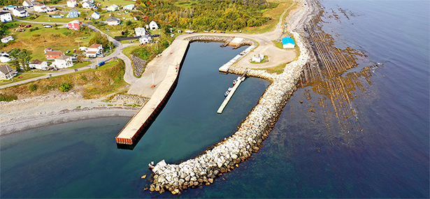
Delete the photograph of L’ANSE-À-VALLEAU (2010) and
replace it with the new L’ANSE-À-VALLEAU (2020)
photograph provided in Section 4 of this Monthly
Edition.
https://www.notmar.gc.ca/publications/monthly-mensuel/images/ed112020-part4-atl110-lanse-a-valleau.jpg
(Q2020-041.1)
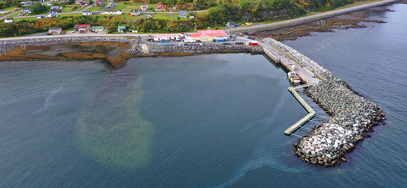
Chapter 2 — In the vicinity of paragraph 83
Delete the photograph of MONT-LOUIS (2010) and replace
it with the new MONT-LOUIS (2020) photograph provided in
Section 4 of this Monthly Edition.
https://www.notmar.gc.ca/publications/monthly-mensuel/images/ed112020-part4-atl110-mont-louis.jpg
(Q2020-041.2)
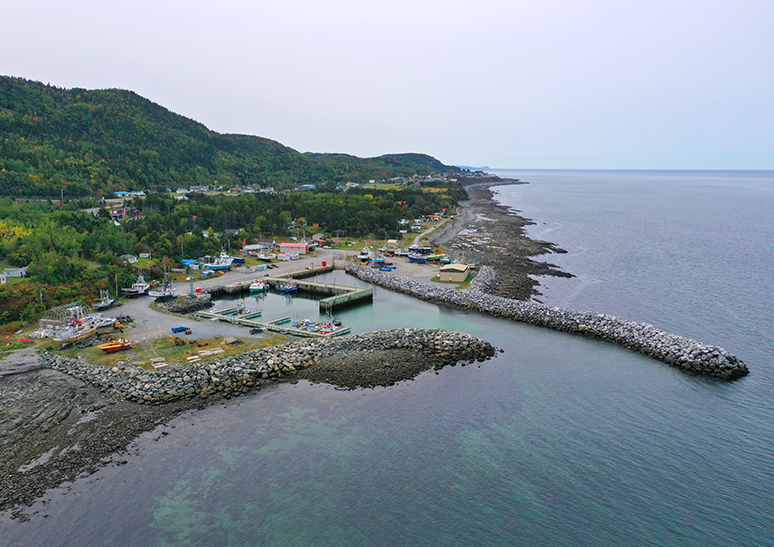
Chapter 2 — In the vicinity of paragraph 103
Delete the photograph of PETITE-TOURELLE (2010) and
replace it with the new PETITE-TOURELLE
(2020) photograph provided in Section 4
of this Monthly Edition.
https://www.notmar.gc.ca/publications/monthly-mensuel/images/ed112020-part4-atl110-petite-tourelle.jpg
(Q2020-041.3)
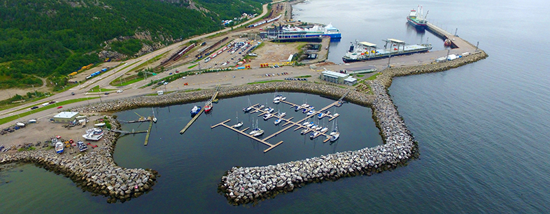
Chapter 2 — In the vicinity of paragraph 123
Delete the photograph of LES MÉCHINS (2010) and replace
it with the new LES MÉCHINS (2020) photograph provided
in Section 4 of this Monthly Edition.
https://www.notmar.gc.ca/publications/monthly-mensuel/images/ed112020-part4-atl110-les-mechins.jpg
(Q2020-041.4)
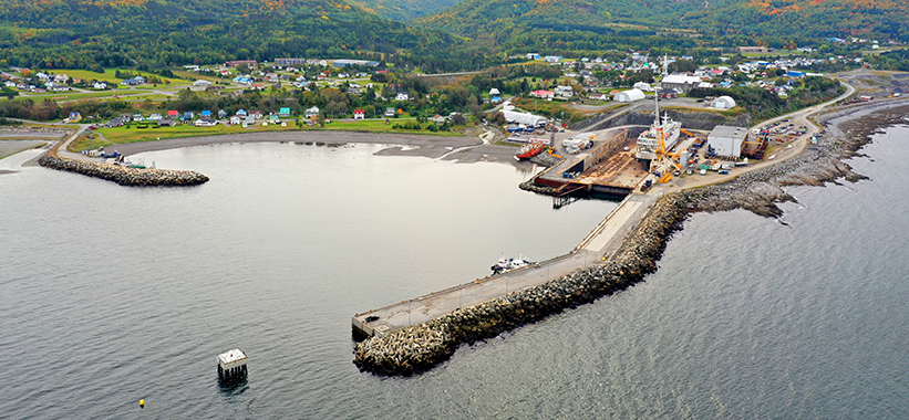
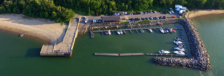
Chapter 3 — In the vicinity of paragraph 66
Delete the photograph of BAIE-COMEAU MARINA (2009) and
replace it with the new BAIE-COMEAU MARINA
(2020) photograph provided in Section 4
of this Monthly Edition.
https://www.notmar.gc.ca/publications/monthly-mensuel/images/ed112020-part4-atl110-port-de-plaisance-a-baie-comeau.jpg
(Q2020-041.5)
Chapter 3 — In the vicinity of paragraph 127
Delete the photograph of LES ESCOUMINS PILOT STATION
(2009) and replace it with the new LES ESCOUMINS PILOT
STATION (2014) photograph provided in Section 4
of this Monthly Edition.
https://www.notmar.gc.ca/publications/monthly-mensuel/images/ed112020-part4-atl110-station-de-pilotage-des-escoumins.jpg
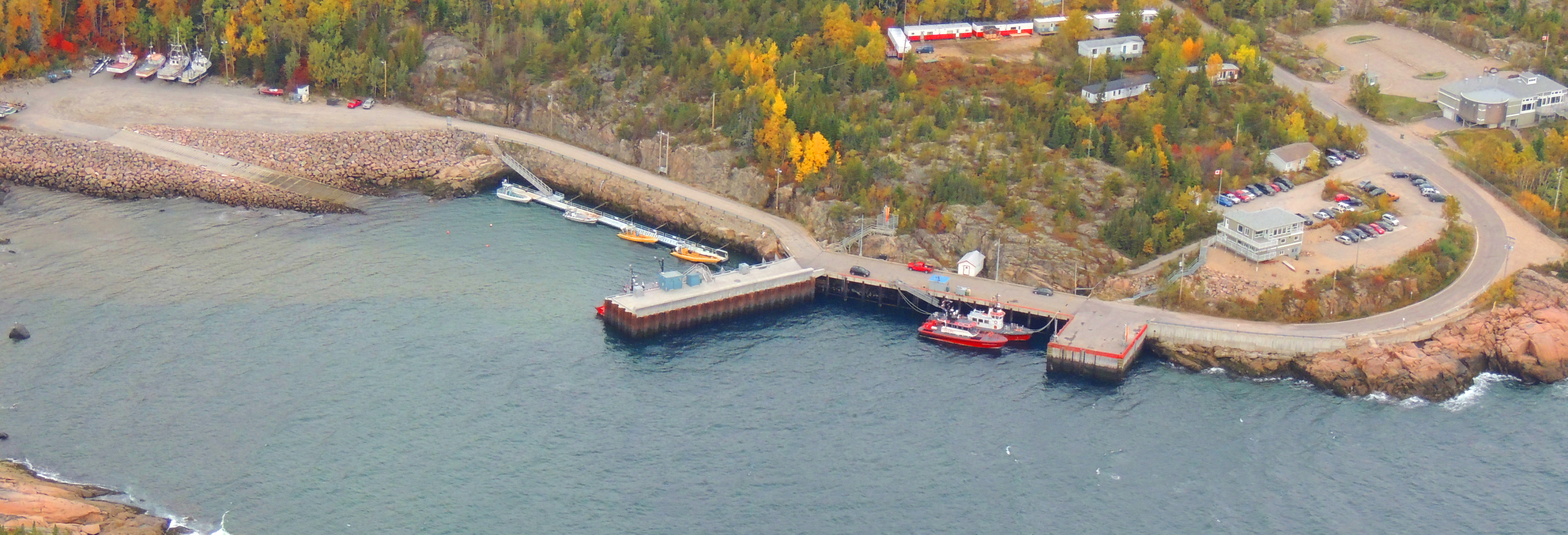
(Q2020-041.6)
Chapter 3 — Paragraph 174
Delete: wharf in ruins, almost completely
Replace by: wharf,
(Q2020-041.7)
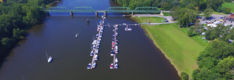
Chapter 1 — In the vicinity of paragraph 87
Delete the photograph of DESCHAILLONS-SUR-SAINT-LAURENT
(2007) and replace it with the new
DESCHAILLONS-SUR-SAINT-LAURENT (2020) photograph
provided in Section 4 of this Monthly Edition.
https://www.notmar.gc.ca/publications/monthly-mensuel/images/ed112020-part4-atl112-deschaillons-sur-saint-laurent.jpg
(Q2020-041.8)
Chapter 1 — In the vicinity of paragraph 98
Delete the photograph of RIVIÈRE BATISCAN (2007) and
replace it with the new RIVIÈRE BATISCAN (2020)
photograph provided in Section 4 of this Monthly
Edition.
https://www.notmar.gc.ca/publications/monthly-mensuel/images/ed112020-part4-atl112-riviere-batiscan.jpg
(Q2020-041.9)
SECTION 5 - LIST OF LIGHTS, BUOYS AND FOG SIGNALS CORRECTIONS
The amendments are highlighted and deletions are crossed out. For general and region-specific
information on the List of Lights, click on the following links:
Newfoundland and Labrador Coast,
Atlantic Coast,
Inland Waters and
Pacific Coast.
NEWFOUNDLAND AND LABRADOR COAST
| No. | Name |
Position ----- Latitude N. Longitude W. |
Light Characteristics |
Focal Height in m. above water |
Nominal Range |
Description ----- Height in meters above ground |
Remarks ----- Fog Signals |
|||
|---|---|---|---|---|---|---|---|---|---|---|
WEST COAST (LL 173 – 208.2) |
||||||||||
| 196.1 | Little Port light buoy XLH1 |
49 06
33.2 058 25 30.0 |
Fl | G | 4s | ….. | ….. | Green, marked “XLH1”. |
Year
round. Chart:4653 Edn 11/20 (N20-062) |
|
WHITE BAY (LL 235 – 269.3) |
||||||||||
| 238.3 | Smith’s Point light buoy KU3 |
Griquet Harbour
entrance. 51 31 23.6 055 27 19.0 |
Fl | G | 4s | ..... | ..... | Green spar, marked “KU3”. |
Seasonal. Chart:N/A Edn 11/20 (N20-059) |
|
NEWFOUNDLAND AND LABRADOR COAST (LL 269.99 – 325.23) |
||||||||||
| 287.4 | George Island Shoal light buoy HG |
W. of
island. 54 14 56.8 057 22 09.7 |
Q | W | 1s | ….. | ..... | Black and yellow, marked “HG”. |
Operates 24
h. Seasonal. Chart:5135 Edn 11/20 (N20-092) |
|
|
324.9 H0059.2 |
Stirrup Island Light |
E. of Okak Islands. 57 34 12.4 061 18 49.0 |
LFl | W | 10s | 74.8 | 6 |
Square skeleton tower, red and white rectangular
daymark 4.7 |
Seasonal. Chart:5055 Edn 11/20 (N20-095) |
|
NOTRE DAME BAY (LL 326 – 346.4, 354 – 395) |
||||||||||
| 360.54 | Black Island Shoal light buoy DHL2 |
49 34
29.1 054 43 10.4 |
Fl | R | 4s | ….. | ….. | Red spar, marked “DHL2”. |
Seasonal. Chart:4863 Edn 11/20 (N20-054) |
|
ATLANTIC COAST
| No. | Name |
Position ----- Latitude N. Longitude W. |
Light Characteristics |
Focal Height in m. above water |
Nominal Range |
Description ----- Height in meters above ground |
Remarks ----- Fog Signals |
|||
|---|---|---|---|---|---|---|---|---|---|---|
NOVA SCOTIA AND CAPE BRETON ISLAND (LL 686.5 – 704.1) |
||||||||||
|
690 H3422 |
Bear Head Direction |
Delete from list.
Chart:4302 Edn 11/20 (G20-231) |
||||||||
CAPE BRETON ISLAND, N.S. (LL 704.85 – 882.5) |
||||||||||
|
804.6 H0786 |
Kellys Cove Wharf |
S. corner of wharf. 46 17 19.3 060 26 13.5 |
LFl | W | 6s | 5.0 | 4 |
Pipe swing pole. 3.8 |
Flash 2 s; eclipse 4 s. Seasonal. Chart:4277 Edn 11/20 (G20-224) |
|
GULF OF ST. LAWRENCE (LL 883.2 – 940.3, 1169.1 – 1426, 1477.5 – 1584) |
||||||||||
| 1179.5 | North Miramichi Bar light buoy M18 |
47 08
56.6 065 01 10.5 |
Q | R | 1s | ….. | ….. | Red spar, marked “M18”. |
Seasonal (in
place year round). Chart:N/A Edn 11/20 (G20-097) |
|
| 1246.5 | Pokemouche Gully light buoy TH2 |
47 38 51.2 064 46 30.4 |
Fl | R | 4s | ….. | ….. | Red, marked “TH2”. |
Buoy may be repositioned due to shifting channel. Seasonal. Chart:4486 Edn 11/20 (G20-223) |
|
| 1246.75 |
Baie de
Pokemouche |
47 40
07.7 064 48 28.9 |
Q | R | 1s | ….. | ….. | Red, marked “TH46”. |
Buoy may be repositioned due to shifting channel. Seasonal. Chart:N/A Edn 11/20 (G20-233) |
|
| 1246.76 |
Baie de
Pokemouche |
47 39
41.6 064 47 10.3 |
Q | G | 1s | ….. | ….. | Green, marked “TH27”. |
Buoy may be repositioned due to shifting channel. Seasonal. Chart:N/A Edn 11/20 (G20-230) |
|
| 1262.11 | Fox Dens Gully light buoy TK4 |
47 53 10.3 064 29 53.8 |
Fl | R | 4s | ….. | ….. | Red spar, marked “TK4”. |
Seasonal. Chart:N/A Edn 11/20 (G20-257) |
|
| 1262.12 | Fox Dens Gully light buoy TK5 |
Inside gully entrance. 47 53 08.3 064 29 57.4 |
Fl | G | 4s | ….. | ….. | Green spar, marked “TK5”. |
Seasonal. Chart:N/A Edn 11/20 (G20-258) |
|
| 1262.15 | Fox Dens Gully light buoy TK9 |
47 53 07.1 064 30 13.4 |
Fl | G | 4s | ….. | ….. | Green spar, marked “TK9”. |
Operates 24 h. Seasonal. Chart:N/A Edn 11/20 (G20-255) |
|
| 1262.5 | Fox Dens Gully light buoy TK2 |
Off NE. tip of Île Lamèque. 47 53 12.8 064 29 31.0 |
Fl | R | 4s | ….. | ….. | Red spar, marked “TK2”. |
Buoy may be repositioned due to shifting channel. Seasonal. Chart:4913 Edn 11/20 (G20-250) |
|
| 1262.6 | Fox Dens Gully light buoy TK3 |
At gully entrance. 47 53 08.6 064 29 47.0 |
Fl | G | 4s | ….. | ….. | Green spar, marked “TK3”. |
Buoy may be repositioned due to shifting channel. Seasonal. Chart:N/A Edn 11/20 (G20-251) |
|
| 1262.75 | Fox Dens Gully light buoy TK15 |
47 53 04.4 064 30 27.5 |
Q | G | 1s | ….. | ….. |
Green |
Buoy may be repositioned due to shifting channel. Seasonal. Chart:N/A Edn 11/20 (G20-256) |
|
| 1264.1 | Fox Dens Gully light buoy EA30 |
W. of
gully. 47 52 50.3 064 31 34.4 |
Q | R | 1s | ..... | ..... | Red, marked “EA30”. |
Buoy may be repositioned due to shifting channel. Seasonal. Chart:N/A Edn 11/20 (G20-238) |
|
| 1330.7 | Bathurst Entrance light buoy EP28 |
Bathurst
Harbour entrance. 47 39 20.9 065 37 13.9 |
Fl | R | 4s | ….. | ….. | Red, marked “EP28”. |
Buoy may be repositioned due to shifting channel. Seasonal. Chart:4920 Edn 11/20 (G20-232) |
|
PRINCE EDWARD ISLAND (LL 942 – 1084.7) |
||||||||||
|
948.3 H0925 |
Fortune Bay North Sector |
Delete from
list. Chart:4403 Edn 11/20 (G20-227) |
||||||||
|
1027.31 H1060 |
Abrams Village Wharf Light |
46 26 25.9 064 06 48.4 |
Fl | G | 4s | ….. | 3 | Pipe swing pole, green-white-black square daymark. |
Seasonal. Chart:4905 Edn 11/20 (G20-225) |
|
NORTHUMBERLAND STRAIT (LL 1085 – 1165.9) |
||||||||||
|
1114 H1352 |
Cap-de-Cocagne Wharf |
On SW. corner of wharf extension. 46 21 15.5 064 34 33.0 |
Fl | G | 4s | ….. | 4 |
Pipe swing pole, green-white-black square
daymark. 4.0 |
Flash 1 s; eclipse 3 s. Seasonal. Chart:4909 Edn 11/20 (G20-248) |
|
|
1129 H1378 |
Richibucto Cape Breakwater |
46 40 23.9 064 42 38.1 |
Fl | R | 4s | 4.3 | 5 |
Cylindrical mast. 2.8 |
Flash 1 s; eclipse 3 s. Seasonal. Chart:4909 Edn 11/20 (G20-249) |
|
ST. LAWRENCE RIVER (LL 1584.5 – 1772, 1823.8 – 2185.7, 2273 – 2365.95) |
||||||||||
|
1652 H1830 1653 H1830.1 |
Mont-Louis range |
| | | | | | |
Delete from
list. Delete from list. Chart:1230 Edn 11/20 (Q20-127, 128) |
|||||||
| 1652.5 | Mont-Louis |
49 13
44.9 065 43 56.7 |
Iso |
R W G |
4s | 6.7 | 11 |
Skeleton tower, red
and white rectangular daymark. 3.2 |
Visible over an arc
of 015°; red from 183.5° to 178°; white from 178° to 174°; green from 174° to 168.5°. Operates 24 h. Seasonal (in place year round). Chart:1230 Edn 11/20 (Q2020-169) |
|
| 1895 | Cap Gribane light buoy K95 |
Chenal du
Nord. 47 08 04.8 070 40 46.1 |
Fl | G | 4s | ..... | ..... | Green spar, marked “K95”. |
Year
round. Chart:1317 Edn 11/20 (Q20-174) |
|
| 1969 | Haut-fond Saint-Augustin light buoy Q22 |
Route
Saint-Augustin. 46 42 30.0 071 28 48.6 |
Fl | R | 4s | ..... | ..... | Red spar, marked “Q22”. |
Year round. Chart:1315 Edn 11/20 (Q20-171) |
|
| 1973 | Pointe aux Trembles light buoy Q32 |
Traverse
Saint-Antoine. 46 41 11.6 071 33 10.0 |
Fl | R | 4s | ..... | ..... | Red spar, marked “Q32”. |
Year round. Chart:1315 Edn 11/20 (Q20-175) |
|
| 1974.5 | Pointe aux Trembles light buoy Q34 |
Traverse
Saint-Antoine. 46 40 42.6 071 34 32.4 |
Fl | R | 4s | ..... | ..... | Red spar, marked “Q34”. |
Year round. Chart:1315 Edn 11/20 (Q20-176) |
|
| 1979 | Pointe du Chalet des Phares light buoy Q38 |
Ruisseau
Méthot. 46 40 03.9 071 36 51.1 |
Fl | R | 4s | ..... | ..... | Red spar, marked “Q38”. |
Year round. Chart:1315 Edn 11/20 (Q20-177) |
|
| 2047 | Battures Saint-Pierre light buoy D71 |
Route de
Gentilly. 46 30 00.3 072 13 44.0 |
Fl | G | 4s | ..... | ..... | Green spar, marked “D71”. |
Year round. Chart:1313 Edn 11/20 (Q20-216) |
|
| 2104.6 | Pont Laviolette light buoy C65 |
Downstream of
the bridge. 46 18 48.7 072 33 08.3 |
Q | G | 1s | ..... | ..... | Green spar, marked “C65”. |
Year round. Chart:1313 Edn 11/20 (Q20-170) |
|
| 2122 | Banc des Anglais light buoy S13 |
Traverse de
Nicolet. 46 15 43.5 072 40 34.4 |
Q | G | 1s | ..... | ..... | Green spar, marked “S13”. |
Year round. Chart:1312 Edn 11/20 (Q20-178) |
|
| 2123 | Banc des Anglais light buoy S17 |
Courbe de la
Pointe du Lac. 46 15 44.9 072 41 10.0 |
Q | G | 1s | ..... | ..... | Green spar, marked “S17”. |
Year round. Chart:1312 Edn 11/20 (Q20-180) |
|
| 2128 | Pointe-du-Lac light buoy S25 |
Route de la
Pointe du Lac. 46 15 35.5 072 42 27.2 |
Q | G | 1s | ..... | ..... | Green spar, marked “S25”. |
Year round. Chart:1312 Edn 11/20 (Q20-181) |
|
| 2129.3 | Pointe-du-Lac light buoy S27 |
Route de la
Pointe du Lac. 46 15 25.0 072 42 59.9 |
Q | G | 1s | ..... | ..... | Green spar, marked “S27”. |
Year round. Chart:1312 Edn 11/20 (Q20-182) |
|
| 2139.5 | Louiseville light buoy S77 |
Route
Louiseville Aval. 46 11 35.8 072 53 01.8 |
Q | G | 1s | ..... | ..... | Green spar, marked “S77”. |
Year round. Chart:1312 Edn 11/20 (Q20-183) |
|
| 2142 | Louiseville light buoy S81 |
Courbe
Louiseville. 46 11 13.2 072 54 01.7 |
Fl | G | 4s | ..... | ..... | Green spar, marked “S81”. |
Year round. Chart:1312 Edn 11/20 (Q20-184) |
|
| 2151 | Battures Saint-François light buoy S97 |
Courbe
Maskinongé. 46 10 00.7 072 55 56.4 |
Q | G | 1s | ..... | ..... | Green spar, marked “S97”. |
Year round. Chart:1312 Edn 11/20 (Q20-185) |
|
| 2163 | Le Banc de Sable light buoy S110 |
Route Île aux
Raisins. 46 07 36.7 072 57 31.1 |
Q | R | 1s | ..... | ..... | Red spar, marked “S110”. |
Year round. Chart:1312 Edn 11/20 (Q20-186) |
|
| 2174 | Île à la Pierre light buoy S126 |
Route
Sainte-Anne-de-Sorel. 46 04 54.7 073 01 00.2 |
Fl | R | 4s | ..... | ..... | Red spar, marked “S126”. |
Year round. Chart:1312 Edn 11/20 (Q20-212) |
|
| 2174.8 | Île de Grâce light buoy S130 |
Route
Sainte-Anne-de-Sorel. 46 04 14.4 073 02 13.8 |
Fl | R | 4s | ..... | ..... | Red spar, marked “S130”. |
Year
round. Chart:1312 Edn 11/20 (Q20-213) |
|
| 2179 | Île de Grâce light buoy S136 |
Battures de
l’Île de Grâce. 46 03 59.8 073 02 52.3 |
Q | R | 1s | ..... | ..... | Red spar, marked “S136”. |
Year round. Chart:1312 Edn 11/20 (Q20-187) |
|
| 2181.15 | Île de Grâce light buoy S140 |
Route de l’Île
du Moine. 46 03 50.9 073 03 34.3 |
Fl | R | 4s | ..... | ..... | Red spar, marked “S140”. |
Year
round. Chart:1312 Edn 11/20 (Q20-214) |
|
| 2182 | Haut-fond Nepigon light buoy S146 |
Courbe
Nepigon. 46 03 39.7 073 05 36.6 |
Fl | R | 4s | ..... | ..... | Red spar, marked “S146”. |
Year round. Chart:1312 Edn 11/20 (Q20-215) |
|
| 2273 | Tracy light buoy M1 |
46 02 08.7 073 09 50.4 |
Q | G | 1s | ..... | ..... | Green spar, marked “M1”. |
Year round. Chart:1311 Edn 11/20 (Q20-188) |
|
| 2273.5 | Tracy light buoy M2 |
Route de l’Île
Dupas. 46 01 17.0 073 10 20.5 |
Fl | R | 4s | ..... | ..... | Red spar, marked “M2”. |
Year round. Chart:1311 Edn 11/20 (Q20-189) |
|
| 2280 | Île Saint-Ours bifurcation light buoy ISO |
Route de l’Île
Saint-Ours. 45 56 45.5 073 12 50.7 |
Fl (2+1) | R | 6s | ..... | ..... | Red-green-red spar, marked “ISO”. |
Year round. Chart:1311 Edn 11/20 (Q20-190) |
|
| 2281.5 |
|
Courbe de
Bellmouth. 45 54 40.7 073 12 46.6 |
Fl | G | 4s | ..... | ..... | Green spar, marked “M17”. |
Year
round. Chart:1311 Edn 11/20 (Q20-191) |
|
| 2285 | Île Saint-Ours light buoy M20 |
Courbe de
Bellmouth. 45 54 29.5 073 13 05.0 |
Q | R | 1s | ..... | ..... | Red spar, marked “M20”. |
Year round. Chart:1311 Edn 11/20 (Q20-194) |
|
| 2294.6 | Contrecoeur light buoy M38 |
Route de
Contrecoeur. 45 52 35.9 073 15 12.5 |
Fl | R | 4s | ..... | ..... | Red spar, marked “M38”. |
Year round. Chart:1311 Edn 11/20 (Q20-192) |
|
| 2295.2 | Contrecoeur light buoy M46 |
Route de
Contrecoeur. 45 51 38.6 073 16 06.0 |
Fl | R | 4s | ..... | ..... | Red spar, marked “M46”. |
Year
round. Chart:1311 Edn 11/20 (Q20-193) |
|
| 2314 | Contrecoeur light buoy M52 |
Traverse de
Contrecoeur. 45 50 53.3 073 16 32.7 |
Q | R | 1s | ..... | ..... | Red spar, marked “M52”. |
Year round. Chart:1311 Edn 11/20 (Q20-195) |
|
| 2320.5 | Contrecoeur light buoy M54 |
Chenal de
Verchères – Contrecoeur. 45 50 33.9 073 16 52.8 |
Fl | R | 4s | ..... | ..... | Red spar, marked “M54”. |
Year
round. Chart:1311 Edn 11/20 (Q20-196) |
|
| 2321 | Contrecoeur light buoy M57 |
Chenal de
Verchères – Contrecoeur. 45 50 29.3 073 16 43.4 |
Fl | G | 4s | ..... | ..... | Green spar, marked “M57”. |
Year
round. Chart:1311 Edn 11/20 (Q20-197) |
|
| 2327.4 |
|
Traverse de
Verchères. 45 46 40.0 073 21 49.0 |
Q | G | 1s | ..... | ..... | Green spar, marked “M87”. |
Year round. Chart:1311 Edn 11/20 (Q20-198) |
|
| 2332 | Cap Saint-Michel light buoy M117 |
Chenal du
Cap-Saint-Michel, Verchères. 45 43 13.8 073 25 43.9 |
Fl | G | 4s | ..... | ..... | Green spar, marked “M117”. |
Year round. Chart:1310 Edn 11/20 (Q20-199) |
|
|
2335 H2484 2335.1 2336 H2484.1 |
Île Sainte-Thérèse Lower range |
| | | | | | | | | | |
E. side of island. 45 41 06.8 073 27 32.7 212°53' 152.7 m from front. |
F F F |
G G G |
..... ….. ..... |
11.9 11.9 18.1 |
8 4 14 |
Skeleton tower, fluorescent red slatwork daymark, black
vertical stripe. 6.2 Skeleton tower, fluorescent red slatwork daymark, black vertical stripe. 13.1 |
Visible 360°. Increased intensity in line of range. Year round. Visible in line of range. Year round. Chart:1310 Edn 11/20 (Q20-162) |
| 2365 | Pont-tunnel Louis-Hippolyte-La Fontaine light buoy M171 |
Traverse
de Longue-Pointe. 45 35 09.3 073 29 57.8 |
Q | G | 1s | ..... | ..... | Green spar, marked “M171”. |
Year round. Chart:1310 Edn 11/20 (Q20-210) |
|
ST. LAWRENCE RIVER SEAWAY (LL 2369 – 2384) |
||||||||||
| 2377 | Longueuil light buoy M189 |
Longueuil
shoal. 45 32 16.2 073 31 36.5 |
Fl | G | 4s | ..... | ..... | Green spar, marked “M189”. |
Year
round. Chart:1310 Edn 11/20 (Q20-211) |
|
INLAND WATERS
| No. | Name |
Position ----- Latitude N. Longitude W. |
Light Characteristics |
Focal Height in m. above water |
Nominal Range |
Description ----- Height in meters above ground |
Remarks ----- Fog Signals |
|||
|---|---|---|---|---|---|---|---|---|---|---|
TRENT-SEVERN WATERWAY (LL 1346.2 – 1375.1) |
||||||||||
| 1365 | Maskinonge River (Jersey) |
Delete from
list. Chart:2028 Edn 11/20 (D20-026) |
||||||||
| 1365.5 | Maskinonge (Jersey) River light buoy SA1 |
Off entrance
pier. 44 13 32.9 079 28 20.8 |
Fl | G | 4s | ….. | ….. | Green spar, marked “SA1”. |
Seasonal. Chart:2028 Edn 11/20 (D20-027) |
|
RAINY LAKE (LL 1445 – 1468) |
||||||||||
| 1446 | Crowe Island |
Delete from
list. Chart:6108 Edn 11/20 (D20-028) |
||||||||
| 1446.25 | Crowe Island light buoy A18 |
W. of
island. 48 43 58.7 093 18 19.4 |
Fl | R | 4s | ….. | ….. | Red spar, marked “A18”. |
Seasonal (in
place year round). Chart:6108 Edn 11/20 (D20-030) |
|
| 1446.5 | Pot Island light buoy A15/1 |
Off
island. 48 42 54.4 093 18 43.7 |
Fl | G | 4s | ….. | ….. | Green spar, marked “A15/1”. |
Seasonal (in
place year round). Chart:6108 Edn 11/20 (D20-031) |
|
CANADIAN COAST GUARD - MARINE INFORMATION REPORT AND SUGGESTION SHEET
Name of Ship or Sender:..................................................................... Date:....................................
Address of Sender:..........................................................................................................................
Street # Street Name
Town / City:.............................. Prov / State:....................... Postal Code / Zip Code: ........................
Tel / Fax / E-mail address of sender (if appropriate):............................................................................
Observation Date:............................................. Time (UTC): ...........................................................
Geographical Position:......................................................................................................................
Coordinate Position: Lat: ............................................... Long:.........................................................
Position Method: DGPS GPS with WAAS GPS Radar Other
Horizontal Datum Used: WGS 84 NAD 27 Other
Estimated Position Accuracy:............................................................................................................
Chart #:............................................................ Datum: NAD 27 NAD 83
Chart Edition:.................................................... Last Correction applied:............................................
Publications affected: (Quote edition and page number):.....................................................................
*Full details (Attach additional sheets as necessary):...........................................................................
Mariners are requested to notify the responsible authorities when new or suspected dangers to navigation are discovered, changes are observed in aids to navigation, or corrections to publications are seen to be necessary.
In the case of new or suspected dangers to navigation, it is important that all details be given in order to aid with future investigations. Items of interest include heights, depths, physical description, type of bottom and equipment method used to position the item. It is helpful to mark details on the chart, which will be promptly replaced by the Canadian Hydrographic Service.
Reports should be made to the nearest Marine Communications and Traffic Services Centre (MCTS) and should be confirmed in writing to:
Leader, Notices to Mariners
Canadian Coast Guard
Department of Fisheries and Oceans
Montréal, QC H2Y 2E7
In the case of information concerning aids to navigation or the List of Lights, Buoys and Fog Signals book.
OR
Director General, Canadian Hydrographic Service & Oceanographic Services
Department of Fisheries and Oceans
Ottawa, ON K1A 0E6
In the case of new or suspected dangers to navigation or where corrections to "Sailing Directions" appear to be necessary.
For general questions on Canadian Coast Guard programs or services, please send an e-mail to:
info@dfo-mpo.gc.ca (Please include your postal code and e-mail address).
You can access the online form on the following page: https://www.notmar.gc.ca/incident-en.php or you can use the printable pdf version : https://www.notmar.gc.ca/publications/monthly-mensuel/images/monthly-form-en.pdf