
Archived information
The Standard on Web Usability replaces this content. This content is archived because Common Look and Feel 2.0 Standards have been rescinded.
Archived information is provided for reference, research or recordkeeping purposes. It is not subject to the Government of Canada Web Standards and has not been altered or updated since it was archived.
NOTICES TO MARINERS
PUBLICATION
EASTERN EDITION

Safety First, Service Always
Published Monthly by the
CANADIAN COAST GUARD
www.notmar.gc.ca/subscribe/
CONTENTS
| Section 1 | General and Safety Information |
| Section 2 | Chart Corrections |
| Section 3 | Radio Aids to Marine Navigation Corrections |
| Section 4 | Sailing Directions and Small Craft Guide Corrections |
| Section 5 | List of Lights, Buoys and Fog Signals Corrections |
Canadian Coast Guard Programs
Aids to Navigation and Waterways
Fisheries and Oceans Canada
Montreal, Quebec
H2Y 2E7
© Her Majesty the Queen in Right of Canada, 2018
DFO/2018-2002
Fs152-6E-PDF
ISSN 1719-7708
Disponible en français :
Publication des Avis aux navigateurs
Édition de l'Est
Édition mensuelle Nº03/2018
Fisheries and Oceans Canada
Official Publication of the Canadian Coast Guard
DFO/2018-2002
EXPLANATORY NOTES
Geographical positions refer directly to the graduations of the largest scale Canadian Hydrographic chart unless otherwise indicated.
Bearings refer to the true compass and are measured clockwise from 000° (North) clockwise to 359°; those relating to lights are from seaward.
Visibility of lights is that in clear weather.
Depths - The units used for soundings (metres, fathoms or feet) are stated in the title of each chart.
Elevations are normally given above Higher High Water, Large Tide unless otherwise indicated.
Distances may be calculated as follows:
1 nautical mile = 1,852 metres (6,076.1 feet)
1 statute mile = 1,609.3 metres (5,280 feet)
1 metre = 3.28 feet
Temporary & Preliminary Notices are indicated by a (T) or a (P) in Section 1, respectively. Please note that Nautical charts are not amended by the Canadian Hydrographic Service for Temporary (T) and Preliminary (P) Notices. It is recommended that mariners chart these corrections in pencil. The list of charts affected by Temporary and Preliminary Notices are revised and promulgated quarterly in Section 1 of the Monthly Edition.
Please note that, in addition to the temporary and preliminary changes normally advertised as (T) and (P) Notices, there are a few permanent changes to aids to navigation that have been advertised as Preliminary Notices to Mariners while charts are being updated for new editions.
Marine Information Report & Suggestion Sheet
Mariners are requested to notify the responsible authorities when new or suspected dangers to navigation are discovered, changes observed in aids to navigation or corrections to publications are seen
to be necessary. Such communications can be made using the Marine Information Report & Suggestion Sheet inserted on the last
page of each monthly edition of Notices to Mariners.
Canadian Hydrographic Service - Information Published in Section 2 of Notices to Mariners
Mariners are advised that only the most critical changes that directly affect safety to navigation are issued in Section 2 – Chart Corrections. This limitation
is required to ensure that charts remain as clear and easy to read as possible. As a result, mariners may see minor discrepancies of a
non-critical nature between information in official publications. For example, a small change in the nominal range or focal height of a light
may not result in the production of a chart correction in Notices to Mariners, but may result in a correction in the List of Lights, Buoys and
Fog Signals publication.
In case of discrepancy between information provided on CHS charts relating to aids to navigation, and the List of Lights, Buoys and Fog Signals publication, the latter shall be deemed as containing the most up-to-date information.
Canadian Nautical Charts & Publications
A source list of Canadian nautical charts and publications is published in Notice No. 14 of the Notices to Mariners Annual Edition 2018. The source supply and the prices
effective at the time of printing are listed. For current chart edition dates, please refer to the following website:
www.chs-shc.gc.ca/charts-cartes/paper-papier/index-eng.asp
CHART CORRECTIONS - SECTION 2
Corrections to nautical charts will be listed in numerical order by chart number. Each chart correction listed applies only to that particular chart. Related charts, if any, will have their own specific correction listed separately.
Users should also refer to CHS Chart 1: Symbols, Abbreviations and Terms for additional information pertaining to the correction of charts.
The illustration below describes the elements that will comprise a typical Section 2 chart correction:

The last correction number is identified with the LNM/D or Last Notice to Mariners Number / Date.
NOTICES TO MARINERS WEBSITE – MONTHLY EDITIONS, CHART CORRECTIONS, AND CHART PATCHES
The Notices to Mariners website allows users to access the monthly publications,
chart corrections, and chart patches.
Users can subscribe for free to the email notification service
to receive notifications when charts of interest are updated, including their patches, as well as when a new monthly edition becomes available online.
ADVISORY NOTICES TO SHIPPING (BROADCAST AND WRITTEN)
The Canadian Coast Guard is implementing a number of changes to the aids to navigation system in Canada.
These changes are advertised as Notices to Shipping (Broadcast and Written) by the Canadian Coast Guard, and are then followed up with Notices to Mariners, then charts are updated by hand correction, reprints or new editions.
Mariners are advised that all relevant Written Notices to Shipping should be kept until superseded by Notices to Mariners or through revised charts issued by the Canadian Hydrographic Service (CHS).
Written Notices to Shipping are available on the Canadian Coast Guard website at: www.ccg-gcc.gc.ca/eng/CCG/NOTSHIP.
The Canadian Hydrographic Service is reviewing the impact of these changes with the Canadian Coast Guard and together are preparing an action plan on the issuing of chart revisions.
For further information, contact your local Regional Notices to Shipping (NOTSHIP) issuing authorities.
Newfoundland
* Port aux Basques MCTS Centre
Canadian Coast Guard
49 Stadium Rd.
P.O. Box 99
Port aux Basques, NL A0M 1C0
Telephone: (709) 695-2168 or 1-800-563-9089
Facsimile: (709) 695-7784
Email: notshippax@dfo-mpo.gc.ca
Website: http://www.ccg-gcc.gc.ca/eng/CCG/Notship#nfld
Central & Arctic
* Prescott MCTS Centre
Canadian Coast Guard
401 King Street West
P.O. Box 1000
Prescott, ON K0E 1T0
“C” Series NOTSHIPs
Telephone: (613) 925-0666
Facsimile: (613) 925-4519
Email: CA.XCA-NotshipDesk@dfo-mpo.gc.ca
Website: http://www.ccg-gcc.gc.ca/eng/CCG/Notship-Home
Maritimes
* Sydney MCTS Centre
Canadian Coast Guard
1190 Westmount Road
Sydney, NS B1R 2J6
Telephone: (902) 564-7751 or 1-800-686-8676
Facsimile: (902) 564-7662
Email: notshipssyd@mar.dfo-mpo.gc.ca
Website: http://www.ccg-gcc.gc.ca/eng/CCG/Notship#maritime
Québec
* Les Escoumins MCTS Centre
Canadian Coast Guard
35, rue Otis
Les Escoumins, QC G0T 1K0
Telephone: (418) 233-2308
Facsimile: (418) 233-3299
Email: opsavis@dfo-mpo.gc.ca
Website: www.marinfo.gc.ca/en/avisecrits/index.asp
* Iqaluit MCTS Centre
Operational from approximately mid-May until late December.
Canadian Coast Guard
P.O. Box 189
Iqaluit, NU X0A 0H0
“A” Series NOTSHIPs
Telephone: (867) 979-5269
Facsimile: (867) 979-4264
Email: IqaNordreg@innav.gc.ca
Website: http://www.ccg-gcc.gc.ca/eng/CCG/Notship-Home
“H” Series NOTSHIPs
Telephone: (867) 979-0310
Facsimile: (867) 979-4264
Email: Iqamck01@innav.gc.ca
Website: http://www.ccg-gcc.gc.ca/eng/CCG/Notship-Home
* Service available in English and French.
Index
NUMERICAL INDEX OF CANADIAN CHARTS AFFECTED
| 1233 | 2309 | 4437 | 4970 |
| 1236 | 2310 | 4460 | 4971 |
| 1310 | 2315 | 4466 | 4980 |
| 1311 | 4002 | 4470 | 5179 |
| 1312 | 4013 | 4471 | 5300 |
| 1313 | 4023 | 4472 | 5450 |
| 1314 | 4024 | 4483 | 5467 |
| 1315 | 4116 | 4486 | 6270 |
| 1316 | 4203 | 4584 | 6272 |
| 1317 | 4266 | 4642 | 6425 |
| 1360 | 4386 | 4885 | 7083 |
| 2054 | 4404 | 4920 | 7783 |
| 2300 | 4405 | 4921 | |
| 2308 | 4426 | 4956 |
SECTION 1 - GENERAL AND SAFETY INFORMATION
CANADIAN HYDROGRAPHIC SERVICE – ANNOUNCEMENT REGARDING CHS CHART PATCHES
Colour Web Patches are free to the mariner, and given the quality of many printers, should reproduce well. They will be available in real time all around the world.
CHS welcomes your feedback on this service at chsinfo@dfo-mpo.gc.ca
CANADIAN HYDROGRAPHIC SERVICE – CUMULATIVE CHART CORRECTIONS
The cumulative chart corrections published in
Notices to Mariners can now be accessed
at
https://www.notmar.gc.ca/corrections-en.php
CANADIAN HYDROGRAPHIC SERVICE – CURRENT CHART EDITION DATES
CHART
EDITIONS
The three terms
described below are used to indicate the publication status
of Canadian charts.
NEW CHART -
"NEWCHT"
The first
publication of a Canadian chart embracing an area not
previously charted to the scale shown, or embracing an area
different from any existing Canadian chart.
NEW EDITION -
"NEWEDT"
A new issue of
an existing chart containing amendments essential to
navigation in addition to those issued in Notices
to Mariners and making existing editions
obsolete.
REPRINTS
A new
issue of the current edition of a chart incorporating no
amendments of navigational significance other than those
previously promulgated in Notices to
Mariners. It may also contain amendments from
other sources provided they are not essential to navigation.
Previous printings of the current edition remain in
force.
The current chart edition dates can be accessed at www.chs-shc.gc.ca/charts-cartes/paper-papier/index-eng.asp
CANADIAN HYDROGRAPHIC SERVICE – PRINT ON DEMAND CHARTS - CARE AND USE
Background
By providing nautical charts to the public, the goal of the Canadian Hydrographic Service (CHS) is to provide services for safe navigation in a fiscally responsible manner. As a result, CHS continues to expand its portfolio of nautical paper charts that are printed using Print On Demand (POD) technology. These charts are easily recognized by their whiter paper and the coloured logo of the Canadian Hydrographic Service. This new technology enables CHS to print charts in a more efficient manner, while enhancing chart content through being able to quickly add new and important information. POD technology provides customers with up-to-date charts without the historical hand-drawn corrections or glued-on patches. Additionally, this technology eliminates out-of-stock situations which arise with the traditional printing and warehousing methods. In the event of a national emergency, CHS can respond to the appropriate authorities with the best available information very quickly.
Care of Your POD Chart
CHS encourages its customers to handle the POD charts more carefully than the traditional lithographic charts. When plotting information on POD charts, use HB pencils and apply limited pressure. Testing has suggested that an Indian gum eraser is more effective than alternatives when used on the product. This eraser is also suitable for charts printed using lithographic processes.
CANADIAN HYDROGRAPHIC SERVICE, TRANSPORT CANADA – NAVIGATION SAFETY - ECDIS
Mariners are advised that ECDIS may not display some isolated shoal depths when operating in "base or standard display" mode. Route planning and monitoring alarms for these shoal depths may not always be activated. To ensure safe navigation and to confirm that a planned route is clear of such dangers, mariners should visually inspect the planned route and any deviations from it using ECDIS configured to display "all data". The automated voyage planning check function should not be solely relied upon.
TRANSPORT CANADA – RESTRICTED SPEED AREA - ST. CLAIR AND DETROIT RIVERS
Since November 14, 2012, the restricted speed area currently in place as per the St. Clair and Detroit River Navigation Safety Regulations between the Detroit River light and Peche Island light is reduced in size by relocatingthe southern point of the restricted speed area from its current location at the Detroit River light to a new location at Bar Point light D33. (This notice refers to the previous one published in November 2012 with number *1103.)
CANADIAN HYDROGRAPHIC SERVICE – MODIFICATION TO CATALOGUE 2: PACIFIC COAST/CÔTE PACIFIQUE
The Canadian Hydrographic Service has been recently
informed that there is an error in the following chart
catalogue:
Catalogue 2:
Pacific Coast/Côte pacifique
Affix patch to Catalogue 2: Pacific Coast/Côte
pacifique provided in Section 1 of this monthly
edition.
https://www.notmar.gc.ca/publications/monthly-mensuel/images/ed072017-part1-catalogue2-patch.pdf
CANADIAN HYDROGRAPHIC SERVICE – CORRECTION TO CHART NO. 1 PUBLICATION DATE
The Canadian Hydrographic Service would like to inform you that there is an error in the edition date of some versions of Chart No. 1, 2016. The correct edition date is March 2016. For all other updates to Chart No. 1, please refer to the following web pages:
English -
http://www.charts.gc.ca/publications/chart1-carte1/updates-eng.asp
French -
http://www.charts.gc.ca/publications/chart1-carte1/updates-fra.asp
CANADIAN HYDROGRAPHIC SERVICE – MODIFICATIONS TO THE 2018 CANADIAN TIDE AND CURRENT TABLES VOLUME 3 – ST. LAWRENCE RIVER AND SAGUENAY FJORD
The Canadian Hydrographic Service of the Quebec Region identified information missing in the 2018 Canadian Tide and Current Tables Volume 3 - St. Lawrence River and Saguenay Fjord, page 67.
Replace the part of Table 3 with the patch provided
in Section 1 of this monthly
edition.
https://www.notmar.gc.ca/publications/monthly-mensuel/images/ed012018-part1-tidal-information-vol3-p67-patch.pdf
CANADIAN HYDROGRAPHIC SERVICE – NEW LOCATION TO DOWNLOAD PATCHES
The Canadian Hydrographic Service has moved patch downloads from http://www.chs-shc.gc.ca/patches/ to ftp://ftp.dfo-mpo.gc.ca/patches/. The PDF versions of the monthly editions of Notices to Mariners prior to July 2017 are published with the previous location to download patches, while the HTML versions have the updated hyperlinks to the new location. These changes have also been applied to the “Search Chart Corrections” service on the Notices to Mariners website (https://www.notmar.gc.ca/corrections-en.php).
*301 CANADIAN HYDROGRAPHIC SERVICE – NAUTICAL CHARTS
|
CHARTS |
MAIN TITLE |
SCALE |
PUBLISHED |
CAT# |
PRICE |
|---|---|---|---|---|---|
|
New Charts |
|||||
|
4970 |
Baie de Bonne-Espérance à/to Île Mistanoque |
1:40 000 |
04-AUG-2017 |
1 |
20.00 |
|
4971 |
Blanc Sablon à/to Baie de Bonne-Espérance |
1:40 000 |
10-NOV-2017 |
1 |
20.00 |
|
New Editions |
|||||
|
1313 |
Batiscan au/to Lac Saint-Pierre |
1:40 000 |
03-NOV-2017 |
1 |
20.00 |
|
1314 |
Donnacona à/to Batiscan |
1:40 000 |
06-OCT-2017 |
1 |
20.00 |
|
Charts Permanently Withdrawn |
|||||
|
4470 |
Blanc Sablon à/to Middle Bay |
||||
|
4471 |
Baie au Saumon à/to Baie des Homards |
||||
|
4980 |
Blanc Sablon |
||||
*302 CANADIAN HYDROGRAPHIC SERVICE – ELECTRONIC NAVIGATIONAL CHARTS
|
S-57 ENC NUMBER |
CHART TITLE |
|---|---|
|
NEW PRODUCTS |
|
|
CA573471 |
Daniel Island Harbour |
*303 CANADIAN HYDROGRAPHIC SERVICE – RASTER DIGITAL CHARTS (BSB V3)
|
CHARTS |
MAIN TITLE |
SCALE |
PUBLISHED |
|---|---|---|---|
|
New Charts |
|||
|
RM-4970 |
Baie de Bonne-Espérance à/to Île Mistanoque |
1:40 000 |
04-AUG-2017 |
|
RM-4971 |
Blanc Sablon à/to Baie de Bonne-Espérance |
1:40 000 |
10-NOV-2017 |
|
New Editions |
|||
|
RM-1313 |
Batiscan au/to Lac Saint-Pierre |
1:40 000 |
03-NOV-2017 |
|
RM-1314 |
Donnacona à/to Batiscan |
1:40 000 |
06-OCT-2017 |
|
RM-3727 |
Cape Calvert to/à Goose Island including / y compris Fitz Hugh Sound |
1:73 584 |
23-SEP-2016 |
|
RM-4277 |
Great Bras D'Or, St. Andrews Channel and/et St. Anns Bay |
1:40 000 |
29-DEC-2017 |
|
RM-5505 |
Bélanger Island à/to Cotter Island |
1:250 000 |
04-AUG-2017 |
|
Charts Permanently Withdrawn |
|||
|
RM-4980 |
Blanc Sablon |
||
*304 TRANSPORT CANADA – SHIP SAFETY BULLETIN #01/2018
This is to notify you that a new Ship Safety Bulletin has recently been posted to the Transport Canada website at www.tc.gc.ca/ssb-bsn/.
To go online to view or download this bulletin, please click on the link below:
SSB#01/2018 – How to Meet STCW Requirements for Masters, Deck Officers and Other Crew Members of Certain Canadian Ships Operating in Polar Waters
RDIMS#13405647
Sign yourself up for e-Bulletin to receive an e-mail notice each time a new Ship Safety Bulletin is published on our Website.
Contact us at: marinesafety-securitemaritime@tc.gc.ca or 1-855-859-3123 (Toll Free).
*305 TRANSPORT CANADA – SHIP SAFETY BULLETIN #02/2018
This is to notify you that a new Ship Safety Bulletin has recently been posted to the Transport Canada website at www.tc.gc.ca/ssb-bsn/.
To go online to view or download this bulletin, please click on the link below:
SSB#02/2018
– Guidelines for Over-Wintering of vessels carrying
oil or NLS in waters under Canadian Jurisdiction - TP
15295
RDIMS#13429378
Sign yourself up for e-Bulletin to receive an e-mail notice each time a new Ship Safety Bulletin is published on our Website.
Contact us at: marinesafety-securitemaritime@tc.gc.ca or 1-855-859-3123 (Toll Free).
*306 TRANSPORT CANADA – SHIP SAFETY BULLETIN #03/2018
This is to notify you that a new Ship Safety Bulletin has recently been posted to the Transport Canada website at www.tc.gc.ca/ssb-bsn/.
To go online to view or download this bulletin, please click on the link below:
SSB#03/2018
– Standards for the Construction, Inspection, and
Operation of Barges Carrying Oil or Dangerous Chemicals in
Bulk
RDIMS#13383471
Sign yourself up for e-Bulletin to receive an e-mail notice each time a new Ship Safety Bulletin is published on our Website.
Contact us at: marinesafety-securitemaritime@tc.gc.ca or 1-855-859-3123 (Toll Free).
*307 CANADIAN COAST GUARD PUBLICATION – AMENDMENTS TO NOTICES TO MARINERS 1 TO 46 ANNUAL EDITION 2018 - SECTION A2, NOTICE 5B: GENERAL GUIDELINES FOR NATIONAL PARKS
|
Page # |
AMEND |
TO READ |
|---|---|---|
|
Page 13 |
2. National Parks in Central Canada |
3. National Parks in Central Canada |
|
Page 14 |
*309(P) SYDNEY HARBOUR – NOTICE OF PROPOSED CHANGES
Reference Chart: 4266
The Canadian Coast Guard proposes to permanently change the following aids to navigation:
|
LL # |
Aid Name |
Position |
Proposed Suggestions |
|---|---|---|---|
|
782 |
Sydney Range |
46°
10’
48.2”N |
Change lantern colour from yellow to green, and increase the intensity of the lantern. |
|
783 |
Sydney Range |
213°36’ 756.1 m from front. |
Change lantern colour from yellow to green, and increase the intensity of the lantern. |
Comments on this action are solicited from mariners and other interested parties by June 30th, 2018, three months following the initial publication date of March 30th, 2018. Comments should be directed to the following:
Superintendent, Renee
Pope
Aids to Navigation and
Waterways
Canadian Coast Guard
P.O. Box 5667
St. John’s, NL A1C 5X1
Telephone: (709)
772-2800
Email:
renee.pope@dfo-mpo.gc.ca
Any objections raised must state the facts on which they are based and should include supporting information on safety, commerce and public benefit.
(G2018-039)
*310(P) RIVIÈRE RISTIGOUCHE / RESTIGOUCHE RIVER – NOTICE OF PROPOSED CHANGES
Reference Chart: 4426
The Canadian Coast Guard proposes to permanently change the following aid to navigation:
|
LL # |
Aid Name |
Position |
Proposed Changes |
|---|---|---|---|
|
1344 |
Dalhousie (Douglas) Island |
48° 04’
20.2”N |
Change lantern to green all around port hand light; intensity of lantern decreased to 5nm; Fl 2 s Ec 2 s; add 1.08 nm port hand daybeacon. |
Comments on this action are solicited from mariners and other interested parties by June 30th, 2018, three months following the initial publication date of March 30th, 2018. Comments should be directed to the following:
Superintendent, Renee
Pope
Aids to Navigation and
Waterways
Canadian Coast Guard
P.O. Box 5667
St. John’s, NL A1C 5X1
Telephone: (709)
772-2800
Email:
renee.pope@dfo-mpo.gc.ca
Any objections raised must state the facts on which they are based and should include supporting information on safety, commerce and public benefit.
(G2018-013)
*311(P) CHARLOTTETOWN HARBOUR – NOTICE OF PROPOSED CHANGES
Reference Chart: 4460
The Canadian Coast Guard proposes to permanently change the following aids to navigation:
|
LL # |
Aid Name |
Position |
Proposed Changes |
|---|---|---|---|
|
993.5 |
Blockhouse
Point |
46° 11’
36.2”N |
Increase lantern intensity. Reposition buoy
to |
|
994 |
Brighton
Beach |
46° 13’
50.5”N |
Increase lantern intensity for daytime and decrease intensity for night time use. Change lantern colour to white with flash characteristics Fl 7 s Ec 3 s. |
|
995 |
Brighton
Beach |
336°56' 398.0 m from front. |
Increase lantern intensity for daytime and decrease intensity for night time use. Change lantern colour to white with flash characteristics Fl 7 s Ec 3 s. |
|
996 |
Warren
Cove |
46° 11’
56.4”N |
Decrease lantern intensity for daytime and night time use. |
|
997 |
Warren
Cove |
197°39' 327.4 m from front. |
Decrease lantern intensity for daytime and night time use. |
|
998.5 |
Canceaux
Spit |
46° 12’
37.7”N |
Reposition buoy to |
|
999.2 |
Old Battery
Point |
46° 13’
17.2”N |
Increase lantern intensity. Reposition buoy
to |
|
999.5 |
Rosebank Point
Center |
46° 13’
28.2”N |
Increase lantern intensity. |
|
1003 |
Charlottetown Railway
Wharf Turning |
46° 13’
46.7”N |
Change buoy type to SB98 or equivalent. Replace in winter with steel spar. |
Comments on this action are solicited from mariners and other interested parties by June 30th, 2018, three months following the initial publication date of March 30th, 2018. Comments should be directed to the following:
Superintendent, Renee
Pope
Aids to Navigation and
Waterways
Canadian Coast Guard
P.O. Box 5667
St. John’s, NL A1C 5X1
Telephone: (709)
772-2800
Email:
renee.pope@dfo-mpo.gc.ca
Any objections raised must state the facts on which they are based and should include supporting information on safety, commerce and public benefit.
(G2018-038)
*312(P) CHARLOTTETOWN HARBOUR – UNLIT BUOYS TO BE DISCONTINUED
Reference Chart: 4460
The Canadian Coast Guard proposes to permanently discontinue the following aids to navigation:
| Yacht Club Race buoy PRIV1 | (LL 6002.5) | (46° 13’ 33.2’’N 063° 07’ 07.2’’W) |
| Southport Wharf Ruins spar buoy C | (LL 6004) | (46° 13’ 40.2’’N 063° 06’ 40.7’’W) |
Comments on this action are solicited from mariners and other interested parties by June 30th, 2018, three months following the initial publication date of March 30th, 2018. Comments should be directed to the following:
Superintendent, Renee
Pope
Aids to Navigation and
Waterways
Canadian Coast Guard
P.O. Box 5667
St. John’s, NL A1C 5X1
Telephone: (709)
772-2800
Email:
renee.pope@dfo-mpo.gc.ca
Any objections raised must state the facts on which they are based and should include supporting information on safety, commerce and public benefit.
(G2018-011P, 012P)
*313(P) HILLSBOROUGH BAY – NOTICE OF PROPOSED CHANGES
Reference Chart: 4466
The Canadian Coast Guard proposes to permanently change the following aids to navigation:
|
LL # |
Aid Name |
Position |
Proposed Changes |
|---|---|---|---|
|
983 |
Prim Point |
46° 03’
00.7”N |
Decrease intensity of lantern. |
|
984 |
Prim Reefs
|
46° 02’
40.2”N |
Increase lantern intensity. Remove sound (whistle) from buoy. |
|
989 |
Fitzroy Rock
|
46° 07’
05.7”N |
Increase lantern intensity. Remove sound (bell) from buoy. Replace in winter with steel spar. |
|
990 |
Spithead light buoy C5 |
46° 08’
54.2”N |
Increase lantern intensity. Replace in winter with steel spar. |
|
991 |
Haszard
Point |
46° 11’
39.7”N |
Increase lantern intensity for daytime and decrease intensity for night time use. Change lantern colour to white. Change daymarks to white with red stripe. |
|
992 |
Haszard
Point |
019°19' 650.1 m from front. |
Increase lantern intensity for daytime and decrease intensity for night time use. Change lantern colour to white. Change daymarks to white with red stripe. |
Comments on this action are solicited from mariners and other interested parties by June 30th, 2018, three months following the initial publication date of March 30th, 2018. Comments should be directed to the following:
Superintendent, Renee
Pope
Aids to Navigation and
Waterways
Canadian Coast Guard
P.O. Box 5667
St. John’s, NL A1C 5X1
Telephone: (709)
772-2800
Email:
renee.pope@dfo-mpo.gc.ca
Any objections raised must state the facts on which they are based and should include supporting information on safety, commerce and public benefit.
(G2018-038)
*314(P) HILLSBOROUGH BAY– BUOYS TO BE ESTABLISHED
Reference Chart: 4466
The Canadian Coast Guard proposes to establish the following aids to navigation:
|
LL # |
Aid Name |
Position |
Proposed Suggestions |
|---|---|---|---|
|
983.5 |
St. Peters Spit
|
N/A |
Establish lighted East cardinal fast current
buoy, equipped with a white lantern with group quick
flashing (3) in approximate position
|
|
6001 |
St. Peters
Island |
N/A |
Establish unlit South cardinal buoy with radar
reflector and topmarks in approximate position
|
Comments on this action are solicited from mariners and other interested parties by June 30th, 2018, three months following the initial publication date of March 30th, 2018. Comments should be directed to the following:
Superintendent, Renee
Pope
Aids to Navigation and
Waterways
Canadian Coast Guard
P.O. Box 5667
St. John’s, NL A1C 5X1
Telephone: (709)
772-2800
Email:
renee.pope@dfo-mpo.gc.ca
Any objections raised must state the facts on which they are based and should include supporting information on safety, commerce and public benefit.
(G2018-038)
*315(P) GREAT ST. LAWRENCE HARBOUR AND / ET LAMALINE HARBOUR – LIGHT BUOYS TO BE DISCONTINUED
Reference Chart: 4642
The Canadian Coast Guard proposes to permanently discontinue the following aids to navigation:
| Lamaline Road light buoy PN1 | (LL 78.2) | (46° 50’ 37.4’’N 055° 48’ 45.7’’W) |
| Lamaline light buoy PG4 | (LL 78.3) | (46° 51’ 21.2’’N 055° 49’ 55.0’’W) |
| Little Green Island light buoy PG3 | (LL 78.35) | (46° 51’ 24.3’’N 055° 50’ 00.3’’W) |
| Little Green Island light buoy PG | (LL 78.5) | (46° 51’ 03.7’’N 055° 50’ 13.9’’W) |
Comments on this action are solicited from mariners and other interested parties by June 30th, 2018, three months following the initial publication date of March 30th, 2018. Comments should be directed to the following:
Superintendent, Renee
Pope
Aids to Navigation and
Waterways
Canadian Coast Guard
P.O. Box 5667
St. John’s, NL A1C 5X1
Telephone: (709)
772-2800
Email:
renee.pope@dfo-mpo.gc.ca
Any objections raised must state the facts on which they are based and should include supporting information on safety, commerce and public benefit.
(N2018-012)
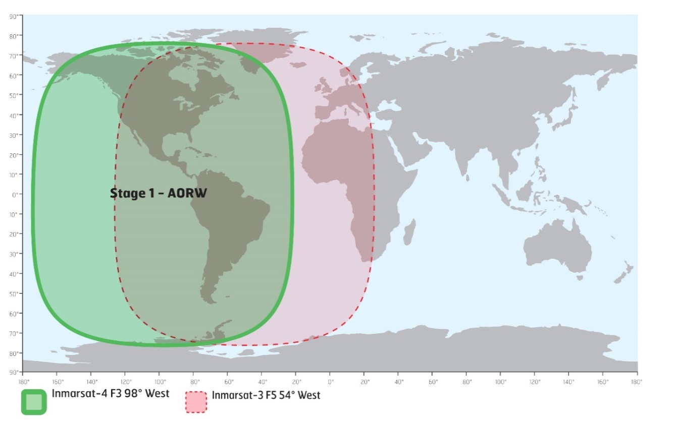
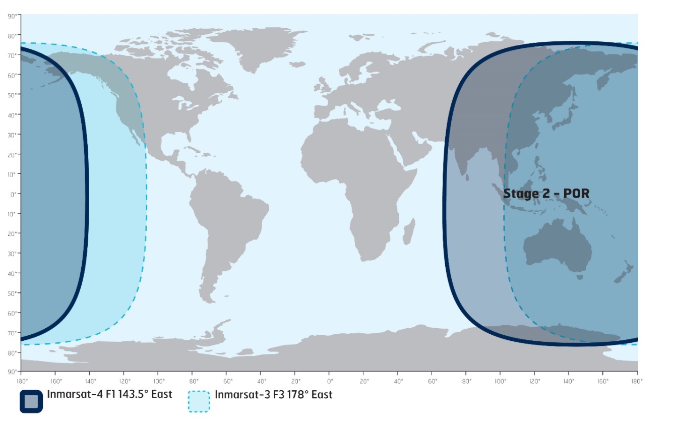
*316(T) MARINE COMMUNICATIONS AND TRAFFIC SERVICES – INMARSAT I-3 TO I-4 SATELLITE MIGRATION
The International Maritime Organization (IMO), the International Hydrographic Organization (IHO), and the World Meteorological Organization (WMO) inform the maritime community of the planned Inmarsat I-3 to I-4 satellite migration in 2018.
The services specific to the maritime sector include Inmarsat-C, Mini C, and Fleet77. These services have operated successfully over the I-4 satellites previously and therefore minimal service impact is anticipated. Inmarsat worked closely with Land Earth Station operators (LESOs), terminal manufacturers, administrations that provide Maritime Safety Information (MSI) and other stakeholders during the extensive preparation of the migration plan. Safety services will be restored first with the highest priority. The migration will have minimal impact on seafarers.
The migration will start in April 2018 and take approximately 9 months to complete. The approach of Inmarsat is to migrate these services satellite-by-satellite as illustrated below.
|
I-3 TO I-4 MIGRATION |
TIMELINES |
|---|---|
|
Atlantic Ocean Region West (AORW) I-3 to I-4 Americas (AMER) |
April 2018 |
|
Pacific Ocean Region (POR) I-3 to I-4 Asia/Pacific (APAC) |
July 2018 |
|
Atlantic Ocean Region East (AORE) I-3 moved to I-3 F5 |
September 2018 |
|
Indian Ocean Region (IOR) I-3 to I-4 Alphasat EMEA |
October 2018 |
Stage 1: AORW to AMER, April 2018
Stage 2: POR to APAC, July 2018
Stage 3: AORE to I-3 F5, September 2018

Stage 4: IOR to Alphasat EMEA, October 2018

Inmarsat will be communicating with you throughout the migration planning and execution phases, providing additional details as and when they become available. Further information can be found at https://www.inmarsat.com/i3-i4-services-migration. If you have any immediate questions or concerns, please contact Inmarsat at: maritime.safety@inmarsat.com.
*317 HARBOURS ON THE EAST SHORE OF LAKE SUPERIOR/PORTS SUR LA RIVE EST DU LAC SUPÉRIEUR – FOG HORN PERMANENTLY DISCONTINUED
Reference: Notice 607(P)/17 is cancelled (Chart 2315).
(D2018-001)
*319 RED DEER POINT TO/À NORTH MANITOU ISLAND – LIGHT PERMANENTLY DISCONTINUED
Reference: Notice 1008(P)/17 is cancelled (Chart 6272).
(A2018-006)
SECTION 2 - CHART CORRECTIONS
1233 - Cap aux Oies à/to Sault-au-Cochon - New Edition - 11-MAY-2012 - NAD 1983
| 09-MAR-2018 | LNM/D. 02-FEB-2018 | ||
| Add |
depth of 7 metres 5 decimetres (See Chart No. 1, I10) This notice affects Electronic Navigational Chart: CA479025 |
47°11′35.5″N 070°20′56.8″W | |
| DFO(6409765-18) |
1236 - Pointe des Monts aux/to Escoumins - New Edition - 26-OCT-2012 - NAD 1983
| 02-MAR-2018 | LNM/D. 24-NOV-2017 | ||
| Delete |
Limit of routeing measure (See Chart No. 1, M15) |
between 48°20′00.1″N 069°08′54.8″W and 48°59′13.3″N 067°41′14.4″W |
|
| DFO(6409756-01) | |||
| Add |
Limit of routeing measure (See Chart No. 1, M15) |
joining 48°20′00.1″N 069°08′54.8″W 48°26′03.6″N 068°58′17.6″W and 48°59′13.3″N 067°41′14.4″W |
|
| DFO(6409756-02) |
1236 - Port de Rimouski - New Edition - 26-OCT-2012 - NAD 1983
| 02-MAR-2018 | LNM/D. 24-NOV-2017 | ||
| Amend |
4,6 m (2016) to read 4,6 m (2017) (See Chart No. 1, I22) This notice affects Electronic Navigational Chart: CA579041 |
48°28′58.3″N 068°31′08.3″W | |
| DFO(6409757-03) | |||
| Delete |
depth of 5 metres 3 decimetres (See Chart No. 1, I10) This notice affects Electronic Navigational Chart: CA579041 |
48°28′52.3″N 068°31′07.8″W | |
| DFO(6409757-04) | |||
| Add |
depth of 5 metres 0 decimetres (See Chart No. 1, I10) This notice affects Electronic Navigational Chart: CA579041 |
48°28′52.6″N 068°31′07.9″W | |
| DFO(6409757-05) | |||
| Delete |
depth of 5 metres 4 decimetres (See Chart No. 1, I10) This notice affects Electronic Navigational Chart: CA579041 |
48°28′49.7″N 068°31′02.4″W | |
| DFO(6409757-06) | |||
| Add |
depth of 5 metres 0 decimetres (See Chart No. 1, I10) This notice affects Electronic Navigational Chart: CA579041 |
48°28′49.2″N 068°31′02.0″W | |
| DFO(6409757-07) | |||
| Add |
depth of 5 metres 0 decimetres (See Chart No. 1, I10) This notice affects Electronic Navigational Chart: CA579041 |
48°28′47.1″N 068°31′02.3″W | |
| DFO(6409757-08) | |||
| Delete |
depth of 5 metres 4 decimetres (See Chart No. 1, I10) This notice affects Electronic Navigational Chart: CA579041 |
48°28′47.2″N 068°31′00.0″W | |
| DFO(6409757-09) | |||
| Add |
depth of 5 metres 0 decimetres (See Chart No. 1, I10) This notice affects Electronic Navigational Chart: CA579041 |
48°28′47.1″N 068°31′00.2″W | |
| DFO(6409757-10) | |||
| Delete |
depth of 5 metres 5 decimetres (See Chart No. 1, I10) This notice affects Electronic Navigational Chart: CA579041 |
48°28′46.6″N 068°30′57.4″W | |
| DFO(6409757-11) | |||
| Add |
depth of 4 metres 9 decimetres (See Chart No. 1, I10) This notice affects Electronic Navigational Chart: CA579041 |
48°28′46.7″N 068°30′58.3″W | |
| DFO(6409757-12) | |||
| Add |
depth of 5 metres 0 decimetres (See Chart No. 1, I10) This notice affects Electronic Navigational Chart: CA579041 |
48°28′44.5″N 068°30′55.5″W | |
| DFO(6409757-13) | |||
| Delete |
depth of 4 metres 7 decimetres (See Chart No. 1, I10) This notice affects Electronic Navigational Chart: CA579041 |
48°28′55.5″N 068°31′09.4″W | |
| DFO(6409757-14) | |||
| Add |
depth of 4 metres 4 decimetres (See Chart No. 1, I10) This notice affects Electronic Navigational Chart: CA579041 |
48°28′56.1″N 068°31′09.2″W | |
| DFO(6409757-15) |
1236 - Rimouski - New Edition - 26-OCT-2012 - NAD 1983
| 02-MAR-2018 | LNM/D. 24-NOV-2017 | ||
| Amend |
4,6 m (2016) to read 4,6 m (2017) (See Chart No.1, I22) This notice affects Electronic Navigational Chart: CA579041 |
48°29′18.0″N 068°31′09.0″W | |
| DFO(6409757-01) | |||
| Add |
depth of 4 metres 3 decimetres (See Chart No. 1, I10) This notice affects Electronic Navigational Chart: CA579041 |
48°29′06.0″N 068°31′09.1″W | |
| DFO(6409757-02) | |||
| Delete |
depth of 4 metres 4 decimetres (See Chart No. 1, I10) This notice affects Electronic Navigational Chart: CA579041 |
48°29′05.0″N 068°31′07.5″W | |
| DFO(6409757-16) |
1310 - Jetée Alexandra - New Edition - 10-JAN-2014 - NAD 1983
| 16-MAR-2018 | LNM/D. 12-JAN-2018 | ||
| Amend |
3,5 m (2009) to read 3,5 m (2017) This notice affects Electronic Navigational Chart: CA579080 |
45°29′59.8″N 073°33′00.2″W | |
| DFO(6409764-07) |
1310 - Section B-C - New Edition - 10-JAN-2014 - NAD 1983
| 16-MAR-2018 | LNM/D. 12-JAN-2018 | ||
| Delete |
depth of 8 metres 7 decimetres (See Chart No. 1, I10) This notice affects Electronic Navigational Chart: CA579080 |
45°35′37.7″N 073°30′24.2″W | |
| DFO(6409764-01) | |||
| Add |
depth of 8 metres 4 decimetres (See Chart No. 1, I10) This notice affects Electronic Navigational Chart: CA579080 |
45°35′38.5″N 073°30′24.6″W | |
| DFO(6409764-02) | |||
| Delete |
depth of 7 metres 8 decimetres (See Chart No. 1, I10) This notice affects Electronic Navigational Chart: CA579080 |
45°30′43.3″N 073°32′52.6″W | |
| DFO(6409764-03) | |||
| Add |
depth of 7 metres 2 decimetres (See Chart No. 1, I10) This notice affects Electronic Navigational Chart: CA579080 |
45°30′43.4″N 073°32′52.9″W | |
| DFO(6409764-04) | |||
| Delete |
depth of 6 metres 6 decimetres (See Chart No. 1, I10) This notice affects Electronic Navigational Chart: CA579080 |
45°30′37.3″N 073°32′54.8″W | |
| DFO(6409764-05) | |||
| Add |
depth of 6 metres 2 decimetres (See Chart No. 1, I10) This notice affects Electronic Navigational Chart: CA579080 |
45°30′37.7″N 073°32′54.7″W | |
| DFO(6409764-06) |
1311 - Sorel-Tracy à/to Varennes - New Edition - 19-SEP-2013 - NAD 1983
| 16-MAR-2018 | LNM/D. 12-JAN-2018 | ||
| Amend |
F G 22m14M to read F G 29m14M against light (See Chart No. 1, P16) This notice affects Electronic Navigational Chart: CA479155 |
45°48′20.3″N 073°20′14.1″W | |
| (Q2017054) LL(2327) DFO(6409746-01) | |||
| Amend |
F G 13m14M to read F G 14m14M against light (See Chart No. 1, P16) This notice affects Electronic Navigational Chart: CA479155 |
45°47′56.4″N 073°20′40.5″W | |
| (Q2017055) LL(2326) DFO(6409747-01) |
1311 - Terminal de Contrecoeur - New Edition - 19-SEP-2013 - NAD 1983
| 16-MAR-2018 | LNM/D. 12-JAN-2018 | ||
| Delete |
depth of 8 metres 1 decimetre (See Chart No. 1, I10) This notice affects Electronic Navigational Chart: CA579156 |
45°49′47.8″N 073°17′15.3″W | |
| DFO(6409774-01) | |||
| Add |
depth of 7 metres 6 decimetres (See Chart No. 1, I10) This notice affects Electronic Navigational Chart: CA579156 |
45°49′47.6″N 073°17′15.4″W | |
| DFO(6409774-02) |
1312 - Lac Saint-Pierre - New Edition - 24-MAY-2013 - NAD 1983
| 23-MAR-2018 | LNM/D. 16-FEB-2018 | ||
| Affix |
patch Download Patch - ftp://ftp.dfo-mpo.gc.ca/patches/pa1312a-20180226.pdf This notice affects Electronic Navigational Chart: CA479129 |
46°16′36.0″N 072°43′00.0″W | |
| DFO(6409684-01) | |||
| Affix |
patch Download Patch - ftp://ftp.dfo-mpo.gc.ca/patches/pa1312b-20180226.pdf This notice affects Electronic Navigational Chart: CA479129 |
46°16′36.0″N 072°38′51.5″W | |
| DFO(6409686-01) |
1315 - Mouillage Saint-Nicolas - New Edition - 27-APR-2012 - NAD 1983
| 23-MAR-2018 | LNM/D. 16-FEB-2018 | ||
| Delete |
depth of 11 metres 9 decimetres (See Chart No. 1, I10) This notice affects Electronic Navigational Chart: CA579224 |
46°43′21.0″N 071°23′32.7″W | |
| DFO(6409775-03) | |||
| Add |
depth of 11 metres 2 decimetres (See Chart No. 1, I10) This notice affects Electronic Navigational Chart: CA479020, CA579224 |
46°43′19.3″N 071°23′33.6″W | |
| DFO(6409775-04) |
1315 - Québec à/to Donnacona - New Edition - 27-APR-2012 - NAD 1983
| 23-MAR-2018 | LNM/D. 16-FEB-2018 | ||
| Affix |
patch Download Patch - ftp://ftp.dfo-mpo.gc.ca/patches/pa1315a-20180226.pdf |
46°38′52.0″N 071°42′54.0″W | |
| DFO(6409683-01) | |||
| Add |
depth of 10 metres 1 decimetre (See Chart No. 1, I10) This notice affects Electronic Navigational Chart: CA479020 |
46°43′15.3″N 071°24′07.6″W | |
| DFO(6409775-01) | |||
| Add |
depth of 7 metres 5 decimetres (See Chart No. 1, I10) This notice affects Electronic Navigational Chart: CA479020 |
46°43′30.6″N 071°24′07.5″W | |
| DFO(6409775-02) | |||
| Add |
depth of 11 metres 2 decimetres (See Chart No. 1, I10) This notice affects Electronic Navigational Chart: CA479020, CA579224 |
46°43′19.3″N 071°23′33.6″W | |
| DFO(6409775-04) |
1316 - Port de Québec - New Edition - 02-DEC-2011 - NAD 1983
| 09-MAR-2018 | LNM/D. 16-FEB-2018 | ||
| Add |
depth of 4 metres 1 decimetre (See Chart No. 1, I10) This notice affects Electronic Navigational Chart: CA479082, CA579003 |
46°51′39.5″N 071°08′45.3″W | |
| DFO(6409762-02) | |||
| Add |
depth of 4 metres 7 decimetres (See Chart No. 1, I10) This notice affects Electronic Navigational Chart: CA579003 |
46°50′58.2″N 071°08′48.6″W | |
| DFO(6409762-19) | |||
| Delete |
depth of 16 metres 1 decimetre (See Chart No. 1, I10) This notice affects Electronic Navigational Chart: CA579003 |
46°51′15.5″N 071°08′53.4″W | |
| DFO(6409762-20) | |||
| Add |
depth of 15 metres 3 decimetres (See Chart No. 1, I10) This notice affects Electronic Navigational Chart: CA579003 |
46°51′15.9″N 071°08′53.5″W | |
| DFO(6409762-21) | |||
| Delete |
depth of 10 metres 2 decimetres (See Chart No. 1, I10) This notice affects Electronic Navigational Chart: CA579003 |
46°50′15.4″N 071°09′07.4″W | |
| DFO(6409765-01) | |||
| Add |
depth of 9 metres 6 decimetres (See Chart No. 1, I10) This notice affects Electronic Navigational Chart: CA479082, CA579003 |
46°50′15.2″N 071°09′07.2″W | |
| DFO(6409765-03) | |||
| Delete |
depth of 10 metres 5 decimetres (See Chart No. 1, I10) This notice affects Electronic Navigational Chart: CA579003 |
46°50′08.7″N 071°09′10.9″W | |
| DFO(6409765-04) | |||
| Add |
depth of 9 metres 8 decimetres (See Chart No. 1, I10) This notice affects Electronic Navigational Chart: CA579003 |
46°50′09.4″N 071°09′10.6″W | |
| DFO(6409765-05) | |||
| Delete |
depth of 9 metres 7 decimetres (See Chart No. 1, I10) This notice affects Electronic Navigational Chart: CA479082, CA579003 |
46°50′16.6″N 071°08′52.3″W | |
| DFO(6409765-06) | |||
| Add |
depth of 9 metres 2 decimetres (See Chart No. 1, I10) This notice affects Electronic Navigational Chart: CA479082, CA579003 |
46°50′16.0″N 071°08′52.7″W | |
| DFO(6409765-07) | |||
| Delete |
depth of 12 metres 0 decimetres (See Chart No. 1, I10) This notice affects Electronic Navigational Chart: CA579003 |
46°50′16.9″N 071°08′37.6″W | |
| DFO(6409765-08) | |||
| Add |
depth of 10 metres 6 decimetres (See Chart No. 1, I10) This notice affects Electronic Navigational Chart: CA579003 |
46°50′16.1″N 071°08′38.8″W | |
| DFO(6409765-09) | |||
| Delete |
depth of 10 metres 7 decimetres (See Chart No. 1, I10) This notice affects Electronic Navigational Chart: CA579003 |
46°50′11.4″N 071°08′42.4″W | |
| DFO(6409765-10) | |||
| Add |
depth of 10 metres 0 decimetres (See Chart No. 1, I10) This notice affects Electronic Navigational Chart: CA579003 |
46°50′10.8″N 071°08′43.0″W | |
| DFO(6409765-11) | |||
| Delete |
depth of 12 metres 0 decimetres (See Chart No. 1, I10) This notice affects Electronic Navigational Chart: CA579003 |
46°50′04.1″N 071°08′20.9″W | |
| DFO(6409765-12) | |||
| Add |
depth of 10 metres 9 decimetres (See Chart No. 1, I10) This notice affects Electronic Navigational Chart: CA579003 |
46°50′03.2″N 071°08′20.1″W | |
| DFO(6409765-13) | |||
| Delete |
depth of 13 metres 0 decimetres (See Chart No. 1, I10) This notice affects Electronic Navigational Chart: CA579003 |
46°50′12.6″N 071°08′04.7″W | |
| DFO(6409765-14) | |||
| Add |
depth of 12 metres 4 decimetres (See Chart No. 1, I10) This notice affects Electronic Navigational Chart: CA579003 |
46°50′12.1″N 071°08′04.9″W | |
| DFO(6409765-15) | |||
| Add |
depth of 9 metres 8 decimetres (See Chart No. 1, I10) This notice affects Electronic Navigational Chart: CA479082, CA579003 |
46°50′07.1″N 071°07′59.8″W | |
| DFO(6409765-16) |
1317 - Sault-au-Cochon à/to Québec - New Edition - 22-JUN-2012 - NAD 1983
| 09-MAR-2018 | LNM/D. 16-FEB-2018 | ||
| Delete |
depth of 3 metres 6 decimetres (See Chart No. 1, I10) This notice affects Electronic Navigational Chart: CA479025 |
46°54′35.2″N 070°49′56.4″W | |
| DFO(6409762-07) | |||
| Add |
depth of 2 metres 7 decimetres (See Chart No. 1, I10) This notice affects Electronic Navigational Chart: CA479025 |
46°54′35.6″N 070°49′59.1″W | |
| DFO(6409762-08) | |||
| Delete |
depth of 2 metres 7 decimetres (See Chart No. 1, I10) This notice affects Electronic Navigational Chart: CA479025 |
46°54′15.3″N 070°49′53.2″W | |
| DFO(6409762-09) | |||
| Add |
depth of 2 metres 0 decimetres (See Chart No. 1, I10) This notice affects Electronic Navigational Chart: CA479025 |
46°54′15.7″N 070°49′53.0″W | |
| DFO(6409762-10) | |||
| Add |
depth of 1 metre 8 decimetres (See Chart No. 1, I10) This notice affects Electronic Navigational Chart: CA479025 |
46°56′16.0″N 070°49′49.5″W | |
| DFO(6409762-11) | |||
| Add |
depth of 3 metres 0 decimetres (See Chart No. 1, I10) This notice affects Electronic Navigational Chart: CA479025 |
46°56′25.9″N 070°49′11.0″W | |
| DFO(6409762-12) | |||
| Delete |
depth of 6 metres 9 decimetres (See Chart No. 1, I10) This notice affects Electronic Navigational Chart: CA479025 |
46°56′32.8″N 070°50′23.1″W | |
| DFO(6409762-13) | |||
| Add |
depth of 6 metres 2 decimetres (See Chart No. 1, I10) This notice affects Electronic Navigational Chart: CA479025 |
46°56′33.6″N 070°50′20.9″W | |
| DFO(6409762-14) | |||
| Add |
depth of 4 metres 8 decimetres (See Chart No. 1, I10) This notice affects Electronic Navigational Chart: CA479025 |
46°57′00.5″N 070°50′01.9″W | |
| DFO(6409762-15) | |||
| Delete |
depth of 7 metres 6 decimetres (See Chart No. 1, I10) This notice affects Electronic Navigational Chart: CA479025 |
46°57′29.9″N 070°49′38.3″W | |
| DFO(6409762-16) | |||
| Add |
depth of 7 metres 0 decimetres (See Chart No. 1, I10) This notice affects Electronic Navigational Chart: CA479025 |
46°57′30.5″N 070°49′37.0″W | |
| DFO(6409762-17) | |||
| Add |
depth of 1 metre 8 decimetres (See Chart No. 1, I10) This notice affects Electronic Navigational Chart: CA479025 |
46°57′40.9″N 070°48′41.1″W | |
| DFO(6409762-18) | |||
| Delete |
depth of 7 metres 4 decimetres (See Chart No. 1, I10) This notice affects Electronic Navigational Chart: CA479025 |
47°01′00.9″N 070°37′28.9″W | |
| DFO(6409763-01) | |||
| Add |
depth of 6 metres 5 decimetres (See Chart No. 1, I10) This notice affects Electronic Navigational Chart: CA479025 |
47°01′01.2″N 070°37′31.1″W | |
| DFO(6409763-02) | |||
| Delete |
depth of 7 metres 8 decimetres (See Chart No. 1, I10) This notice affects Electronic Navigational Chart: CA479025 |
47°01′06.9″N 070°35′48.5″W | |
| DFO(6409763-03) | |||
| Add |
depth of 6 metres 9 decimetres (See Chart No. 1, I10) This notice affects Electronic Navigational Chart: CA479025 |
47°01′08.6″N 070°35′45.3″W | |
| DFO(6409763-04) | |||
| Delete |
depth of 4 metres 4 decimetres (See Chart No. 1, I10) This notice affects Electronic Navigational Chart: CA479025 |
47°01′06.3″N 070°34′57.4″W | |
| DFO(6409763-05) | |||
| Add |
depth of 4 metres 0 decimetres (See Chart No. 1, I10) This notice affects Electronic Navigational Chart: CA479025 |
47°01′06.7″N 070°34′57.6″W | |
| DFO(6409763-06) | |||
| Delete |
depth of 9 metres 1 decimetre (See Chart No. 1, I10) This notice affects Electronic Navigational Chart: CA479025 |
47°01′34.7″N 070°34′49.9″W | |
| DFO(6409763-07) | |||
| Add |
depth of 7 metres 6 decimetres (See Chart No. 1, I10) This notice affects Electronic Navigational Chart: CA479025 |
47°01′35.1″N 070°34′48.9″W | |
| DFO(6409763-08) | |||
| Delete |
depth of 9 metres 0 decimetres (See Chart No. 1, I10) This notice affects Electronic Navigational Chart: CA479025 |
47°02′02.1″N 070°32′47.6″W | |
| DFO(6409763-09) | |||
| Add |
depth of 6 metres 2 decimetres (See Chart No. 1, I10) This notice affects Electronic Navigational Chart: CA479025 |
47°02′00.0″N 070°32′45.4″W | |
| DFO(6409763-10) | |||
| Delete |
depth of 3 metres 9 decimetres (See Chart No. 1, I10) This notice affects Electronic Navigational Chart: CA479025 |
47°01′54.1″N 070°32′06.6″W | |
| DFO(6409763-11) | |||
| Add |
depth of 3 metres 6 decimetres (See Chart No. 1, I10) This notice affects Electronic Navigational Chart: CA479025 |
47°01′53.8″N 070°32′07.5″W | |
| DFO(6409763-12) | |||
| Delete |
depth of 6 metres 2 decimetres (See Chart No. 1, I10) This notice affects Electronic Navigational Chart: CA479025 |
47°02′05.4″N 070°32′06.6″W | |
| DFO(6409763-13) | |||
| Add |
depth of 4 metres 6 decimetres (See Chart No. 1, I10) This notice affects Electronic Navigational Chart: CA479025 |
47°02′05.8″N 070°32′02.1″W | |
| DFO(6409763-14) | |||
| Add |
depth of 6 metres 7 decimetres (See Chart No. 1, I10) This notice affects Electronic Navigational Chart: CA479025 |
47°09′33.9″N 070°29′02.0″W | |
| DFO(6409765-17) | |||
| Add |
depth of 7 metres 5 decimetres (See Chart No. 1, I10) This notice affects Electronic Navigational Chart: CA479025 |
47°11′35.5″N 070°20′56.8″W | |
| DFO(6409765-18) | |||
| 30-MAR-2018 | LNM/D. 09-MAR-2018 | ||
| Add |
depth of 11 metres 3 decimetres (See Chart No. 1, I10) This notice affects Electronic Navigational Chart: CA479025 |
46°53′09.2″N 070°56′06.3″W | |
| DFO(6409782-03) | |||
| Add |
depth of 10 metres 4 decimetres (See Chart No. 1, I10) This notice affects Electronic Navigational Chart: CA479025 |
46°53′14.3″N 070°56′00.4″W | |
| DFO(6409782-04) | |||
| Delete |
depth of 16 metres 6 decimetres (See Chart No. 1, I10) This notice affects Electronic Navigational Chart: CA479025 |
46°53′46.1″N 070°54′58.6″W | |
| DFO(6409782-05) | |||
| Add |
depth of 16 metres 0 decimetres (See Chart No. 1, I10) This notice affects Electronic Navigational Chart: CA479025 |
46°53′45.9″N 070°54′58.6″W | |
| DFO(6409782-06) | |||
| Delete |
depth of 18 metres 0 decimetres (See Chart No. 1, I10) This notice affects Electronic Navigational Chart: CA479025 |
46°53′53.3″N 070°54′37.7″W | |
| DFO(6409782-07) | |||
| Add |
depth of 17 metres 1 decimetre (See Chart No. 1, I10) This notice affects Electronic Navigational Chart: CA479025 |
46°53′55.0″N 070°54′36.1″W | |
| DFO(6409782-08) | |||
| Add |
depth of 10 metres 3 decimetres (See Chart No. 1, I10) This notice affects Electronic Navigational Chart: CA479025 |
47°02′11.4″N 070°45′53.1″W | |
| DFO(6409782-09) | |||
| Delete |
depth of 4 metres 2 decimetres (See Chart No. 1, I10) This notice affects Electronic Navigational Chart: CA479025 |
47°03′22.5″N 070°43′04.2″W | |
| DFO(6409782-10) | |||
| Add |
depth of 3 metres 0 decimetres (See Chart No. 1, I10) This notice affects Electronic Navigational Chart: CA479025 |
47°03′22.0″N 070°43′02.3″W | |
| DFO(6409782-11) | |||
| Add |
depth of 2 metres 0 decimetres (See Chart No. 1, I10) This notice affects Electronic Navigational Chart: CA479025 |
47°03′22.1″N 070°42′43.1″W | |
| DFO(6409782-12) | |||
| Add |
depth of 2 metres 2 decimetres (See Chart No. 1, I10) This notice affects Electronic Navigational Chart: CA479025 |
47°03′28.5″N 070°42′25.5″W | |
| DFO(6409782-13) |
1317 - Continuation A - New Edition - 22-JUN-2012 - NAD 1983
| 09-MAR-2018 | LNM/D. 16-FEB-2018 | ||
| Delete |
depth of 6 metres 2 decimetres (See Chart No. 1, I10) This notice affects Electronic Navigational Chart: CA479082 |
46°51′36.4″N 071°08′44.1″W | |
| DFO(6409762-01) | |||
| Add |
depth of 4 metres 1 decimetre (See Chart No. 1, I10) This notice affects Electronic Navigational Chart: CA479082, CA579003 |
46°51′39.5″N 071°08′45.3″W | |
| DFO(6409762-02) | |||
| Delete |
depth of 3 metres 4 decimetres (See Chart No. 1, I10) This notice affects Electronic Navigational Chart: CA479082 |
46°56′09.1″N 071°02′14.3″W | |
| DFO(6409762-03) | |||
| Add |
depth of 2 metres 8 decimetres (See Chart No. 1, I10) This notice affects Electronic Navigational Chart: CA479082 |
46°56′09.1″N 071°02′16.7″W | |
| DFO(6409762-04) | |||
| Add |
depth of 4 metres 6 decimetres (See Chart No. 1, I10) This notice affects Electronic Navigational Chart: CA479082 |
46°57′29.3″N 071°00′11.9″W | |
| DFO(6409762-05) | |||
| Add |
depth of 4 metres 2 decimetres (See Chart No. 1, I10) This notice affects Electronic Navigational Chart: CA479082 |
46°58′04.9″N 070°59′22.3″W | |
| DFO(6409762-06) | |||
| Delete |
depth of 11 metres 1 decimetre (See Chart No. 1, I10) This notice affects Electronic Navigational Chart: CA479082 |
46°50′17.5″N 071°09′05.8″W | |
| DFO(6409765-02) | |||
| Add |
depth of 9 metres 6 decimetres (See Chart No. 1, I10) This notice affects Electronic Navigational Chart: CA479082, CA579003 |
46°50′15.2″N 071°09′07.2″W | |
| DFO(6409765-03) | |||
| Delete |
depth of 9 metres 7 decimetres (See Chart No. 1, I10) This notice affects Electronic Navigational Chart: CA479082, CA579003 |
46°50′16.6″N 071°08′52.3″W | |
| DFO(6409765-06) | |||
| Add |
depth of 9 metres 2 decimetres (See Chart No. 1, I10) This notice affects Electronic Navigational Chart: CA479082, CA579003 |
46°50′16.0″N 071°08′52.7″W | |
| DFO(6409765-07) | |||
| Add |
depth of 9 metres 8 decimetres (See Chart No. 1, I10) This notice affects Electronic Navigational Chart: CA479082, CA579003 |
46°50′07.1″N 071°07′59.8″W | |
| DFO(6409765-16) | |||
| 30-MAR-2018 | LNM/D. 09-MAR-2018 | ||
| Delete |
depth of 16 metres 3 decimetres (See Chart No. 1, I10) This notice affects Electronic Navigational Chart: CA479082 |
46°52′06.0″N 070°58′11.5″W | |
| DFO(6409782-01) | |||
| Add |
depth of 15 metres 2 decimetres (See Chart No. 1, I10) This notice affects Electronic Navigational Chart: CA479082 |
46°52′07.1″N 070°58′09.8″W | |
| DFO(6409782-02) | |||
| Add |
depth of 11 metres 3 decimetres (See Chart No. 1, I10) This notice affects Electronic Navigational Chart: CA479025 |
46°53′09.2″N 070°56′06.3″W | |
| DFO(6409782-03) | |||
| Add |
depth of 10 metres 4 decimetres (See Chart No. 1, I10) This notice affects Electronic Navigational Chart: CA479025 |
46°53′14.3″N 070°56′00.4″W | |
| DFO(6409782-04) | |||
| Delete |
depth of 16 metres 6 decimetres (See Chart No. 1, I10) This notice affects Electronic Navigational Chart: CA479025 |
46°53′46.1″N 070°54′58.6″W | |
| DFO(6409782-05) | |||
| Add |
depth of 16 metres 0 decimetres (See Chart No. 1, I10) This notice affects Electronic Navigational Chart: CA479025 |
46°53′45.9″N 070°54′58.6″W | |
| DFO(6409782-06) | |||
| Delete |
depth of 18 metres 0 decimetres (See Chart No. 1, I10) This notice affects Electronic Navigational Chart: CA479025 |
46°53′53.3″N 070°54′37.7″W | |
| DFO(6409782-07) | |||
| Add |
depth of 17 metres 1 decimetre (See Chart No. 1, I10) This notice affects Electronic Navigational Chart: CA479025 |
46°53′55.0″N 070°54′36.1″W | |
| DFO(6409782-08) |
1360 - Magog - New Chart - 23-MAY-2014 - NAD 1983
| 23-MAR-2018 | LNM/D. 30-JUN-2017 | ||
| Reposition |
red starboard hand conical buoy, marked K4 (See Chart No. 1, Qf) This notice affects Electronic Navigational Chart: CA579241 |
from 45°15′56.4″N 072°09′15.9″W to 45°15′55.9″N 072°09′14.0″W |
|
| (Q2018009) DFO(6409768-01) | |||
| Reposition |
green port hand can buoy, marked K5 (See Chart No. 1, Qg) This notice affects Electronic Navigational Chart: CA579241 |
from 45°15′55.8″N 072°09′16.2″W to 45°15′55.7″N 072°09′14.6″W |
|
| (Q2018010) DFO(6409769-01) | |||
| Reposition |
green port hand can buoy, marked K7 (See Chart No. 1, Qg) This notice affects Electronic Navigational Chart: CA579241 |
from 45°15′55.9″N 072°09′22.7″W to 45°15′55.7″N 072°09′23.0″W |
|
| (Q2018011) DFO(6409770-01) |
2054 - Cobourg Harbour - New Chart - 10-MAY-1985 - NAD 1927
| 09-MAR-2018 | LNM/D. 05-DEC-2003 | ||
| Add |
sounding of 2.3 metres, Rep (2017) (See Chart No. 1, I10) |
43°57′06.7″N 078°09′54.4″W | |
| DFO(6604382-01) |
2300 - Lake Superior/Lac Supérieur - New Chart - 24-APR-1998 - NAD 1983
| 09-MAR-2018 | LNM/D. 13-NOV-2015 | ||
| Delete |
fog signal Fog Sig (MAN) (See Chart No. 1, R1, R20) This notice affects Electronic Navigational Chart: CA373086, CA573136 |
47°40′28.8″N 085°48′10.8″W | |
| (D2018001) LL(1098) DFO(6604383-01) |
2308 - Michipicoten Island to/à Oiseau Bay - New Edition - 22-SEP-2006 - NAD 1983
| 09-MAR-2018 | LNM/D. 31-MAY-2013 | ||
| Delete |
fog signal Fog Sig (MAN) (See Chart No. 1, R1, R20) This notice affects Electronic Navigational Chart: CA373086, CA573136 |
47°41′48.1″N 085°48′05.2″W | |
| (D2018001) LL(1098) DFO(6604383-01) |
2309 - Cape Gargantua to/à Otter Head - New Edition - 23-JUL-1999 - NAD 1983
| 09-MAR-2018 | LNM/D. 15-DEC-2017 | ||
| Delete |
fog signal Fog Sig (2) 60s (MAN) (See Chart No. 1, R1, R20) This notice affects Electronic Navigational Chart: CA373086, CA573136 |
47°40′38.7″N 085°48′57.5″W | |
| (D2018001) LL(1098) DFO(6604383-01) |
2310 - Caribou Island to Michipicoten Island - New Edition - 29-MAY-2015 - US Standard Datum
| 09-MAR-2018 | |||
| Delete |
fog signal Fog Sig (2) 60s (MAN) (See Chart No. 1, R1, R20) This notice affects Electronic Navigational Chart: CA373086, CA573136 |
47°40′42.5″N 085°49′28.6″W | |
| (D2018001) LL(1098) DFO(6604383-01) |
2315 - Quebec Harbour - New Edition - 07-JUL-2006 - NAD 1983
| 09-MAR-2018 | LNM/D. 15-DEC-2017 | ||
| Delete |
fog signal Fog Sig (2) 60s (MAN) (See Chart No. 1, R1, R20) This notice affects Electronic Navigational Chart: CA373086, CA573136 |
47°41′44.0″N 085°48′23.1″W | |
| (D2018001) LL(1098) DFO(6604383-01) |
4002 - Golfe du Saint-Laurent / Gulf of St. Lawrence - New Edition - 30-OCT-2015 - NAD 1983
| 23-MAR-2018 | LNM/D. 29-DEC-2017 | ||
| Replace |
depth of 3 metres, 4 decimetres with depth of 2 metres, 6
decimetres (See Chart No. 1, I10) This notice affects Electronic Navigational Chart: CA179245 |
45°47′47.3″N 062°38′19.7″W | |
| DFO(6308162-18) |
4013 - Halifax to / à Sydney - New Edition - 06-SEP-2002 - NAD 1983
| 23-MAR-2018 | LNM/D. 06-OCT-2017 | ||
| Replace |
depth of 1 fathom, 5 feet with depth of 1 fathom, 3
feet (See Chart No. 1, I10) This notice affects Electronic Navigational Chart: CA179245 |
45°47′47.3″N 062°38′19.7″W | |
| DFO(6308162-18) | |||
| Replace |
depth of 4 fathoms, 3 feet with depth of 3 fathoms, 5
feet (See Chart No. 1, I10) This notice affects Electronic Navigational Chart: CA276286, CA376691 |
45°47′30.1″N 062°42′40.8″W | |
| DFO(6308162-19) | |||
| Replace |
depth of 1 fathom, 5 feet with depth of 1 fathom (See Chart No. 1, I10) This notice affects Electronic Navigational Chart: CA276286 |
45°46′09.7″N 062°41′24.6″W | |
| DFO(6308162-21) | |||
| Replace |
depth of 1 fathom, 3 feet with depth of 0 fathoms, 4
feet (See Chart No. 1, I10) This notice affects Electronic Navigational Chart: CA276286 |
45°44′25.5″N 062°44′17.8″W | |
| DFO(6308162-22) | |||
| Replace |
depth of 3 fathoms, 5 feet with depth of 0 fathoms, 5
feet (See Chart No. 1, I10) This notice affects Electronic Navigational Chart: CA276286 |
45°44′23.6″N 062°42′41.5″W | |
| DFO(6308162-24) | |||
| Delete |
depth of 4 fathoms, 3 feet (See Chart No. 1, I10) |
45°44′54.7″N 062°34′58.9″W | |
| DFO(6308162-47) | |||
| Add |
depth of 3 fathoms, 4 feet (See Chart No. 1, I10) This notice affects Electronic Navigational Chart: CA276286, CA376691 |
45°44′56.0″N 062°34′25.1″W | |
| DFO(6308162-48) |
4023 - Northumberland Strait / Détroit de Northumberland - New Edition - 27-DEC-2002 - NAD 1983
| 23-MAR-2018 | LNM/D. 16-FEB-2018 | ||
| Add |
depth of 1 fathom, 3 feet (See Chart No. 1, I10) This notice affects Electronic Navigational Chart: CA276286, CA376691, CA576464 |
45°47′47.3″N 062°38′19.7″W | |
| DFO(6308162-01) | |||
| Add |
depth of 1 fathom, 2 feet (See Chart No. 1, I10) This notice affects Electronic Navigational Chart: CA276286, CA376691, CA576464 |
45°46′12.2″N 062°42′29.9″W | |
| DFO(6308162-06) | |||
| Replace |
depth of 4 fathoms, 3 feet with depth of 3 fathoms, 5
feet (See Chart No. 1, I10) This notice affects Electronic Navigational Chart: CA276286, CA376691 |
45°47′30.1″N 062°42′40.8″W | |
| DFO(6308162-19) | |||
| Replace |
depth of 1 fathom, 5 feet with depth of 1 fathom (See Chart No. 1, I10) This notice affects Electronic Navigational Chart: CA276286 |
45°46′09.7″N 062°41′24.6″W | |
| DFO(6308162-21) | |||
| Replace |
depth of 1 fathom, 3 feet with depth of 0 fathoms, 4
feet (See Chart No. 1, I10) This notice affects Electronic Navigational Chart: CA276286 |
45°44′25.5″N 062°44′17.8″W | |
| DFO(6308162-22) | |||
| Replace |
depth of 3 fathoms, 5 feet with depth of 0 fathoms, 5
feet (See Chart No. 1, I10) This notice affects Electronic Navigational Chart: CA276286 |
45°44′23.6″N 062°42′41.5″W | |
| DFO(6308162-24) | |||
| Add |
depth of 3 fathoms, 4 feet (See Chart No. 1, I10) This notice affects Electronic Navigational Chart: CA276286, CA376691 |
45°44′56.0″N 062°34′25.1″W | |
| DFO(6308162-48) |
4024 - Baie des Chaleurs/Chaleur Bay aux/to Îles de la Madeleine - New Edition - 06-MAR-2015 - NAD 1983
| 02-MAR-2018 | LNM/D. 22-DEC-2017 | ||
| Add |
depth of 4 metres 9 decimetres (See Chart No. 1, I10) This notice affects Electronic Navigational Chart: CA279075 |
48°07′56.5″N 065°52′36.7″W | |
| DFO(6409758-01) |
4116 - Approaches to / Approches à Saint John - New Edition - 31-AUG-2007 - NAD 1983
| 30-MAR-2018 | LNM/D. 29-DEC-2017 | ||
| Replace |
jetty with jetty in ruins with legend Ru (See Chart No. 1, F33) This notice affects Electronic Navigational Chart: CA376011 |
joining 45°06′57.9″N 066°28′38.4″W 45°07′02.0″N 066°28′44.5″W 45°07′03.7″N 066°28′44.7″W 45°07′03.8″N 066°28′45.7″W 45°07′01.8″N 066°28′45.6″W and 45°06′57.1″N 066°28′39.0″W |
|
| DFO(6308225-01) |
4203 - Halifax Harbour: Black Point to / à Point Pleasant - New Edition - 14-APR-2000 - NAD 1983
| 16-MAR-2018 | LNM/D. 17-NOV-2017 | ||
| Delete |
ON CERTAIN COPIES red limit in general (See Chart No. 1, M4) |
joining 44°35′36.4″N 063°33′16.0″W 44°34′51.0″N 063°33′16.0″W 44°34′51.0″N 063°32′04.3″W 44°35′36.4″N 063°32′04.3″W and 44°35′36.4″N 063°33′16.0″W |
|
| DFO(6308223-01) |
4386 - Head Harbour - New Edition - 16-JUL-2004 - NAD 1983
| 30-MAR-2018 | LNM/D. 30-JUN-2017 | ||
| Add |
depth of 2 metres, 9 decimetres (See Chart No. 1, I10) This notice affects Electronic Navigational Chart: CA476196 |
44°39′16.9″N 063°57′16.7″W | |
| DFO(6307923-01) | |||
| Add |
depth of 4 metres, 3 decimetres (See Chart No. 1, I10) This notice affects Electronic Navigational Chart: CA476196 |
44°38′00.3″N 063°55′09.6″W | |
| DFO(6307923-02) | |||
| Replace |
depth of 6 metres, 4 decimetres with depth of 4 metres, 8
decimetres (See Chart No. 1, I10) This notice affects Electronic Navigational Chart: CA476196 |
44°39′18.7″N 063°56′35.1″W | |
| DFO(6307923-03) | |||
| Add |
depth of 4 metres, 2 decimetres (See Chart No. 1, I10) This notice affects Electronic Navigational Chart: CA476196 |
44°39′42.1″N 063°54′36.6″W | |
| DFO(6307923-04) | |||
| Add |
marine farm limits (See Chart No. 1, K48.1) This notice affects Electronic Navigational Chart: CA476196 |
joining 44°37′48.3″N 063°55′20.4″W 44°37′54.1″N 063°55′21.4″W 44°37′56.8″N 063°55′23.4″W 44°37′55.2″N 063°55′32.4″W 44°37′50.4″N 063°55′31.9″W 44°37′47.5″N 063°55′28.3″W and 44°37′48.2″N 063°55′20.7″W |
|
| DFO(6308222-01) |
4404 - Cape George to / à Pictou - New Edition - 28-FEB-2014 - NAD 1983
| 23-MAR-2018 | LNM/D. 11-AUG-2017 | ||
| Add |
depth of 2 metres, 6 decimetres (See Chart No. 1, I10) This notice affects Electronic Navigational Chart: CA276286, CA376691, CA576464 |
45°47′47.3″N 062°38′19.7″W | |
| DFO(6308162-01) | |||
| Add |
depth of 1 metre, 7 decimetres (See Chart No. 1, I10) This notice affects Electronic Navigational Chart: CA376691, CA576464 |
45°46′09.7″N 062°41′24.6″W | |
| DFO(6308162-05) | |||
| Add |
depth of 2 metres, 3 decimetres (See Chart No. 1, I10) This notice affects Electronic Navigational Chart: CA276286, CA376691, CA576464 |
45°46′12.2″N 062°42′29.9″W | |
| DFO(6308162-06) | |||
| Add |
depth of 1 metre, 3 decimetres (See Chart No. 1, I10) This notice affects Electronic Navigational Chart: CA376691, CA576464 |
45°44′25.5″N 062°44′17.8″W | |
| DFO(6308162-07) | |||
| Add |
depth of 1 metre, 5 decimetres (See Chart No. 1, I10) This notice affects Electronic Navigational Chart: CA376691, CA576464 |
45°44′23.6″N 062°42′41.5″W | |
| DFO(6308162-09) | |||
| Add |
depth of 1 metre, 4 decimetres (See Chart No. 1, I10) This notice affects Electronic Navigational Chart: CA376691, CA576464 |
45°44′54.2″N 062°41′47.0″W | |
| DFO(6308162-11) | |||
| Add |
drying height of 0 metres, 6 decimetres (See Chart No. 1, I15) This notice affects Electronic Navigational Chart: CA376691, CA576464 |
45°44′00.1″N 062°38′44.1″W | |
| DFO(6308162-16) | |||
| Add |
depth of 0 metres, 6 decimetres (See Chart No. 1, I10) This notice affects Electronic Navigational Chart: CA376691, CA576464 |
45°44′20.6″N 062°38′34.8″W | |
| DFO(6308162-17) | |||
| Replace |
depth of 8 metres, 2 decimetres with depth of 6 metres, 9
decimetres (See Chart No. 1, I10) This notice affects Electronic Navigational Chart: CA276286, CA376691 |
45°47′30.1″N 062°42′40.8″W | |
| DFO(6308162-19) | |||
| Replace |
depth of 7 metres, 6 decimetres with depth of 5 metres, 9
decimetres (See Chart No. 1, I10) This notice affects Electronic Navigational Chart: CA376691 |
45°46′16.2″N 062°38′41.0″W | |
| DFO(6308162-20) | |||
| Add |
depth of 0 metres, 3 decimetres (See Chart No. 1, I10) This notice affects Electronic Navigational Chart: CA376691 |
45°44′41.3″N 062°42′40.7″W | |
| DFO(6308162-23) | |||
| Add |
drying height of 0 metres, 2 decimetres (See Chart No. 1, I15) This notice affects Electronic Navigational Chart: CA376691 |
45°45′05.1″N 062°41′05.7″W | |
| DFO(6308162-25) | |||
| Add |
depth of 0 metres, 6 decimetres (See Chart No. 1, I10) This notice affects Electronic Navigational Chart: CA376691 |
45°44′55.5″N 062°39′49.9″W | |
| DFO(6308162-26) | |||
| Replace |
depth of 5 metres, 8 decimetres with depth of 0 metres, 3
decimetres (See Chart No. 1, I10) This notice affects Electronic Navigational Chart: CA376691 |
45°43′45.8″N 062°39′41.5″W | |
| DFO(6308162-27) | |||
| Replace |
depth of 7 metres, 3 decimetres with depth of 3
metres (See Chart No. 1, I10) This notice affects Electronic Navigational Chart: CA376691 |
45°49′50.1″N 062°33′06.2″W | |
| DFO(6308162-35) | |||
| Add |
drying height of 0 metres, 7 decimetres (See Chart No. 1, I15) This notice affects Electronic Navigational Chart: CA376691 |
45°49′16.1″N 062°35′36.7″W | |
| DFO(6308162-36) | |||
| Replace |
depth of 2 metres, 4 decimetres with depth of 0 metres, 3
decimetres (See Chart No. 1, I10) This notice affects Electronic Navigational Chart: CA376691 |
45°49′04.3″N 062°30′22.4″W | |
| DFO(6308162-37) | |||
| Replace |
depth of 2 metres, 7 decimetres with drying height of 0
metres, 8 decimetres (See Chart No. 1, I10, I15) This notice affects Electronic Navigational Chart: CA376691 |
45°48′03.4″N 062°33′35.7″W | |
| DFO(6308162-38) | |||
| Add |
depth of 4 metres, 7 decimetres (See Chart No. 1, I10) This notice affects Electronic Navigational Chart: CA376691 |
45°47′40.8″N 062°34′33.3″W | |
| DFO(6308162-39) | |||
| Delete |
depth of 3 metres, 4 decimetres (See Chart No. 1, I10) This notice affects Electronic Navigational Chart: CA376691 |
45°47′47.1″N 062°38′31.0″W | |
| DFO(6308162-40) | |||
| Add |
depth of 0 metres, 2 decimetres (See Chart No. 1, I10) This notice affects Electronic Navigational Chart: CA376691 |
45°46′05.0″N 062°46′57.8″W | |
| DFO(6308162-41) | |||
| Add |
depth of 1 metre, 3 decimetres (See Chart No. 1, I10) This notice affects Electronic Navigational Chart: CA376691 |
45°44′35.0″N 062°41′45.4″W | |
| DFO(6308162-42) | |||
| Delete |
depth of 5 metres, 8 decimetres (See Chart No. 1, I10) This notice affects Electronic Navigational Chart: CA376691 |
45°47′45.5″N 062°34′38.3″W | |
| DFO(6308162-43) | |||
| Replace |
depth of 3 metres, 4 decimetres with depth of 1 metre, 6
decimetres (See Chart No. 1, I10) This notice affects Electronic Navigational Chart: CA376691 |
45°42′29.7″N 062°38′22.9″W | |
| DFO(6308162-44) | |||
| Add |
depth of 6 metres, 8 decimetres (See Chart No. 1, I10) This notice affects Electronic Navigational Chart: CA276286, CA376691 |
45°44′56.0″N 062°34′25.1″W | |
| DFO(6308162-48) |
4405 - Pictou Island to / aux Tryon Shoals - New Edition - 21-FEB-2003 - NAD 1983
| 23-MAR-2018 | LNM/D. 24-JUL-2015 | ||
| Add |
depth of 9 feet (See Chart No. 1, I10) This notice affects Electronic Navigational Chart: CA276286, CA376691, CA576464 |
45°47′47.3″N 062°38′19.7″W | |
| DFO(6308162-01) | |||
| Add |
depth of 6 feet (See Chart No. 1, I10) This notice affects Electronic Navigational Chart: CA376691, CA576464 |
45°46′09.7″N 062°41′24.6″W | |
| DFO(6308162-05) | |||
| Add |
depth of 8 feet (See Chart No. 1, I10) This notice affects Electronic Navigational Chart: CA276286, CA376691, CA576464 |
45°46′12.2″N 062°42′29.9″W | |
| DFO(6308162-06) | |||
| Replace |
depth of 27 feet with depth of 23 feet (See Chart No. 1, I10) This notice affects Electronic Navigational Chart: CA276286, CA376691 |
45°47′30.1″N 062°42′40.8″W | |
| DFO(6308162-19) | |||
| Replace |
depth of 25 feet with depth of 19 feet (See Chart No. 1, I10) This notice affects Electronic Navigational Chart: CA376691 |
45°46′16.2″N 062°38′41.0″W | |
| DFO(6308162-20) | |||
| Add |
drying height of 1 foot (See Chart No. 1, I15) This notice affects Electronic Navigational Chart: CA376691 |
45°45′05.1″N 062°41′05.7″W | |
| DFO(6308162-25) | |||
| Add |
depth of 2 feet (See Chart No. 1, I10) This notice affects Electronic Navigational Chart: CA376691 |
45°44′55.5″N 062°39′49.9″W | |
| DFO(6308162-26) | |||
| Add |
drying height of 2 feet (See Chart No. 1, I15) This notice affects Electronic Navigational Chart: CA376691 |
45°49′16.1″N 062°35′36.7″W | |
| DFO(6308162-36) | |||
| Add |
depth of 1 foot (See Chart No. 1, I10) This notice affects Electronic Navigational Chart: CA376691 |
45°46′05.0″N 062°46′57.8″W | |
| DFO(6308162-41) | |||
| Delete |
depth of 11 feet (See Chart No. 1, I10) |
45°47′47.1″N 062°38′27.8″W | |
| DFO(6308162-45) |
4437 - Pictou Harbour - New Edition - 14-MAR-2003 - NAD 1983
| 23-MAR-2018 | LNM/D. 11-AUG-2017 | ||
| Delete |
depth of 7 feet (See Chart No. 1, I10) |
45°42′38.6″N 062°38′08.1″W | |
| DFO(6308162-28) | |||
| Add |
depth of 3 feet (See Chart No. 1, I10) This notice affects Electronic Navigational Chart: CA576464 |
45°42′38.0″N 062°38′08.3″W | |
| DFO(6308162-29) | |||
| Delete |
depth of 8 feet (See Chart No. 1, I10) |
45°42′29.8″N 062°38′24.1″W | |
| DFO(6308162-30) | |||
| Add |
depth of 5 feet (See Chart No. 1, I10) |
45°42′29.7″N 062°38′22.9″W | |
| DFO(6308162-31) |
4472 - Baie des Homards à/to Île de la Grande Passe - New Edition - 14-AUG-1981 - NAD 1927
| 23-MAR-2018 | LNM/D. 19-MAY-2017 | ||
| Add | a magenta limit |
joining 51°12′30.0″N 058°14′00.0″W 51°12′30.0″N 058°03′36.0″W 51°23′40.0″N 058°03′36.0″W 51°23′40.0″N 058°14′00.0″W and 51°12′30.0″N 058°14′00.0″W |
|
| DFO(6409781-01) | |||
| Add |
UTILISER LA CARTE 4970 À L′INTÉRIEUR DE CETTE
LIMITE USE CHART 4970 INSIDE THIS LIMITE Voir note ATTENTION / See note WARNING |
51°14′00.0″N 058°13′33.0″W | |
| DFO(6409781-02) | |||
| Add |
UTILISER LA CARTE 4970 À L′INTÉRIEUR DE CETTE
LIMITE USE CHART 4970 INSIDE THIS LIMITE Voir note ATTENTION / See note WARNING |
51°12′36.0″N 058°11′04.0″W | |
| DFO(6409781-03) | |||
| Add |
UTILISER LA CARTE 4970 À L′INTÉRIEUR DE CETTE
LIMITE USE CHART 4970 INSIDE THIS LIMITE Voir note ATTENTION / See note WARNING |
51°14′00.0″N 058°04′00.0″W | |
| DFO(6409781-04) | |||
| Add |
WARNING To navigate within the area outlined in magenta, the referenced chart must be used. This area will no longer be maintained from Notice to Mariners. ATTENTION Pour naviguer à l′intérieur de la zone délimitée en magenta, il faut utiliser la carte indiquée. Cette zone ne sera plus tenue à jour au moyen des Avis aux navigateurs. |
51°19′11.0″N 058°06′16.0″W | |
| DFO(6409781-05) |
4483 - Caribou Ferry Terminal / Terminal du traversier - New Edition - 10-JAN-2003 - NAD 1983
| 23-MAR-2018 | LNM/D. 22-DEC-2017 | ||
| Add |
depth of 1 metre, 1 decimetre (See Chart No. 1, I10) This notice affects Electronic Navigational Chart: CA576465 |
45°44′21.3″N 062°41′14.5″W | |
| DFO(6308162-32) | |||
| Add |
depth of 1 metre, 3 decimetres (See Chart No. 1, I10) This notice affects Electronic Navigational Chart: CA576465 |
45°44′19.7″N 062°41′13.4″W | |
| DFO(6308162-33) | |||
| Delete |
depth of 2 metres, 1 decimetre (See Chart No. 1, I10) This notice affects Electronic Navigational Chart: CA576465 |
45°44′19.6″N 062°41′13.5″W | |
| DFO(6308162-34) |
4483 - Caribou Harbour - New Edition - 10-JAN-2003 - NAD 1983
| 23-MAR-2018 | LNM/D. 22-DEC-2017 | ||
| Add |
depth of 2 metres, 6 decimetres (See Chart No. 1, I10) This notice affects Electronic Navigational Chart: CA276286, CA376691, CA576464 |
45°47′47.3″N 062°38′19.7″W | |
| DFO(6308162-01) | |||
| Delete |
depth of 3 metres, 4 decimetres (See Chart No. 1, I10) This notice affects Electronic Navigational Chart: CA576464 |
45°47′47.1″N 062°38′22.4″W | |
| DFO(6308162-02) | |||
| Add |
depth of 6 metres, 9 decimetres (See Chart No. 1, I10) This notice affects Electronic Navigational Chart: CA576464 |
45°47′30.1″N 062°42′40.8″W | |
| DFO(6308162-03) | |||
| Add |
depth of 5 metres, 9 decimetres (See Chart No. 1, I10) This notice affects Electronic Navigational Chart: CA576464 |
45°46′16.2″N 062°38′41.0″W | |
| DFO(6308162-04) | |||
| Add |
depth of 1 metre, 7 decimetres (See Chart No. 1, I10) This notice affects Electronic Navigational Chart: CA376691, CA576464 |
45°46′09.7″N 062°41′24.6″W | |
| DFO(6308162-05) | |||
| Add |
depth of 2 metres, 3 decimetres (See Chart No. 1, I10) This notice affects Electronic Navigational Chart: CA276286, CA376691, CA576464 |
45°46′12.2″N 062°42′29.9″W | |
| DFO(6308162-06) | |||
| Add |
depth of 1 metre, 3 decimetres (See Chart No. 1, I10) This notice affects Electronic Navigational Chart: CA376691, CA576464 |
45°44′25.5″N 062°44′17.8″W | |
| DFO(6308162-07) | |||
| Replace |
depth of 1 metre, 5 decimetres with depth of 0 metres, 3
decimetres (See Chart No. 1, I10) This notice affects Electronic Navigational Chart: CA576464 |
45°44′41.3″N 062°42′40.7″W | |
| DFO(6308162-08) | |||
| Add |
depth of 1 metre, 5 decimetres (See Chart No. 1, I10) This notice affects Electronic Navigational Chart: CA376691, CA576464 |
45°44′23.6″N 062°42′41.5″W | |
| DFO(6308162-09) | |||
| Delete |
depth of 2 metres, 4 decimetres (See Chart No. 1, I10) This notice affects Electronic Navigational Chart: CA576464 |
45°44′23.1″N 062°42′43.2″W | |
| DFO(6308162-10) | |||
| Add |
depth of 1 metre, 4 decimetres (See Chart No. 1, I10) This notice affects Electronic Navigational Chart: CA376691, CA576464 |
45°44′54.2″N 062°41′47.0″W | |
| DFO(6308162-11) | |||
| Add |
depth of 1 metre, 3 decimetres (See Chart No. 1, I10) This notice affects Electronic Navigational Chart: CA576464 |
45°44′35.0″N 062°41′45.4″W | |
| DFO(6308162-12) | |||
| Replace |
depth of 0 metres, 3 decimetres with drying height of 0
metres, 2 decimetres. (See Chart No. 1, I10, I15) This notice affects Electronic Navigational Chart: CA576464 |
45°45′05.1″N 062°41′05.7″W | |
| DFO(6308162-13) | |||
| Replace |
depth of 3 metres, 7 decimetres with depth of 0 metres, 6
decimetres (See Chart No. 1, I10) This notice affects Electronic Navigational Chart: CA576464 |
45°44′55.5″N 062°39′49.9″W | |
| DFO(6308162-14) | |||
| Add |
depth of 0 metres, 3 decimetres (See Chart No. 1, I10) This notice affects Electronic Navigational Chart: CA576464 |
45°43′45.8″N 062°39′41.5″W | |
| DFO(6308162-15) | |||
| Add |
drying height of 0 metres, 6 decimetres (See Chart No. 1, I15) This notice affects Electronic Navigational Chart: CA376691, CA576464 |
45°44′00.1″N 062°38′44.1″W | |
| DFO(6308162-16) | |||
| Add |
depth of 0 metres, 6 decimetres (See Chart No. 1, I10) This notice affects Electronic Navigational Chart: CA376691, CA576464 |
45°44′20.6″N 062°38′34.8″W | |
| DFO(6308162-17) | |||
| Add |
depth of 1 metre (See Chart No. 1, I10) This notice affects Electronic Navigational Chart: CA576464 |
45°42′38.0″N 062°38′08.3″W | |
| DFO(6308162-29) | |||
| Add |
depth of 1 metre, 6 decimetres (See Chart No. 1, I10) This notice affects Electronic Navigational Chart: CA576464 |
45°42′29.7″N 062°38′22.9″W | |
| DFO(6308162-46) |
4486 - Baie des Chaleurs / Chaleur Bay - New Edition - 19-FEB-1999 - NAD 1983
| 30-MAR-2018 | LNM/D. 12-JAN-2018 | ||
| Amend |
light Fl Y to read 2Lts Fl G + Fl Y (See Chart No. 1, P1) This notice affects Electronic Navigational Chart: CA376187 |
47°46′55.0″N 065°42′25.0″W | |
| (G2017105) LL(1339 & 1339.2) DFO(6308212-02) | |||
| Replace |
red starboard hand lighted pillar buoy Fl R, marked ES2
with red starboard hand lighted spar buoy Fl R, marked ES2 (See Chart No. 1, Qf) This notice affects Electronic Navigational Chart: CA376187 |
47°46′55.2″N 065°42′08.7″W | |
| LL(1339.5) DFO(6308212-03) |
4584 - White Bay: Southern Part / Partie Sud - New Edition - 11-JUL-2003 - Unknown
| 09-MAR-2018 | LNM/D. 02-SEP-2011 | ||
| Add |
light Fl G (See Chart No. 1, P1) |
49°47′09.0″N 056°38′29.0″W | |
| (N2017092) LL(260.5) DFO(6308196-01) |
4885 - Port Harmon - New Edition - 08-MAR-2002 - NAD 1983
| 09-MAR-2018 | LNM/D. 14-JUL-2017 | ||
| Reposition |
green port hand lighted spar buoy Fl G, marked XS11 (See Chart No. 1, Qg) This notice affects Electronic Navigational Chart: CA576088 |
from 48°31′44.0″N 058°31′48.4″W to 48°31′45.6″N 058°31′48.6″W |
|
| (N2018002) LL(180.62) DFO(6308213-01) | |||
| Delete |
red starboard hand lighted spar buoy Fl R, marked
XS8 (See Chart No. 1, Qf) This notice affects Electronic Navigational Chart: CA576088 |
48°31′16.0″N 058°31′50.4″W | |
| (N2018003) LL(180.55) DFO(6308214-01) | |||
| Add |
red starboard hand lighted spar buoy Fl R, marked
XS8 (See Chart No. 1, Qf) This notice affects Electronic Navigational Chart: CA576088 |
48°31′09.6″N 058°31′54.6″W | |
| (N2018003) LL(180.55) DFO(6308214-02) | |||
| Delete |
green port hand lighted spar buoy Fl G, marked XS7 (See Chart No. 1, Qg) This notice affects Electronic Navigational Chart: CA576088 |
48°31′15.0″N 058°31′55.4″W | |
| (N2018004) LL(180.54) DFO(6308215-01) | |||
| Add |
green port hand lighted spar buoy Fl G, marked XS7 (See Chart No. 1, Qg) This notice affects Electronic Navigational Chart: CA576088 |
48°31′09.0″N 058°31′59.4″W | |
| (N2018004) LL(180.54) DFO(6308215-02) | |||
| Delete |
green port hand lighted spar buoy Fl G, marked XS5 (See Chart No. 1, Qg) This notice affects Electronic Navigational Chart: CA576088 |
48°30′44.8″N 058°32′15.9″W | |
| (N2018005) LL(180.52) DFO(6308216-01) | |||
| Add |
green port hand lighted spar buoy Fl G, marked XS5 (See Chart No. 1, Qg) This notice affects Electronic Navigational Chart: CA576088 |
48°30′49.0″N 058°32′13.0″W | |
| (N2018005) LL(180.52) DFO(6308216-02) | |||
| Reposition |
red starboard hand lighted spar buoy Fl R, marked
XS6 (See Chart No. 1, Qf) This notice affects Electronic Navigational Chart: CA576088 |
from 48°30′46.0″N 058°32′10.8″W to 48°30′49.6″N 058°32′08.5″W |
|
| (N2018006) LL(180.53) DFO(6308217-01) |
4920 - Quai / Wharf Petit-Rocher - New Edition - 29-JUL-2005 - NAD 1983
| 30-MAR-2018 | LNM/D. 12-JAN-2018 | ||
| Affix |
patch Download Patch - ftp://ftp.dfo-mpo.gc.ca/patches/Patch Publication 4920v3PA3.pdf This notice affects Electronic Navigational Chart: CA576267 |
47°47′00.0″N 065°42′36.0″W | |
| DFO(6308212-01) |
4921 - Bonaventure - New Edition - 02-DEC-2016 - NAD 1983
| 30-MAR-2018 | LNM/D. 16-MAR-2018 | ||
| Delete |
crib with depth of 0 metres 7 decimetres (See Chart No. 1, Fb, Ka) This notice affects Electronic Navigational Chart: CA579061 |
48°02′18.5″N 065°28′53.6″W | |
| DFO(6409776-01) | |||
| Delete |
crib with depth of 1 metre 2 decimetres (See Chart No. 1, Fb, Ka) This notice affects Electronic Navigational Chart: CA579061 |
48°02′18.2″N 065°28′53.7″W | |
| DFO(6409776-02) | |||
| Delete |
crib with depth of 1 metre 4 decimetres (See Chart No. 1, Fb, Ka) This notice affects Electronic Navigational Chart: CA579061 |
48°02′18.0″N 065°28′53.4″W | |
| DFO(6409776-03) | |||
| Delete |
crib with depth of 1 metre 6 decimetres (See Chart No. 1, Fb, Ka) This notice affects Electronic Navigational Chart: CA579061 |
48°02′17.7″N 065°28′53.1″W | |
| DFO(6409776-04) | |||
| Delete |
crib with depth of 1 metre 2 decimetres (See Chart No. 1, Fb, Ka) This notice affects Electronic Navigational Chart: CA579061 |
48°02′17.7″N 065°28′52.0″W | |
| DFO(6409776-05) | |||
| Add |
depth of 2 metres 0 decimetres (See Chart No. 1, I10) This notice affects Electronic Navigational Chart: CA579061 |
48°01′50.0″N 065°29′01.3″W | |
| DFO(6409776-06) |
4921 - Quai / Wharf Grande-Rivière - New Edition - 02-DEC-2016 - NAD 1983
| 16-MAR-2018 | LNM/D. 04-AUG-2017 | ||
| Delete |
depth of 2 metres 4 decimetres (See Chart No. 1, I10) This notice affects Electronic Navigational Chart: CA579065 |
48°23′37.8″N 064°29′38.2″W | |
| DFO(6409760-01) | |||
| Add |
depth of 2 metres 1 decimetre (See Chart No. 1, I10) This notice affects Electronic Navigational Chart: CA579065 |
48°23′37.7″N 064°29′38.2″W | |
| DFO(6409760-02) | |||
| Add |
depth of 2 metres 3 decimetres (See Chart No. 1, I10) This notice affects Electronic Navigational Chart: CA579065 |
48°23′38.6″N 064°29′43.5″W | |
| DFO(6409760-03) | |||
| Add |
depth of 1 metre 7 decimetres (See Chart No. 1, I10) This notice affects Electronic Navigational Chart: CA579065 |
48°23′40.2″N 064°29′42.8″W | |
| DFO(6409760-04) |
4921 - Quai / Wharf Paspébiac-Ouest - New Edition - 02-DEC-2016 - NAD 1983
| 30-MAR-2018 | LNM/D. 16-MAR-2018 | ||
| Reposition |
light Fl R 6s10m (See Chart No. 1, P1) This notice affects Electronic Navigational Chart: CA579074 |
from 48°01′07.9″N 065°15′29.3″W to 48°01′08.0″N 065°15′29.1″W |
|
| (Q2018014) LL(1374) DFO(6409773-01) |
4956 - Cap-aux-Meules - New Edition - 02-SEP-2011 - NAD 1983
| 02-MAR-2018 | LNM/D. 05-JAN-2018 | ||
| Delete |
depth of 5 metres 8 decimetres (See Chart No. 1, I10) This notice affects Electronic Navigational Chart: CA579046 |
47°22′25.7″N 061°50′59.3″W | |
| DFO(6409754-01) | |||
| Add |
depth of 5 metres 3 decimetres (See Chart No. 1, I10) This notice affects Electronic Navigational Chart: CA579046 |
47°22′25.1″N 061°50′58.8″W | |
| DFO(6409754-02) | |||
| Delete |
depth of 5 metres 9 decimetres (See Chart No. 1, I10) This notice affects Electronic Navigational Chart: CA579046 |
47°22′38.6″N 061°50′59.4″W | |
| DFO(6409754-03) | |||
| Add |
depth of 5 metres 6 decimetres (See Chart No. 1, I10) This notice affects Electronic Navigational Chart: CA579046 |
47°22′38.6″N 061°50′59.4″W | |
| DFO(6409754-04) | |||
| Delete |
depth of 2 metres 3 decimetres (See Chart No. 1, I10) This notice affects Electronic Navigational Chart: CA579046 |
47°22′56.6″N 061°51′11.6″W | |
| DFO(6409754-05) | |||
| Add |
depth of 1 metre 7 decimetres (See Chart No. 1, I10) This notice affects Electronic Navigational Chart: CA579046 |
47°22′56.4″N 061°51′11.6″W | |
| DFO(6409754-06) |
5179 - Alexis Bay - New Edition - 10-OCT-2003 - NAD 1983
| 09-MAR-2018 | LNM/D. 15-DEC-2017 | ||
| Reposition |
green port hand lighted spar buoy Fl G, marked NA11 (See Chart No. 1, Qg) |
from 52°32′22.6″N 056°11′59.5″W to 52°32′23.9″N 056°12′05.7″W |
|
| (N2017093) LL(272.5) DFO(6308209-01) |
5179 - Alexis River - New Edition - 10-OCT-2003 - NAD 1983
| 09-MAR-2018 | LNM/D. 15-DEC-2017 | ||
| Reposition |
green port hand lighted spar buoy Fl G, marked NA11 (See Chart No. 1, Qg) |
from 52°32′22.6″N 056°11′59.5″W to 52°32′24.1″N 056°12′06.5″W |
|
| (N2017093) LL(272.5) DFO(6308209-01) |
5300 - Baie D'Ungava / Ungava Bay - New Edition - 28-MAY-2004 - Unknown
| 16-MAR-2018 | LNM/D. 11-OCT-2013 | ||
| Add |
depth of 2 fathoms 3 feet, Rep (2018) (See Chart No. 1, I10, I3.2) This notice affects Electronic Navigational Chart: CA173369 |
58°59′36.0″N 068°39′54.0″W | |
| DFO(6604388-01) |
5450 - Hudson Strait/Détroit d'Hudson - New Edition - 08-JUL-2005 - Unknown
| 16-MAR-2018 | LNM/D. 11-OCT-2013 | ||
| Add |
depth of 2 fathoms 3 feet, Rep (2018) (See Chart No. 1, I10, I3.2) This notice affects Electronic Navigational Chart: CA173369 |
58°59′36.0″N 068°39′54.0″W | |
| DFO(6604388-01) |
5467 - Baie aux feuilles / Leaf Bay et les Approches / and Approaches - New Edition - 05-DEC-2003 - NAD 1983
| 16-MAR-2018 | |||
| Add |
depth of 2 fathoms 3 feet, Rep (2018) (See Chart No. 1, I10, I3.2) This notice affects Electronic Navigational Chart: CA173369 |
58°59′36.0″N 068°39′54.0″W | |
| DFO(6604388-01) |
6270 - Lake Winnipegosis/Lac Winnipegosis - Sheet/Feuille 1 - New Edition - 27-MAY-2005 - Unknown
| 16-MAR-2018 | LNM/D. 14-FEB-2014 | ||
| Delete |
light, Fl (See Chart No. 1, P1) |
52°25′19.9″N 100°01′27.5″W | |
| (A2018006) LL(1638.1) DFO(6604386-01) |
6272 - Red Deer Point to/à North Manitou Island - Sheet/Feuille 1 - New Edition - 27-MAY-2005 - Unknown
| 16-MAR-2018 | LNM/D. 24-MAR-2017 | ||
| Delete |
light, Fl (See Chart No. 1, P1) |
52°25′19.4″N 100°01′30.0″W | |
| (A2018006) LL(1638.1) DFO(6604386-01) |
6425 - Travaillant River to/à Adam Cabin Creek Kilometre 1325 / Kilomètre 1400 - New Edition - 15-JAN-2016 - World Geodetic System 1984
| 23-MAR-2018 | LNM/D. 14-JUL-2017 | ||
| Reposition |
red starboard hand conical buoy (See Chart No. 1, Qf) |
from 67°16′38.1″N 132°33′31.6″W to 67°16′30.0″N 132°34′40.0″W |
|
| DFO(6604390-01) | |||
| Reposition |
port hand daybeacon, marked RAM (See Chart No. 1, Qt) |
from 67°17′17.5″N 132°33′13.9″W to 67°17′07.0″N 132°34′09.0″W |
|
| DFO(6604390-02) |
7083 - Cambridge Bay to/à Shepherd Bay - New Edition - 25-MAR-2016 - Unknown
| 16-MAR-2018 | LNM/D. 27-OCT-2017 | ||
| Delete |
red beacon, ″Bn R″ and radar reflector (See Chart No. 1, Q81, S4) This notice affects Electronic Navigational Chart: CA373267 |
67°57′13.5″N 102°40′53.0″W | |
| (A2018007) DFO(6604387-01) |
7783 - Queen Maud Gulf Eastern Portion/Partie est - New Edition - 13-JUN-1997 - NAD 1983
| 16-MAR-2018 | LNM/D. 02-DEC-2011 | ||
| Delete |
red beacon, ″Bn R″ and radar reflector, ″Ra
Conspic″ (See Chart No. 1, Q81, S4) This notice affects Electronic Navigational Chart: CA373267 |
67°57′18.0″N 102°40′00.0″W | |
| (A2018007) DFO(6604387-01) |
SECTION 3 - RADIO AIDS TO MARINE NAVIGATION CORRECTIONS
NO CORRECTIONS FOR THIS SECTION.
SECTION 4 - SAILING DIRECTIONS AND SMALL CRAFT GUIDE CORRECTIONS
ATL 108 — Gulf of St. Lawrence (Southwest Portion), First Edition, 2006 —
Chapter 4 — Paragraph 178
Delete: (2005)
Replace by: (2017)
(Q2018-012.1)
Chapter 4 — In the vicinity of paragraph 210
Replace the PORT-DANIEL-EST diagram with the new one provided in Section 4 of this Monthly Edition.
https://www.notmar.gc.ca/publications/monthly-mensuel/images/ed032018-part4-atl108-Port-Daniel-Est-2018-02-06.pdf
(Q2018-007.1)
Chapter 4 — In the vicinity of paragraph 216
Replace the SAINT-GODEFROI diagram with the new one provided in Section 4 of this Monthly Edition.
https://www.notmar.gc.ca/publications/monthly-mensuel/images/ed032018-part4-atl108-Saint-Godefroi-2018-02-08.pdf
(Q2018-008.1)
ATL 109 — Gulf of St. Lawrence (Northeast Portion), First Edition, 2006 —
Chapter 1 — Before paragraph 171
Delete: Chart 4470
(Q2016-077.1)
Page 26 — Top left column (2006 Printed Version)
Delete: Chart 4470
Replace by: Chart 4670
(Q2016-077.3)
Chapter 1 — Before paragraph 174
Delete: Charts 4470, 4980
Replace by: Chart 4971
(Q2016-077.2)
Page 27 — Top left column (2006 Printed Version)
Delete: Charts 4470, 4980
Replace by: Chart 4971
(Q2016-077.4)
Chapter 1 — Paragraph 176
Delete: 122 m (402 ft)
Replace by: 126 m (413 ft)
(Q2016-077.5)
Chapter 1 — Before paragraph 180
Delete: Chart 4980
(Q2016-077.6)
Chapter 1 — Delete paragraph 182
Replace by: 182 A Public wharf, 150 m (492 ft) long and 30 m (98 ft) wide, is situated on the west shore of the bay. The north face of the wharf has a berth length of 110 m (361 ft) with depths of 6.8 to 7.9 m (20 to 26 ft) alongside. The south face of the wharf has a berth length of 65 m (213 ft) with depths of 6.1 to 7.4 m (20 to 23 ft) alongside. The ro-ro ramp, situated on the north side of the wharf, is used by the ferry. A light (1526) is shown from a tower on the outer end of the wharf. A cathodic protection system to control corrosion is in operation at the commercial wharf of Blanc-Sablon. When berthing at this wharf operating procedures must be observed to prevent damage to vessels. For information and guideline procedures mariners must contact the Harbour master at 418-461-2656. Just north of the Public wharf there is a fishing harbour – with several floating wharves – that is protected by a breakwater.
(Q2016-077.8)
Chapter 1 — Before paragraph 186
Delete: Chart 4470
(Q2016-077.9)
Chapter 1 — Paragraph 187
Delete: 241 feet (73 m)
Replace by: 256 feet (78 m)
(Q2016-077.10)
Page 28 — Top left column (2006 Printed Version)
Delete: Chart 4470
Replace by: Chart 4971
(Q2016-077.11)
Chapter 2 — Paragraph 5
Delete: Lourdes-de-Blanc-Sablon
Replace by: Île Mistanoque
(Q2016-077.12)
Chapter 2 — Before paragraph 9
Delete: 4470
Replace by: 4971
(Q2016-077.13)
Page 31 — Top left column (2006 Printed Version)
Delete: Chart 4470
Replace by: Chart 4971
(Q2016-077.14)
Chapter 2 — Paragraph 10
Delete: 6 fathoms (11 m)
Replace by: 34 feet (10.5 m)
(Q2016-077.15)
Chapter 2 — Paragraph 10
Delete: 23 feet (7 m)
Replace by: 23.6 feet (7.2 m)
(Q2016-077.16)
Chapter 2 — Paragraph 12
Delete: 280 feet (85 m)
Replace by: 285 feet (87 m)
(Q2016-077.17)
Chapter 2 — Paragraph 16
Delete: 6 fathom (11 m)
Replace by: 32.8-foot (10-m)
(Q2016-077.18)
Chapter 2 — Paragraph 17
Delete: “, 0.4 mile … is in ruins.”
Replace by: of Anse Louis, 0.4 mile SE of La Falaise.
(Q2016-077.19)
Chapter 2 — Paragraph 19
Delete: 23 feet (7 m)
Replace by: 25 feet (7.7 m)
(Q2016-077.20)
Chapter 2 — Paragraph 19
Delete: 1 foot (0.3 m)
Replace by: 4.3 feet (1.3 m)
(Q2016-077.21)
Chapter 2 — Paragraph 19
Delete: 2 feet (0.6 m)
Replace by: 5.6 feet (1.7 m)
(Q2016-077.22)
Chapter 2 — Paragraph 20
Delete: Baie du Milieu and Baie
Replace by: Baie Middle and Havre
(Q2016-077.23)
Chapter 2 — Before paragraph 21
Delete: 4470
Replace by: 4971
(Q2016-077.24)
Chapter 2 — Delete paragraph 23
Replace by: 23 The entrance to Baie des Belles Amours is divided into two passages by a shoal with a least depth of 14.8 feet (4.5 m), which breaks occasionally. Haut-fond Niobe, with a depth of 7.9 feet (2.4 m), lies on the NE side of Eastern Passage. The bottom of this passage is extremely irregular. In Western Passage there is a least depth of 29.2 feet (8.9 m). Pointe au Havre rises to a bare granite hill. Except for small craft there is no passage between Pointe au Havre and the rock drying 3.3 feet (1 m), about 0.15 mile north. A shoal with a depth of 8.5 feet (2.6 m) lies 0.25 mile east of Pointe au Havre.
(Q2016-077.25)
Chapter 2 — Paragraph 26
Delete: (baie du Milieu)
(Q2016-077.26)
Chapter 2 — Paragraph 26
Delete: (Pointe du Milieu)
(Q2016-077.27)
Chapter 2 — Paragraph 28
Delete: Baie du Milieu
Replace by: Baie Middle
(Q2016-077.28)
Chapter 2 — Paragraph 30
Delete: in about 4 fathoms (7.3 m)
Replace by: with depths of 16.4 to 33 feet (5 to 10 m)
(Q2016-077.29)
Chapter 2 — Paragraph 33
Delete: “(Barrier Reefs) … 5 feet (1.5 m).”
Replace by: give their name to the SW reefs, drying 3.9 feet (1.2 m).
(Q2016-077.30)
Chapter 2 — Paragraph 34
Delete: 12 to 18 feet (3.7 to 5.5 m)
Replace by: 6.6 to 33 feet (2 to 10 m)
(Q2016-077.31)
Chapter 2 — Paragraph 34
Delete: (Pointe South)
(Q2016-077.32)
Chapter 2 — Before paragraph 35
Page 32 — Top left column
Delete: Chart 4471
Replace by: Charts 4971, 4970
(Q2016-077.33)
Chapter 2 — Paragraph 35
Delete: 300 feet (91 m)
Replace by: 279 feet (85 m)
(Q2016-077.34)
Chapter 2 — Paragraph 36
Delete: (Île au Saumon)
(Q2016-077.35)
Chapter 2 — Paragraph 36
Delete: (Baie au Saumon)
(Q2016-077.36)
Chapter 2 — Paragraph 36
Delete: 212 feet (65 m)
Replace by: 207 feet (63 m)
(Q2016-077.37)
Chapter 2 — Paragraph 37
Delete: 8 feet (2.4 m)
Replace by: 2.6 feet (0.8 m)
(Q2016-077.38)
Chapter 2 — Paragraph 37
Delete: “This channel, … (Keats Spit).”
Replace by: This channel, marked by light buoys, is fringed on its south side by Mussel Barre.
(Q2016-077.39)
Chapter 2 — Paragraph 39
Delete: “an L-shaped, … 13 feet (4 m)”
Replace by: a T-shaped public wharf, with depths of 11.5 feet (3.5 m) at the outer end
(Q2016-072.1)
Chapter 2 — Paragraph 42
Delete: less than 6 feet (1.8 m)
Replace by: 7.2 feet (2.2 m)
(Q2016-077.42)
Chapter 2 — Paragraph 42
Delete: 3 fathoms (5.5 m)
Replace by: 21 feet (6.4 m)
(Q2016-077.43)
Chapter 2 — Paragraph 44
Delete: 13 feet (4 m)
Replace by: 16.4 feet (5 m)
(Q2016-077.44)
Chapter 2 — Paragraph 45
Delete: 4 feet (1.2 m)
Replace by: 3.3 feet (1 m)
(Q2016-077.45)
Chapter 2 — Paragraph 45
Delete: 6 feet (1.8 m)
Replace by: 3.3 feet (1 m)
(Q2016-077.46)
Chapter 2 — Paragraph 48
Delete: nearly 0.2 mile SW
Replace by: 0.1 mile south
(Q2016-072.2)
Chapter 2 — Paragraph 48
Delete: 5 feet (1.5 m)
Replace by: 3.3 feet (1 m)
(Q2016-077.47)
Chapter 2 — Paragraph 48
Delete: 4 feet (1.2 m)
Replace by: 5 feet (1.5 m)
(Q2016-077.48)
Chapter 2 — Paragraph 49
Delete: (Charlie Knob)
(Q2016-077.49)
Chapter 2 — Paragraph 49
Delete: least depth of 47 feet (14.3 m)
Replace by: depth of 52 feet (15.8 m)
(Q2016-077.50)
Chapter 2 — Paragraph 51
Delete: (passage Champlain)
(Q2016-077.51)
Chapter 2 — Paragraph 53
Delete: (Chenal Eskimo)
(Q2016-077.52)
Chapter 2 — Paragraph 53
Delete: (Chenal Northwest)
(Q2016-077.53)
Chapter 2 — Paragraph 53
Delete: 3 feet (0.9 m)
Replace by: 2.6 feet (0.8 m)
(Q2016-077.54)
Chapter 2 — Paragraph 54
Delete: 8 feet (2.4 m)
Replace by: 8.2 feet (2.5 m)
(Q2016-077.55)
Chapter 2 — Paragraph 57
Delete: of Baie des Esquimaux
Replace by: leading to Baie des Esquimaux
(Q2016-072.3)
Chapter 2 — Paragraph 60
Delete: “There is an L-shaped, … a wharf in ruins.”
Replace by: There is a wharf, 197 feet (60 m) long and 20 feet (6 m) wide, as well as floating wharves for small craft and a launching ramp.
(Q2016-072.5)
Page 34 — Top left column (2006 Printed Version)
Delete: Chart 4471
Replace by: Charts 4971, 4970
(Q2016-072.4)
Chapter 2 — Paragraph 66
Delete: the mainland
Replace by: Pointe à la Perche
(Q2016-072.6)
Chapter 2 — Paragraph 66
Delete: 068°
Replace by: 067½°
(Q2016-072.7)
Chapter 2 — Paragraph 67
Delete: with a depth of less than 6 feet (1.8 m)
Replace by: drying 0.7 foot (0.2 m)
(Q2016-072.8)
Chapter 2 — Paragraph 67
Delete: 12 to 16 fathoms (22 to 29 m)
Replace by: 33 to 66 feet (10 to 20 m)
(Q2016-072.9)
Chapter 2 — Paragraph 68
Delete: 11 fathoms (20 m)
Replace by: 60 feet (18.3 m)
(Q2016-072.10)
Chapter 2 — Paragraph 69
Delete: “30 fathoms … (18 m)”
Replace by: 171 feet (52 m) in the entrance, decreasing to 39 feet (12 m)
(Q2016-072.11)
Chapter 2 — Paragraph 71
Delete: , marked by a yellow cautionary buoy,
(Q2016-072.12)
Chapter 2 — Before paragraph 72
Delete: 4471
Replace by: 4970
(Q2016-072.13)
Chapter 2 — Paragraph 72, after “51°20′N,”
Delete: 59°55′W
Replace by: 57°55′W
(Q2016-072.14)
Chapter 2 — Paragraph 72
Delete: 300 feet (91 m)
Replace by: 328 feet (100 m)
(Q2016-072.15)
Chapter 2 — Before paragraph 73
Delete: Chart 4472
(Q2016-072.16)
Chapter 2 — Paragraph 73
Delete: 88 feet (27 m)
Replace by: 82 feet (25 m)
(Q2016-072.17)
Chapter 2 — Before paragraph 76
Delete: Charts 4471, 4472
(Q2016-072.18)
Chapter 2 — Paragraph 79
Delete: (4.6 m)
Replace by: (4.5 m)
(Q2016-072.20)
Chapter 2 — Before paragraph 80
Delete: Chart 4472
(Q2016-072.21)
Chapter 2 — Paragraph 81
Delete: 3 fathoms (5.5 m)
Replace by: 20 feet (6.2 m)
(Q2016-072.22)
Chapter 2 — Paragraph 83
Delete: 10 fathoms (18 m)
Replace by: 66 feet (20 m)
(Q2016-072.23)
APPENDICES — Marine Repair Facilities Table
Make the following change in the “Chart” column.
| Location | Chart | |
|---|---|---|
| Blanc-Sablon (QC) | 4971 |
(Q2016-077.56)
INDEX — After “Lou, Rade, C2/P159” (Print-on-Demand Version)
Insert: Louis, Anse, C2/P17
(Q2016-077.57)
INDEX — After “Lou, Rade, 42” (2006 Printed Version)
Insert: Louis, Anse, 30
(Q2016-077.58)
ATL 110 — St. Lawrence River — Cap Whittle/Cap Gaspé to Les Escoumins and Anticosti Island, Third Edition, 2011 —
Chapter 1 — Paragraph 4
Delete: Blanc-Sablon
Replace by: Île Mistanoque
(Q2016-077.59)
Chapter 1 — Paragraph 191
Delete: (2016)
Replace by: (2017)
(Q2018-006.1)
Chapter 3 — In the vicinity of paragraph 197, Table 3.5 Port of Rimouski Wharves
Make the following change in the “Depth” column.
| Berth |
Depth metres |
|
|---|---|---|
| 3 | 4.8 | |
| 4 | 4.9 | |
| 5 | 5.0 |
(Q2018-006.2)
ATL 112 — St. Lawrence River — Cap-Rouge to Montréal and Rivière Richelieu, Third Edition, 2009 —
Chapter 1 — Paragraph 46
Delete: 189° through south to 262°
Replace by: 172° through south to 255°
(Q2017-016.1)
Chapter 1 — Paragraph 76
Delete: fluorescent-orange
Replace by: green
(Q2017-016.2)
Chapter 1 — Paragraph 83
Delete: “A flagstaff … Duhamel family.”
(Q2017-016.3)
Chapter 1 — Paragraph 115
Delete: 2.3 m
Replace by: 1.1 m
(Q2017-014.1)
Chapter 1 — Paragraph 115, after “1.1 m, lies 8 m”
Delete: east off the SW end of the wharf.
Replace by: off the wharf.
(Q2017-014.2)
Chapter 1 — Paragraph 163
Delete: 6.5 m
Replace by: 7.5 m
(Q2017-014.3)
Chapter 2 - Delete paragraph 158
Replace by: 158 Île Bouchard leading lights , in line bearing 037½°, mark Chenal du Cap-Saint-Michel — Verchѐres and are situated on the SE side of Île Bouchard. The front light (2326) has a fluorescent-red daymark with a black stripe (45°48'N, 73°21'W). The rear light (2327) is shown from a square skeleton tower having a fluorescent-red daymark with a black stripe. The lights are visible only when in alignment.
(Q2018-009.1)
CEN 305 — Lake Huron, St. Marys River, Lake Superior, First Edition, 2000 —
Chapter 5 — Delete paragraph 47.
(C2018-002.01)
SECTION 5 - LIST OF LIGHTS, BUOYS AND FOG SIGNALS CORRECTIONS
The amendments are highlighted and deletions are crossed out. For general and region-specific
information on the List of Lights, click on the links below:
Newfoundland and Labrador Coast,
Atlantic Coast,
Inland Waters and
Pacific Coast.
NEWFOUNDLAND AND LABRADOR COAST
| No. | Name | Position ----- Latitude N. Longitude W. |
Light Characteristics |
Focal Height in m. above water |
Nominal Range |
Description ----- Height in meters above ground |
Remarks ----- Fog Signals |
|||
|---|---|---|---|---|---|---|---|---|---|---|
WEST COAST (LL 173 – 208.2) | ||||||||||
| 180.52 | Port Harmon Inner light buoy XS5 |
48 30 49.0 058 32 13.0 |
Fl | G | 4s | ..... | ..... | Green spar, marked “XS5”. |
Year round. Chart:4885 Edn 03/18 (N18-005) |
|
| 180.53 | Port Harmon Channel light buoy XS6 |
48 30 49.6 058 32 08.5 |
Fl | R | 4s | ..... | ..... | Red spar, marked “XS6”. |
Year round. Chart:4885 Edn 03/18 (N18-006) |
|
| 180.54 | Port Harmon Channel light buoy XS7 |
48 31 09.0 058 31 59.4 |
Fl | G | 4s | ..... | ..... | Green spar, marked “XS7”. |
Year round. Chart:4885 Edn 03/18 (N18-004) |
|
| 180.55 | Port Harmon Channel light buoy XS8 |
48 31 09.6 058 31 54.6 |
Fl | R | 4s | ..... | ..... | Red spar, marked “XS8”. |
Year round. Chart:4885 Edn 03/18 (N18-003) |
|
| 180.62 | Port Harmon West Turning Basin light buoy XS11 |
48 31 45.6 058 31 48.6 |
Fl | G | 4s | ..... | ..... | Green spar, marked “XS11”. |
Year round. Chart:4885 Edn 03/18 (N18-002) |
|
WHITE BAY (LL 235 – 269.3) | ||||||||||
| 260.5 | Westport Breakwater Light |
49 47 06.7 056 38 36.7 |
Fl | G | 4s | ..... | 2 | Mast. |
Flash 1 s; eclipse 3 s. Seasonal (in place year round). Chart:4821 Edn 03/18 (N17-092) |
|
NEWFOUNDLAND - LABRADOR COAST (LL 269.99 – 325.23) | ||||||||||
| 272.5 | Seal Rocks light buoy NA11 |
Port Hope Simpson. 52 32 23.0 056 12 08.3 |
Fl | G | 4s | ..... | ..... | Green spar, marked “NA11”. |
Operates 24 h. Seasonal. Chart:5179 Edn 03/18 (N17-093) |
|
|
290.5 H0075.65 |
Rigolet Cove Wharf Light |
54 10 53.0 058 25 34.5 |
Fl | R | 4s | 4.8 | 3 |
Mast. 2.4 |
Seasonal. Chart:4724 Edn 03/18 (N18-010) |
|
CONCEPTION BAY (LL 471.7 – 498.5) | ||||||||||
|
482.72 H0486.3 |
Long Beach North Breakwater Light |
Harbour Grace. 47 40 24.2 053 14 22.2 |
Fl | G | 4s | 3.4 | 2 |
Mast. 2.4 |
Seasonal. Chart:4849 Edn 03/18 (N18-009) |
|
|
482.789 H0485.6 |
Harbour Grace Marina |
47 40 24.5 053 14 27.6 |
Fl | R | 4s | 3.7 | 2 |
2.6 |
Year round. Chart:4849 Edn 03/18 (N18-008) |
|
ATLANTIC COAST
| No. | Name | Position ----- Latitude N. Longitude W. |
Light Characteristics |
Focal Height in m. above water |
Nominal Range |
Description ----- Height in meters above ground |
Remarks ----- Fog Signals |
|||
|---|---|---|---|---|---|---|---|---|---|---|
CAPE BRETON ISLAND, N.S. (LL 704.85 – 882.5) | ||||||||||
| 716.1 | Mouse Island light buoy CJ6 |
45 29 46.3 060 57 46.6 |
Q | R | 1s | ..... | ..... | Red spar, marked “CJ6”. |
(Winter spar.) Seasonal (in place year round). Chart:4308 Edn 03/18 (G18-035) |
|
| 717 | Petit-de-Grat Harbour light buoy CJ9 |
45 29 55.2 060 57 40.5 |
Fl | G | 4s | ..... | ..... | Green spar, marked “CJ9”. |
(Winter spar.) Seasonal (in place year round). Chart:4308 Edn 03/18 (G18-022) |
|
| 720 | Marchand Ledge light buoy CJ18 |
45 30 12.1 060 57 40.8 |
Fl | R | 4s | ..... | ..... | Red spar, marked “CJ18”. |
(Winter spar.) Seasonal (in place year round). Chart:4308 Edn 03/18 (G18-037) |
|
| 760 | Battery Shoal light buoy JT11 |
45 54 30.4 059 58 21.7 |
Fl | G | 4s | ..... | ..... | Green spar, marked “JT11”. |
(Winter spar.) Seasonal (in place year round). Chart:4376 Edn 03/18 (G18-019) |
|
PRINCE EDWARD ISLAND (LL 942 – 1084.7) | ||||||||||
| 998 | Battery Point light buoy C8 |
W. of point. 46 12 14.7 063 07 51.7 |
Fl | R | 4s | ..... | ..... |
Red spar, marked “ |
(Winter spar.) Seasonal (in place year round). Chart:4460 Edn 03/18 (G18-029) |
|
| 999 | Rosebank Point Outer light buoy C12 |
46 12 54.2 063 07 48.7 |
Fl | R | 4s | ..... | ..... | Red spar, marked “C12”. |
(Winter spar.) Seasonal (in place year round). Chart:4460 Edn 03/18 (G18-025) |
|
| 1003 | Charlottetown Railway Wharf Turning light buoy C18 |
Off S. corner of railway wharf. 46 13 46.7 063 06 44.7 |
Q | R | 1s | ..... | ..... |
Red spar, marked “ |
(Winter spar.) Seasonal (in place year round). Chart:4460 Edn 03/18 (G18-028) |
|
| 1020.2 | Summerside Harbour light buoy DE10 |
46 22 56.2 063 48 36.7 |
Fl | R | 4s | ..... | ..... | Red spar, marked “DE10”. |
(Winter spar.) Seasonal (in place year round). Chart:4459 Edn 03/18 (G18-027) |
|
| 1020.4 | Summerside Harbour light buoy DE14 |
46 23 08.2 063 47 43.7 |
Q | R | 1s | ..... | ..... | Red spar, marked “DE14”. |
(Winter spar.) Seasonal (in place year round). Chart:4459 Edn 03/18 (G18-032) |
|
NORTHUMBERLAND STRAIT (LL 1085 – 1165.9) | ||||||||||
|
1127 H1374 |
Chockpish Breakwater |
On N. breakwater. 46 34 59.0 064 43 07.5 |
Fl | R | 4s | 5.7 | 3 |
Cylindrical Mast. 3.2 |
Flash 1 s; eclipse 3 s. Seasonal. Chart:4905 Edn 03/18 (G18-010) |
|
GULF OF ST. LAWRENCE (LL 883.2 – 940.3, 1169.1 – 1426, 1477.5 – 1584) | ||||||||||
| 1306.2 | Caraquet Channel light buoy EM4 |
47 51 10.2 064 46 16.6 |
Fl | R | 4s | ..... | ..... | Red spar, marked “EM4”. |
(Winter spar.) Buoy may be repositioned due to shifting channel. Seasonal (in place year round). Chart:4913 Edn 03/18 (G18-030) |
|
| 1306.3 | Caraquet Channel light buoy EM2 |
47 52 03.0 064 45 12.0 |
Q | R | 1s | ..... | ..... | Red spar, marked “EM2”. |
(Winter spar.) Buoy may be repositioned due to shifting channel. Seasonal (in place year round). Chart:4913 Edn 03/18 (G18-024) |
|
| 1307 | Caraquet Channel light buoy EM7 |
47 50 16.5 064 47 37.4 |
Fl | G | 4s | ..... | ..... | Green spar, marked “EM7”. |
(Winter spar.) Buoy may be repositioned due to shifting channel. Seasonal (in place year round). Chart:4913 Edn 03/18 (G18-014) |
|
| 1308 | Caraquet Channel light buoy EM8 |
NW. side of channel. 47 49 58.7 064 48 06.4 |
Fl | R | 4s | ..... | ..... | Red spar, marked “EM8”. |
(Winter spar.) Buoy may be repositioned due to shifting channel. Seasonal (in place year round). Chart:4913 Edn 03/18 (G18-023) |
|
| 1308.5 | Caraquet Channel light buoy EM10 |
47 49 37.0 064 49 00.0 |
Q | R | 1s | ..... | ..... | Red spar, marked “EM10”. |
(Winter spar.) Buoy may be repositioned due to shifting channel. Seasonal (in place year round). Chart:4913 Edn 03/18 (G18-033) |
|
| 1312 | Caraquet Harbour light buoy EM18 |
47 48 28.4 064 52 14.3 |
Fl | R | 4s | ..... | ..... | Red spar, marked “EM18”. |
(Winter spar.) Buoy may be repositioned due to shifting channel. Seasonal (in place year round). Chart:4920 Edn 03/18 (G18-026) |
|
| 1313 | Caraquet Harbour East light buoy EM20 |
NE. of Middle Caraquet. 47 48 25.1 064 52 39.6 |
Fl | R | 4s | ..... | ..... | Red spar, marked “EM20”. |
(Winter spar.) Buoy may be repositioned due to shifting channel. Seasonal (in place year round). Chart:4913 Edn 03/18 (G18-031) |
|
| 1317 | Caraquet Harbour West light buoy EM23 |
S. of Île de Caraquet. 47 48 24.7 064 53 34.6 |
Fl | G | 4s | ..... | ..... | Green spar, marked “EM23”. |
(Winter spar.) Buoy may be repositioned due to shifting channel. Seasonal (in place year round). Chart:4913 Edn 03/18 (G18-017) |
|
| 1318 | Caraquet Harbour light buoy EM28 |
SW. of Île de Caraquet. 47 48 22.0 064 54 17.0 |
Q | R | 1s | ..... | ..... | Red spar, marked “EM28”. |
(Winter spar.) Buoy may be repositioned due to shifting channel. Seasonal (in place year round). Chart:4913 Edn 03/18 (G18-036) |
|
| 1320.5 | Caraquet Island light buoy EN5 |
47 49 27.0 064 55 00.0 |
Fl | G | 4s | ..... | ..... | Green spar, marked “EN5”. |
(Winter spar.) Buoy may be repositioned due to shifting channel. Seasonal (in place year round). Chart:4913 Edn 03/18 (G18-021) |
|
| 1321.5 | Caraquet Harbour light buoy EN9 |
47 48 48.0 064 54 11.0 |
Q | G | 1s | ..... | ..... | Green spar, marked “EN9”. |
(Winter spar.) Buoy may be repositioned due to shifting channel. Seasonal (in place year round). Chart:4913 Edn 03/18 (G18-018) |
|
|
1374 H1666 |
Paspébiac Ouest |
On western end of wharf. 48 01 08.0 065 15 29.1 |
Fl | R | 6s | 9.6 | 6 |
Pipe swing pole. 6.5 |
Flash 1 s; eclipse 5 s. Omnidirectional. Seasonal. Chart:4921 Edn 03/18 (Q18-014) |
|
ST. LAWRENCE RIVER (LL 1584.5 – 1772, 1823.8 – 2185.7, 2273 – 2365.95) | ||||||||||
|
2112 H2398 2113 H2398.1 |
Port Saint- François range |
| | | | | | | | |
46 16 16.5 070 37 11.0 068°12' 1372.1 m from front. |
F Iso F Iso |
G G G G |
..... 1s ..... 1s |
10.8 ..... 18.8 ..... |
15 ..... 15 ..... |
Red octagonal metal shelter on white concrete block, fluorescent red daymark, black vertical stripe. 1.6 Trapezoidal skeleton tower, fluorescent red daymark, black vertical stripe. 14.3 |
Visible in line of range. Radar reflector. Operates 24 h. Year round. Visible in line of range. Operates 24 h. Year round. Chart: 1312 Edn 03/18 (Q18-005, 006) |
|
2125 H2402 2125.1 2126 H2402.1 |
Pointe-du-Lac range |
| | | | | | | | |
46 16 05.5 072 41 43.2 056°08’ 2264.1 m from front. |
F Iso F |
G Y G |
..... 2s ..... |
12.2 12.1 49.1 |
12 5 12 |
Square skeleton tower on an orange cylindrical base, fluorescent red daymark, black vertical stripe. 4.9 Square skeleton tower. 4.8 White skeleton tower, orange daymark, black vertical stripe. 33.9 |
Visible in line of range. Radar reflector. Emergency mode. Year round. Visible 360°. Year round. Visible in line of range. Emergency mode. Year round. Chart: 1312 Edn 03/18 (Q18-002) |
|
2326 H2480 2327 H2480.1 |
Île Bouchard range |
| | | | | | | | |
On island. 45 47 56.4 073 20 40.5 Facing Verchères. 037°35' 934.2 m from front. |
F F |
G G |
..... ..... |
14.1 29.2 |
14 14 |
Square skeleton tower, fluorescent red daymark, black vertical stripe. 9.9 Square skeleton tower, fluorescent red daymark, black vertical stripe. 24.7 |
Visible in line of range. Operates 24 h. Emergency mode. Year round. Visible in line of range. Operates 24 h. Emergency mode. Year round. Chart: 1311 Edn 03/18 (Q17-054, 055) |
INLAND WATERS
| No. | Name | Position ----- Latitude N. Longitude W. |
Light Characteristics |
Focal Height in m. above water |
Nominal Range |
Description ----- Height in meters above ground |
Remarks ----- Fog Signals |
|||
|---|---|---|---|---|---|---|---|---|---|---|
LAKE SUPERIOR (LL 1082 – 1161) | ||||||||||
|
1098 |
Davieaux Island |
On summit of island, S. of Québec Harbour, Michipicoten Island. 47 41 40.9 085 48 40.6 |
Fl | W | 20s | 39.3 | 15 | White hexagonal tower, red top. |
Flash 0.5 s; eclipse 19.5 s. Visible 360°. Seasonal. Chart:2315 Edn 03/18 (D18-001) |
|
LAKE WINNIPEG (LL 1562 – 1625) | ||||||||||
|
1625 |
Big Mossy Point |
On Two Mile Channel, NW. of Big Mossy Point. 53 45 09.6 098 04 28.0 |
Fl | W | 4s | 26.0 | 7 |
White square |
Seasonal. Chart:6259 Edn 03/18 (A18-005) |
|
LAKE WINNIPEGOSIS (LL 1625.5 – 1644.5) | ||||||||||
|
1638.1 |
Dog Point |
Delete from list. Chart:6272 Edn 03/18 (A18-006) |
||||||||
CANADIAN COAST GUARD - MARINE INFORMATION REPORT AND SUGGESTION SHEET
Name of Ship or Sender:..................................................................... Date:....................................
Address of Sender:..........................................................................................................................
Street # Street Name
Town / City:.............................. Prov / State:....................... Postal Code / Zip Code: ........................
Tel / Fax / E-mail address of sender (if appropriate):............................................................................
Observation Date:............................................. Time (UTC): ...........................................................
Geographical Position:......................................................................................................................
Coordinate Position: Lat: ............................................... Long:.........................................................
Position Method: DGPS GPS with WAAS GPS Radar Other
Horizontal Datum Used: WGS 84 NAD 27 Other
Estimated Position Accuracy:............................................................................................................
Chart #:............................................................ Datum: NAD 27 NAD 83
Chart Edition:.................................................... Last Correction applied:............................................
Publications affected: (Quote edition and page number):.....................................................................
*Full details (Attach additional sheets as necessary):...........................................................................
Mariners are requested to notify the responsible authorities when new or suspected dangers to navigation are discovered, changes are observed in aids to navigation, or corrections to publications are seen to be necessary.
In the case of new or suspected dangers to navigation, it is important that all details be given in order to aid with future investigations. Items of interest include heights, depths, physical description, type of bottom and equipment method used to position the item. It is helpful to mark details on the chart, which will be promptly replaced by the Canadian Hydrographic Service.
Reports should be made to the nearest Marine Communications and Traffic Services Centre (MCTS) and should be confirmed in writing to:
Leader, Notices to Mariners
Canadian Coast Guard
Department of Fisheries and Oceans
Montréal, QC H2Y 2E7
In the case of information concerning aids to navigation or the List of Lights, Buoys and Fog Signals book.
OR
Director General, Canadian Hydrographic Service & Oceanographic Services
Department of Fisheries and Oceans
Ottawa, ON K1A 0E6
In the case of new or suspected dangers to navigation or where corrections to "Sailing Directions" appear to be necessary.
For general questions on Canadian Coast Guard programs or services, please send an e-mail to:
info@dfo-mpo.gc.ca (Please include your postal code and e-mail address).
You can access the online form on the following page: https://www.notmar.gc.ca/incident-en.php or you can use the printable pdf version : https://www.notmar.gc.ca/publications/monthly-mensuel/images/monthly-form-en.pdf