
23AGuidelines for Navigation Under the Confederation Bridge
1.TP 13681 - Guidelines for Navigation Under the Confederation Bridge applies to all vessels intending to transit under the Confederation Bridge (the Bridge) or navigating in its proximity.
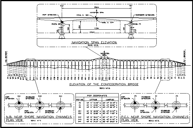
2.Confederation Bridge Diagram (see Annex)
3.The central navigation channel, is within the Confederation Bridge Compulsory Pilotage Area established in the General Pilotage Regulations (made under the Pilotage Act). Canadian vessels over 1,500 GT and foreign vessels, are subject to compulsory pilotage in the Confederation Bridge Compulsory Pilotage Area, in accordance with the General Pilotage Regulations.
4.Pilotage is mandatory on all Canadian vessels over 1500 GT and foreign vessels intending to transit under the bridge and are to use the “central navigation channel” and in the case of a tug and tow, a combination of the Gross Tonnage of the tug and tow is used.
5.No Vessel should transit under the Bridge in inclement weather or ice conditions as outlined in TP 13681 section 5.0 General guidelines for all vessels.
6.Vessels over 500 GT, solely propelled by sail, shall not transit under the Bridge.
7.Reports made pursuant to the Vessel Traffic Services Zones Regulations, vessels subject to the Vessel Traffic Services Zones Regulations must, when intending to proceed within 5 nautical miles of the Bridge, also report to Northumberland Traffic:
•ETA fairway buoy and confirm that Pilot has been
ordered and ETA to the Pilot Station when vessel is subject to
compulsory pilotage.
•Draft, displacement in tonnes, air draft and name of
local agent if not registered in Canada.
•When the vessel has a condition of
class, accident or a malfunction of its machinery,
equipment or a deficiency in its crewing that may impair its
safe navigation.
•Where an obstruction or other hazard is identified in
the central navigation channel or “near shore” navigation
channels.
•In the case of a towing vessel, where the towing vessel is having or anticipating difficulty in controlling its tow.
8.Towing vessels:
•Must not drop anchor or anchor its tows in such a
manner that they may swing across the central navigation
channel.
•Only one vessel or barge shall be towed under the
bridge per tug.
•Must not, when engaged in arranging its tow, obstruct
the navigation of other vessels.
•Must shorten its towing arrangement to the shortest
extent possible without compromising safety. When the towline
exceeds 75 metres a suitably sized tug should be secured to the
stern of the tow.
•Dead ship being towed are not permitted to transit under the Bridge,
9.Navigational Guidelines and Restrictions for Vessels over 1500GT transiting the “central navigation channel
•The navigation route for vessels over 1,500 GT transiting under the Bridge is through the central navigation channel.
•Maximum Displacement at Time of Transit
Passenger Vessel
: 34,000 Metric tonnes
Cargo Vessel: 47,700 Metric tonnes
Vessels exceeding the above maximum displacements need to submit a risk assessment that will include the use of an escort tug, as defined in TP 13681 section 3.0 Definitions.
If the vessel is 20% greater than the maximum displacement, then
2 such escort tugs need to be included in the
risk assessment.
The risk assessment should be submitted to the
Atlantic Regional Transport Canada Marine Safety and Security
OfficeFootnote1 and the Atlantic Pilotage Authority 15 business
days prior to transit.
•Maximum Speed
Passenger
vessels:11 knots over the ground within
2 nautical miles of the Bridge
Cargo
vessels: 8 knots over the ground
within 2 nautical miles of the Bridge
The speed of a vessel transiting may be increased when circumstances demand, and to keep the vessel on track. Speed limits are subject to enforcement actions.
•Maximum air draft (higher high water, large tides) - 48 meters
10.Navigation Guidelines for Vessels 1,500 GT and Under – Transiting the “Near Shore Navigation Channels”
•Local vessels 1,500 GT and under, that are engaged in local traffic, may utilize the designated “near shore” navigation channels located on either side of the Strait.
•The “near shore” navigation channels are designated between piers P3 and P4, P4 and P5, P42 and P43, P43 and P44. Piers are located as follows:
P3)46º 14’
33.29” N, 63º 42’ 53.76” W
P4)46º 14’
26.92” N, 63º 43’ 00.96” W
P5)46º 14’
20.54“ N, 63º 43’ 08.16” W
P42)46º 10’ 36.07” N, 63º 47’ 53.11” W
P43)46º 10’ 30.16” N, 63º 48’ 01.09” W
P44)46º 10’ 24.23” N, 63º 48’ 09.02” W
11.Restriction for vessels transiting the near shore channels:
•Maximum Speed over ground - 11 knots
•Maximum air draft (higher high water, large tides) - 28 meters
ANNEX
Report a problem on this page
- Date modified: