9AClosure to Crab Fishing: Deltaport and Tsawwassen Ferry Terminal
The Vancouver Fraser Port Authority (VFPA), doing business as Port of Vancouver, is an organization established and governed by the Canada Marine Act, as well as the Port Authorities Management Regulations and Letters Patent issued pursuant to the Act. VFPA is responsible for maintaining safe navigation in the waters within its jurisdiction.
The Department of Fisheries & Oceans (DFO) is the federal agency that delivers programs and services that support sustainable use and development of Canada’s waterways and aquatic resources. Section 24 of the Fisheries Act states that fishing apparatus “shall not be set or used in such manner or in such place as to obstruct […] navigation.”
VFPA and DFO have jointly determined that safety of navigation in the area described below under ‘Description of “Navigational Closure Area”’ requires closure to commercial crab fishing.
Purpose
The purpose of this closure is to maintain a safe approach for deep sea vessels, berthing tugs and ferries transiting in and out of Deltaport and Tsawwassen Ferry Terminal.
Fishing Gear: “Crab Floats & Traps”
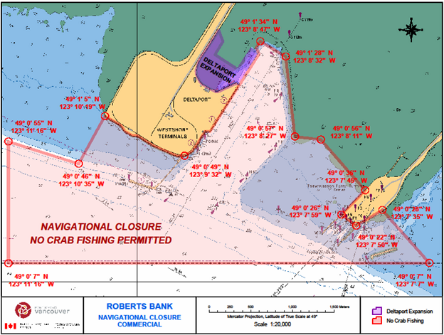
Crab floats and traps must remain at all times outside of the closure area described below and shown in the attached map. This area is reserved for navigation only. Any crab floats and traps placed in the closure area will be removed under the authority of VFPA/DFO. Crab fishers are reminded to consider the impact on navigation when placing gear outside the closure area.
Information on the “Navigational Closure Area” for Deltaport & Tsawwassen Ferry Terminal
Description of the “Navigational Closure Area”
The Navigational Closure Area includes the turning basin adjacent
to the container terminal, approaches to the Coal berth and
Tsawwassen Ferry Terminal as shown on the attached map* and
defined below. Coordinates are shown in chart datum
(NAD 83).
Restricted Area Coordinates: Starting from the in-shore end of turning basin
49° 01’ 34”N - 123° 08’ 47”W
49° 01’ 28”N - 123° 08’ 32”W
49° 00’ 57”N - 123° 08’ 27”W
49° 00’ 56”N - 123° 08’ 11”W
49° 00’ 36”N - 123° 07’ 46”W
49° 00’ 26”N - 123° 07’ 59”W
49° 00’ 22”N - 123° 07’ 50”W
49° 00’ 28”N - 123° 07’ 35”W
49° 00’ 07”N - 123° 07’ 07”W
49° 00’ 07”N - 123° 11’ 16”W
49° 00’ 55”N - 123° 11’ 16”W
49° 00’ 46”N - 123° 10’ 35”W
49° 01’ 05”N - 123° 10’ 19”W
49° 00’ 49”N - 123° 09’ 32”W, then following the shoreline of
Deltaport to the beginning point.
Contact List
In the case of a “Marine Emergency,” contact the Canadian Coast Guard radio on VHF 16, or for non-emergencies, contact the Marine Communications and Traffic Services at 250-363-6333.
For Navigational issues, contact VFPA’s Operations Center at 604-665-9086
For Fisheries issues and violations, contact the local office of Fisheries and Oceans Canada, the Steveston Field Office at 604-664-9250 during normal business hours or the DFO Observe Record Report (ORR) after-hours line at 1-800-465-4336.
For Boating Safety issues, contact Transport Canada, Office of Boating Safety at 250-480-2792.

Authority: Vancouver Fraser Port Authority
Report a problem on this page
- Date modified: