
7CVessels Intending to Navigate in Kitikmeot Region in Canada’s Northern Waters
Navigation In Kitikmeot Region
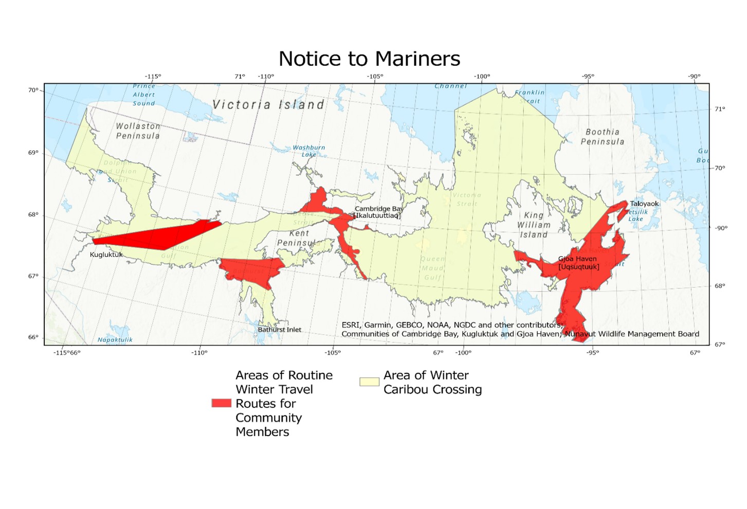
Dolphin and Union Caribou migrate between Victoria Island and the Mainland and King William Island areas. The open ice created by vessels jeopardizes the migration of the caribou in the fall and spring. Opened areas also present significant risks to the safety of people crossing the sea ice in the region.
Voluntary Avoidance
Voluntary measures apply to any vessel transiting within the protection zone outlined in this notice (see yellow and red areas in map above) and should only be taken when they will not jeopardize the safety of navigation. These include:
1.Slowdown to
minimum safe speed from December 1st to
June 30th (Red Areas);
2.Slowdown
to minimum safe speed if caribou or people are encountered;
3.Use local information to avoid passing in front of caribou or people traveling on sea ice as crossing routes may be subject to change;
4.Avoid opening multiple leads.
Reporting
Notice required a week prior and follow up call/emails before transiting the areas as follows. October 15th to November 30th and April 15th to June 30th to minimize risks to migrating caribou (Yellow Area), and December 1st to June 30th (Red Areas) to minimize risks to people traveling across sea ice. Preferred method of communication is via phone call.
Notice should be made, in order, to:
1.Gjoa Haven (Uqsuqtuuk)
a)Hamlet Office: 867-360-7141
b)Hunters and Trappers Organization Manager:
867-360-6028
2.Cambridge Bay (Ikalutuuttiaq)
a)Hamlet Main Office: 867-983-4600
b)Hamlet After Hours of Arctic Senior Administrative
Officer: 867-983-5203
c)Ekaluktutiak Hunters and Trappers Organization (EHTO)
Main Office: 867-983-2426
d)Ekaluktutiak Hunters and Trappers Organization (EHTO)
After Hours: 867-445-3614
e)Email: cambay@krwb.ca
3.Kugluktuk
a)Hamlet Office: 867-982-6500
b)Hunters and Trappers Organization Office: 867-982-4924
c)Email: kugluktuk@krwb.ca
Caribou Crossing Area Boundaries
Below are the coordinates points for reference. The area south of the northern coordinates can be referenced within the map.
|
Boundaries |
|
|
Western Boundary |
69° 95' N 117° 37' W 68° 96' N 117° 37' W |
|
Northern Boundary points (clockwise order) |
|
|
1.Victoria Island |
70° 21' N 101° 08' W |
|
2.North of Tingauyalik Island (Smaller island to Southwest) |
70° 40' N 100° 98' W |
|
3.North of Umingmalik Island (Gateshead Island) |
71° 02' N 101° 16' W |
|
4.Boothia Peninsula |
71° 43' N 099° 29' W |
Authority: Transport Canada
Report a problem on this page
- Date modified: