
7AVoyage Planning for Vessels Intending to Navigate in Canada’s Northern Waters
1Purpose
This notice is intended to assist mariners, owners and operators of vessels intending on navigating in Canada’s northern waters in preparing for, and executing, a safe voyage.
The recommendations and information provided in this notice are complementary to any other legal obligation of the owner, operator, master and all who have an interest in the vessel, and to the exercise of due diligence and good seamanship practices that are required from the master of a vessel.
2Background
The Canadian Arctic is full of challenges to maritime navigation due to its climatic conditions, low temperatures, hazardous and variable ice conditions, and geography. The region is remote and vast, making repairs, rescue, or clean-up operations difficult. Roads, airstrips, and ports are sparse, and search and rescue resources are limited. Emergencies can draw resources from other needed services such as icebreaking and community re-supply. In addition, the Canadian Arctic is environmentally sensitive and slow to recover from damage, so the impact of a pollution incident could have significant consequences. The mariner must also keep in mind that most of Canada’s Arctic waters have not been surveyed to modern standards.
Consequently, Arctic navigation requires vessel crews with specialized knowledge. A safe voyage starts with a detailed voyage plan that considers the Canadian Arctic’s unique conditions, navigational challenges, and hazards along with the vessel’s capabilities and operational limitations.
3Voyage Planning
International Maritime Organization (IMO) voyage planning guidelines and IMO's International Code for Ships Operating in Polar Waters (Polar Code) provisions must be considered when planning a voyage to Canadian Arctic waters. Chapter 11 refers to voyage planning and provides information on conducting a safe voyage.
The Navigation Safety Regulations, 2020 (NSR 2020) requires the master of a vessel before the vessel embarks on a voyage, to plan the voyage considering the Annex to IMO resolution A.893(21), Guidelines for Voyage Planning. If charts, documents, and publications are required to be kept on board under section 142 of NSR 2020, the master is to use those charts, documents, and publications to the extent that they relate to voyage planning.
Particularly relevant to Canadian Arctic navigation, the voyage plan shall, among other things, anticipate all known navigational hazards and adverse weather conditions and avoid, as far as possible, actions and activities that could cause damage to the environment. Passenger vessels should also consider IMO Resolution A.999 (25) Guidelines on Voyage Planning for Passenger Ships Operating in Remote Areas and Transport Canada’s Guidelines for the Operation of Passenger Vessels in Canadian Arctic Waters. (TP 13670)
In preparation for every Arctic voyage, the Master of the vessel must develop a comprehensive voyage plan. Given the unique risks associated with Arctic operations, the following factors should be considered, inter alia:
•Source, date, quality of hydrographic surveys,
Category Zone of Confidence (CATZOC) information and
data.
•Up-to-date charts of the appropriate scale, including
all relevant Notices to Mariners (NOTMARs) and radio
navigational warnings.
•Accuracy and availability of charting for the
intended route, particularly in infrequently used
areas.
•Contingency plans for emergencies where limited
Search and Rescue (SAR) support is available, including SAR
Cooperation Plans in accordance with SOLAS Regulation V/7.3
and
MSC.1/Circ.1184.
•Compliance with Chapter 11 of the Polar Code.
•Avoidance of navigation in uncharted or
insufficiently surveyed areas.
•Adequate Under Keel Clearance (UKC).
•Squat calculations and operational limitations.
•Bridge manning requirements.
•Identification of Places of Refuge.
•Position fixing methodology and intervals.
•Identification of No-Go Areas.
•Identification of Areas to be Avoided (ATBA).
Minimum Risk Mitigation Measures
•Transit in waters charted to modern standards, giving
due consideration to the quality and limitations of available
hydrographic data. Avoid transits through under-surveyed
areas where possible. Where transit through such areas is
necessary, conduct an appropriate risk assessment and ensure
suitable mitigation measures and contingency plans are in
place prior to transit.
•Reduce speed when required, including in the presence
of ice or limited visibility during hours of darkness.
•Maintain a safe distance from land.
•Continuously monitor ice and weather
conditions.
•Develop contingency routing for unforeseen wind, ice,
or sea state conditions.
•Request icebreaker escort services, as required.
•Post additional lookouts.
Additional Operational Guidance
•Carriage of additional navigational aids, in addition
to regulatory requirements, with suitably qualified crew to
operate and maintain them, such as forward-looking sonar.
Such equipment should be used only when appropriate and at
spectrum ranges of 200 kHz or above to minimize disturbance
to marine mammals.
•Subject to vessel and crew safety and availability,
the use of spotting craft or other methods to survey waters
ahead of passenger vessels, taking into consideration the
quality of available hydrographic data.
•Use of supernumerary navigational experts possessing local knowledge of the intended area of operations.
Mariners are advised to navigate with caution and remain fully
cognizant of the CATZOC information available through
Electronic Navigational Charts (ENCs) and displayed within
Electronic Chart Display and Information Systems (ECDIS).
The Zone of Confidence (ZOC) indicates the overall level of
confidence in the hydrographic data used to produce a chart
for a given area. CATZOC is the classification used on ENCs
to describe the quality and reliability of the underlying
survey data. Hydrographic Offices assess the quality of
hydrographic data and classify zones based on depth accuracy,
position accuracy, and seafloor coverage. Mariners should
consult their ECDIS operating manual to determine how to
access the quality of data information. CATZOC categories
(A1, A2, B, C, D, and U) range from high-quality, modern
surveys (A1) to very low or unassessed confidence (D or U).
Areas with lower ZOC or CATZOC ratings may contain
significant positional or depth uncertainties.
The CATZOC in ENCs should not be confused with Source
Classification diagrams, which can be found on Canadian
Hydrographic Service paper charts. The purpose of Source
Classification diagrams is to guide navigators and those
planning 'navigational operations' (including the planning of
new routes and official routeing measures) to the degree of
confidence they should have in the adequacy and accuracy of
charted depths and their positions. A Source diagram will
provide details of the survey from which each part of the
chart has been compiled, specifically with the age and survey
methodology of the data.
Regarding CATZOC, the following should be noted:
1.High accuracy depth information (ZOC A1 and A2),
shown as five stars or more.
2.Medium accuracy depth information (ZOC B), shown as
four stars.
3.Poor accuracy depth information (ZOC C, D and U), shown as three stars or less; or letter U.
Zones of Confidence (ZOC) Table
|
ZOC |
Position Accuracy |
Depth Accuracy |
Seafloor Coverage |
Typical Survey Characteristics |
|
|
A1 |
± 5m + 5% depth |
= 0.50 + 1%d |
Full area search undertaken. Significant seafloor features detected and depths measured. |
Controlled, systematic survey high position and depth accuracy achieved using DGPS or a minimum three high quality lines of position (LOP) and a multibeam, channel or mechanical sweep system. |
|
|
Depth (m) |
Accuracy (m) |
||||
|
10 |
± 0.6 |
||||
|
A2 |
± 20m |
= 1.00 + 2%d |
Full area search undertaken. Significant seafloor features detected and depths measured. |
Controlled, systematic survey achieving position and depth accuracy less than ZOC A1 and using a modern survey echosounder and a sonar or mechanical sweep system. |
|
|
Depth (m) |
Accuracy (m) |
||||
|
10 |
± 1.2 |
||||
|
B |
± 50m |
= 1.00 + 2%d |
Full search area not achieved; uncharted features, hazardous to surface navigation are not expected but may exist. |
Controlled, systematic survey achieving similar depth but lesser position accuracies than ZOC A2, using a modern survey echosounder, but no sonar or mechanical weep system. |
|
|
Depth (m) |
Accuracy (m) |
||||
|
10 |
± 1.2 |
||||
|
C |
± 500m |
= 2.00 + 5%d |
Full area search not achieved, depth anomalies may be expected. |
Low accuracy survey or data collected on an opportunity basis such as sounding on passage. |
|
|
Depth (m) |
Accuracy (m) |
||||
|
10 |
± 2.5 |
||||
|
D |
Worse than ZOC C |
Worse than ZOC C |
Full search not achieved, large depth anomalies expected. |
Poor quality data or data that cannot be quality assessed due to lack of information. |
|
|
U |
Unassessed – The quality of the bathymetric data has yet to be assessed. |
||||
Source: United Kingdom Hydrographic Office
The number of stars is an indication of the CATZOC value:
6 stars = A1 (in a triangle)
5 stars = A2 (in a triangle)
4 stars = B (in a triangle)
3 stars = C (in a horizontal bar)
2 stars = D (in a horizontal bar)
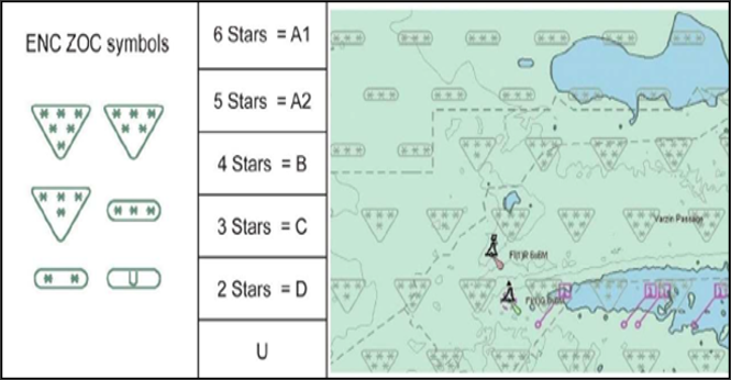
Source: International Hydrographic Office
Use of Navigational Information and Maintaining Adequate Safety Margins
Effective voyage planning in Arctic waters requires mariners to make full and informed use of all available navigational aids and reliable information sources. This includes, where available, consideration of ENC quality indicators such as the CATZOC. In addition, given the variability in the accuracy of hydrographic data across many Arctic areas, mariners should apply appropriate safety margins when assessing under-keel clearance, particularly when planning routes or deviating from an intended passage. Charted depths and features should not be relied upon in isolation; rather, they should be interpreted within the broader context of data quality, environmental conditions, and operational risk to support prudent, risk-based navigation.
Transport Canada has developed Guidelines for Assessing Ice Operational Risk (TP 15383). The information is intended for planning and operational purposes and is written for a diverse audience, including vessel designers, recognized organizations, vessel owners and operators, vessel management companies, communication and ice information agencies, the public at large and most importantly the bridge team. This publication can be ordered by contacting: marinesafety-securitemaritime@tc.gc.ca.
4Charts and Notices
At present, about 18.4% of Canadian Arctic waters are surveyed to modern standards. In addition, the mariner must be aware of the horizontal datum used for the chart. Global Navigation Satellite System (GNSS) positions can only be plotted directly on North American Datum 1983 (NAD 83) (equivalent to World Geodetic System 1984 (WGS 84)) charts. For charts with other datums, the appropriate correction must be applied. Some Arctic charts do not have a reference datum and therefore there are no corrections available for these charts. In such cases, alternative sources of positional information should be used such as radar and visual lines of position when possible. It is always recommended that more than one means is used to fix a position.
As always, mariners must use up-to-date nautical charts and nautical publications to plan each voyage. This includes making use of annual and monthly Notices to Mariners and Northern Canada Sailing Directions. Of note, given the challenges in charting Canada’s northern waters, confirming chart anomalies, and servicing aids to navigation, mariners must ensure that all Navigational Warnings (broadcast and written) and NAVAREA warnings that are in force in the area are considered. Further information can be obtained from the Canadian Coast Guard (CCG).
•For a list of charts and publications required
onboard the vessel, please refer to
NSR 2020, Part 1, Division 6. The master of a vessel must
ensure that the charts, documents and publications required
under this Division, before being used to plan and execute a
voyage, are correct and up-to-date, and based on information
that is contained in Notices to
Mariners or a Navigational
Warnings.
•Attention is also drawn to section 7 of the
Collision Regulations related to Notices to
Mariners and Navigational Warnings.
•The Arctic Regional Hydrographic Commission (ARHC) and the Arctic Council Working Group on the Protection of the Arctic Marine Environment (PAME) have officially released a joint advisory titled “Caution Required When Navigating in Arctic Waters”. This 2026 advisory serves as a critical update to the original cautionary note issued in the ARHC in 2017. The updated notes reflects significant shifts in the region, specifically addressing the challenges posed by a rapidly changing Arctic, the emergence of new maritime routes, and a steady increase in vessel traffic.
5Ice Advisory Service, Northern Vessel Traffic Services (Formerly NORDREG) Reporting, and Sail Plans
The CCG operates an ice advisory service to support vessels navigating in Canada’s northern waters during the navigation season. Vessels can obtain up-to-date information on ice conditions, advice on routes, aids to navigation and icebreaker support, when available and considered necessary, by contacting Northern Vessel Traffic Services (Formerly NORDREG). Weather, ice advisories, and forecasts are also broadcasted daily. Vessels subject to the Vessel Traffic Services Zones Regulations must report to Northen VTS as required by the regulations. Masters are reminded to promptly report all defects to Northern VTS when operating in the Canadian Arctic, as required by Vessel Traffic Services Regulations.
Vessels not required to report to Northern Vessel Traffic Services should, at a minimum, file a sail plan with a responsible person. This person should be instructed to call the Joint Rescue Coordination Centre if the vessel becomes overdue. In circumstances where it is not possible to file a sail plan with a responsible person, a sail plan may be filed by telephone, radio or in person, with a Marine Communications and Traffic Services (MCTS) Centre. While at sea, masters and operators who have filed a sail plan are encouraged to file a daily position report during long trips. After completion of the voyage, the vessel must close (or deactivate) their sail plan. Forgetting to do so can result in an unwarranted search.
All vessels to which Part 1 of the Arctic Shipping Safety and Pollution Prevention Regulations (ASSPPR) applies must report, as per section 9 of that regulation. More information on this topic can be found in section 8 of this notice.
The CCG publication Radio Aids to Marine Navigation should be consulted for further information including details on the Northern Vessel Traffic Services Zone, reporting, radio frequencies and times for ship/shore communications and broadcasts.
6Ice Navigation in Canadian Waters
The CCG publication, Ice Navigation in Canadian Waters indicates the necessary precautions to be taken by vessel navigating in Canadian ice-covered waters. The document provides masters and watch keeping officers with the necessary information to achieve an understanding of the hazards, navigation techniques, and response of the vessel. It includes information on passage planning for routes in ice-covered waters and principles of high latitude navigation. Every vessel of 100 gross tonnage, or over, navigating in Canadian waters in which ice may be encountered is required to carry and make use of this publication (NSR 2020).
7Contingency Planning
Two vessels groundings during the 2010 Canadian Arctic shipping season, one in 2018, and two in 2025 serve as a strong reminder of the critical importance of contingency planning and thorough risk assessment for Arctic operations.
As stated in the IMO Guidelines for Voyage Planning (A.893(21)), a detailed voyage plan should include, among other things, “contingency plans for alternative action to place the vessel in deep water or proceed to a port of refuge or safe anchorage in the event of any emergency necessitating abandonment of the plan, taking into account existing shore-based emergency response arrangements and equipment and the nature of the cargo and of the emergency itself.”
Access to emergency support services in Canadian Arctic waters is extremely limited, and there are currently no dedicated emergency response organizations operating in the Canadian North. Accordingly, it is highly recommended that shipowners pre-arrange emergency support prior to the voyage, including towing assistance, salvage support, and spill response capability.
Vessels are also reminded that CCG icebreakers are unavailable in the Canadian Arctic during the winter months, and this should be considered when assessing the minimum survival time. Accordingly, vessels should be equipped with adequate life-saving appliances, survival equipment, and thermal protection suitable for extended survival periods, and the same should be reflected in the Polar Ship Certificate and Record of Equipment, as well as the Polar Waters Operational Manual (PWOM).
8Arctic Waters Pollution Prevention Act and the Polar Code
Vessels intending to operate within Canadian Arctic waters are subject to certain unique requirements in addition to those common to vessels operating elsewhere in Canada. The nature of these additional requirements varies from one vessel to another and depends on, among other things, vessel type, vessel size, area of operation, or activity in which the vessel is engaged. The Arctic Waters Pollution Prevention Act (AWPPA) and its associated regulations establish these unique requirements. The primary objectives are to address:
•the unique hazards associated with polar
operations,
•the additional demands that polar operations place on
vessels, their systems, and operations (including
navigation), and
•the vulnerability of coastal Arctic communities and polar ecosystems to vessel operations.
The Polar Code entered into force on 1 January 2017 and was implemented in Canada with the ASSPPR and communicated out to mariners via SSB No.: 05/2018. The Polar Code is mandatory for vessels operating under the International Convention for the Safety of Life at Sea (SOLAS) and the International Convention for the Prevention of Pollution from Ships (MARPOL). It regulates the design, construction, equipment, operational, training, search and rescue and environmental protection matters relevant to vessels operating in polar waters.
Details of Canada’s requirements and additional guidance for vessels operating in its Arctic waters can be found on Transport Canada’s website and by contacting Transport Canada’s Prairie and Northern Region Marine Safety and Security office.
8.1Zone Dates, AIRSS, and POLARIS
Arctic waters under Canadian jurisdiction are divided into 16 zones. The Shipping Safety Control Zones Order prescribes these zones (SSCZ). Schedule 1 of the ASSPPR outlines earliest entry and the latest exit dates for each zone and for each category of vessel. The zones have been organized in such a way that zone 1 has historically had the most severe ice conditions, and zone 16 the least. Higher ice-strengthened vessels can operate for longer periods in higher severity zones.
For vessels intending to operate outside of the dates of this prescriptive system have the option of using either the Arctic Ice Regime Shipping System (AIRSS) or the Polar Operational Limit Assessment Risk Indexing System (POLARIS). Both AIRSS and POLARIS are methodologies for determining ice operational risk that considers a vessel’s ice class and the prevailing ice conditions observed from the vessel's bridge. Transport Canada recognizes that the use of either AIRSS or POLARIS by identical vessels in identical ice regimes could produce minor differences in operating outcomes depending upon which system is used. To help address certain situations where this variance could occur, the Regulations therefore require that all Polar Class vessels and/or all vessels built after January 1, 2017, must use POLARIS. For vessels build before this date that carry a Polar Ship Certificate, they should use the system stipulated on the certificate. All other vessels are afforded the option of using either AIRSS or POLARIS when operating outside the zone dates. These vessels are required to submit their AIRSS or POLARIS message upon their first point of entry into each SSCZ or modification of their voyage. See ASSPPR for application information.
The details on the AIRSS system are found in the TP12259 - Arctic Ice Regime Shipping System (AIRSS) Standard. For additional information on using the Zone Dates, AIRSS and POLARIS see Guidelines for Assessing Ice Operational Risk (TP 15383).
8.2Polar Ship Certificate and Polar Waters Operating Manual
Section 6 of the ASSPPR has the effect of making the safety-related Polar Code requirements applicable to certain vessels operating in polar waters. All vessels to which section 6 of the ASSPPR apply, intending to operate in polar waters, must have a valid Polar Ship Certificate (PSC) onboard. For Canadian vessels the PSC will generally be issued by a Recognized Organization (RO). These vessels will also need to carry a PWOM. The PWOM will provide the Owner, Operator, Master, and crew with sufficient information regarding the vessel's operational capabilities and limitations to support their decision-making process. All crew members need to know the procedures and equipment described in the PWOM relevant to their assigned duties.
Vessels are reminded to observe the operational limitations stated in the Polar Ship Certificate, including but not limited to:
•Maximum/Minimum operating draughts
•Temperature limitations
•Latitude limitations
•Permitted ice conditions
Operations outside these limits should not be undertaken.
8.3Pollution Prevention
The ASSPPR contains a range of safety and pollution prevention requirements that address the unique risks confronted by ships operating in Canada’s Arctic. The regulations incorporate certain requirements of the Polar Code, albeit with the addition of Canadian modifications, that help ensure that strict safety measures and discharge requirements of the Arctic Waters Pollution Prevention Act are maintained.
Except where otherwise indicated, the pollution prevention sections of the ASSPPR apply to all Canadian vessels operating in polar waters, and foreign vessels operating within the SSCZ (including fishing vessels, pleasure craft, and vessels without a mechanical means of propulsion).
9Certificate of Proficiency and Ice Navigators
Vessels operating in polar waters are required to be crewed by personnel adequately trained, qualified, and experienced for operating in polar conditions. For Canadian Arctic waters the requirements are outlined in the ASSPPR.
Personnel training and qualification requirements per the Arctic Shipping Safety and Pollution Prevention Regulations
|
|
Requirements based on ice conditions or Zone Dates** |
|||
|
Polar Code |
Outside Zone dates in row 14 of the schedule |
|||
|
Ice Free |
Open Waters |
Other Waters |
||
|
Passenger vessels certified to Chapter 1 of SOLAS |
|
Basic training for master, chief mate, and officers in charge of a navigational watch |
Advanced training for master and chief mate Basic training for officers in charge of a navigational watch |
|
|
Tankers 500 gross tonnage or more certified to Chapter 1 of SOLAS |
|
|
||
|
Other vessels 500 gross tonnage or more |
|
|
|
|
|
Vessels 300 gross tonnage or more (including fishing vessels and pleasure craft) * |
|
|
|
Advanced training for ships operating in polar waters Or Experience as outlined in section 10(2)(b)(i) of ASSPPR |
|
Vessels carrying, or towing/pushing a vessel carrying, pollutants or dangerous goods* |
|
|
|
|
|
Vessels towing/pushing another vessel with a combined tonnage of 500 or more* |
|
|
|
|
*Vessels not certified to Chapter 1 of SOLAS
**Chart is provided as a visual reference. Operators
should consult the ASSPPR and Polar Code for further
information specific to their vessel
1.Ice terminologies such as Ice Free and Open Waters, are defined in the Polar Code.
The following definitions are to be noted
•Open Water: A large area of freely
navigable water in which ice is present in concentrations
less than 1/10. No ice of land origin is present.
•Bergy Water: An area of freely
navigable water in which ice of land origin is present. Other
ice types may also be present, although the total
concentration of all other ice is less than 1/10.
•Ice Free: No ice present.
•Other Waters: Waters that are neither Ice-Free nor Open Water.
Operators are reminded that the Canadian Arctic is generally considered to be ‘Other Waters’.
2.Basic training and advanced training for ships operating in polar waters, as required by the ASSPPR and the Polar Code, is defined in Chapter V Regulation V/4 of the International Convention on Standards of Training, Certification and Watchkeeping for Seafarers (STCW).
3.Experience outlined in section 10(2)(b)(i) of the ASSPPR states that the Ice Navigator must:
•have served on a vessel in the capacity of master or person in charge of the deck watch for at least 50 days, of which 30 days must have been served in international Arctic waters while the vessel was in ice conditions that required the vessel to be assisted by an icebreaker or that required manoeuvres to avoid concentrations of ice that might have endangered the vessel.
4.All Ice Navigators on a vessel must have all the qualifications under the Canada Shipping Act, 2001 to act as a master or a person in charge of the deck watch.
Additional Information and
Coming Amendments
For additional training and certification requirements, see
Ship Safety Bulletin 20/2023, which explains how masters,
deck officers and any other crew members can meet
certification and familiarization training requirements for
those on certain ships operating in polar waters. While the
ASSPPR and the Polar Code require officers to have
certification for vessel operating in polar waters in
accordance with the STCW Convention, the requirements to
obtain this certification are being addressed in coming
amendments to the
Marine Personnel Regulations.
Having qualified persons or Ice Navigators on board does not absolve the master and officers of the navigational watch of their duties and obligations for the safety of the vessel and protection of the environment.
10Further Considerations
The following section outlines recommended measures to mitigate
the impact of shipping on traditional hunting and fishing,
environmentally sensitive areas, marine mammals, and caribou
migration in the Canadian Arctic. It is strongly recommended
that the vessel operator review these measures before
undertaking a voyage in the Canadian Arctic.
The master shall plan a route considering Chapter 11 of the
Polar Code and the following:
•Current information on relevant vessel's routing
systems, speed recommendations and vessel traffic services
relating to known areas with densities of marine mammals,
including seasonal migration areas.
•National protected areas along the route.
oSection A of Annual Notice to Mariners provides
information on Marine Mammals Guidelines and Marine Protected
Areas, including the Canadian Arctic and refers to general
regulatory requirements for all Oceans Act Marine Protected
Areas which should be reviewed regularly for updates.
oThere are regulatory requirements for vessels
operating in the Tuvaijuittuq Marine Protected Area.
oVoluntary measures are in place to minimize risks of
vessel collisions, and potential impacts of underwater noise
on beluga whales and bowhead whales in the two established
Marine Protected Areas (the Tarium Niryutait Marine Protected
Areas and the Anguniaqvia niqiqyuam Marine Protected Areas)
in Canada’s Western Arctic within the Inuvialuit Settlement
Region.
oVessels navigating in the Kitikmeot Region should
also refer to section A of Annual Notice to Mariners. Note
that there are measures in place for the protection of
hunters and trappers and migrating caribou.
•The vessel should consider maintaining an extra
lookout when transiting Canadian Arctic waters.
•It is recommended that vessels carry individuals with
local knowledge of the vessel’s area of operations.
•Vessels could be subjected to land use conformity and
impact assessment determinations in the Canadian Arctic.
Vessels should contact relevant territorial authorities with
details of their planned transit before undertaking a voyage
through the Canadian waters (ex: Nunavut Planning Commission
and Environmental Impact Screening Committee).
•When transiting through the Tallurutiup Imanga National Marine Conservation Area (TINMCA), Sarvarjuaq Marine Protected Area and Qikiqtait Marine Protected Area notwithstanding emergency situations, vessels must navigate with caution and remain at a safe and practicable distance from sensitive areas.
Tallurutiup Imanga National Marine Conservation Area
The Tallurutiup Imanga (TI) National Marine Conservation Area
(NMCA), located in Nunavut and encompassing Lancaster Sound and
adjacent Arctic waters, covers approximately 108,000 km² and
protects one of the most biologically productive marine
ecosystems in the Arctic. The area provides critical habitat
for narwhal, beluga, bowhead whales, walrus, polar bears,
seals, seabirds, and Arctic char, while also supporting Inuit
harvesting, travel, and cultural practices.
Below is a map showing the area of TINMCA.

Source: Parks Canada
Sarvarjuaq Marine Protected Area
The Sarvarjuaq Marine Protected Area (MPA) was established in March 2026 in northern Baffin Bay within the North Water Polynya region. The protected area covers approximately 73,700 km² and includes ecologically significant marine habitat supporting narwhal, beluga, walrus, seals, seabirds, and other Arctic marine species. The area was established under the Oceans Act through collaboration between the Government of Canada and the Qikiqtani Inuit Association to support the conservation of ecologically and culturally important marine ecosystems, while recognizing Inuit harvesting rights and stewardship responsibilities.
Qikiqtait Marine Protected Area
The Qikiqtait Marine Protected Area (MPA) is in Lancaster Sound and eastern Jones Sound in the High Arctic region of Nunavut. Established under the Oceans Act in March 2026, the protected area conserves approximately 13,700 km² of ecologically significant marine habitat that supports polar bear, walrus, seals, narwhal, seabirds, and Arctic char populations, as well as important migratory and feeding areas for marine mammals. The MPA was established through collaboration between the Government of Canada and Inuit partners, including the Qikiqtani Inuit Association, and supports Inuit-led conservation and stewardship objectives while recognizing existing Inuit harvesting rights and traditional use activities.
11References
Department of Justice Canada
•Arctic
Shipping Safety and Pollution Prevention
Regulations
•Arctic
Waters Pollution Prevention Act
•Canada
Shipping Act, 2001
•Collision
Regulations
•Marine
Personnel Regulations
•Navigation
Safety Regulations, 2020
•Shipping
Safety Control Zones Order
•Vessel
Traffic Services Zone Regulations
Transport Canada
•Prairie
and Northern Region
•Marine
Publications Abstracts
•How
to Meet the STCW Requirements for Masters, Deck Officers and
Other Crew Members of Certain Canadian Ships Operating in
Polar Waters (Ship Safety Bulletin No. 20/2023)
•Coming
into force: New Arctic Shipping Safety and Pollution
Prevention Regulations - SSB No.: 05/2018
•TP
12259 Arctic Ice Regime Shipping System (AIRSS)
Standard
•TP
13670 Guidelines for the Operation of Passenger Vessels in
Canadian Arctic Waters
•TP 15383 Guidelines for Assessing Ice Operational Risk
Canadian Coast Guard
•Ice Navigation in Canadian Waters
•Marine
Communications and Traffic Services – Contacts
•Navigational
Warnings (NAVWARN)
•Notices to Mariners
(NOTMAR)
•Navigational
Areas (NAVAREAs)
•Radio Aids to Marine Navigation
Fisheries and Oceans Canada
•Northern Canada Sailing Directions
PAME:
•Protection of the Arctic Marine Environment
•Polar Water Operational Manual (PWOM)
IMO Resolutions
•A.893(21) Guidelines for Voyage Planning
•A.999(25) Guidelines on Voyage Planning for Passenger Ships
Authority: Transport Canada
Report a problem on this page
- Date modified: