
Archived information
The Standard on Web Usability replaces this content. This content is archived because Common Look and Feel 2.0 Standards have been rescinded.
Archived information is provided for reference, research or recordkeeping purposes. It is not subject to the Government of Canada Web Standards and has not been altered or updated since it was archived.
|
|
Fisheries and Oceans Canada |
Pêches et Ocèans Canada |
|
 |
|||
| MONTHLY EDITION N°10 October 31th, 2014 |
|||
|
CONTENTS |
|||
Page |
|||
| Section 1 |
Safety and General Information | 1 - 4 |
|
| Section 2 |
Chart Corrections | 5 - 11 |
|
| Section 3 |
Radio Aids to Marine Navigation Corrections | 12 - 13 |
|
| Section 4 |
Sailing Directions and Small Craft Guide Corrections | 14 |
|
| Section 5 |
List of Lights, Buoys and Fog signals Corrections | N/A |
|
Maritime Services Directorate Aids to Navigation |
|||
Fisheries and Oceans Canada - Official publication of the Canadian Coast Guard |
|||

Geographical positions refer directly to the graduations of the largest scale Canadian Hydrographic chart unless otherwise indicated.
Bearings refer to the true compass and are measured clockwise from 000° (North) clockwise to 359°; those relating to lights are from seaward.
Visibility of lights is that in clear weather.
Depths - The units used for soundings (metres, fathoms or feet) are stated in the title of each chart.
Elevations are normally given above Higher High Water, Large Tides unless otherwise indicated.
Distances may be calculated as follows:
1 nautical mile = 1 852 metres (6,076.1 feet)
1 statute mile = 1 609.3 metres (5,280 feet)
1 metre = 3.28 feet
Temporary & Preliminary Notices are indicated by a (T) or a (P) before the chart action and in the section 1. Please note that Nautical charts are not amended by the Canadian Hydrographic Service for Temporary (T) and Preliminary (P) Notices. It is recommended that mariners chart these corrections in pencil. Listing of charts affected by Temporary and Preliminary Notices are revised and promulgated quarterly in Section 1 of the Monthly Edition.
Please note that, in addition to the temporary and preliminary changes normally advertised as (T) and (P) Notices, there are a few permanent changes to navigational aids that have been advertised as Preliminary Notices to Mariners while charts are being updated for new editions.
Marine Information Report & Suggestion Sheet - Mariners are requested to notify the responsible authorities when new or suspected dangers to navigation are discovered, changes observed in aids to navigation or corrections to publications are seen to be necessary. Such communications can be made using the Marine Information Report & Suggestion Sheet inserted on the last page of each monthly edition of Notices to Mariners.
Canadian Hydrographic Service - Information Published in Section 2 Notices to Mariners - Mariners are advised that only the most critical changes that directly affect safety to navigation are issued in Chart Corrections - Section 2. This limitation is required to ensure that charts remain as clear and easy to read as possible. As a result, mariners may see minor discrepancies of a non-critical nature between information in official publications. For example, a small change in the nominal range or height of a light may not result in the production of a chart correction, in Notices to Mariners, but may result in a List of Light, Buoys and Fog Signals correction.
In case of discrepancy between information provided on CHS charts related to aids to navigation, and the List of Light publication, the latter shall be deemed as containing the most up to date information
Canadian Nautical Charts & Publications - A source list of Canadian Nautical Charts & Publications is
published in Notice No. 14 of the Notices to Mariners Annual Edition April 2011. The source supply and the prices
effective at the time of printing are listed. For current chart edition dates refer to the following web site:
http://www.chs-shc.gc.ca/charts-cartes/paper-papier/index-eng.asp
NOTE: Cette publication est aussi disponible en français.
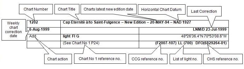
Corrections to nautical charts will be listed in numeric order by chart number. Each chart correction listed applies only to that particular chart. Related charts, if any, will have their own specific correction listed separately.
Users should also refer to CHS Chart 1 Symbols, Abbreviations Terms for additional information pertaining to the correction of charts.
The illustration below describes the elements that will comprise a typical Section 2 chart correction.
MONTHLY EDITION OF NOTICES TO MARINERS
WEB ACCESS
We are offering a feature where subscribers to our on-line service are able to receive the complete electronic monthly edition of
our Notices to Mariners. We are encouraging our clients to visit the web site to subscribe for this service:
http://www.notmar.gc.ca/subscribe/
Users wishing to receive information updates for their charts can do so by setting up a ’User Profile’ on the following web page http://www.notmar.gc.ca/search/mycharts-eng.php?czoxOToibnRtPXN0ZXBfb25lJmxhbmc9ZSI7
This feature permits users to register the nautical charts they currently have in their possession. Registrants are then automatically notified by e-mail when a Notice to Mariners is published concerning these charts.
ADVISORY
NOTICES TO SHIPPING (WRITTEN AND BROADCAST)
The Canadian Coast Guard is implementing a number of changes to the aids to navigation system in Canada.
These changes are advertised as Notices to Shipping (Broadcast and Written) by the Canadian Coast Guard and are followed up with Notices to Mariners, then charts are updated by hand correction, reprints or new editions.
Mariners are advised that all relevant Written Notices to Shipping should be kept until superseded by Notices to Mariners or through revised charts issued by the Canadian Hydrographic Service.
Written Notices to Shipping are available on the Canadian Coast Guard Website at: www.ccg-gcc.gc.ca/eng/CCG/NOTSHIP.
The Canadian Hydrographic Service is reviewing the impact of these changes with the Canadian Coast Guard and together we are preparing an action plan on the issuing of chart revisions.
For further information contact your local Regional Notices to Shipping (NOTSHIP) issuing authorities.
Pacific Telephone: (604) 666-6011 RMIC Email: rmic-pacific@pac.dfo-mpo.gc.ca |
* Fisheries and Oceans Canada Telephone: (867) 979-5269 Email: IQANORDREG@INNAV.GC.CA |
* Services provided in English and French
INDEX
CANADIAN HYDROGRAPHIC SERVICE - ANNOUNCEMENT REGARDING CANADIAN HYDROGRAPHIC SERVICE CHART PATCHES. |
1 |
CANADIAN HYDROGRAPHIC SERVICE - CUMULATIVE CHART CORRECTIONS. |
1 |
CANADIAN HYDROGRAPHIC SERVICE - CURRENT CHART EDITION DATES. |
1 |
CANADIAN HYDROGRAPHIC SERVICE - PRINT ON DEMAND CHARTS - CARE AND USE. |
1 |
CANADIAN HYDROGRAPHIC SERVICE - TRANSPORT CANADA NAVIGATION SAFETY - ECDIS. |
2 |
CONSOLIDATION OF MARINE COMMUNICATIONS AND TRAFFIC SERVICES (MCTS) CENTRES. |
2 |
*1002 CANADIAN HYDROGRAPHIC SERVICE - NAUTICAL CHARTS |
2 |
*1003 CANADIAN HYDROGRAPHIC SERVICE - ELECTRONIC NAVIGATIONAL CHARTS |
2 |
*1017 CANADIAN COAST GUARD - LIST OF CHARTS AND REFERENCE CHARTS (SECTION I) AFFECTED BY TEMPORARY AND PRELIMINARY NOTICES |
3 |
*1018 GREAT SLAVE LAKE / GRAND LAC DES ESCLAVES, WESTERN PORTION / PARTIE OUST – BUOYS DISCONTINUED. |
4 |
*1019 RADIO AIDS TO MARINE NAVIGATION 2014, PACIFIC AND ARCTIC. |
12 |
| NUMERICAL INDEX OF CANADIAN CHARTS AFFECTED | |||||
| Chart No. | Page | Chart No. | Page | Chart No. | Page |
| 3002 | 5 | 3726 | 6, 7 | 3939 | 10, 11 |
| 3313 | 5 | 3737 | 7 | 3986 | 11 |
| 3440 | 5 | 3744 | 7, 8 | 4641 | 4 |
| 3461 | 5 | 3800 | 8, 9 | 5351 | 2 |
| 3462 | 5 | 3902 | 9 | 7181 | 2 |
| 3724 | 6 | 3938 | 9, 10 | ||
CANADIAN HYDROGRAPHIC SERVICE - ANNOUNCEMENT REGARDING CANADIAN HYDROGRAPHIC SERVICE CHART PATCHES.
Colour Web Patches are free to the mariner, and given the quality of many printers, should reproduce well. They will be available in real time all around the world.
CHS welcomes your feedback on this service at chsinfo@dfo-mpo.gc.ca
CANADIAN HYDROGRAPHIC SERVICE - CUMULATIVE CHART CORRECTIONS.
The cumulative Notices to Mariners corrections for charts can now be accessed at
www.notmar.gc.ca/search/notmar-eng.php
CANADIAN HYDROGRAPHIC SERVICE - Current chart edition dates.
CHART EDITIONS
The three terms described below are used to indicate the publication status of Canadian charts.
NEW CHART - "NEWCHT"
The first publication of a Canadian chart embracing an area not previously charted to the scale shown, or embracing an area different from any existing Canadian chart.
NEW EDITION - "NEWEDT"
A new issue of an existing chart containing amendments essential to navigation in addition to those issued in Notices to Mariners and making existing editions obsolete.
REPRINTS
A new issue of the current edition of a chart incorporating no amendments of navigational significance other than those previously promulgated in Notices to Mariners. It may also contain amendments from other sources provided they are not essential to navigation. Previous printings of the current edition remain in force
The current chart edition dates can be accessed at www.chs-shc.gc.ca/charts-cartes/paper-papier/index-eng.asp
CANADIAN HYDROGRAPHIC SERVICE - PRINT ON DEMAND CHARTS - CARE AND USE.
Background
By providing nautical charts to the public, the goal of the Canadian Hydrographic Service (CHS) is to provide services for safe navigation in a fiscally responsible manner. As a result, CHS continues to expand its portfolio of nautical paper charts that are printed using Print On Demand (POD) technology. These charts are easily recognized by their whiter paper and the coloured logo of the Canadian Hydrographic Service. This new technology enables CHS to print charts in a more efficient manner while enhancing chart content through being able to quickly add new and important information. POD technology provides customers with up-to-date charts without the historical hand-drawn corrections or glued-on patches. Additionally, this technology eliminates out-of-stock situations which arise with the traditional printing and warehousing methods. In the event of a national emergency, CHS can respond to the appropriate authorities with best available information very quickly.
Care of Your POD Chart
CHS encourages its customers to handle the POD charts more carefully than the traditional lithographic charts. When plotting information on POD charts, use HB pencils and apply limited pressure. Testing has suggested that an Indian gum eraser is more effective than alternatives when used on the product. This eraser is also suitable for charts printed using lithographic processes.
CANADIAN HYDROGRAPHIC SERVICE - TRANSPORT CANADA NAVIGATION SAFETY - ECDIS.
Mariners are advised that ECDIS may not display some isolated shoal depths when operating in "base or standard display" mode. Route planning and monitoring alarms for these shoal depths may not always be activated. To ensure safe navigation and to confirm that a planned route is clear of such dangers, mariners should visually inspect the planned route and any deviations from it using ECDIS configured to display "all data". The automated voyage planning check function should not be solely relied upon.
Consolidation of Marine Communications and Traffic Services (MCTS) Centres.
The Canadian Coast Guard is consolidating and modernizing its Marine Communications and Traffic Services. These changes will result in a configuration of 12 MCTS Centres strategically located across the country. Information pertaining to consolidation will be advertised to clients by all available means.
Western Region
Tofino MCTS will close; services will be provided remotely by Prince Rupert MCTS
Comox and Vancouver MCTS will close; services will be provided remotely by Victoria MCTS
There will be no reduction in the MCTS level of service provided to clients. Mariners should be aware that, as a result of consolidation, contact information, weather and other pertinent marine broadcast schedules may change. These changes will be advertised in RAMN, as they become available.
Mariners should check NOTMAR PART 3 on a monthly basis for updates.
*1002 CANADIAN HYDROGRAPHIC SERVICE - NAUTICAL CHARTS.
| CHARTS | MAIN TITLE | SCALE | PUBLISHED | CAT# | PRICE |
| New Editions | |||||
| 5351 | Payne Bay and Approaches | 1:50000 | 27-JUN-2014 | 4 | 20.00 |
| 7181 | Durban Harbor | 1:12500 | 08-AUG-2014 | 4 | 20.00 |
*1003 CANADIAN HYDROGRAPHIC SERVICE - ELECTRONIC NAVIGATIONAL CHARTS.
| NEW PRODUCTS | |
| S-57 ENC NUMBER | CHART TITLE |
| CA376336 | Bonavista Bay, Western Portion/Partie ouest |
| CA376337 | Continuation A |
| CA476479 | Bay D'Espoir and/et Hermitage Bay |
| CA476480 | Hermitage Bay, Continuation |
| CA573440 | Meldrum Bay |
| CA576291 | St. Peters Bay |
| CA576292 | St. Peters Canal |
| CA576373 | Greenspond Harbour to/à Pond Cove |
| CA576374 | Valleyfield |
| CA576375 | Wesleyville |
| CA576481 | Gaultois Harbour |
| CA576482 | Hermitage Harbour |
| CA576484 | McCallum |
| WITHDRAWN PRODUCTS | |
| CA470325 | Cousins Inlet - Continuation A |
*1017 CANADIAN COAST GUARD - LIST OF CHARTS AND REFERENCE CHARTS (SECTION I) AFFECTED BY TEMPORARY AND PRELIMINARY NOTICES
IN EFFECT SEPTEMBER 26, 2014
(REVISED AND PROMULGATED QUARTERLY)
| 2017 | 909(P)14 |
| 2305 | 1204(P)/08 |
| 3546 | 714(P)/14 |
| 4010 | 605(P)/14 |
| 4124 | 307(P)/14 |
| 4130 | 604(P)/14 |
| 4201 | 509(P)/13 |
| 4233 | 210(P)/12 |
| 4241 | 810(P)/14 |
| 4243 | 308(P)/14 |
| 4266 | 420(P)/14 |
| 4279 | 1210(P)/13 |
| 4281 | 1111(P)/11 |
| 4340 | 305(P)/14; 306(P)/14, 418(P)/14 |
| 4367 | 508(P)/14; 704(P)/14 |
| 4377 | 405(P)/13 |
| 4386 | 1108(P)/13, 507(P)/14 |
| 4396 | 510(P)/13; 705(P)/14; 706(P)/14; 709(P)/14; 710(P)/14; 711(P)/14 |
| 4406 | 708(P)/14 |
| 4449 | 1211(P)/13; 106(P)/14 |
| 4450 | 1005(P)/13; 1006(P)/13 |
| 4466 | 109(P)/14 |
| 4512 | 1205(P) /13 |
| 4522 | 1103(T) /13; 1207(T) /13; |
| 4530 | 811(P)/14 |
| 4596 | 1209(T) /13; |
| 4641 | 906(P)/14; 907(P)/14; 908(P)/14 |
| 4670 | 1206(T) /13; |
| 4679 | 603(P)/14 |
| 4830 | 1104(T) /13; |
| 4857 | 812(P)/14 |
| 4905 | 204(P) /14 |
| 4909 | 613(P)/12, 810(P)/12; 205(P) /14; 206 (P) /14; 207(P) /14; 304(P) /14, 421(P)/14 |
| 4911 | 811(P)/12, 612(P)/13 |
| 4921 | 713(P)/13 |
| 5051 | 1208(T) /13; |
| 6267 | 112(P)/06 |
| US14832 | 712(P)/14 |
| US14884 | 715(T)/13 |
1018 GREAT SLAVE LAKE / GRAND LAC DES ESCLAVES, WESTERN PORTION / PARTIE OUST – BUOYS DISCONTINUED.
Reference chart: 4641
The following buoys have been discontinued:
Red conical buoy Res Delta # 6 GP1-01 in 61°21' 49".2N 113° 37' 22".8W
Green can buoy Res Delta #7 in 61°22' 06".2N 113° 39' 31".2W
Green can buoy Res Delta #9 in 61°22' 15".6N 113° 28' 45"W
Green can buoy Res Delta #11 in 61°21' 56".4N 113° 37' 11".4W
Green can buoy Res Delta #13 in 61°21' 35".4N 113° 36' 45".6W
(A2014-18; 19; 20; 21; 22)
CHART CORRECTIONS
| 3002 - Queen Charlotte Sound to/à Dixon Entrance - New Edition - 16-DEC-1994 - NAD 1927 | |||
| 24-OCT-2014 | LNM/D. 10-OCT-2014 | ||
| Delete | depth of 9 fathoms (See Chart No. 1, I10) |
52°35′35.0″N 129°18′39.0″W | |
| DFO(6202911-15) | |||
| Add | depth of 6 fathoms 5 feet (See Chart No. 1, I10) |
52°35′27.5″N 129°18′40.5″W | |
| DFO(6202911-16) | |||
| Delete | depth of 15 fathoms (See Chart No. 1, I10) |
52°33′34.0″N 129°19′20.0″W | |
| DFO(6202911-17) | |||
| Add | depth of 12 fathoms (See Chart No. 1, I10) |
52°33′28.5″N 129°19′25.5″W | |
| DFO(6202911-18) | |||
| 10-OCT-2014 | LNM/D. 13-JUN-2014 | ||
| Add | depth of 3 fathoms 5 feet (See Chart No. 1, I10) |
52°27′35.0″N 129°15′53.0″W | |
| DFO(6202906-01) | |||
| Delete | depth of 21 fathoms (See Chart No. 1, I10) |
52°27′50.0″N 129°16′00.0″W | |
| DFO(6202906-02) | |||
| 3313 - Haro Strait South/Sud - Sheet/Feuille 22 - New Edition - 02-JAN-2009 - NAD 1983 | |||
| 03-OCT-2014 | LNM/D. 15-AUG-2014 | ||
| Add | depth of 1.5 metres (See Chart No. 1, I10) This notice affects Electronic Navigational Chart: CA370367 |
48°27′53.5″N 123°02′58.5″W | |
| DFO(6202905-01) | |||
| 3440 - Race Rocks to/à D'Arcy Island - New Edition - 01-JUL-2005 - NAD 1983 | |||
| 03-OCT-2014 | LNM/D. 12-SEP-2014 | ||
| Add | depth of 1.5 metres (See Chart No. 1, I10) This notice affects Electronic Navigational Chart: CA370367 |
48°27′53.5″N 123°02′58.5″W | |
| DFO(6202905-01) | |||
| 3461 - Juan de Fuca Strait, Eastern Portion/Partie Est - New Edition - 01-JUL-2005 - NAD 1983 | |||
| 03-OCT-2014 | LNM/D. 12-SEP-2014 | ||
| Add | depth of 1.5 metres (See Chart No. 1, I10) This notice affects Electronic Navigational Chart: CA370367 |
48°27′53.5″N 123°02′58.5″W | |
| DFO(6202905-01) | |||
| 3462 - Juan de Fuca Strait to/à Strait of Georgia - New Edition - 01-JUL-2005 - NAD 1983 | |||
| 03-OCT-2014 | LNM/D. 12-SEP-2014 | ||
| Add | depth of 1.5 metres (See Chart No. 1, I10) This notice affects Electronic Navigational Chart: CA370367 |
48°27′53.5″N 123°02′58.5″W | |
| DFO(6202905-01) | |||
| 3724 - Caamaño Sound and Approaches/et les approches - New Edition - 23-MAY-1980 - Inconnu | |||
| 24-OCT-2014 | LNM/D. 03-OCT-2014 | ||
| Add | depth of 3 fathoms (See Chart No. 1, I10) |
52°39′31.0″N 129°25′31.0″W | |
| DFO(6202911-12) | |||
| Add | depth of 1 fathom (See Chart No. 1, I10) |
52°39′45.5″N 129°25′27.0″W | |
| DFO(6202911-13) | |||
| Add | depth of 10 fathoms (See Chart No. 1, I10) |
52°42′22.0″N 129°25′49.0″W | |
| DFO(6202911-14) | |||
| 03-OCT-2014 | LNM/D. 26-SEPT-2014 | ||
| Add | depth of ½ fathom (See Chart No. 1, I10) |
53°01′43.5″N 129°43′06.5″W | |
| DFO(6202904-01) | |||
| 3726 - Laredo Sound and Approaches - New Edition - 23-MAY-1980 - Inconnu | |||
| 24-OCT-2014 | LNM/D. 26-SEP-2014 | ||
| Delete | depth of 9 fathoms (See Chart No. 1, I10) |
52°35′35.0″N 129°18′39.0″W | |
| DFO(6202911-01) | |||
| Add | depth of 6¾ fathoms (See Chart No. 1, I10) |
52°35′30.0″N 129°18′38.0″W | |
| DFO(6202911-02) | |||
| Delete | depth of 43 fathoms (See Chart No. 1, I10) |
52°35′21.0″N 129°19′36.0″W | |
| DFO(6202911-03) | |||
| Add | depth of 15 fathoms (See Chart No. 1, I10) |
52°35′20.0″N 129°19′32.5″W | |
| DFO(6202911-04) | |||
| Delete | depth of 15 fathoms (See Chart No. 1, I10) |
52°33′34.0″N 129°19′20.0″W | |
| DFO(6202911-05) | |||
| Add | depth of 12 fathoms (See Chart No. 1, I10) |
52°33′31.0″N 129°19′23.0″W | |
| DFO(6202911-06) | |||
| Delete | depth of 49 fathoms (See Chart No. 1, I10) |
52°33′09.0″N 129°18′20.0″W | |
| DFO(6202911-07) | |||
| Add | depth of 13 fathoms (See Chart No. 1, I10) |
52°33′10.0″N 129°18′29.0″W | |
| DFO(6202911-08) | |||
| Add | depth of 3 fathoms (See Chart No. 1, I10) |
52°38′38.5″N 129°25′31.0″W | |
| DFO(6202911-09) | |||
| Add | depth of 3 fathoms (See Chart No. 1, I10) |
52°39′31.0″N 129°25′37.0″W | |
| DFO(6202911-10) | |||
| Add | depth of 1 fathom (See Chart No. 1, I10) |
52°39′46.0″N 129°25′33.0″W | |
| DFO(6202911-11) | |||
| 3737 - Laredo Channel including/y compris Laredo Inlet and/et Surf Inlet - New Edition - 14-AUG-1987 - Inconnu | |||
| 24-OCT-2014 | LNM/D. 22-AUG-2014 | ||
| Delete | depth of 9 fathoms (See Chart No. 1, I10) |
52°35′32.0″N 129°18′38.0″W | |
| DFO(6202911-23) | |||
| Add | depth of 6¾ fathoms (See Chart No. 1, I10) |
52°35′29.5″N 129°18′36.0″W | |
| DFO(6202911-24) | |||
| Delete | depth of 43 fathoms (See Chart No. 1, I10) |
52°35′21.0″N 129°19′36.0″W | |
| DFO(6202911-25) | |||
| Add | depth of 15 fathoms (See Chart No. 1, I10) |
52°35′19.5″N 129°19′30.5″W | |
| DFO(6202911-26) | |||
| Delete | depth of 15 fathoms (See Chart No. 1, I10) |
52°33′33.0″N 129°19′24.0″W | |
| DFO(6202911-27) | |||
| Add | depth of 12 fathoms (See Chart No. 1, I10) |
52°33′30.0″N 129°19′21.0″W | |
| DFO(6202911-28) | |||
| Delete | depth of 49 fathoms (See Chart No. 1, I10) |
52°33′09.0″N 129°18′24.0″W | |
| DFO(6202911-29) | |||
| Add | depth of 13 fathoms (See Chart No. 1, I10) |
52°33′09.5″N 129°18′27.0″W | |
| DFO(6202911-30) | |||
| 3744 - Queen Charlotte Sound - New Edition - 20-MAY-1988 - NAD 1927 | |||
| 24-OCT-2014 | LNM/D. 22-AUG-2014 | ||
| Delete | depth of 9 fathoms (See Chart No. 1, I10) This notice affects Electronic Navigational Chart: CA270724 |
52°35′30.0″N 129°18′42.0″W | |
| DFO(6202911-19) | |||
| Add | depth of 6 fathoms 5 feet (See Chart No. 1, I10) This notice affects Electronic Navigational Chart: CA270724 |
52°35′28.5″N 129°18′34.5″W | |
| DFO(6202911-20) | |||
| Delete | depth of 15 fathoms (See Chart No. 1, I10) This notice affects Electronic Navigational Chart: CA270724 |
52°33′30.0″N 129°19′33.0″W | |
| DFO(6202911-21) | |||
| Add | depth of 12 fathoms (See Chart No. 1, I10) This notice affects Electronic Navigational Chart: CA270724 |
52°33′29.0″N 129°19′19.5″W | |
| DFO(6202911-22) | |||
| 3800 - Dixon Entrance - New Chart - 06-MAY-2011 - NAD 1983 | |||
| 10-OCT-2014 | LNM/D. 13-JUN-2014 | ||
| Add | international maritime boundary (See Chart No. 1, N41) This notice affects Electronic Navigational Chart: CA37019 |
joining 54°39′44.0″N 132°41′03.1″W 54°40′11.3″N 132°25′33.2″W 54°40′36.6″N 132°10′03.0″W 54°41′00.0″N 131°54′32.5″W 54°41′21.3″N 131°39′01.7″W 54°41′40.7″N 131°23′30.7″W 54°41′58.1″N 131°07′59.4″W 54°42′13.5″N 130°52′27.9″W and 54°42′21.7″N 130°43′09.2″W |
|
| DFO(6202907-01) | |||
| Add | radio reporting line (See Chart No. 1 M40.2) This notice affects Electronic Navigational Chart: CA370191 |
joining 54°39′44.0″N 132°41′03.1″W 54°40′11.3″N 132°25′33.2″W 54°40′36.6″N 132°10′03.0″W 54°41′00.0″N 131°54′32.5″W 54°41′21.3″N 131°39′01.7″W 54°41′40.7″N 131°23′30.7″W 54°41′58.1″N 131°07′59.4″W 54°42′13.5″N 130°52′27.9″W and 54°42′21.7″N 130°43′09.2″W |
|
| DFO(6202907-02) | |||
| Reposition | calling-in point 23 with arrowhead pointing 0° and 180° (See Chart No. 1, M40.1) |
from 54°41′00.0″N 131°44′54.0″W to 54°41′14.0″N 131°44′54.0″W |
|
| DFO(6202907-03) | |||
| Reposition | note See / Voir note VTS ZONE / ZONE STM |
from 54°41′26.0″N 131°24′34.0″W to 54°41′42.0″N 131°23′01.0″W |
|
| DFO(6202907-04) | |||
| Reposition | note USA / É-UA CANADA |
from 54°41′46.0″N 131°08′45.0″W to 54°41′58.0″N 131°08′48.0″W |
|
| DFO(6202907-05) | |||
| Delete | international maritime boundary (See Chart No. 1, N41) |
between 54°39′48.0″N 132°41′33.0″W and 54°42′20.0″N 130°43′09.0″W |
|
| DFO(6202907-06) | |||
| Delete | radio reporting line (See Chart No. 1, M40.2) |
between 54°39′45.0″N 132°41′02.0″W and 54°42′20.0″N 130°43′09.0″W |
|
| DFO(6202907-07) | |||
| 3902 - Hecate Strait - New Edition - 09-DEC-1988 - NAD 1927 | |||
| 24-OCT-2014 | LNM/D. 22-AUG-2014 | ||
| Delete | depth of 9 fathoms (See Chart No. 1, I10) This notice affects Electronic Navigational Chart: CA270724 |
52°35′30.0″N 129°18′42.0″W | |
| DFO(6202911-19) | |||
| Add | depth of 6 fathoms 5 feet (See Chart No. 1, I10) This notice affects Electronic Navigational Chart: CA270724 |
52°35′28.5″N 129°18′34.5″W | |
| DFO(6202911-20) | |||
| Delete | depth of 15 fathoms (See Chart No. 1, I10) This notice affects Electronic Navigational Chart: CA270724 |
52°33′30.0″N 129°19′33.0″W | |
| DFO(6202911-21) | |||
| Add | depth of 12 fathoms (See Chart No. 1, I10) This notice affects Electronic Navigational Chart: CA270724 |
52°33′29.0″N 129°19′19.5″W | |
| DFO(6202911-22) | |||
| 3938 - Queens Sound to/à Seaforth Channel - New Chart - 02-APR-2004 - NAD 1983 | |||
| 10-OCT-2014 | LNM/D. 26-OCT-2012 | ||
| Add | depth of 5.4 metres (See Chart No. 1, I10) This notice affects Electronic Navigational Chart: CA470324 |
52°10′22.0″N 128°05′49.5″W | |
| DFO(6202908-01) | |||
| Add | depth of 5.3 metres (See Chart No. 1, I10) This notice affects Electronic Navigational Chart: CA470324 |
52°09′38.5″N 128°07′01.0″W | |
| DFO(6202908-02) | |||
| Delete | depth of 6.5 metres (See Chart No. 1, I10) This notice affects Electronic Navigational Chart: CA470324 |
52°09′38.5″N 128°07′00.0″W | |
| DFO(6202908-03) | |||
| Add | depth of 2.2 metres (See Chart No. 1, I10) This notice affects Electronic Navigational Chart: CA470324 |
52°10′38.5″N 128°05′34.5″W | |
| DFO(6202908-04) | |||
| Delete | depth of 6.8 metres (See Chart No. 1, I10) This notice affects Electronic Navigational Chart: CA470324 |
52°10′40.0″N 128°05′34.5″W | |
| DFO(6202908-05) | |||
| Add | depth 8.7 metres (See Chart No. 1, I10) This notice affects Electronic Navigational Chart: CA470324 |
52°10′36.0″N 128°04′49.5″W | |
| DFO(6202908-06) | |||
| Delete | depth of 18.2 metres (See Chart No. 1, I10) This notice affects Electronic Navigational Chart: CA470324 |
52°10′37.5″N 128°04′48.0″W | |
| DFO(6202908-07) | |||
| Add | depth of 9.4 metres (See Chart No. 1, I10) This notice affects Electronic Navigational Chart: CA470324 |
52°09′48.0″N 128°07′04.0″W | |
| DFO(6202908-08) | |||
| Delete | depth of 22.2 metres (See Chart No. 1, I10) This notice affects Electronic Navigational Chart: CA470324 |
52°09′49.0″N 128°06′59.0″W | |
| DFO(6202908-09) | |||
| 3939 - Fisher Channel to/à Seaforth Channel and/et Dean Channel - New Edition - 01-AUG-2014 - Wgs84 | |||
| 10-OCT-2014 | |||
| Add | depth of 5.4 metres (See Chart No. 1, I10) This notice affects Electronic Navigational Chart: CA470324 |
52°10′22.0″N 128°05′49.5″W | |
| DFO(6202908-01) | |||
| Add | depth of 5.3 metres (See Chart No. 1, I10) This notice affects Electronic Navigational Chart: CA470324 |
52°09′38.5″N 128°07′01.0″W | |
| DFO(6202908-02) | |||
| Delete | depth of 6.5 metres (See Chart No. 1, I10) This notice affects Electronic Navigational Chart: CA470324 |
52°09′38.5″N 128°07′00.0″W | |
| DFO(6202908-03) | |||
| Add | depth of 2.2 metres (See Chart No. 1, I10) This notice affects Electronic Navigational Chart: CA470324 |
52°10′38.5″N 128°05′34.5″W | |
| DFO(6202908-04) | |||
| Delete | depth of 6.8 metres (See Chart No. 1, I10) This notice affects Electronic Navigational Chart: CA470324 |
52°10′40.0″N 128°05′34.5″W | |
| DFO(6202908-05) | |||
| Add | depth of 8.7 metres (See Chart No. 1, I10) This notice affects Electronic Navigational Chart: CA470324 |
52°10′36.0″N 128°04′49.5″W | |
| DFO(6202908-06) | |||
| Delete | depth of 18.2 metres (See Chart No. 1, I10) This notice affects Electronic Navigational Chart: CA470324 |
52°10′37.5″N 128°04′48.0″W | |
| DFO(6202908-07) | |||
| Add | depth of 9.4 metres (See Chart No. 1, I10) This notice affects Electronic Navigational Chart: CA470324 |
52°09′48.0″N 128°07′04.0″W | |
| DFO(6202908-08) | |||
| Delete | depth of 22.2 metres (See Chart No. 1, I10) This notice affects Electronic Navigational Chart: CA470324 |
52°09′49.0″N 128°06′59.0″W | |
| DFO(6202908-09) | |||
| 3986 - Browning Entrance - Carte nouvelle - 25-DEC-2009 - NAD 1983 | |||
| 24-OCT-2014 | LNM/D. 28-SEP-2012 | ||
| Delete | depth of 14 metres (See Chart No. 1, I10) This notice affects Electronic Navigational Chart: CA470622 |
53°27′58.0″N 130°25′38.0″W | |
| DFO(6202910-01) | |||
| Add | depth of 7.3 metres (See Chart No. 1, I10) This notice affects Electronic Navigational Chart: CA470622 |
53°27′57.5″N 130°25′37.0″W | |
| DFO(6202910-02) | |||
CORRECTIONS TO RADIO AIDS TO MARINE NAVIGATION
*1019 RADIO AIDS TO MARINE NAVIGATION 2014, PACIFIC AND ARCTIC.
Page 19 - Part 3, VESSEL TRAFFIC SERVICES
3.11.1 Prince Rupert
AMEND
Table 3 2 - Sectors and Boundaries of Prince Rupert
| Sector | Boundaries |
| 1 | All Canadian waters north of Vancouver Island from a line joining Cape Caution light 51°09’50”N127°47’06”W; to Mexicana Point 50° 54' 51.96"N 127° 59' 58.04"W thence to Cape Sutil 50° 52'34.23"N 128°3' 7.24"W. Then following the northwestern shore line to Cape Scott thence; a line extending 281° (T) from 50°46’57”N 128°25’32”W to 50°52’00”N 129°05’00”W following a line 220 degrees (T) to the limit of the Territorial Sea; and thence northward following the limit of the Territorial Sea to a line 270 degrees (T) from Cape Knox on the northwestern tip of Graham Island 54°11’00”N 133°05’00”W to the limit of the Territorial Sea, but not including those waters described in Sector 2 or mainland inlets and channels outside VHF coverage |
| 2 | All Canadian waters bounded by a line running from Bareside Point 53°54’12”N 130°16’31”W; to Swede Point 53°53’16”N 130°15’35”W. Then following the northern shoreline of Pitt Island to a position of 53°48’03”N 129°58’31”W; thence to a position of 53°48’41.4”N 129°57’07.9”W; thence northward following the mainland shore to a position of 54°09’38”N 129°57’37”W; thence to a position of 54°11’53”N 129°58’51”W; thence northward following the mainland shore to 54°37’57”N 130°26’31”W; thence to a position of 54°38’02”130°26’31”W; thence northward along the west shore of Maskelyne Island to Maskelyne Point 54°38’55”N 130°26’42”W; thence to Wales Point 54°42’17”N 130°28’33”W; thence westward along the shore of Wales Island to 54°42’06”N 130°31’47”W; thence to a position of 54°42’27”N 130°36’50”W; thence westward along the International Boundary to Cape Muzon light 54°39’48”N 132°41’30”W; thence westward along the shore of Dall Island to Point Cornwallis light 54°42’12”N 132°52’17”W; thence a southwestward arc following the limit of the Territorial Sea to position 54°11’00”N 133°28’34.6”W; thence 090 degrees (T) eastward to Cape Knox on Graham Island 54°11’00”N 133°05’00”W; thence eastward along Graham Island shoreline to Rose Spit 54°11’12.5”N 131°38’43”W; thence southeastward to Seal Rocks 54°00’00”N 130°47’26”W; thence to Oval Point on Porcher Island 53°56’24”N 130°43’15”W, thence eastward following Porcher Island shoreline to Bareside Point. |
TO READ
Table 3 2 - Sectors and Boundaries of Prince Rupert
| Sector | Boundaries |
| 1 | All Canadian waters north of Vancouver Island from a line joining Cape Caution light 51°09’50”N 127°47’06”W; to Mexicana Point 50° 54' 51.96"N 127° 59' 58.04"W thence to Cape Sutil 50° 52'34.23"N 128°3' 7.24"W. Then following the northwestern shore line to Cape Scott thence; a line extending 281° (T) from 50°46’57”N 128°25’32”W to 50°52’00”N 129°05’00”W following a line 220 degrees (T) to the limit of the Territorial Sea; and thence northward following the limit of the Territorial Sea to a line 270 degrees (T) from Cape Knox on the northwestern tip of Graham Island 54°11’00”N 133°05’00”W to the limit of the Territorial Sea, but not including those waters described in Sector 2 or mainland inlets and channels outside VHF coverage |
| 2 | All Canadian waters bounded by a line running from Bareside Point 53°54’12”N 130°16’31”W; to Swede Point 53°53’16”N 130°15’35”W. Then following the northern shoreline of Pitt Island to a position of 53°48’03”N 129°58’31”W; thence to a position of 53°48’41.4”N 129°57’07.9”W; thence northward following the mainland shore to a position of 54°09’38”N 129°57’37”W; thence to a position of 54°11’53”N 129°58’51”W; thence northward following the mainland shore to 54°37’57”N 130°26’31”W; thence to a position of 54°38’02”N 130°26’31”W; thence northward along the west shore of Maskelyne Island to Maskelyne Point 54°38’55”N 130°26’42”W; thence to Wales Point 54°42’17”N 130°28’33”W; thence westward along the shore of Wales Island to 54°42’06”N 130°31’47”W; thence to a position of 54°42’27”N 130°36’50”W; thence westward along the International Boundary to Cape Muzon light 54°39’48”N 132°41’30”W; thence westward along the shore of Dall Island to Point Cornwallis light 54°42’12”N 132°52’17”W; thence southwestward to a point at 54°31’23.9”N 133°12’43.2”W; thence southwestward to a point at 54°21’02.3”N 133°22’32.9”W; thence following the limit of the territorial sea to the south to a point at 54°11’00.0”N 133°28’00.0”W; thence 090 degrees (T) eastward to Cape Knox on Graham Island 54°11’00”N 133°05’00”W; thence eastward along Graham Island shoreline to Rose Spit 54°11’12.5”N 131°38’43”W; thence southeastward to Seal Rocks 54°00’00”N 130°47’26”W; thence to Oval Point on Porcher Island 53°56’24”N 130°43’15”W, thence eastward following Porcher Island shoreline to Bareside Point. |
SAILING DIRECTIONS AND SMALL CRAFT GUIDE CORRECTIONS
British Columbia, Volume 1, Seventheenth Edition, 2004 —
Chapter 10 — Paragraph 426, after “10.6 m alongside”
Insert: and a height of 2.1 m
(P2014-19.02)
Chapter 10 — In the vicinity of paragraph 926,Major Port Facilities — Port Alberni Table
Insert the following information in the “Elevation” column.
| Berth | Elevation(m) |
| Port Alberni Terminals | |
| Berths 1 & 2 | 2.3 |
| Port Alberni Teminals | |
| Berth 3 | 2.3 |
PAC 201 — Juan de Fuca Strait and Strait of Georgia, First Edition, 2012
Chapter 5 — Paragraph 350, after “10.6 m alongside”
Insert: and a height of 1.1 m
(P2014-18.01)
PAC 206 — Hecate Strait, Dixon Entrance, Portland Inlet and Adjacent Waters and Queen Charlotte Islands, First Edition, 2002 —
Chapter 1 — Paragraph 249
Delete: “with … approaching from the north”
(P2014-17.01)
Name of Ship or Sender:..................................................................... Date:....................................
Address of Sender:..........................................................................................................................
Street # Street Name
Town / City:.............................. Prov / State:....................... Postal Code / Zip Code: ........................
Tel / Fax / E-mail address of sender (if appropriate):............................................................................
Observation Date:............................................. Time (UTC): ...........................................................
Geographical Position:......................................................................................................................
Coordinate Position: Lat: ............................................... Long:.........................................................
Position Method: q DGPS q GPS with WAAS q GPS q Radar qOther
Horizontal Datum Used: qWGS 84 q NAD 27 q Other
Estimated Position Accuracy:............................................................................................................
Chart #:............................................................ Datum: q NAD 27 q NAD 83
Chart Edition:.................................................... Last Correction applied:............................................
Publications affected: (Quote Volume and page):.................................................................................
*Full details (Attach additional sheets as necessary)............................................................................
Mariners are requested to notify the responsible authorities when new or suspected dangers to navigation are discovered, changes are observed in aids to navigation, or corrections to publications are seen to be necessary.
In the case of new or suspected dangers to navigation, it is important that all details be given in order to aid with future investigations. Items of interest include heights, depths, physical description, type of bottom and equipment method used to position the item. It is helpful to mark details on chart, which will be promptly replaced by the Canadian Hydrographic Service.
Reports should be made to the nearest Marine Communications and Traffic Services Centre (MCTS) and should be confirmed in writing to:
|
Leader, Notices to Mariners Canadian Coast Guard Department of Fisheries and Oceans Montréal, Qc H2Y 2E7 |
In the case of information concerning aids to navigation or the List of Lights, Buoys and Fog Signals. |
|
OR |
|
Dominion Hydrographer Canadian Hydrographic Service Department of Fisheries and Oceans Ottawa, Ontario, K1A 0E6 |
In the case of new or suspected dangers to navigation or where corrections to "Sailing Directions" appear to be necessary. |
Or general questions on Coast Guard programs or services please send an e-mail message to:
info@dfo-mpo.gc.ca (Please include your postal code and e-mail address).