
Archived information
The Standard on Web Usability replaces this content. This content is archived because Common Look and Feel 2.0 Standards have been rescinded.
Archived information is provided for reference, research or recordkeeping purposes. It is not subject to the Government of Canada Web Standards and has not been altered or updated since it was archived.
|
|
Fisheries and Oceans Canada |
Pêches et Océans Canada |
VOL. 32, MONTHLY EDITION NO 08 AUGUST 31, 2007 Publication Number 40063779 |
NOTICES TO MARINERS PUBLICATION WESTERN EDITION |
|||
Published monthly by the CANADIAN COAST GUARD |
|||
|
CONTENTS |
|||
Page |
|||
| Section 1 |
Safety and General Information | 1 - 5 | |
| Section 2 |
Chart Corrections | 6 - 10 | |
| Section 3 |
Corrections to Radio Aids to Marine Navigation | 11 | |
| Section 4 |
Sailing Directions and Small Craft Guide Corrections | 12, 13 | |
| Section 5 |
List of Lights, Buoys and Fog signals Corrections | 14 | |
Maritime Services Directorate Aids to Navigation Internet: www.notmar.gc.ca | |||
|
EXPLANATORY NOTES |
|
Geographical positions refer directly to the graduations of the largest scale Canadian Hydrographic chart unless otherwise indicated. |
|
Bearings refer to the true compass and are measured clockwise from 000° (North) clockwise to 359°; those relating to lights are from seaward. |
|
Visibility of lights is that in clear weather. |
|
Depths - The units used for soundings (metres, fathoms or feet) are stated in the title of each chart. |
|
Elevations are normally given above Higher High Water, Large Tides unless otherwise indicated. |
|
Distances may be calculated as follows: |
|
1 nautical mile = 1 852 metres (6,076.1 feet) 1 statute mile = 1 609.3 metres (5,280 feet) 1 metre = 3.28 feet |
|
Temporary & Preliminary Notices are indicated by a (T) or a (P) before the chart action. Please note that Nautical charts are not hand amended by the Canadian Hydrographic Service for Temporary (T) and Preliminary (P) Notices. It is recommended that mariners chart these corrections in pencil. Listing of charts affected by Temporary and Preliminary Notices are revised and promulgated quarterly in Section 1 of the Monthly Edition. |
|
Please note that, in addition to the temporary and preliminary changes normally advertised as (T) and (P) Notices, there are a significant number of permanent changes to navigational aids that have been advertised as Preliminary Notices to Mariners while charts are being updated for new editions. |
|
Marine Information Report & Suggestion Sheet - Mariners are requested to notify the responsible authorities when new or suspected dangers to navigation are discovered, changes observed in aids to navigation or corrections to publications are seen to be necessary. Such communications can be made using the Marine Information Report & Suggestion Sheet inserted on the last page of each monthly edition of Notices to Mariners. |
|
Monthly edition of Notices to Mariners - Notices to Mariners are issued free of charge on a monthly basis. Mariners now have a choice between specific Regional issue(s) they wish to receive. Requests to be placed on or removed from the mailing list should be made by using the form inserted on page vi of each monthly edition. Notification of changes to the mailing addresses, regional issues and/or number of copies required should also be transmitted by means of this form. |
|
Canadian Nautical Charts & Publications - A source list of Canadian Nautical Charts & publications is published in Notice No. 14 of the current Annual Edition of Notices to Mariners. The source supply and the prices effective at the time of printing are listed. This list is periodically updated in the monthly edition of Notices to Mariners. |
|
NOTE: Cette publication est aussi disponible en français. |
|
CHART CORRECTIONS - SECTION 2 |
|
Corrections to nautical charts will be listed in numeric order by chart number. Each chart correction listed applies only to that particular chart. Related charts, if any, will have their own specific correction listed separately. Users should also refer to CHS Chart 1 Symbols, Abbreviations Terms for additional information pertaining to the correction of charts. The illustration below describes the elements that will comprise a typical Section 2 chart correction. |

ADVISORY
|
NOTICES TO SHIPPING (WRITTEN AND BROADCAST) |
|
The Canadian Coast Guard is implementing a number of changes to the aids to navigation system in Canada. |
|
These changes are advertised as Notices to Shipping (Broadcast and Written) by the Canadian Coast Guard and are followed up with Notices to Mariners, then charts are updated by hand correction, reprints or new editions. |
|
Mariners are advised that all relevant Written Notices to Shipping should be kept until superseded by Notices to Mariners or through revised charts issued by the Canadian Hydrographic Service. |
|
Written Notices to Shipping are published weekly and are available from local Canadian Coast Guard Offices. |
|
The Canadian Hydrographic Service is reviewing the impact of these changes with the Canadian Coast Guard and together we are preparing an action plan on the issuing of chart revisions. |
|
For further information contact your local Canadian Coast Guard office. |
| Pacific Fisheries and Oceans Canada , Canadian Coast Guard, Vancouver MCTS Suite 2380 , PO Box 12107 555 West Hastings Street VANCOUVER BC V6B 4N6 Telephone : 604-666-6011 Facsimile : 604-666-8453 |
Fisheries and Oceans Canada , Canadian Coast Guard, Inuvik MCTS Centre P.O. Box 2659 INUVIK NT X0E 0T0 Telephone: 867-777-2667 Facsimile: 867-777-2851 |
Note : Vancouver is a 10 digit dialing area |
|
|
DGPS FULLY OPERATIONAL SERVICE |
|
The Canadian Coast Guard (CCG) announces that the Differential Global Positioning Service (DGPS) Fully Operational Service (FOS) is available for positioning and navigation. |
|
FOS means the service will provide a DGPS broadcast using the type 9 RTCM message for pseudorange corrections at a data transmission rate of 200 baud. Refer to Radio Aids to Marine Navigation (RAMN) for estimated advertised coverage for each differential station. |
|
Users are also advised that differential corrections are based on the NAD 83 datum position of the reference station antenna and positions obtained using DGPS should be referenced to this coordinate system only. DGPS receivers must be set to the WGS 84 datum in order to obtain optimum positioning accuracy. |
|
Table of DGPS Reference Stations in Canada | ||||||
| Station Name |
Id. Nos
|
DGPS
| Geog. Position |
Frequency
[kHz] |
Bit/s | |
|
|
|
|
Latitude | Longitude | ||
|
Cape Race, NL |
338,339 |
940 |
46 46 N |
53 11 W |
315 |
200 |
|
Cape Ray, NL |
340,341 |
942 |
47 38 N |
59 14 W |
288 |
200 |
|
Cape Norman, NL |
342,343 |
944 |
51 30 N |
55 49 W |
310 |
200 |
|
Rigolet, NL |
344,345 |
946 |
54 11 N |
58 27 W |
299 |
200 |
|
Partridge Island, NB |
326,327 |
939 |
45 14 N |
66 03 W |
295 |
200 |
|
Pt. Escuminac, NB |
332,333 |
936 |
47 04 N |
64 48 W |
319 |
200 |
|
Fox Island, NS |
336,337 |
934 |
45 20 N |
61 05 W |
307 |
200 |
|
Western Head, NS |
334,335 |
935 |
43 59 N |
64 40 W |
312 |
200 |
|
Hartlen Point, NS |
330,331 |
937 |
44 36 N |
63 27 W |
298 |
200 |
|
St.-Jean-sur-Richelieu, QC |
312,313 |
929 |
45 19 N |
73 19 W |
296 |
200 |
|
Lauzon, QC |
316,317 |
927 |
46 49 N |
71 10 W |
309 |
200 |
|
Rivière-du-Loup, QC |
318,319 |
926 |
47 46 N |
69 36 W |
300 |
200 |
|
Moisie, QC |
320,321 |
925 |
50 12 N |
66 07 W |
313 |
200 |
|
Wiarton, ON |
310,311 |
918 |
44 45 N |
81 07 W |
286 |
200 |
|
Cardinal, ON |
308,309 |
919 |
44 47 N |
75 25 W |
306 |
200 |
|
Alert Bay, BC |
300,301 |
909 |
50 35 N |
126 55 W |
309 |
200 |
|
Amphitrite Pt., BC |
302,303 |
908 |
48 55 N |
125 33 W |
315 |
200 |
|
Richmond, BC |
304,305 |
907 |
49 11 N |
123 07 W |
320 |
200 |
|
Sandspit, BC |
306,307 |
906 |
53 14 N |
131 49 W |
300 |
200 |
| DGPS RECEIVER - WARNING |
|
The Canadian Coast Guard's Differential Global Positioning System (DGPS) broadcast contains built in health information designed to alert a DGPS user receiver of an out of tolerance or fault condition. During testing, it was found that some user DGPS receivers did not process the health information properly. Improper processing by a user equipment can result in incorrect positions. |
|
Please contact your DGPS manufacturer or supplier to ensure that your receiver is capable of processing the DGPS Reference Station Health information correctly. |
| DGPS USER ALERT |
|
The Canadian Coast Guard received reports in March 97 of DGPS receivers apparently ignoring the broadcast alarm which should signal the immediate discontinuation of a particular satellite correction. Reports indicate that some user equipment does not properly recognize this "do-not-use" correction flag and as a result erroneously processes it as a correction. This can result in position errors as large as 15 kilometers while the receiver is in DGPS mode. DGPS users are advised that they should contact the manufacturer of their equipment immediately to determine if they require a receiver upgrade. |
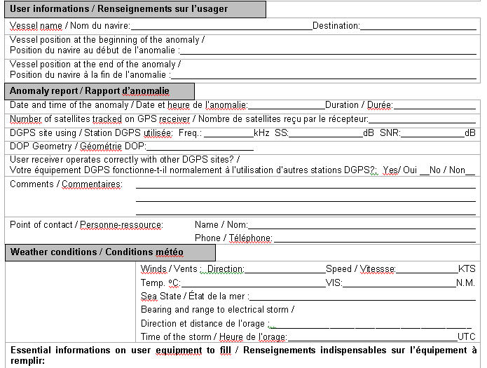
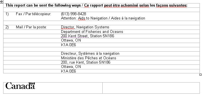
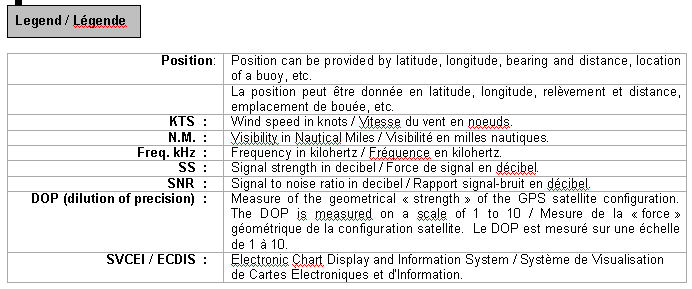
| DGPS station anomaly report / Rapport d'anomalie des stations DGPS |
|
With the purpose of constantly evaluating the quality of the DGPS service offered, the Canadian Coast Guard is providing the mariner with the following anomaly report. This report will allow us to get well-supported information concerning the anomaly and thus, will facilitate the identification of the origin of the problem. Please fill accordingly each section of this report and forward it by the suggested ways. You will find a legend at the end of this document. |
Avec le souci d'évaluer constamment la qualité du service DGPS offert, la Garde côtière met à la disposition du navigateur le présent rapport d'anomalie. Ce rapport servira à bien documenter l'anomalie et, de ce fait, facilitera l'identification ou la recherche de la source du problème. Nous vous prions de bien remplir chaque section de ce rapport et de l'acheminer de la façon suggérée. Vous trouverez une légende à la fin de ce document.

|
MONTHLY EDITION OF NOTICES TO MARINERS |
MAILING LIST CHANGES |
|
Leader, Notices to Mariners |
|
Navigation Aids |
|
Navigation Systems |
|
Canadian Coast Guard |
|
200 Kent Street, Station 5N186 |
|
Ottawa, ON |
|
K1A 0E6 |
|
Telephone (613) 990-3037 |
|
Facsimile (613) 998-8428 |
|
Internet www.notmar.gc.ca |
|
Please indicate which edition you would like to receive. |
|
EASTERN EDITION (Comprised of Arctic, Newfoundland, Maritimes, Gulf & River St. Lawrence and Central areas) ________ |
|
WESTERN EDITION (Comprised of Arctic and Pacific areas)________ |
|
|

|
INDEX
| |
|
CANADIAN COST GUARD - MARINE COMMUNICATION AND TRAFFIC SERVICES (MCTS). |
2 |
|
CANADIAN COAST GUARD PUBLICATION - AMENDMENT TO THE RADIO AIDS TO MARINE NAVIGATION (PACIFIC AND WESTERN ARCTIC) PUBLICATION 2007. |
11 |
|
CANADIAN HYDROGRAPHIC SERVICE - ANNOUNCEMENT REGARDING CANADIAN HYDROGRAPHIC SERVICE CHART PATCHES. |
1 |
|
CANADIAN HYDROGRAPHIC SERVICE - ARCTIC CHARTS. |
2 |
|
CANADIAN HYDROGRAPHIC SERVICE - CUMULATIVE CHART CORRECTIONS. |
1 |
|
CANADIAN HYDROGRAPHIC SERVICE - Current chart edition dates. |
1 |
|
CANADIAN HYDROGRAPHIC SERVICE - PRINT ON DEMAND CHARTS - CARE AND USE. |
1 |
|
*805 CANADIAN HYDROGRAPHIC SERVICE - BSB RASTER CHART CD "CHS DIGITAL CHARTS" PAC03 QUEEN CHARLOTTE SOUND - HECATE STRAIT TO PORTLAND CANAL 3728 MILBANKE SOUND AND APPROACHES/ET LES APPROCHES |
4 |
|
*802 CANADIAN HYDROGRAPHIC SERVICE - Electronic Navigation Charts. |
2 |
|
*804 CANADIAN HYDROGRAPHIC SERVICE - Non Equivalent Electronic Navigation Charts. |
3 |
|
*803 CANADIAN HYDROGRAPHIC SERVICE - Raster Navigation Charts. |
3 |
|
*806 HEALTH CANADA PUBLIC HEALTH AGENCY OF CANADA - INFORMATION BULLETIN - NO. 2007-01 August 20, 2007 - Canada's Quarantine Service - To: Conveyance Operators Using Canadian Points of Entry. |
3 |
|
NUMERICAL INDEX OF CANADIAN CHARTS AFFECTED | |||||
|
Chart No. |
Page |
Chart No. |
Page |
Chart No. |
Page |
|
3313 |
6 | ||||
|
3411 |
6 | ||||
|
3441 |
6 | ||||
|
3477 |
7 | ||||
|
3478 |
7 | ||||
|
3489 |
7 | ||||
|
3670 |
7 | ||||
|
3671 |
7 | ||||
|
3722 |
7,8 | ||||
|
3726 |
8 | ||||
|
3728 |
8 | ||||
|
3744 |
8 | ||||
|
3772 |
8 | ||||
|
L/C3902 |
8,9 | ||||
|
6416 |
9 | ||||
|
7621 |
9 | ||||
|
7665 |
9 | ||||
|
7687 |
9,10 | ||||
SECTION 1 – Edition 08/2007
SAFETY AND GENERAL INFORMATION
CANADIAN HYDROGRAPHIC SERVICE - ANNOUNCEMENT REGARDING CANADIAN HYDROGRAPHIC SERVICE CHART PATCHES.
CHS is introducing a new initiative with a full colour Patch on the Web. A link in the Notices to Mariners web site will be provided so clients can access the colour Patch. The colour Patch will be published in HTML and PDF format. Providing the Patches in colour (accessible to all via remote access to the Web) is an enhanced form of alternative service delivery in line with CHS strategic objectives.
Colour Web Patches are free to the mariner, and given the quality of many printers, should reproduce well. They will be available in real time all around the world which is an improvement since clients had to wait for the paper copy to be mailed.
Previously, in the Notices to Mariners (NTM) booklet, Patches were produced in full colour or a minimum of black and magenta.
Due to current budgetary constraints, Patches will now only be produced in black and white for publication in the NTM booklet.
Our level of service will change with this initiative and CHS intends to analyze market reaction to this innovation.
CHS welcomes your feedback on this new service at chsinfo@dfo-mpo.gc.ca
CANADIAN HYDROGRAPHIC SERVICE - CUMULATIVE CHART CORRECTIONS.
The cumulative Notice to Mariners corrections for charts can now be accessed at http://www.notmar.gc.ca/search/notmar-eng.php
CANADIAN HYDROGRAPHIC SERVICE - CURRENT CHART EDITION DATES.
|
CHART EDITIONS |
|
The three terms described below are used to indicate the publication status of Canadian charts. |
|
NEW CHART - "NEWCHT" |
|
The first publication of a Canadian chart embracing an area not previously charted to the scale shown, or embracing an area different from any existing Canadian chart. |
|
NEW EDITION - "NEWEDT" |
|
A new issue of an existing chart containing amendments essential to navigation in addition to those issued in Notice to Mariners and making existing editions obsolete. |
|
REPRINTS |
|
A new issue of the current edition of a chart incorporating no amendments of navigational significance other than those previously promulgated in Notice to Mariners. It may also contain amendments from other sources provided they are not essential to navigation. Previous printings of the current edition remain in force. |
The current chart edition dates can now be accessed at http://www.chs-shc.gc.ca/pub/en/products/core.cfm
CANADIAN HYDROGRAPHIC SERVICE - PRINT ON DEMAND CHARTS - CARE AND USE.
|
Background By providing nautical charts to the public, the goal of the Canadian Hydrographic Service (CHS) is to provide services for safe navigation in a fiscally responsible manner. As a result, CHS continues to expand its portfolio of nautical paper charts that are printed using Print On Demand (POD) technology. These charts are easily recognized by their whiter paper and the coloured logo of the Canadian Hydrographic Service. This new technology enables CHS to print charts in a more efficient manner while enhancing chart content through being able to quickly add new and important information. POD technology provides customers with up-to-date charts without the historical hand-drawn corrections or glued-on patches. Additionally, this technology eliminates out-of-stock situations which arise with the traditional printing and warehousing methods. In the event of a national emergency, CHS can respond to the appropriate authorities with best available information very quickly. Care of Your POD Chart CHS encourages its customers to handle the POD charts more carefully than the traditional lithographic charts. When plotting information on POD charts, use HB pencils and apply limited pressure. Testing has suggested that an Indian gum eraser is more effective than alternatives when used on the product. This eraser is also suitable for charts printed using lithographic processes. |
CANADIAN HYDROGRAPHIC SERVICE - ARCTIC CHARTS.
Please be advised that effective February 2007 all Arctic notices will appear in both the Eastern and Western paper editions of Notices to Mariners.
Mariners may obtain all Arctic chart notices via the Canadian Coast Guard Notices to Mariners online service www.notmar.gc.ca or by contacting the Canadian Coast Guard, Notices to Mariners office at the following coordinates:
Leader, Notices to Mariners
Aids to Navigation
Navigation Systems
Canadian Coast Guard
200 Kent Street, Station 5N186
Ottawa, ON
K1A 0E6
Telephone (613) 993-6974
Facsimile (613) 998-8428
CANADIAN COST GUARD - MARINE COMMUNICATION AND TRAFFIC SERVICES (MCTS).
Marine Communications and Traffic Services will no longer provide the radiotelegram service subject to full international charges after December 31st, 2007. However, messages addressed to "Quarantine" and messages requesting a doctor to meet a ship on arrival will now be handled without charge. MCTS will continue to provide a Marine Telephone Call Service subject to full international charges in selected areas, based upon demand and the availability of alternate service delivery methods.
*802 CANADIAN HYDROGRAPHIC SERVICE - ELECTRONIC NAVIGATION CHARTS.
|
RELEASED PRODUCTS |
|
|
S-57 ENC NUMBER |
CHART TITLE |
|
CA573327 |
Erieau - Entrance to Rondeau Bay |
|
CA373346 |
Melville Sound |
|
CA573347 |
Cape Croker |
|
CA573348 |
Roberts Bay |
|
CA373349 |
Bathurst Inlet - Northern Portion/Partie nord |
|
CA473350 |
Baychimo |
|
CA373351 |
Bathurst Inlet - Central Portion/Partie Centrale |
|
CA273357 |
Demarcation Bay to/à Liverpool Bay |
|
CA573359 |
Deception Bay |
|
CA573312 |
Wheatley Harbour |
|
CA479017 |
Donnacona à/to Batiscan |
|
CA479025 |
Sault-au Cochon à/to Quebec |
*803CANADIAN HYDROGRAPHIC SERVICE - RASTER NAVIGATION CHARTS.
|
CHARTS |
MAIN TITLE |
|
|
|
|
|
New Chart |
All temporary and preliminary notices affecting the previous versions of the following chart(s) (is / are) now cancelled. For any outstanding notices please consult section 2 of this edition. | ||||
|
R/M7220 |
Lancaster Sound, Eastern Approaches/ Approches Est |
|
02-NOV-1979 |
|
See Note 2 |
|
R/M7568 |
Lancaster Sound and/et Admiralty Inlet |
|
05-JUL-1985 |
|
See Note 2 |
|
R/M7569 |
Barrow Strait and/et Wellington Channel |
|
05-JUL-1985 |
|
See Note 2 |
|
R/M7571 |
Viscount Melville Sound |
|
11-APR-1986 |
|
See Note 2 |
|
R/M7572 |
Viscount Melville Sound and/et M'clure Strait |
|
02-MAY-1986 |
|
See Note 2 |
|
R/M7600 |
Beaufort Sea/ Mer de Beaufort |
|
26-JUL-1985 |
|
See Note 2 |
|
R/M7620 |
Demarcation Bay to/à Liverpool Bay |
|
02-MAY-1997 |
|
See Note 2 |
|
R/M7621 |
Amundsen Gulf |
|
02-MAY-1997 |
|
See Note 2 |
|
R/M7661 |
Demarcation Bay To/ A Philips Bay |
|
14-MAR-1986 |
|
See Note 2 |
|
R/M7662 |
Mackenzie Bay |
|
14-NOV-2003 |
|
See Note 2 |
|
R/M7663 |
Kugmallit Bay |
|
25-APR-1997 |
|
See Note 2 |
|
New Edition |
All temporary and preliminary notices affecting the previous versions of the following chart(s) (is / are) now cancelled. For any outstanding notices please consult section 2 of this edition. | ||||
|
R/M7121 |
Cape Mills to/à Cape Rammelsberg |
|
16-MAY-2003 |
|
See Note 2 |
|
R/M7122 |
Culbertson Island to/à Koojesse Inlet |
|
08-JUL-2005 |
|
See Note 2 |
|
R/M7127 |
Koojesse Inlet and Approaches/et les Approches |
|
15-AUG-2003 |
|
See Note 2 |
*804 CANADIAN HYDROGRAPHIC SERVICE - NON EQUIVALENT ELECTRONIC NAVIGATION CHARTS.
|
Note: |
The following ENC products are not equivalent to the current editions of their corresponding paper charts and should not be used as a replacement. |
|
NON EQUIVALENT PRODUCTS | ||
|
S-57 ENC NUMBER |
PAPER CHART NUMBER |
CHART TITLE |
|
CA176290 |
5001 |
Labrador Sea/Mer du Labrador |
|
CA276286 |
4023 |
Northhumberland Strait / Détroit de Northumberland |
|
CA276477 |
8013 |
Flemish Cap/Bonnet Flamand |
|
CA373067 |
2304 |
Oiseau Bay to/à Jackfish Bay |
|
CA376014 |
4242 |
Cape Sable Island to/aux Tusket Islands |
|
CA376045 |
4240 |
Liverpool Harbour to/à Lockeport Harbour |
|
CA376047 |
4241 |
Lockeport to/à Cape Sable |
|
CA376093 |
4367 |
Flint Island to/à Cape Smoky |
|
CA376094 |
4020 |
Strait of Belle Isle/Détroit de Belle Isle |
|
CA376212 |
5143 |
Lake Melville |
|
CA476179 |
4466 |
Hillsborough Bay |
|
CA476202 |
4211 |
Cape Lahave to/à Liverpool Bay |
|
CA476327 |
4596 |
Bay of Exploits Sheet/feuille II (Middle/centre) |
|
CA476328 |
4597 |
Bay of Exploits Sheet/feuille III (South/sud) |
|
CA576226 |
4587 |
Fishery Products International Wharves / Quais |
*805 CANADIAN HYDROGRAPHIC SERVICE - BSB RASTER CHART CD "CHS DIGITAL CHARTS" PAC03 QUEEN CHARLOTTE SOUND - HECATE STRAIT TO PORTLAND CANAL 3728 MILBANKE SOUND AND APPROACHES/ET LES APPROCHES
Some copies of this raster CD product have been found to have an error affecting Chart 3728, Milbanke Sound and Approaches/et les Approches. There is a positional error of 2.59 km along a grid or true bearing of 188°. It is recommended that this BSB chart not be used until a corrected copy can be obtained. The Canadian Hydrographic Service will contact all registered owners to arrange for a replacement.
If you require further information please contact: CHSInfo@dfo-mpo.gc.ca
*806 HEALTH CANADA PUBLIC HEALTH AGENCY OF CANADA - INFORMATION BULLETIN - NO. 2007-01 -AUGUST 20, 2007 - CANADA'S QUARANTINE SERVICE - TO: CONVEYANCE OPERATORS USING CANADIAN POINTS OF ENTRY.
CALL 1-800-545-7661 TO REPORT AN ILLNESS ON BOARD
Requirements for Advance Reporting under the new Quarantine Act
Background
Canada's new Quarantine Act [ SC 2005, c.20. Proclaimed in force, December 12, 2006.] came into force on December 12, 2006. The new Act replaces the previous Quarantine Act. [ R.S. 1985, c.Q-1.] The purpose of the new Act is to protect public health by taking comprehensive measures to prevent the introduction and spread of communicable diseases.
Section 34: Requirements for Conveyance Operators
Bill C-42, which amended the Quarantine Act by creating a new section 34, came into force on June 22, 20073 . This new section requires the operator of a conveyance used in the business of carrying persons or cargo, as soon as possible before the conveyance arrives at its destination in Canada, to inform a quarantine officer or cause a quarantine officer to be informed of any reasonable grounds to suspect that:
(a) any person, cargo or other thing on board the conveyance could cause the spreading of a communicable disease listed in the schedule;
(b) a person on board the conveyance has died; or
(c) any prescribed circumstances exist.

If it is not reasonably possible for a conveyance operator to inform a quarantine officer prior to arrival, notification must occur on the conveyance's arrival at its destination in Canada. In the case of conveyances arriving by land, "destination" is interpreted to mean a border crossing.
Once a quarantine officer is informed, border authorities will be alerted and preparations made to assess any travellers who may be a risk to public health. In the case of conveyances, cargo or other thing on board which may be contaminated or infested with vectors, the quarantine officer will inform an environmental health officer who may apply public health measures.
Attached to this bulletin is a Fact Sheet with Questions and Answers that will assist conveyance operators to comply with this legal obligation.
Please ensure that all relevant parties have ready access to this information. Please emphasize to them the importance of their role in preventing communicable diseases from crossing our borders.
Further Information
Electronic copies of the new Quarantine Act (prior to its amendment by Bill C-42) can be accessed through the following website:
http://www.parl.gc.ca/LEGISINFO/index.asp?Language=E&query=4219&Session=13&List=toc
If you have any questions, please contact your nearest quarantine station
|
Dr. Howard Njoo Acting Director General Centre for Emergency Preparedness and Response Public Health Agency of Canada |
Stephane Hardy Director General Workplace Health and Safety Programme Healthy Environments and Consumer Safety Branch Health Canada |
|
Canada's Quarantine Service is operated collaboratively by the Quarantine Program of the Public Health Agency of Canada and the Travelling Public Program of Health Canada, supported by the Canada Border Services Agency. Quarantine Officers, Environmental Health Officers and Border Services Officers work together at Canada's international border to help prevent the introduction and spread of communicable disease. |
Canada's Quarantine Stations
Vancouver Quarantine Station (responsible for all points of entry in British Columbia and the Yukon)
Office (604) 666-2499
Fax (604) 666-4947
24-hour (604) 317-1720
Toronto Quarantine Station (responsible for all points of entry in Ontario, west of Kingston, and Nunavut)
Office (905) 612-5397
Fax (905) 612-7987
24-hour (416) 315-5039
Montreal Quarantine Station (responsible for all points of entry in Quebec)
Office 514-633-3024 / 514-633-3015
Fax (514) 633-3031
24-hour (514) 229-2561
Calgary Quarantine Station (responsible for all points of entry in Alberta, Saskatchewan, Manitoba and the North
West Territories)
Office (403) 221-3068
Fax (403) 250-9271
24-hour (403) 221-3067
Ottawa Quarantine Station (responsible for all points of entry in Eastern Ontario)
Office (613) 949-2050
Fax (613) 949-1566
24-hour (613) 949-1565
Halifax Quarantine Station (responsible for all points of entry in Nova Scotia, New Brunswick, Prince Edward Island, and Newfoundland and Labrador)
Office (902) 873-7656
Fax (902) 873-7657
24-hour (902) 873-7659
SECTION 2 – Edition 08/2007
CHART CORRECTIONS
3313 - Portland Island - Sheet 9 - New Chart - 28-JUL-1995 - NAD 1983
|
03-AUG-2007 |
LNM/D. 30-MAR-2007 |
|
|
Amend |
note Chart/Carte 3476 to read Chart/Carte 3479 |
48°42'47.0"N 123°21'34.0"W |
|
DFO(6201699-09) | ||
3411 - Sooke - New Chart - 24-MAR-1995 - NAD 1983
|
10-AUG-2007 |
LNM/D. 24-MAR-2006 |
|
|
Delete |
mooring can buoy, marked Priv
|
48°21'43.4"N 123°43'23.5"W |
|
DFO(6201702-01) | ||
|
Delete |
mooring spherical buoy, marked Priv
|
48°21'41.6"N 123°43'19.7"W |
|
DFO(6201702-02) | ||
|
Delete |
red starboard hand spar buoy, marked Priv
|
48°22'29.7"N 123°42'55.8"W |
|
DFO(6201702-03) | ||
3441 - Haro Strait, Boundary Pass and/et Satellite Channel - New Edition - 01-JUL-2005 - NAD 1983
|
03-AUG-2007 |
LNM/D. 23-MAR-2007 |
|
|
Delete |
note Chart/Carte 3476 |
48°38'30.0"N 123°22'30.0"W |
|
DFO(6201699-01) | ||
|
Delete |
note Chart/Carte 3476 |
48°42'24.0"N 123°22'06.0"W |
|
DFO(6201699-02) | ||
|
Amend |
note Chart/Carte 3476 to read Chart/Carte 3479 |
48°43'02.0"N 123°26'18.0"W |
|
DFO(6201699-03) | ||
|
Add |
note Chart/Carte 3479 |
48°37'32.0"N 123°21'58.0"W |
|
DFO(6201699-04) | ||
|
Add |
note Chart/Carte 3479 |
48°41'28.0"N 123°18'15.0"W |
|
DFO(6201699-05) | ||
3477 - Bedwell Harbour to/à Georgeson Passage - New Edition - 03-MAY-1985 - NAD 1927
|
03-AUG-2007 |
LNM/D. (62-1997) |
|
|
Add |
note Chart/Carte 3479 |
48°44'02.0"N 123°16'18.0"W |
|
DFO(6201699-07) | ||
3478 - Fulford Harbour - New Edition - 17-JUN-2005 - NAD 1983
|
03-AUG-2007 | ||
|
Amend |
Adjoining Chart Carte adjacente 3476 to read Adjoining Chart Carte adjacente 3479 |
outside south border at 123° 25' 15"W |
|
DFO(6201699-06) | ||
3489 - Barnston Island to/à Crescent Island - Sheet 2 - New Chart - 21-OCT-1994 - NAD 1983
|
03-AUG-2007 |
LNM/D. 08-JUN-2007 |
|
|
Add |
fixed bridge
|
joining 49°11'59.5"N 122°40'00.7"W |
|
49°11'30.5"N 122°39'52.0"W |
||
|
49°11'30.6"N 122°39'51.2"W |
||
|
and 49°11'59.5"N 122°39'59.2"W |
||
|
DFO(6201700-01) | ||
|
Add |
legend Constr (2007) |
49°11'30.5"N 122°39'45.0"W |
|
DFO(6201700-02) | ||
3670 - Broken Group - New Edition - 21-OCT-1994 - NAD 1983
|
10-AUG-2007 |
LNM/D. 01-SEP-2006 |
|
|
Delete |
depth of 7.2 metres |
48°54'56.1"N 125°18'37.8"W |
|
DFO(6201703-01) | ||
|
Add |
depth of 2.4 metres |
48°54'56.1"N 125°18'37.9"W |
|
DFO(6201703-03) | ||
|
Add |
depth of 3.3 metres |
48°54'52.4"N 125°18'35.6"W |
|
DFO(6201703-04) | ||
3671 - Barkley Sound - New Edition - 04-NOV-2005 - NAD 1983
|
10-AUG-2007 |
LNM/D. 29-SEP-2006 |
|
|
Delete |
depth of 15.2 metres |
48°54'58.0"N 125°18'40.5"W |
|
DFO(6201703-02) | ||
|
Add |
depth of 2.4 metres |
48°54'56.1"N 125°18'37.9"W |
|
DFO(6201703-03) | ||
3722 - Union Passage and/et Tuwartz Inlet - New Edition - 30-DEC-2005 - NAD 1983
|
31-AUG-2007 | ||
|
Delete |
depth of 7.3 metres |
53°18'28.3"N 129°31'34.8"W |
|
DFO(6201708-01) | ||
|
Delete |
depth of 4.6 metres |
53°18'31.3"N 129°31'35.9"W |
|
DFO(6201708-02) | ||
|
Delete |
depth of 3.7 metres |
53°18'32.9"N 129°31'33.7"W |
|
DFO(6201708-03) | ||
|
Add |
depth of 1.7 metres |
53°18'28.8"N 129°31'35.2"W |
|
DFO(6201708-04) | ||
|
Add |
depth of 3.4 metres |
53°18'31.9"N 129°31'34.7"W |
|
DFO(6201708-05) | ||
|
Add |
depth of 4.7 metres |
53°18'57.2"N 129°31'23.5"W |
|
DFO(6201708-06) | ||
3726 - Laredo Sound and Approaches - New Edition - 23-MAY-1980 - Unknown
|
03-AUG-2007 |
LNM/D. 11-MAY-2007 |
|
|
Delete |
depth of 12 fathoms |
52°36'56.0"N 129°28'05.0"W |
|
DFO(6201701-01) | ||
|
Add |
depth of 9 fathoms |
52°36'54.6"N 129°28'04.1"W |
|
DFO(6201701-02) | ||
|
Add |
depth of 19 fathoms |
52°35'44.3"N 129°29'40.6"W |
|
DFO(6201701-03) | ||
|
24-AUG-2007 |
LNM/D. 03-AUG-2007 |
|
|
Delete |
depth of 10 fathoms |
52°20'05.8"N 128°45'42.0"W |
|
DFO(6201706-01) | ||
|
Add |
depth of ½ fathom |
52°20'03.5"N 128°45'36.7"W |
|
DFO(6201706-02) | ||
3728 - Milbanke Sound and Approaches/et les approches - New Edition - 05-FEB-1982 - NAD 1927
|
24-AUG-2007 |
LNM/D. 02-DEC-2005 |
|
|
Delete |
depth of 10 fathoms |
52°20'05.8"N 128°45'40.0"W |
|
DFO(6201706-01) | ||
|
Add |
depth of ½ fathom |
52°20'01.6"N 128°45'33.1"W |
|
DFO(6201706-02) | ||
3744 - Queen Charlotte Sound - New Edition - 20-MAY-1988 - NAD 1927
|
03-AUG-2007 |
LNM/D. 22-SEP-2006 |
|
|
Delete |
depth of 12 fathoms |
52°37'00.0"N 129°28'06.0"W |
|
DFO(6201701-01) | ||
|
Add |
depth of 9 fathoms |
52°36'52.7"N 129°28'00.4"W |
|
DFO(6201701-02) | ||
3772 - Grenville Channel, Sainty Point to Baker Inlet B-C - New Edition - 30-OCT-1964 - NAD 1927
|
24-AUG-2007 |
LNM/D. 13-FEB-2004 |
|
|
Reposition |
light Fl |
from 53°36'16.0"N 129°41'36.0"W |
|
to 53°36'13.1"N 129°41'31.8"W |
||
|
DFO(6201707-01) | ||
LC3902 - Hecate Strait - New Edition - 09-DEC-1988 - NAD 1927
|
03-AUG-2007 |
LNM/D. 11-MAY-2007 |
|
|
Delete |
depth of 12 fathoms |
52°37'00.0"N 129°28'06.0"W |
|
DFO(6201701-01) | ||
|
Add |
depth of 9 fathoms |
52°36'52.8"N 129°28'00.4"W |
|
DFO(6201701-02) | ||
|
Add |
depth of 19 fathoms |
52°35'42.4"N 129°29'36.9"W |
|
DFO(6201701-03) | ||
6416 - Saline Island to/à Police Island - New Edition - 29-APR-2005 - Unknown
|
24-AUG-2007 |
LNM/D. 20-APR-2007 |
|
|
Reposition |
legend Danger Zone 4
|
from 64°42'12.0"N 124°53'51.0"W |
|
to 64°41'09.0"N 124°51'36.0"W |
||
|
(A2007004) DFO(6602933-01) | ||
|
Amend |
legend F 18m to read F 33m against front leading light
|
64°42'07.0"N 124°56'58.0"W |
|
(A2007002) LL(1773.1) DFO(6602932-01) | ||
|
Amend |
legend F 27m to read F 43m against rear leading light
|
64°42'09.0"N 124°56'48.0"W |
|
(A2007003) LL(1773.2) DFO(6602935-01) | ||
7621 - Amundsen Gulf - New Chart - 02-MAY-1997 - NAD 1983
|
24-AUG-2007 |
LNM/D. 08-SEP-2000 |
|
|
Delete |
tower, Tr R Lts
|
69°21'03.0"N 124°04'31.0"W |
|
DFO(6602965-01) | ||
|
Amend |
legend Aero RC to read RC against radiobeacon
|
69°21'03.0"N 124°04'31.0"W |
|
DFO(6602965-05) | ||
|
Add |
aeronautical light, AERO
|
69°21'03.0"N 124°04'31.0"W |
|
DFO(6602965-06) | ||
7665 - Franklin Bay and/ et Darnley Bay - New Chart - 13-JUN-1986 - NAD 1927
|
24-AUG-2007 |
LNM/D. (1928-1999) |
|
|
Delete |
air obstruction light, Aero FR, Priv (PA) (See Chart No.1, P61.1) |
69°20'55.0"N 124°04'20.0"W |
|
DFO(6602965-02) | ||
|
Delete |
aeronautical radiobeacon, Aero RC
|
69°20'55.0"N 124°04'20.0"W |
|
DFO(6602965-03) | ||
|
Add |
circular radiobeacon, RC
|
69°21'03.0"N 124°04'31.0"W |
|
DFO(6602965-04) | ||
|
Add |
aeronautical light, AERO
|
69°21'21.0"N 124°04'32.0"W |
|
DFO(6602965-06) | ||
7687 - Approaches To/ Approches A Paulatuk Harbour - New Chart - 05-AUG-1983 - NAD 1927
|
24-AUG-2007 |
LNM/D. (1928-1999) |
|
|
Delete |
radio tower, Ro Tr, R Lts
|
69°21'06.0"N 124°04'03.0"W |
|
DFO(6602965-01) | ||
|
Delete |
air obstruction light, Aero FR, Priv (PA)
|
69°20'55.0"N 124°04'18.0"W |
|
DFO(6602965-02) | ||
|
Delete |
aeronautical radiobeacon, Aero RC
|
69°20'55.0"N 124°04'18.0"W |
|
DFO(6602965-03) | ||
|
Delete |
light Fl (PA) (See Chart No. 1, P1) |
69°20'52.0"N 124°03'55.0"W |
|
DFO(6602965-07) | ||
7687 - Paulatuk Harbour - New Chart - 05-AUG-1983 - No geographic reference
|
24-AUG-2007 |
LNM/D. (1928-1999) |
|
|
Delete |
radio tower, Ro Tr, R Lts
|
2825m, 67½° from bottom left corner of inset |
|
DFO(6602965-01) | ||
|
Delete |
air obstruction light, Aero FR, Priv (PA)
|
2525m, 73° from bottom left corner of inset |
|
DFO(6602965-02) | ||
|
Delete |
aeronautical radiobeacon, Aero RC
|
2525m, 73° from bottom left corner of inset |
|
DFO(6602965-03) | ||
|
Delete |
light Fl (PA)
|
2750m, 76½° from bottom left corner of inset |
|
DFO(6602965-07) | ||
|
Add |
circular radiobeacon, RC
|
2515m, 66½° from bottom left corner of inset |
|
DFO(6602965-04) | ||
|
Add |
aeronautical light, AERO
|
2780m, 56½° from bottom left corner of inset |
|
DFO(6602965-06) | ||
SECTION 3 – Edition 08/2007
CORRECTIONS TO RADIO AIDS TO MARINE NAVIGATION
CANADIAN COAST GUARD PUBLICATION - AMENDMENT TO THE RADIO AIDS TO MARINE NAVIGATION (PACIFIC AND WESTERN ARCTIC) PUBLICATION 2007.
Page -2-11
MCTS Tofino/VAE - Ship Shore Communications:
Communication site located at: Mount Ozzard
delete Channel 26.
Page 2-17
Victoria, British Columbia MCTS Center
Electronic-mail should read: mctsvictoria@pac.dfo-mpo.gc.ca
SECTION 4 – Edition 08/2007
SAILING DIRECTIONS AND SMALL CRAFT GUIDE CORRECTIONS
British Columbia, Volume 1, Seventeenth Ed ition, 2004 -
Page 37 - Paragraph 78, line 3
Delete: cautionary/information buoys and has
(P2007-15.01)
Page 38 - Before paragraph 116
Delete: Chart 3441
Replace by: Chart 3479
(P2007-15.02)
Page 40 - Top left column
Delete: Chart 3441
Replace by: Chart 3479
(P2007-15.03)
Page 40 - After paragraph 129
Insert: Chart 3441
(P2007-15.04)
Page 40 - After paragraph 137
Insert: Chart 3479
(P2007-15.05)
Page 40 - Paragraph 138, lines 2 and 3
Delete: A private mooring buoy is north of the wharf.
(P2007-15.06)
Page 40 - Paragraph 141, line 2
Delete: 1.5
Replace by: 1.7
(P2007-15.07)
Page 40 - After paragraph 144
Delete: Chart 3476
(P2007-15.08)
Page 40 - Before paragraph 147
Delete: Chart 3441
(P2007-15.09)
Page 40 - After paragraph 152
Delete: Charts 3441, 3476
(P2007-15.10)
Page 40 - Paragraph 153, line 1
Delete: east
Replace by: west
(P2007-15.11)
Page 40 - After paragraph 159
Delete: Chart 3441
(P2007-15.12)
Page 40 - Paragraph 164, line 2
Delete: 0.6 m
Replace by: 2 m
(P2007-15.13)
Page 41 - Top left column
Delete: Chart 3441
Replace by: Chart 3479
(P2007-15.14)
Page 41 - Before paragraph 165
Delete: Charts 3441, 3476
(P2007-15.15)
Page 41 - After paragraph 166
Delete: Chart 3476
(P2007-15.16)
Page 41 - Paragraph 171, line 3
Delete: cautionary/information buoys and has
(P2007-15.17)
Page 43 - Top left column
Delete: Chart 3476
Replace by: Chart 3479
(P2007-15.18)
Page 43 - Paragraph 189, line 1
Delete: Washington State Ferries terminal
Replace by: Sidney Ferry Terminal
(P2007-15.19)
Page 43 - Paragraph 198, line 5
Delete: with two private buoys used for traffic separation
(P2007-15.20)
Page 43 - Paragraph 200, line 1
Delete: Washington State Ferry landing
Replace by: Sidney Ferry Terminal
(P2007-15.21)
Page 43 - Delete paragraph 216.
(P2007-15.22)
Page 45 - Top left column
Delete: Chart 3476
Replace by: Chart 3479
(P2007-15.23)
Page 45 - Paragraph 233, line 5
Delete: 1.7 m
Replace by: 2.2 m
(P2007-15.24)
Page 47 - Top left column
Delete: Chart 3476
Replace by: Chart 3479
(P2007-15.25)
Page 47 - Delete paragraph 240.
(P2007-15.26)
Page 48 - Top left column
Delete: Chart 3476
Replace by: Chart 3479
(P2007-15.27)
Page 163 - After paragraph 259
Insert: 259.1 Golden Ears Bridge is a fixed span road bridge under construction and scheduled for completion mid 2009. Vertical clearance is planned to be 40 m. Channel width will be 170 m on the Bishops Reach (north) side and 120 m on the Parsons Channel (south) side.
(P2007-16.01)
SECTION 5 – Edition 08/2007
LIST OF LIGHTS, BUOYS AND FOG SIGNALS CORRECTIONS
|
PACIFIC | ||||||||||
|
225 G5339 |
Tom Point Sector |
On small islet E. of point. 48 39 44.4 123 16 25.6 |
Fl |
G-W |
4s |
6.4 |
7 |
White cylindrical tower, green band at top. |
Green from 171° to 181°; white from 181° to 171°. Radar reflector. Year round. Chart:3479 Edn 08/07(P07-034) |
|

|
INSTRUCTIONS: |
|
|
Mariners are requested to notify the responsible authorities when new or suspected dangers to navigation are discovered, changes are observed in aids to navigation, or corrections to publications are seen to be necessary. |
|
|
* In the case of new or suspected dangers to navigation, it is important that all details be given in order to aid with future investigations. Items of interest include heights, depths, physical description, type of bottom and equipment method used to position the item. It is helpful to mark details on chart, which will be promptly replaced by the Canadian Hydrographic Service. |
|
|
Reports should be made to the nearest Marine Communications and Traffic Services Centre and should be confirmed in writing to: | |
|
Director, Navigation Systems |
In the case of information concerning |
OR | |
|
Dominion Hydrographer |
In the case of new or suspected |
For general questions on Coast Guard programs or services, please send an e-mail message to:
info@dfo-mpo.gc.ca
(Please include your postal and e-mail address)