
Archived information
The Standard on Web Usability replaces this content. This content is archived because Common Look and Feel 2.0 Standards have been rescinded.
Archived information is provided for reference, research or recordkeeping purposes. It is not subject to the Government of Canada Web Standards and has not been altered or updated since it was archived.
|
|
Fisheries and Oceans Canada |
Pêches et Ocèans Canada |
|
 |
|||
| MONTHLY EDITION N° 8 August, 29th, 2014 |
|||
|
CONTENTS |
|||
Page |
|||
| Section 1 |
Safety and General Information | 1 - 7 |
|
| Section 2 |
Chart Corrections | 8 - 20 |
|
| Section 3 |
Radio Aids to Marine Navigation Corrections | N/A |
|
| Section 4 |
Sailing Directions and Small Craft Guide Corrections | 21 |
|
| Section 5 |
List of Lights, Buoys and Fog signals Corrections | 22 - 23 |
|
Maritime Services Directorate Aids to Navigation |
|||
Fisheries and Oceans Canada - Official publication of the Canadian Coast Guard |
|||

Geographical positions refer directly to the graduations of the largest scale Canadian Hydrographic chart unless otherwise indicated.
Bearings refer to the true compass and are measured clockwise from 000° (North) clockwise to 359°; those relating to lights are from seaward.
Visibility of lights is that in clear weather.
Depths - The units used for soundings (metres, fathoms or feet) are stated in the title of each chart.
Elevations are normally given above Higher High Water, Large Tides unless otherwise indicated.
Distances may be calculated as follows:
1 nautical mile = 1 852 metres (6,076.1 feet)
1 statute mile = 1 609.3 metres (5,280 feet)
1 metre = 3.28 feet
Temporary & Preliminary Notices are indicated by a (T) or a (P) before the chart action and in the section 1. Please note that Nautical charts are not amended by the Canadian Hydrographic Service for Temporary (T) and Preliminary (P) Notices. It is recommended that mariners chart these corrections in pencil. Listing of charts affected by Temporary and Preliminary Notices are revised and promulgated quarterly in Section 1 of the Monthly Edition.
Please note that, in addition to the temporary and preliminary changes normally advertised as (T) and (P) Notices, there are a few permanent changes to navigational aids that have been advertised as Preliminary Notices to Mariners while charts are being updated for new editions.
Marine Information Report & Suggestion Sheet - Mariners are requested to notify the responsible authorities when new or suspected dangers to navigation are discovered, changes observed in aids to navigation or corrections to publications are seen to be necessary. Such communications can be made using the Marine Information Report & Suggestion Sheet inserted on the last page of each monthly edition of Notices to Mariners.
Canadian Hydrographic Service - Information Published in Section 2 Notices to Mariners - Mariners are advised that only the most critical changes that directly affect safety to navigation are issued in Chart Corrections - Section 2. This limitation is required to ensure that charts remain as clear and easy to read as possible. As a result, mariners may see minor discrepancies of a non-critical nature between information in official publications. For example, a small change in the nominal range or height of a light may not result in the production of a chart correction, in Notices to Mariners, but may result in a List of Light, Buoys and Fog Signals correction.
In case of discrepancy between information provided on CHS charts related to aids to navigation, and the List of Light publication, the latter shall be deemed as containing the most up to date information
Canadian Nautical Charts & Publications - A source list of Canadian Nautical Charts & Publications is published in Notice No. 14 of the Notices to Mariners Annual Edition April 2011. The source supply and the prices effective at the time of printing are listed. For current chart edition dates refer to the following web site: http://www.chs-shc.gc.ca/charts-cartes/paper-papier/index-eng.asp
NOTE: Cette publication est aussi disponible en français.
Corrections to nautical charts will be listed in numeric order by chart number. Each chart correction listed applies only to that particular chart. Related charts, if any, will have their own specific correction listed separately.
Users should also refer to CHS Chart 1 Symbols, Abbreviations Terms for additional information pertaining to the correction of charts.
The illustration below describes the elements that will comprise a typical Section 2 chart correction.

MONTHLY EDITION OF NOTICES TO MARINERS
WEB ACCESS
We are offering a feature where subscribers to our on-line service are able to receive the complete electronic monthly edition of
our Notices to Mariners. We are encouraging our clients to visit the web site to subscribe for this service:
http://www.notmar.gc.ca/subscribe/
Users wishing to receive information updates for their charts can do so by setting up a ’User Profile’ on the following web page http://www.notmar.gc.ca/search/mycharts-eng.php?czoxOToibnRtPXN0ZXBfb25lJmxhbmc9ZSI7
This feature permits users to register the nautical charts they currently have in their possession. Registrants are then automatically notified by e-mail when a Notice to Mariners is published concerning these charts.
ADVISORY
NOTICES TO SHIPPING (WRITTEN AND BROADCAST)
The Canadian Coast Guard is implementing a number of changes to the aids to navigation system in Canada.
These changes are advertised as Notices to Shipping (Broadcast and Written) by the Canadian Coast Guard and are followed up with Notices to Mariners, then charts are updated by hand correction, reprints or new editions.
Mariners are advised that all relevant Written Notices to Shipping should be kept until superseded by Notices to Mariners or through revised charts issued by the Canadian Hydrographic Service.
Written Notices to Shipping are available on the Canadian Coast Guard Website at: www.ccg-gcc.gc.ca/eng/CCG/NOTSHIP.
The Canadian Hydrographic Service is reviewing the impact of these changes with the Canadian Coast Guard and together we are preparing an action plan on the issuing of chart revisions.
For further information contact your local Regional Notices to Shipping (NOTSHIP) issuing authorities.
|
Newfoundland |
Maritimes |
|
Quèbec |
Central & Arctic *Fisheries and Oceans Canada |
* Services provided in English and French
INDEX
| CANADIAN HYDROGRAPHIC SERVICE - ANNOUNCEMENT REGARDING CANADIAN HYDROGRAPHIC SERVICE CHART PATCHES | 1 |
| CANADIAN HYDROGRAPHIC SERVICE - CUMULATIVE CHART CORRECTIONS | 1 |
| CANADIAN HYDROGRAPHIC SERVICE - CURRENT CHART EDITION DATES | 1 |
| CANADIAN HYDROGRAPHIC SERVICE - PRINT ON DEMAND CHARTS - CARE AND USE | 1 |
| CANADIAN HYDROGRAPHIC SERVICE - TRANSPORT CANADA NAVIGATION SAFETY – ECDIS | 2 |
| CONSOLIDATION OF MARINE COMMUNICATIONS AND TRAFFIC SERVICES (MCTS) CENTRES | 2 |
| CANADIAN COAST GUARD PUBLICATION - RADIO AIDS TO MARINE NAVIGATION (ATLANTIC, ST. LAWRENCE, GREAT LAKES, LAKE WINNIPEG AND EASTERN ARCTIC) PUBLICATION – 2013 - THE COMMERCIAL PUBLIC CORRESPONDENCE SERVICE | 2 |
| ERRATUM: Reference Notice 604(P)/2014 | 3 |
| *801 SAGUENAY-ST. LAWRENCE MARINE PARK AND SURROUNDING WATERS - WHALE PROTECTION | 3 |
| *802 CANADIAN HYDROGRAPHIC SERVICE – NAUTICAL CHARTS | 5 |
| *804 CANADIAN HYDROGRAPHIC SERVICE - RASTER DIGITAL CHARTS (BSB V4) | 5 |
| *805 CANADIAN HYDROGRAPHIC SERVICE – SAILING DIRECTIONS – CEN 307 - NORTH CHANNEL OF LAKE HURON, FIRST EDITION, 2000 IS NOW AVAILABLE AS PRINT-ON-DEMAND (POD) PRODUCT | 6 |
| *806 TRANSPORT CANADA - SHIP SAFETY BULLETIN | 6 |
| *807 CANADIAN COAST GUARD PUBLICATIONS - NEW EDITION OF RADIO AIDS TO MARINE NAVIGATION (ATLANTIC, ST. LAWRENCE, GREAT LAKES, LAKE WINNIPEG AND ARCTIC) – 2014 | 6 |
| *808 SYDNEY HARBOUR – LIGHT BUOY DISCONTINUED | 6 |
| *809(P) SYDNEY HARBOUR – LIGHT BUOY DISCONTINUED | 6 |
| *810(P) LOCKEPORT TO/À CAPE SABLE - FOG SIGNAL TO BE DISCONTINUED | 6 |
| *811(P) HAMILTON SOUND, EASTERN PORTION / PARTIE EST - FOG SIGNAL TO BE DISCONTINUED. | 7 |
| *813 INDIAN BAY TO/À WADHAM ISLANDS- FOG SIGNAL TO BE DISCONTINUED | 7 |
|
NUMERICAL INDEX OF CANADIAN CHARTS AFFECTED. |
|||||
|
Chart No. |
Page |
Chart No. |
Page |
Chart No. |
Page |
|
1311 |
8 |
4911 |
19 |
||
|
1312 |
8 |
4913 |
19 |
||
|
1313 |
9,10 |
5051 |
4 |
||
|
1314 |
10,12 |
5452 |
19 |
||
|
2250 |
12,13 |
7220 |
19 |
||
|
2283 |
13,14 |
7750 |
20 |
||
|
3939 |
4 |
||||
|
4026 |
4, 14 |
||||
|
4114 |
14 |
||||
|
4115 |
14 |
||||
|
4118 |
14 |
||||
|
4237 |
15 |
||||
|
4241 |
6 |
||||
|
4266 |
6,15 |
||||
|
4275 |
4 |
||||
|
4277 |
15 |
||||
|
4335 |
15 |
||||
|
4367 |
16 |
||||
|
4385 |
16 |
||||
|
4466 |
16,17 |
||||
|
4530 |
7 |
||||
|
4825 |
17 |
||||
|
4846 |
17 |
||||
|
4847 |
18 |
||||
|
4848 |
18 |
||||
|
4857 |
7,18 |
||||
SECTION 1
SAFETY AND GENERAL INFORMATION
CANADIAN HYDROGRAPHIC SERVICE - ANNOUNCEMENT REGARDING CANADIAN HYDROGRAPHIC SERVICE CHART PATCHES
Colour Web Patches are free to the mariner, and given the quality of many printers, should reproduce well. They will be available in real time all around the world.
CHS welcomes your feedback on this service at chsinfo@dfo-mpo.gc.ca .
CANADIAN HYDROGRAPHIC SERVICE - CUMULATIVE CHART CORRECTIONS
The cumulative Notices to Mariners corrections for charts can now be accessed at
www.notmar.gc.ca/search/notmar-eng.php .
CANADIAN HYDROGRAPHIC SERVICE - Current chart edition dates
CHART EDITIONS
The three terms described below are used to indicate the publication status of Canadian charts.
NEW CHART - "NEWCHT"
The first publication of a Canadian chart embracing an area not previously charted to the scale shown, or embracing an area different from any existing Canadian chart.
NEW EDITION - "NEWEDT"
A new issue of an existing chart containing amendments essential to navigation in addition to those issued in Notices to Mariners and making existing editions obsolete.
REPRINTS
A new issue of the current edition of a chart incorporating no amendments of navigational significance other than those
previously promulgated in Notices to Mariners. It may also contain amendments from other sources provided they
are not essential to navigation. Previous printings of the current edition remain in force.
The current chart edition dates can be accessed at
www.chs-shc.gc.ca/charts-cartes/paper-papier/index-eng.asp
CANADIAN HYDROGRAPHIC SERVICE - PRINT ON DEMAND CHARTS - CARE AND USE
Background
By providing nautical charts to the public, the goal of the Canadian Hydrographic Service (CHS) is to provide services for safe navigation in a fiscally responsible manner. As a result, CHS continues to expand its portfolio of nautical paper charts that are printed using Print On Demand (POD) technology. These charts are easily recognized by their whiter paper and the coloured logo of the Canadian Hydrographic Service. This new technology enables CHS to print charts in a more efficient manner while enhancing chart content through being able to quickly add new and important information. POD technology provides customers with up-to-date charts without the historical hand-drawn corrections or glued-on patches. Additionally, this technology eliminates out-of-stock situations which arise with the traditional printing and warehousing methods. In the event of a national emergency, CHS can respond to the appropriate authorities with best available information very quickly.
Care of Your POD Chart
CHS encourages its customers to handle the POD charts more carefully than the traditional lithographic charts. When plotting information on POD charts, use HB pencils and apply limited pressure. Testing has suggested that an Indian gum eraser is more effective than alternatives when used on the product. This eraser is also suitable for charts printed using lithographic processes.
CANADIAN HYDROGRAPHIC SERVICE - TRANSPORT CANADA NAVIGATION SAFETY - ECDIS
Mariners are advised that ECDIS may not display some isolated shoal depths when operating in "base or standard display" mode. Route planning and monitoring alarms for these shoal depths may not always be activated. To ensure safe navigation and to confirm that a planned route is clear of such dangers, mariners should visually inspect the planned route and any deviations from it using ECDIS configured to display "all data". The automated voyage planning check function should not be solely relied upon.
CONSOLIDATION OF MARINE COMMUNICATIONS AND TRAFFIC SERVICES (MCTS) CENTRES.
The Canadian Coast Guard is consolidating and modernizing its Marine Communications and Traffic Services.
These changes will result in a configuration of 12 MCTS Centres strategically located across the country.
Information pertaining to consolidation will be advertised to clients by all available means.
Atlantic Region
St. John’s MCTS will close; services will be provided remotely by Placentia MCTS
Saint John (Fundy) MCTS will close; services will be provided remotely by Halifax MCTS
St. Anthony MCTS will close; services will be provided remotely by Labrador (Goose Bay) MCTS
Central & Arctic Region
Montreal MCTS will close; services will be provided remotely by Quebec MCTS
Thunder Bay MCTS will close; services will be provided remotely by Sarnia MCTS
Rivière-au-Renard MCTS will close; services will be provided remotely by Les Escoumins MCTS
There will be no reduction in the MCTS level of service provided to clients. Mariners should be aware
that, as a result of consolidation, contact information, weather and other pertinent marine broadcast schedules
may change. These changes will be advertised in RAMN, as they become available.
Mariners should check NOTMAR PART 3 on a monthly basis for updates.
CANADIAN COAST GUARD PUBLICATION - RADIO AIDS TO MARINE NAVIGATION (ATLANTIC, ST. LAWRENCE, GREAT LAKES, LAKE WINNIPEG AND EASTERN ARCTIC) PUBLICATION - 2013 - The Commercial Public Correspondence Service.
Part I - Page 1 of 10
ADVANCE NOTICES
The Commercial Public Correspondence Service
Effective January 1, 2014, the following changes to the Canadian Coast Guard commercial public correspondence service, provided through select Marine Communications and Traffic Services centres, will be in effect: All long distance ship-shore calls will be administered through the regular telephone service provider as acollect call. Individuals intending to placeshore-ship calls will be required to direct-dial the appropriate MCTS centre. MCTS centres providing a commercial public correspondence service are identified in RAMN, Part 2.
ERRATUM: REFERENCE NOTICE 604(P)/2014
AMEND
Reference Chart: 4679
TO READ
Reference Chart: 4130
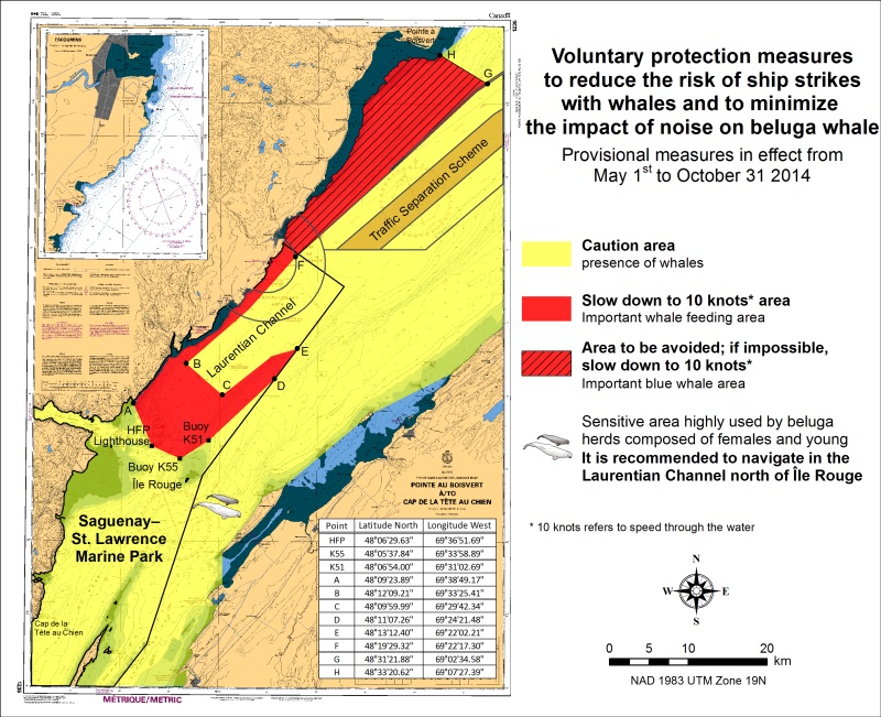
*801 SAGUENAY-ST. LAWRENCE MARINE PARK AND SURROUNDING WATERS - WHALE PROTECTION
The waters in and around the Saguenay-St. Lawrence Marine Park are well known for their resident threatened beluga population and the wide diversity of whales that migrate there to feed, particularly between April and November.
REGULATORY PROTECTION MEASURES
All whale species that are found in the St. Lawrence are protected under the Marine Mammal Regulations, pursuant to the Fisheries Act. Within the boundaries of the Marine Park, specific measures are set out in the Marine Activities in the Saguenay–St. Lawrence Marine Park Regulations, pursuant to the Act Establishing the Saguenay-St. Lawrence Marine Park. Any collision with a marine mammal within the Marine Park must immediately be reported to a park warden at 1-866-508-9888. For collisions that occur outside the Marine Park or for any situation involving a marine mammal that is dead or in trouble, contact the emergency network at 1-877-722-5346 or on channel 16. (see section 5C of the Annual Edition of the Notices to Mariners – April 2014 to March 2015).
VOLUNTARY PROTECTION MEASURES
Provisional measures in effect from May 1 to October 31, 2014
These measures apply to merchant vessels and cruise ships between Pointe à Boisvert and Cap de la Tête au Chien to prevent collisions with whales (see link below to view map). These measures should only be taken when they will not jeopardize navigational safety.
Caution area (yellow area): To reduce the risk of collisions with whales that can be present anywhere in this area, heightened vigilance is critical for navigators. Posting a lookout is recommended in order to increase the chances of seeing the whales and thus taking necessary measures to avoid them. If bypassing the whales is not possible, slow down and wait for the animals to move away to a distance greater than 400 meters (0.215 nautical miles) before resuming original speed. It is more difficult to see the animals at night therefore increased caution is recommended. Slow down to 10 knots area (red area): To reduce the risk of collisions with whales in this feeding area, it is recommended that vessels slow down to a maximum speed through the water of 10 knots and post a lookout. It is further recommended to remain in the Laurentian Channel to the north of île Rouge to minimize the impact of noise in a sensitive area south of this island, which is highly frequented by herds of beluga whales composed of females and young.
Area to be avoided (hatched red area): To reduce noise and the risk of collisions with whales, vessels should avoid transiting through this area which is highly frequented by blue whales, an endangered species. If the area cannot be avoided, slow down to a maximum speed through the water of 10 knots.
See attached map:
*802 CANADIAN HYDROGRAPHIC SERVICE - NAUTICAL CHARTS
|
CHARTS |
MAIN TITLE |
SCALE |
PUBLISHED |
CAT# |
PRICE |
|
New Editions |
|||||
|
3939 |
Fisher Channel to/à Seaforth Channel and/et Dean Channel |
1:40000 |
01-AUG-2014 |
2 |
20.00 |
|
4026 |
Havre Saint-Pierre et/and Cap des Rosiers à/to Pointe des Monts |
1:300000 |
23-MAY-2014 |
1 |
20.00 |
|
4275 |
St. Peters Bay |
1:20000 |
28-MAR-2014 |
1 |
20.00 |
|
5051 |
Nunaksuk Island to/à Calf Cow and/et Bull Islands |
1:60000 |
25-APR-2014 |
1 |
20.00 |
*803 CANADIAN HYDROGRAPHIC SERVICE - ELECTRONIC NAVIGATIONAL CHARTS
|
NEW PRODUCTS |
|
|
S-57 ENC NUMBER |
CHART TITLE |
|
CA376691 |
Cape George to/à Pictou |
|
CA576692 |
Ballantynes Cove Wharf/Quai |
|
CA576693 |
Cribbons Point Wharf/Quai |
|
CA576694 |
Arisaig Wharf/Quai |
|
CA576695 |
Lismore Wharf/Quai |
|
WITHDRAWN PRODUCTS |
|
|
CA573309 |
Parry Sound Harbour |
|
CA573310 |
Rose Island Channel |
*804 CANADIAN HYDROGRAPHIC SERVICE - RASTER DIGITAL CHARTS (BSB V4)
|
CHARTS |
MAIN TITLE |
SCALE |
PUBLISHED |
|
New Charts |
|||
|
R/M1201 |
Saint-Fulgence à/to Saguenay |
1:15000 |
07-FEB-2014 |
|
R/M1360 |
Lac Memphrémagog |
1:30000 |
23-MAY-2014 |
|
R/M4404 |
Cape George to/à Pictou |
1:75888 |
28-FEB-2014 |
|
New Editions |
|||
|
R/M2250 |
Bruce Mines to/à Sugar Island |
1:25000 |
28-FEB-2014 |
|
R/M3936 |
Fitz Hugh Sound to/à Lama Passage |
1:40000 |
21-MAR-2014 |
|
R/M4025 |
Cap Whittle à/to Havre-Saint-Pierre et/and Île d'Anticosti |
1:300000 |
28-MAR-2014 |
|
R/M4266 |
Sydney Harbour |
1:20000 |
28-FEB-2014 |
|
R/M4275 |
St. Peters Bay |
1:20000 |
28-MAR-2014 |
|
R/M5051 |
Nunaksuk Island to/à Calf Cow and/et Bull Islands |
1:60000 |
25-APR-2014 |
|
R/M7950 |
Jones Sound,Norwegian Bay and Queens Channel |
1:500000 |
21-JUN-2013 |
*805 CANADIAN HYDROGRAPHIC SERVICE - SAILING DIRECTIONS - CEN 307 - North Channel of Lake Huron, First Edition, 2000 is now available as Print-on-Demand (POD) product.
The Sailing Directions booklet is now available as Print-on-Demand (POD) product. POD booklets are updated through Notices to Mariners to the date of printing. For instance, the POD version of CEN 307 now incorporates some 148 Notices to Mariners issued since 2000, which previously had to be manually added to the book. The Canadian Hydrographic Service (CHS) is converting all of its Sailing Directions to the POD format in response to requests received through our Level of Service initiative. Contact an authorized CHS dealer to purchase a new copy.
Please note that despite the new look, the content remains the same except that the Notices to Mariners have been incorporated up to the date of printing.
*806 Transport Canada - ship safety bulletin
An updated Ship Safety Bulletin has recently been posted to the Transport Canada website at
To go online to view or download this bulletin, please click on the link below:
Note: Sign yourself up for e-Bulletin to receive an e-mail notice each time a new Ship Safety Bulletin is published on our Website.
Contact us at marinesafety-securitemaritime@tc.gc.ca or 1-855-859-3123 (Toll Free).
*807 CANADIAN COAST GUARD PUBLICATIONS - NEW EDITION OF RADIO AIDS TO MARINE NAVIGATION (ATLANTIC, ST. LAWRENCE, GREAT LAKES, LAKE WINNIPEG AND ARCTIC) - 2014.
The 2014 edition of the Radio Aids to Marine Navigation (Atlantic, St. Lawrence, Great Lakes, Lake Winnipeg and Arctic) is now available for download, free of charge, on the Marine Communications and Traffic Services MCTS website: http://www.ccg-gcc.gc.ca/Marine-Communications/Home
Paper copies of the publication are no longer sold.
Amendments to this publication are advertised by radio broadcast (Notices to Shipping) and/or in Section 3 of the monthly edition of Notices to Mariners www.notmar.gc.ca
The 2014 edition has been revised to July 25, 2014 and supersedes the 2013 edition.
*808 Sydney Harbour - light buoy DISCONTINUED.
Reference: Notice 608(P)/2012 is now cancelled. (Chart 4266)
(G2014062)
809 Sydney Harbour - light buoy DISCONTINUED
Reference: Notice 609(P)/2012 is now cancelled. (Chart 4266)
(G2014063)
*810(P)Lockeport to/à Cape Sable - Fog Signal to be discontinued.
Reference Chart: 4241
The Canadian Coast Guard proposes to permanently discontinue the following Aid to navigation:
Baccaro Point Fog Signal LL 336 (43° 26' 59"N 65° 28' 15"W).
Comments on this action are solicited from mariners and other interested parties.
Comments should be directed to the following within three months from the date of this notice:
A\Regional Superintendent,
Aids to Navigation & Waterways,
Canadian Coast Guard,
PO Box 5667,
St. John's, NL, A1C 5X1
Telephone: 709-772-5195,
Email: Renee.Pope@dfo-mpo.gc.ca
Any objections raised must state the facts on which they are based and should include supporting information on safety, commerce and public benefit.
(F2014-025)
*811(P)Hamilton Sound, Eastern Portion / Partie est - Fog Signal to be discontinued.
Reference Chart: 4530
The Canadian Coast Guard proposes to permanently discontinue the following Aid to navigation:
Peckford Island Fog Signal LL 395 (49° 31' 49.6"N 53° 51' 04.8"W).
Comments on this action are solicited from mariners and other interested parties.
Comments should be directed to the following within three months from the date of this notice:
A\Regional Superintendent,
Aids to Navigation & Waterways,
Canadian Coast Guard,
PO Box 5667,
St. John's, NL, A1C 5X1
Telephone: 709-772-5195,
Email: Renee.Pope@dfo-mpo.gc.ca
Any objections raised must state the facts on which they are based and should include supporting information on safety, commerce and public benefit.
(N2014-039)
*812(P) indian bay to/à wadham islands - Fog Signal to be discontinued.
Reference Chart: 4857
The Canadian Coast Guard proposes to permanently discontinue the following Aid to navigation:
Cabot Islands Fog Signal LL 406 (49° 10' 28.1"N 53° 22' 03.3"W).
Comments on this action are solicited from mariners and other interested parties.
Comments should be directed to the following within three months from the date of this notice:
A\Regional Superintendent,
Aids to Navigation & Waterways,
Canadian Coast Guard,
PO Box 5667,
St. John's, NL, A1C 5X1
Telephone: 709-772-5195,
Email: Renee.Pope@dfo-mpo.gc.ca
Any objections raised must state the facts on which they are based and should include supporting information on safety, commerce and public benefit.
(N2014-040)
1311 - Sorel-Tracy à/to Varennes - New Edition - 19-SEP-2013 - NAD 1983
|
08-AUG-2014 |
LNM/D. 18-JUL-2014 |
||
|
Delete |
depth of 4 metres 6 decimetres |
46°04′07.9″N 073°05′19.6″W |
|
|
This notice affects Electronic Navigational Chart: CA479129 |
|||
|
DFO(6408908-04) |
|||
|
Add |
depth of 3 metres 5 decimetres |
46°04′09.4″N 073°05′18.8″W |
|
|
This notice affects Electronic Navigational Chart: CA479129 |
|||
|
DFO(6408908-05) |
|||
1312 - Lac Saint-Pierre - New Edition - 24-MAY-2013 - NAD 1983
|
08-AUG-2014 |
LNM/D. 18-JUL-2014 |
||
|
Replace |
yellow cautionary lighted spar buoy Fl Y, marked LAC with yellow cautionary lighted pillar buoy Fl Y, marked LAC |
46°16′03.1″N 072°41′43.4″W |
|
|
This notice affects Electronic Navigational Chart: CA479129 |
|||
|
(Q2014019) LL(2123.5) DFO(6408901-01) |
|||
|
Replace |
wreck Wk with known depth of 2 metres 4 decimetres with |
46°04′16.8″N 073°04′43.5″W |
|
|
This notice affects Electronic Navigational Chart: CA479129 |
|||
|
DFO(6408908-01) |
|||
|
Delete |
depth of 0 metres 7 decimetres |
46°04′12.4″N 073°04′25.6″W |
|
|
This notice affects Electronic Navigational Chart: CA479129 |
|||
|
DFO(6408908-02) |
|||
|
Add |
wreck Wk with known depth of 0 metres 8 decimetres |
46°04′12.0″N 073°04′25.6″W |
|
|
This notice affects Electronic Navigational Chart: CA479129 |
|||
|
DFO(6408908-03) |
|||
|
Delete |
depth of 4 metres 6 decimetres |
46°04′07.9″N 073°05′19.6″W |
|
|
This notice affects Electronic Navigational Chart: CA479129 |
|||
|
DFO(6408908-04) |
|||
|
Add |
depth of 3 metres 5 decimetres |
46°04′09.4″N 073°05′18.8″W |
|
|
This notice affects Electronic Navigational Chart: CA479129 |
|||
|
DFO(6408908-05) |
|||
1313 - Batiscan au/to Lac Saint-Pierre - New Edition - 07-JUN-2013 - NAD 1983
|
22-AUG-2014 |
LNM/D. 08-AUG-2014 |
||
|
Amend |
vertical clearance of 32 metres, to read 3 metres 2 decimetres |
46°21′16.5″N 072°26′19.8″W |
|
|
DFO(6408946-07) |
|||
|
Amend |
vertical clearance of 41 metres, to read 4 metres 1 decimetre |
46°23′01.4″N 072°20′15.5″W |
|
|
DFO(6408946-08) |
|||
|
Amend |
vertical clearance of 43 metres, to read 4 metres 3 decimetres |
46°27′08.4″N 072°17′02.1″W |
|
|
DFO(6408946-09) |
|||
|
Amend |
vertical clearance of 87 metres, to read 8 metres 7 decimetres |
46°27′00.4″N 072°16′49.0″W |
|
|
DFO(6408946-10) |
|||
|
Amend |
vertical clearance of 85 metres, to read 8 metres 5 decimetres |
46°26′20.2″N 072°13′25.7″W |
|
|
DFO(6408946-11) |
|||
|
08-AUG-2014 |
LNM/D. 27-DEC-2013 |
||
|
Replace |
yellow cautionary lighted spar buoy Fl Y, marked LAC with yellow cautionary lighted pillar buoy Fl Y, marked LAC |
46°16′03.1″N 072°41′43.4″W |
|
|
This notice affects Electronic Navigational Chart: CA479129 |
|||
|
(Q2014019) LL(2123.5) DFO(6408901-01) |
|||
1313 - Port de Trois-Rivières - New Edition - 07-JUN-2013 - NAD 1983
|
29-AUG-2014 |
LNM/D. 22-AUG-2014 |
||
|
Delete |
depth of 9 metres 5 decimetres |
46°20′41.5″N 072°31′53.8″W |
|
|
This notice affects Electronic Navigational Chart: CA579015 |
|||
|
DFO(6408944-16) |
|||
|
Add |
depth of 8 metres 8 decimetres |
46°20′41.2″N 072°31′54.2″W |
|
|
This notice affects Electronic Navigational Chart: CA579015 |
|||
|
DFO(6408944-17) |
|||
|
Amend |
10,8 m (2010) to read 10,4 m (2013) |
46°20′03.5″N 072°32′35.0″W |
|
|
This notice affects Electronic Navigational Chart: CA579015 |
|||
|
DFO(6408944-18) |
|||
|
22-AUG-2014 |
LNM/D. 08-AUG-2014 |
||
|
Amend |
vertical clearance of 35 metres, to read 3 metres 5 decimetres |
46°21′46.6″N 072°31′54.4″W |
|
|
DFO(6408946-01) |
|||
|
Amend |
vertical clearance of 38 metres, to read 3 metres 8 decimetres |
46°21′35.5″N 072°32′08.8″W |
|
|
DFO(6408946-02) |
|||
|
Amend |
vertical clearance of 17 metres, to read 1 metre 7 decimetres |
46°21′29.3″N 072°31′29.8″W |
|
|
DFO(6408946-03) |
|||
|
Amend |
vertical clearance of 72 metres, to read 7 metres 2 decimetres |
46°21′26.5″N 072°31′26.6″W |
|
|
DFO(6408946-04) |
|||
|
Amend |
vertical clearance of 37 metres to read 3 metres 7 decimetres |
46°21′24.1″N 072°31′36.2″W |
|
|
DFO(6408946-05) |
|||
|
Amend |
vertical clearance of 65 metres, to read 6 metres 5 decimetres |
46°21′14.1″N 072°31′29.2″W |
|
|
DFO(6408946-06) |
|||
1314 - Donnacona à/to Batiscan - New Edition - 21-JUN-2013 - NAD 1983
|
29-AUG-2014 |
LNM/D. 22-AUG-2014 |
||
|
Reposition |
green port hand lighted pillar buoy Q G, marked Q61 |
from 46°40′40.1″N 071°51′05.4″W |
|
|
to 46°40′37.5″N 071°50′58.2″W |
|||
|
This notice affects Electronic Navigational Chart: CA479017 |
|||
|
(Q2014031) LL(1993) DFO(6408930-01) |
|||
|
Reposition |
green port hand lighted pillar buoy Q G, marked Q65 |
from 46°40′07.9″N 071°53′02.1″W |
|
|
to 46°40′23.7″N 071°52′44.3″W |
|||
|
This notice affects Electronic Navigational Chart: CA479017 |
|||
|
(Q2014032) LL(1999.5) DFO(6408931-01) |
|||
|
Reposition |
green port hand lighted spar buoy Fl G, marked Q63 |
from 46°40′32.4″N 071°52′27.1″W |
|
|
to 46°40′40.6″N 071°51′40.2″W |
|||
|
This notice affects Electronic Navigational Chart: CA479017 |
|||
|
(Q2014033) LL(1994) DFO(6408932-01) |
|||
|
Add |
depth of 7 metres 1 decimetre (See Chart No. 1, I10) |
46°35′22.5″N 072°00′48.9″W |
|
|
This notice affects Electronic Navigational Chart: CA479017 |
|||
|
DFO(6408944-01) |
|||
|
Delete |
depth of 13 metres 4 decimetres (See Chart No. 1, I10) |
46°34′53.6″N 072°02′00.3″W |
|
|
This notice affects Electronic Navigational Chart: CA479017 |
|||
|
DFO(6408944-02) |
|||
|
Add |
depth of 12 metres 6 decimetres (See Chart No. 1, I10) |
46°34′53.6″N 072°02′00.3″W |
|
|
This notice affects Electronic Navigational Chart: CA479017 |
|||
|
DFO(6408944-03) |
|||
|
Add |
depth of 9 metres 1 decimetre |
46°34′48.0″N 072°02′15.1″W |
|
|
This notice affects Electronic Navigational Chart: CA479017 |
|||
|
DFO(6408944-04) |
|||
|
Delete |
depth of 6 metres 6 decimetres |
46°34′44.3″N 072°02′13.0″W |
|
|
This notice affects Electronic Navigational Chart: CA479017 |
|||
|
DFO(6408944-05) |
|||
|
Add |
depth of 6 metres 3 decimetres |
46°34′44.3″N 072°02′13.0″W |
|
|
This notice affects Electronic Navigational Chart: CA479017 |
|||
|
DFO(6408944-06) |
|||
|
Add |
depth of 6 metres 5 decimetres |
46°33′49.8″N 072°06′17.4″W |
|
|
This notice affects Electronic Navigational Chart: CA479017, CA579142 |
|||
|
DFO(6408944-07) |
|||
|
Delete |
depth of 3 metres 8 decimetres |
46°33′58.3″N 072°06′46.3″W |
|
|
This notice affects Electronic Navigational Chart: CA479017 |
|||
|
DFO(6408944-08) |
|||
|
Add |
depth of 3 metres 4 decimetres |
46°33′58.3″N 072°06′46.3″W |
|
|
This notice affects Electronic Navigational Chart: CA479017 |
|||
|
DFO(6408944-09) |
|||
|
Delete |
depth of 13 metres 5 decimetres |
46°33′18.1″N 072°08′51.3″W |
|
|
This notice affects Electronic Navigational Chart: CA479017 |
|||
|
DFO(6408944-10) |
|||
|
Add |
depth of 12 metres 7 decimetres |
46°33′19.3″N 072°08′48.2″W |
|
|
This notice affects Electronic Navigational Chart: CA479017 |
|||
|
DFO(6408944-11) |
|||
|
Add |
depth of 7 metres 6 decimetres |
46°33′05.4″N 072°09′11.2″W |
|
|
This notice affects Electronic Navigational Chart: CA479017 |
|||
|
DFO(6408944-12) |
|||
|
Add |
depth of 4 metres 1 decimetre |
46°32′10.7″N 072°10′40.0″W |
|
|
This notice affects Electronic Navigational Chart: CA479017 |
|||
|
DFO(6408944-13) |
|||
|
Delete |
depth of 5 metres 9 decimetres |
46°31′41.0″N 072°11′46.1″W |
|
|
This notice affects Electronic Navigational Chart: CA479017 |
|||
|
DFO(6408944-14) |
|||
|
Add |
depth of 5 metres 7 decimetres |
46°31′40.4″N 072°11′47.3″W |
|
|
This notice affects Electronic Navigational Chart: CA479017 |
|||
|
DFO(6408944-15) |
|||
|
22-AUG-2014 |
LNM/D. 04-JUL-2014 |
||
|
Amend |
vertical clearance of 85 metres, to read 8 metres 5 decimetres |
46°26′20.2″N 072°13′25.7″W |
|
|
DFO(6408946-11) |
|||
|
Amend |
vertical clearance of 55 metres, to read 5 metres 5 decimetres |
46°31′08.0″N 072°14′41.1″W |
|
|
DFO(6408946-12) |
|||
|
Amend |
vertical clearance of 58 metres, to read 5 metres 8 decimetres |
46°31′25.6″N 072°15′12.8″W |
|
|
DFO(6408946-13) |
|||
|
Amend |
vertical clearance of 37 metres to read 3 metres 7 decimetres |
46°34′18.3″N 072°12′35.1″W |
|
|
DFO(6408946-14) |
|||
|
Amend |
vertical clearance of 58 metres, to read 5 metres 8 decimetres |
46°34′29.2″N 072°12′34.9″W |
|
|
DFO(6408946-15) |
|||
|
Amend |
vertical clearance of 45 metres, to read 4 metres 5 decimetres |
46°34′17.0″N 071°59′33.4″W |
|
|
DFO(6408946-16) |
|||
|
Amend |
vertical clearance of 58 metres, to read 5 metres 8 decimetres |
46°34′28.6″N 071°59′35.6″W |
|
|
DFO(6408946-17) |
|||
|
Amend |
vertical clearance of 76 metres to read 7 metres 6 decimetres |
46°41′28.6″N 071°52′57.9″W |
|
|
DFO(6408946-18) |
|||
|
Amend |
vertical clearance of 49 metres, to read 4 metres 9 decimetres |
46°41′33.1″N 071°52′41.7″W |
|
|
DFO(6408946-19) |
|||
|
Amend |
vertical clearance of 52 metres, to read 5 metres 2 decimetres |
46°33′33.2″N 072°11′09.9″W |
|
|
DFO(6408946-20) |
|||
2250 - Bruce Mines to/à Sugar Island - New Edition - 28-FEB-2014 - World Geodetic System 1984
|
29-AUG-2014 |
|||
|
Amend |
vertical clearance of 5.5 metres, to read 5 metres 5 decimetres |
46°14′56.0″N 084°06′35.3″W |
|
|
DFO(6603996-01) |
|||
|
Amend |
vertical clearance of 7.6 metres, to read 7 metres 6 decimetres |
46°18′04.1″N 084°00′44.1″W |
|
|
DFO(6603996-02) |
|||
|
Amend |
vertical clearance of 8.8 metres, to read 8 metres 8 decimetres |
46°17′56.6″N 084°00′35.5″W |
|
|
DFO(6603996-03) |
|||
|
Amend |
vertical clearance of 2.6 metres, to read 2 metres 6 decimetres |
46°17′53.7″N 083°57′33.1″W |
|
|
DFO(6603996-04) |
|||
2250 - Twyning Island Bridge - New Edition - 28-FEB-2014 - World Geodetic System 1984
|
29-AUG-2014 |
|||
|
Amend |
vertical clearance of 5.2 metres, to read 5 metres 2 decimetres |
46°19′13.1″N 083°59′55.0″W |
|
|
DFO(6603996-05) |
|||
|
Amend |
vertical clearance of 3.5 metres, to read 3 metres 5 decimetres |
46°18′41.5″N 083°59′15.3″W |
|
|
DFO(6603996-06) |
|||
|
Amend |
vertical clearance of 7.7 metres, to read 7 metres 7 decimetres |
46°18′39.0″N 083°59′21.2″W |
|
|
DFO(6603996-07) |
|||
2283 - Collingwood - New Edition - 31-AUG-2012 - World Geodetic System 1984
|
29-AUG-2014 |
LNM/D. 14-FEB-2014 |
||
|
Amend |
vertical clearance of 28 metres, to read 2 metres 8 decimetres |
44°30′14.3″N 080°13′37.0″W |
|
|
DFO(6603994-04) |
|||
|
Amend |
vertical clearance of 25 metres, to read 2 metres 5 decimetres |
44°30′14.2″N 080°13′29.4″W |
|
|
DFO(6603994-05) |
|||
2283 - Meaford - New Edition - 31-AUG-2012 - World Geodetic System 1984
|
29-AUG-2014 |
LNM/D. 14-FEB-2014 |
||
|
Amend |
vertical clearance of 36 metres, to read 3 metres 6 decimetres |
44°36′21.4″N 080°35′28.4″W |
|
|
DFO(6603994-06) |
|||
|
Amend |
vertical clearance of 39 metres, to read 3 metres 9 decimetres |
44°36′26.8″N 080°35′19.4″W |
|
|
DFO(6603994-07) |
|||
2283 - Owen Sound Harbour - New Edition - 31-AUG-2012 - World Geodetic System 1984
|
29-AUG-2014 |
LNM/D. 14-FEB-2014 |
||
|
Amend |
vertical clearance of 33 metres, to read 3 metres 3 decimetres |
44°34′02.0″N 080°56′40.6″W |
|
|
DFO(6603994-03) |
|||
2283 - Owen Sound to/à Giant's Tomb Island - New Edition - 31-AUG-2012 - World Geodetic System 1984
|
29-AUG-2014 |
LNM/D. 14-FEB-2014 |
||
|
Amend |
vertical clearance of 34 metres, to read 3 metres 4 decimetres |
44°29′20.5″N 080°03′08.5″W |
|
|
DFO(6603994-01) |
|||
|
Amend |
vertical clearance of 35 metres, to read 3 metres 5 decimetres |
44°31′28.3″N 080°00′42.1″W |
|
|
DFO(6603994-02) |
|||
4026 - Havre Saint-Pierre et/and Cap des Rosiers à/to Pointe des Monts - New Edition - 23-MAY-2014 - NAD 1983
|
22-AUG-2014 |
|||
|
Amend |
vertical clearance of 31 metres, to read 3 metres 1 decimetre |
49°44′45.9″N 067°10′58.9″W |
|
|
DFO(6408955-01) |
|||
|
Amend |
vertical clearance of 67 metres, to read 6 metres 7 decimetres |
50°18′20.6″N 064°19′51.2″W |
|
|
DFO(6408955-02) |
|||
4114 - Campobello Island - New Edition - 29-SEP-2006 - NAD 1983
|
15-AUG-2014 |
LNM/D. 31-AUG-2012 |
||
|
Amend |
FR to read LFlR against light |
44°57′50.0″N 067°00′29.9″W |
|
|
This notice affects Electronic Navigational Chart: CA476035 |
|||
|
(F2014024) LL(48) DFO(6306794-01) |
|||
4115 - Passamaquoddy Bay and/et St. Croix River - New Edition - 24-FEB-2012 - World Geodetic System 1984
|
15-AUG-2014 |
LNM/D. 04-OCT-2013 |
||
|
Amend |
FR to read LFlR against light |
44°57′50.0″N 067°00′29.4″W |
|
|
This notice affects Electronic Navigational Chart: CA476035 |
|||
|
(F2014024) LL(48) DFO(6306794-01) |
|||
4118 - Petit Passage - New Edition - 13-NOV-1998 - NAD 1983
|
01-AUG-2014 |
LNM/D. 20-JUN-2014 |
||
|
Amend |
vertical clearance of 43 metres, to read 39 metres |
44°23′28.8″N 066°12′11.0″W |
|
|
This notice affects Electronic Navigational Chart: CA476028 |
|||
|
DFO(6306764-02) |
|||
4118 - St. Marys Bay - New Edition - 13-NOV-1998 - NAD 1983
|
01-AUG-2014 |
LNM/D. 20-JUN-2014 |
||
|
Delete |
abandoned lighthouse with legend Lt Ho/Phare Aband |
44°19′54.9″N 066°07′32.3″W |
|
|
This notice affects Electronic Navigational Chart: CA376024 |
|||
|
DFO(6306764-01) |
|||
4237 - Approaches to/Approches au Halifax Harbour - New Edition - 02-JUN-2000 - NAD 1983
|
15-AUG-2014 |
LNM/D. 10-JAN-2014 |
||
|
Delete |
pilot boarding station |
44°31′24.0″N 063°30′21.7″W |
|
|
This notice affects Electronic Navigational Chart: CA476009 |
|||
|
DFO(6306785-01) |
|||
|
Add |
pilot boarding station |
44°30′24.0″N 063°29′30.0″W |
|
|
This notice affects Electronic Navigational Chart: CA476009 |
|||
|
DFO(6306785-02) |
|||
4266 - Sydney Harbour - New Edition - 28-FEB-2014 - NAD 1983
|
15-AUG-2014 |
|||
|
Delete |
red and white fairway lighted pillar buoy Mo(A), marked SC |
46°14′37.5″N 060°11′21.0″W |
|
|
This notice affects Electronic Navigational Chart: CA376093, CA576095 |
|||
|
(G2014062) LL(777) DFO(6306795-01) |
|||
|
Delete |
green port hand lighted pillar buoy QG, marked S7 |
46°12′14.2″N 060°13′21.2″W |
|
|
This notice affects Electronic Navigational Chart: CA576095 |
|||
|
(G2014063) LL(778.2) DFO(6306795-02) |
|||
4277 - Entrance to/Entrée à Great Bras D'Or - New Edition - 17-APR-1998 - NAD 1983
|
01-AUG-2014 |
LNM/D. 18-APR-2014 |
||
|
Delete |
pile with legend piles/pieus |
46°16′33.6″N 060°25′57.0″W |
|
|
This notice affects Electronic Navigational Chart: CA476063, CA576064 |
|||
|
DFO(6306755-01) |
|||
4277 - Great Bras D'Or, St. Andrews Channel and/et St. Anns Bay - New Edition - 17-APR-1998 - NAD 1983
|
01-AUG-2014 |
LNM/D. 18-APR-2014 |
||
|
Delete |
pile with legend piles/pieus |
46°16′33.6″N 060°25′57.0″W |
|
|
This notice affects Electronic Navigational Chart: CA476063, CA576064 |
|||
|
DFO(6306755-01) |
|||
4335 - Guysborough Harbour - New Edition - 04-JAN-2008 - NAD 1983
|
15-AUG-2014 |
LNM/D. 18-JUL-2014 |
||
|
Reposition |
red starboard hand conical lighted buoy FlR, marked CQ2 |
from 45°22′33.2″N 061°29′13.3″W |
|
|
to 45°22′29.1″N 061°29′06.6″W |
|||
|
(G2014064) LL(683.1) DFO(6306797-01) |
|||
4335 - Strait of Canso and Approaches/et les approches - New Edition - 04-JAN-2008 - NAD 1983
|
15-AUG-2014 |
LNM/D. 18-JUL-2014 |
||
|
Reposition |
red starboard hand conical lighted buoy FlR, marked CQ2 |
from 45°22′33.2″N 061°29′13.3″W |
|
|
to 45°22′29.1″N 061°29′06.6″W |
|||
|
(G2014064) LL(683.1) DFO(6306797-01) |
|||
4367 - Flint Island to/à Cape Smokey - New Edition - 03-APR-2003 - NAD 1983
|
15-AUG-2014 |
LNM/D. 18-OCT-2013 |
||
|
Delete |
red and white fairway lighted pillar buoy Mo(A), marked SC |
46°14′37.5″N 060°11′21.0″W |
|
|
This notice affects Electronic Navigational Chart: CA376093, CA576095 |
|||
|
(G2014062) LL(777) DFO(6306795-01) |
|||
4385 - Chebucto Head to/à Betty Island - New Edition - 07-JUN-1996 - NAD 1983
|
15-AUG-2014 |
LNM/D. 08-NOV-2013 |
||
|
Delete |
pilot boarding station |
44°31′24.0″N 063°30′21.7″W |
|
|
This notice affects Electronic Navigational Chart: CA476009 |
|||
|
DFO(6306785-01) |
|||
4466 - Hillsborough Bay - New Edition - 21-MAR-2003 - NAD 1983
|
15-AUG-2014 |
LNM/D. 21-SEP-2012 |
||
|
Reposition |
green port hand can buoy, marked NV1 |
from 46°02′21.2″N 062°57′45.2″W |
|
|
to 46°02′17.2″N 062°57′46.9″W |
|||
|
This notice affects Electronic Navigational Chart: CA476179 |
|||
|
(G2014052) DFO(6306786-01) |
|||
|
Delete |
red starboard hand can buoy, marked NV2 |
46°02′45.7″N 062°57′33.9″W |
|
|
This notice affects Electronic Navigational Chart: CA476179 |
|||
|
(G2014053) DFO(6306786-02) |
|||
|
Add |
red starboard hand conical buoy, marked NV2 |
46°02′34.2″N 062°57′39.2″W |
|
|
This notice affects Electronic Navigational Chart: CA476179 |
|||
|
(G2014053) DFO(6306786-03) |
|||
|
Reposition |
green port hand spar buoy, marked NV5 |
from 46°02′52.0″N 062°57′01.5″W |
|
|
to 46°02′49.2″N 062°56′58.8″W |
|||
|
This notice affects Electronic Navigational Chart: CA476179 |
|||
|
(G2014054) DFO(6306786-04) |
|||
|
Delete |
red starboard hand lighted pillar buoy QR, marked NV4 |
46°02′44.5″N 062°57′08.9″W |
|
|
This notice affects Electronic Navigational Chart: CA476179 |
|||
|
(G2014055) LL(980.5) DFO(6306786-05) |
|||
|
Add |
red starboard hand lighted spar buoy QR, marked NV4 |
46°02′42.3″N 062°57′15.5″W |
|
|
This notice affects Electronic Navigational Chart: CA476179 |
|||
|
(G2014055) LL(980.5) DFO(6306786-06) |
|||
|
Reposition |
red starboard hand spar buoy, marked NV6 |
from 46°03′22.5″N 062°55′54.9″W |
|
|
to 46°03′22.0″N 062°56′05.2″W |
|||
|
This notice affects Electronic Navigational Chart: CA476179 |
|||
|
(G2014056) DFO(6306786-07) |
|||
|
Reposition |
green port hand spar buoy, marked NV7 |
from 46°03′24.1″N 062°55′46.3″W |
|
|
to 46°03′24.4″N 062°55′52.2″W |
|||
|
This notice affects Electronic Navigational Chart: CA476179 |
|||
|
(G2014059) DFO(6306786-08) |
|||
|
Reposition |
red starboard hand spar buoy, marked NV8 |
from 46°03′26.1″N 062°55′23.6″W |
|
|
to 46°03′27.3″N 062°55′24.7″W |
|||
|
This notice affects Electronic Navigational Chart: CA476179 |
|||
|
(G2014060) DFO(6306786-09) |
|||
4825 - Ship Cove - New Chart - 01-MAR-2002 - NAD 1983
|
08-AUG-2014 |
LNM/D. 23-AUG-2013 |
||
|
Add |
floating dock with legend ′Flo′ |
joining 47°31′19.2″N 057°23′13.8″W |
|
|
47°31′19.0″N 057°23′14.5″W |
|||
|
and 47°31′18.0″N 057°23′13.8″W |
|||
|
DFO(6306761-01) |
|||
4846 - Motion Bay to/à Cape St Francis - New Edition - 15-DEC-1995 - NAD 1983
|
01-AUG-2014 |
LNM/D. 10-JAN-2014 |
||
|
Delete |
breakwater with legend Bkw |
between 47°43′22.2″N 052°50′05.2″W |
|
|
and 47°43′21.0″N 052°50′05.1″W |
|||
|
This notice affects Electronic Navigational Chart: CA376015 |
|||
|
DFO(6306760-01) |
|||
|
Reposition |
light 2Lts FlG & FlR |
from 47°43′21.0″N 052°50′05.1″W |
|
|
to 47°43′21.7″N 052°50′04.3″W |
|||
|
This notice affects Electronic Navigational Chart: CA376015 |
|||
|
LL(493.54) DFO(6306760-02) |
|||
|
Add |
breakwater with legend Bkw |
between 47°43′20.1″N 052°50′04.3″W |
|
|
and 47°43′21.7″N 052°50′04.3″W |
|||
|
This notice affects Electronic Navigational Chart: CA376015 |
|||
|
DFO(6306760-03) |
|||
4847 - Conception Bay - New Edition - 03-AUG-2001 - NAD 1983
|
15-AUG-2014 |
LNM/D. 01-AUG-2014 |
||
|
Delete |
private yellow lighted spherical buoy Fl(5) Y 20s |
47°23′28.0″N 053°07′57.0″W |
|
|
This notice affects Electronic Navigational Chart: CA376120, CA576115 |
|||
|
DFO(6306798-01) |
|||
|
01-AUG-2014 |
LNM/D. 10-JAN-2014 |
||
|
Delete |
breakwater with legend Bkw |
between 47°43′22.2″N 052°50′05.2″W |
|
|
and 47°43′21.0″N 052°50′05.1″W |
|||
|
This notice affects Electronic Navigational Chart: CA376015 |
|||
|
DFO(6306760-01) |
|||
|
Reposition |
light 2Lts FlG & FlR |
from 47°43′21.0″N 052°50′05.1″W |
|
|
to 47°43′21.7″N 052°50′04.3″W |
|||
|
This notice affects Electronic Navigational Chart: CA376015 |
|||
|
LL(493.54) DFO(6306760-02) |
|||
|
Add |
breakwater with legend Bkw |
between 47°43′20.1″N 052°50′04.3″W |
|
|
and 47°43′21.7″N 052°50′04.3″W |
|||
|
This notice affects Electronic Navigational Chart: CA376015 |
|||
|
DFO(6306760-03) |
|||
4848 - Holyrood - New Edition - 25-JUL-2008 - NAD 1983
|
15-AUG-2014 |
LNM/D. 03-AUG-2012 |
||
|
Delete |
private yellow lighted spherical buoy Fl(5) Y 20s |
47°23′28.0″N 053°07′57.0″W |
|
|
This notice affects Electronic Navigational Chart: CA376120, CA576115 |
|||
|
DFO(6306798-01) |
|||
4857 - Indian Bay to/à Wadham Islands - New Chart - 29-OCT-1999 - NAD 1983
|
15-AUG-2014 |
LNM/D. 09-MAR-2012 |
||
|
Add |
Breakwater |
joining 49°15′32.0″N 053°29′42.0″W |
|
|
49°15′34.0″N 053°29′37.0″W |
|||
|
and 49°15′36.0″N 053°29′38.0″W |
|||
|
This notice affects Electronic Navigational Chart: CA376371 |
|||
|
DFO(6306780-01) |
|||
4911 - Entrée à/Entrance to Miramichi River - New Edition - 27-JAN-2006 - NAD 1983
|
15-AUG-2014 |
LNM/D. 07-FEB-2014 |
||
|
Replace |
front leading beacon with beacon with legend Bn |
47°09′28.8″N 065°02′00.0″W |
|
|
This notice affects Electronic Navigational Chart: CA476133 |
|||
|
(G2014057) DFO(6306782-01) |
|||
|
Delete |
rear leading beacon with leading line and bearing 132° - 312° |
47°09′38.8″N 065°02′16.3″W |
|
|
This notice affects Electronic Navigational Chart: CA476133 |
|||
|
(G2014058) DFO(6306782-02) |
|||
|
Add |
beacon with legend Bn |
47°09′38.8″N 065°02′16.3″W |
|
|
This notice affects Electronic Navigational Chart: CA476133 |
|||
|
(G2014058) DFO(6306782-03) |
|||
4913 - Caraquet Harbour, Baie de Shippegan and/et Miscou Harbour - New Chart - 07-AUG-1992 - NAD 1983
|
01-AUG-2014 |
LNM/D. 18-OCT-2013 |
||
|
Add |
marine farm |
47°53′46.2″N 064°32′58.5″W |
|
|
This notice affects Electronic Navigational Chart: CA476275 |
|||
|
DFO(6306762-01) |
|||
5452 - Diana Bay - New Edition - 08-JUL-2005 - NAD 1983
|
22-AUG-2014 |
LNM/D. 25-DEC-2009 |
||
|
Add |
sounding of 4 fathoms |
61°02′29.2″N 069°40′17.4″W |
|
|
DFO(6603993-01) |
|||
|
Add |
sounding of 3 fathoms, 2 feet |
61°03′05.2″N 069°39′18.5″W |
|
|
DFO(6603993-02) |
|||
|
Add |
sounding of 2 fathoms, 2 feet |
61°03′01.7″N 069°39′16.7″W |
|
|
DFO(6603993-03) |
|||
|
Add |
sounding of 0 fathoms, 4 feet |
61°02′50.4″N 069°38′57.5″W |
|
|
DFO(6603993-04) |
|||
7220 - Lancaster Sound, Eastern Approaches/Approches Est - New Edition - 02-NOV-1979 - NAD 1927
|
29-AUG-2014 |
LNM/D. 16-DEC-2011 |
||
|
Add |
island with elevation of 6 meters, Rep (2014) |
joining 74°34′18.2″N 080°59′47.3″W |
|
|
74°34′12.8″N 080°59′47.3″W |
|||
|
74°34′12.8″N 080°59′23.9″W |
|||
|
74°34′18.2″N 080°59′23.9″W |
|||
|
and 74°34′18.2″N 080°59′47.3″W |
|||
|
This notice affects Electronic Navigational Chart: CA273313 |
|||
|
DFO(6603995-01) |
|||
7750 - Cambridge Bay - New Edition - 19-JAN-2007 - NAD 1983
|
22-AUG-2014 |
LNM/D. 22-OCT-2010 |
||
|
Add |
crib with depth of 6.1 metres |
69°06′48.1″N 105°03′38.1″W |
|
|
This notice affects Electronic Navigational Chart: CA473332, CA573333 |
|||
|
DFO(6603991-02) |
|||
7750 - Cambridge Bay Harbour - New Edition - 19-JAN-2007 - NAD 1983
|
22-AUG-2014 |
LNM/D. 22-OCT-2010 |
||
|
Add |
crib with depth of 6.1 metres |
69°06′48.1″N 105°03′38.1″W |
|
|
This notice affects Electronic Navigational Chart: CA473332, CA573333 |
|||
|
DFO(6603991-02) |
|||
|
Add |
submarine power cable |
joining 69°06′50.1″N 105°03′36.6″W |
|
|
69°06′49.5″N 105°03′38.8″W |
|||
|
and 69°06′48.1″N 105°03′38.1″W |
|||
|
This notice affects Electronic Navigational Chart: CA573333 |
|||
|
DFO(6603991-03) |
|||
ATL 105 - Cape Canso to Cape Sable (including Sable Island), First Edition, 2001 -
Chapter 3 - Paragraph 37
Delete: NE of Chebucto Head in position 44°31'24"N, 63°30'24"W
Replace by: ENE of Chebucto Head in position 44°30'24"N, 63°29'30"W
(A2014-005.2)
ATL 111 - St. Lawrence River - Île Verte to Québec and Fjord du Saguenay, Third Edition, 2007 -
Chapter 2 - Paragraph 43, last line
Insert: See Appendix for diagram of vertical clearances.
(Q2014-027.1)
APPENDIX A-6 - Add the UPSTREAM BEAUMONT CABLES - VERTICAL CLEARANCES Diagram.
http://www.notmar.gc.ca/eng/services/notmar/Ed_8_Sec_4_Diagramme_cables_beaumont.pdf
(Q2014-027.2)
The amendments have been highlighted in yellow
NEWFONDLAND
|
129 |
Pass Island |
47 29 24.3 |
Fl |
W |
10s |
85.6 |
12 |
White skeleton tower. 9.4 |
Flash 1 s; eclipse 9 s. Obscured from 77°( in a clockwise direction) through E,S and W to 298° Chart:4644 Edn 08/14(N14-041) |
ATLANTIC
|
48 |
Fairhaven |
On outer end of wharf. |
LFl |
R |
6 |
4.2 |
7 |
Cylindrical mast. 3.7 |
Flash 2s; Eclipse 4s. Operates at night only. Year round. Chart:4114 Edn 08/14 (F14-024) |
||||||||||
|
683.1 |
Guysborough Harbour light buoy CQ2 |
45 22 29.1 |
Fl |
R |
4s |
..... |
..... |
Red, marked "CQ2". |
Seasonal. Chart:4335 Edn 08/14 (G14-064) |
||||||||||
|
777 |
Sydney Harbour Inner light buoy SC |
Delete from list. Chart:4266 Éd. 08/14 (G14-062) |
|||||||||||||||||
|
778.2 |
Sydney Southeast Bar light buoy S7 |
Delete from list. Chart:4266 Éd. 08/14 (G14-063) |
|||||||||||||||||
|
951.91 |
Cardigan River Light Buoy (Owen's Flats) NJ23 |
46 13 56.2 |
Q |
G |
1s |
….. |
….. |
Green, marked "NJ23". |
Seasonal. Chart:4422 |
||||||||||
|
957.91 |
Cardigan River Light Buoy ( Owen's Flats) NJ23 |
Delete from list. Chart:4422 |
|||||||||||||||||
|
980.5 |
Pinette Harbour light buoy NV4 |
46 02 42.2 |
Q |
R |
1s |
….. |
….. |
Red spar, marked "NV4". |
Seasonal. Chart:4466 Edn 08/14 (G14-055) |
||||||||||
|
1248.131 |
Shippegan South Gully light buoy TJ7 |
47 42 47.8 64 39 42.1 |
Fl |
G |
4s |
….. |
….. |
Green spar, marked "TJ7". |
Seasonal. Chart:4913 Edn 08/14 (G14-065) |
||||||||||
|
1993 |
Pointe Platon light buoy Q61 |
N. of point. |
Q |
G |
1s |
..... |
..... |
Green, marked "Q61". |
Winter spar. Year round. Chart:1314 Edn 08/14(Q14-031) |
||||||||||
|
1994 |
Portneuf light buoy Q63 |
46 40 40.6 |
Fl |
G |
4s |
..... |
….. |
Green, marked "Q63". |
Year round. Chart:1314 Edn 08/14(Q14-033) |
||||||||||
|
1999.5 |
Portneuf light buoy Q65 |
46 40 23.7 |
Q |
G |
1s |
..... |
..... |
Green, marked "Q65". |
Seasonal. Chart:1314 Edn 08/14(Q14-032) |
||||||||||
|
2123.5 |
Cautionary light buoy LAC |
46 16 03.1 |
Fl |
Y |
4s |
..... |
..... |
Yellow, marked "LAC". |
Seasonal. Chart:1312 Edn 08/14 (Q14-019) |
||||||||||
|
2389 |
Old Witch Shoal |
45 15 58.2 |
Q |
R |
1s |
1.6 |
2 |
Red mast, orange rectangular daymark. 2.1 |
Operates at night only. Seasonal. Chart:1360 Edn 08/14 |
||||||||||
|
2390 |
Rivière Magog light buoy K20 |
River entrance. |
Fl |
R |
4s |
..... |
..... |
Red spar, marked "K20". |
Seasonal. Chart:1360 Edn 08/14 |
||||||||||
|
2390.4 |
Îles Les Trois Soeurs light buoy K29 |
45 14 54.7 |
Fl |
G |
4s |
….. |
….. |
Green, marked "K29". |
Seasonal. Chart:1360 Edn 08/14 |
||||||||||
|
2390.5 |
Îles Les Trois Soeurs West light buoy K33 |
45 14 31.8 |
Fl |
G |
4s |
..... |
..... |
Green, marked "K33". |
Seasonal. Chart:1360 Edn 08/14 |
||||||||||
|
2392 |
Bryant Landing |
On W. side of lake. |
Fl |
W |
4s |
4.1 |
2 |
Cylindrical mast. 3.2 |
Operates at night only. Seasonal. Chart:1360 Edn 08/14 |
||||||||||
|
2397.2 |
Information light buoy DOUA1 |
45 00 18 |
Fl |
Y |
4s |
..... |
..... |
White and orange, marked "DOUA1". |
Seasonal. Chart:1360 Edn 08/14 |
||||||||||
|
2397.4 |
Information light buoy DOUA2 |
45 00 19.1 |
Fl |
Y |
4s |
..... |
..... |
White and orange, marked "DOUA2". |
Seasonal. Chart:1360 Edn 08/14 |
||||||||||
|
2397.7 |
Information light buoy DOUA3 |
45 01 02 |
Fl |
Y |
4s |
..... |
..... |
White and orange, marked "DOUA3". |
Seasonal. Chart:1360 Edn 08/14 |
||||||||||
|
CANADIAN COAST GUARD MARINE INFORMATION REPORT AND SUGGESTION SHEET. |
Name of Ship or Sender:..................................................................... Date:....................................
Address of Sender:..........................................................................................................................
Street # Street Name
Town / City:.............................. Prov / State:....................... Postal Code / Zip Code: ........................
Tel / Fax / E-mail address of sender (if appropriate):............................................................................
Observation Date:............................................. Time (UTC): ...........................................................
Geographical Position:......................................................................................................................
Coordinate Position: Lat: ............................................... Long:.........................................................
Position Method: q DGPS q GPS with WAAS q GPS q Radar qOther
Horizontal Datum Used: qWGS 84 q NAD 27 q Other
Estimated Position Accuracy:............................................................................................................
Chart #:............................................................ Datum: q NAD 27 q NAD 83
Chart Edition:.................................................... Last Correction applied:............................................
Publications affected: (Quote Volume and page):.................................................................................
*Full details (Attach additional sheets as necessary)............................................................................
Mariners are requested to notify the responsible authorities when new or suspected dangers to navigation are discovered, changes are observed in aids to navigation, or corrections to publications are seen to be necessary.
In the case of new or suspected dangers to navigation, it is important that all details be given in order to aid with future investigations. Items of interest include heights, depths, physical description, type of bottom and equipment method used to position the item. It is helpful to mark details on chart, which will be promptly replaced by the Canadian Hydrographic Service.
Reports should be made to the nearest Marine Communications and Traffic Services Centre (MCTS) and should be confirmed in writing to:
|
Leader, Notices to Mariners Canadian Coast Guard Department of Fisheries and Oceans Montréal, Qc H2Y 2E7 |
In the case of information concerning aids to navigation or the List of Lights, Buoys and Fog Signals. |
|
OR |
|
Dominion Hydrographer Canadian Hydrographic Service Department of Fisheries and Oceans Ottawa, Ontario, K1A 0E6 |
In the case of new or suspected dangers to navigation or where corrections to "Sailing Directions" appear to be necessary. |
Or general questions on Coast Guard programs or services please send an e-mail message to:
info@dfo-mpo.gc.ca (Please include your postal code and e-mail address).