
Archived information
The Standard on Web Usability replaces this content. This content is archived because Common Look and Feel 2.0 Standards have been rescinded.
Archived information is provided for reference, research or recordkeeping purposes. It is not subject to the Government of Canada Web Standards and has not been altered or updated since it was archived.
|
|
Fisheries and Oceans Canada |
Pêches et Océans Canada |
VOL. 32, MONTHLY EDITION NO 07 JULY 27, 2007 Publication Number 40063779 |
NOTICES TO MARINERS PUBLICATION EASTERN EDITION |
|||
Published monthly by the CANADIAN COAST GUARD |
|||
|
CONTENTS |
|||
Page |
|||
| Section 1 |
Safety and General Information | 1 - 10 | |
| Section 2 |
Chart Corrections | 11 -21 | |
| Section 3 |
Corrections to Radio Aids to Marine Navigation | NIL | |
| Section 4 |
Sailing Directions and Small Craft Guide Corrections | 22 - 24 | |
| Section 5 |
List of Lights, Buoys and Fog signals Corrections | 25, 31 | |
Maritime Services Directorate Aids to Navigation Internet: www.notmar.gc.ca | |||
|
EXPLANATORY NOTES |
|
Geographical positions refer directly to the graduations of the largest scale Canadian Hydrographic chart unless otherwise indicated. |
|
Bearingsrefer to the true compass and are measured clockwise from 000° (North) clockwise to 359°; those relating to lights are from seaward. |
|
Visibility of lights is that in clear weather. |
|
Depths - The units used for soundings (metres, fathoms or feet) are stated in the title of each chart. |
|
Elevationsare normally given above Higher High Water, Large Tides unless otherwise indicated. |
|
Distances may be calculated as follows: |
|
1 nautical mile = 1 852 metres (6,076.1 feet) 1 statute mile = 1 609.3 metres (5,280 feet) 1 metre = 3.28 feet |
|
Temporary & Preliminary Notices are indicated by a (T) or a (P) before the chart action. Please note that Nautical charts are not hand amended by the Canadian Hydrographic Service for Temporary (T) and Preliminary (P) Notices. It is recommended that mariners chart these corrections in pencil. Listing of charts affected by Temporary and Preliminary Notices are revised and promulgated quarterly in Section 1 of the Monthly Edition. |
|
Please note that, in addition to the temporary and preliminary changes normally advertised as (T) and (P) Notices, there are a significant number of permanent changes to navigational aids that have been advertised as Preliminary Notices to Mariners while charts are being updated for new editions. |
|
Marine Information Report & Suggestion Sheet- Mariners are requested to notify the responsible authorities when new or suspected dangers to navigation are discovered, changes observed in aids to navigation or corrections to publications are seen to be necessary. Such communications can be made using the Marine Information Report & Suggestion Sheet inserted on the last pageof each monthly edition of Notices to Mariners. |
|
Monthly edition of Notices to Mariners - Notices to Mariners are issued free of charge on a monthly basis. Mariners now have a choice between specific Regional issue(s) they wish to receive. Requests to be placed on or removed from the mailing list should be made by using the form inserted on page vi of each monthly edition. Notification of changes to the mailing addresses, regional issues and/or number of copies required should also be transmitted by means of this form. |
|
Canadian Nautical Charts & Publications - A source list of Canadian Nautical Charts & publications is published in Notice No. 14 of the current Annual Edition of Notices to Mariners. The source supply and the prices effective at the time of printing are listed. This list is periodically updated in the monthly edition of Notices to Mariners. |
|
NOTE: Cette publication est aussi disponible en français. |
|
CHART CORRECTIONS - SECTION 2 |
|
Corrections to nautical charts will be listed in numeric order by chart number. Each chart correction listed applies only to that particular chart. Related charts, if any, will have their own specific correction listed separately. Users should also refer to CHS Chart 1 Symbols, Abbreviations Terms for additional information pertaining to the correction of charts. The illustration below describes the elements that will comprise a typical Section 2 chart correction. |

| ADVISORY |
|
NOTICES TO SHIPPING (WRITTEN AND BROADCAST) |
|
The Canadian Coast Guard is implementing a number of changes to the aids to navigation system in Canada. |
|
These changes are advertised as Notices to Shipping (Broadcast and Written) by the Canadian Coast Guard and are followed up with Notices to Mariners, then charts are updated by hand correction, reprints or new editions. |
|
Mariners are advised that all relevant Written Notices to Shipping should be kept until superseded by Notices to Mariners or through revised charts issued by the Canadian Hydrographic Service. |
|
Written Notices to Shipping are published weekly and are available from local Canadian Coast Guard Offices. |
|
The Canadian Hydrographic Service is reviewing the impact of these changes with the Canadian Coast Guard and together we are preparing an action plan on the issuing of chart revisions. |
|
For further information contact your local Canadian Coast Guard office. |
|
|
| *Services provided in English and French |

|
DGPS FULLY OPERATIONAL SERVICE |
|
The Canadian Coast Guard (CCG) announces that the Differential Global Positioning Service (DGPS) Fully Operational Service (FOS) is available for positioning and navigation. |
|
FOS means the service will provide a DGPS broadcast using the type 9 RTCM message for pseudorange corrections at a data transmission rate of 200 baud. Refer to Radio Aids to Marine Navigation (RAMN) for estimated advertised coverage for each differential station. |
|
Users are also advised that differential corrections are based on the NAD 83 datum position of the reference station antenna and positions obtained using DGPS should be referenced to this coordinate system only. DGPS receivers must be set to the WGS 84 datum in order to obtain optimum positioning accuracy. |
|
Table of DGPS Reference Stations in Canada | ||||||
| Station Name |
Id. Nos
|
DGPS
| Geog. Position |
Frequency
[kHz] |
Bit/s | |
|
|
|
|
Latitude | Longitude | ||
|
Cape Race, NL |
338,339 |
940 |
46 46 N |
53 11 W |
315 |
200 |
|
Cape Ray, NL |
340,341 |
942 |
47 38 N |
59 14 W |
288 |
200 |
|
Cape Norman, NL |
342,343 |
944 |
51 30 N |
55 49 W |
310 |
200 |
|
Rigolet, NL |
344,345 |
946 |
54 11 N |
58 27 W |
299 |
200 |
|
Partridge Island, NB |
326,327 |
939 |
45 14 N |
66 03 W |
295 |
200 |
|
Pt. Escuminac, NB |
332,333 |
936 |
47 04 N |
64 48 W |
319 |
200 |
|
Fox Island, NS |
336,337 |
934 |
45 20 N |
61 05 W |
307 |
200 |
|
Western Head, NS |
334,335 |
935 |
43 59 N |
64 40 W |
312 |
200 |
|
Hartlen Point, NS |
330,331 |
937 |
44 36 N |
63 27 W |
298 |
200 |
|
St.-Jean-sur-Richelieu, QC |
312,313 |
929 |
45 19 N |
73 19 W |
296 |
200 |
|
Lauzon, QC |
316,317 |
927 |
46 49 N |
71 10 W |
309 |
200 |
|
Rivière-du-Loup, QC |
318,319 |
926 |
47 46 N |
69 36 W |
300 |
200 |
|
Moisie, QC |
320,321 |
925 |
50 12 N |
66 07 W |
313 |
200 |
|
Wiarton, ON |
310,311 |
918 |
44 45 N |
81 07 W |
286 |
200 |
|
Cardinal, ON |
308,309 |
919 |
44 47 N |
75 25 W |
306 |
200 |
|
Alert Bay, BC |
300,301 |
909 |
50 35 N |
126 55 W |
309 |
200 |
|
Amphitrite Pt., BC |
302,303 |
908 |
48 55 N |
125 33 W |
315 |
200 |
|
Richmond, BC |
304,305 |
907 |
49 11 N |
123 07 W |
320 |
200 |
|
Sandspit, BC |
306,307 |
906 |
53 14 N |
131 49 W |
300 |
200 |
| DGPS RECEIVER - WARNING |
|
The Canadian Coast Guard's Differential Global Positioning System (DGPS) broadcast contains built in health information designed to alert a DGPS user receiver of an out of tolerance or fault condition. During testing, it was found that some user DGPS receivers did not process the health information properly. Improper processing by a user equipment can result in incorrect positions. |
|
Please contact your DGPS manufacturer or supplier to ensure that your receiver is capable of processing the DGPS Reference Station Health information correctly. |
| DGPS USER ALERT |
|
The Canadian Coast Guard received reports in March 97 of DGPS receivers apparently ignoring the broadcast alarm which should signal the immediate discontinuation of a particular satellite correction. Reports indicate that some user equipment does not properly recognize this "do-not-use" correction flag and as a result erroneously processes it as a correction. This can result in position errors as large as 15 kilometers while the receiver is in DGPS mode. DGPS users are advised that they should contact the manufacturer of their equipment immediately to determine if they require a receiver upgrade. |
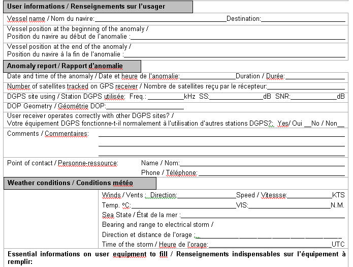
| DGPS station anomaly report / Rapport d'anomalie des stations DGPS |
|
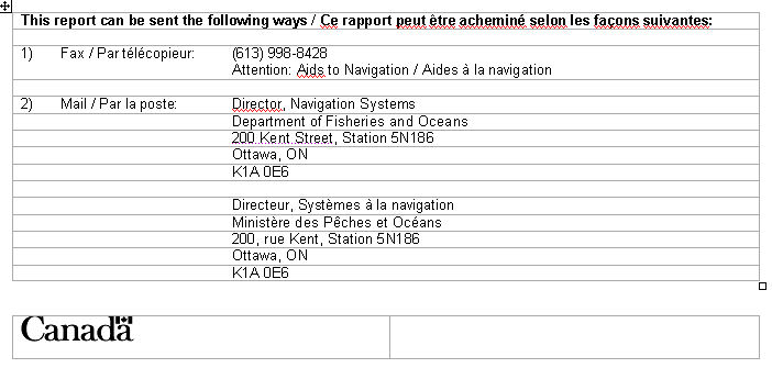
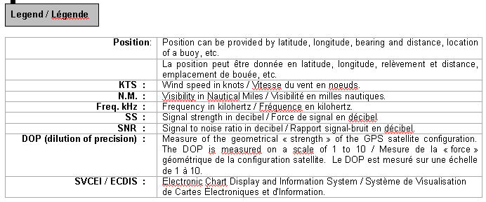
With the purpose of constantly evaluating the quality of the DGPS service offered, the Canadian Coast Guard is providing the mariner with the following anomaly report. This report will allow us to get well-supported information concerning the anomaly and thus, will facilitate the identification of the origin of the problem. Please fill accordingly each section of this report and forward it by the suggested ways. You will find a legend at the end of this document. |
Avec le souci d'évaluer constamment la qualité du service DGPS offert, la Garde côtière met à la disposition du navigateur le présent rapport d'anomalie. Ce rapport servira à bien documenter l'anomalie et, de ce fait, facilitera l'identification ou la recherche de la source du problème. Nous vous prions de bien remplir chaque section de ce rapport et de l'acheminer de la façon suggérée. Vous trouverez une légende à la fin de ce document.

|
MONTHLY EDITION OF NOTICES TO MARINERS |
MAILING LIST CHANGES |
|
|
|
Telephone (613) 990-303 Facsimile (613) 998-8428 |
|
Internet www.notmar.gc.ca |
|
Please indicate which edition you would like to receive. |
|
EASTERN EDITION (Comprised of Arctic, Newfoundland, Maritimes, Gulf & River St. Lawrence and Central areas) ________ |
|
WESTERN EDITION (Comprised of Arctic and Pacific areas)________ |
|
|

INDEX
CANADIAN HYDROGRAPHIC SERVICE - ANNOUNCEMENT REGARDING CANADIAN HYDROGRAPHIC SERVICE CHART PATCHES.... 1
CANADIAN HYDROGRAPHIC SERVICE - ANNOUNCEMENT REGARDING THE NORTH ATLANTIC RIGHT WHALE INFORMATION.... 2
CANADIAN HYDROGRAPHIC SERVICE - ARCTIC CHARTS.... 2
CANADIAN HYDROGRAPHIC SERVICE - CUMULATIVE CHART CORRECTIONS.... 1
CANADIAN HYDROGRAPHIC SERVICE - CURRENT CHART EDITION DATES.... 1
CANADIAN HYDROGRAPHIC SERVICE - PRINT ON DEMAND CHARTS - CARE AND USE.... 1
*704 CANADIAN COAST GUARD - LIST OF CHARTS AND REFERENCE CHARTS (SECTION I) AFFECTED BY TEMPORARY AND PRELIMINARY NOTICES.... 6
*701 CANADIAN HYDROGRAPHIC SERVICE - ELECTRONIC NAVIGATION CHARTS.... 3
*700 CANADIAN HYDROGRAPHIC SERVICE - NAUTICAL CHARTS.... 2
*703 CANADIAN HYDROGRAPHIC SERVICE - NON EQUIVALENT ELECTRONIC NAVIGATION CHARTS.... 5
*702 CANADIAN HYDROGRAPHIC SERVICE - RASTER NAVIGATION CHARTS.... 3
*708 CARDIGAN BAY - MONTAGUE RIVER - LIGHT BUOY PERMANENTLY ESTABLISHED.... 9
*706 COUNTRY ISLAND TO/À BARREN ISLAND - INFORMATION ABOUT BUOY.... 8
*710 HARBOURS ON THE NORTH SHORE/HAVRES SUR LA CÔTE NORD - SAVAGE HARBOUR - LIGHT BUOYS PERMANENTLY REPOSITIONED - LIGHT BUOY PERMANENTLY ESTABLISHED.... 9
*709 HARBOURS ON THE NORTH SHORE/HAVRES SUR LA CÔTE NORD - ST. PETERS HARBOUR - LIGHT BUOYS PERMANENTLY ESTABLISHED.... 9
*711 MALPEQUE BAY - DARNLEY BASIN - LIGHT SPAR BUOY PERMANENTLY REPLACED.... 9
*712 SAINT JOHN HARBOUR AND APPROACHES/ET LES APPROCHES - NAVY ISLAND - LIGHT BUOY PERMANENTLY REPLACED.... 10
*719 ST. LAWRENCE RIVER - CHENAL DE L'ÎLE D'ORLÉANS - BUOY PERMANENTLY DISCONTINUED.... 10
*707(P) ST. PETERS BAY - LIGHT TO BE DISCONTINUED.... 8
*713 SYDNEY HARBOUR - SYDNEY RIVER - BUOY PERMANENTLY DISCONTINUED.... 10
*705 TRANSPORT CANADA PUBLICATIONS - SHIP SAFETY BULLETINS (TP 3231) - 2007.... 7
NUMERICAL INDEX OF CANADIAN CHARTS AFFECTED |
|||||
Chart No. |
Page |
Chart No. |
Page |
Chart No. |
Page |
1236 |
11 |
4237 |
18 |
||
1310 |
11 |
L/C 4320 |
18 |
||
1317 |
11 |
4321 |
18 |
||
1432 |
11 |
4340 |
18 |
||
1433 |
12 |
4367 |
18 |
||
1438 |
2 |
4404 |
19 |
||
2067 |
2 |
4452 |
19 |
||
2165 |
2 |
4469 |
19 |
||
2181 |
2 |
4474 |
19 |
||
L/C 2228 |
12 |
4483 |
19 |
||
4001 |
13 |
4843 |
19 |
||
L/C 4002 |
13 |
4905 |
19 |
||
4003 |
13,14 |
4921 |
20 |
||
4012 |
14 |
6212 |
20 |
||
4013 |
14,15 |
6218 |
20 |
||
4015 |
15 |
8007 |
20 |
||
4021 |
15 |
8012 |
20,21 |
||
4022 |
15 |
8048 |
21 |
||
4045 |
15 |
||||
L/C 4116 |
15 |
||||
4117 |
15,16 |
||||
4202 |
17 |
||||
L/C 4227 |
17 |
||||
4233 |
17 |
||||
4234 |
17,18 |
||||
SECTION 1 – Edition 07/2007
SAFETY AND GENERAL INFORMATION
CANADIAN HYDROGRAPHIC SERVICE - ANNOUNCEMENT REGARDING CANADIAN HYDROGRAPHIC SERVICE CHART PATCHES.
CHS is introducing a new initiative with a full colour Patch on the Web. A link in the Notices to Mariners web site will be provided so clients can access the colour Patch. The colour Patch will be published in HTML and PDF format. Providing the Patches in colour (accessible to all via remote access to the Web) is an enhanced form of alternative service delivery in line with CHS strategic objectives.
Colour Web Patches are free to the mariner, and given the quality of many printers, should reproduce well. They will be available in real time all around the world which is an improvement since clients had to wait for the paper copy to be mailed.
Previously, in the Notices to Mariners (NTM) booklet, Patches were produced in full colour or a minimum of black and magenta.
Due to current budgetary constraints, Patches will now only be produced in black and white for publication in the NTM booklet.
Our level of service will change with this initiative and CHS intends to analyze market reaction to this innovation.
CHS welcomes your feedback on this new service at chsinfo@dfo-mpo.gc.ca
CANADIAN HYDROGRAPHIC SERVICE - CUMULATIVE CHART CORRECTIONS.
The cumulative Notice to Mariners corrections for charts can now be accessed at http://www.notmar.gc.ca/search/notmar-eng.php
CANADIAN HYDROGRAPHIC SERVICE - CURRENT CHART EDITION DATES.
|
CHART EDITIONS |
|
The three terms described below are used to indicate the publication status of Canadian charts. |
|
NEW CHART - "NEWCHT" |
|
The first publication of a Canadian chart embracing an area not previously charted to the scale shown, or embracing an area different from any existing Canadian chart. |
|
NEW EDITION - "NEWEDT" |
|
A new issue of an existing chart containing amendments essential to navigation in addition to those issued in Notice to Mariners and making existing editions obsolete. |
|
REPRINTS |
|
A new issue of the current edition of a chart incorporating no amendments of navigational significance other than those previously promulgated in Notice to Mariners. It may also contain amendments from other sources provided they are not essential to navigation. Previous printings of the current edition remain in force. |
The current chart edition dates can now be accessed at http://www.chs-shc.gc.ca/pub/en/products/core.cfm
CANADIAN HYDROGRAPHIC SERVICE - PRINT ON DEMAND CHARTS - CARE AND USE.
|
Background By providing nautical charts to the public, the goal of the Canadian Hydrographic Service (CHS) is to provide services for safe navigation in a fiscally responsible manner. As a result, CHS continues to expand its portfolio of nautical paper charts that are printed using Print On Demand (POD) technology. These charts are easily recognized by their whiter paper and the coloured logo of the Canadian Hydrographic Service. This new technology enables CHS to print charts in a more efficient manner while enhancing chart content through being able to quickly add new and important information. POD technology provides customers with up-to-date charts without the historical hand-drawn corrections or glued-on patches. Additionally, this technology eliminates out-of-stock situations which arise with the traditional printing and warehousing methods. In the event of a national emergency, CHS can respond to the appropriate authorities with best available information very quickly. Care of Your POD Chart CHS encourages its customers to handle the POD charts more carefully than the traditional lithographic charts. When plotting information on POD charts, use HB pencils and apply limited pressure. Testing has suggested that an Indian gum eraser is more effective than alternatives when used on the product. This eraser is also suitable for charts printed using lithographic processes. |
CANADIAN HYDROGRAPHIC SERVICE - ARCTIC CHARTS.
Please be advised that effective February 2007 all Arctic notices will appear in both the Eastern and Western paper editions of Notices to Mariners.
Mariners may obtain all Arctic chart notices via the Canadian Coast Guard Notices to Mariners online service www.notmar.gc.ca or by contacting the Canadian Coast Guard, Notices to Mariners office at the following coordinates:
Leader, Notices to Mariners
Aids to Navigation
Navigation Systems
Canadian Coast Guard
200 Kent Street, Station 5N186
Ottawa, ON
K1A 0E6
Telephone (613) 993-6974
Facsimile (613) 998-8428
CANADIAN HYDROGRAPHIC SERVICE - ANNOUNCEMENT REGARDING THE NORTH ATLANTIC RIGHT WHALE INFORMATION.
The North Atlantic Right Whale information will no longer be displayed on the back of subsequent printings of charts 4011 and 4012. To obtain this information refer to "Canadian Right Whale Conservation Areas" located in the appendices of Sailing Directions-Gulf of Maine and Bay of Fundy, ATL 106.
CANADIAN COAST GUARD - MARINE COMMUNICATION AND TRAFFIC SERVICES (MCTS).
Marine Communications and Traffic Services will no longer provide the radiotelegram service subject to full international charges after December 31st, 2007. However, messages addressed to "Quarantine" and messages requesting a doctor to meet a ship on arrival will now be handled without charge. MCTS will continue to provide a Marine Telephone Call Service subject to full international charges in selected areas, based upon demand and the availability of alternate service delivery methods.
*700 CANADIAN HYDROGRAPHIC SERVICE - NAUTICAL CHARTS.
|
CHARTS |
MAIN TITLE |
SCALE |
PUBLISHED |
CAT# |
PRICE |
|
New Editions |
All temporary and preliminary notices affecting the previous versions of the following chart(s) (is / are) now cancelled. For any outstanding notices please consult section 2 of this edition. | ||||
|
1438 |
Grindstone Island to/à Carleton Island |
1:25000 |
20-APR-2007 |
3 |
$20.00 |
|
2067 |
Hamilton Harbour |
1:10000 |
15-JUN-2007 |
3 |
$20.00 |
|
2181 |
Harbours in Lake Erie / Havres dans le lac Érié |
---- |
11-MAY-2007 |
3 |
$20.00 |
|
|
|
|
|
|
|
|
Chart Permanently Withdrawn |
|
|
|
|
|
|
2165 |
Wheatley Harbour |
|
|
|
|
*701 CANADIAN HYDROGRAPHIC SERVICE - ELECTRONIC NAVIGATION CHARTS.
|
RELEASED PRODUCTS |
|
|
S-57 ENC NUMBER |
CHART TITLE |
|
CA573308 |
Rose Island to Parry Sound |
|
CA573310 |
Rose Island Channel |
|
CA573360 |
Falconbridge Wharf |
|
CA570138 |
Esquimalt Harbour |
|
CA573283 |
Approaches to / Approches à Parry Sound North |
|
CA573284 |
Approaches to / Approches à Parry Sound |
|
CA276090 |
Sable Island Bank/Banc de l'Île de Sable to/au St.Pierre Bank/Banc de Saint Pierre |
|
CA376135 |
Cape Pine to/au Cape St Mary's |
|
CA276204 |
Halifax to/à Sydney |
|
CA276271 |
Cabot Strait and Approaches, Scatarie Island to Anticosti Island |
|
CA276284 |
Sydney to Saint-Pierre |
|
CA479020 |
Québec à/to Donnacona |
|
CA579049 |
Quai public/Public Wharf |
|
CA179172 |
Golfe du Saint-Laurent / Gulf of St. Lawrence |
*702 CANADIAN HYDROGRAPHIC SERVICE - RASTER NAVIGATION CHARTS.
|
CHARTS |
MAIN TITLE | ||||
|
New Charts |
All temporary and preliminary notices affecting the previous versions of the following chart(s) (is / are) now cancelled. For any outstanding notices please consult section 2 of this edition. | ||||
|
R/M1431 |
Canal de Beauharnois |
|
17-JAN-2003 |
|
See Note 2 |
|
R/M1514 |
Carillon à/to Papineauville |
|
24-JUL-1998 |
|
See Note 2 |
|
New Editions |
All temporary and preliminary notices affecting the previous versions of the following chart(s) (is / are) now cancelled. For any outstanding notices please consult section 2 of this edition. | ||||
|
R/M1310 |
Port de Montréal |
|
26-NOV-2004 |
|
See Note 2 |
|
R/M1409 |
Canal de la Rivière Sud |
|
12-APR-2002 |
|
See Note 2 |
|
R/M1410 |
Lac Saint-Louis |
|
26-APR-2002 |
|
See Note 2 |
|
R/M1438 |
Grindstone Island to/à Carleton Island |
|
20-APR-2007 |
|
See Note 2 |
|
R/M1509A |
Rivière des Prairies |
|
30-DEC-2005 |
|
See Note 2 |
|
R/M1509A |
Île Bizard à/to Pont Viau |
|
30-DEC-2005 |
|
See Note 2 |
|
R/M1509B |
Rivière des Prairies |
|
30-DEC-2005 |
|
See Note 2 |
|
R/M1509B |
Pont Viau à/to Île Bourdon |
|
30-DEC-2005 |
|
See Note 2 |
|
R/M1510A |
Lac Saint-Louis à/to Carillon - Compartment B-C |
|
25-JUL-2003 |
|
See Note 2 |
|
R/M1510A |
Lac des Deux Montagnes |
|
25-JUL-2003 |
|
See Note 2 |
|
R/M1510B |
Lac des Deux Montagnes |
|
25-JUL-2003 |
|
See Note 2 |
|
R/M1510B |
Baie de Vaudreuil à/to Laval - Compartment A-B |
|
25-JUL-2003 |
|
See Note 2 |
|
R/M1512A |
Ottawa to/à Long Island |
|
04-MAR-2005 |
|
See Note 2 |
|
R/M1512B |
Long Island to/à Becketts Landing |
|
04-MAR-2005 |
|
See Note 2 |
|
R/M1512C |
Becketts Landing to/à Smith Falls |
|
04-MAR-2005 |
|
See Note 2 |
|
R/M1512D |
Ottawa to/à Smiths Falls - Cover Notes |
|
04-MAR-2005 |
|
See Note 2 |
|
R/M1513A |
Smith Falls to/à Kingston Including/y compris Tay Branch to/à Perth |
|
07-JUN-1996 |
|
See Note 2 |
|
R/M1513A |
Smith Falls to/à Rocky Narrows |
|
07-JUN-1996 |
|
See Note 2 |
|
R/M1513B |
Smith Falls to/à Kingston Including/y compris Tay Branch to/à Perth |
|
07-JUN-1996 |
|
See Note 2 |
|
R/M1513B |
Rocky Narrows to/à Newboro' |
|
07-JUN-1996 |
|
See Note 2 |
|
R/M1513C |
Smith Falls to/à Kingston Including/y compris Tay Branch to/à Perth |
|
07-JUN-1996 |
|
See Note 2 |
|
R/M1513C |
Newboro' to/à Jones Falls |
|
07-JUN-1996 |
|
See Note 2 |
|
R/M1513D |
Smith Falls to/à Kingston Including/y compris Tay Branch to/à Perth |
|
07-JUN-1996 |
|
See Note 2 |
|
R/M1513D |
Jones Falls to/à River Styx |
|
07-JUN-1996 |
|
See Note 2 |
|
R/M1513E |
Smith Falls to/à Kingston Including/y compris Tay Branch to/à Perth |
|
07-JUN-1996 |
|
See Note 2 |
|
R/M1513E |
River Styx to/ à Kingston |
|
07-JUN-1996 |
|
See Note 2 |
|
R/M1515A |
Papineauville à/to Ottawa |
|
24-JUL-1998 |
|
See Note 2 |
|
R/M1515A |
Papineauville à/to Becketts Creek |
|
24-JUL-1998 |
|
See Note 2 |
|
R/M1515B |
Papineauville à/to Ottawa |
|
24-JUL-1998 |
|
See Note 2 |
|
R/M1515B |
Becketts Creek à/to Ottawa |
|
24-JUL-1998 |
|
See Note 2 |
|
R/M1550 |
Britannia Bay à/to Chats Falls |
|
26-DEC-2003 |
|
See Note 2 |
|
R/M1551 |
Chats Falls à/to Chenaux |
|
24-AUG-2001 |
|
See Note 2 |
|
R/M1552A |
Portage-du-Fort to/à L' Île Fraser |
|
05-JUN-1998 |
|
See Note 2 |
|
R/M1552A |
Portage-du-Fort to/à Chute du Grand Calumet including/y compris chenal du Rocher Fendu |
|
05-JUN-1998 |
|
See Note 2 |
|
R/M1552B |
Portage-du-Fort to/à L' Île Fraser |
|
05-JUN-1998 |
|
See Note 2 |
|
R/M1552B |
Chute du Grand Calumet to/au Lac Coulonge |
|
05-JUN-1998 |
|
See Note 2 |
|
R/M1552C |
Portage-du-Fort to/à L' Île Fraser |
|
05-JUN-1998 |
|
See Note 2 |
|
R/M1552C |
Lac Coulonge to/à L'Île Fraser including/y compris Le chenal de la Culbute |
|
05-JUN-1998 |
|
See Note 2 |
|
R/M1553A |
Île Marcotte à/to Rapides-des-Joachims |
|
31-MAR-2006 |
|
See Note 2 |
|
R/M1553A |
Île Marcotte à/to Île D'Arcy |
|
31-MAR-2006 |
|
See Note 2 |
|
R/M1553B |
Île Marcotte à/to Rapides-des-Joachims |
|
31-MAR-2006 |
|
See Note 2 |
|
R/M1553B |
Île D'Arcy à/to Balmer Bay |
|
31-MAR-2006 |
|
See Note 2 |
|
R/M1553C |
Île Marcotte à/to Rapides-des-Joachims |
|
31-MAR-2006 |
|
See Note 2 |
|
R/M1553C |
Balmer Bay à/to Rapides-des-Joachims |
|
31-MAR-2006 |
|
See Note 2 |
|
R/M1554A |
Rapides-des-Joachims au/to Lac la Cave |
|
16-JUN-2006 |
|
See Note 2 |
|
R/M1554A |
Rapides-des-Joachims au/to Maraboo Lake |
|
16-JUN-2006 |
|
See Note 2 |
|
R/M1554B |
Rapides-des-Joachims au/to Lac la Cave |
|
16-JUN-2006 |
|
See Note 2 |
|
R/M1554B |
Maraboo Lake à/to Bald Rock |
|
16-JUN-2006 |
|
See Note 2 |
|
R/M1554C |
Rapides-des-Joachims au/to Lac la Cave |
|
16-JUN-2006 |
|
See Note 2 |
|
R/M1554C |
Bald Rock au/to Lac la Cave |
|
16-JUN-2006 |
|
See Note 2 |
|
R/M1555 |
Lac la Cave |
|
25-MAY-2001 |
|
See Note 2 |
|
R/M1556A |
Lac Temiscamingue/ Lake Timiskaming |
|
02-APR-2004 |
|
See Note 2 |
|
R/M1556A |
Lac Temiscamingue/ Lake Timiskaming |
|
02-APR-2004 |
|
See Note 2 |
|
R/M1556B |
Lac Temiscamingue/ Lake Timiskaming |
|
02-APR-2004 |
|
See Note 2 |
|
R/M1556B |
|
|
02-APR-2004 |
|
See Note 2 |
|
R/M2067 |
Hamilton Harbour |
|
15-JUN-2007 |
|
See Note 2 |
|
|
|
|
|
|
|
|
Charts Permanently Withdrawn |
|
|
|
|
|
|
R/M1513 |
Smith Falls to/à Kingston Including/y compris Tay Branch to/à Perth |
|
|
|
|
|
R/M1515 |
Papineauville à/to Ottawa |
|
|
|
|
|
R/M1556 |
Lac Temiscamingue/ Lake Timiskaming |
|
|
|
|
|
R/M2165 |
Wheatley Harbour |
|
|
|
|
|
R/M3476 |
Approaches to/Approches à Tsehum Harbour |
|
|
|
|
|
R/M1509 |
Rivière des Prairies |
|
|
|
|
|
R/M1510 |
Lac des Deux Montagnes |
|
|
|
|
|
R/M1512 |
Ottawa to/à Smiths Falls |
|
|
|
|
|
R/M1552 |
Portage-du-Fort to/à L' Île Fraser |
|
|
|
|
|
R/M1553 |
Île Marcotte à/to Rapides-des-Joachims |
|
|
|
|
|
R/M1554 |
Rapides-des-Joachims au/to Lac la Cave |
|
|
|
|
*703 CANADIAN HYDROGRAPHIC SERVICE - NON EQUIVALENT ELECTRONIC NAVIGATION CHARTS.
|
Note: |
The following ENC products are not equivalent to the current editions of their corresponding paper charts and should not be used as a replacement.
| |
|
NON EQUIVALENT PRODUCTS | ||
|
S-57 ENC NUMBER |
PAPER CHART NUMBER |
CHART TITLE |
|
CA176290 |
5001 |
Labrador Sea/Mer du Labrador |
|
CA276286 |
4023 |
Northhumberland Strait / Détroit de Northumberland |
|
CA276477 |
8013 |
Flemish Cap/Bonnet Flamand |
|
CA373067 |
2304 |
Oiseau Bay to/à Jackfish Bay |
|
CA376014 |
4242 |
Cape Sable Island to/aux Tusket Islands |
|
CA376045 |
4240 |
Liverpool Harbour to/à Lockeport Harbour |
|
CA376047 |
4241 |
Lockeport to/à Cape Sable |
|
CA376093 |
4367 |
Flint Island to/à Cape Smoky |
|
CA376094 |
4020 |
Strait of Belle Isle/Détroit de Belle Isle |
|
CA376212 |
5143 |
Lake Melville |
|
CA476179 |
4466 |
Hillsborough Bay |
|
CA476202 |
4211 |
Cape Lahave to/à Liverpool Bay |
|
CA476327 |
4596 |
Bay of Exploits Sheet/feuille II (Middle/centre) |
|
CA476328 |
4597 |
Bay of Exploits Sheet/feuille III (South/sud) |
|
CA576226 |
4587 |
Fishery Products International Wharves / Quais |
*704CANADIAN COAST GUARD - LIST OF CHARTS AND REFERENCE CHARTS (SECTION I) AFFECTED BY TEMPORARY AND PRELIMINARY NOTICES.
|
IN EFFECT JULY 27, 2007 (REVISED AND PROMULGATED QUARTERLY) | |
|
1220 |
28-MAY(T)/04 |
|
1314 |
607(P)/06 |
|
1315 |
607(P)/06 |
|
1317 |
210(P)/07 |
|
1351 |
196(T)/87, 636(P)/93, 510(P)/98, 517(P)/98 |
|
1361 |
1101(P)/99 |
|
1409 |
1205(T)/06, 311(T)/07 |
|
1410 |
1206(T)/06, 211(P)/07 |
|
1434 |
03-AUG(P)/01 |
|
1509 |
517(P)/98, 506(T)/07 |
|
1510 |
517(P)/98, 507(T)/07 |
|
1511 |
517(P)/98 |
|
2024 |
103(P)/06 |
|
2028 |
103(P)/06 |
|
2181 |
725(T)/91, 03-AUG(P)/01 |
|
2218 |
28-APR(P)/00 |
|
2241 |
28-APR(P)/00 |
|
2250 |
361(P)/97 |
|
2260 |
106(P)/06 |
|
2283 |
31-MAR(P)/00, 04-JAN(P)/02, 1207(P)/06 |
|
LC 3000 |
2346(P)/99, 28-APR(P)/00, 03-NOV(P)/00, 23-MAR(P)/01 |
|
3053 |
19-JAN(P)/01 |
|
3313 |
30-MAY(P)/03 |
|
3424 |
511(P)/07 |
|
3440 |
509(P)/07 |
|
3441 |
612(P)/07 |
|
3458 |
14-FEB(P)/03 |
|
3476 |
30-MAY(P)/03, 510(P)/07, 613(P)/07 |
|
3495 |
508(P)/07 |
|
3534 |
611(P)/07 |
|
3538 |
1101(P)/06 |
|
3601 |
907(P)/06 |
|
3602 |
907(P)/06 |
|
LC 3604 |
23-MAR(P)/01 |
|
3606 |
907(P)06 |
|
3802 |
1103(T)/06 |
|
3891 |
24-AUG(P)/01 |
|
3955 |
15-SEP(P)/00 |
|
3958 |
615(P)/07 |
|
4000 |
21-APR(T)/06 |
|
4001 |
17-SEP(T)/04, 21-APR(T)/06, 01-DEC(T)/06 |
|
4003 |
21-APR(T)/06, 01-DEC(T)/06 |
|
4006 |
21-APR(T)/06, 01-DEC(T)/06 |
|
4023 |
208(P)/07 |
|
4098 |
1102(P)/03 |
|
4142 |
904(P)/06 |
|
4203 |
309(T)/07 |
|
4210 |
607(P)/04, 610(P)/04, 11-AUG(T)/06 |
|
LC 4230 |
11-AUG(T)/06 |
|
4234 |
306(P)/07 |
|
4240 |
405(P)/05 |
|
4241 |
1114(P)/04, 11-AUG(T)/06 |
|
LC 4242 |
11-AUG(T)/06 |
|
4244 |
601(P)/06 |
|
4245 |
106(P)/07 |
|
4266 |
308(P)/07, 411(P)/07, 504(P)/07 |
|
4385 |
902(P)/04 |
|
4404 |
01-JUL(T)/05 |
|
4405 |
24-MAR(T)/06 |
|
4416 |
26-APR(T)/02, 15-NOV(T)/02, 29-NOV(T)/02, 25-FEB(T)/05 |
|
4425 |
207(P)/07, 307(P)/07 |
|
4428 |
908(P)/05 |
|
4437 |
01-JUL(T)/05, 505(P)/07 |
|
4448 |
209(P)/07 |
|
4454 |
908(P)/05 |
|
4466 |
24-MAR(T)/06 |
|
4467 |
1007(P)/06 |
|
4483 |
610(P)/07 |
|
4486 |
04-JAN(T)/02, 24-JAN(T)/03, 16-MAY(T)/03, 31-OCT(T)/03, 107(P)/07 |
|
4492 |
1208(P)/06 |
|
4615 |
15-DEC(T)/06 |
|
4619 |
15-DEC(T)/06 |
|
4839 |
15-DEC(T)/06 |
|
4885 |
22-JUN(P)/07 |
|
4954 |
16-MAY(T)/03, 18-JUL(T)/03, 17-DEC(T)/04 |
|
5449 |
808(P)/04 |
|
5707 |
807(P)/04 |
|
6251 |
23-JUN(P)/00 |
|
6267 |
112(P)/06 |
|
7010 |
153(T)/99 |
|
LC 7011 |
153(T)/99 |
|
7083 |
847(P)/89, 1510(P)/98, 1727(P)/98 |
|
7371 |
634(P)/96 |
|
7760 |
1510(P)/98, 1727(P)/98 |
|
8006 |
21-APR(T)/06 |
|
8007 |
01-DEC(T)/06 |
|
8012 |
17-SEP(T)/04 |
|
8015 |
26-APR(T)/02 |
*705 TRANSPORT CANADA PUBLICATIONS - SHIP SAFETY BULLETINS (TP 3231) - 2007.
|
Ship Safety Bulletins address safety-related matters pertaining to vessels. Bulletins are available from Transport Canada's Marine Safety Directorate free of charge and are issued on an "as needed" basis. |
|
A complete list of Ship Safety Bulletins are available on Transport Canada's Web site. |
|
If you do not have access to our Web site and wish to be included in the Ship Safety Bulletins mailing list, please send your request to the Marine Safety location provided below. |
|
As of June 30, 2007, the following bulletins have been issued. |
|
Bulletin Number |
Title |
Date of Creation |
|
01/2007 |
Marine Emergency Duties Training for Personnel on Small Fishing and Small Commercial Vessels |
2007-03-27 |
Transport Publications (TPs) New and/or Amended - 2007
|
Publication No |
Title |
Date |
|
TP 4957 |
Marine Emergency Duties Training Program |
June 2007 |
|
TP 8129 |
Tanker Safety, Crude Oil Washing and Inert Gas, and Supervisor of Transfer Operations Training Courses |
March 2007 |
|
Publication No |
Title |
Date |
|
TP 10933 |
Engine Room Rating Training Program |
June 2007 |
|
TP 10937 |
Mobile Offshore Units (MOUS) Training Courses |
January 2007 |
|
TP 11130 |
Training Course In Marine Cooking |
June 2007 |
|
TP 12301 |
Standard for 5 ppm Bilge Alarms
|
January 2007 |
|
TP 13024 |
Training Standards for RO-RO passenger ships personnel |
July 2007 |
|
TP 13813 |
CANADA SHIPPING ACT, 2001
|
May 2007 |
|
TP 14609 |
Study Guide for Applicants to the Fourth-class Engineer Certificate with STCW Endorsement |
June 2007 |
|
TP 14658 |
Registration of non-pleasure craft (small commercial vessels) in the "Small Vessel Register" - New requirements under the Canada Shipping Act 2001 (CSA 2001) |
April 2007 |
|
TP 14673 |
Safety Stickers |
March 2007 |
|
TP 14674 |
Boating Safety Brochure |
March 2007 |
|
TP 14675 |
Boating Safety - Right of Way Diagram |
March 2007 |
|
TP 10655 |
Approved Training Courses |
June 2007 |
|
Copies of these publications may be obtained from: |
|
Marine Safety
|
|
E-mail: marinesafety@tc.gc.ca |
|
Web site: Ship Safety Bulletins: http://www.tc.gc.ca/marinesafety/bulletins/toc_e.htm |
|
Transport Publications: http://www.tc.gc.ca/MarineSafety/TP/menu.htm |
|
Phone: (613) 991-3135 |
|
Fax: (613) 990-1879 |
*706 COUNTRY ISLAND TO/À BARREN ISLAND - INFORMATION ABOUT BUOY.
|
Reference Notice 609/2007. Reference chart: 4234 Green port spar buoy TY5 remains in position (45° 05' 11" N 61° 38' 32.5" W) (G2007-071) |
*707(P) ST. PETERS BAY - LIGHT TO BE DISCONTINUED.
|
Reference chart: 4275 The Canadian Coast Guard intends to permanently discontinue the following aid to navigation: Cape Ronde light LL 728 (45° 34' 39" N 60° 53' 22.3" W) Comments on this action are solicited from mariners and other interested parties. Comments should be directed to Glen Graham, Superintendent, Aids to Navigation, Canadian Coast Guard, P.O. Box 1000, Dartmouth, NS., B2Y 3Z8, E-mail: GrahamG@mar.dfo-mpo.gc.ca , within three months from the date of this notice. Any objections raised must state the facts on which they are based and should include supporting information on safety, commerce and public benefit. (G2007-114) |
*708 CARDIGAN BAY - MONTAGUE RIVER - LIGHT BUOY PERMANENTLY ESTABLISHED.
|
Reference chart: 4422 Green light spar buoy, "Fl G" marked "NH7" LL 957.41 has been permanently established in 46° 10' 16.2" N 62° 36' 57.6" W. (G2007-085) |
*709 HARBOURS ON THE NORTH SHORE/HAVRES SUR LA CÔTE NORD - ST. PETERS HARBOUR - LIGHTBUOYS PERMANENTLY ESTABLISHED.
|
Reference chart: 4425 Green light buoy, "Fl G" marked "JD5" LL 1044.1 has been permanently established in 46° 27' 00.2" N 62° 44' 10.6" W. Red light buoy, "Fl R" marked "JD6" LL 1044.2 has been permanently established in 46° 26' 58.2" N 62° 44' 24.6" W. Red light buoy, "Fl R" marked "JD8" LL 1044.3 has been permanently established in 46° 26' 51.7" N 62° 44' 18.6" W. Green light spar buoy "Fl G" marked "JD9" LL 1044.4 has been permanently established in 46° 26' 48.2" N 62° 44' 17.6" W. Red light spar buoy "Fl R" marked "JD10" LL 1044.5 has been permanently established in 46° 26' 45.2" N 62° 44' 18.6" W. (G2007-074, 075, 079, 080, 081) |
*710 HARBOURS ON THE NORTH SHORE/HAVRES SUR LA CÔTE NORD - SAVAGE HARBOUR - LIGHT BUOYSPERMANENTLY REPOSITIONED - LIGHT BUOY PERMANENTLY ESTABLISHED.
|
Reference chart: 4425 Red starboard lighted pillar buoy "Fl R" marked "JE8" LL 1047.02 has been permanently repositioned to 46° 25' 58.4" N 62° 49' 58.9" W. Red starboard light pillar buoy "Q R" marked "JE8/2" LL 1047.021 has been permanently established in 46° 25' 47.4" N 62° 50' 01.4" W. Red starboard lighted pillar buoy "Q R" marked "JE10" LL 1047.03 has been permanently repositioned to 46° 25' 46.1" N 62° 50' 03.3" W. (G2007-107, 108, 109) |
*711 MALPEQUE BAY - DARNLEY BASIN - LIGHT SPAR BUOY PERMANENTLY REPLACED.
|
Reference chart: 4491 Red light spar buoy JU8 has been permanently replaced by a red pillar light buoy "Q R", marked "JU8" LL 1069.8 (46° 33' 19.2" N 63° 41' 42.7" W). (G2007-096) |
*712 SAINT JOHN HARBOUR AND APPROACHES/ET LES APPROCHES - NAVY ISLAND - LIGHT BUOYPERMANENTLY REPLACED.
|
Reference chart: 4117 Green port lighted can buoy J19 (L.L. 102.19) ( 45° 16' 08.8" N 66° 04' 23" W) has been permanently replaced by a green port lighted pillar buoy, marked "J19". (F2007-073) |
*713 SYDNEY HARBOUR - SYDNEY RIVER - BUOY PERMANENTLY DISCONTINUED.
|
Reference chart: 4266 Yellow cautionary spar buoy, marked "PLASORT1" (46° 08' 10" N 60° 11' 53" W) has been permanently discontinued. (G2007-092) |
*719 ST. LAWRENCE RIVER - CHENAL DE L'ÎLE D'ORLÉANS - BUOY PERMANENTLY DISCONTINUED.
|
Reference: Notice 210(P)/07 is cancelled. (Q2007-057) |
SECTION 2 – Edition 07/2007
CHART CORRECTIONS
1236 - Pointe des Monts aux/to Escoumins - New Edition - 23-JUL-2004 - NAD 1983
|
06-JUL-2007 |
LNM/D. 25-MAY-2007 |
|
|
Delete |
note Carte/Chart 1260 |
48°38'40.0"N 068°12'30.0"W |
|
DFO(6407427-01) | ||
|
Add |
note |
48°38'40.0"N 068°12'30.0"W |
|
DIAGRAMME/Voir Instructions nautiques
| ||
|
DFO(6407427-02) | ||
1310 - Section B-C - New Edition - 26-NOV-2004 - NAD 1983
|
06-JUL-2007 |
LNM/D. 25-MAY-2007 |
|
|
Delete |
green port hand lighted pillar buoy Fl G, marked MT67 |
45°34'19.2"N 073°29'54.0"W |
|
(Q2007041) LL(2365.81) DFO(6407475-01) | ||
|
Delete |
green port hand lighted pillar buoy Fl G, marked MT69 |
45°34'06.5"N 073°30'11.6"W |
|
(Q2007044) LL(2365.83) DFO(6407477-01) | ||
|
Add |
red starboard hand lighted pillar buoy Fl R, marked MT68 |
45°34'29.8"N 073°29'36.5"W |
|
(Q2007042) LL(2365.82) DFO(6407476-01) | ||
|
Add |
green port hand lighted pillar buoy Fl G, marked MT69 |
45°34'13.9"N 073°30'04.3"W |
|
(Q2007044) LL(2365.83) DFO(6407477-02) | ||
|
Add |
starboard hand daybeacon |
45°30'29.2"N 073°31'53.4"W |
|
(Q2007050) DFO(6407480-01) | ||
|
Add |
port hand daybeacon |
45°30'28.8"N 073°31'51.3"W |
|
(Q2007051) DFO(6407481-01) | ||
|
Add |
starboard hand daybeacon |
45°30'30.2"N 073°31'53.1"W |
|
(Q2007052) DFO(6407482-01) | ||
|
Add |
port hand daybeacon |
45°30'30.0"N 073°31'51.0"W |
|
(Q2007053) DFO(6407483-01) | ||
1317 - Sault-au-Cochon à/to Québec - New Edition - 17-AUG-2001 - NAD 1983
|
27-JUL-2007 |
LNM/D. 13-APR-2007 |
|
|
Delete |
red starboard hand conical buoy, marked V2 |
47°04'23.1"N 070°44'52.3"W |
|
(Q2007057) DFO(6407486-01) | ||
1432 - Lac Saint-François/Lake St. Francis A-B - New Chart - 09-JUL-1999 - NAD 1983
|
20-JUL-2007 |
LNM/D. 29-JUN-2007 |
|
|
Add |
private orange and white mooring spherical buoy, marked 1
|
45°08'44.9"N 074°22'07.1"W |
|
(B2007025) DFO(6602972-01) | ||
|
Add |
private orange and white mooring spherical buoy, marked 2
|
45°08'41.2"N 074°22'17.8"W |
|
(B2007026) DFO(6602973-01) | ||
1433 - Île St-Régis to/à Croil Islands A- B - New Chart - 28-MAY-1999 - NAD 1983
|
06-JUL-2007 |
LNM/D. 29-JUN-2007 |
|
|
Delete |
red starboard hand conical buoy, marked 18
|
44°59'26.2"N 074°45'51.2"W |
|
(B2007013) DFO(6602959-01) | ||
1433 - Île St-Régis to/à Croil Islands B-C - New Chart - 28-MAY-1999 - NAD 1983
|
06-JUL-2007 |
LNM/D. 29-JUN-2007 |
|
|
Delete |
light FG
|
44°58'43.0"N 074°51'11.2"W |
|
(B2007012) LL(212) DFO(6602958-01) | ||
|
Delete |
red starboard hand conical buoy, marked 32A
|
44°58'52.8"N 074°50'23.9"W |
|
(B2007014) DFO(6602960-01) | ||
|
Delete |
red starboard hand conical buoy, marked 38A
|
44°58'43.4"N 074°51'37.2"W |
|
(B2007015) DFO(6602961-01) | ||
|
27-JUL-2007 |
LNM/D. 06-JUL-2007 |
|
|
Delete |
legend 37 |
44°58'43.0"N 074°51'11.2"W |
|
(B2007012) LL(212) DFO(6602989-01) | ||
L/C2228 - Goderich Harbour - Sheet 2 - New Chart - 16-FEB-1990 - NAD 1983
|
13-JUL-2007 |
LNM/D. 06-JAN-2006 |
|
|
Delete |
green port hand spar buoy, marked VX3
|
43°44'51.7"N 081°43'56.8"W |
|
(D2007005) LL(9004) DFO(6602966-01) | ||
|
Delete |
red starboard hand spar buoy, marked VX4
|
43°44'42.4"N 081°43'50.5"W |
|
(D2007006) LL(9005) DFO(6602967-01) | ||
|
Delete |
green port hand spar buoy, marked VX5
|
43°44'52.1"N 081°43'50.1"W |
|
(D2007007) LL(9006) DFO(6602968-01) | ||
|
Reposition |
green port hand spar buoy, marked VX7
|
from 43°44'52.7"N 081°43'44.5"W |
|
to 43°44'52.6"N 081°43'44.6"W |
||
|
(D2007008) LL(9007) DFO(6602969-01) | ||
|
Add |
green port hand spar buoy, marked VX3
|
43°44'50.4"N 081°44'02.3"W |
|
(D2007005) LL(9004) DFO(6602966-02) | ||
|
Add |
red starboard hand spar buoy, marked VX4
|
43°44'42.1"N 081°43'53.9"W |
|
(D2007006) LL(9005) DFO(6602967-02) | ||
|
Add |
green port hand spar buoy, marked VX5
|
43°44'51.7"N 081°43'51.8"W |
|
(D2007007) LL(9006) DFO(6602968-02) | ||
4001 - Gulf of Maine to Strait of Belle Isle au Détroit de Belle Isle - New Edition - 01-DEC-1995 - NAD 1983
|
06-JUL-2007 |
LNM/D. 23-FEB-2007 |
|
|
CANCELS |
scientific subsurface mooring at a depth of 98 metres below the surface |
48°12'02.5"N 047°53'13.5"W |
|
The mooring has been removed. Notice 17-September-2004(T), DFO (6301824-01) is now cancelled. | ||
|
DFO(6301824-01) | ||
|
CANCELS |
scientific subsurface mooring at a depth of 693 metres below the surface |
48°19'44.3"N 047°48'30.5"W |
|
The mooring has been removed. Notice 17-September-2004(T), DFO (6301824-02) is now cancelled. | ||
|
DFO(6301824-02) | ||
|
CANCELS |
scientific subsurface mooring at a depth of 100 metres below the surface |
48°32'19.8"N 047°41'25.2"W |
|
The mooring has been removed. Notice 17-September-2004(T), DFO (6301824-03) is now cancelled. | ||
|
DFO(6301824-03) | ||
|
CANCELS |
scientific subsurface mooring at a depth of 2219 metres below the surface |
48°49'55.6"N 047°27'15.9"W |
|
The mooring has been removed. Notice 17-September-2004(T), DFO (6301824-04) is now cancelled. | ||
|
DFO(6301824-04) | ||
|
CANCELS |
scientific subsurface mooring at a depth of 100 metres below the surface |
49°17'49.0"N 048°18'58.4"W |
|
The mooring has been removed. Notice 17-September-2004(T), DFO (6301824-05) is now cancelled. | ||
|
DFO(6301824-05) | ||
L/C4002 - Golfe du Saint-Laurent / Gulf of St. Lawrence - New Edition - 27-DEC-1991 - NAD 1927
|
06-JUL-2007 |
LNM/D. 22-JUN-2007 |
|
|
Delete |
wreck WK with known depth of 5 fathoms and legend "(Repd 1934)" |
47°28'23.8"N 061°34'15.6"W |
|
DFO(6407484-01) | ||
4003 - Cape Breton to/à Cape Cod - New Edition - 21-MAR-2003 - NAD 1983
|
06-JUL-2007 |
LNM/D. 22-JUN-2007 |
|
|
(T)Add |
yellow ODAS/SADO lighted super-buoy Fl (5) Y |
44°17'18.0"N 063°14'18.0"W |
|
Proposed date of removal is November 2007 | ||
|
DFO(6303535-01) | ||
|
(T)Add |
yellow ODAS/SADO lighted super-buoy Fl (5) Y |
44°17'46.3"N 063°14'19.0"W |
|
Proposed date of removal is November 2007 | ||
|
DFO(6303535-02) | ||
|
(T)Add |
yellow ODAS/SADO lighted super-buoy Fl (5) Y |
44°17'50.6"N 063°15'41.6"W |
|
Proposed date of removal is November 2007 | ||
|
DFO(6303535-03) | ||
|
(T)Add |
yellow ODAS/SADO lighted super-buoy Fl (5) Y |
44°17'15.7"N 063°14'12.7"W |
|
Proposed date of removal is November 2007 | ||
|
DFO(6303535-04) | ||
|
(T)Add |
subsurface mooring |
44°17'15.6"N 063°14'12.6"W |
|
Proposed date of removal is November 2007 | ||
|
DFO(6303535-05) | ||
|
(T)Add |
subsurface mooring at a depth of 1032 fathoms below the surface |
42°41'16.2"N 061°31'27.1"W |
|
Proposed date of removal is November 2007 | ||
|
DFO(6303537-01) | ||
4012 - Yarmouth to/à Halifax - New Edition - 14-FEB-2003 - NAD 1983
|
06-JUL-2007 |
LNM/D. 09-FEB-2007 |
|
|
(T)Add |
yellow ODAS/SADO lighted super-buoy Fl (5) Y |
44°17'18.0"N 063°14'18.0"W |
|
Proposed date of removal is November 2007 | ||
|
DFO(6303535-01) | ||
|
(T)Add |
yellow ODAS/SADO lighted super-buoy Fl (5) Y |
44°17'46.3"N 063°14'19.0"W |
|
Proposed date of removal is November 2007 | ||
|
DFO(6303535-02) | ||
|
(T)Add |
yellow ODAS/SADO lighted super-buoy Fl (5) Y |
44°17'50.6"N 063°15'41.6"W |
|
Proposed date of removal is November 2007 | ||
|
DFO(6303535-03) | ||
|
(T)Add |
yellow ODAS/SADO lighted super-buoy Fl (5) Y |
44°17'15.7"N 063°14'12.7"W |
|
Proposed date of removal is November 2007 | ||
|
DFO(6303535-04) | ||
|
(T)Add |
subsurface mooring |
44°17'15.6"N 063°14'12.6"W |
|
Proposed date of removal is November 2007 | ||
|
DFO(6303535-05) | ||
4013 - Halifax to/à Sydney - New Edition - 06-SEP-2002 - NAD 1983
|
06-JUL-2007 |
LNM/D. 09-DEC-2005 |
|
|
(T)Add |
yellow ODAS/SADO lighted super-buoy Fl (5) Y |
44°17'18.0"N 063°14'18.0"W |
|
Proposed date of removal is November 2007 | ||
|
DFO(6303535-01) | ||
|
(T)Add |
yellow ODAS/SADO lighted super-buoy Fl (5) Y |
44°17'46.3"N 063°14'19.0"W |
|
Proposed date of removal is November 2007 | ||
|
DFO(6303535-02) | ||
|
(T)Add |
yellow ODAS/SADO lighted super-buoy Fl (5) Y |
44°17'50.6"N 063°15'41.6"W |
|
Proposed date of removal is November 2007 | ||
|
DFO(6303535-03) | ||
|
(T)Add |
yellow ODAS/SADO lighted super-buoy Fl (5) Y |
44°17'15.7"N 063°14'12.7"W |
|
Proposed date of removal is November 2007 | ||
|
DFO(6303535-04) | ||
|
(T)Add |
subsurface mooring |
44°17'15.6"N 063°14'12.6"W |
|
Proposed date for removal is November 2007 | ||
|
DFO(6303535-05) | ||
|
13-JUL-2007 |
LNM/D. 09-DEC-2005 |
|
|
Replace |
red and white fairway pillar whistle buoy Mo(A), WHIS with a red and white fairway lighted pillar buoy Mo(A) |
46°18'24.2"N 060°07'50.6"W |
|
DFO(6303451-02) | ||
4015 - Sydney to/à Saint-Pierre - New Edition - 28-MAR-2003 - NAD 1983
|
13-JUL-2007 |
LNM/D. 17-NOV-2006 |
|
|
Delete |
WHIS against red and white fairway lighted pillar whistle buoy Mo(A) |
46°18'24.2"N 060°07'50.6"W |
|
(G2007037) LL(776) DFO(6303451-01) | ||
4021 - Pointe Amour à/to Cape Whittle et/and Cape George - New Edition - 01-NOV-2002 - NAD 1983
|
06-JUL-2007 |
LNM/D. 01-JUN-2007 |
|
|
Amend |
legend Fl 6s 99ft 14M to read Fl 15s 74ft 13M against light |
50°45'12.4"N 058°45'20.9"W |
|
(Q2007039) LL(1543) DFO(6407472-01) | ||
4022 - Cabot Strait and approaches / Détroit de Cabot et les approches, Scatarie Island to/à Anticosti Island / Île D'Anticosti - New Edition - 17-JAN-2003 - NAD 1983
|
13-JUL-2007 |
LNM/D. 25-MAY-2007 |
|
|
Delete |
WHIS against red and white fairway lighted pillar whistle buoy Mo(A) |
46°18'24.2"N 060°07'50.6"W |
|
(G2007037) LL(776) DFO(6303451-01) | ||
4045 - Sable Island Bank/Banc de I'Île de Sable to/au St. Pierre Bank/Banc de Saint Pierre - New Edition - 10-OCT-2003 - NAD 1983
|
13-JUL-2007 |
LNM/D. 25-NOV-2005 |
|
|
Delete |
WHIS against red and white fairway lighted pillar whistle buoy Mo(A) |
46°18'24.2"N 060°07'50.6"W |
|
(G2007037) LL(776) DFO(6303451-01) | ||
L/C4116 - Approaches to/Approches à Saint John - New Chart - 09-APR-1993 - NAD 1983
|
06-JUL-2007 |
LNM/D. 01-DEC-2006 |
|
|
Delete |
yellow ODAS/SADO lighted super-buoy Fl (5) Y |
45°12'15.6"N 066°01'04.8"W |
|
DFO(6303510-01) | ||
4117 - Saint John Harbour and Approaches/et les approches - New Edition - 12-JUL-2002 - NAD 1983
|
06-JUL-2007 |
LNM/D. 01-DEC-2006 |
|
|
Delete |
yellow ODAS/SADO lighted super-buoy Fl (5) Y |
45°12'15.6"N 066°01'04.8"W |
|
DFO(6303510-01) | ||
|
(T)Add |
private yellow cautionary lighted can buoy Fl Y (15s) |
45°12'43.2"N 065°58'28.3"W |
|
Canaport LNG has commenced its offshore construction of the marine terminal and multi purpose pier project. Proposed completion date is November 2007. | ||
|
DFO(6303515-01) | ||
|
(T)Add |
private yellow cautionary lighted can buoy Fl Y (15s) |
45°12'37.3"N 065°58'17.6"W |
|
Canaport LNG has commenced its offshore construction of the marine terminal and multi purpose pier project. Proposed completion date is November 2007. | ||
|
DFO(6303515-02) | ||
|
(T)Add |
private yellow cautionary lighted can buoy Fl Y (15s) |
45°12'22.3"N 065°58'06.4"W |
|
Canaport LNG has commenced its offshore construction of the marine terminal and multi purpose pier project. Proposed completion date is November 2007. | ||
|
DFO(6303515-03) | ||
|
(T)Add |
private yellow cautionary lighted can buoy Fl Y (15s) |
45°12'11.7"N 065°58'07.8"W |
|
Canaport LNG has commenced its offshore construction of the marine terminal and multi purpose pier project. Proposed completion date is November 2007. | ||
|
DFO(6303515-04) | ||
|
(T)Add |
private yellow cautionary lighted can buoy Fl Y (15s) |
45°11'59.9"N 065°58'19.3"W |
|
Canaport LNG has commenced its offshore construction of the marine terminal and multi purpose pier project. Proposed completion date is November 2007. | ||
|
DFO(6303515-05) | ||
|
(T)Add |
private yellow cautionary lighted can buoy Fl Y (15s) |
45°11'54.1"N 065°58'39.3"W |
|
Canaport LNG has commenced its offshore construction of the marine terminal and multi purpose pier project. Proposed completion date is November 2007. | ||
|
DFO(6303515-06) | ||
|
(T)Add |
private yellow cautionary lighted can buoy Fl Y (15s) |
45°12'05.9"N 065°58'51.1"W |
|
Canaport LNG has commenced its offshore construction of the marine terminal and multi purpose pier project. Proposed completion date is November 2007. | ||
|
DFO(6303515-07) | ||
|
(T)Add |
private yellow cautionary lighted can buoy Fl Y (15s) |
45°12'14.4"N 065°59'19.1"W |
|
Canaport LNG has commenced its offshore construction of the marine terminal and multi purpose pier project. Proposed completion date is November 2007. | ||
|
DFO(6303515-08) | ||
|
(T)Add |
private yellow cautionary lighted can buoy Fl Y (15s) |
45°12'26.1"N 065°59'18.6"W |
|
Canaport LNG has commenced its offshore construction of the marine terminal and multi purpose pier project. Proposed completion date is November 2007. | ||
|
DFO(6303515-09) | ||
|
(T)Add |
private yellow can mooring buoy |
45°12'33.2"N 065°58'25.1"W |
|
Canaport LNG has commenced its offshore construction of the marine terminal and multi purpose pier project. Proposed completion date is November 2007. | ||
|
DFO(6303515-10) | ||
|
(T)Add |
private yellow can mooring buoy |
45°12'25.6"N 065°58'18.1"W |
|
Canaport LNG has commenced its offshore construction of the marine terminal and multi purpose pier project. Proposed completion date is November 2007. | ||
|
DFO(6303515-11) | ||
4202 - Halifax Harbour Point Pleasant to/à Bedford Basin - New Edition - 31-DEC-1999 - NAD 1983
|
27-JUL-2007 |
LNM/D. 25-MAY-2007 |
|
|
Delete |
private green port hand lighted spar buoy FlG, marked Priv |
44°37'19.0"N 063°34'45.0"W |
|
DFO(6303542-01) | ||
|
Delete |
private green port hand lighted spar buoy FlG, marked Priv |
44°37'26.0"N 063°34'57.0"W |
|
DFO(6303542-02) | ||
|
Affix |
patch |
44°38'00.0"N 063°31'33.0"W |
|
DFO(6303581-01) | ||
|
Download patch - http://www.chs-shc.gc.ca/patches/4202_PA_216078.pdf | ||
|
Add |
private green port hand lighted spar buoy FlG, marked Priv |
44°37'29.5"N 063°35'01.4"W |
|
DFO(6303542-03) | ||
|
Add |
private green port hand lighted spar buoy FlG, marked Priv |
44°37'22.6"N 063°34'47.8"W |
|
DFO(6303542-04) | ||
|
Add |
private green port hand lighted spar buoy FlG, marked Priv |
44°37'19.4"N 063°34'45.0"W |
|
DFO(6303542-05) | ||
L/C4227 - Country Harbour to/au Ship Harbour - New Chart - 24-MAY-1991 - NAD 1983
|
06-JUL-2007 |
LNM/D. 11-FEB-2005 |
|
|
Delete |
BELL against yellow and black South cardinal lighted pillar bell buoy Q(6)+LFl 15s, marked TU |
45°02'45.0"N 061°35'12.0"W |
|
(G2007078) LL(634.4) DFO(6303485-01) | ||
|
Replace |
red, green and red starboard bifurcation lighted pillar bell buoy Fl(2+1)R, marked TY with yellow and black South cardinal lighted pillar buoy Q(6)+LFl 15s, marked TY |
45°04'33.0"N 061°37'20.0"W |
|
(G2007045) LL(633) DFO(6303456-01) | ||
4233 - Cape Canso to/à Country Island - New Chart - 11-JAN-1991 - NAD 1983
|
06-JUL-2007 |
LNM/D. 15-JUN-2007 |
|
|
Delete |
BELL against yellow and black South cardinal lighted pillar bell buoy Q(6)+LFl 15s, marked TU |
45°02'45.0"N 061°35'12.0"W |
|
(G2007078) LL(634.4) DFO(6303485-01) | ||
|
Replace |
red, green and red starboard bifurcation lighted pillar bell buoy Fl(2+1)R, marked TY with yellow and black South cardinal lighted pillar buoy Q(6)+LFl 15s, marked TY |
45°04'33.0"N 061°37'20.0"W |
|
(G2007045) LL(633) DFO(6303456-01) | ||
4234 - Country Island to/à Barren Island - New Chart - 10-APR-1987 - NAD 1983
|
06-JUL-2007 |
LNM/D. 24-MAR-2006 |
|
|
Delete |
BELL against yellow and black South cardinal lighted pillar bell buoy Q(6)+LFl 15s, marked TU |
45°02'45.0"N 061°35'12.0"W |
|
(G2007078) LL(634.4) DFO(6303485-01) | ||
|
Replace |
red, green and red starboard bifurcation lighted pillar bell buoy Fl(2+1)R, marked TY with yellow and black South cardinal lighted pillar buoy Q(6)+LFl 15s, marked TY |
45°04'33.0"N 061°37'20.0"W |
|
(G2007045) LL(633) DFO(6303456-01) | ||
|
Reposition |
red starboard hand spar buoy, marked TY4 |
from 45°05'01.0"N 061°38'04.0"W |
|
to 45°05'04.0"N 061°37'57.0"W |
||
|
(G2007072) LL(5633.01) DFO(6303484-01) | ||
|
Add |
light FlG against green port hand spar buoy, marked TY5 |
45°05'11.0"N 061°38'32.5"W |
|
(G2007070) LL(633.02) DFO(6303478-01) | ||
|
27-JUL-2007 |
LNM/D. 06-JUL-2007 |
|
|
Amend |
FlG to read QG against green port hand lighted spar buoy, marked TY5 |
45°05'11.0"N 061°38'32.5"W |
|
(G2007070) LL(633.02) DFO(6303580-01) | ||
4237 - Approaches to/Approches de Halifax Harbour - New Edition - 02-JUN-2000 - NAD 1983
|
27-JUL-2007 |
LNM/D. 06-APR-2007 |
|
|
Affix |
patch |
44°38'00.0"N 063°31'33.0"W |
|
DFO(6303582-01) | ||
|
Download patch - http://www.chs-shc.gc.ca/patches/4237_PA_216082.pdf | ||
L/C4320 - Egg Island to/à West ironbound Island - New Edition - 26-SEP-1997 - NAD 1983
|
06-JUL-2007 |
LNM/D. 06-APR-2007 |
|
|
(T)Add |
yellow ODAS/SADO lighted super-buoy Fl (5) Y |
44°17'18.0"N 063°14'18.0"W |
|
Proposed date of removal is November 2007 | ||
|
DFO(6303535-01) | ||
|
(T)Add |
yellow ODAS/SADO lighted super-buoy Fl (5) Y |
44°17'46.3"N 063°14'19.0"W |
|
Proposed date of removal is November 2007 | ||
|
DFO(6303535-02) | ||
|
(T)Add |
yellow ODAS/SADO lighted super-buoy Fl (5) Y |
44°17'50.6"N 063°15'41.6"W |
|
Proposed date of removal is November 2007 | ||
|
DFO(6303535-03) | ||
|
(T)Add |
yellow ODAS/SADO lighted super-buoy Fl (5) Y |
44°17'15.7"N 063°14'12.7"W |
|
Proposed date of removal is November 2007 | ||
|
DFO(6303535-04) | ||
|
(T)Add |
subsurface mooring |
44°17'15.6"N 063°14'12.6"W |
|
Proposed date for removal is November 2007 | ||
|
DFO(6303535-05) | ||
4321 - Cape Canso to Liscomb Island - New Edition - 08-OCT-2004 - NAD 1983
|
06-JUL-2007 |
LNM/D. 15-JUN-2007 |
|
|
Delete |
BELL against yellow and black South cardinal lighted pillar bell buoy Q(6)+LFl 15s, marked TU |
45°02'45.0"N 061°35'12.0"W |
|
(G2007078) LL(634.4) DFO(6303485-01) | ||
4340 - Grand Manan - New Edition - 10-JAN-2003 - NAD 1983
|
13-JUL-2007 |
LNM/D. 03-NOV-2006 |
|
|
Delete |
depth of 16 metres 5 decimetres |
44°37'37.1"N 066°40'08.7"W |
|
DFO(6303556-01) | ||
|
Add |
depth of 6 metres |
44°37'33.8"N 066°40'09.8"W |
|
DFO(6303556-03) | ||
4367 - Flint Island to/à Cape Smoky - New Edition - 03-APR-2003 - NAD 1983
|
13-JUL-2007 |
LNM/D. 29-JUN-2007 |
|
|
Delete |
WHIS against red and white fairway lighted pillar whistle buoy Mo(A), marked SA |
46°18'24.2"N 060°07'50.6"W |
|
(G2007037) LL(776) DFO(6303451-01) | ||
4404 - Cape George to/à Pictou - New Edition - 12-MAY-2000 - NAD 1983
|
20-JUL-2007 |
LNM/D. 12-JAN-2007 |
|
|
Add |
obstruction, depth unknown, Rep (2006) |
45°44'40.7"N 062°38'37.3"W |
|
DFO(6303492-01) | ||
4452 - Baie de Kégashka - New Edition - 29-JUL-1983 - Unknown
|
13-JUL-2007 |
LNM/D. 08-DEC-2006 |
|
|
Add |
drying height of 0 fathoms |
50°11'05.8"N 061°16'01.9"W |
|
DFO(6407485-01) | ||
|
Add |
depth of 0 fathoms 2 feet |
50°11'02.0"N 061°16'00.7"W |
|
DFO(6407485-02) | ||
4469 - Île Plate à/to Île du Petit Mécatina - New Edition - 08-NOV-1985 - NAD 1927
|
06-JUL-2007 |
LNM/D. 11-MAY-2007 |
|
|
Amend |
legend Fl 6s 138ft 7M to read Fl 15s 74ft 13M against light |
50°45'12.2"N 058°45'24.1"W |
|
(Q2007039) LL(1543) DFO(6407472-01) | ||
4474 - Îles Bun à/to Baie des Moutons - New Edition - 28-MAY-1999 - NAD 1983
|
06-JUL-2007 |
LNM/D. 17-FEB-2006 |
|
|
Amend |
legend Fl 6s 138ft 7M to read Fl 15s 74ft 13M against light |
50°45'12.4"N 058°45'20.9"W |
|
(Q2007039) LL(1543) DFO(6407472-01) | ||
4483 - Caribou Harbour - New Edition - 10-JAN-2003 - NAD 1983
|
20-JUL-2007 |
LNM/D. 12-JAN-2007 |
|
|
Add |
obstruction, depth unknown, Rep (2006) |
45°44'40.7"N 062°38'37.3"W |
|
DFO(6303492-01) | ||
4843 - St Mary's Harbour and Adjacent Anchorages / et mouillages adjacents - New Edition - 26-DEC-2003 - NAD 1983
|
27-JUL-2007 |
LNM/D. 31-DEC-2004 |
|
|
(T)Add |
subsurface scientific mooring at a depth of 18 metres below the surface and marked by a red buoy |
47°03'54.6"N 053°34'58.8"W |
|
Proposed date of removal is September 2007. | ||
|
DFO(6303578-01) | ||
|
(T)Add |
subsurface scientific mooring at a depth of 30 metres below the surface and marked by a red buoy |
47°03'43.2"N 053°35'33.0"W |
|
Proposed date of removal is September 2007. | ||
|
DFO(6303578-02) | ||
|
(T)Add |
subsurface scientific mooring at a depth of 43 metres below the surface and marked by a red buoy |
47°03'33.6"N 053°35'52.2"W |
|
Proposed date of removal is September 2007. | ||
|
DFO(6303578-03) | ||
4905 - Cape Tormentine à/to West Point - New Edition - 29-DEC-2000 - NAD 1983
|
27-JUL-2007 |
LNM/D. 23-DEC-2005 |
|
|
(T)Add |
private yellow cautionary buoy marked SCBL |
46°11'40.8"N 063°46'25.2"W |
|
Proposed date of removal is September 2007. | ||
|
DFO(6303559-01) | ||
4921 - Sainte-Thérèse-de-Gaspé - Sheet 1 - New Edition - 06-MAR-1998 - NAD 1983
|
27-JUL-2007 |
LNM/D. 13-APR-2007 |
|
|
Delete |
red starboard hand lighted pillar buoy Fl R, marked ST2 |
48°24'52.1"N 064°23'31.8"W |
|
(Q2007068) LL(1401.8) DFO(6407489-01) | ||
6212 - Kenora to/à Aulneau Peninsula - Sheet 2 - New Edition - 08-MAR-2002 - NAD 1983
|
06-JUL-2007 |
LNM/D. 29-JUN-2007 |
|
|
Add |
submarine cable
|
joining 49°40'55.0"N 094°30'11.0"W |
|
49°40'58.0"N 094°30'00.0"W |
||
|
49°41'12.0"N 094°29'50.0"W |
||
|
and 49°41'19.5"N 094°29'42.5"W |
||
|
DFO(6602916-01) | ||
6218 - Kenora, Rat Portage Bay - side 2 - Sheet 2 - New Edition - 11-JUL-2003 - NAD 1983
|
06-JUL-2007 |
LNM/D. 29-JUN-2007 |
|
|
Add |
submarine cable
|
joining 49°41'19.0"N 094°29'43.8"W |
|
49°41'16.5"N 094°29'48.5"W |
||
|
49°41'09.0"N 094°29'52.5"W |
||
|
49°41'02.2"N 094°29'57.0"W |
||
|
49°40'57.5"N 094°30'01.0"W |
||
|
and 49°40'55.8"N 094°30'11.6"W |
||
|
DFO(6602916-01) | ||
8007 - Halifax to/à Sable Island/Île de Sable, Including/y compris Emerald Bank/Banc d'Émeraude and/et Sable Island Bank/Banc de l'Île de Sable - New Edition - 30-AUG-2002 - NAD 1983
|
06-JUL-2007 |
LNM/D. 02-JUN-2006 |
|
|
(T)Add |
yellow ODAS/SADO lighted super-buoy Fl (5) Y |
44°17'18.0"N 063°14'18.0"W |
|
Proposed date of removal is November 2007 | ||
|
DFO(6303535-01) | ||
|
(T)Add |
yellow ODAS/SADO lighted super-buoy Fl (5) Y |
44°17'46.3"N 063°14'19.0"W |
|
Proposed date of removal is November, 2007 | ||
|
DFO(6303535-02) | ||
|
(T)Add |
yellow ODAS/SADO lighted super-buoy Fl (5) Y |
44°17'50.6"N 063°15'41.6"W |
|
Proposed date of removal is November 2007 | ||
|
DFO(6303535-03) | ||
|
(T)Add |
yellow ODAS/SADO lighted super-buoy Fl (5) Y |
44°17'15.7"N 063°14'12.7"W |
|
Proposed date of removal is November 2007 | ||
|
DFO(6303535-04) | ||
|
(T)Add |
subsurface mooring |
44°17'15.6"N 063°14'12.6"W |
|
Proposed date of removal is November 2007 | ||
|
DFO(6303535-05) | ||
8012 - Flemish Pass/Passe Flamande - New Edition - 11-OCT-2002 - NAD 1983
|
06-JUL-2007 |
LNM/D. 17-MAR-2006 |
|
|
CANCELS |
scientific subsurface mooring at a depth of 98 metres below the surface |
48°12'02.5"N 047°53'13.5"W |
|
The mooring has been removed. Notice 17-September-2004(T), DFO (6301824-01) is now cancelled. | ||
|
DFO(6301824-01) | ||
|
CANCELS |
scientific subsurface mooring at a depth of 693 metres below the surface |
48°19'44.3"N 047°48'30.5"W |
|
The mooring has been removed. Notice 17-September-2004(T), DFO (6301824-02) is now cancelled. | ||
|
DFO(6301824-02) | ||
8048 - Cape Harrison to/à St. Michael Bay - New Edition - 20-JUN-2003 - NAD 1983
|
06-JUL-2007 | ||
|
(T)Add |
subsurface mooring at a depth of 994 metres below the surface |
55°07'12.0"N 054°05'18.0"W |
|
DFO(6303540-01) | ||
SECTION 4 – Edition 07/2007
SAILING DIRECTIONS AND SMALL CRAFT GUIDE CORRECTIONS
ATL 108 - Gulf of St. Lawrence (Southwest Portion), First Edition, 2006 -
Page 40 - Paragraph 15, line 1
Delete: , marked IW
Replace by: (number 1037.5), marked IML-5
(Q2007-025.1)
Page 107 - After paragraph 92
Insert: 92.1 An ODAS light buoy (number 1037.6), marked IML-6, is moored 27 miles ENE of Shippegan Gully and 44 miles north of North Cape (Prince Edward Island).
(Q2007-025.2)
ATL 110 - St. Lawrence River - Cap Whittle/Cap Gaspé to Les Escoumins and Anticosti Island, Second Edition, 2002 -
Page 69 - Paragraph 117, lines 2 and 3
Delete: "a black cross ... to see"
Replace by: an illuminated cross and a launching ramp are situated on the point
(Q2007-028.1)
ATL 112 - St. Lawrence River - Cap-Rouge to Montréal and Rivière Richelieu, Second Edition, 2001 -
Page 27 - Table 2.2 Port de Sorel - Wharves
Make the following corrections under the "Depth *" column.
| Berth | Depth * metres |
| Dock No. 1 14 15 |
8.8 11.4 |
| Rivière Richelieu 19 |
11.1 |
(Q2007-024.1)
Page 52 - Paragraph 5, line 2
Delete: and leading lights
(Q2007-029.1)
Page 60 - Paragraph 89, lines 1 to 3
Delete: "Pointe à la Meule ... leading lights."
Replace by: Pointe à la Meule (45°14'N, 73°15'W) is a rounded curve on the low west bank, where the heavy woods terminate.
(Q2007-029.2)
CEN 300 - General Information, Great Lakes, First Ed ition, 1996 -
Page 21 - After "Canada Shipping Act"
Delete: Air Pollution Regulations
Garbage Pollution Prevention Regulations
Great Lakes Sewage Pollution Prevention Regulations
Oil Pollution Prevention Regulations
Pleasure Craft Sewage Pollution Prevention Regulations
Pollutant Substances Regulations
Replace by: Regulations for the Prevention of
Pollution from Ships and for
Dangerous Chemicals
(C2007-029.01)
Page 21 - After "Canadian Environmental Protection Act"
Delete: Ocean Dumping Regulations
Replace by: Disposal at Sea Regulations
(C2007-029.02)
Pages 22 and 23 - Delete paragraphs 10, 13, 14, 15 and 18
Replace by: 10 Regulations for the Prevention of Pollution from Ships and for Dangerous Chemicals expressly forbids the discharge of oil, oily mixtures, noxious liquids, dry chemicals listed in Schedule 1 of the regulations, sewage or sewage sludge, organotin compounds or garbage in Canadian waters by any ship, and by Canadian ships in any waters. Smoke pollution caused by ships is also covered by the regulations. Penalties for contravention of the regulations include fines of up to $1,000,000.00, imprisonment for up to three years, or both. For further information, including mandatory documents, record keeping, inspections and exceptions, consult the "Regulations by Title" section of http://laws.justice.gc.ca/en/index.html.
(C2007-029.03)
Page 23 - Paragraph 16, line 1
Delete: Ocean Dumping Regulations
Replace by: Disposal at Sea Regulations
(C2007-029.04)
Page 34 - Paragraph 48, line 4
Delete: Public Harbours Regulations
Replace by: Practices and Procedures for Public Ports under the Public Ports and Public Port Facilities Regulations of the Canada Marine Act
(C2007-030.01)
Page 34 - Paragraph 51, lines 1 to 7
Delete: "The Pleasure ... Regulation is"
Replace by: In addition to the equipment requirements for ships detailed in the Regulations for the Prevention of Pollution from Ships and for Dangerous Chemicals under the Canada Shipping Act, the Government of Ontario, through the Ministry of the Environment, has enacted the Discharge of Sewage from Pleasure Boats regulation. These regulations are designed to eliminate the discharge of sewage from pleasure craft. In brief, the provisions of the two regulations are summed up
(C2007-030.02)
CEN 301- St. Lawrence River , Montréal to Kingston , First Ed ition, 1996 -
Page 9 - Paragraph 123, line 7 (Re: Correction promulgated in Monthly Edition No. 3/2002)
Delete: 3 feet (0.9 m)
Replace by: 7 feet (2.3 m)
(Q2007-030.1)
Page 16 - Delete paragraphs 212 and 213
Replace by: 212 A T-shaped breakwater and promenade at Coteau-Landing extends 900 feet (274 m) south into the lake. The outer end is 328 feet (100 m) long, 23 feet (7 m) wide and 7 feet (2.1 m) in elevation. The breakwater is an old sheet steel and concrete wharf now faced with stone rip-rap; vessels cannot berth here. A 550-foot (168-m) long detached breakwater, east of the T-shaped breakwater, is heavily wooded and resembles an island.
(C2007-028.01)
Page 21 - Delete paragraph 305
Replace by: 305 The yellow brick buildings of The Islamic Institute, on a hill 0.3 mile NNE of Flanigans Point (45°02'N, 74°38'W), are prominent.
(C2007-028.02)
Page 25 - Delete paragraph 28.
(C2007-028.03)
Page 27 - Paragraph 72, line 5 - after "(2,198 ft)."
Cancel correction promulgated in Monthly Edition No. 12/1998.
(C2007-028.04)
Page 28 - Delete paragraph 78.
(C2007-028.05)
CEN 308 - Rideau Canal and Ottawa River , First Ed ition, 2003 -
Page 53 - Top of page, chapter heading
Page 55 - Top of page, chapter heading
Page 57 - Top of page, chapter heading
Page 59 - Top of page, chapter heading
Page 61 - Top of page, chapter heading
Page 63 - Top of page, chapter heading
Page 65 - Top of page, chapter heading
Page 67 - Top of page, chapter heading
Page 69 - Top of page, chapter heading
Page 71 - Top of page, chapter heading
Page 73 - Top of page, chapter heading
Page 75 - Top of page, chapter heading
Page 77 - Top of page, chapter heading
Page 79 - Top of page, chapter heading
Delete: Île Fraser
Replace by: Île Marcotte
(C2007-033.01)
Page 67 - After paragraph 4, section heading
Page 67 - Before paragraph 5, subsection heading
Delete: Île Fraser
Replace by: Île Marcotte
(C2007-033.02)
Page 67 - Paragraph 5, line 3
Delete: (Île des Allumettes)
(C2007-033.03)
Page 67 - Paragraph 6, line 1
Delete: Île Fraser
Replace by: Île Marcotte
(C2007-033.04)
Page 68 - Paragraph 18, lines 1 and 2
Page 70 - Paragraph 45, line 2
Delete: (Lac des Allumettes)
(C2007-034.01)
Page 139 - INDEX, after "Allumette, Île aux, 65, 67"
Delete: Allumettes, Île des [Île aux Allumettes], 67
(C2007-034.02)
Page 139 - INDEX, after "Allumette, Lac aux, 68, 70"
Delete: Allumettes, Lac des [Lac aux Allumettes], 68, 70
SECTION 5 – Edition 07/2007
LIST OF LIGHTS, BUOYS AND FOG SIGNALS CORRECTIONS
NEWFOUNDLAND |
||||||||||
466.8 |
Petley Wharf |
48 09 15.8 53 44 40.9 |
Fl |
G |
6s |
3.8 |
4 |
Cylindrical mast. 2.4 |
Flash 0.5 s; eclipse 5.5 s. Seasonal. Chart:4852 Edn 07/07(N07-010) |
|
466.84 |
Long Cove Outer light buoy TL1 |
47 34 06.4 53 40 02.5 |
Fl |
G |
4s |
..... |
..... |
Green spar, marked "TL1". |
Seasonal. Chart:4851 Edn 07/07(N07-016) |
|
466.85 |
Long Cove Outer light buoy TL2 |
Delete from list. Chart:4851 Edn 07/07(N07-021) |
||||||||
470.74 |
Old Perlican Outer light buoy TP3 |
48 05 21 53 00 48 |
Fl |
G |
4s |
..... |
..... |
Green spar, marked "TP3". |
Seasonal. Chart:4850 Edn 07/07(N07-023) |
|
470.9 |
Thornlea Harbour light buoy TS1 |
47 36 20 53 42 49 |
Fl |
G |
4s |
..... |
..... |
Green spar, marked "TS1". |
Seasonal. Chart:4851 Edn 07/07(N07-014) |
|
470.91 |
Thornlea Harbour Outer light buoy TS2 |
47 36 27.8 53 42 35.2 |
Fl |
R |
4s |
..... |
..... |
Red spar, marked "TS2". |
Seasonal. Chart:4851 Edn 07/07(N07-019) |
|
470.92 |
Thornlea Outer light buoy TS3 |
47 36 26 53 42 47.9 |
Fl |
G |
4s |
..... |
..... |
Green spar, marked "TS3". |
Seasonal. Chart:4851 Edn 07/07(N07-017) |
|
470.93 |
Thornlea Outer light buoy TS4 |
47 36 26.7 53 42 48.2 |
Fl |
R |
4s |
..... |
..... |
Red spar, marked "TS4". |
Seasonal. Chart:4851 Edn 07/07(N07-015) |
|
482.708 |
Harbour Grace Inner light buoy CG9 |
47 40 25.1 53 14 28 |
Fl |
G |
4s |
..... |
..... |
Green spar, marked "CG9". |
Seasonal. Chart:4849 Edn 07/07(N07-011) |
|
ATLANTIC |
||||||||||
45 |
Leonardville Harbour Entrance light buoy UT2 |
Leonardville Harbour entrance. 44 58 06 66 57 10 |
Fl |
R |
4s |
..... |
..... |
Red spar, marked "UT2". |
Year round. Chart:4114 Edn 07/07 (F07-072) |
|
408.2 H3736 |
Moose Point |
Outer end of breakwater. 44 01 10.2 64 39 45.5 |
Q |
G |
1s |
7.1 |
.... |
Cylindrical mast. |
Radar reflector. Operates at night only. Year round. Chart:4379 Edn 07/07 (F07-069) |
|
463 H3676 |
Big Tancook Island NW. Cove |
On outer end of wharf. 44 27 52.3 64 10 17.9 |
Fl |
G |
6s |
3.8 |
3 |
Cylindrical mast. 2.4 |
Flash 1 s; eclipse 5 s. Operates at night only. Year round. Chart:4381 Edn 07/07 (F07-070) |
|
486 H3661 |
Peggy's Cove Wharf |
On outer end of wharf. 44 29 36.4 63 54 59.6 |
F |
G |
..... |
4.2 |
7 |
Triangular skeleton mast. 4.3 |
Operates at night only. Year round. Chart:4386 Edn 07/07 (F07-071) |
|
633 |
Rose Shoal bifurcation light and bell buoy TY |
Delete from list. Chart:4234 Edn 07/07 (G07-045) |
||||||||
633.01 |
Rose Shoal South Cardinal light buoy TY |
45 04 33 61 37 20 |
Q(6) +LFl |
W |
15s |
..... |
..... |
Yellow and black, marked "TY". |
Seasonal. Chart:4234 Edn 07/07 (G07-044) |
|
633.02 |
Bull Rock light buoy TY5 |
45 05 11 61 38 32.5 |
Q |
G |
1s |
..... |
..... |
Green spar, marked "TY5". |
Winter spar. Year round. Chart:4234 Edn 07/07 (G07-070) |
|
634.4 |
South Easter South Cardinal light buoy TU |
SW. of South Easter. 45 02 45 61 35 12 |
Q(6) +LFl |
W |
15s |
..... |
..... |
Yellow and black, marked "TU". |
Seasonal. Chart:4234 Edn 07/07 (G07-078) |
|
776 |
Sydney Harbour light buoy SA |
N. of Low Point. 46 18 24.2 60 07 50.6 |
Mo(A) |
W |
6s |
..... |
..... |
Red and white vertical stripes, marked "SA". |
On the alignment of Sydney range. Seasonal. Chart:4367 Edn 07/07(G07-037) |
|
786 |
Battery Point light buoy S15 |
Off point. 46 08 53.5 60 12 26.5 |
Fl |
G |
4s |
..... |
..... |
Green spar, marked "S15". |
Winter spar. Year round. Chart:4266 Edn 07/07 (G07-093) |
|
948.3 |
Fortune Bay North Sector |
SW. corner of N. wharf. 46 19 44 62 21 01.1 |
F |
R W G |
..... |
6.0 |
9 |
Square skeleton tower, red and white rectangular daymark. 5.2 |
Red from 265° through W. to 280°; white from 280° to 282°; green from 282° to 291°. White sector indicates preferred channel. Operates at night only. Seasonal. Chart:4403 Edn 07/07 (G07-112) |
|
953.6 |
Wheeler Bar light buoy NH5 |
46 09 29.2 62 30 29.6 |
Q |
G |
1s |
..... |
..... |
Green spar, marked "NH5". |
Winter spar. Year round. Chart:4422 Edn 07/07 (G07-083) |
|
957.41 |
Montague River light buoy NH27 |
46 10 16.2 62 36 57.6 |
Fl |
G |
4s |
..... |
..... |
Green spar, marked "NH27". |
Seasonal. Chart:4422 Edn 07/07 (G07-085) |
|
1009.15 |
Victoria Harbour light buoy NX7 |
46 11 43.7 63 28 39.7 |
Fl |
G |
4s |
..... |
..... |
Green, marked "NX7". |
Seasonal. Chart:4405 Edn 07/07 (G07-110) |
|
1011.15 |
Victoria Harbour light buoy NX18 |
46 12 28.5 63 29 19.1 |
Fl |
R |
4s |
..... |
..... |
Red, marked "NX18". |
Seasonal. Chart:4405 Edn 07/07 (G07-111) |
|
1044.1 |
St. Peters Harbour light buoy JD5 |
46 27 00.2 62 44 10.6 |
Fl |
G |
4s |
..... |
..... |
Green, marked "JD5". |
Seasonal. Chart:4425 Edn 07/07 (G07-074) |
|
1044.2 |
St. Peters Harbour light buoy JD6 |
46 26 58.2 62 44 24.6 |
Fl |
R |
4s |
..... |
Red, marked "JD6". |
Seasonal. Chart:4425 Edn 07/07 (G07-075) |
||
1044.3 |
St. Peters Harbour light buoy JD8 |
46 26 51.7 62 44 18.6 |
Fl |
R |
4s |
..... |
..... |
Red, marked "JD8". |
Seasonal. Chart:4425 Edn 07/07 (G07-079) |
|
1044.4 |
St. Peters Harbour light buoy JD9 |
46 26 48.2 62 44 17.6 |
Fl |
G |
4s |
..... |
..... |
Green spar, marked "JD9". |
Seasonal. Chart:4425 Edn 07/07 (G07-080) |
|
1044.5 |
St. Peters Harbour light buoy JD10 |
46 26 45.2 62 44 18.6 |
Fl |
R |
4s |
..... |
..... |
Red spar, marked "JD10". |
Seasonal. Chart:4425 Edn 07/07 (G07-081) |
|
1047.02 |
Savage Harbour light buoy JE8 |
46 25 58.4 62 49 58.9 |
Fl |
R |
4s |
..... |
..... |
Red, marked "JE8". |
Seasonal. Chart:4425 Edn 07/07 (G07-107) |
|
1047.021 |
Savage Harbour light buoy JE8/2 |
46 25 47.4 62 50 01.4 |
Q |
R |
1s |
..... |
..... |
Red, marked "JE8/2". |
Seasonal. Chart:4425 Edn 07/07 (G07-109) |
|
1047.03 |
Savage Harbour Entrance light buoy JE10 |
46 25 46.1 62 50 03.3 |
Q |
R |
1s |
..... |
..... |
Red, marked "JE10". |
Seasonal. Chart:4425 Edn 07/07 (G07-108) |
|
1065.5 |
Malpeque West Entrance light buoy JP6 |
46 34 30.7 63 39 09.6 |
Fl |
R |
4s |
..... |
..... |
Red spar, marked "JP6". |
Seasonal. Chart:4491 Edn 07/07 (G07-095) |
|
1071.1 |
Darnley Basin light buoy JT4 |
46 32 18.2 63 40 12.7 |
Fl |
R |
4s |
..... |
..... |
Red spar, marked "JT4". |
Seasonal. Chart:4491 Edn 07/07 (G07-099) |
|
1340.2 H1610 |
Belledune Wharf |
On extreme outer end of breakwater. 47 54 47 65 50 18.7 |
Oc |
R |
3s |
12.2 |
10 |
Square skeleton tower, red and white rectangular daymark. 8.3 |
Flash 2 s; eclipse 1 s. Year round. Chart:4920 Edn 07/07 (G07-104) |
|
1401.8 |
Ste-Thérèse de Gaspé light buoy ST2 |
Delete from list. Chart:4921 Edn 07/07 (Q07-068) |
||||||||
1543 H1894 |
Île Plate |
On S. summit of island. 50 45 12.4 58 45 20.9 |
Fl |
W |
15s |
22.6 |
13 |
Cylindrical mast. 7.6 |
Flash 1 s; eclipse 14 s. Operates at night only. Seasonal. Chart:4474 Edn 07/07 (Q07-039) |
|
2365.81 |
Light buoy MT67 |
Delete from list. Chart:1310 Edn 07/07 (Q07-041) |
||||||||
2365.82 |
Light buoy MT68 |
45 34 29.8 73 29 36.5 |
Fl |
R |
4s |
..... |
..... |
Red, marked "MT68". |
Seasonal. Chart:1310 |
|
2365.83 |
Light buoy MT69 |
45 34 13.9 73 30 04.3 |
Fl |
G |
4s |
..... |
..... |
Green, marked "MT69". |
Seasonal. Chart:1310 Edn 07/07 (Q07-044) |
|
Inland LL 2600 H35.4 |
Mission Lake |
Chesterfield Inlet. 63 20 36.8 90 41 14 |
Fl |
W |
6s |
30.0 |
7 |
Square mast, orange rectangular daymark. 9.7 |
Flash 1 s; eclipse 5 s. Seasonal. Chart:5620 Edn 07/07 |
|
Inland LL 2601 H24 |
Dunne Foxe Island |
On Easternmost Island. 62 15 42 91 59 20 |
Fl |
W |
6s |
21.7 |
7 |
Square skeleton mast. 10.0 |
Flash 1 s; eclipse 5 s. Seasonal. Chart:5630 Edn 07/07 |
|
Inland LL 2602 H25 |
Walrus Island Racon -.-- (Y) X & S Band |
Mistake Bay. 61 57 59.4 92 28 41.1 |
Fl |
W |
6s |
28.5 |
7 |
Square skeleton mast, orange rectangular daymark. 11.0 |
Flash 1 s; eclipse 5 s. Seasonal. Chart:5642 Edn 07/07 |
|
INLAND WATERS |
||||||||||
99.4 99.5 |
St. Anicet East range |
| | | | | | | | | | | |
NW. of Pointe St-Louis. 45 11 11.5 74 18 28.2 054°30' 1218.2m from front. |
F F |
W W |
..... ..... |
11.8 22.7 |
11 11 |
White cylindrical tower, orange triangular daymark, black vertical stripe. 11.6 White cylindrical tower, orange triangular daymark, black vertical stripe. 22.4 |
Visible in line of range. Seasonal. Visible in line of range. Seasonal. Chart:1432 Edn 07/07(B07-016,017) |
104 105 |
Île Chrétien range |
| | | | | | | | |
45 10 12.4 74 19 35.7 209° 642.4m from front. |
Iso F |
R R |
4s ..... |
10.7 17.4 |
14 14 |
White cylindrical tower, orange triangular daymark, black vertical stripe. White skeleton tower, orange triangular daymark, black vertical stripe. 16.2 |
Visible in line of range. Seasonal. Visible in line of range. Seasonal. Chart:1432 Edn 07/07(B07-020,021) |
212 |
Light 37 (U.S.) |
Delete from list. Chart:1433 Edn 07/07(B07-012) |
||||||||
1565 |
Winnipeg Beach Breakwater |
On outer end of breakwater. 50 30 21.1 96 57 48.4 |
Fl |
R |
4s |
10.8 |
3 |
Cylindrical mast, red and white rectangular daymark. 6.1 |
Seasonal. Chart:6251 Edn 07/07 |
|
1568 |
Willow Point |
Eastern extremity of point. 50 35 52.1 96 56 29.2 |
Fl |
W |
4s |
9.0 |
5 |
Cylindrical mast, red and white rectangular daymark. 5.0 |
Seasonal. Chart:6251 Edn 07/07 |
|
1569 |
Gimli |
On outer end of breakwater. 50 37 44.9 96 58 51.1 |
Fl |
R |
4s |
12.8 |
5 |
Square skeleton mast, red and white rectangular daymark. 9.8 |
Seasonal. Chart:6251 Edn 07/07 |
|
1571.5 |
Silver Harbour (Arnes Breakwater) |
On outer end of breakwater. 50 48 32 96 57 27 |
Fl |
R |
4s |
7.3 |
3 |
Cylindrical mast, red and white rectangular daymark. 6.1 |
Seasonal. Chart:6251 Edn 07/07 |
|
1572 |
Hnausa |
On outer end of wharf. 50 54 38 96 58 43 |
Fl |
R |
4s |
6.1 |
3 |
Cylindrical mast, red and white rectangular daymark. 4.9 |
Seasonal. Chart:6251 Edn 07/07 |
|
1573 |
Ironwood Point |
On point. 50 39 41.6 96 36 10.3 |
Fl |
W |
4s |
8.3 |
5 |
Cylindrical mast, red and white rectangular daymark. 6.5 |
Seasonal. Chart:6251 Edn 07/07 |
|
1573.5 |
Balsam Bay Breakwater |
On outer end of breakwater. 50 28 27 96 34 56 |
Fl |
R |
4s |
7.9 |
6 |
Cylindrical mast, red and white rectangular daymark, red triangle in centre. 6.1 |
Seasonal. Chart:6251 Edn 07/07 |
|
1574 |
Victoria Beach |
On outer end of wharf. 50 41 43 96 33 37 |
Fl |
R |
4s |
6.2 |
3 |
Cylindrical mast, red and white rectangular daymark. 4.9 |
Seasonal. Chart:6251 Edn 07/07 |
|
1579.1 |
Hecla Island |
S. end of island. 51 00 23 96 45 10 |
Fl |
W |
4s |
5.5 |
6 |
Cylindrical mast, red and white rectangular daymark. 4.9 |
Seasonal. Chart:6249 Edn 07/07 |
|
1580 |
Hecla Breakwater |
Near outer end of breakwater. 51 08 00 96 39 45 |
Fl |
G |
4s |
7.9 |
3 |
Cylindrical mast, red and white rectangular daymark. 6.1 |
Seasonal. Chart:6249 Edn 07/07 |
|
1581 |
Red Rock Island |
On island at mouth of Manigotagan River. 51 08 02 96 23 21 |
Fl |
W |
4s |
7.6 |
5 |
Cylindrical mast, red and white rectangular daymark. 6.4 |
Seasonal. Chart:6248 Edn 07/07 |
|
1583 |
Gull Harbour |
NE. end of Hecla Island. 51 11 36 96 36 18 |
Fl |
W |
4s |
27.4 |
17 |
Red skeleton tower, white upper portion. 23.5 |
Seasonal. Chart:6249 Edn 07/07 |
|
1583.5 |
Deer Island |
SW. end of island. 51 15 39 96 37 03 |
Fl |
W |
4s |
7.6 |
5 |
Cylindrical mast, red and white rectangular daymark. 6.9 |
Seasonal. Chart:6248 Edn 07/07 |
|
1591 |
Matheson Island |
On breakwater. 51 44 32 96 55 09 |
Fl |
R |
4s |
8.2 |
3 |
Cylindrical mast, red and white rectangular daymark. 6.1 |
Seasonal. Chart:6267 Edn 07/07 |
|
1599 |
McBeth Point |
On N. end of point. 52 07 54 97 29 24 |
Fl |
W |
4s |
11.6 |
5 |
Square skeleton mast. 6.7 |
Seasonal. Chart:6267 Edn 07/07 |
|
1602 |
Berens Island |
NE. extremity of island. 52 22 03 97 15 29 |
Fl |
W |
4s |
14.0 |
6 |
Skeleton tower. 13.3 |
Seasonal. Chart:6268 Edn 07/07 |
|
1612 |
Little Sandy Island |
On centre of NW. island of Sandy Islands. 52 59 00 98 00 20 |
Fl |
W |
4s |
27.1 |
6 |
Skeleton tower. 18.9 |
Seasonal. Chart:6241 Edn 07/07 |
|
1613 |
Long Point |
At end of point. 53 02 45 98 26 15 |
Fl |
W |
4s |
17.1 |
6 |
Skeleton tower, red and white rectangular daymark. 15.5 |
Seasonal. Chart:6241 Edn 07/07 |
|
1615 |
Mission Point |
NW. side of Lake Winnipeg. 53 11 59 99 13 30 |
Fl |
W |
4s |
17.1 |
5 |
Red and white square skeleton mast, red and white rectangular daymark. 15.5 |
Seasonal. Chart:6241 Edn 07/07 |
|
1616.5 |
Eating Point |
On point. 53 15 50 99 14 15 |
Fl |
W |
4s |
8.5 |
6 |
Cylindrical mast, red and white rectangular daymark. 6.0 |
Seasonal. Chart:6241 Edn 07/07 |
|
1617 |
Horse Island Harbour |
On S. end of breakwater. 53 21 50 99 07 05 |
Fl |
W |
4s |
6.9 |
5 |
Cylindrical mast, red and white rectangular daymark. 6.1 |
Seasonal. Chart:6241 Edn 07/07 |
|
1617.2 |
Horse lsland North End |
N. end of island. 53 22 10 99 05 30 |
Fl |
W |
4s |
7.9 |
5 |
Cylindrical mast, red and white rectangular daymark. 6.1 |
Seasonal. Chart:6241 Edn 07/07 |
|
1619.3 |
Spider Islands |
53 29 15 97 44 45 |
Fl |
W |
4s |
7.4 |
5 |
Cylindrical mast, red and white rectangular daymark. 4.9 |
Year round. Chart:6241 Edn 07/07 |
|
1621.5 |
Warren Landing Wharf |
S. end of wharf. 53 41 50 97 52 09 |
Fl |
R |
4s |
8.8 |
3 |
Cylindrical mast. 6.0 |
Seasonal. Chart:6258 Edn 07/07 |
|
1630.3 |
Bachelors Island |
NE. corner of island. 51 45 02 99 54 07 |
Fl |
W |
4s |
7.8 |
5 |
Cylindrical mast, red and white rectangular daymark. 4.9 |
Seasonal. Chart:6271 Edn 07/07 |
|
1631 |
Robinson Bay |
On N. end of bay. 51 53 10 99 53 36 |
Fl |
W |
4s |
6.9 |
5 |
Cylindrical mast, red and white rectangular daymark. 4.9 |
Seasonal. Chart:6271 Edn 07/07 |
|
1635 |
Devils Island |
E. point of island. 52 02 30 99 56 10 |
Fl |
W |
4s |
11.0 |
5 |
Cylindrical mast, red and white rectangular daymark. 6.0 |
Seasonal. Chart:6271 Edn 07/07 |
|
1635.9 |
Wade Point Reef |
S. end of reef. 52 15 16 99 54 14 |
Fl |
W |
4s |
3.0 |
5 |
Cylindrical mast, red and white rectangular daymark. 3.0 |
Seasonal. Chart:6272 Edn 07/07 |
|
2600 H35.4 |
Mission Lake |
Chesterfield Inlet. 63 20 36.8 90 41 14 |
Fl |
W |
6s |
30.0 |
7 |
Square mast, orange rectangular daymark. 9.7 |
Flash 1 s; eclipse 5 s. Seasonal. Chart:5620 Edn 07/07 |
|
2601 H24 |
Dunne Foxe Island |
On Easternmost Island. 62 15 42 91 59 20 |
Fl |
W |
6s |
21.7 |
7 |
Square skeleton mast. 10.0 |
Flash 1 s; eclipse 5 s. Seasonal. Chart:5630 Edn 07/07 |
|
2602 H25 |
Walrus Island Racon -.-- (Y) X & S Band |
Mistake Bay. 61 57 59.4 92 28 41.1 |
Fl |
W |
6s |
28.5 |
7 |
Square skeleton mast, orange rectangular daymark. 11.0 |
Flash 1 s; eclipse 5 s. Seasonal. Chart:5642 Edn 07/07 |
|

|
INSTRUCTIONS: |
|
|
Mariners are requested to notify the responsible authorities when new or suspected dangers to navigation are discovered, changes are observed in aids to navigation, or corrections to publications are seen to be necessary. |
|
|
* In the case of new or suspected dangers to navigation, it is important that all details be given in order to aid with future investigations. Items of interest include heights, depths, physical description, type of bottom and equipment method used to position the item. It is helpful to mark details on chart, which will be promptly replaced by the Canadian Hydrographic Service. |
|
|
Reports should be made to the nearest Marine Communications and Traffic Services Centre and should be confirmed in writing to: | |
|
Director, Navigation Systems |
In the case of information concerning |
OR | |
|
Dominion Hydrographer |
In the case of new or suspected |
For general questions on Coast Guard programs or services, please send an e-mail message to:
info@dfo-mpo.gc.ca
(Please include your postal and e-mail address)