
Archived information
The Standard on Web Usability replaces this content. This content is archived because Common Look and Feel 2.0 Standards have been rescinded.
Archived information is provided for reference, research or recordkeeping purposes. It is not subject to the Government of Canada Web Standards and has not been altered or updated since it was archived.
|
|
Fisheries and Oceans Canada |
Pêches et Océans Canada |
VOL. 33, MONTHLY EDITION NO 06 JUNE 27, 2008 Publication Number 40063779 |
NOTICES TO MARINERS PUBLICATION EASTERN EDITION |
|||
Published monthly by the CANADIAN COAST GUARD |
|||
|
CONTENTS |
|||
Page |
|||
| Section 1 |
Safety and General Information | 1 - 16 |
|
| Section 2 |
Chart Corrections | 17 - 27 |
|
| Section 3 |
Corrections to Radio Aids to Marine Navigation | NIL |
|
| Section 4 |
Sailing Directions and Small Craft Guide Corrections | 28 - 30 |
|
| Section 5 |
List of Lights, Buoys and Fog signals Corrections | 31, 32 |
|
Maritime Services Directorate Aids to Navigation Internet: www.notmar.gc.ca | |||
EXPLANATORY NOTES |
Geographical positions refer directly to the graduations of the largest scale Canadian Hydrographic chart unless otherwise indicated. |
Bearings refer to the true compass and are measured clockwise from 000° (North) clockwise to 359°; those relating to lights are from seaward. |
Visibility of lights is that in clear weather. |
Depths - The units used for soundings (metres, fathoms or feet) are stated in the title of each chart. |
Elevations are normally given above Higher High Water, Large Tides unless otherwise indicated. |
Distances may be calculated as follows: |
1 nautical mile = 1 852 metres (6,076.1 feet) 1 statute mile = 1 609.3 metres (5,280 feet) 1 metre = 3.28 feet |
Temporary & Preliminary Notices are indicated by a (T) or a (P) before the chart action. Please note that Nautical charts are not hand amended by the Canadian Hydrographic Service for Temporary (T) and Preliminary (P) Notices. It is recommended that mariners chart these corrections in pencil. Listing of charts affected by Temporary and Preliminary Notices are revised and promulgated quarterly in Section 1 of the Monthly Edition . |
Please note that, in addition to the temporary and preliminary changes normally advertised as (T) and (P) Notices, there are a few permanent changes to navigational aids that have been advertised as Preliminary Notices to Mariners while charts are being updated for new editions. |
Marine Information Report & Suggestion Sheet - Mariners are requested to notify the responsible authorities when new or suspected dangers to navigation are discovered, changes observed in aids to navigation or corrections to publications are seen to be necessary. Such communications can be made using the Marine Information Report & Suggestion Sheet inserted on the last page of each monthly edition of Notices to Mariners. |
Monthly edition of Notices to Mariners - Notices to Mariners are issued free of charge on a monthly basis. Mariners now have a choice between specific Regional issue(s) they wish to receive. Requests to be placed on or removed from the mailing list should be made by using the form inserted on page iii of each monthly edition. Notification of changes to the mailing addresses, regional issues and/or number of copies required should also be transmitted by means of this form. |
Canadian Nautical Charts & Publications - A source list of Canadian Nautical Charts & publications is published in Notice No. 14 of the Notices to Mariners Annual Edition April 2008. The source supply and the prices effective at the time of printing are listed. For current chart edition dates refer to the following web site: http://www.chs-shc.gc.ca/pub/en/products/core.cfm |
NOTE: Cette publication est aussi disponible en français. |
CHART CORRECTIONS - SECTION 2 |
|
Corrections to nautical charts will be listed in numeric order by chart number. Each chart correction listed applies only to that particular chart. Related charts, if any, will have their own specific correction listed separately. Users should also refer to CHS Chart 1 Symbols, Abbreviations Terms for additional information pertaining to the correction of charts. The illustration below describes the elements that will comprise a typical Section 2 chart correction. |

ADVISORY |
|
NOTICES TO SHIPPING (WRITTEN AND BROADCAST) |
|
The Canadian Coast Guard is implementing a number of changes to the aids to navigation system in Canada . |
|
These changes are advertised as Notices to Shipping (Broadcast and Written) by the Canadian Coast Guard and are followed up with Notices to Mariners, then charts are updated by hand correction, reprints or new editions. |
|
Mariners are advised that all relevant Written Notices to Shipping should be kept until superseded by Notices to Mariners or through revised charts issued by the Canadian Hydrographic Service. |
|
Written Notices to Shipping are published weekly and are available from local Canadian Coast Guard Offices. |
|
The Canadian Hydrographic Service is reviewing the impact of these changes with the Canadian Coast Guard and together we are preparing an action plan on the issuing of chart revisions. |
|
For further information contact your local Regional Notices to Shipping (Notships) issuing authorities. |
|
|

|
MONTHLY EDITION OF NOTICES TO MARINERS |
MAILING LIST CHANGES |
|
Leader, Notices to Mariners Navigation Aids Navigation Systems Canadian Coast Guard 200 Kent Street, Station 5N186 Ottawa, ON K1A 0E6 Telephone (613) 993-6974 Facsimile (613) 998-8428 Internet www.notmar.gc.ca |

|
INDEX | |
|
CANADIAN HYDROGRAPHIC SERVICE - ANNOUNCEMENT REGARDING CANADIAN HYDROGRAPHIC SERVICE CHART PATCHES. |
1 |
|
CANADIAN HYDROGRAPHIC SERVICE - ARCTIC CHARTS. |
2 |
|
CANADIAN HYDROGRAPHIC SERVICE - CUMULATIVE CHART CORRECTIONS. |
1 |
|
CANADIAN HYDROGRAPHIC SERVICE - CURRENT CHART EDITION DATES. |
1 |
|
CANADIAN HYDROGRAPHIC SERVICE - PRINT ON DEMAND CHARTS - CARE AND USE. |
1 |
|
*602 CANADIAN HYDROGRAPHIC SERVICE - ELECTRONIC NAVIGATION CHARTS. |
3 |
|
*601 CANADIAN HYDROGRAPHIC SERVICE - NAUTICAL CHARTS. |
2 |
|
*604 CANADIAN HYDROGRAPHIC SERVICE - NON EQUIVALENT ELECTRONIC NAVIGATION CHARTS. |
4 |
|
*603 CANADIAN HYDROGRAPHIC SERVICE - RASTER DIGITAL CHART CD. |
4 |
|
*605 CANADIAN HYDROGRAPHIC SERVICE - 2008 CANADIAN TIDE AND CURRENT TABLES. |
4 |
|
*606(P) CARAQUET HARBOUR, BAIE DE SHIPPEGAN AND/ET MISCOU HARBOUR - LIGHT TO BE DISCONTINUED. |
16 |
|
NUMERICAL INDEX OF CANADIAN CHARTS AFFECTED | |||||
|
Chart No. |
Page |
Chart No. |
Page |
Chart No. |
Page |
|
1209 |
17 |
4386 |
24 |
6426 |
2, 3 |
|
1220 |
17 |
4394 |
24 |
6427 |
2, 3 |
|
1226 |
17 |
4422 |
24 |
6428 |
2, 3 |
|
1233 |
18 |
4428 |
2, 3 |
6429 |
2, 3 |
|
1236 |
18 |
4486 |
24, 25 |
6430 |
2, 3 |
|
1310 |
18 |
4616 |
25 |
6431 |
2, 3 |
|
1311 |
2, 3, 18, 19 |
L/C4624 |
25 |
6432 |
2, 3 |
|
1312 |
19 |
4702 |
25 |
6434 |
2, 3 |
|
1313 |
19 |
4913 |
16 |
6435 |
2, 3 |
|
1315 |
20 |
4921 |
25, 26 |
6451 |
2, 3 |
|
1316 |
20 |
5033 |
26 |
6452 |
2, 3 |
|
1317 |
20 |
5043 |
27 |
6453 |
2, 3 |
|
1350 |
21 |
6213 |
27 |
6454 |
2, 3 |
|
1433 |
21, 22 |
6287 |
27 |
6455 |
2, 3 |
|
1554 |
22 |
6411 |
2, 3 | ||
|
2067 |
22 |
6412 |
2, 3 | ||
|
2202 |
22 |
6413 |
2, 3 | ||
|
2225 |
22 |
6416 |
2, 3 | ||
|
L/C2243 |
23 |
6417 |
2, 3 | ||
|
L/C2300 |
23 |
6418 |
2, 3 | ||
|
2307 |
23 |
6419 |
2, 3 | ||
|
3955 |
2, 3 |
6420 |
2, 3 | ||
|
4024 |
23 |
6421 |
2, 3 | ||
|
L/C4118 |
23 |
6422 |
2, 3 | ||
|
4124 |
24 |
6423 |
2, 3 | ||
|
4236 |
24 |
6424 |
2, 3 | ||
|
4385 |
24 |
6425 |
2, 3 | ||
SECTION 1 – Edition 06/2008
SAFETY AND GENERAL INFORMATION
CANADIAN HYDROGRAPHIC SERVICE - ANNOUNCEMENT REGARDING CANADIAN HYDROGRAPHIC SERVICE CHART PATCHES.
CHS is introducing a new initiative with a full colour Patch on the Web. A link in the Notices to Mariners web site will be provided so clients can access the colour Patch. The colour Patch will be published in HTML and PDF format. Providing the Patches in colour (accessible to all via remote access to the Web) is an enhanced form of alternative service delivery in line with CHS strategic objectives.
Colour Web Patches are free to the mariner, and given the quality of many printers, should reproduce well. They will be available in real time all around the world which is an improvement since clients had to wait for the paper copy to be mailed.
Previously, in the Notices to Mariners (NTM) booklet, Patches were produced in full colour or a minimum of black and magenta.
Due to current budgetary constraints, Patches will now only be produced in black and white for publication in the NTM booklet.
Our level of service will change with this initiative and CHS intends to analyze market reaction to this innovation.
CHS welcomes your feedback on this new service at chsinfo@dfo-mpo.gc.ca
CANADIAN HYDROGRAPHIC SERVICE - CUMULATIVE CHART CORRECTIONS.
The cumulative Notice to Mariners corrections for charts can now be accessed at http://www.notmar.gc.ca/search/notmar_e.php
CANADIAN HYDROGRAPHIC SERVICE - CURRENT CHART EDITION DATES.
|
CHART EDITIONS |
|
The three terms described below are used to indicate the publication status of Canadian charts. |
|
NEW CHART - "NEWCHT" |
|
The first publication of a Canadian chart embracing an area not previously charted to the scale shown, or embracing an area different from any existing Canadian chart. |
|
NEW EDITION - "NEWEDT" |
|
A new issue of an existing chart containing amendments essential to navigation in addition to those issued in Notice to Mariners and making existing editions obsolete. |
|
REPRINTS |
|
A new issue of the current edition of a chart incorporating no amendments of navigational significance other than those previously promulgated in Notice to Mariners. It may also contain amendments from other sources provided they are not essential to navigation. Previous printings of the current edition remain in force. |
The current chart edition dates can now be accessed at http://www.chs-shc.gc.ca/pub/en/products/core.cfm
CANADIAN HYDROGRAPHIC SERVICE - PRINT ON DEMAND CHARTS - CARE AND USE.
|
Background By providing nautical charts to the public, the goal of the Canadian Hydrographic Service (CHS) is to provide services for safe navigation in a fiscally responsible manner. As a result, CHS continues to expand its portfolio of nautical paper charts that are printed using Print On Demand (POD) technology. These charts are easily recognized by their whiter paper and the coloured logo of the Canadian Hydrographic Service. This new technology enables CHS to print charts in a more efficient manner while enhancing chart content through being able to quickly add new and important information. POD technology provides customers with up-to-date charts without the historical hand-drawn corrections or glued-on patches. Additionally, this technology eliminates out-of-stock situations which arise with the traditional printing and warehousing methods. In the event of a national emergency, CHS can respond to the appropriate authorities with best available information very quickly. Care of Your POD Chart CHS encourages its customers to handle the POD charts more carefully than the traditional lithographic charts. When plotting information on POD charts, use HB pencils and apply limited pressure. Testing has suggested that an Indian gum eraser is more effective than alternatives when used on the product. This eraser is also suitable for charts printed using lithographic processes. |
CANADIAN HYDROGRAPHIC SERVICE - ARCTIC CHARTS.
Please be advised that effective February 2007 all Arctic notices will appear in both the Eastern and Western paper editions of Notices to Mariners.
Mariners may obtain all Arctic chart notices via the Canadian Coast Guard Notices to Mariners online service www.notmar.gc.ca or by contacting the Canadian Coast Guard, Notices to Mariners office at the following coordinates:
Leader, Notices to Mariners
Aids to Navigation
Navigation Systems
Canadian Coast Guard
200 Kent Street, Station 5N186
Ottawa, ON
K1A 0E6
Telephone (613) 993-6974
Facsimile (613) 998-8428
*601 CANADIAN HYDROGRAPHIC SERVICE - NAUTICAL CHARTS.
|
CHARTS |
MAIN TITLE |
SCALE |
PUBLISHED |
CAT# |
PRICE |
|
New Edition |
All temporary and preliminary notices affecting the previous versions of the following chart(s) (is / are) now cancelled. For any outstanding notices please consult section 2 of this edition. | ||||
|
1311 |
Sorel-Tracy à/to Varennes |
1:40000 |
21-MAR-2008 |
1, 3 |
$20.00 |
|
3955 |
Plans - Prince Rupert Harbour |
---- |
21-MAR-2008 |
2 |
$20.00 |
|
4428 |
Havre de Natashquan et les approches/and Approaches |
1:10000 |
15-FEB-2008 |
1 |
$20.00 |
|
6411 |
Trail River to/à Camsell Bend |
1:50000 |
25-JAN-2008 |
4 |
$12.00 |
|
6412 |
Camsell Bend to/à McGern Island |
1:50000 |
25-JAN-2008 |
4 |
$12.00 |
|
6413 |
McGern Island to/à Wrigley River |
1:50000 |
25-JAN-2008 |
4 |
$12.00 |
|
6416 |
Saline Island to/à Police Island |
1:50000 |
25-JAN-2008 |
4 |
$12.00 |
|
6417 |
Tulita (Fort Norman), Police Island to/aux Halfway Islands |
1:50000 |
25-JAN-2008 |
4 |
$12.00 |
|
6418 |
Norman Wells, Halfway Islands to/à Rader Island |
1:50000 |
25-JAN-2008 |
4 |
$12.00 |
|
6419 |
Norman Wells to/à Carcajou Ridge |
1:50000 |
25-JAN-2008 |
4 |
$12.00 |
|
6420 |
Carcajou Ridge to/à Hardie Island |
1:50000 |
25-JAN-2008 |
4 |
$12.00 |
|
6421 |
Hardie Island to/à Fort Good Hope |
1:50000 |
25-JAN-2008 |
4 |
$12.00 |
|
6422 |
Fort Good Hope to/à Askew Islands |
1:50000 |
25-APR-2008 |
4 |
$12.00 |
|
6423 |
Askew Islands to/à Bryan Island |
1:50000 |
25-JAN-2008 |
4 |
$12.00 |
|
6424 |
Bryan Island to/à Travaillant River |
1:50000 |
25-JAN-2008 |
4 |
$12.00 |
|
6425 |
Travaillant River to/à Adam Cabin Creek |
1:50000 |
25-JAN-2008 |
4 |
$12.00 |
|
6426 |
Adam Cabin Creek to/à Point Separation |
1:50000 |
25-JAN-2008 |
4 |
$12.00 |
|
6427 |
Point Separation to/au Aklavik Channel |
1:50000 |
25-JAN-2008 |
4 |
$12.00 |
|
6428 |
Aklavik Channel to/au Napoiak Channel including/y compris Aklavik Channel to/à Aklavik |
1:50000 |
25-JAN-2008 |
4 |
$12.00 |
|
6429 |
Kilometre/Kilomètre 1580 - 1645 including/y compris East Channel, Inuvik to/au Kilometre/Kilomètre 1645 |
1:50000 |
25-JAN-2008 |
4 |
$12.00 |
|
6430 |
East Channel, Kilometre/Kilomètre 1645 - 1710 |
1:50000 |
25-JAN-2008 |
4 |
$12.00 |
|
6431 |
East Channel, Lousy Point to/à Tuktoyaktuk |
1:50000 |
25-JAN-2008 |
4 |
$12.00 |
|
6432 |
Kilometre/Kilomètre 1500 to/à Inuvik East Channel |
1:50000 |
25-JAN-2008 |
4 |
$12.00 |
|
6434 |
Reindeer Channel, Tununuk Point to/à Shallow Bay |
1:50000 |
25-JAN-2008 |
4 |
$12.00 |
|
6435 |
Middle Channel, Tununuk Point to/à Mackenzie Bay |
1:50000 |
25-JAN-2008 |
4 |
$12.00 |
|
6451 |
Sans Sault Rapids |
1:20000 |
25-JAN-2008 |
4 |
$12.00 |
|
6452 |
Mackenzie River / Fleuve Mackenzie (Kilometre / Kilomètre 0-58) |
1:50000 |
25-JAN-2008 |
4 |
$12.00 |
|
6453 |
Mackenzie River/Fleuve Mackenzie (Kilometre Kilomètre 58-90) |
1:25000 |
25-JAN-2008 |
4 |
$12.00 |
|
6454 |
Mackenzie River / Fleuve Mackenzie (Kilometre / Kilomètre 90-147) |
1:50000 |
25-JAN-2008 |
4 |
$12.00 |
|
6455 |
Mackenzie River / Fleuve Mackenzie (Kilometre / Kilomètre 147-205) |
1:50000 |
25-JAN-2008 |
4 |
$12.00 |
*602 CANADIAN HYDROGRAPHIC SERVICE - ELECTRONIC NAVIGATION CHARTS.
|
RELEASED PRODUCTS | |
|
S-57 ENC NUMBER |
CHART TITLE |
|
CA470577 |
CHANNELS VICINITY OF/CHENAUX PROXIMITÉ DE MILBANKE SOUND |
|
CA570579 |
Nowish Cove |
|
CA570580 |
Jackson Narrows |
|
CA470581 |
Mathieson Channel Nothern Portion/Partie Nord |
|
CA470582 |
Mussel Inlet (Continuation A) |
|
CA470583 |
Kynoch Inlet (Continuation B) |
|
CA470584 |
Finlayson Channel and/et Tolmie Channel |
|
CA570585 |
Meyers Narrows |
|
CA570586 |
Hiekish Narrows |
|
CA476199 |
Mahone Bay |
|
CA576649 |
Cow Head Wharves |
|
CA476085 |
Port Harmon and Approaches / et les approches |
|
CA576088 |
Port Harmon |
|
CA476127 |
Buctouche Harbour |
|
CA476131 |
Richibucto Harbour |
|
CA576200 |
Chester Harbour |
|
CA576201 |
Mahone Harbour |
|
CA576225 |
Mortier Bay |
|
CA576226 |
Mooring Cove Wharves / Quais |
|
CA576227 |
Marystown Wharves / Quais |
|
CA479006 |
Baie des Sept-Îles |
|
CA379028 |
Pointe de Moisie à/to Île du Grand Caouis |
*603 CANADIAN HYDROGRAPHIC SERVICE - RASTER DIGITAL CHART CD.
|
CHARTS |
MAIN TITLE | ||||
|
New Edition | |||||
|
R/M1311 |
Sorel-Tracy à/to Varennes |
|
21-MAR-2008 |
|
See Note 2 |
|
R/M3955 |
Plans - Prince Rupert Harbour |
|
21-MAR-2008 |
|
See Note 2 |
|
R/M4428 |
Havre de Natashquan et les approches/and Approaches |
|
15-FEB-2008 |
|
See Note 2 |
*604 CANADIAN HYDROGRAPHIC SERVICE - NON EQUIVALENT ELECTRONIC NAVIGATION CHARTS.
|
Note: |
The following ENC products are not equivalent to the current editions of their corresponding paper charts and should not be used as a replacement. | |
|
NON EQUIVALENT PRODUCTS | ||
|
S-57 ENC NUMBER |
PAPER CHART NUMBER |
CHART TITLE |
|
CA376093 |
4367 |
Flint Island to/à Cape Smoky |
|
CA376094 |
4020 |
Strait of Belle Isle/Détroit de Belle Isle |
|
CA476179 |
4466 |
Hillsborough Bay |
|
CA476202 |
4211 |
Cape Lahave to/à Liverpool Bay |
|
CA476327 |
4596 |
Bay of Exploits Sheet/feuille II (Middle/centre) |
|
CA476328 |
4597 |
Bay of Exploits Sheet/feuille III (South/sud) |
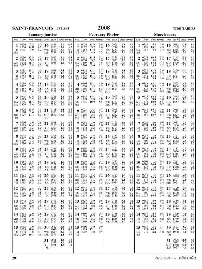
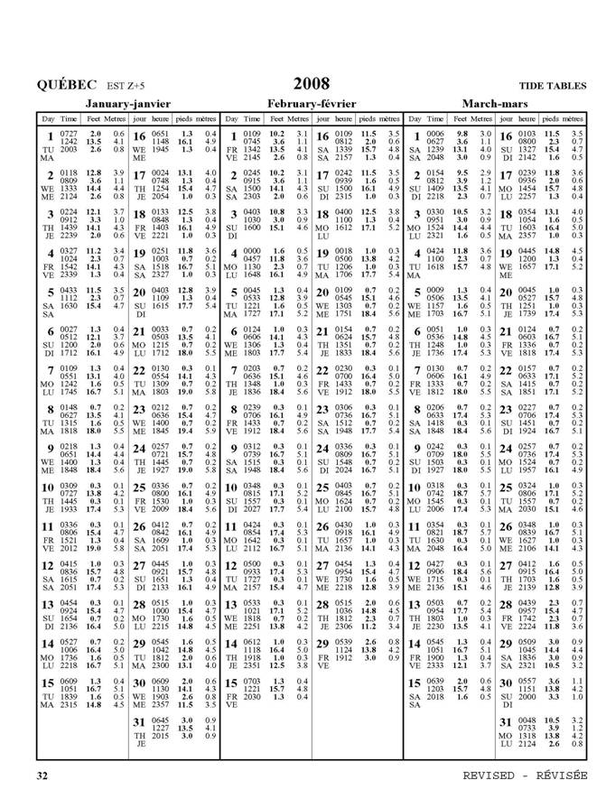
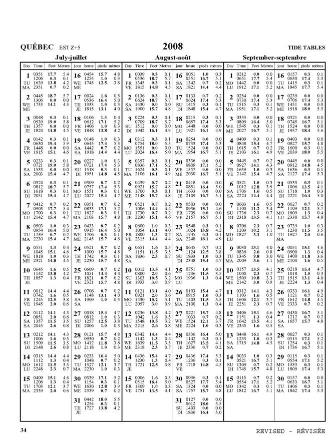
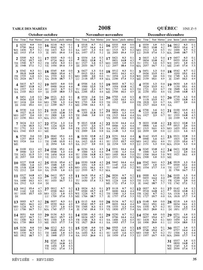
*605 CANADIAN HYDROGRAPHIC SERVICE - 2008 CANADIAN TIDE AND CURRENT TABLES.
|
Volume 3 (St. Lawrence River and Saguenay Fiord). Revised Tidal Predictions for the following Reference Ports: Saint-François Québec Grondines Replace pages 28 to 39 by the following pages. The revised predictions have been posted on the CHS Tidal Web Site: http://marees-tides.gc.ca/ |


*606(P) CARAQUET HARBOUR, BAIE DE SHIPPEGAN AND/ET MISCOU HARBOUR - LIGHT TO BE DISCONTINUED.
|
Reference chart: 4913 The Canadian Coast Guard intends to permanently discontinue the following aid to navigation: Shippegan Gully Inner Breakwater Light LL1250.6 (47°43' 22.8" N 64°40' 06" W) Comments on this action are solicited from Mariners and other interested parties. Comments should be directed to: Darren Gaudet, A/Superintendent of Aids to Navigation, Canadian Coast Guard, P.O. Box 1000, Dartmouth, NS, B2Y 3Z8 within three months from the date of this Notice. (Email: GaudetD@mar.dfo-mpo.gc.ca). Any objections raised must state the facts on which they are based and should include supporting information on safety, commerce and public benefit. (G20080-034) |
SECTION 2 – Edition 06/2008
CHART CORRECTIONS
1209 - Saint-Fulgence à/to Rivière Shipshaw - New Edition - 14-DEC-1984 - NAD 1927
|
20-JUN-2008 |
LNM/D. 11-JAN-2008 |
|
|
Delete |
rear range/leading light F G 78ft (Priv) with leading line, legend Monument Price and bearing legends 052° and 232° (See Chart No. 1, P20.2) |
232°, 118m from the front range/leading light |
|
(Q2008004) LL(1823) DFO(6407608-01) | ||
|
This notice might affect Electronic Navigational Chart: CA579077 | ||
|
Delete |
front range/leading light F G 53ft (Priv) (See Chart No. 1, P20.2) |
48°25'45.8"N 071°02'36.6"W |
|
(Q2008028) LL(1822) DFO(6407645-01) | ||
|
This notice might affect Electronic Navigational Chart: CA579077 | ||
|
Add |
sector light F RWG 30ft |
48°25'45.8"N 071°02'36.5"W |
|
Visible through an arc of 005º, red from 229° 30' to 231°30', alternating red and white from 231º30' to 231º50', white from 231°50' to 232°10', alternating green and white from 232º10' to 232º30' and green from 232°30' to 234°30'. Charted sector extend 1.2 NM from light. (See Chart No. 1, P30.3) | ||
|
(Q2008028) LL(1822) DFO(6407645-02) | ||
|
This notice might affect Electronic Navigational Chart: CA579077 | ||
1220 - Sept-Îles - New Edition - 09-JAN-2004 - NAD 1983
20-JUN-2008 |
LNM/D. 23-MAY-2008 |
|
Affix |
patch |
50°11'05.0"N 066°21'50.0"W |
DFO(6407644-01) |
||
This notice might affect Electronic Navigational Chart: CA579008 |
||
1226 - Quai Public/Public Wharf - New Edition - 19-NOV-1999 - NAD 1983
|
27-JUN-2008 |
LNM/D. 29-JUN-2007 |
|
|
Delete |
depth of 5 metres 8 decimetres (See Chart No. 1, I10) |
49°13'31.6"N 068°07'39.6"W |
|
DFO(6407627-04) | ||
|
This notice might affect Electronic Navigational Chart: CA579049 | ||
|
Add |
depth of 2 metres (See Chart No. 1, I10) |
49°13'42.3"N 068°08'01.8"W |
|
DFO(6407627-01) | ||
|
This notice might affect Electronic Navigational Chart: CA579049 | ||
|
Add |
depth of 1 metre 4 decimetres (See Chart No. 1, I10) |
49°13'40.5"N 068°07'57.1"W |
|
DFO(6407627-02) | ||
|
This notice might affect Electronic Navigational Chart: CA579049 | ||
|
Add |
depth of 3 metres 6 decimetres (See Chart No. 1, I10) |
49°13'30.5"N 068°07'37.8"W |
|
DFO(6407627-03) | ||
|
This notice might affect Electronic Navigational Chart: CA579049 | ||
1233 - Cap aux Oies à/to Sault-au-Cochon - New Edition - 09-NOV-2001 - NAD 1983
|
27-JUN-2008 |
LNM/D. 11-APR-2008 |
|
|
Delete |
calling-in point number 9 with arrowhead pointing 214° (See Chart No. 1, M40) |
47°14'55.6"N 070°33'24.2"W |
|
DFO(6407636-01) | ||
|
This notice might affect Electronic Navigational Chart: CA479021 | ||
|
Add |
calling-in point number 9 with arrowhead pointing 041° and 221° (See Chart No. 1, M40) |
47°11'18.5"N 070°37'12.4"W |
|
DFO(6407636-02) | ||
1236 - Pointe des Monts aux/to Escoumins - New Edition - 23-JUL-2004 - NAD 1983
|
27-JUN-2008 |
LNM/D. 25-APR-2008 |
|
|
Add |
depth of 4 metres 5 decimetres (See Chart No. 1, I10) |
49°03'30.7"N 068°17'07.6"W |
|
DFO(6407627-05) | ||
|
This notice might affect Electronic Navigational Chart: CA279037 | ||
1310 - Section B-C - New Edition - 15-FEB-2008 - NAD 1983
|
20-JUN-2008 | ||
|
Add |
limit of dredged channel (See Chart No. 1, I20) |
joining 45°34'00.0"N 073°30'43.3"W |
|
45°34'37.3"N 073°30'19.0"W |
||
|
45°35'10.0"N 073°30'09.4"W |
||
|
45°35'45.3"N 073°30'18.5"W |
||
|
45°36'32.0"N 073°30'14.5"W |
||
|
45°36'38.4"N 073°30'12.6"W |
||
|
and 45°36'42.0"N 073°30'10.3"W |
||
|
DFO(6407649-01) | ||
|
This notice might affect Electronic Navigational Chart: CA579080 | ||
|
27-JUN-2008 |
LNM/D. 20-JUN-2008 |
|
|
Amend |
calling-in point number 25 to read 26 (See Chart No. 1, M40) |
45°37'55.5"N 073°29'15.7"W |
|
DFO(6407634-01) | ||
|
Amend |
calling-in point number 26 to read 27 (See Chart No. 1, M40) |
45°31'36.7"N 073°31'39.8"W |
|
DFO(6407634-02) | ||
|
This notice might affect Electronic Navigational Chart: CA579080 | ||
1310 - Section A-B - New Edition - 15-FEB-2008 - NAD 1983
|
27-JUN-2008 |
LNM/D. 20-JUN-2008 |
|
|
Amend |
calling-in point number 25 to read 26 (See Chart No. 1, M40) |
45°37'55.5"N 073°29'15.7"W |
|
DFO(6407634-01) | ||
|
This notice might affect Electronic Navigational Chart: CA579001 | ||
1311 - Sorel-Tracy à/to Varennes - New Edition - 21-MAR-2008 - NAD 1983
|
27-JUN-2008 | ||
|
Amend |
calling-in point number 22 to read 23 (See Chart n° 1, M40) |
46°00'54.0"N 073°10'23.0"W |
|
DFO(6407646-04) | ||
|
This notice might affect Electronic Navigational Chart: CA479155 | ||
|
Amend |
calling-in point number 23 to read 24 (See Chart n° 1, M40) |
45°50'08.2"N 073°17'16.3"W |
|
DFO(6407646-05) | ||
|
This notice might affect Electronic Navigational Chart: CA479155 | ||
|
Amend |
calling-in point number 24 to read 25 (See Chart n° 1, M40) |
45°43'35.9"N 073°25'26.9"W |
|
DFO(6407646-06) | ||
|
This notice might affect Electronic Navigational Chart: CA479155 | ||
1311 - Terminal de Contrecoeur - New Edition - 21-MAR-2008 - NAD 1983
|
27-JUN-2008 | ||
|
Amend |
calling-in point number 23 to read 24 (See Chart n° 1, M40) |
45°50'08.1"N 073°17'16.6"W |
|
DFO(6407646-05) | ||
|
This notice might affect Electronic Navigational Chart: CA579156 | ||
1312 - Lac Saint-Pierre - New Edition - 08-JUN-2007 - NAD 1983
|
27-JUN-2008 |
LNM/D. 29-FEB-2008 |
|
|
Delete |
black, yellow and black East cardinal pillar buoy , marked Ours (See Chart n° 1, Q130.3) |
46°06'18.1"N 073°02'58.4"W |
|
(Q2008027) DFO(6407643-01) | ||
|
This notice might affect Electronic Navigational Chart: CA479129 | ||
|
Amend |
calling-in point number 19A to read 20 (See Chart n° 1, M40) |
46°16'25.9"N 072°37'16.8"W |
|
DFO(6407646-01) | ||
|
This notice might affect Electronic Navigational Chart: CA479129 | ||
|
Amend |
calling-in point number 20 to read 21 (See Chart n° 1, M40) |
46°12'41.0"N 072°49'01.5"W |
|
DFO(6407646-02) | ||
|
This notice might affect Electronic Navigational Chart: CA479129 | ||
|
Amend |
calling-in point number 21 to read 22 (See Chart n° 1, M40) |
46°05'12.0"N 073°00'19.8"W |
|
DFO(6407646-03) | ||
|
This notice might affect Electronic Navigational Chart: CA479129 | ||
|
Add |
yellow cautionary spar buoy, marked Ours (See Chart n° 1, Qm) |
46°05'55.6"N 073°03'26.0"W |
|
(Q2008027) DFO(6407643-02) | ||
|
This notice might affect Electronic Navigational Chart: CA479129 | ||
1312 - Port de Sorel-Tracy - New Edition - 08-JUN-2007 - NAD 1983
|
27-JUN-2008 |
LNM/D. 29-FEB-2008 |
|
|
Delete |
calling-in point 21A with arrowhead pointing 160.5° and 340.5° (See Chart No. 1, M40) |
46°02'34.1"N 073°07'07.4"W |
|
DFO(6407638-01) | ||
|
This notice might affect Electronic Navigational Chart: CA579130 | ||
1313 - Batiscan au/to Lac Saint-Pierre - New Edition - 02-FEB-2007 - NAD 1983
|
27-JUN-2008 |
LNM/D. 21-MAR-2008 |
|
|
Amend |
calling-in point number 19A to read 20 (See Chart n° 1, M40) |
46°16'26.2"N 072°37'17.1"W |
|
DFO(6407646-01) | ||
1315 - Québec à/to Donnacona - New Edition - 21-JUN-2002 - NAD 1983
|
27-JUN-2008 |
LNM/D. 14-MAR-2008 |
|
|
Amend |
calling-in point number 13 to read 12 (See Chart n° 1, M40) |
46°48'32.0"N 071°11'43.0"W |
|
DFO(6407641-01) | ||
|
This notice might affect Electronic Navigational Chart: CA479020 | ||
|
Amend |
calling-in point number 13A to read 13 (See Chart n° 1, M40) |
46°46'11.9"N 071°14'22.2"W |
|
DFO(6407641-02) | ||
|
This notice might affect Electronic Navigational Chart: CA479020 | ||
1316 - Port de Québec - New Edition - 23-JUN-2006 - NAD 1983
|
27-JUN-2008 |
LNM/D. 15-FEB-2008 |
|
|
Amend |
calling-in point number 13 to read 12 (See Chart No. 1, M40) |
46°48'33.3"N 071°11'48.7"W |
|
DFO(6407637-01) | ||
|
This notice might affect Electronic Navigational Chart: CA579003 | ||
|
Amend |
calling-in point number 13A to read 13 (See Chart No. 1, M40) |
46°46'12.0"N 071°14'24.0"W |
|
DFO(6407637-02) | ||
|
This notice might affect Electronic Navigational Chart: CA579003 | ||
|
Amend |
calling-in point number 12 to read 11 (See Chart No. 1, M40) |
46°50'22.9"N 071°07'51.0"W |
|
DFO(6407637-03) | ||
|
This notice might affect Electronic Navigational Chart: CA579003 | ||
1317 - Sault-au-Cochon à/to Québec - New Edition - 17-AUG-2001 - NAD 1983
|
27-JUN-2008 |
LNM/D. 18-JAN-2008 |
|
|
Delete |
calling-in point number 10 with arrowhead pointing 026° and 203° (See Chart No. 1, M40) |
47°06'24.8"N 070°42'28.5"W |
|
DFO(6407639-02) | ||
|
Add |
calling-in point number 9 with arrowhead pointing 041° and 221° (See Chart No. 1, M40) |
47°11'18.5"N 070°37'12.4"W |
|
DFO(6407639-01) | ||
1317 - Continuation A - New Edition - 17-AUG-2001 - NAD 1983
|
27-JUN-2008 |
LNM/D. 18-JAN-2008 |
|
|
Amend |
calling-in point number 11 to read 10 (See Chart No. 1, M40) |
46°51'15.2"N 071°00'07.3"W |
|
DFO(6407639-03) | ||
|
Amend |
calling-in point number 12 to read 11 (See Chart No. 1, M40) |
46°50'22.9"N 071°07'49.5"W |
|
DFO(6407639-04) | ||
|
Amend |
calling-in point number 13 to read 12 (See Chart No. 1, M40) |
46°48'34.6"N 071°11'45.0"W |
|
DFO(6407639-05) | ||
1350 - Sorel-Tracy - Sheet 1 - New Edition - 15-DEC-2006 - NAD 1983
|
27-JUN-2008 |
LNM/D. 23-MAY-2008 |
|
|
Delete |
calling-in point 21A with arrowhead pointing 160.5° and 340.5° (See Chart No. 1, M40) |
46°02'34.1"N 073°07'07.4"W |
|
DFO(6407638-01) | ||
1433 - Île St-Régis to/à Croil Islands B-C - New Chart - 28-MAY-1999 - NAD 1983
|
06-JUN-2008 |
LNM/D. 30-MAY-2008 |
|
|
Delete |
flagstaff (See Chart No. 1, E27) |
44°59'31.6"N 074°56'53.8"W |
|
DFO(6603185-02) | ||
|
Delete |
tank (See Chart No. 1, E32) |
44°57'52.0"N 074°55'02.5"W |
|
DFO(6603185-03) | ||
|
Delete |
tank (See Chart No. 1, E32) |
44°57'52.5"N 074°55'00.0"W |
|
DFO(6603185-04) | ||
|
Delete |
tank (See Chart No. 1, E32) |
44°57'53.9"N 074°54'58.0"W |
|
DFO(6603185-05) | ||
|
Delete |
tank (See Chart No. 1, E32) |
44°57'56.0"N 074°54'58.0"W |
|
DFO(6603185-06) | ||
|
Delete |
tank (See Chart No. 1, E32) |
44°57'54.0"N 074°54'56.0"W |
|
DFO(6603185-07) | ||
|
Delete |
tank (See Chart No. 1, E32) |
44°57'56.0"N 074°54'55.5"W |
|
DFO(6603185-08) | ||
|
Delete |
tank (See Chart No. 1, E32) |
44°57'57.0"N 074°54'54.5"W |
|
DFO(6603185-09) | ||
|
Delete |
islet (See Chart No. 1, K10) |
44°59'28.0"N 074°49'25.8"W |
|
DFO(6603185-10) | ||
|
Delete |
private light Fl Y (See Chart No. 1, P1) |
45°01'37.2"N 074°53'20.5"W |
|
DFO(6603185-12) | ||
|
Delete |
islet (See Chart No. 1, K10) |
44°59'19.3"N 074°52'58.4"W |
|
DFO(6603185-13) | ||
|
Add |
microwave tower with elevation of 101m, R Lts. (See Chart No. 1, Ec) |
45°00'30.2"N 075°00'26.8"W |
|
DFO(6603185-01) | ||
|
Add |
rock awash (See Chart No. 1, K12) |
44°59'28.0"N 074°49'25.8"W |
|
DFO(6603185-11) | ||
|
Add |
rock which covers and uncovers with drying height of 0.9m. (See Chart No. 1, K11) |
44°59'19.3"N 074°52'58.4"W |
|
DFO(6603185-14) | ||
1554 - Maraboo Lake à/to Bald Rock - Sheet 2 - New Edition - 16-JUN-2006 - NAD 1983
|
27-JUN-2008 | ||
|
Add |
red starboard hand spar buoy, marked K90 |
46°16'24.4"N 078°13'42.1"W |
|
(B2008076) DFO(6603213-01) | ||
2067 - Hamilton Harbour - New Edition - 15-JUN-2007 - World Geodetic System 1984
|
27-JUN-2008 | ||
|
Replace |
red starboard hand spar buoy with red starboard hand lighted spar buoy Fl R |
43°16'27.8"N 079°47'31.5"W |
|
LL(537.722) DFO(6603212-01) | ||
|
Replace |
red starboard hand spar buoy with red starboard hand lighted spar buoy Fl R |
43°16'18.0"N 079°47'20.3"W |
|
LL(537.724) DFO(6603212-02) | ||
2202 - Tomahawk Island to/à Twelve Mile Bay - Sheet 2 - New Edition - 05-JAN-2007 - NAD 1983
|
27-JUN-2008 |
LNM/D. 30-NOV-2007 |
|
|
Add |
submarine cable (See Chart No. 1, L30.1) |
joining 45°06'04.0"N 080°05'19.0"W |
|
45°06'02.7"N 080°05'15.0"W |
||
|
45°06'02.0"N 080°05'13.0"W |
||
|
45°06'01.2"N 080°05'10.2"W |
||
|
45°05'59.0"N 080°04'59.2"W |
||
|
45°05'59.0"N 080°04'48.0"W |
||
|
and 45°05'58.0"N 080°04'44.5"W |
||
|
DFO(6603207-01) | ||
2202 - Twelve Mile Bay to/à Rose Island - Sheet 3 - New Edition - 05-JAN-2007 - NAD 1983
|
27-JUN-2008 |
LNM/D. 30-NOV-2007 |
|
|
Add |
submarine cable (See Chart No. 1, L30.1) |
joining 45°06'05.5"N 080°05'38.0"W |
|
45°06'07.3"N 080°05'34.5"W |
||
|
45°06'07.9"N 080°05'30.0"W |
||
|
45°06'01.2"N 080°05'10.2"W |
||
|
45°05'59.0"N 080°04'59.2"W |
||
|
45°05'59.0"N 080°04'48.0"W |
||
|
and 45°05'58.0"N 080°04'44.5"W |
||
|
DFO(6603207-01) | ||
2225 - Approaches to / Approches à Parry Sound - New Edition - 08-MAR-1991 - NAD 1927
|
06-JUN-2008 |
LNM/D. 02-MAY-2008 |
|
|
Amend |
legend F G 40 ft to read F G 38 ft against light |
45°22'15.0"N 080°19'19.5"W |
|
(D2008017) LL(909) DFO(6603206-01) | ||
|
This notice might affect Electronic Navigational Chart: CA573283, CA573284 | ||
L/C2243 - Bateau Island to/à Byng Inlet - New Edition - 30-AUG-1985 - NAD 1927
|
06-JUN-2008 |
LNM/D. 02-MAY-2008 |
|
|
Amend |
legend F G 40 ft to read F G 38 ft against light |
45°22'15.0"N 080°19'19.5"W |
|
(D2008017) LL(909) DFO(6603206-01) | ||
L/C2300 - Lake Superior/Lac Supérieur - New Chart - 24-APR-1998 - NAD 1983
|
06-JUN-2008 |
LNM/D. 02-MAY-2008 |
|
|
Amend |
legend Fl 10s 31 ft to read Fl 10s 39m against light |
47°14'27.4"N 084°39'02.4"W |
|
DFO(6603204-01) | ||
|
This notice might affect Electronic Navigational Chart: CA173289 | ||
2307 - Coppermine Point to/à Cape Gargantua - New Edition - 09-JUN-2006 - NAD 1983
|
06-JUN-2008 |
LNM/D. 02-MAY-2008 |
|
|
Amend |
legend Fl 10s 30ft to read Fl 10s 129ft against light |
47°14'27.4"N 084°39'02.4"W |
|
DFO(6603204-01) | ||
|
This notice might affect Electronic Navigational Chart: CA373110 | ||
4024 - Baie des Chaleurs/Chaleur Bay aux/to Îles de la Madeleine - New Edition - 03-MAR-2000 - NAD 1983
|
27-JUN-2008 |
LNM/D. 21-DEC-2007 |
|
|
Delete |
depth of 3 metres 4 decimetres (See Chart No. 1, I10) |
48°01'33.4"N 065°28'56.6"W |
|
DFO(6407632-13) | ||
|
This notice might affect Electronic Navigational Chart: CA279075 | ||
|
Delete |
depth of 3 metres 7 decimetres (See Chart No. 1, I10) |
48°01'48.2"N 065°29'58.4"W |
|
DFO(6407632-14) | ||
|
This notice might affect Electronic Navigational Chart: CA279075 | ||
|
Replace |
depth of 4 metres with depth of 3 metres 2 decimetres (See Chart No. 1, I10) |
48°00'19.3"N 065°14'42.8"W |
|
DFO(6407631-06) | ||
|
This notice might affect Electronic Navigational Chart: CA279075 | ||
|
Add |
depth of 2 metres 3 decimetres (See Chart No. 1, I10) |
48°01'53.2"N 065°30'02.8"W |
|
DFO(6407632-10) | ||
|
This notice might affect Electronic Navigational Chart: CA279075 | ||
|
Add |
depth of 2 metres 6 decimetres (See Chart No. 1, I10) |
48°01'34.2"N 065°29'15.2"W |
|
DFO(6407632-11) | ||
|
This notice might affect Electronic Navigational Chart: CA279075 | ||
L/C4118 - Continuation A - New Edition - 13-NOV-1998 - NAD 1983
|
13-JUN-2008 |
LNM/D. 08-FEB-2008 |
|
|
Delete |
red and white fairway lighted pillar bell buoy Mo(A), marked marked HJ, BELL (See Chart No 1 Qh) |
44°27'15.0"N 066°02'30.0"W |
|
(F2004003) LL (232) DFO(6303844-01) | ||
4124 - Letete Passage, Letang Harbour and/et Blacks Harbour - New Edition - 07-APR-2000 - NAD 1983
|
20-JUN-2008 |
LNM/D. 28-DEC-2007 |
|
|
Delete |
BELL against black and yellow North cardinal lighted pillar buoy Q, marked SAA (See Chart No 1 Q130.3) |
45°02'31.7"N 066°54'08.0"W |
|
LL(70.5) DFO(6303876-01) | ||
4236 - Taylors Head to/à Shut-In Island - New Edition - 13-JUL-2001 - NAD 1983
20-JUN-2008 |
LNM/D. 06-MAY-2005 |
|
Affix |
patch |
44°44'00.0"N 063°01'00.0"W |
DFO(6303955-01) |
||
This notice might affect Electronic Navigational Chart: CA376083 |
||
4385 - Chebucto Head to/à Betty Island - New Edition - 07-JUN-1996 - NAD 1983
|
13-JUN-2008 |
LNM/D. 06-APR-2007 |
|
|
Add |
light FlR against red starboard hand conical buoy, marked AM64 (See Chart No 1 Qf) |
44°28'03.3"N 063°46'49.8"W |
|
(F2004177) LL(494.01) DFO(6303852-01) | ||
4386 - St.Margaret's Bay - New Edition - 16-JUL-2004 - NAD 1983
|
13-JUN-2008 |
LNM/D. 28-DEC-2007 |
|
|
Add |
light FlR against red starboard hand conical buoy, marked AM64 (See Chart No 1 Qf) |
44°28'03.3"N 063°46'49.8"W |
|
(F2004177) LL(494.01) DFO(6303852-01) | ||
4394 - Lahave River West Ironbound Island to/à Riverport - New Edition - 26-JUL-2002 - NAD 1983
|
13-JUN-2008 |
LNM/D. 04-APR-2008 |
|
|
Replace |
red starboard hand lighted pillar bell buoy QR, marked T54 with red, green and red starboard bifurcation lighted pillar bell buoy Fl(2+1) 6s, marked TD |
44°15'30.4"N 064°20'15.7"W |
|
(F2008011) LL (426.25)(F2008010) LL(426) DFO(6303849-01) | ||
4422 - Cardigan Bay - New Edition - 26-DEC-2003 - NAD 1983
|
13-JUN-2008 |
LNM/D. 07-SEP-2007 |
|
|
Delete |
red starboard hand spar buoy, marked NJ10 |
46°13'12.8"N 062°32'36.7"W |
|
(G2008004) DFO(6303835-01) | ||
4486 - Baie des Chaleurs/Chaleur Bay - New Edition - 19-FEB-1999 - NAD 1983
|
27-JUN-2008 |
LNM/D. 25-JAN-2008 |
|
|
Delete |
depth of 2 fathoms 5 feet (See Chart No. 1, I10) |
48°02'56.6"N 065°31'44.8"W |
|
DFO(6407632-05) | ||
|
This notice might affect Electronic Navigational Chart: CA376187 | ||
|
Delete |
depth of 2 fathoms (See Chart No. 1, I10) |
48°01'51.0"N 065°29'58.3"W |
|
DFO(6407632-06) | ||
|
This notice might affect Electronic Navigational Chart: CA376187 | ||
|
Delete |
depth of 2 fathoms 4 feet (See Chart No. 1, I10) |
48°01'34.6"N 065°29'21.4"W |
|
DFO(6407632-07) | ||
|
This notice might affect Electronic Navigational Chart: CA376187 | ||
|
Replace |
depth of 4 fathoms 2 feet with drying height of 0 fathom (See Chart No. 1, I10) |
48°00'47.2"N 065°15'07.1"W |
|
DFO(6407631-07) | ||
|
This notice might affect Electronic Navigational Chart: CA376187 | ||
|
Replace |
depth of 2 fathoms 1 foot with depth of 1 fathom 1 foot (See Chart No. 1, I10) |
48°02'13.7"N 065°30'12.3"W |
|
DFO(6407632-12) | ||
|
This notice might affect Electronic Navigational Chart: CA376187 | ||
|
Add |
depth of 1 fathom 4 feet (See Chart No. 1, I10) |
48°03'16.1"N 065°32'09.2"W |
|
DFO(6407632-08) | ||
|
This notice might affect Electronic Navigational Chart: CA376187 | ||
|
Add |
depth of 1 fathom 3 feet (See Chart No. 1, I10) |
48°02'54.5"N 065°31'34.5"W |
|
DFO(6407632-09) | ||
|
This notice might affect Electronic Navigational Chart: CA376187 | ||
|
Add |
depth of 1 fathom 1 foot (See Chart No. 1, I10) |
48°01'53.2"N 065°30'02.8"W |
|
DFO(6407632-10) | ||
|
This notice might affect Electronic Navigational Chart: CA376187 | ||
|
Add |
depth of 1 fathom 3 feet (See Chart No. 1, I10) |
48°01'34.2"N 065°29'15.2"W |
|
DFO(6407632-11) | ||
|
This notice might affect Electronic Navigational Chart: CA376187 | ||
4616 - Burin Harbours and Approches / et les approches - New Edition - 06-JUN-2003 - NAD 1983
|
13-JUN-2008 |
LNM/D. 14-DEC-2007 |
|
|
Delete |
overhead cable with vertical clearance of 100 feet |
between 46°59'00.0"N 055°12'15.0"W |
|
and 46°58'48.0"N 055°11'57.0"W |
||
|
DFO(6303839-01) | ||
L/C4624 - Long Island to/à St. Lawrence Harbours - New Edition - 07-JAN-2000 - NAD 1983
|
13-JUN-2008 |
LNM/D. 21-DEC-2007 |
|
|
Delete |
overhead cable with vertical clearance of 30 metres |
between 46°59'00.0"N 055°12'15.0"W |
|
and 46°58'48.0"N 055°11'57.0"W |
||
|
DFO(6303839-01) | ||
4702 - Corbett Island to/à Ship Harbour Head - New Edition - 28-MAY-2004 - NAD 1983
|
27-JUN-2008 |
LNM/D. 23-MAR-2007 |
|
|
Reposition |
yellow, black and yellow West cardinal lighted pillar buoy Q(9) 15s, marked NGM (See Chart No 1 Q130.3) |
from 52°51'34.0"N 055°47'20.0"W |
|
to 52°51'34.8"N 055°47'14.9"W |
||
|
(N2007042) LL(279.809) DFO(6303862-01) | ||
4921 - Abords de/Approches to Paspébiac - Sheet 1 - New Edition - 06-MAR-1998 - NAD 1983
|
27-JUN-2008 |
LNM/D. 18-APR-2008 |
|
|
Delete |
depth of 5 metres 8 decimetres (See Chart No. 1, I10) |
48°00'36.8"N 065°15'06.4"W |
|
DFO(6407631-01) | ||
|
This notice might affect Electronic Navigational Chart: CA479073 | ||
|
Delete |
depth of 5 metres 2 decimetres (See Chart No. 1, I10) |
48°00'18.7"N 065°14'36.9"W |
|
DFO(6407631-02) | ||
|
This notice might affect Electronic Navigational Chart: CA479073 | ||
|
Add |
depth of 4 metres 4 decimetres (See Chart No. 1, I10) |
48°00'37.9"N 065°15'10.9"W |
|
DFO(6407631-03) | ||
|
This notice might affect Electronic Navigational Chart: CA479073 | ||
|
Add |
depth of 3 metres 2 decimetres (See Chart No. 1, I10) |
48°00'19.0"N 065°14'41.9"W |
|
DFO(6407631-04) | ||
|
This notice might affect Electronic Navigational Chart: CA479073 | ||
|
Add |
drying height of 0 metre 1 decimetre (See Chart No. 1, I15) |
48°00'47.6"N 065°15'06.9"W |
|
DFO(6407631-05) | ||
|
This notice might affect Electronic Navigational Chart: CA479073 | ||
|
Add |
depth of 3 metres 5 decimetres (See Chart No. 1, I10) |
48°01'43.1"N 065°12'53.9"W |
|
DFO(6407631-08) | ||
|
This notice might affect Electronic Navigational Chart: CA479073 | ||
4921 - Havre de Beaubassin - Sheet 1 - New Edition - 06-MAR-1998 - NAD 1983
|
27-JUN-2008 |
LNM/D. 18-APR-2008 |
|
|
Delete |
depth of 0 metre 7 decimetres (See Chart No. 1, I10) |
48°02'06.2"N 065°29'03.8"W |
|
DFO(6407632-02) | ||
|
This notice might affect Electronic Navigational Chart: CA579061 | ||
|
Add |
depth of 0 metre 8 decimetres (See Chart No. 1, I10) |
48°02'04.3"N 065°28'54.4"W |
|
DFO(6407632-01) | ||
|
This notice might affect Electronic Navigational Chart: CA579061 | ||
|
Add |
drying height of 0 metre (See Chart No. 1, I15) |
48°02'06.3"N 065°29'04.1"W |
|
DFO(6407632-03) | ||
|
This notice might affect Electronic Navigational Chart: CA579061 | ||
|
Add |
drying height of 0 metre 4 decimetres (See Chart No. 1, I15) |
48°02'04.1"N 065°29'02.2"W |
|
DFO(6407632-04) | ||
|
This notice might affect Electronic Navigational Chart: CA579061 | ||
5033 - Hawke Bay and / et Squasho Run - New Chart - 09-MAY-2003 - NAD 1983
|
27-JUN-2008 |
LNM/D. 23-MAR-2007 |
|
|
Reposition |
yellow, black and yellow West cardinal lighted pillar buoy Q(9) 15s, marked NGM (See Chart No 1 Q130.3) |
from 52°51'34.0"N 055°47'20.0"W |
|
to 52°51'34.8"N 055°47'14.9"W |
||
|
(N2007042) LL(279.809) DFO(6303862-01) | ||
5043 - Quaker Hat to/à Cape Harrison - New Edition - 20-AUG-1999 - NAD 1983
|
20-JUN-2008 |
LNM/D. 04-APR-2008 |
|
|
Delete |
legend (89) |
54°53'58.0"N 057°53'26.0"W |
|
DFO(6303857-01) | ||
6213 - Whitefish Bay - Sheet 1 - New Edition - 08-FEB-2002 - NAD 1983
|
13-JUN-2008 |
LNM/D. 28-FEB-2003 |
|
|
Add |
submarine power cable (See Chart No. 1, L31.1) |
joining 49°25'21.0"N 093°59'55.0"W |
|
49°25'19.3"N 094°00'00.0"W |
||
|
49°25'24.6"N 094°00'01.2"W |
||
|
49°25'22.8"N 094°00'08.2"W |
||
|
and 49°25'23.0"N 094°00'21.0"W |
||
|
DFO(6603205-01) | ||
6287 - Minaki to/à Kenora - side 2 - Sheet 2 - New Edition - 07-JUN-2002 - NAD 1983
|
27-JUN-2008 |
LNM/D. 21-JUL-2006 |
|
|
Add |
submarine power cable (See Chart No. 1, L31.1) |
joining 49°46'15.7"N 094°34'59.5"W |
|
49°46'15.7"N 094°35'10.0"W |
||
|
49°46'11.6"N 094°35'32.1"W |
||
|
49°45'58.3"N 094°35'47.8"W |
||
|
49°46'02.0"N 094°35'49.1"W |
||
|
and 49°46'01.9"N 094°35'53.3"W |
||
|
DFO(6603208-01) | ||
SECTION 4 – Edition 06/2008
SAILING DIRECTIONS AND SMALL CRAFT GUIDE CORRECTIONS
ATL 100 - General Information - Atlantic Coast, Second Edition, 2007 -
Chapter 3 - Paragraph 271, line 6
Delete: Small Craft Warning
Replace by: Strong wind warning
(Q2008-034.1)
ATL 101 - Newfoundland - Northeast and East Coasts, First Edition, 1997 -
Chapter 3 - Paragraph 214, line 6 - after correction promulgated in Monthly Edition No. 5/2002
Insert: A large stone breakwater has been constructed from the outer end of the SE wharf to a point about 246 feet (75 m) off the outer end of the basin. A shoal with a reported depth of 2 feet (0.7 m) lies about 282 feet (25 m) WNW of the outer end of the breakwater; caution is advised.
(N2008-05.9)
ATL 109 - Gulf of St. Lawrence (Northeast Portion), First Edition, 2006 -
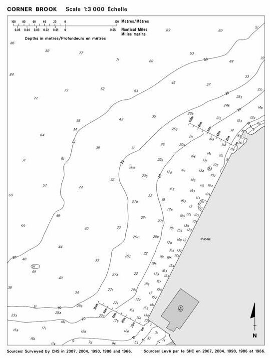
Chapter 4 - In the vicinity of paragraph 71
Replace the CORNER BROOK Diagram with the new one provided in Section IV of this Monthly Edition.
(N2008-05.8)
ATL 110 - St. Lawrence River - Cap Whittle/Gap Gaspé to Les Escoumins and Anticosti Island, Second Edition, 2002 -
Chapter 1 - In the vicinity of paragraph 283, Table 1.3 Sept-Îles - Wharves
Make the following correction in the "Depth" column.
| Berth | Depth metres |
| Quai de la relance | |
| 40 | 13.5 (Re: Correction promulgated in Monthly Edition No. 4/2004) |
| 41 | 10.8 (Re: Correction promulgated in Monthly Edition No. 4/2004) |
| (Q2008-021.1) | |
| Quai Pointe-Noire | |
| 30 | 15.8 (Re: Corrections promulgated in Monthly Edition No. 11/2002 and 4/2004) |
| 31 | |
| (Q2008-021.2) |
Chapter 1 - Paragraph 295, lines 4 to 7 (Re: Correction promulgated in Monthly Edition No. 8/2003)
Delete: "Although ... 12.7 m."
(Q2008-021.3)
Chapter 3 - Paragraph 177, lines 4 and 5
Delete: lie on Pointe au Père; the point is low.
Replace by: , lying on Pointe au Père which is low and rocky, have been rock bound and now form a large pier that extends 310 m to the NW. The submerged remains of the former wharf are at a depth of 2.4 m. Just downstream of the pier, an outfall pipe extends 430 m offshore in a NNW direction. Additionally, telecommunication submarine cables cross the river between Pointe au Père and Baie-Comeau. Mariners must consult the chart to find their location and should not anchor in the vicinity of these cables.
(Q2008-035.1)
ATL 111 - St. Lawrence River - Île Verte to Québec and Fjord du Saguenay, Third Edition, 2007 -
Chapter 2 - Paragraph 47, last line
Add: A shoal, at a depth of 3.6 m, lies immediately (47°03'N, 70°47'W) NW of the leading lights.
(Q2008-030.1)
Chapter 3 - Paragraph 124, lines 4 to 7
Delete: "• A fluorescent-orange ... 3 miles above Le Bassin."
(Q2008-030.2)
Chapter 3 - Paragraph 131, lines 6 and 7
Delete: "Île à Durand ... beacon."
(Q2008-030.3)
Chapter 3 - Delete paragraph 138.
(Q2008-030.4)
ATL 112 - St. Lawrence River - Cap-Rouge to Monréal and Rivière Richelieu, Second Edition, 2001 -
Chapter 2 - Paragraph 118, lines 3 and 4
Delete: "There are buoys ... the chart."
(Q2007-040.1)
SECTION 5 – Edition 06/2008
LIST OF LIGHTS, BUOYS AND FOG SIGNALS CORRECTIONS
|
NEWFOUNDLAND | ||||||||||
|
279.809 |
Gull and Matthews Rock West Cardinal light buoy NGM |
NNE. of Cape Bluff. 52 51 34.8 55 47 14.9 |
Q(9) |
W |
15s |
..... |
..... |
Yellow, black and yellow, marked "NGM". |
Seasonal. Chart:5033 Edn 06/08(N07-042) | |
|
ATLANTIC | ||||||||||
|
426 |
Cockawee Shoal light and bell buoy T54 |
Delete from list. Chart:4394 Edn 06/08(F08-010) |
||||||||
|
426.25 |
Cockawee Shoal bifurcation light and bell buoy TD |
N. of East Spectacle Island. 44 15 30.4 64 20 15.7 |
Fl (2+1) |
R |
6s |
..... |
..... |
Red, green, red, marked "TD". |
Year round. Chart:4394 Edn 06/08(F08-010) |
|
|
572.6 |
Jeddore Harbour light buoy YT9 |
44 43 10.7 63 00 16.9 |
Fl |
G |
4s |
..... |
..... |
Green, marked "YT9". |
Year round. Chart:4236 Edn 06/08(F08-037) |
|
|
573 |
Marsh Point light buoy YT11 |
44 43 23.6 63 00 11.7 |
Q |
G |
1s |
..... |
..... |
Green, marked "YT11". |
Year round. Chart:4236 Edn 06/08(F08-034) |
|
|
1523 H1878 |
Pointe de l'Ouest |
On W. extremity of island. 49 51 50.4 64 31 26.1 |
Fl |
W |
5s |
27.5 |
12 |
Skeleton tower. 19.8 |
Flash 1 s; eclipse 4 s. Operates at night only. Year round. Chart:4430 Edn 06/08(Q07-029) |
|
|
1822 1823 |
Monument Price range |
| | | | |
Delete from list. Chart:1209 Edn 06/08(Q08-004,028) |
|||||||
|
1822 |
Monument Price Sector |
48 25 45.8 71 02 36.5 |
F Al RW Al GW |
R W G |
..... |
9.1 |
13 |
Rectangular skeleton tower. |
Visible over an arc of 005°. Red from 229°30' to 231°30'; Al RW from 231°30' to 231°50'; white from 231°50' to 232°10'; Al GW from 232°10' to 232° 30'; green from 232°30' to 234°30'. Year round. Chart:1209 Edn 06/08(Q08-028) | |
|
INLAND WATERS | ||||||||||
|
537.722 |
Hamilton Harbour Pier 22 Middle North lighted spar buoy |
43 16 27.8 79 47 31.5 |
Fl |
R |
4s |
..... |
..... |
Red spar. |
Privately maintained. Seasonal. Chart:2067 Edn 06/08(B08-082) |
|
|
537.724 |
Hamilton Harbour Pier 22 South lighted spar buoy |
43 16 18 79 47 20.3 |
Fl |
R |
4s |
..... |
..... |
Red spar. |
Privately maintained. Seasonal. Chart:2067 Edn 06/08(B08-081) | |

