
Archived information
The Standard on Web Usability replaces this content. This content is archived because Common Look and Feel 2.0 Standards have been rescinded.
Archived information is provided for reference, research or recordkeeping purposes. It is not subject to the Government of Canada Web Standards and has not been altered or updated since it was archived.
|
|
Fisheries and Oceans Canada |
Pêches et Océans Canada |
VOL. 32, MONTHLY EDITION NO 06 JUNE 29, 2007 Publication Number 40063779 |
NOTICES TO MARINERS PUBLICATION EASTERN EDITION |
|||
Published monthly by the CANADIAN COAST GUARD |
|||
|
CONTENTS |
|||
Page |
|||
| Section 1 |
Safety and General Information | 1 - 11 | |
| Section 2 |
Chart Corrections | 12 -23 | |
| Section 3 |
Corrections to Radio Aids to Marine Navigation | 24 | |
| Section 4 |
Sailing Directions and Small Craft Guide Corrections | 25 - 30 | |
| Section 5 |
List of Lights, Buoys and Fog signals Corrections | 31, 34 | |
Maritime Services Directorate Aids to Navigation Internet: www.notmar.gc.ca | |||
|
EXPLANATORY NOTES |
|
Geographical positions refer directly to the graduations of the largest scale Canadian Hydrographic chart unless otherwise indicated. |
|
Bearingsrefer to the true compass and are measured clockwise from 000° (North) clockwise to 359°; those relating to lights are from seaward. |
|
Visibility of lights is that in clear weather. |
|
Depths - The units used for soundings (metres, fathoms or feet) are stated in the title of each chart. |
|
Elevationsare normally given above Higher High Water, Large Tides unless otherwise indicated. |
|
Distances may be calculated as follows: |
|
1 nautical mile = 1 852 metres (6,076.1 feet) 1 statute mile = 1 609.3 metres (5,280 feet) 1 metre = 3.28 feet |
|
Temporary & Preliminary Notices are indicated by a (T) or a (P) before the chart action. Please note that Nautical charts are not hand amended by the Canadian Hydrographic Service for Temporary (T) and Preliminary (P) Notices. It is recommended that mariners chart these corrections in pencil. Listing of charts affected by Temporary and Preliminary Notices are revised and promulgated quarterly in Section 1 of the Monthly Edition. |
|
Please note that, in addition to the temporary and preliminary changes normally advertised as (T) and (P) Notices, there are a significant number of permanent changes to navigational aids that have been advertised as Preliminary Notices to Mariners while charts are being updated for new editions. |
|
Marine Information Report & Suggestion Sheet- Mariners are requested to notify the responsible authorities when new or suspected dangers to navigation are discovered, changes observed in aids to navigation or corrections to publications are seen to be necessary. Such communications can be made using the Marine Information Report & Suggestion Sheet inserted on the last pageof each monthly edition of Notices to Mariners. |
|
Monthly edition of Notices to Mariners - Notices to Mariners are issued free of charge on a monthly basis. Mariners now have a choice between specific Regional issue(s) they wish to receive. Requests to be placed on or removed from the mailing list should be made by using the form inserted on page vi of each monthly edition. Notification of changes to the mailing addresses, regional issues and/or number of copies required should also be transmitted by means of this form. |
|
Canadian Nautical Charts & Publications - A source list of Canadian Nautical Charts & publications is published in Notice No. 14 of the current Annual Edition of Notices to Mariners. The source supply and the prices effective at the time of printing are listed. This list is periodically updated in the monthly edition of Notices to Mariners. |
|
NOTE: Cette publication est aussi disponible en français. |
|
CHART CORRECTIONS - SECTION 2 |
|
Corrections to nautical charts will be listed in numeric order by chart number. Each chart correction listed applies only to that particular chart. Related charts, if any, will have their own specific correction listed separately. Users should also refer to CHS Chart 1 Symbols, Abbreviations Terms for additional information pertaining to the correction of charts. The illustration below describes the elements that will comprise a typical Section 2 chart correction. |

| ADVISORY |
|
NOTICES TO SHIPPING (WRITTEN AND BROADCAST) |
|
The Canadian Coast Guard is implementing a number of changes to the aids to navigation system in Canada. |
|
These changes are advertised as Notices to Shipping (Broadcast and Written) by the Canadian Coast Guard and are followed up with Notices to Mariners, then charts are updated by hand correction, reprints or new editions. |
|
Mariners are advised that all relevant Written Notices to Shipping should be kept until superseded by Notices to Mariners or through revised charts issued by the Canadian Hydrographic Service. |
|
Written Notices to Shipping are published weekly and are available from local Canadian Coast Guard Offices. |
|
The Canadian Hydrographic Service is reviewing the impact of these changes with the Canadian Coast Guard and together we are preparing an action plan on the issuing of chart revisions. |
|
For further information contact your local Canadian Coast Guard office. |
|
|

|
DGPS FULLY OPERATIONAL SERVICE |
|
The Canadian Coast Guard (CCG) announces that the Differential Global Positioning Service (DGPS) Fully Operational Service (FOS) is available for positioning and navigation. |
|
FOS means the service will provide a DGPS broadcast using the type 9 RTCM message for pseudorange corrections at a data transmission rate of 200 baud. Refer to Radio Aids to Marine Navigation (RAMN) for estimated advertised coverage for each differential station. |
|
Users are also advised that differential corrections are based on the NAD 83 datum position of the reference station antenna and positions obtained using DGPS should be referenced to this coordinate system only. DGPS receivers must be set to the WGS 84 datum in order to obtain optimum positioning accuracy. |
|
Table of DGPS Reference Stations in Canada | ||||||
| Station Name |
Id. Nos
|
DGPS
| Geog. Position |
Frequency
[kHz] |
Bit/s | |
|
|
|
|
Latitude | Longitude | ||
|
Cape Race, NL |
338,339 |
940 |
46 46 N |
53 11 W |
315 |
200 |
|
Cape Ray, NL |
340,341 |
942 |
47 38 N |
59 14 W |
288 |
200 |
|
Cape Norman, NL |
342,343 |
944 |
51 30 N |
55 49 W |
310 |
200 |
|
Rigolet, NL |
344,345 |
946 |
54 11 N |
58 27 W |
299 |
200 |
|
Partridge Island, NB |
326,327 |
939 |
45 14 N |
66 03 W |
295 |
200 |
|
Pt. Escuminac, NB |
332,333 |
936 |
47 04 N |
64 48 W |
319 |
200 |
|
Fox Island, NS |
336,337 |
934 |
45 20 N |
61 05 W |
307 |
200 |
|
Western Head, NS |
334,335 |
935 |
43 59 N |
64 40 W |
312 |
200 |
|
Hartlen Point, NS |
330,331 |
937 |
44 36 N |
63 27 W |
298 |
200 |
|
St.-Jean-sur-Richelieu, QC |
312,313 |
929 |
45 19 N |
73 19 W |
296 |
200 |
|
Lauzon, QC |
316,317 |
927 |
46 49 N |
71 10 W |
309 |
200 |
|
Rivière-du-Loup, QC |
318,319 |
926 |
47 46 N |
69 36 W |
300 |
200 |
|
Moisie, QC |
320,321 |
925 |
50 12 N |
66 07 W |
313 |
200 |
|
Wiarton, ON |
310,311 |
918 |
44 45 N |
81 07 W |
286 |
200 |
|
Cardinal, ON |
308,309 |
919 |
44 47 N |
75 25 W |
306 |
200 |
|
Alert Bay, BC |
300,301 |
909 |
50 35 N |
126 55 W |
309 |
200 |
|
Amphitrite Pt., BC |
302,303 |
908 |
48 55 N |
125 33 W |
315 |
200 |
|
Richmond, BC |
304,305 |
907 |
49 11 N |
123 07 W |
320 |
200 |
|
Sandspit, BC |
306,307 |
906 |
53 14 N |
131 49 W |
300 |
200 |
| DGPS RECEIVER - WARNING |
|
The Canadian Coast Guard's Differential Global Positioning System (DGPS) broadcast contains built in health information designed to alert a DGPS user receiver of an out of tolerance or fault condition. During testing, it was found that some user DGPS receivers did not process the health information properly. Improper processing by a user equipment can result in incorrect positions. |
|
Please contact your DGPS manufacturer or supplier to ensure that your receiver is capable of processing the DGPS Reference Station Health information correctly. |
| DGPS USER ALERT |
|
The Canadian Coast Guard received reports in March 97 of DGPS receivers apparently ignoring the broadcast alarm which should signal the immediate discontinuation of a particular satellite correction. Reports indicate that some user equipment does not properly recognize this "do-not-use" correction flag and as a result erroneously processes it as a correction. This can result in position errors as large as 15 kilometers while the receiver is in DGPS mode. DGPS users are advised that they should contact the manufacturer of their equipment immediately to determine if they require a receiver upgrade. |
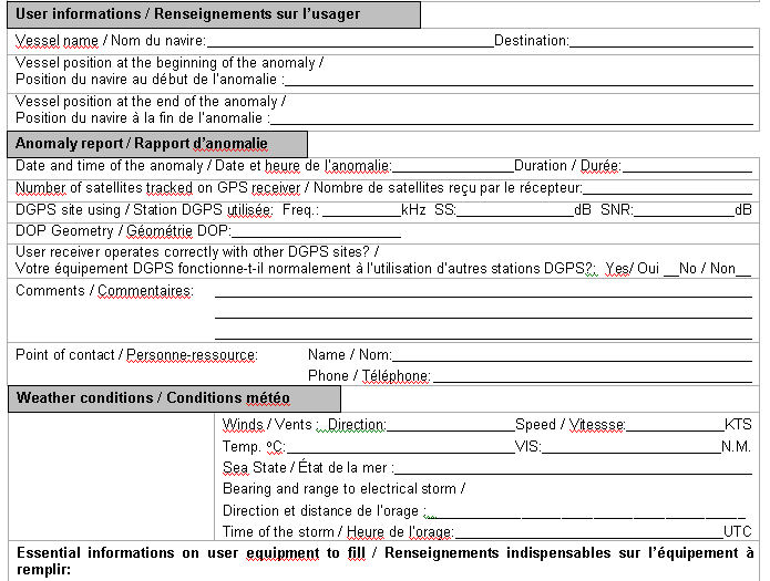
| DGPS station anomaly report / Rapport d'anomalie des stations DGPS |
|
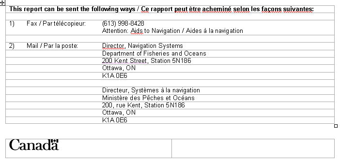
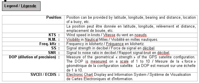
With the purpose of constantly evaluating the quality of the DGPS service offered, the Canadian Coast Guard is providing the mariner with the following anomaly report. This report will allow us to get well-supported information concerning the anomaly and thus, will facilitate the identification of the origin of the problem. Please fill accordingly each section of this report and forward it by the suggested ways. You will find a legend at the end of this document. |
Avec le souci d'évaluer constamment la qualité du service DGPS offert, la Garde côtière met à la disposition du navigateur le présent rapport d'anomalie. Ce rapport servira à bien documenter l'anomalie et, de ce fait, facilitera l'identification ou la recherche de la source du problème. Nous vous prions de bien remplir chaque section de ce rapport et de l'acheminer de la façon suggérée. Vous trouverez une légende à la fin de ce document.

|
MONTHLY EDITION OF NOTICES TO MARINERS |
MAILING LIST CHANGES |
|
|
|
Telephone (613) 990-303 Facsimile (613) 998-8428 |
|
Internet www.notmar.gc.ca |
|
Please indicate which edition you would like to receive. |
|
EASTERN EDITION (Comprised of Arctic, Newfoundland, Maritimes, Gulf & River St. Lawrence and Central areas) ________ |
|
WESTERN EDITION (Comprised of Arctic and Pacific areas)________ |
|
|

INDEX |
|
CANADIAN COAST GUARD - MARINE COMMUNICATION AND TRAFFIC SERVICES (MCTS). |
2 |
| CANADIAN COAST GUARD PUBLICATION - AMENDMENT TO THE RADIO AIDS TO MARINE NAVIGATION (ATLANTIC, ST-LAWRENCE, GREAT LAKES, LAKE WINNIPEG AND EASTERN ARCTIC) PUBLICATION 2007. | 24 |
| CANADIAN HYDROGRAPHIC SERVICE - ANNOUNCEMENT REGARDING CANADIAN HYDROGRAPHIC SERVICE CHART PATCHES. | 1 |
CANADIAN HYDROGRAPHIC SERVICE - ARCTIC CHARTS. |
2 |
| CANADIAN HYDROGRAPHIC SERVICE - CUMULATIVE CHART CORRECTIONS. | 1 |
CANADIAN HYDROGRAPHIC SERVICE - CURRENT CHART EDITION DATES. |
1 |
CANADIAN HYDROGRAPHIC SERVICE - PRINT ON DEMAND CHARTS - CARE AND USE. |
1 |
*602 CANADIAN HYDROGRAPHIC SERVICE - ELECTRONIC NAVIGATION CHARTS. |
2 |
*604 CANADIAN HYDROGRAPHIC SERVICE - LIST OF CHARTS NOT HAND-CORRECTED. |
7 |
*605 CANADIAN HYDROGRAPHIC SERVICE - NON EQUIVALENT ELECTRONIC NAVIGATION CHARTS. |
8 |
| *603 CANADIAN HYDROGRAPHIC SERVICE - RASTER NAVIGATION CHARTS. | 2 |
*608 CANADIAN COAST GUARD PUBLICATION - AMENDMENT TO THE 2007 ANNUAL EDITION OF NOTICES TOMARINERS 1 TO 46 - NOTICE NO. 40. |
10 |
*607 CANADIAN COAST GUARD PUBLICATION - AMENDMENT TO THE 2007 ANNUAL EDITION OF NOTICES TOMARINERS 1 TO 46 - FRENCH VERSION - NOTICE NO. 30. |
9 |
*606 CANADIAN COAST GUARD PUBLICATION - NEW EDITION OF THE ATLANTIC COAST LIST OF LIGHTS, BUOYS AND FOG SIGNALS - 2007. |
9 |
| *617(T) CANADIAN COAST GUARD - TRANSPORT CANADA - LAURENTIAN PILOTAGE AUTHORITY - VESSELS WITH BEAM GRATER THAN 32.5 METRES. | 10 |
| *610(P) CARIBOU HARBOUR - RANGE LIGHTS TO BE DISCONTINUED. | 11 |
| *609 COUNTRY ISLAND TO/À BARREN ISLAND - BUOY DISCONTINUED. | 11 |
| *616(T) DEMARCATION BAY TO/ A PHILIPS BAY - MOBILE OFFSHORE DRILLING UNIT TEMPORARILY ESTABLISHED. | 11 |
NUMERICAL INDEX OF CANADIAN CHARTS AFFECTED |
|||||
Chart No. |
Page |
Chart No. |
Page |
Chart No. |
Page |
| 1226 | 12 | 6021 | 21 | ||
| 1315 | 12 | 6022 | 21 | ||
| 1316 | 12 | 6212 | 21 | ||
| 1432 | 12 | 6217 | 22,23 | ||
| 1433 | 13 | 6218 | 23 | ||
| 1437 | 13 | 6273 | 23 | ||
| 2067 | 13 | ||||
| 2283 | 13-15 | ||||
| L/C2302 | 15 | ||||
| 2312 | 15 | ||||
| L/C4002 | 15 | ||||
| 4003 | 16 | ||||
| 4021 | 16 | ||||
| 4023 | 17 | ||||
| 4024 | 17 | ||||
| 4140 | 17 | ||||
| 4233 | 17 | ||||
| 4266 | 17 |
|
|
||
| 4321 | 18 |
|
|
||
| 4367 | 18 |
|
|
||
| 4425 | 18 |
|
|
||
| 4485 | 18 |
|
|
||
| 4821 | 18 |
|
|
||
| L/C4841 | 18,19 |
|
|
||
| 4849 | 19 |
|
|
||
| 4885 | 19-21 |
|
|
||
| 4950 | 21 |
|
|
||
SECTION 1 – Edition 06/2007
SAFETY AND GENERAL INFORMATION
CANADIAN HYDROGRAPHIC SERVICE - ANNOUNCEMENT REGARDING CANADIAN HYDROGRAPHIC SERVICE CHART PATCHES.
CHS is introducing a new initiative with a full colour Patch on the Web. A link in the Notices to Mariners web site will be provided so clients can access the colour Patch. The colour Patch will be published in HTML and PDF format. Providing the Patches in colour (accessible to all via remote access to the Web) is an enhanced form of alternative service delivery in line with CHS strategic objectives.
Colour Web Patches are free to the mariner, and given the quality of many printers, should reproduce well. They will be available in real time all around the world which is an improvement since clients had to wait for the paper copy to be mailed.
Previously, in the Notices to Mariners (NTM) booklet, Patches were produced in full colour or a minimum of black and magenta.
Due to current budgetary constraints, Patches will now only be produced in black and white for publication in the NTM booklet.
Our level of service will change with this initiative and CHS intends to analyze market reaction to this innovation.
CHS welcomes your feedback on this new service at chsinfo@dfo-mpo.gc.ca
CANADIAN HYDROGRAPHIC SERVICE - CUMULATIVE CHART CORRECTIONS.
The cumulative Notice to Mariners corrections for charts can now be accessed at http://www.notmar.gc.ca/search/notmar-eng.php
CANADIAN HYDROGRAPHIC SERVICE - CURRENT CHART EDITION DATES.
CHART EDITIONS |
The three terms described below are used to indicate the publication status of Canadian charts. |
NEW CHART - "NEWCHT" |
The first publication of a Canadian chart embracing an area not previously charted to the scale shown, or embracing an area different from any existing Canadian chart. |
NEW EDITION - "NEWEDT" |
A new issue of an existing chart containing amendments essential to navigation in addition to those issued in Notice to Mariners and making existing editions obsolete. |
REPRINTS |
A new issue of the current edition of a chart incorporating no amendments of navigational significance other than those previously promulgated in Notice to Mariners. It may also contain amendments from other sources provided they are not essential to navigation. Previous printings of the current edition remain in force. |
The current chart edition dates can now be accessed at http://www.chs-shc.gc.ca/pub/en/products/core.cfm
CANADIAN HYDROGRAPHIC SERVICE - PRINT ON DEMAND CHARTS - CARE AND USE.
Background By providing nautical charts to the public, the goal of the Canadian Hydrographic Service (CHS) is to provide services for safe navigation in a fiscally responsible manner. As a result, CHS continues to expand its portfolio of nautical paper charts that are printed using Print On Demand (POD) technology. These charts are easily recognized by their whiter paper and the coloured logo of the Canadian Hydrographic Service. This new technology enables CHS to print charts in a more efficient manner while enhancing chart content through being able to quickly add new and important information. POD technology provides customers with up-to-date charts without the historical hand-drawn corrections or glued-on patches. Additionally, this technology eliminates out-of-stock situations which arise with the traditional printing and warehousing methods. In the event of a national emergency, CHS can respond to the appropriate authorities with best available information very quickly. Care of Your POD Chart CHS encourages its customers to handle the POD charts more carefully than the traditional lithographic charts. When plotting information on POD charts, use HB pencils and apply limited pressure. Testing has suggested that an Indian gum eraser is more effective than alternatives when used on the product. This eraser is also suitable for charts printed using lithographic processes. |
CANADIAN HYDROGRAPHIC SERVICE - ARCTIC CHARTS.
Please be advised that effective February 2007 all Arctic notices will appear in both the Eastern and Western paper editions of Notices to Mariners.
Mariners may obtain all Arctic chart notices via the Canadian Coast Guard Notices to Mariners online service www.notmar.gc.ca or by contacting the Canadian Coast Guard, Notices to Mariners office at the following coordinates:
Leader, Notices to Mariners
Aids to Navigation
Navigation Systems
Canadian Coast Guard
200 Kent Street, Station 5N186
Ottawa, ON
K1A 0E6
Telephone (613) 993-6974
Facsimile (613) 998-8428
CANADIAN COST GUARD - MARINE COMMUNICATION AND TRAFFIC SERVICES (MCTS).
Marine Communications and Traffic Services will no longer provide the radiotelegram service subject to full international charges after December 31st, 2007. However, messages addressed to "Quarantine" and messages requesting a doctor to meet a ship on arrival will now be handled without charge. MCTS will continue to provide a Marine Telephone Call Service subject to full international charges in selected areas, based upon demand and the availability of alternate service delivery methods.
*602 CANADIAN HYDROGRAPHIC SERVICE - ELECTRONIC NAVIGATION CHARTS.
RELEASED PRODUCTS |
|
S-57 ENC NUMBER |
CHART TITLE |
CA673358 |
Trapp Rock |
CA470017 |
Discovery Passage |
CA570018 |
Seymour Narrows |
CA576497 |
Paradise River |
*603 CANADIAN HYDROGRAPHIC SERVICE - RASTER NAVIGATION CHARTS.
CHARTS |
MAIN TITLE |
|
|
|
|
New Chart |
All temporary and preliminary notices affecting the previous versions of the following chart(s) (is / are) now cancelled. For any outstanding notices please consult section 2 of this edition. |
||||
R/M2017 |
Kingston Harbour and Approaches/et les approaches |
|
13-JUL-1990 |
|
See Note 2 |
New Chart |
All temporary and preliminary notices affecting the previous versions of the following chart(s) (is / are) now cancelled. For any outstanding notices please consult section 2 of this edition. |
||||
R/M2018 |
Lower Gap to/à Adolphus Reach |
|
22-JUN-1990 |
|
See Note 2 |
R/M2241 |
Port Severn to/à Christian Island |
|
30-JUL-1999 |
|
See Note 2 |
R/M6205 |
Seven Sisters Falls to/à Lac du Bonnet |
|
30-JUN-1995 |
|
See Note 2 |
R/M6209 |
Brereton Lake |
|
04-SEP-1970 |
|
See Note 2 |
R/M6242A |
Winnipeg to Lake Winnipeg |
|
01-MAY-1992 |
|
See Note 2 |
R/M6242A |
Winnipeg to Selkirk |
|
01-MAY-1992 |
|
See Note 2 |
R/M6242B |
Winnipeg to Lake Winnipeg |
|
01-MAY-1992 |
|
See Note 2 |
R/M6242B |
Selkirk to Lake Winnipeg |
|
01-MAY-1992 |
|
See Note 2 |
R/M6247 |
Wightman Point to/à Whiskey Jack Portage |
|
19-FEB-1993 |
|
See Note 2 |
R/M6258 |
Montréal Point to/à Kettle Island |
|
30-DEC-1988 |
|
See Note 2 |
R/M6259 |
Kettle Island to/à Martin Point |
|
23-FEB-1990 |
|
See Note 2 |
R/M6260 |
Martin Point to/à Wightman Point |
|
06-JAN-1989 |
|
See Note 2 |
R/M6263 |
Playgreen Lake to/au Little Playgreen Lake |
|
14-APR-1989 |
|
See Note 2 |
R/M6264 |
East Channel to/au Little Playgreen Lake |
|
14-APR-1989 |
|
See Note 2 |
R/M6267 |
Grindstone Point to Berens River |
|
09-JUL-1965 |
|
See Note 2 |
R/M6271 |
Winnipegosis to Red Deer Point |
|
15-NOV-2002 |
|
See Note 2 |
R/M6281 |
Lac La Ronge |
|
02-JUN-2000 |
|
See Note 2 |
R/M6285 |
Eaglenest Lake to/à Whitedog Dam |
|
03-JUN-1988 |
|
See Note 2 |
R/M6505 |
Lake Manitoba / Lac Manitoba (Southern Portion / Partie sud) |
|
05-APR-1985 |
|
See Note 2 |
R/M6506 |
Lake Manitoba / Lac Manitoba (Northern Portion / Partie nord) |
|
12-APR-1985 |
|
See Note 2 |
New Edition |
All temporary and preliminary notices affecting the previous versions of the following chart(s) (is / are) now cancelled. For any outstanding notices please consult section 2 of this edition. |
||||
R/M2006 |
Upper Gap to/à Telegraph Narrows |
|
31-MAR-2000 |
|
See Note 2 |
R/M2007 |
Belleville to/à Telegraph Narrows |
|
10-SEP-1982 |
|
See Note 2 |
R/M2011 |
Belleville Harbour |
|
17-JAN-2003 |
|
See Note 2 |
R/M2021A |
Murray Canal to Healey Falls Locks / Murray Canal aux Écluses de Healey Falls |
|
10-AUG-2001 |
|
See Note 2 |
R/M2021A |
Murray Canal Presqu'Ile Bay to/à Trenton |
|
10-AUG-2001 |
|
See Note 2 |
R/M2021B |
Murray Canal to Healey Falls Locks / Murray Canal aux Écluses de Healey Falls |
|
10-AUG-2001 |
|
See Note 2 |
R/M2021B |
Trenton to/à Glen Ross |
|
10-AUG-2001 |
|
See Note 2 |
R/M2021C |
Murray Canal to Healey Falls Locks / Murray Canal aux Écluses de Healey Falls |
|
10-AUG-2001 |
|
See Note 2 |
R/M2021C |
Glen Ross to Hagues Reach Lock / Glen Ross à l'ecluse de Hagues Reach |
|
10-AUG-2001 |
|
See Note 2 |
R/M2021D |
Murray Canal to Healey Falls Locks / Murray Canal aux Écluses de Healey Falls |
|
10-AUG-2001 |
|
See Note 2 |
R/M2021D |
Hagues Reach Lock to Healey Falls Locks / Écluse de Hagues Reach aux Écluses de Healey Falls |
|
10-AUG-2001 |
|
See Note 2 |
R/M2022A |
Healey Falls Locks to Peterborough / Écluses de Healey Falls à Peterboroough |
|
09-JAN-2004 |
|
See Note 2 |
R/M2022A |
Healey Falls Locks to Rice Lake / Écluses de Healey Falls au Rice Lake |
|
09-JAN-2004 |
|
See Note 2 |
R/M2022B |
Healey Falls Locks to Peterborough / Écluses de Healey Falls à Peterboroough |
|
09-JAN-2004 |
|
See Note 2 |
R/M2022B |
Rice Lake |
|
09-JAN-2004 |
|
See Note 2 |
R/M2022C |
Healey Falls Locks to Peterborough / Écluses de Healey Falls à Peterboroough |
|
09-JAN-2004 |
|
See Note 2 |
R/M2022C |
Rice Lake to/à Peterborough |
|
09-JAN-2004 |
|
See Note 2 |
R/M2023A |
Peterborough to/à Buckhorn including/y compris Stony Lake |
|
14-JUL-2006 |
|
See Note 2 |
R/M2023A |
Peterborough to/à Lakefield |
|
14-JUL-2006 |
|
See Note 2 |
R/M2023B |
Peterborough to/à Buckhorn including/y compris Stony Lake |
|
14-JUL-2006 |
|
See Note 2 |
R/M2023B |
Lakefield to/à Buckhorn |
|
14-JUL-2006 |
|
See Note 2 |
R/M2023C |
Peterborough to/à Buckhorn including/y compris Stony Lake |
|
14-JUL-2006 |
|
See Note 2 |
R/M2023C |
Stony Lake |
|
14-JUL-2006 |
|
See Note 2 |
R/M2024A |
Buckhorn to/à Bobcaygeon including/y compris Chemong Lake |
|
16-MAY-2003 |
|
See Note 2 |
R/M2024A |
Buckhorn to/à Gannon Narrows and/et Harrington Narrows |
|
16-MAY-2003 |
|
See Note 2 |
R/M2024B |
Buckhorn to/à Bobcaygeon including/y compris Chemong Lake |
|
16-MAY-2003 |
|
See Note 2 |
R/M2024B |
Gannon Narrows to/à Bobcaygeon |
|
16-MAY-2003 |
|
See Note 2 |
R/M2024C |
Buckhorn to/à Bobcaygeon including/y compris Chemong Lake |
|
16-MAY-2003 |
|
See Note 2 |
R/M2024C |
Chemong Lake |
|
16-MAY-2003 |
|
See Note 2 |
R/M2024D |
Buckhorn to/à Bobcaygeon including/y compris Chemong Lake |
|
16-MAY-2003 |
|
See Note 2 |
R/M2024D |
Pigeon Lake (Southern Portion/Partie Sud) |
|
16-MAY-2003 |
|
See Note 2 |
R/M2024E |
Buckhorn to/à Bobcaygeon including/y compris Chemong Lake |
|
16-MAY-2003 |
|
See Note 2 |
R/M2024E |
Pigeon Lake (North Portion/Partie Nord) |
|
16-MAY-2003 |
|
See Note 2 |
R/M2025A |
Bobcaygeon to Lake Simcoe / Bobcaygeon au Lake Simcoe |
|
23-APR-2004 |
|
See Note 2 |
R/M2025A |
Bobcaygeon to/au Balsam Lake |
|
23-APR-2004 |
|
See Note 2 |
R/M2025B |
Bobcaygeon to Lake Simcoe / Bobcaygeon au Lake Simcoe |
|
23-APR-2004 |
|
See Note 2 |
R/M2025B |
Balsam Lake |
|
23-APR-2004 |
|
See Note 2 |
R/M2025C |
Bobcaygeon to Lake Simcoe / Bobcaygeon au Lake Simcoe |
|
23-APR-2004 |
|
See Note 2 |
R/M2025C |
Balsam Lake to/au Lake Simcoe |
|
23-APR-2004 |
|
See Note 2 |
R/M2026A |
Lake Scugog and/et Scugog River |
|
|
|
See Note 2 |
R/M2026A |
Scugog River |
|
|
|
See Note 2 |
R/M2026B |
Lake Scugog and/et Scugog River |
|
|
|
See Note 2 |
R/M2026B |
Lake Scugog |
|
|
|
See Note 2 |
R/M2028A |
Lakes Simcoe and Couchiching including the Holland River/Lacs Simcoe et Couchiching y compris Holland River |
|
02-AUG-2002 |
|
See Note 2 |
R/M2028A |
Lake Simcoe |
|
02-AUG-2002 |
|
See Note 2 |
R/M2028B |
Lakes Simcoe and Couchiching including the Holland River/Lacs Simcoe et Couchiching y compris Holland River |
|
02-AUG-2002 |
|
See Note 2 |
R/M2028B |
Lake Couchiching Lake Simcoe to Couchiching Lock/Lake Simcoe à L'Écluse de Couchiching |
|
02-AUG-2002 |
|
See Note 2 |
R/M2028C |
Lakes Simcoe and Couchiching including the Holland River/Lacs Simcoe et Couchiching y compris Holland River |
|
02-AUG-2002 |
|
See Note 2 |
R/M2028C |
Cook's Bay and/et Holland River |
|
02-AUG-2002 |
|
See Note 2 |
R/M2029A |
Couchiching Lock to Port Severn / Écluse de Couchiching a Port Severn |
|
|
|
See Note 2 |
R/M2029A |
Couchiching Lock to Big Chute / Écluse de Couchiching a Big Chute |
|
|
|
See Note 2 |
R/M2029B |
Couchiching Lock to Port Severn / Écluse de Couchiching a Port Severn |
|
|
|
See Note 2 |
R/M2029B |
Big Chute to/à Port Severn |
|
|
|
See Note 2 |
R/M2064 |
Kingston to/` False Duck Islands |
|
05-MAR-1999 |
|
See Note 2 |
R/M2069 |
Picton to/à Presqu'ile Bay |
|
19-MAY-2000 |
|
See Note 2 |
R/M6201 |
Lake of the Woods |
|
08-AUG-2002 |
|
See Note 2 |
R/M6206 |
Seven Sisters Falls to/à Slave Falls |
|
15-SEP-2000 |
|
See Note 2 |
R/M6207 |
Slave Falls to/à Eaglenest Lake |
|
24-MAR-2000 |
|
See Note 2 |
R/M6211A |
Big Traverse Bay |
|
08-FEB-2002 |
|
See Note 2 |
R/M6211B |
Big Traverse Bay |
|
08-FEB-2002 |
|
See Note 2 |
R/M6212A |
Kenora to/à Aulneau Peninsula |
|
08-MAR-2002 |
|
See Note 2 |
R/M6212B |
Kenora to/à Aulneau Peninsula |
|
08-MAR-2002 |
|
See Note 2 |
R/M6213A |
Whitefish Bay |
|
08-FEB-2002 |
|
See Note 2 |
R/M6213B |
Whitefish Bay - side 2 |
|
08-FEB-2002 |
|
See Note 2 |
R/M6214A |
Sabaskong Bay |
|
08-FEB-2002 |
|
See Note 2 |
R/M6214B |
Sabaskong Bay |
|
08-FEB-2002 |
|
See Note 2 |
R/M6215A |
Basil Channel to/à Sturgeon Channel |
|
08-FEB-2002 |
|
See Note 2 |
R/M6215B |
Basil Channel to/à Sturgeon Channel |
|
08-FEB-2002 |
|
See Note 2 |
R/M6216A |
Sturgeon Channel to/à Big Narrows Island |
|
08-FEB-2002 |
|
See Note 2 |
R/M6216B |
Sturgeon Channel to/à Big Narrows Island |
|
08-FEB-2002 |
|
See Note 2 |
R/M6217A |
Ptarmigan Bay and/et Shoal Lake |
|
01-MAR-2002 |
|
See Note 2 |
R/M6217A |
Ptarmigan Bay and/et Shoal Lake |
|
01-MAR-2002 |
|
See Note 2 |
R/M6217B |
Ptarmigan Bay and/et Shoal Lake |
|
01-MAR-2002 |
|
See Note 2 |
R/M6218A |
Kenora, Rat Portage Bay |
|
11-JUL-2003 |
|
See Note 2 |
R/M6218B |
Kenora, Rat Portage Bay - side 2 |
|
11-JUL-2003 |
|
See Note 2 |
R/M6243 |
Winnipeg River/Rivière Winnipeg and Approaches/et les Approches |
|
08-JUL-2005 |
|
See Note 2 |
R/M6248 |
Observation Point to/à Grindstone Point |
|
08-JUL-2005 |
|
See Note 2 |
R/M6251 |
Red River / Rivière Rouge to/à Gull Harbour |
|
26-MAY-2000 |
|
See Note 2 |
R/M6286A |
Whitedog Dam to/à Minaki |
|
06-SEP-2002 |
|
See Note 2 |
R/M6286B |
Whitedog Dam to/à Minaki |
|
06-SEP-2002 |
|
See Note 2 |
R/M6287A |
Minaki to/à Kenora |
|
07-JUN-2002 |
|
See Note 2 |
R/M6287B |
Minaki to/à Kenora |
|
07-JUN-2002 |
|
See Note 2 |
|
|
|
|
|
|
Charts Permanently Withdrawn |
|
|
|
|
|
R/M2021 |
Murray Canal to Healey Falls Locks / Murray Canal aux Écluses de Healey Falls |
|
|
|
|
R/M2022 |
Healey Falls Locks to Peterborough / Écluses de Healey Falls à Peterboroough |
|
|
|
|
/M2023 |
Peterborough to/à Buckhorn including/y compris Stony Lake |
|
|
|
|
R/M2024 |
Buckhorn to/à Bobcaygeon including/y compris Chemong Lake |
|
|
|
|
R/M2025 |
Bobcaygeon to Lake Simcoe / Bobcaygeon au Lake Simcoe |
|
|
|
|
R/M2026 |
Lake Scugog and/et Scugog River |
|
|
|
|
R/M2028 |
Lakes Simcoe and Couchiching including the Holland River/Lacs Simcoe et Couchiching y compris Holland river |
|
|
|
|
R/M2029 |
Couchiching Lock to Port Severn / Écluse de Couchiching a Port Severn |
|
|
|
|
R/M6211 |
Big Traverse Bay |
|
|
|
|
R/M6212 |
Kenora to/à Aulneau Peninsula |
|
|
|
|
R/M6213 |
Whitefish Bay |
|
|
|
|
R/M6214 |
Sabaskong Bay |
|
|
|
|
R/M6215 |
Basil Channel to/à Sturgeon Channel |
|
|
|
|
R/M6216 |
Sturgeon Channel to/à Big Narrows Island |
|
|
|
|
R/M6217 |
Ptarmigan Bay and/et Shoal Lake |
|
|
|
|
R/M6218 |
Kenora, Rat Portage Bay |
|
|
|
|
R/M6286 |
Whitedog Dam to/à Minaki |
|
|
|
|
R/M6287 |
Minaki to/à Kenora |
|
|
|
|
*604 CANADIAN HYDROGRAPHIC SERVICE - LIST OF CHARTS NOT HAND-CORRECTED.
Supersedes previous "List of charts not hand-corrected", last published in Edition #02/06.
The following is a list of charts that are not hand-corrected after their date of publication.
A list of corrections is available for each of these charts upon request, in writing, to Nautical Information, Canadian Hydrographic Service, Department of Fisheries and Oceans, Ottawa, Ontario, K1A 0E6. Please state the latest edition date of the chart.
1351 |
2266 |
3056 |
3313 |
6036 |
6258 |
6285 |
1361 |
2267 |
3057 |
3488 |
6050 |
6259 |
6370 |
2048 |
2400 |
3058 |
3489 |
6205 |
6260 |
6390 |
2055 |
3052 |
3062 |
6023 |
6209 |
6263 |
6505 |
2140 |
3053 |
3080 |
6028 |
6242 |
6264 |
6506 |
2261 |
3055 |
3311 |
6030 |
6247 |
6267 |
|
The following is a list of charts that are not hand-corrected after their date of publication. Subsequent corrections for these charts are available from the Internet web site NOTMAR www.notmar.gc.ca or from the internet web site www.charts.gc.ca or from previous editions of the Notices to Mariners.
1350 |
1551 |
2024 |
2204 |
4142 |
6207 |
6240 |
6272 |
6356 |
1400 |
1552 |
2025 |
2205 |
4145 |
6211 |
6241 |
6273 |
6357 |
1509 |
1553 |
2026 |
2206 |
6021 |
6212 |
6243 |
6274 |
6358 |
1510 |
1554 |
2028 |
2260 |
6022 |
6213 |
6248 |
6286 |
6359 |
1512 |
1555 |
2029 |
3050 |
6026 |
6214 |
6249 |
6287 |
6360 |
1513 |
2011 |
2044 |
3061 |
6035 |
6215 |
6268 |
6311 |
6368 |
1514 |
2021 |
2086 |
3312 |
6037 |
6216 |
6269 |
6341 |
6369 |
1515 |
2022 |
2202 |
3601 |
6038 |
6217 |
6270 |
6354 |
6371 |
1550 |
2023 |
2203 |
4141 |
6100 |
6218 |
6271 |
6355 |
|
Please be advised that certain copies of charts, which are not normally corrected for Notices to Mariners by the Canadian Hydrographic Service, have had Notices to Mariners incorporated on the chart prior to distribution.
When these charts contain the following two notes:
1. "The information contained on this chart has been corrected from Notices to Mariners to the date of publication only. For subsequent corrections, consult the Notices to Mariners or write to Nautical Information, Canadian Hydrographic Service, Department of Fisheries and Oceans, Ottawa, Ontario K1A 0E6. Please state the latest edition date.
Le contenu de cette carte a été corrigé au moyen des Avis aux navigateurs au moment de sa publication seulement. Pour les corrections subséquentes, consulter les Avis aux navigateurs ou écrire à Information nautique, Service hydrographique du Canada, ministère des Pêches et des Océans, Ottawa (Ontario) K1A 0E6. Veuillez indiquer la date de la dernière édition."
2."NOTICES TO MARINERS / AVIS AUX NAVIGATEURS (Followed by Notice to Mariners Number)".
The note that says: "NOTICES TO MARINERS / AVIS AUX NAVIGATEURS (Followed by Notice to Mariners Number)" supersedes the first note.
The above two notes will be removed by the Canadian Hydrographic Service at the next printing of these charts. The following note will be installed:
"Corrected to NOTICES TO MARINERS / Corrigé jusqu'à l'AVIS AUX NAVIGATEURS (Followed by Notice to Mariners Number)" ;
See Notices to Mariners for subsequent corrections / Voir Avis aux navigateurs pour les corrections subséquentes.
Please be advised that the publications entitled Guide to Federal Small Craft Harbours of Ontario and of Quebec are no longer being updated by the Department of Fisheries and Oceans. As a result, the notes regarding these publications will be removed from the appropriate charts upon the next printing.
*605 CANADIAN HYDROGRAPHIC SERVICE - NON EQUIVALENT ELECTRONIC NAVIGATION CHARTS.
Note: |
The following ENC products are not equivalent to the current editions of their corresponding paper charts and should not be used as a replacement. |
NON EQUIVALENT PRODUCTS |
||
S-57 ENC NUMBER |
PAPER CHART NUMBER |
CHART TITLE |
CA176290 |
5001 |
Labrador Sea/Mer du Labrador |
CA276271 |
4022 |
Cabot Strait and approaches / Détroit de Cabot et les approches |
CA276284 |
4015 |
Sydney to/à Saint-Pierre |
CA276286 |
4023 |
Northhumberland Strait / Détroit de Northumberland |
CA276477 |
8013 |
Flemish Cap/Bonnet Flamand |
CA373067 |
2304 |
Oiseau Bay to/à Jackfish Bay |
CA376014 |
4242 |
Cape Sable Island to/aux Tusket Islands |
CA376045 |
4240 |
Liverpool Harbour to/à Lockeport Harbour |
CA376047 |
4241 |
Lockeport to/à Cape Sable |
CA376093 |
4367 |
Flint Island to/à Cape Smoky |
CA376094 |
4020 |
Strait of Belle Isle/Détroit de Belle Isle |
CA376135 |
4842 |
Cape Pine to/au Cape St Mary's |
CA376212 |
5143 |
Lake Melville |
CA476179 |
4466 |
Hillsborough Bay |
CA476202 |
4211 |
Cape Lahave to/à Liverpool Bay |
CA476327 |
4596 |
Bay of Exploits Sheet/feuille II (Middle/centre) |
CA476328 |
4597 |
Bay of Exploits Sheet/feuille III (South/sud) |
CA576226 |
4587 |
Fishery Products International Wharves / Quais |
*606 CANADIAN COAST GUARD PUBLICATION - NEW EDITION OF THE ATLANTIC COAST LIST OF LIGHTS, BUOYS AND FOG SIGNALS - 2007.
|
The 2007 edition of the Atlantic Coast List of Lights, Buoys and Fog Signals has been published. Information contained in Notices to Mariners up to and including Monthly Edition No. 2 of 2007 has been embodied in this publication. The price of this publication is $29.95. This publication is available through authorized Canadian Hydrographic Service Chart dealers. A complete listing of authorized CHS chart dealers is available at the following Internet address: http://charts.gc.ca This publication can also be downloaded from the Notices to Mariners Internet site at http://notmar.gc.ca |
*607 CANADIAN COAST GUARD PUBLICATION - AMENDMENT TO THE 2007 ANNUAL EDITION OF NOTICES TOMARINERS 1 TO 46 - FRENCH VERSION - NOTICE NO. 30.
|
Correction to the French publication only. Page: D30-2 Paragraph 5.3 Delete Note : INMARSAT annonce qu'ils vont cesser leur service de surveillance de communication de détresse d'INMARSAT 'E' EPRIB à partir du 1er décembre 2006. http://maritime.inmarsat.com/news/00014622.aspx (anglais seulement). Les navigateurs devraient vérifier avec INMARSAT pour échanger INMARSAT 'E' EPRIB qu'ils ont en leurs possessions. De plus, les navigateurs devraient seulement acheter et adapter COSPAS-SARSAT 406 MHz EPRIBs en vue d'interruption du service INMARSAT 'E' EPRIB |
*608 CANADIAN COAST GUARD PUBLICATION - AMENDMENT TO THE 2007 ANNUAL EDITION OF NOTICES TOMARINERS 1 TO 46 - NOTICE NO. 40.
|
Page: F40-6 Paragraph 2(c) add WARNING At all time consideration must be given to both external and internal radiation doses. Potential residence times in specified contaminated areas could allow exposure to equal the maximum dose allowed by any of the zones mentioned above. In addition, this is a maximum permissible dose approach that requires diligent application of ALARA. |
*617(T) CANADIAN COAST GUARD - TRANSPORT CANADA - LAURENTIAN PILOTAGE AUTHORITY - VESSELS WITH BEAM GRATER THAN 32.5 METRES.
Background
Much of the navigable channel between Quebec and Montreal is designed for unrestricted two-way navigation of vessels with a maximum beam of 32.5m, based on the Canadian Coast Guard's Users Guide to the Design, Maintenance and Safe Use of Waterways
In order to provide safe access to this new generation of vessels, the Canadian Coast Guard(CCG), along with Transport Canada(TC) and the Laurentian Pilotage Authority (LPA) have agreed to undertake a study to determine the maximum beam allowed for these vessels to safely navigate the St. Lawrence River between the ports of Quebec and Montreal.
In the meantime, the following interim measures will be applicable:
FOR VESSELS WITH BEAM >32.5m UP TO 40.1m BETWEEN QUEBEC AND MONTREAL:
1. Vessels with a beam between 32.5 and 40.1 metres will be authorized to transit day and night.
2. When two (2) vessels whose combined beam is between 65 and 72.6 metres meet, each vessel's individual speed through the water shall not exceed nine (9) knots where the navigable channel does not exceed 245 metres.
3. No two (2) vessels whose combined beam is between 65 and 72.6 metres shall meet at the following locations:
• Sainte-Croix Bend
• Cap Charles Bend
• Cap-à-la-roche Bend
• Belmouth Bend
• Section between Cap Saint-Michel and Île aux vaches
• The downstream sector of Tétrauville.
4. All overtaking situations involving two (2) vessels whose combined beam is between 65 and 72.6 metres shall not be permitted in the locations mentioned in item #3 above and in areas where the navigable channel does not exceed 245 metres.
5. The Marine Communication and Traffic Services Officer (MCTSO) shall notify all vessels of the presence of these large vessels and inform the latter of the vessels to which measures will apply when meeting or overtaking.
For vessels whose combined beam is greater than 72.6 metres:
1. They shall not meet or overtake one another in the bends or straight sections of the navigable channel that do not exceed 245 metres.
2. If a vessel must stop, the vessel proceeding with the current or tidal stream will be the stand-on vessel. (Ref. Collision Regulations, Rule 9 , Paragraph k )
3. MCTSOs will give the vessels involved enough advance notice to allow them to make the necessary arrangements to comply with these measures.
4. Pilots shall advise the MCTSO of the arrangements made to enable the MCTSO to advise traffic
Note: When applying these measures, it is understood that the team at the wheelhouse must take into account all of the dangers to navigation, the risks of collision and all special circumstances, in particular the limitations of the vessels involved, and may therefore be obliged to make a departure from these measures to avoid immediate danger.
FOR VESSELS WITH BEAM >40.1m
Until further notice, vessels with beam > 40.1 metres are not authorized to transit upstream from the Port of Quebec.
*609 COUNTRY ISLAND TO/À BARREN ISLAND - BUOY DISCONTINUED.
|
Reference chart: 4234 Green port spar buoy TY5 has been discontinued (45° 05' 11" N 61° 38' 32.5" W) (G2007-071) |
*610(P) CARIBOU HARBOUR - RANGE LIGHTS TO BE DISCONTINUED.
|
Reference chart: 4483 The Canadian Coast Guard intends to permanently discontinue the following aids to navigation: Wood Islands Harbour range LL. 974, 973 (45° 56' 54.5" N 62° 45' 04.9" W) (approx.). Comments on this action are solicited from mariners and other interested parties. Comments should be directed to Glen Graham, Superintendent, Aids to Navigation, Canadian Coast Guard, P.O. Box 1000, Dartmouth, NS., B2Y 3Z8, Tel: (902) 426-3151, E-mail: GrahamG@mar.dfo-mpo.gc.ca , within three months from the date of this notice. Any objections raised must state the facts on which they are based and should include supporting information on safety, commerce and public benefit. (G2007-041; 042) |
*616(T) DEMARCATION BAY TO/ A PHILIPS BAY - MOBILE OFFSHORE DRILLING UNIT TEMPORARILY ESTABLISHED.
The unmanned mobile offshore drilling unit "SDC" has been temporarily established at 69 24.71N 138 53.76W. The unit is marked with a light Fl R, the structure is 202.4 meter long 53 meter wide.
For information contact, Captain Connelly at 1-250-598-4513 or 1-250-744-9818 or e-mail DONCON@ISLANDNET.COM
(Notship H0212/06, Sarnia, June 2007)
SECTION 2 – Edition 06/2007
CHART CORRECTIONS
1226 - Quai Public/Public Wharf - New Edition - 19-NOV-1999 - NAD 1983
|
29-JUN-2007 |
LNM/D. 07-APR-2006 |
|
|
Delete |
depth of 6 metres 5 decimetres |
49°14'14.4"N 068°07'51.6"W |
|
DFO(6407449-01) | ||
|
Delete |
depth of 5 metres 8 decimetres |
49°14'07.2"N 068°07'53.1"W |
|
DFO(6407449-02) | ||
|
Delete |
depth of 8 metres 3 decimetres |
49°13'57.9"N 068°07'47.2"W |
|
DFO(6407449-03) | ||
|
Delete |
depth of 9 metres 2 decimetres |
49°13'54.2"N 068°07'50.4"W |
|
DFO(6407449-04) | ||
|
Delete |
depth of 5 metres 9 decimetres |
49°14'00.2"N 068°07'58.5"W |
|
DFO(6407449-05) | ||
|
Add |
depth of 5 metres 7 decimetres |
49°14'14.6"N 068°07'51.6"W |
|
DFO(6407449-06) | ||
|
Add |
depth of 4 metres 9 decimetres |
49°14'07.9"N 068°07'52.8"W |
|
DFO(6407449-07) | ||
|
Add |
depth of 8 metres |
49°13'57.9"N 068°07'47.1"W |
|
DFO(6407449-08) | ||
|
Add |
depth of 8 metres 8 decimetres |
49°13'53.7"N 068°07'51.1"W |
|
DFO(6407449-09) | ||
|
Add |
depth of 5 metres 5 decimetres |
49°14'00.2"N 068°07'58.7"W |
|
DFO(6407449-10) | ||
|
Add |
depth of 4 metres 2 decimetres |
49°13'59.2"N 068°07'59.9"W |
|
DFO(6407449-11) | ||
1315 - Québec à/to Donnacona - New Edition - 21-JUN-2002 - NAD 1983
|
29-JUN-2007 |
LNM/D. 18-MAY-2007 |
|
|
Add |
depth of 13 metres 9 decimetres |
46°49'30.6"N 071°11'38.5"W |
|
DFO(6407479-01) | ||
1316 - Port de Québec - New Edition - 23-JUN-2006 - NAD 1983
|
29-JUN-2007 |
LNM/D. 13-APR-2007 |
|
|
Replace |
depth of 14 metres 2 decimetres with depth of 13 metres 9 decimetres |
46°49'30.6"N 071°11'38.5"W |
|
DFO(6407479-02) | ||
1432 - Lac Saint-François/Lake St. Francis B-C - New Chart - 09-JUL-1999 - NAD 1983
|
29-JUN-2007 |
LNM/D. 14-MAY-2004 |
|
|
Delete |
chimney
|
45°02'09.0"N 074°38'10.0"W |
|
DFO(6602962-01) | ||
1433 - Île St-Régis to/à Croil Islands A- B - New Chart - 28-MAY-1999 - NAD 1983
|
29-JUN-2007 |
LNM/D. 16-FEB-2007 |
|
|
Delete |
chimney
|
45°02'09.0"N 074°38'09.0"W |
|
DFO(6602962-01) | ||
1437 - Summerland Group to/à Grindstone Island - New Chart - 19-MAR-1993 - NAD 1983
|
01-JUN-2007 |
LNM/D. 06-OCT-2006 |
|
|
Add |
submarine power cable
|
joining 44°19'07.0"N 076°05'16.0"W |
|
44°19'07.5"N 076°05'18.5"W |
||
|
and 44°18'43.0"N 076°05'01.0"W |
||
|
DFO(6602915-01) | ||
2067 - Hamilton Harbour - New Edition - 15-JUN-2001 - NAD 1983
|
01-JUN-2007 |
LNM/D. 15-DEC-2006 |
|
|
Delete |
light and legends FG FlG
|
43°16'29.4"N 079°51'49.3"W |
|
(B2007011) LL(537.798) DFO(6602919-01) | ||
2067 - Hamilton Yacht Clubs/Clubs Nautiques de Hamilton - New Edition - 15-JUN-2001 - No geographic reference
|
01-JUN-2007 |
LNM/D. 15-DEC-2006 |
|
|
Delete |
light and legends FG FlG
|
326°, 678 metres from bottom right corner of inset |
|
(B2007011) LL(537.798) DFO(6602919-01) | ||
2283 - Owen Sound to/à Giants Tomb Island - Sheet 1 - New Chart - 30-JUL-1999 - NAD 1983
|
15-JUN-2007 |
LNM/D. 08-JUN-2007 |
|
|
Replace |
dangerous underwater rock of 2 metres or less with rock awash
|
44°53'50.5"N 081°03'47.0"W |
|
DFO(6602928-01) | ||
|
Add |
tower with elevation of 92m
|
44°33'08.4"N 080°26'26.4"W |
|
DFO(6602928-02) | ||
|
Add |
crib with depth of 6.9m
|
44°32'44.4"N 080°22'21.7"W |
|
DFO(6602928-03) | ||
|
Add |
submerged pipeline, PWI
|
between 44°32'44.4"N 080°22'21.7"W |
|
and 44°32'19.5"N 080°22'16.2"W |
||
|
DFO(6602928-04) | ||
|
Add |
crib with depth of 2.6m
|
44°32'09.5"N 080°20'29.7"W |
|
DFO(6602928-05) | ||
|
Add |
submerged pipeline, PWI
|
between 44°32'09.5"N 080°20'29.7"W |
|
and 44°32'05.0"N 080°20'31.3"W |
||
|
DFO(6602928-06) | ||
|
Add |
tower with elevation of 74 m
|
44°28'17.4"N 080°05'28.1"W |
|
DFO(6602928-07) | ||
|
Add |
tower with elevation of 67m
|
44°32'00.4"N 080°00'27.5"W |
|
DFO(6602928-08) | ||
2283 - Owen Sound Harbour - Sheet 2 - New Chart - 30-JUL-1999 - NAD 1983
|
01-JUN-2007 |
LNM/D. 25-MAY-2007 |
|
|
Delete |
port hand daybeacon
|
44°35'11.7"N 080°56'36.1"W |
|
DFO(6602921-01) | ||
|
08-JUN-2007 |
LNM/D. 01-JUN-2007 |
|
|
Delete |
pile
|
44°35'48.6"N 080°55'32.5"W |
|
DFO(6602927-01) | ||
|
Delete |
pile
|
44°35'48.4"N 080°55'31.9"W |
|
DFO(6602927-02) | ||
|
Delete |
pile
|
44°35'48.4"N 080°55'31.3"W |
|
DFO(6602927-03) | ||
|
Delete |
pile
|
44°35'48.2"N 080°55'30.6"W |
|
DFO(6602927-04) | ||
|
Delete |
port hand daybeacon
|
44°35'01.2"N 080°56'33.8"W |
|
DFO(6602927-05) | ||
|
Add |
sewer pipeline
|
between 44°36'58.7"N 080°56'43.5"W |
|
and 44°36'58.2"N 080°56'30.1"W |
||
|
DFO(6602927-06) | ||
|
15-JUN-2007 |
LNM/D. 08-JUN-2007 |
|
|
ON CERTAIN COPIES | ||
|
Delete |
legend Piles / Pieux
|
44°35'48.6"N 080°55'32.5"W |
|
DFO(6602930-01) | ||
|
Add |
legend Sewer / Égout
|
44°36'58.5"N 080°56'36.0"W |
|
DFO(6602930-02) | ||
2283 - Meaford - Sheet 2 - New Chart - 30-JUL-1999 - NAD 1983
|
01-JUN-2007 |
LNM/D. 25-MAY-2007 |
|
|
Delete |
private red starboard hand spar buoy
|
44°36'35.0"N 080°35'18.3"W |
|
DFO(6602920-01) | ||
|
Delete |
private red starboard hand spar buoy
|
44°36'38.8"N 080°35'17.6"W |
|
DFO(6602920-02) | ||
2283 - Collingwood - Sheet 2 - New Chart - 30-JUL-1999 - NAD 1983
|
01-JUN-2007 |
LNM/D. 25-MAY-2007 |
|
|
Add |
rock awash
|
44°30'23.1"N 080°13'20.4"W |
|
DFO(6602926-01) | ||
|
Add |
islet with elevation of 2 metres
|
44°30'23.5"N 080°13'15.9"W |
|
DFO(6602926-02) | ||
|
Add |
islet with elevation of 2 metres
|
44°30'23.2"N 080°13'17.6"W |
|
DFO(6602926-03) | ||
|
Add |
islet with elevation of 2 metres
|
44°30'22.7"N 080°13'19.4"W |
|
DFO(6602926-04) | ||
L/C2302 - St. Ignace Island to/à Passage Island - New Edition - 02-AUG-1985 - US Standard Datum
|
15-JUN-2007 |
LNM/D. 15-DEC-2006 |
|
|
Amend |
legend 2 Lts FR 29ft & FR 40ft to read 2 Lts FR against lights
|
48°42'02.0"N 088°05'59.0"W |
|
(D2007002) LL(1124) DFO(6602922-01) | ||
2312 - Nipigon Bay and Approaches/et les approches - New Edition - 31-MAY-2002 - NAD 1983
|
15-JUN-2007 |
LNM/D. 15-DEC-2006 |
|
|
Amend |
legend FR 29ft to read FR against light
|
48°42'00.0"N 088°06'00.0"W |
|
(D2007002) LL(1124) DFO(6602922-01) | ||
|
Amend |
legend FR 40ft to read FR against light
|
48°42'02.0"N 088°06'00.0"W |
|
(D2007003) LL(1125) DFO(6602922-02) | ||
L/C4002 - Golfe du Saint-Laurent / Gulf of St. Lawrence - New Edition - 27-DEC-1991 - NAD 1927
|
01-JUN-2007 |
LNM/D. 20-APR-2007 |
|
|
Amend |
legend Fl 6M to read Fl 9M against light |
48°37'37.0"N 064°09'25.2"W |
|
(Q2007011) LL(1412) DFO(6407445-01) | ||
|
Amend |
legend Fl 22M to read Fl (3) 22M against light |
47°12'44.6"N 061°58'21.5"W |
|
LL(1500) DFO(6407467-01) | ||
|
22-JUN-2007 |
LNM/D. 01-JUN-2007 |
|
|
Amend |
legend IW to read IML-5 against buoy ODAS/SADO Fl (5) Y |
47°24'12.0"N 063°23'31.8"W |
|
(Q2007049) LL(1037.5) DFO(6303513-01) | ||
|
Add |
yellow ODAS/SADO lighted Fl (5) Y, marked IML-6 |
47°47'00.0"N 064°02'00.0"W |
|
(Q2007045) LL(1037.6) DFO(6407478-01) | ||
4003 - Cape Breton to/à Cape Cod - New Edition - 21-MAR-2003 - NAD 1983
|
22-JUN-2007 |
LNM/D. 09-FEB-2007 |
|
|
The Traffic Separation Scheme has been modified. | ||
|
Delete |
the Traffic Separation Scheme in the area defined by the following points |
joining 42°22'48.0"N 070°40'12.0"W |
|
42°10'24.0"N 069°51'30.0"W |
||
|
42°06'24.0"N 069°56'18.0"W |
||
|
and 42°18'54.0"N 070°42'30.0"W |
||
|
DFO(6303489-01) | ||
|
Add |
a maritime limit in general (outer limit of traffic lanes) |
joining 42°22'48.0"N 070°40'12.0"W |
|
42°20'06.0"N 069°57'54.0"W |
||
|
and 42°10'24.0"N 069°51'30.0"W |
||
|
DFO(6303489-02) | ||
|
Add |
a maritime limit in general (outer limit of traffic lanes) |
joining 42°06'24.0"N 069°56'18.0"W |
|
42°16'24.0"N 070°02'54.0"W |
||
|
and 42°18'54.0"N 070°42'30.0"W |
||
|
DFO(6303489-03) | ||
|
Add |
a separation zone |
joining 42°21'24.0"N 070°40'48.0"W |
|
42°20'24.0"N 070°40'48.0"W |
||
|
42°18'00.0"N 070°01'24.0"W |
||
|
42°08'00.0"N 069°54'18.0"W |
||
|
42°08'42.0"N 069°52'54.0"W |
||
|
and 42°18'54.0"N 070°00'00.0"W |
||
|
DFO(6303489-04) | ||
|
Add |
an established (mandatory) direction of traffic flow arrow, parallel to the outer limits of the traffic lanes and pointing in a westerly direction |
42°20'18.0"N 070°12'18.0"W |
|
DFO(6303489-05) | ||
|
Add |
an established (mandatory) direction of traffic flow arrow, parallel to the outer limits of the traffic lanes and pointing in a easterly direction |
42°17'48.0"N 070°12'30.0"W |
|
DFO(6303489-06) | ||
4021 - Pointe Amour à/to Cape Whittle et/and Cape George - New Edition - 01-NOV-2002 - NAD 1983
|
01-JUN-2007 |
LNM/D. 25-MAR-2005 |
|
|
Delete |
depth of 25 fathoms |
51°27'27.0"N 056°45'40.0"W |
|
DFO(6303488-01) | ||
|
Delete |
depth of 28 fathoms |
51°27'57.0"N 056°44'30.0"W |
|
DFO(6303488-02) | ||
|
Delete |
depth of 25 fathoms |
51°29'30.0"N 056°41'52.0"W |
|
DFO(6303488-03) | ||
|
Add |
depth of 33 fathoms |
51°27'36.0"N 056°45'36.0"W |
|
DFO(6303488-04) | ||
|
Add |
depth of 31 fathoms |
51°29'26.0"N 056°42'03.0"W |
|
DFO(6303488-05) | ||
4023 - Northhumberland Strait / Détroit de Northumberland - New Edition - 27-DEC-2002 - NAD 1983
|
29-JUN-2007 |
LNM/D. 25-MAY-2007 |
|
|
Delete |
green port hand lighted pillar bell buoy FlG |
46°28'05.2"N 062°44'12.6"W |
|
(G2007050) LL(1043) DFO(6303461-01) | ||
4024 - Baie des Chaleurs/Chaleur Bay aux/to Îles de la Madeleine - New Edition - 03-MAR-2000 - NAD 1983
|
01-JUN-2007 |
LNM/D. 25-MAY-2007 |
|
|
Amend |
legend Fl 6s 25m 9M to read Fl 6s 21m 9M against light |
48°37'37.2"N 064°09'22.7"W |
|
(Q2007011) LL(1412) DFO(6407445-01) | ||
|
Amend |
legend Fl R 5s 31m 14M to read Fl R 5s 27m 18M against light |
48°49'29.9"N 064°18'58.9"W |
|
(Q2007013) LL(1420.5) DFO(6407447-01) | ||
|
Amend |
legend Fl 20s 31m 22M to read Fl (3) 20s 31m 22M against light |
47°12'44.8"N 061°58'18.9"W |
|
LL(1500) DFO(6407467-01) | ||
|
22-JUN-2007 |
LNM/D. 01-JUN-2007 |
|
|
Amend |
legend IW to read IML-5 against buoy ODAS/SADO Fl (5) Y |
47°24'12.0"N 063°23'31.8"W |
|
(Q2007049) LL(1037.5) DFO(6303513-01) | ||
|
Add |
yellow ODAS/SADO lighted Fl (5) Y, marked IML-6 |
47°47'00.0"N 064°02'00.0"W |
|
(Q2007045) LL(1037.6) DFO(6407478-01) | ||
4140 - Avon River and Approaches/et les approches - New Edition - 15-NOV-2002 - NAD 1983
|
01-JUN-2007 |
LNM/D. 17-SEP-2004 |
|
|
Delete |
depth of 13 feet |
45°12'49.0"N 064°15'10.5"W |
|
DFO(6303101-01) | ||
|
Add |
depth of 10 feet |
45°12'46.3"N 064°15'09.0"W |
|
DFO(6303101-02) | ||
4233 - Cape Canso to/à Country Island - New Chart - 11-JAN-1991 - NAD 1983
|
15-JUN-2007 |
LNM/D. 17-MAR-2006 |
|
|
Replace |
red starboard hand lighted pillar bell buoy FlR, marked TP4 with red starboard hand lighted spar buoy FlR, marked TP2 |
45°10'00.8"N 061°26'14.4"W |
|
(G2007043) LL(643) DFO(6303454-01) | ||
|
Amend |
"WHIS" to read "BELL" against green port hand lighted pillar buoy FlG, marked TP1 |
45°09'02.0"N 061°25'27.8"W |
|
(G2007036) LL(642) DFO(6303450-01) | ||
4266 - Sydney Harbour - New Edition - 14-MAR-2003 - NAD 1983
|
29-JUN-2007 |
LNM/D. 03-FEB-2006 |
|
|
Delete |
BELL against red starboard hand lighted pillar bell buoy FlR, marked S2 |
46°16'26.0"N 060°11'29.0"W |
|
(G2007038) LL(789) DFO(6303452-01) | ||
|
Delete |
BELL against red and white fairway lighted pillar bell buoy Mo(A), marked SC |
46°14'37.5"N 060°11'21.0"W |
|
(G2007039) LL(777) DFO(6303453-01) | ||
4321 - Cape Canso to Liscomb Island - New Edition - 08-OCT-2004 - NAD 1983
|
15-JUN-2007 | ||
|
Amend |
"WHIS" to read "BELL" against green port hand lighted pillar buoy FlG, marked TP1 |
45°09'02.0"N 061°25'27.8"W |
|
(G2007036) LL(642) DFO(6303450-01) | ||
4367 - Flint Island to/à Cape Smoky - New Edition - 03-APR-2003 - NAD 1983
|
29-JUN-2007 |
LNM/D. 18-NOV-2005 |
|
|
Delete |
BELL against red starboard hand lighted pillar bell buoy FlR, marked S2 |
46°16'26.0"N 060°11'29.0"W |
|
(G2007038) LL(789) DFO(6303452-01) | ||
|
Delete |
BELL against red and white fairway lighted pillar bell buoy Mo(A), marked SC |
46°14'37.5"N 060°11'21.0"W |
|
(G2007039) LL(777) DFO(6303453-01) | ||
4425 - St.Peters Bay - New Edition - 01-NOV-2002 - NAD 1983
|
29-JUN-2007 |
LNM/D. 18-JUL-2003 |
|
|
Delete |
green port hand lighted pillar bell buoy FlG, marked JD1 |
46°28'05.2"N 062°44'12.6"W |
|
(G2007050) LL(1043) DFO(6303461-01) | ||
4485 - Cap des Rosiers à/to Chandler - New Edition - 26-SEP-1997 - NAD 1983
|
01-JUN-2007 |
LNM/D. 08-DEC-2006 |
|
|
Amend |
legend Fl 6s 81ft 9M to read Fl 6s 68ft 9M against light |
48°37'37.2"N 064°09'22.7"W |
|
(Q2007011) LL(1412) DFO(6407445-01) | ||
|
Amend |
legend Fl R 5s 101ft to read Fl R 5s 89ft against light |
48°49'29.9"N 064°18'58.9"W |
|
(Q2007013) LL(1420.5) DFO(6407447-01) | ||
4821 - White Bay and/et Notre Dame Bay - New Chart - 23-APR-2004 - NAD 1983
|
22-JUN-2007 |
LNM/D. 01-DEC-2006 |
|
|
Delete |
depth of 72 metres |
49°24'43.6"N 055°20'08.6"W |
|
DFO(6303483-01) | ||
L/C4841 - PLACENTIA ROAD - New Chart - 19-MAY-1989 - NAD 1983
|
01-JUN-2007 |
LNM/D. 26-MAY-2006 |
|
|
Delete |
wharf |
joining 47°15'15.1"N 053°57'38.0"W |
|
47°15'14.7"N 053°57'37.0"W |
||
|
47°15'15.0"N 053°57'36.3"W |
||
|
and 47°15'15.9"N 053°57'38.0"W |
||
|
DFO(6303487-01) | ||
|
Delete |
depth of 5 metres and 9 decimetres |
47°15'14.0"N 053°57'36.0"W |
|
DFO(6303487-04) | ||
|
Add |
light FlG |
47°15'14.3"N 053°57'34.7"W |
|
(N2006019) LL(18.4) DFO(6302898-01) | ||
|
Add |
wharf |
joining 47°15'15.1"N 053°57'38.0"W |
|
47°15'16.4"N 053°57'36.9"W |
||
|
47°15'15.5"N 053°57'35.5"W |
||
|
47°15'14.2"N 053°57'34.7"W |
||
|
Add |
wharf |
joining 47°15'14.3"N 053°57'34.3"W |
|
47°15'15.8"N 053°57'35.3"W |
||
|
and 47°15'17.0"N 053°57'37.5"W |
||
|
DFO(6303487-02) | ||
|
Add |
depth of 3 metres and 9 decimetres |
47°15'14.0"N 053°57'34.5"W |
|
DFO(6303487-03) | ||
4849 - Bonavista Harbour - New Chart - 30-DEC-1988 - NAD 1983
|
01-JUN-2007 |
LNM/D. 01-SEP-2006 |
|
|
Delete |
light QR |
48°38'57.2"N 053°07'04.5"W |
|
(N2005105) LL(447) DFO(6302708-01) | ||
|
Add |
light QR |
48°38'57.5"N 053°07'06.0"W |
|
(N2005105) LL(447) DFO(6302708-02) | ||
4885 - Port Harmon - New Edition - 08-MAR-2002 - NAD 1983
|
22-JUN-2007 |
LNM/D. 30-JUL-2004 |
|
|
Delete |
depth of 9 metres, 4 decimetres |
48°30'21.4"N 058°32'29.4"W |
|
DFO(6303490-03) | ||
|
Delete |
depth of 8 metres, 8 decimetres |
48°30'23.3"N 058°32'28.2"W |
|
DFO(6303490-04) | ||
|
Delete |
depth of 8 metres, 5 decimetres |
48°30'24.4"N 058°32'28.9"W |
|
DFO(6303490-05) | ||
|
Delete |
depth of 8 metres, 6 decimetres |
48°30'25.4"N 058°32'28.0"W |
|
DFO(6303490-06) | ||
|
Delete |
depth of 9 metres, 3 decimetres |
48°30'25.5"N 058°32'26.7"W |
|
DFO(6303490-07) | ||
|
Delete |
depth of 9 metres |
48°30'23.6"N 058°32'26.4"W |
|
DFO(6303490-08) | ||
|
Delete |
depth of 9 metres, 8 decimetres |
48°30'27.4"N 058°32'27.3"W |
|
DFO(6303490-09) | ||
|
Delete |
depth of 9 metres, 8 decimetres |
48°30'32.3"N 058°32'21.4"W |
|
DFO(6303490-10) | ||
|
Delete |
depth of 9 metres, 1 decimetre |
48°30'50.8"N 058°32'08.0"W |
|
DFO(6303490-12) | ||
|
Delete |
depth of 9 metres, 5 decimetres |
48°30'54.3"N 058°32'05.4"W |
|
DFO(6303490-13) | ||
|
Delete |
depth of 9 metres, 2 decimetres |
48°30'58.3"N 058°32'03.0"W |
|
DFO(6303490-14) | ||
|
Delete |
depth of 9 metres, 8 decimetres |
48°31'02.7"N 058°31'59.7"W |
|
DFO(6303490-15) | ||
|
Delete |
depth of 9 metres, 9 decimetres |
48°31'14.4"N 058°31'51.8"W |
|
DFO(6303490-16) | ||
|
Delete |
depth of 9 metres, 9 decimetres |
48°31'20.6"N 058°31'51.3"W |
|
DFO(6303490-18) | ||
|
Delete |
depth of 8 metres, 6 decimetres |
48°31'23.7"N 058°31'45.4"W |
|
DFO(6303490-19) | ||
|
(P)Delete |
dredged channel with a maintained depth of 9 metres 2 decimetres
|
joining 48°31'29.2"N 058°31'41.7"W |
|
48°31'40.4"N 058°31'29.4"W |
||
|
48°31'48.5"N 058°31'37.0"W |
||
|
48°31'48.6"N 058°31'36.8"W |
||
|
48°31'50.2"N 058°31'38.4"W |
||
|
48°31'46.8"N 058°31'46.5"W |
||
|
and 48°31'30.4"N 058°31'45.5"W |
||
|
DFO(6303511-01) | ||
|
Replace |
depth of 7 metres, 8 decimetres with depth of 9 metres, 5 decimetres |
48°30'38.4"N 058°32'20.1"W |
|
DFO(6303490-11) | ||
|
The channel into Port Harmon has been dredged to 10 metres, 4 decimetres. | ||
|
Amend |
dredged channel depth of 10 metres to read 10 metres, 4 decimetres |
48°31'20.3"N 058°31'50.3"W |
|
DFO(6303490-01) | ||
|
Amend |
dredged channel depth of 10 metres to read 10 metres, 4 decimetres |
48°30'28.4"N 058°32'25.3"W |
|
DFO(6303490-02) | ||
|
(P)Add |
dredged channel with a maintained depth of 10 metres, 1 decimetre
|
joining 48°31'34.3"N 058°31'38.2"W |
|
48°31'39.1"N 058°31'27.8"W |
||
|
48°31'40.4"N 058°31'29.4"W |
||
|
48°31'48.5"N 058°31'37.0"W |
||
|
48°31'48.9"N 058°31'35.9"W |
||
|
48°31'50.6"N 058°31'38.5"W |
||
|
48°31'48.5"N 058°31'41.3"W |
||
|
48°31'45.4"N 058°31'48.7"W |
||
|
48°31'32.7"N 058°31'45.2"W |
||
|
48°31'30.4"N 058°31'45.5"W |
||
|
and 48°31'29.2"N 058°31'41.7"W |
||
|
DFO(6303511-02) | ||
|
(P)Add |
depth of 9 metres, 8 decimetres
|
48°31'41.9"N 058°31'30.9"W |
|
DFO(6303511-03) | ||
|
(P)Add |
depth of 9 metres
|
48°31'43.6"N 058°31'47.9"W |
|
DFO(6303511-04) | ||
|
(P)Add |
depth of 9 metres 8 decimetres
|
48°31'42.2"N 058°31'46.6"W |
|
DFO(6303511-05) | ||
|
(P)Add |
depth of 9 metres 7 decimetres
|
48°31'40.1"N 058°31'46.2"W |
|
DFO(6303511-06) | ||
|
(P)Add |
depth of 9 metres 1 decimetre
|
48°31'33.2"N 058°31'39.2"W |
|
DFO(6303511-07) | ||
|
(P)Add |
depth of 9 metres 1 decimetre
|
48°31'30.9"N 058°31'40.7"W |
|
DFO(6303511-08) | ||
4950 - Îles de la Madeleine - New Edition - 12-JAN-2007 - NAD 1983
|
01-JUN-2007 | ||
|
Amend |
legend Fl 20s 31m 22M to read Fl (3) 20s 31m 22M against light |
47°12'44.8"N 061°58'18.9"W |
|
LL(1500) DFO(6407467-01) | ||
6021 - Lake Muskoka - Sheet 2 - New Edition - 30-JUL-2004 - NAD 1983
|
08-JUN-2007 |
LNM/D. 02-JUN-2006 |
|
|
Add |
submarine cable
|
joining 45°05'50.9"N 079°30'26.2"W |
|
45°05'45.0"N 079°30'35.0"W |
||
|
45°05'45.0"N 079°30'50.0"W |
||
|
and 45°05'57.5"N 079°30'59.5"W |
||
|
DFO(6602903-01) | ||
6022 - Lake Rosseau and /et Lake Joseph - Sheet 1 - New Edition - 04-MAR-2005 - NAD 1983
|
08-JUN-2007 | ||
|
Add |
submarine cable
|
joining 45°05'51.0"N 079°30'26.0"W |
|
45°05'45.0"N 079°30'35.0"W |
||
|
45°05'45.0"N 079°30'50.0"W |
||
|
and 45°05'58.2"N 079°31'00.0"W |
||
|
DFO(6602903-01) | ||
6212 - Kenora to/à Aulneau Peninsula - Sheet 2 - New Edition - 08-MAR-2002 - NAD 1983
|
29-JUN-2007 |
LNM/D. 30-JUN-2006 |
|
|
Add |
submarine cable
|
joining 49°41'28.7"N 094°26'58.0"W |
|
49°41'25.5"N 094°27'18.0"W |
||
|
and 49°41'19.1"N 094°27'23.7"W |
||
|
DFO(6602914-01) | ||
6217 - Ptarmigan Bay and/et Shoal Lake - Sheet 1 - New Edition - 01-MAR-2002 - NAD 1983
|
29-JUN-2007 |
LNM/D. 07-JUL-2006 |
|
|
Add |
submarine cable
|
joining 49°31'46.0"N 094°50'24.0"W |
|
49°31'51.0"N 094°50'22.0"W |
||
|
49°32'02.0"N 094°50'50.0"W |
||
|
49°32'01.0"N 094°51'07.0"W |
||
|
49°32'26.0"N 094°51'56.5"W |
||
|
49°32'17.0"N 094°52'38.0"W |
||
|
and 49°32'41.0"N 094°55'59.0"W |
||
|
DFO(6602894-01) | ||
|
Add |
submarine cable (See Chart No. 1 L30.1) |
joining 49°32'41.0"N 094°55'59.0"W |
|
49°32'35.0"N 094°55'58.0"W |
||
|
49°32'33.0"N 094°56'16.0"W |
||
|
49°32'43.0"N 094°56'47.0"W |
||
|
49°32'24.0"N 095°00'47.0"W |
||
|
49°32'28.0"N 095°01'11.0"W |
||
|
49°32'35.0"N 095°01'27.0"W |
||
|
49°32'46.0"N 095°01'35.0"W |
||
|
49°32'55.0"N 095°01'33.0"W |
||
|
49°33'02.0"N 095°01'22.0"W |
||
|
and 49°33'06.0"N 095°01'05.0"W |
||
|
DFO(6602894-02) | ||
|
Add |
submarine cable (See Chart No. 1 L30.1) |
joining 49°33'06.0"N 095°01'05.0"W |
|
49°33'44.0"N 095°01'34.0"W |
||
|
49°35'00.0"N 095°01'34.0"W |
||
|
and 49°36'03.0"N 095°01'08.0"W |
||
|
DFO(6602894-03) | ||
6217 - Ptarmigan Bay and/et Shoal Lake - Sheet 2 - New Edition - 01-MAR-2002 - NAD 1983
|
29-JUN-2007 |
LNM/D. 07-JUL-2006 |
|
|
Add |
submarine cable (See Chart No. 1 L30.1) |
joining 49°42'47.0"N 094°48'27.0"W |
|
49°42'40.0"N 094°48'13.0"W |
||
|
49°42'31.0"N 094°48'14.0"W |
||
|
49°41'44.0"N 094°48'53.5"W |
||
|
49°41'17.5"N 094°50'28.5"W |
||
|
and 49°41'10.0"N 094°51'27.0"W |
||
|
DFO(6602895-01) | ||
|
Add |
submarine cable (See Chart No. 1 L30.1) |
joining 49°40'07.0"N 094°51'36.0"W |
|
49°40'00.0"N 094°51'37.0"W |
||
|
49°39'50.0"N 094°52'52.0"W |
||
|
49°39'47.5"N 094°52'55.5"W |
||
|
49°39'47.0"N 094°53'02.0"W |
||
|
49°39'48.5"N 094°53'19.0"W |
||
|
49°40'16.0"N 094°53'37.5"W |
||
|
49°40'01.0"N 094°53'40.0"W |
||
|
49°39'38.0"N 094°55'00.0"W |
||
|
49°39'36.0"N 094°55'27.0"W |
||
|
and 49°39'32.0"N 094°55'24.0"W |
||
|
DFO(6602895-02) | ||
6217 - Clearwater Bay - Sheet 2 - New Edition - 01-MAR-2002 - No geographic reference
|
29-JUN-2007 |
LNM/D. 07-JUL-2006 |
|
|
Add |
submarine cable (See Chart No. 1 L30.1) |
joining a point 206°, 1315 ft from Northeast corner of inset border and a point 207°, 1185 ft from Northeast corner of inset border and a point 230°, 1235 ft from Northeast corner of inset border and a point 245 °, 1675 ft from Northeast corner of inset border and a point 254 °, 1610 ft from Northeast corner of inset border |
|
DFO(6602895-01) | ||
6218 - Kenora, Rat Portage Bay - side 2 - Sheet 2 - New Edition - 11-JUL-2003 - NAD 1983
|
29-JUN-2007 |
LNM/D. 11-MAR-2005 |
|
|
Add |
submarine cable (See Chart No. 1 L30.1) |
joining 49°41'28.8"N 094°26'58.5"W |
|
49°41'25.5"N 094°27'18.0"W |
||
|
and 49°41'19.1"N 094°27'23.7"W |
||
|
DFO(6602914-01) | ||
6273 - North Manitou Island to/à Whiskey Jack Island - New Edition - 24-JUN-2005 - Unknown
|
15-JUN-2007 | ||
|
Delete |
green port hand spar buoy (See Chart No. 1, Qg) |
52°45'37.0"N 100°01'58.0"W |
|
DFO(6602929-01) | ||
SECTION 3– Edition 06/2007
CORRECTIONS TO RADIO AIDS TO MARINE NAVIGATION
CANADIAN COAST GUARD PUBLICATION - AMENDMENT TO THE RADIO AIDS TO MARINE NAVIGATION (ATLANTIC, ST-LAWRENCE, GREAT LAKES, LAKE WINNIPEG AND EASTERN ARCTIC) PUBLICATION 2007.
Page 2-7
MCTS Iqaluit/VFF - Radio facsimile Transmission Details:
Change the following text,
For correct reception of this broadcast on WMO standard facsimile recorders requiring 2300Hz for White and 1500Hz for Black, 1800 Hz Centre frequency; radio receivers should be tuned in the UPPER SIDEBAND MODE to the ABOVE frequencies.
To read,
For correct reception of this broadcast on WMO standard facsimile recorders requiring 2300Hz for White and 1500Hz for Black, 1900 Hz Centre frequency; radio receivers should be tuned in the UPPER SIDEBAND MODE to the ABOVE frequencies.
SECTION 4 – Edition 06/2007
SAILING DIRECTIONS AND SMALL CRAFT GUIDE CORRECTIONS
ATL 101 - Newfoundland - Northeast and East Coasts , First Ed ition, 1997
Page 23 - Delete paragraph 253
Replace by: 253 A pier and adjoining marginal wharf are situated close south of the Public wharf. The pier extends 144 feet (44 m) to a depth of 11 feet (3.4 m) alongside a 25 foot (7.6 m) wide outer end. A least depth of 11 feet (3.3 m) exists along both sides of the outer 108 foot (33 m) long section of the pier. A 177 foot (54 m) long marginal wharf extends south from the inner end of the pier. It has a depth of 7 feet (2.1 m) alongside. A large building is located adjacent to the marginal wharf.
253.1 A shoal with a least depth of 10 feet (2.9 m) is located 105 feet (32 m) ENE of the outer end of the pier. Another shoal with a least depth of 2 feet (0.7 m) and marked by a buoy is located about 499 feet (152 m) SSE of the outer end of the pier; caution is advised.
(N2007-04.0)
Page 26 - After paragraph 284
Insert: 284.1 On the west shore of the harbour, close north of the Public breakwater -wharf, there is a stone breakwater extending 328 feet (100 m) from the shore. A light (267) is shown from a mast on the outer end of the wharf.
(N2007-04.1)
Page 26 - Paragraph 285, lines 7 and 8
Delete: "A light ... the wharf. "
(N2007-04.2)
Page 78 - Paragraph 177, lines 2 to 9 (Re: Correction promulgated in Monthly Edition No. 5/2002)
Delete: "wharf ... outer end."
Replace by: pier extending 141 feet (43 m) with depths of 4 to 5 feet (1.3 to 1.6 m) alongside its west side; the east side is foul. A marginal wharf extends 141 feet (43 m) west from the inner end of the pier. It has depths of 4 to 5 feet (1.2 to 1.6 m) alongside. A slipway is located adjacent to the wharf.
(N2007-04.3)
Page 78 - Paragraph 177, last line (Re: Correction promulgated in Monthly Edition No. 1/2006)
Delete: east
(N2007-04.4)
ATL 102 - Newfoundland - East and South Coasts , First Ed ition, 1995 -
Page 51 - Paragraph 76, line 2
Delete: 4.6 m (15 ft)
Replace by: 4.4 m (14 ft)
(N2007-04.8)
Page 52 - Paragraph 87, lines 1 to 3
Delete: "a Public wharf ... outer end."
Replace by: an L-shaped Public wharf extending 63 m (207 ft) from the shore with depths of 2.3 to 2.9 m (8 to 10 ft) alongside a 20 m (66 ft) long outer end. A shoal with a depth of about 1 m (3 ft) lies about 35 m (115 ft) SE of the outer end of the wharf; caution is advised.
(N2007-04.9)
Page 58 - Paragraph 140, lines 4 to 9 (Re: Corrections promulgated in Monthly Edition No. 4/1997, 4/1999 and 7/2001)
Delete: "A fish plant ... is advised."
Replace by: A fish plant and marginal wharf are located about 0.3 mile east of the Public wharf at Graven Beach. The marginal wharf is 84 m (276 ft) long with depths of 0.5 to 1.7 m (2 to 6 ft) alongside. A floating wharf is moored off the south end of the wharf.
(N2007-05.0)
Page 59 - After paragraph 145
Insert: 145.1 The Public wharf, protected by a large stone breakwater, is in two sections. The SE section, 50 m (164 ft) long, has a depth of 1 m (3 ft) alongside. The NW section, 90 m (295 ft) long, has a depth of 4 m (13 ft) alongside its west 80 m (262 ft) long length. A slipway lies adjacent to the east section of the wharf. A light (8.6) is shown from a mast on the outer end of the wharf.
(N2007-05.1)
Page 60 - Delete O'DONNELLS Diagram
(N2007-05.2)
Page 62 - Paragraph 161, lines 3 and 4
Delete: 63 m (207 ft)
Replace by: 73 m (240 ft)
(N2007-05.3)
Page 62 - Paragraph 161, line 4
Delete: 0.6 m (1 to 2 ft)
Replace by: 1.2 m (1 to 4 ft)
(N2007-05.4)
Page 73 - Paragraph 85, lines 6 to 12
Delete: ", with depths ... outer end."
Replace by: . The north pier is 38 m (125 ft) long extending to a depth of 3.5 m (11 ft) alongside a 6 m (20 ft) wide outer end. The south pier is 39 m (128 ft) long extending to a depth of 2.4 m (8 ft) alongside a 6 m (20 ft) wide outer end.
(N2007-05.5)
Page 78 - Paragraph 129, lines 11 to 13 (Re: Correction promulgated in Monthly Edition No. 4/2001)
Delete: "A private ... the NW."
Replace by: A Public wharf,extending 97 m (318 ft) from the shore to a depth of 3.8 m (12 ft) alongside a 7.5 m (25 ft) wide outer end, lies close NW of the fish plant wharf.
(N2007-05.6)
ATL 108 - Gulf of St. Lawrence (Southwest Portion), First Ed ition, 2006 -
Page 46 - Paragraph 65, line 3
Delete: (2003) of 1.5 m
Replace by: (2006) of 1.2 m
(Q2007-020.1)
Page 48 - ÎLE D'ENTRÉE Diagram
Delete 3 @ 025°17', 410 metres from the SW corner of the border.
Add 15 @ 024°49', 420 metres from the SW corner of the border.
(Q2007-019.1)
ATL 110 - St. Lawrence River - Cap Whittle/Cap Gaspé to Les Escoumins and Anticosti Island, Second Edition, 2002 -
Page 22 - RIVIÈRE-AU-TONNERRE Diagram
Delete 4 @ 007°23', 547 metres from the SW corner of the border.
Delete 31 @ 009°17', 528 metres from the SW corner of the border.
Delete 25 @ 013°50', 532 metres from the SW corner of the border.
Add 19 @ 007°45', 536 metres from the SW corner of the border.
Add 24 @ 009°42', 524 metres from the SW corner of the border.
Add 12 @ 014°19', 531 metres from the SW corner of the border.
(Q2007-008.1)
ATL 112 - St. Lawrence River - Cap-Rouge to Montréal and Rivière Richelieu, Second Edition, 2001 -
Page 11 - Paragraph 109, lines 2 to 4
Delete: "• The chimneys ... the church."
(Q2007-026.1)
Page 44 - Table 2.4 Port de Montréal - Wharves (cont'd)
Please delete all information pertaining to Berth 44S.
(Q2007-017.1)
ATL 120 - Labrador, Camp Islands to Hamilton Inlet (including Lake Melville), First Edition, 2004 -
Page 36 - Paragraph 201, lines 4 and 5 (Re: Correction promulgated in Monthly Edition No. 12/2006)
Delete: 0.1 mile east
Replace by: 0.18 mile ESE
(N2007-04.5)
Page 56 - Paragraph 124, lines 6 to 9
Delete: "The other ... Public wharf."
Replace by: A light (280.95) is shown from a mast on the outer end of the south Public wharf. A fish plant and fuel storage tanks lie adjacent to the Public wharf.
(N2007-04.6)
Page 57 - Diagram BLACK TICKLE (Re: Correction promulgated in Monthly Edition No. 3/2006)
Add FL G @ 023°, 405 metres from the SW corner of the border.
(N2007-04.7)
CEN 303 - Welland Canal and Lake Erie , First Ed ition, 1996 -
Page 39 - After paragraph 26
Insert: 26.1 A wind farm extends east and west of Port Burwell, along and behind the shoreline. The wind turbine electric generators are prominent.
(C2007-024.01)
CEN 304 - Detroit River, Lake St. Clair, St. Clair River, First Ed ition, 1996 -
Page 2 - Paragraph 10, last line
Delete: (Atlantic and Great Lakes)
Replace by: (Atlantic, St. Lawrence, Great Lakes, Lake Winnipeg and Eastern Arctic)
(C2007-026.01)
Page 2 - Paragraph 15, lines 2 to 4
Delete: "by mail" to end of sentence.
Replace by: at: http://laws.justice.gc.ca/.
(C2007-026.02)
Page 4 - Paragraph 42, line 5 - after "Island."
Insert: Much of the channel runs between rubble dykes.
(C2007-026.03)
Page 10 - Paragraph 128, last line
Delete: (Atlantic and Great Lakes)
Replace by: (Atlantic, St. Lawrence, Great Lakes, Lake Winnipeg and Eastern Arctic)
(C2007-026.04)
Page 18 - Paragaph 7, line 8 and 9
Delete: (Atlantic and Great Lakes)
Replace by: (Atlantic, St. Lawrence, Great Lakes, Lake Winnipeg and Eastern Arctic)
(C2007-026.05)
Page 18 - Paragraph 8, line 8 to 10
Delete: "by mail" to end of sentence.
Replace by: at: http://laws.justice.gc.ca/.
(C2007-026.06)
Page 28 - Paragraph 8, last line
Delete: (Atlantic and Great Lakes)
Replace by: (Atlantic, St. Lawrence, Great Lakes, Lake Winnipeg and Eastern Arctic)
(C2007-027.01)
Page 28 - Paragraph 12, lines 2 to 4
Delete: "by mail" to end of sentence.
Replace by: at: http://laws.justice.gc.ca/.
(C2007-027.02)
Page 34 - Delete paragraph 113
Replace by: 113 Bowens Creek light (752), on the east shore 1.1 miles north of Clay Creek, is shown from a white cylindrical tower, 28 feet (8.6 m) high, with a red upper portion.
(C2007-027.03)
CEN 306 - Georgian Bay , First Ed ition, 1998 -
Page 8 - Delete paragraph 12
Replace by: 12 There is a Sarnia Vessel Traffic Services calling-in point north of Cove Island for upbound and downbound vessels. For details, consult the Radio Aids to Marine Navigation (Atlantic, St.Lawrence, Great Lakes, Lake Winnipeg and Eastern Arctic).
(C2007-018.01)
Page 16 - Paragraph 207, line 2
Delete: , Great Lakes, Volume 2
Replace by: booklet CEN 305 - Lake Huron, St. Marys River, Lake Superior
(C2007-018.02)
Page 21 - Paragraph 7.1, line 2 as promulgated in Monthly Edition No. 4/1999
Delete: 103 m (338 ft)
Replace by: 107 m (351 ft)
(C2007-025.01)
Page 39 - Paragraph 80, lines 2 and 3
Delete: "This rock" to end of paragraph.
(C2007-018.03)
Page 42 - Paragraph 135, lines 4 and 5
Page 42 - Paragraph 139, lines 5 and 6
Delete: "These rocks" to end of paragraph.
(C2007-018.04)
Page 62 - Paragraph 182, line 3
Delete: (not named on Chart 2226)
(C2007-018.06)
Page 67 - Paragraph 3, line 4 - after "Passage"
Insert: (shown on Chart 2243)
(C2007-018.07)
Page 76 - Before paragraph 17
Insert: 16.1 Severn River opens into Severn Sound. Midland Bay, Hog Bay and Sturgeon Bay are large inlets on the south side of the sound; the small-craft route follows the north side of Severn Sound.
(C2007-019.01)
Page 77 - Paragraph 37, line 3 - after "main"
Insert: small craft
(C2007-019.02)
Page 77 - Paragraph 38, line 1
Delete: Buoyage
Replace by: Boaters approaching Port Severn from Sturgeon Bay or Waubaushene should be aware that buoyage
(C2007-019.03)
Page 78 - Paragraph 48, line 1 - after "secondary"
Insert: small-craft
(C2007-019.04)
Page 78 - Delete paragraph 49
Replace by: 49 Caution. - Buoyage on the main shipping routes leading into Midland Bay, Hog Bay and Sturgeon Bay, and the secondary small-craft routes leading into Severn Sound from the main shipping routes, is based on approach from offshore. This is the reverse of the buoyage on the main small-craft route in this area. (Routes into Midland Bay, Hog Bay and Sturgeon Bay are described in Chapter 4.)
(C2007-019.05)
Page 79 - Delete paragraph 63
Replace by: 63 Turning Rock (44°51'N, 79°50'W), small and flat, is near the SE end of Roberts Island; it marks the turn into the channel to Honey Harbour.
(C2007-020.01)
Page 82 - Paragraph 127, line 2
Delete: (Ardiluan)
(C2007-020.02)
Page 94 - After paragraph 13
Insert: 13.1 (Both of the above features are described in Chapter 7.)
(C2007-020.03)
Page 102 - Paragraph 8, line 7
Delete: well marked
Replace by: best seen on Chart 2225
(C2007-020.04)
Page 102 - Paragraph 9, line 8
Delete: is not buoyed and
(C2007-020.05)
Page 107 - Paragraph 120
Delete the anchorage pictogaph.
Page 107 - Paragraph 120, lines 2 and 3
Delete: "the anchorage" to end of paragraph.
Replace by: Pointe au Baril Channel
(C2007-020.06)
Page 110 - After paragraph 170
Cancel correction promulgated in Monthly Edition No. 9/2000.
(C2007-020.07)
Page 112 - Paragraph 209, line 3 - after "River"
Insert: (described below)
(C2007-021.01)
Page 112 - Paragraph 210, line 3
Delete: beacon ranges
Replace by: beacons
(C2007-021.02)
Page 112 - Paragraph 222, line 3 - after "Norgate Rocks."
Add: Sarah Rock (not named on Continuation A of Chart2203-3) is 0.8 mile west of Norgate Rocks.
(C2007-021.03)
Page 112 - After paragraph 222
Insert: 223 From Laird Rocks, the main small-craft route leads NW to a position close east of Sarah Rock. From here, the route turns NNE to pass inshore of Magnetewan Ledges and west of Duffy Island. The route joins the main shipping channel to Byng Inlet near Old Tower Rocks. An alternate small-craft channel leads between Danny Island and Duffy Island. This route turns sharply to pass east of Gereaux Island and joins the main shipping channel near Keystone Rock. The small-craft routes are well-marked with buoys; dangers lie very close to the track in places.
224 Caution. - Strong west winds can make these routes impassable.
(C2007-021.04)
Page 116 - Paragraph 51, line 2
Delete: Key River
Replace by: Key River
(C2007-022.01)
Page 119 - Paragraph 104, lines 3 to 5
Delete: "into French" to end of paragraph.
Replace by: from Lefroy Island into French River is buoyed for approach from offshore. The buoyage will appear to reverse, at Lefroy Island, for eastbound small craft entering French River Main Outlet.
(C2007-022.02)
Page 136 - INDEX, after "Keyhole Island, 123"
Insert: Key River, 116
(C2007-022.03)
Page 139 - INDEX, after "Sarah Island, 65"
Delete: Sarah Rock, 69
Replace by: Sarah Rock, 69, 112
(C2007-022.04)
Page 139 - INDEX, after "Seven Mile Narrows, 98"
Insert: Severn Sound, 76
(C2007-022.05)
CEN 307 - North Channel of Lake Huron, First Ed ition, 2000 -
Page 52 - Paragraph 271, lines 1 to 5
Delete: "Radio towers ... high, are"
Replace by: A radio tower, 253 feet (77 m) in elevation, is
(C2007-023.01)
CEN 308 - Rideau Canal and Ottawa River , First Ed ition, 2003 -
Page 110 - Paragraph 19, lines 2 to 4
Delete: "the ferry ... Pointe-Fortune"
Replace by: the ferry is situated 0.2 M downstream of the lower entrance of the Canal de Carillon
(Q2007-027.1)
Page 113 - Delete paragraph 45.
(Q2007-027.2)
Page 114 - Paragraph 56, lines 1 and 2
Delete: "submerged ... ferry; a"
(Q2007-027.3)
PAC 205 - Inner Passage — Queen Charlotte Sound to Chatham Sound, First Ed ition, 2002 -
Page 87 - Paragraph 135, lines 3 and 4
Delete: It is fitted with an emergency light.
(P2007-10.1)
SECTION 5 – Edition 06/2007
LIST OF LIGHTS, BUOYS AND FOG SIGNALS CORRECTIONS
|
NEWFOUNDLAND | ||||||||||
|
18.4 |
Jerseyside Wharf |
47 15 14.3 53 57 34.7 |
Fl |
G |
4s |
..... |
2 |
Cylindrical mast. 2.1 |
Year round. Chart:4841 Edn 06/07(N06-019) |
|
|
447 |
Bonavista Breakwater |
At outer end of breakwater. 48 38 57.5 53 07 06 |
Q |
R |
1s |
5.5 |
5 |
Cylindrical mast. 2.4 |
Seasonal. Chart:4849 Edn 06/07(N05-105) | |
|
ATLANTIC | ||||||||||
|
642 |
Shoal Point light and bell buoy TP1 |
S. of Eastern Head. 45 09 02 61 25 27.8 |
Fl |
G |
4s |
..... |
..... |
Green, marked "TP1". |
Seasonal. Chart:4233 Edn 06/07 (G07-036) |
|
|
643 |
Eastern Head light buoy TP2 |
NE. of point. 45 10 00.8 61 26 14.4 |
Fl |
R |
4s |
..... |
..... |
Red spar, marked "TP2". |
Seasonal. Chart:4233 Edn 06/07 (G07-043) |
|
|
704.8 H3409 |
Arichat Head |
SW. tip of Crichton Island. 45 30 21.4 61 06 04.1 |
Fl |
W |
12s |
13.9 |
8 |
Skeleton tower, enclosed lower portion, red and white rectangular daymark. |
Flash 2 s; eclipse 10 s. Operates at night only. Year round. Chart:4307 Edn 06/07 (G07-019) |
|
|
730 H3388 |
Hawk Island |
Entrance to Poulamon Bay. 45 35 40.3 60 59 42.3 |
Fl |
G |
4s |
12.9 |
4 |
Skeleton tower, enclosed lower portion, red and white rectangular daymark. 9.7 |
Visible from 240°30' to 265°30'. Operates at night only. Seasonal. Chart:4308 Edn 06/07 (G07-020) |
|
|
765.3 H745.4 |
Battery Point (Main-à-Dieu) |
46 00 17.3 59 50 25.4 |
LFl |
G |
12s |
4.0 |
2 |
Cylindrical mast. 2.2 |
Flash 2 s; eclipse 10 s. Operates at night only. Year round. Chart:4377 Edn 06/07 (G07-021) |
|
|
776 |
Sydney light buoy SA |
N. of Low Point. 46 18 24.2 60 07 50.6 |
Mo(A) |
W |
6s |
..... |
..... |
Red and white vertical stripes, marked "SA". |
On the alignment of Sydney range. Seasonal. Chart:4367 Edn 06/07 (G07-037) |
|
|
777 |
Sydney Harbour Inner light buoy SC |
46 14 37.5 60 11 21 |
Mo(A) |
W |
6s |
..... |
..... |
Red and white vertical stripes, marked "SC". |
Seasonal. Chart:4266 Edn 06/07 (G07-039) |
|
|
789 |
Cran Rock light buoy S2 |
46 16 26 60 11 29 |
Fl |
R |
4s |
..... |
..... |
Red, marked "S2". |
Seasonal. Chart:4266 Edn 06/07 (G07-038) |
|
|
991 H1006 992 H1006.1 |
Haszard Point range |
| | | | | | | | | |
E. side of entrance to Charlottetown Harbour. 46 11 39.7 63 04 25.2 019°19' 650.1m from front. |
F F |
Y Y |
..... ..... |
18.3 46.3 |
13 13 |
Red square tower, black vertical stripe. 17.3 Red square tower, black vertical stripe. 14.0 |
Visible in line of range. Year round. Visible in line of range. Year round, Chart:4466 Edn 06/07 (G07-023, 024) |
|
993 H1008 |
Blockhouse Point |
W. side of entrance to harbour. 46 11 26.1 63 07 45.7 |
Oc |
W |
4s |
18.3 |
12 |
White square tower, red upper portion. 12.6 |
Flash 3 s; eclipse 1 s. Year round. Chart:4460 Edn 06/07 (G07-022) |
|
|
994 H1012 995 H1012.1 |
Brighton Beach range |
| | | | | | | | | |
On crib on E. side of Yorke River. 46 13 50.5 63 08 51.2 336°56' 398m from front. |
F F |
Y Y |
..... ..... |
11.0 26.3 |
13 13 |
White square tower, red upper portion, red vertical stripe. 12.4 White hexagonal tower, red vertical stripe. 18.4 |
Visible in line of range. Year round. Visible in line of range. Year round. Chart:4460 Edn 06/07 (G07-032, 033) |
|
996 H1016 997 H1016.1 |
Warren Cove range |
| | | | | | | | | |
W. side of harbour, N. of Blockhouse Point. 46 11 56.4 63 08 17.6 197°39' 327.4m from front. |
F F |
Y Y |
..... ..... |
17.3 21.4 |
12 12 |
White square tower, red upper portion, red vertical stripe. 11.2 White square tower, red upper portion, red vertical stripe. 7.7 |
Year round. Year round. Chart:4460 Edn 06/07 (G07-034, 035) |
|
1037.5 |
ODAS light buoy IML-5 |
47 24 12 63 23 31.8 |
Fl(5) |
Y |
20s |
..... |
..... |
Yellow, marked "IML-5". |
Seasonal. Chart:4024 Edn 06/07 (Q07-049) |
|
|
1037.6 |
ODAS light buoy IML-6 |
E. of Shippegan Island. 47 47 00 64 02 00 |
Fl(5) |
Y |
20s |
..... |
..... |
Yellow, marked "IML-6". |
Seasonal. Chart:4024 Edn 06/07 (Q07-045) |
|
|
1043 |
St. Peters light and bell buoy JD1 |
Delete from List. Chart:4425 Edn 06/07 (G07-050) |
||||||||
|
1054 |
North Rustico Fairway light buoy JK |
NE. entrance to harbour. 46 27 54 63 16 30 |
Mo(A) |
W |
6s |
..... |
..... |
Red and white vertical stripes, marked "JK". |
Seasonal. Chart:4467 Edn 06/07 (G07-068) |
|
|
1058 |
New London Fairway light buoy JM |
N. of entrance to New London Bay. 46 31 41.1 63 28 18 |
Mo(A) |
W |
6s |
..... |
..... |
Red and white vertical stripes, marked "JM". |
Seasonal. Chart:4467 Edn 06/07 (G07-069) |
|
|
1081 1082 |
Northport range |
| | | | | | | | | |
Near outer end of railway wharf. 46 47 42.2 64 03 32.5 244°54' 277.3m from front. |
Iso Iso |
G G |
1s 4s |
9.2 12.8 |
..... 15 |
Square skeleton tower, white daymark, red vertical stripe. 8.2 White square tower, red vertical stripe. 11.8 |
Visible in line of range. Operates at night only. Seasonal. Visible in line of range. Operates at night only. Seasonal. Chart:4492 Edn 06/07 (G07-025, 026) |
|
1229 |
Neguac Wharf |
Outer end of breakwater extension. 47 14 24.3 65 04 23.2 |
Fl |
R |
4s |
6.3 |
4 |
Cylindrical mast. 3.3 |
Operates at night only. Seasonal. Chart:4911 Edn 06/07 (G07-027) |
|
|
1325.4 |
Blue Cove (Anse-Bleue) Breakwater |
On outer end of breakwater. 47 49 55.8 65 04 50.8 |
Fl |
R |
4s |
7.8 |
4 |
Square skeleton tower. 3.7 |
Operates at night only. Year round. Chart:4486 Edn 06/07 (G07-030) |
|
|
1325.5 |
Blue Cove (Anse-Bleue) Wharf |
On end of wharf extension. 47 49 53.7 65 04 48.8 |
Fl |
G |
4s |
6.3 |
3 |
Square skeleton tower. 5.2 |
Operates at night only. Seasonal. Chart:4486 Edn 06/07 (G07-031) |
|
|
1343.7 H1619 1343.8 H1619.1 |
Dalhousie Harbour East range |
| | | | | | | | | |
48 04 15.2 66 21 57.3 267°57' 57m from front. |
Iso Iso |
G G |
1s 4s |
14.0 17.8 |
16 16 |
Square skeleton tower, white daymark, red vertical stripe. 12.7 Square skeleton tower, white daymark, red vertical stripe. 15.7 |
Visible in line of range. Year round. Visible in line of range. Year round. Chart:4426 Edn 06/07 (G07-028) |
|
1412 H1738 |
Île Plate |
On small islet off Pointe St-Pierre. 48 37 37.2 64 09 22.7 |
Fl |
W |
6s |
20.6 |
9 |
Square skeleton tower, two rectangular orange daymarks. 12.8 |
Flash 1 s; eclipse 5 s. Operates at night only. Year round. Chart:4485 Edn 06/07 (Q07-011) |
|
|
1420.5 H1756 |
Gros Cap aux Os |
48 49 29.9 64 18 58.9 |
Fl |
R |
5s |
27.2 |
18 |
Square skeleton tower. 15.2 |
Flash 1 s; eclipse 4 s. Year round. Chart:4485 Edn 06/07 (Q07-013) | |
|
INLAND WATERS | ||||||||||
|
1124 1125 |
Nipigon Strait range |
| | | | | | | | |
48 41 56.4 88 06 03.5 013°11' 83.2m from front. |
F F |
R R |
..... ..... |
8.3 10.4 |
..... ..... |
Cylindrical mast, white daymark, orange vertical stripe. 6.3 Cylindrical mast, white daymark, orange vertical stripe. 6.3 |
Seasonal. Seasonal. Chart:2312 Edn 06/07(D07-002,003) |
|
1601 |
Pelican Island |
N. end of island. 52 20 13 97 25 18 |
Fl |
W |
4s |
..... |
5 |
Cylindrical mast, red and white rectangular daymark. 4.9 |
Seasonal. Chart:6267 Edn 06/07(D07-004) | |

|
INSTRUCTIONS: |
|
|
Mariners are requested to notify the responsible authorities when new or suspected dangers to navigation are discovered, changes are observed in aids to navigation, or corrections to publications are seen to be necessary. |
|
|
* In the case of new or suspected dangers to navigation, it is important that all details be given in order to aid with future investigations. Items of interest include heights, depths, physical description, type of bottom and equipment method used to position the item. It is helpful to mark details on chart, which will be promptly replaced by the Canadian Hydrographic Service. |
|
|
Reports should be made to the nearest Marine Communications and Traffic Services Centre and should be confirmed in writing to: | |
|
Director, Navigation Systems |
In the case of information concerning |
OR | |
|
Dominion Hydrographer |
In the case of new or suspected |
For general questions on Coast Guard programs or services, please send an e-mail message to:
info@dfo-mpo.gc.ca
(Please include your postal and e-mail address)