
Archived information
The Standard on Web Usability replaces this content. This content is archived because Common Look and Feel 2.0 Standards have been rescinded.
Archived information is provided for reference, research or recordkeeping purposes. It is not subject to the Government of Canada Web Standards and has not been altered or updated since it was archived.
|
|
Fisheries and Oceans Canada |
Pêches et Ocèans Canada |
|
 |
|||
| MONTHLY EDITION N° 5 May 30th, 2014 |
|||
|
CONTENTS |
|||
Page |
|||
| Section 1 |
Safety and General Information | 1 - 5 |
|
| Section 2 |
Chart Corrections | 6 - 8 |
|
| Section 3 |
Radio Aids to Marine Navigation Corrections | 9 |
|
| Section 4 |
Sailing Directions and Small Craft Guide Corrections | 10 - 13 |
|
| Section 5 |
List of Lights, Buoys and Fog signals Corrections | 14 |
|
Maritime Services Directorate Aids to Navigation |
|||
Fisheries and Oceans Canada - Official publication of the Canadian Coast Guard |
|||

Geographical positions refer directly to the graduations of the largest scale Canadian Hydrographic chart unless otherwise indicated.
Bearings refer to the true compass and are measured clockwise from 000° (North) clockwise to 359°; those relating to lights are from seaward.
Visibility of lights is that in clear weather.
Depths - The units used for soundings (metres, fathoms or feet) are stated in the title of each chart.
Elevations are normally given above Higher High Water, Large Tides unless otherwise indicated.
Distances may be calculated as follows:
1 nautical mile = 1 852 metres (6,076.1 feet)
1 statute mile = 1 609.3 metres (5,280 feet)
1 metre = 3.28 feet
Temporary & Preliminary Notices are indicated by a (T) or a (P) before the chart action and in the section 1. Please note that Nautical charts are not amended by the Canadian Hydrographic Service for Temporary (T) and Preliminary (P) Notices. It is recommended that mariners chart these corrections in pencil. Listing of charts affected by Temporary and Preliminary Notices are revised and promulgated quarterly in Section 1 of the Monthly Edition.
Please note that, in addition to the temporary and preliminary changes normally advertised as (T) and (P) Notices, there are a few permanent changes to navigational aids that have been advertised as Preliminary Notices to Mariners while charts are being updated for new editions.
Marine Information Report & Suggestion Sheet - Mariners are requested to notify the responsible authorities when new or suspected dangers to navigation are discovered, changes observed in aids to navigation or corrections to publications are seen to be necessary. Such communications can be made using the Marine Information Report & Suggestion Sheet inserted on the last page of each monthly edition of Notices to Mariners.
Canadian Hydrographic Service - Information Published in Section 2 Notices to Mariners - Mariners are advised that only the most critical changes that directly affect safety to navigation are issued in Chart Corrections - Section 2. This limitation is required to ensure that charts remain as clear and easy to read as possible. As a result, mariners may see minor discrepancies of a non-critical nature between information in official publications. For example, a small change in the nominal range or height of a light may not result in the production of a chart correction, in Notices to Mariners, but may result in a List of Light, Buoys and Fog Signals correction.
In case of discrepancy between information provided on CHS charts related to aids to navigation, and the List of Light publication, the latter shall be deemed as containing the most up to date information
Canadian Nautical Charts & Publications - A source list of Canadian Nautical Charts & Publications is published in Notice No. 14 of the Notices to Mariners Annual Edition April 2011. The source supply and the prices effective at the time of printing are listed. For current chart edition dates refer to the following web site: http://www.chs-shc.gc.ca/charts-cartes/paper-papier/index-eng.asp
NOTE: Cette publication est aussi disponible en français.
Corrections to nautical charts will be listed in numeric order by chart number. Each chart correction listed applies only to that particular chart. Related charts, if any, will have their own specific correction listed separately.
Users should also refer to CHS Chart 1 Symbols, Abbreviations Terms for additional information pertaining to the correction of charts.
The illustration below describes the elements that will comprise a typical Section 2 chart correction.

MONTHLY EDITION OF NOTICES TO MARINERS
WEB ACCESS
We are offering a feature where subscribers to our on-line service are able to receive the complete electronic monthly edition of
our Notices to Mariners. We are encouraging our clients to visit the web site to subscribe for this service:
http://www.notmar.gc.ca/subscribe/
Users wishing to receive information updates for their charts can do so by setting up a ’User Profile’ on the following web page http://www.notmar.gc.ca/search/mycharts-eng.php?czoxOToibnRtPXN0ZXBfb25lJmxhbmc9ZSI7
This feature permits users to register the nautical charts they currently have in their possession. Registrants are then automatically notified by e-mail when a Notice to Mariners is published concerning these charts.
ADVISORY
NOTICES TO SHIPPING (WRITTEN AND BROADCAST)
The Canadian Coast Guard is implementing a number of changes to the aids to navigation system in Canada.
These changes are advertised as Notices to Shipping (Broadcast and Written) by the Canadian Coast Guard and are followed up with Notices to Mariners, then charts are updated by hand correction, reprints or new editions.
Mariners are advised that all relevant Written Notices to Shipping should be kept until superseded by Notices to Mariners or through revised charts issued by the Canadian Hydrographic Service.
Written Notices to Shipping are available on the Canadian Coast Guard Website at: www.ccg-gcc.gc.ca/eng/CCG/NOTSHIP.
The Canadian Hydrographic Service is reviewing the impact of these changes with the Canadian Coast Guard and together we are preparing an action plan on the issuing of chart revisions.
For further information contact your local Regional Notices to Shipping (NOTSHIP) issuing authorities.
|
Newfoundland |
Maritimes |
|
Quèbec |
Central & Arctic *Fisheries and Oceans Canada |
* Services provided in English and French
INDEX
| CANADIAN HYDROGRAPHIC SERVICE - ANNOUNCEMENT REGARDING CANADIAN HYDROGRAPHIC SERVICE CHART PATCHES | 1 |
| CANADIAN HYDROGRAPHIC SERVICE - CUMULATIVE CHART CORRECTIONS | 1 |
| CANADIAN HYDROGRAPHIC SERVICE - CURRENT CHART EDITION DATES | 1 |
| CANADIAN HYDROGRAPHIC SERVICE - PRINT ON DEMAND CHARTS - CARE AND USE | 1 |
| CANADIAN HYDROGRAPHIC SERVICE - TRANSPORT CANADA NAVIGATION SAFETY – ECDIS | 2 |
| CONSOLIDATION OF MARINE COMMUNICATIONS AND TRAFFIC SERVICES (MCTS) CENTRES | 2 |
| CANADIAN COAST GUARD PUBLICATION - RADIO AIDS TO MARINE NAVIGATION (ATLANTIC, ST. LAWRENCE, GREAT LAKES, LAKE WINNIPEG AND EASTERN ARCTIC) PUBLICATION – 2013 - THE COMMERCIAL PUBLIC CORRESPONDENCE SERVICE | 2 |
| *501 CANADIAN HYDROGRAPHIC SERVICE – ELECTRONIC NAVIGATIONAL CHATS | 3 |
| *502 CANADIAN HYDROGRAPHIC SERVICE - RASTER DIGITAL CHARTS (BSB V4) | 3 |
| *503 TRANSPORT CANADA - ACCEPTANCE OF NAUTICAL PUBLICATIONS IN ELECTRONIC FORM IN CANADA. | 3 |
| *504 TRANSPORT CANADA – SHIP SAFETY BULLETIN. | 4 |
| *505 TRANSPORT CANADA – SHIP SAFETY BULLETIN. | 4 |
| *506 ST. MARGARET'S BAY – - HUBBARDS COVE NOVA SCOTIA – AID TO NAVIGATION TO BE AMENDED. | 4 |
| *507(P) ST. MARGARET'S BAY - HUBBARDS COVE NOVA SCOTIA – AID TO NAVIGATION TO BE AMENDED. | 4 |
| *508(P) FLINT ISLAND TO/À CAPE SMOKEY – LIGHT AND BELL BOUY TO BE DISCONTINUED. | 5 |
| *509 KENORA, RAT PORTAGE BAY – SPAR BOUY ESTABLISHED. | 5 |
| *510 CANADIAN COAST GUARD PUBLICATION - AMENDMENT TO THE RADIO AIDS TO MARINE NAVIGATION (ATLANTIC, ST. LAWRENCE, GREAT LAKES, LAKE WINNIPEG AND EASTERN ARCTIC) PUBLICATION – 2013 | 9 |
NUMERICAL INDEX OF CANADIAN CHARTS AFFECTED
| Chart No. | Page | Chart No. | Page | Chart No. | Page |
| 1202 | 6 | 1550 | 7 | 6218 | 5 |
| 1220 | 6 | 2059 | 8 | 7725 | 8 |
| 1230 | 7 | 4367 | 5 | 7731 | 8 |
| 1310 | 7 | 4386 | 4 |
SECTION 1
SAFETY AND GENERAL INFORMATION
CANADIAN HYDROGRAPHIC SERVICE - ANNOUNCEMENT REGARDING CANADIAN HYDROGRAPHIC SERVICE CHART PATCHES
Colour Web Patches are free to the mariner, and given the quality of many printers, should reproduce well. They will be available in real time all around the world.
CHS welcomes your feedback on this service at chsinfo@dfo-mpo.gc.ca .
CANADIAN HYDROGRAPHIC SERVICE - CUMULATIVE CHART CORRECTIONS
The cumulative Notices to Mariners corrections for charts can now be accessed at
www.notmar.gc.ca/search/notmar-eng.php .
CANADIAN HYDROGRAPHIC SERVICE - Current chart edition dates
CHART EDITIONS
The three terms described below are used to indicate the publication status of Canadian charts.
NEW CHART - "NEWCHT"
The first publication of a Canadian chart embracing an area not previously charted to the scale shown, or embracing an area different from any existing Canadian chart.
NEW EDITION - "NEWEDT"
A new issue of an existing chart containing amendments essential to navigation in addition to those issued in Notices to Mariners and making existing editions obsolete.
REPRINTS
A new issue of the current edition of a chart incorporating no amendments of navigational significance other than those
previously promulgated in Notices to Mariners. It may also contain amendments from other sources provided they
are not essential to navigation. Previous printings of the current edition remain in force.
The current chart edition dates can be accessed at
www.chs-shc.gc.ca/charts-cartes/paper-papier/index-eng.asp
CANADIAN HYDROGRAPHIC SERVICE - PRINT ON DEMAND CHARTS - CARE AND USE
Background
By providing nautical charts to the public, the goal of the Canadian Hydrographic Service (CHS) is to provide services for safe navigation in a fiscally responsible manner. As a result, CHS continues to expand its portfolio of nautical paper charts that are printed using Print On Demand (POD) technology. These charts are easily recognized by their whiter paper and the coloured logo of the Canadian Hydrographic Service. This new technology enables CHS to print charts in a more efficient manner while enhancing chart content through being able to quickly add new and important information. POD technology provides customers with up-to-date charts without the historical hand-drawn corrections or glued-on patches. Additionally, this technology eliminates out-of-stock situations which arise with the traditional printing and warehousing methods. In the event of a national emergency, CHS can respond to the appropriate authorities with best available information very quickly.
Care of Your POD Chart
CHS encourages its customers to handle the POD charts more carefully than the traditional lithographic charts. When plotting information on POD charts, use HB pencils and apply limited pressure. Testing has suggested that an Indian gum eraser is more effective than alternatives when used on the product. This eraser is also suitable for charts printed using lithographic processes.
CANADIAN HYDROGRAPHIC SERVICE - TRANSPORT CANADA NAVIGATION SAFETY - ECDIS
Mariners are advised that ECDIS may not display some isolated shoal depths when operating in "base or standard display" mode. Route planning and monitoring alarms for these shoal depths may not always be activated. To ensure safe navigation and to confirm that a planned route is clear of such dangers, mariners should visually inspect the planned route and any deviations from it using ECDIS configured to display "all data". The automated voyage planning check function should not be solely relied upon.
CONSOLIDATION OF MARINE COMMUNICATIONS AND TRAFFIC SERVICES (MCTS) CENTRES.
The Canadian Coast Guard is consolidating and modernizing its Marine Communications and Traffic Services.
These changes will result in a configuration of 12 MCTS Centres strategically located across the country.
Information pertaining to consolidation will be advertised to clients by all available means.
Atlantic Region
St. John’s MCTS will close; services will be provided remotely by Placentia MCTS
Saint John (Fundy) MCTS will close; services will be provided remotely by Halifax MCTS
St. Anthony MCTS will close; services will be provided remotely by Labrador (Goose Bay) MCTS
Central & Arctic Region
Montreal MCTS will close; services will be provided remotely by Quebec MCTS
Thunder Bay MCTS will close; services will be provided remotely by Sarnia MCTS
Rivière-au-Renard MCTS will close; services will be provided remotely by Les Escoumins MCTS
There will be no reduction in the MCTS level of service provided to clients. Mariners should be aware
that, as a result of consolidation, contact information, weather and other pertinent marine broadcast schedules
may change. These changes will be advertised in RAMN, as they become available.
Mariners should check NOTMAR PART 3 on a monthly basis for updates.
CANADIAN COAST GUARD PUBLICATION - RADIO AIDS TO MARINE NAVIGATION (ATLANTIC, ST. LAWRENCE, GREAT LAKES, LAKE WINNIPEG AND EASTERN ARCTIC) PUBLICATION - 2013 - The Commercial Public Correspondence Service.
Part I - Page 1 of 10
ADVANCE NOTICES
The Commercial Public Correspondence Service
Effective January 1, 2014, the following changes to the Canadian Coast Guard commercial public correspondence service, provided through select Marine Communications and Traffic Services centres, will be in effect: All long distance ship-shore calls will be administered through the regular telephone service provider as acollect call. Individuals intending to placeshore-ship calls will be required to direct-dial the appropriate MCTS centre. MCTS centres providing a commercial public correspondence service are identified in RAMN, Part 2.
*501 CANADIAN HYDROGRAPHIC SERVICE - ELECTRONIC NAVIGATIONAL CHARTS.
| NEW PRODUCTS | |
| S-57 ENC NUMBER | CHART TITLE |
| CA376146 | Cape St. Francis to/à Baccalieu Island and/et Heart's Content |
| CA470496 | Cape St. James to/à Houston Stewart Channel |
| CA476423 | Punchbowl and Approaches/et les approches |
| CA576147 | Old Perlican |
| CA576148 | Heart's Content |
| CA576424 | Punchbowl |
*502 CANADIAN HYDROGRAPHIC SERVICE - RASTER DIGITAL CHARTS (BSB V4).
| CHARTS | MAIN TITLE | SCALE | PUBLISHED |
| New Charts | |||
| R/M3977 | Douglas Channel | 1:80000 | 27-DEC-2013 |
| New Editions | |||
| R/M3958 | Prince Rupert Harbour | 1:20000 | 13-DEC-2013 |
*503 TRANSPORT CANADA - ACCEPTANCE OF NAUTICAL PUBLICATIONS IN ELECTRONIC FORM IN CANADA.
- The Charts and Nautical Publication Regulations, 1995 (CNPR) require the carriage and use of several nautical publications. Many nautical publications in Canada are now available in electronic form and can be downloaded from the internet in PDF (chart catalogue, Monthly Notices to Mariners (NOTMARS), List of Lights, Buoys and Fog Signal, Annual Edition of Notices to Mariners, Radio aids to Marine Navigation, CCG Ice Navigation in Canadian Waters). Some vessels may carry publications in electronic form issued by another Administration (i.e., Admiralty Digital Publications) as per CNPR subsection 6(3).
- IMO circular entitled IMO requirements on carriage of publications on board ships (MSC-MEPC.2/Circ.2) allows electronic publications provided they have been issued by the IMO, an Administration or an organization authorized by an Administration. The electronic document should also “be treated in accordance with the document control procedures in the ship’s SMS including procedures for timely update.” However, as an exception, IMO does require the International Code of Signals and the IAMSAR - Volume III must be always available in hard copy to ensure accessibility and portability for emergency use.
- Under SOLAS, charts and nautical publications in electronic form can be used to meet SOLAS V carriage requirements provided suitable back-up arrangements are in place.
- The CNPR provide detailed requirements for nautical publications. Electronic nautical publications must meet the same requirements as the hard copies.
For example;- The publication must be published, or issued, by the appropriate authority,
- The publication must be complete for the area to be navigated and up to date.
There should be an appropriate back-up onboard. The primary system should have an emergency source of power.
Updates should be applied to both the primary and back-up system as soon as practical. When in port, they should be applied prior to passage planning and commencement of the voyage.
As the publications required by the CNPR must be on board, simply being able to access the publications through the internet would not be considered on board and therefore not acceptable. However, publications downloaded and saved on board or hard copies printed from official internet sources would be acceptable.
*504 TRANSPORT CANADA – SHIP SAFETY BULLETIN.
This is to notify you that a new Ship Safety Bulletin has recently been posted to the Transport Canada website at:
http://www.tc.gc.ca/eng/marinesafety/bulletins-menu.htm/
To go online to view or download this bulletin, please click on the link below:
Subject: Marine Transportation of Packaged Dangerous Goods: Transport Canada’s New One-Window
Approach to Issuing MTRB Decisions and Related TDG Equivalency Certificates
Issue: Bulletin No.: 02/2014
Date: 2014-04-08
Link: http://www.tc.gc.ca/eng/marinesafety/bulletins-2014-02-eng.htm
Sign yourself up for e-Bulletin to receive an e-mail notice each time a new Ship Safety Bulletin is published on our
Web site.
Contact us at: marinesafety-securitemaritime@tc.gc.ca or 1-855-859-3123 (Toll Free).
*505 TRANSPORT CANADA – SHIP SAFETY BULLETIN.
This is to notify you that a new Ship Safety Bulletin has recently been posted to the Transport Canada website at:
http://www.tc.gc.ca/eng/marinesafety/bulletins-menu.htm/
To go online to view or download this bulletin, please click on the link below:
Subject: Transitional Provisions Related to the Issuance of Security Certificates of Proficiency End June 30, 2014
Issue: Bulletin No.: 03/2014
Date: 2014-04-28
Link: http://www.tc.gc.ca/eng/marinesafety/bulletins-2014-03-eng.htm
Sign yourself up for e-Bulletin to receive an e-mail notice each time a new Ship Safety Bulletin is published on our
Web site.
Contact us at: marinesafety-securitemaritime@tc.gc.ca or 1-855-859-3123 (Toll Free).
*506 ST. MARGARET'S BAY – - HUBBARDS COVE NOVA SCOTIA – AID TO NAVIGATION TO BE AMENDED.
Reference: Notice 1108(P)/2013 (Chart 4386)
Cancel first paragraph Slaughenwhite Ledge Light and Bell buoy DY52.(LL 479)
(F2014)
*507(P) ST. MARGARET'S BAY - HUBBARDS COVE NOVA SCOTIA – AID TO NAVIGATION TO BE AMENDED.
Reference: Notice 1108(P)/2013 (Chart 4386)
The Canadian Coast Guard proposes to permanently amend the following Aids to navigation in Hubbards Cove, Nova Scotia:
Slaughenwhite Ledge Light and Bell buoy DY52 (LL 479) to be reposition from 44°36’43.34”N 64°02’35.75”W
to 44°37’01.74”N 64°02’21.78”W. Flash Characteristics to change from FlR to QR. Buoy size to be reduced from a
2.9m buoy to 0.6m Spar buoy.
Comments on this action are solicited from mariners and other interested parties.
Comments should be directed to the following within three months from the date of this notice:
Regional Superintendent,
Aids to Navigation & Waterways,
Canadian Coast Guard,
PO Box 5667,
St. John’s, NL, A1C 5X1
Telephone: 709-772-5195,
Email: LlewellynD@DFO-MPO-GC.CA
Any objections raised must state the facts on which they are based and should include supporting information on
safety, commerce and public benefit.
(F2014)
*508(P) FLINT ISLAND TO/À CAPE SMOKEY – LIGHT AND BELL BOUY TO BE DISCONTINUED.
Reference Chart: 4367
The Canadian Coast Guard proposes to permanently discontinue the following Aid to navigation:
Sydney Harbour light buoy SA, LL 776 (46° 18' 24.2"N 60° 07' 50.6"W).
Comments on this action are solicited from mariners and other interested parties.
Comments should be directed to the following within three months from the date of this notice:
Regional Superintendent,
Aids to Navigation & Waterways,
Canadian Coast Guard,
PO Box 5667,
St. John’s, NL, A1C 5X1
Telephone: 709-772-5195,
Email: LlewellynD@DFO-MPO-GC.CA
Any objections raised must state the facts on which they are based and should include supporting information on safety, commerce and public benefit.
(G2014-029)
*509 KENORA, RAT PORTAGE BAY – SPAR BOUY ESTABLISHED.
Reference Chart: 6218
A new Green spar buoy marked KK15 has been established at 49° 45' 48"N 94° 33' 13"W.
(D2014-009)
SECTION 2
CHART CORRECTIONS
| 1202 - Cap à l'Est à St-Fulgence - Continuation A - New Edition - 22-JUL-2011 - NAD 1983 | |||
| 02-MAY-2014 | LNM/D. 03-JAN-2014 | ||
| Affix | patch Download Patch - http://www.chs-shc.gc.ca/patches/ag1202-1401_final.pdf |
48°26′00.0″N 070°52′25.0″W | |
| DFO(6408911-01) | |||
| 1220 - Sept-Îles - New Edition - 11-MAY-2012 - NAD 1983 | |||
| 16-MAY-2014 | LNM/D. 18-APR-2014 | ||
| Delete | depth of 14 metres 4 decimetres (See Chart No. 1, I10) This notice affects Electronic Navigational Chart: CA579008 |
50°11′41.6″N 066°22′49.9″W | |
| DFO(6408913-01) | |||
| Add | depth of 14 metres 0 decimetres (See Chart No. 1, I10) This notice affects Electronic Navigational Chart: CA579008 |
50°11′41.7″N 066°22′49.5″W | |
| DFO(6408913-02) | |||
| Delete | depth of 13 metres 8 decimetres (See Chart No. 1, I10) This notice affects Electronic Navigational Chart: CA579008 |
50°11′38.3″N 066°22′40.8″W | |
| DFO(6408913-03) | |||
| Add | depth of 13 metres 5 decimetres (See Chart No. 1, I10) This notice affects Electronic Navigational Chart: CA579008 |
50°11′38.2″N 066°22′40.3″W | |
| DFO(6408913-04) | |||
| Delete | depth of 11 metres 8 decimetres (See Chart No. 1, I10) This notice affects Electronic Navigational Chart: CA579008 |
50°11′46.1″N 066°22′50.0″W | |
| DFO(6408913-05) | |||
| Add | depth of 11 metres 7 decimetres (See Chart No. 1, I10) This notice affects Electronic Navigational Chart: CA579008 |
50°11′46.3″N 066°22′51.1″W | |
| DFO(6408913-06) | |||
| 1230 - Cap-Chat - New Edition - 19-FEB-2010 - NAD 1983 | |||
| 16-MAY-2014 | LNM/D. 06-DEC-2013 | ||
| Reposition | red starboard hand conical lighted buoy Fl R, marked HA2 (See Chart No. 1, Q20, Qf) This notice affects Electronic Navigational Chart: CA579055 |
from 49°05′57.9″N 066°41′31.3″W to 49°05′56.5″N 066°41′28.4″W |
|
| (Q2014025) LL(1685.2) DFO(6408915-01) | |||
| Reposition | green port hand lighted can buoy Fl G, marked HA1 (See Chart No. 1, Q21, Qg) This notice affects Electronic Navigational Chart: CA579055 |
from 49°05′58.7″N 066°41′28.2″W to 49°05′58.1″N 066°41′28.4″W |
|
| (Q2014026) LL(1685.1) DFO(6408916-01) | |||
| 1310 - Section A-B - New Edition - 10-JAN-2014 - NAD 1983 | |||
| 02-MAY-2014 | |||
| Replace | red starboard hand lighted spar buoy Fl R, marked MV6 with red starboard hand lighted pillar buoy Fl R, marked MV6 (See Chart No. 1, Qf, Q23) This notice affects Electronic Navigational Chart: CA579001 |
45°43′49.1″N 073°26′42.1″W | |
| (Q2014017) LL(2309) DFO(6408898-01) | |||
| Replace | red, green and red starboard bifurcation spar buoy, marked VEAU with red, green and red starboard bifurcation pillar buoy, marked VEAU (See Chart No. 1, Qi, Q23) This notice affects Electronic Navigational Chart: CA579001 |
45°39′32.4″N 073°29′09.0″W | |
| (Q2014018) DFO(6408899-01) | |||
| Add | depth of 1 metre 8 decimetres (See Chart No. 1, I10) This notice affects Electronic Navigational Chart: CA579001 |
45°38′52.9″N 073°27′20.2″W | |
| DFO(6408910-01) | |||
| 1550 - Britannia Bay à/to Breckenridge - Sheet/Feuille 1 - New Edition - 27-MAY-2011 - NAD 1983 | |||
| 23-MAY-2014 | |||
| Add | rock which covers and uncovers with drying height unknown, Rep (2014) (See Chart No. 1, K11, I3.2) |
45°25′01.8″N 075°53′57.5″W | |
| DFO(6603973-01) | |||
| 2059 - Scotch Bonnet Island to/à Cobourg - New Chart - 31-JUL-1998 - NAD 1983 | |||
| 30-MAY-2014 | LNM/D. 01-JAN-2010 | ||
| Add | pipeline Rep (2014) (See Chart No. 1, L40.1) This notice affects Electronic Navigational Chart: CA373234 |
between 43°57′34.8″N 078°05′58.8″W and 43°57′50.3″N 078°06′07.7″W |
|
| DFO(6603974-01) | |||
| 7725 - Requisite Channel and Approaches - New Edition - 22-JUN-1984 - Unknown | |||
| 23-MAY-2014 | LNM/D. 10-FEB-2012 | ||
| Add | islet with an elevation of 2 feet at bearing 14.25 degrees at 0.45 nautical miles from the
beacon at North Post Island. (See Chart No. 1, G2) |
68°20′22.8″N 099°58′48.0″W | |
| DFO(6603966-01) | |||
| 7731 - Storis Passage and Approaches - New Edition - 25-MAY-1984 - Unknown | |||
| 23-MAY-2014 | LNM/D. 24-FEB-2012 | ||
| Add | islet with an elevation of 2 feet at bearing 14.25 degrees at 0.45 nautical miles from the
beacon at North Post Island. (See Chart No. 1, G2) |
68°20′22.8″N 099°58′48.0″W | |
| DFO(6603966-01) | |||
SECTION 3
RADIO AIDS TO MARINE NAVIGATION CORRECTIONS
*510 CANADIAN COAST GUARD PUBLICATION - AMENDMENT TO THE RADIO AIDS TO MARINE NAVIGATION (ATLANTIC, ST. LAWRENCE, GREAT LAKES, LAKE WINNIPEG AND EASTERN ARCTIC) PUBLICATION – 2013.
Part 2 – Page 5 of 62
IQALUIT, NUNAVUT - Marine Communications and Traffic Services Centre
AMEND TABLE:
MCTS Iqaluit / VFF – Ship/Shore Communications
| COMMUNICATION SITES LOCATED AT: |
CHANNEL | TRANSMIT FREQUENCIES | RECEIVE FREQUENCIES | REMARKS |
| Iqaluit 63°43’52”N 68°32’32”W |
Ch16 Ch26 * |
Iqaluit site operational approximately mid-May to late- December | ||
| 403 603 812 1201 |
2182J3E 2582J3E 4363J3E 6507J3E 8752J3E 13077J3E |
2182 2206 4071 6206 8228 12230 |
TO READ
MCTS Iqaluit / VFF – Ship/Shore Communications
| COMMUNICATION SITES LOCATED AT: |
CHANNEL | TRANSMIT FREQUENCIES | RECEIVE FREQUENCIES | REMARKS |
| Iqaluit 63°43’52”N 68°32’32”W |
Ch16 Ch26 * |
Iqaluit site operational approximately mid-June to late- December | ||
| 403 603 812 1201 |
2182J3E 2582J3E 4363J3E 6507J3E 8752J3E 13077J3E |
2182 2206 4071 6206 8228 12230 |
SECTION 4
SAILING DIRECTIONS AND SMALL CRAFT GUIDE CORRECTIONS
ARC 402 — Eastern Arctic, First Edition, 2014 —
Sailing Directions booklet ARC 402 — Eastern Arctic, First Edition, 2014 is now available as a Print-on-Demand (POD) product. This new booklet cancels and replaces Sailing Directions, Arctic Canada, Volume II, Fourth Edition, 1985 and the remainder of Sailing Directions, Arctic Canada, Volume 3, Fifth Edition, 1994.
(C2014-009.01)
ATL 102 — Newfoundland — East and South Coasts, Second Edition, 2008 —
Chapter 2 — Paragraph 112
Delete: “110 m (361 ft) … (8 to 14 ft) alongside.”
Replace by: 51 m (167 ft) long with depths of 3.3 to 4 m (11 to 13 ft) alongside.
(N2014-03.4)
Chapter 4 — Paragraph 13
Delete: “A fog signal (5.2) … points 183°.”
(N2014-03.5)
Chapter 4 — Paragraph 14
Delete: “A fog signal (4.2) … light structure.”
(N2014-03.6)
Chapter 4 — Delete paragraph 52
Replace by: 52 At Forest Field, about 2 miles NE of Cox Point, there is a Public wharf 26 m (85 ft) long with depths
of 0.8 to 1.1 m (3 to 4 ft) alongside its north side. Gravel and rock breakwaters extend off the outer end of the wharf
and from the shoreline close north of the inner end of the wharf. A boat ramp 4.8 m (16 ft) wide is located at the inner
end of the south side of the wharf.
(N2014-03.7)
ATL 103 — Newfoundland — Southwest Coast, Second Edition, 2010 —
Chapter 1 — Paragraph 24
Delete: “A fog signal … horn points 197°.”
(N2014-03.8)
Chapter 1 — Paragraph 34
Delete: “A fog signal (78.51) … NE end of Little Green Island.”
(N2014-03.9)
Chapter 3 — Paragraph 50
Delete: “A fog signal … omni directional.”
(N2014-04.0)
Chapter 5 — Paragraph 71
Delete: “A fog signal … light structure.”
(N2014-04.1)
ATL 106 — Gulf of Maine and Bay of Fundy, First Edition, 2001 —
Chapter 2 — Paragraph 59, after “vertical clearance”
Delete: 43 m
Replace by: 39 m
(A2014-006.7)
ATL 108 — Gulf of St. Lawrence (Southwest Portion), First Edition, 2006 —
Chapter 3 — In the vicinity of paragraph 264
Replace the POINTE-SAPIN diagram with the new one provided in Section 4 of this Monthly Edition.
http://www.notmar.gc.ca/eng/services/notmar/ed05Pointe_Sapin_Diagram.pdf
(A2014-008.4)
Chapter 3 — Paragraph 264, after “outer end of the east breakwater.”
Delete: “Another light (1159.5) … 6.7 m high,”
Replace by: A light (1162.3) is shown from a skeleton tower at the outer end of
the western breakwater. Another light (1159.5) is shown at an elevation of 8.8 m
from a skeleton tower,
(A2014-008.2)
Chapter 3 — Delete paragraph 265
Replace by: 265 A sector light (1159.6) is shown from a skeleton tower to
the NE of the Pointe-Sapin harbour. The white sector indicates the preferred approach.
(A2014-008.3)
ATL 109 — Gulf of St. Lawrence (Northeast Portion), First Edition, 2006 —
Chapter 1 — Paragraph 26
Delete: “A fog signal (225.2) … horn points 009°.”
(N2014-04.2)
Chapter 1 — Paragraph 70
Delete: “A fog signal (223.2) … horn points 345°.”
(N2014-04.3)
Chapter 1 — Paragraph 128
Delete: “A fog signal (230.09) … horn points 146°.”
(N2014-04.4)
Chapter 4 — Paragraph 74
Delete: “A fog signal (191.5) … Devil Head.”
(N2014-04.5)
ATL 111 — St. Lawrence River — Île Verte to Québec and Fjord du Saguenay, Third Edition, 2007 —
Chapter 2 — In the vicinity of paragraph 4, Table 2.2 Summary of air obstructions
for this booklet
Delete all information relating to Chicoutimi and replace with the following:
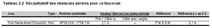
(Q2014-015.1)
Chapter 3 — Paragraph 136
Delete: (2003) of 1.7 m
Replace by: (2013) of 0.6 m
(Q2013-064.1)
Chapter 3 — After paragraph 136
Insert: 136.1 Caution. — Mariners are cautioned that depths may be less due to silting. The approach channel to
the small craft basin is particularly subject to silting. Mariners should contact the marina clubhouse for the latest
information about depths.
(Q2013-064.2)
Chapter 3 — Adjacent to paragraph 136.1, add a caution pictograph.
(Q2013-064.3)
ATL 112 — St. Lawrence River — Cap-Rouge to Montréal and Rivière Richelieu, Third Edition, 2009 —
Chapter 2 — Paragraph 217, after “shortage of pilots, etc.), the”
Delete: Montréal
(Q2014-016.1)
Chapter 2 — Paragraph 217, after “turn by calling”
Delete: “Montréal Traffic”
Replace by: “Québec Traffic”
(Q2014-016.2)
CEN 303 — Welland Canal and Lake Erie, First Edition, 1996 —
Chapter 5 — Delete paragraphs 65 and 66
Replace by: 65 Put-In-Bay, OH, a harbor on the south side of the bay, is used principally for fruit shipments and
excursion business. Ferry service is available to Sandusky, Port Clinton, and Kelleys Island. The approach to the
harbor is marked by lighted and unlighted buoys. A dredged channel, marked by buoys, leads west along the piers on
the south side of the bay.
(C2014-006.01)
CEN 304 — Detroit River, Lake St. Clair, St. Clair River, First Edition, 1996 —
Chapter 1 — Delete paragraph 165
Replace by: 165 Generally, only local and pleasure craft use the channel on the north side of Belle Isle. The lower
entrance is marked by a lighted buoy which marks a 6-foot [1.8-m] shoal that extends 0.5 [0.4] mile from the west
end of Belle Isle. Scott Middle Ground is an extensive shoal area, with depths to 1 foot [0.3 m], between Belle Isle
and the U.S. shore. Natural channels marked by buoys lead north and south of the shoal. The north channel has a
controlling depth of about 18 feet [5.5 m]. Above Scott Middle Ground, a 12-foot [3.7-m] spot is marked on its north
side by a buoy in midchannel north of Belle Isle. The upper entrance to the channel north of Belle Isle is through a
dredged channel marked by lighted and unlighted buoys. A fixed highway bridge (Douglas McArthur Bridge) with a
clearance of 32 feet [9.8 m] crosses from Detroit to the lower end of Belle Isle.
(C2014-007.01)
Chapter 3 — Delete paragraph 97.
(C2014-008.01)
CEN 308 — Rideau Canal and Ottawa River, First Edition, 2003 —
Chapter 9 — Paragraph 142, last line
Add: An area for water-skiing, marked with buoys, is about 70 m from the south shore, between Pont Louis-Bisson
and the overhead cables in Saraguay.
(Q2013-063.1)
LIST OF LIGHTS, BUOYS AND FOG SIGNALS CORRECTIONS
Atlantic |
||||||||||
1685.2 |
Cap-Chat light buoy HA2 |
49 05 56.5 66 41 28.4 |
Fl |
R |
4s |
..... |
..... |
Red spar, marked "HA2". |
Seasonal. Chart:1230 Edn 05/14 (Q14-025) |
|
1685.1 |
Cap-Chat light buoy HA1 |
49 05 58.1 66 41 28.4 |
Fl |
G |
4s |
..... |
13 |
Green spar, marked "HA1". |
Seasonal. Chart:1230 Edn 05/14 (Q14-026) |
|
2124 |
Courbe Pointe du Lac light buoy S21 |
46 15 42.6 72 41 49.1 |
Q |
G |
1s |
..... |
..... |
Green spar, marked "S21". |
Year round. Chart:1312 Edn 05/14 |
|
2309 |
Île à la Pierre light buoy MV6 |
45 43 49.1 73 26 42.1 |
Fl |
R |
4s |
..... |
..... |
Red, marked "MV6". |
Seasonal. Chart: 1310 Edn 05/14 (Q14-017) |
|
|
CANADIAN COAST GUARD MARINE INFORMATION REPORT AND SUGGESTION SHEET. |
Name of Ship or Sender:..................................................................... Date:....................................
Address of Sender:..........................................................................................................................
Street # Street Name
Town / City:.............................. Prov / State:....................... Postal Code / Zip Code: ........................
Tel / Fax / E-mail address of sender (if appropriate):............................................................................
Observation Date:............................................. Time (UTC): ...........................................................
Geographical Position:......................................................................................................................
Coordinate Position: Lat: ............................................... Long:.........................................................
Position Method: q DGPS q GPS with WAAS q GPS q Radar qOther
Horizontal Datum Used: qWGS 84 q NAD 27 q Other
Estimated Position Accuracy:............................................................................................................
Chart #:............................................................ Datum: q NAD 27 q NAD 83
Chart Edition:.................................................... Last Correction applied:............................................
Publications affected: (Quote Volume and page):.................................................................................
*Full details (Attach additional sheets as necessary)............................................................................
Mariners are requested to notify the responsible authorities when new or suspected dangers to navigation are discovered, changes are observed in aids to navigation, or corrections to publications are seen to be necessary.
In the case of new or suspected dangers to navigation, it is important that all details be given in order to aid with future investigations. Items of interest include heights, depths, physical description, type of bottom and equipment method used to position the item. It is helpful to mark details on chart, which will be promptly replaced by the Canadian Hydrographic Service.
Reports should be made to the nearest Marine Communications and Traffic Services Centre (MCTS) and should be confirmed in writing to:
|
Leader, Notices to Mariners Canadian Coast Guard Department of Fisheries and Oceans Montréal, Qc H2Y 2E7 |
In the case of information concerning aids to navigation or the List of Lights, Buoys and Fog Signals. |
|
OR |
|
Dominion Hydrographer Canadian Hydrographic Service Department of Fisheries and Oceans Ottawa, Ontario, K1A 0E6 |
In the case of new or suspected dangers to navigation or where corrections to "Sailing Directions" appear to be necessary. |
Or general questions on Coast Guard programs or services please send an e-mail message to:
info@dfo-mpo.gc.ca (Please include your postal code and e-mail address).