
Archived information
The Standard on Web Usability replaces this content. This content is archived because Common Look and Feel 2.0 Standards have been rescinded.
Archived information is provided for reference, research or recordkeeping purposes. It is not subject to the Government of Canada Web Standards and has not been altered or updated since it was archived.
|
|
Fisheries and Oceans Canada |
Pêches et Océans Canada |
VOL. 36, MONTHLY EDITION NO 05 May 27, 2011 Publication Number 40063779 |
NOTICES TO MARINERS
PUBLICATION EASTERN EDITION |
|||
Published monthly by the
CANADIAN COAST GUARD |
|||
|
|
|||
Page |
|||
| Section 1 |
Safety and General Information | 1 - 4 |
|
| Section 2 |
Chart Corrections | 5 - 15 |
|
| Section 3 |
Corrections to Radio Aids to Marine Navigation | 16 - 18 |
|
| Section 4 |
Sailing Directions and Small Craft Guide Corrections | 19 - 21 |
|
| Section 5 |
List of Lights, Buoys and Fog signals Corrections | 22 - 37 |
|
Maritime Services Directorate Aids to Navigation |
|||
EXPLANATORY NOTES |
Geographical positions refer directly to the graduations of the largest scale Canadian Hydrographic chart unless otherwise indicated. |
Bearings refer to the true compass and are measured clockwise from 000° (North) clockwise to 359°; those relating to lights are from seaward. |
Visibility of lights is that in clear weather. |
Depths - The units used for soundings (metres, fathoms or feet) are stated in the title of each chart. |
Elevations are normally given above Higher High Water, Large Tides unless otherwise indicated. |
Distances may be calculated as follows: |
1 nautical mile = 1 852 metres (6,076.1 feet) 1 statute mile = 1 609.3 metres (5,280 feet) 1 metre = 3.28 feet |
Temporary & Preliminary Notices are indicated by a (T) or a (P) before the chart action and in the section 1. Please note that Nautical charts are not amended by the Canadian Hydrographic Service for Temporary (T) and Preliminary (P) Notices. It is recommended that mariners chart these corrections in pencil. Listing of charts affected by Temporary and Preliminary Notices are revised and promulgated quarterly in Section 1 of the Monthly Edition . |
Please note that, in addition to the temporary and preliminary changes normally advertised as (T) and (P) Notices, there are a few permanent changes to navigational aids that have been advertised as Preliminary Notices to Mariners while charts are being updated for new editions. |
Marine Information Report & Suggestion Sheet - Mariners are requested to notify the responsible authorities when new or suspected dangers to navigation are discovered, changes observed in aids to navigation or corrections to publications are seen to be necessary. Such communications can be made using the Marine Information Report & Suggestion Sheet inserted on the last page of each monthly edition of Notices to Mariners. |
Monthly Notices to Mariners - WEB ACCESS -We are offering a feature where subscribers to our on-line service are able to receive the complete electronic monthly edition of our Notices to Mariners. We are encouraging our clients to visit the http://www.notmar.gc.ca/subscribe/ user-friendly web site to subscribe for this service. Users wishing to receive information updates for their charts can do so by setting up a "User Profile" on the following web page – http://www.notmar.gc.ca/search/mycharts-eng.php?czoxOToibnRtPXN0ZXBfb25lJmxhbmc9ZSI7. This feature permits users to register the nautical charts they currently have in their possession. Registrants are then automatically notified by e-mail when a Notices to Mariners is published concerning these charts. |
Canadian Nautical Charts & Publications - A source list of Canadian Nautical Charts & publications is published in Notice No. 14 of the Notices to Mariners Annual Edition April 2010. The source supply and the prices effective at the time of printing are listed. For current chart edition dates refer to the following web site: http://www.chs-shc.gc.ca/charts-cartes/paper-papier/index-eng.asp |
NOTE: Cette publication est aussi disponible en français. |
CHART CORRECTIONS - SECTION 2 |
|
Corrections to nautical charts will be listed in numeric order by chart number. Each chart correction listed applies only to that particular chart. Related charts, if any, will have their own specific correction listed separately. Users should also refer to CHS Chart 1 Symbols, Abbreviations Terms for additional information pertaining to the correction of charts. The illustration below describes the elements that will comprise a typical Section 2 chart correction. |

ADVISORY |
|
NOTICES TO SHIPPING (WRITTEN AND BROADCAST) |
|
The Canadian Coast Guard is implementing a number of changes to the aids to navigation system in Canada . |
|
These changes are advertised as Notices to Shipping (Broadcast and Written) by the Canadian Coast Guard and are followed up with Notices to Mariners, then charts are updated by hand correction, reprints or new editions. |
|
Mariners are advised that all relevant Written Notices to Shipping should be kept until superseded by Notices to Mariners or through revised charts issued by the Canadian Hydrographic Service. |
|
Written Notices to Shipping are published weekly and are available from local Canadian Coast Guard Offices. |
|
The Canadian Hydrographic Service is reviewing the impact of these changes with the Canadian Coast Guard and together we are preparing an action plan on the issuing of chart revisions. |
|
For further information contact your local Regional Notices to Shipping (Notships) issuing authorities. |
|
|

|
MONTHLY EDITION OF NOTICES TO MARINERS |
WEB ACCESS |
We are offering a feature where subscribers to our on-line service are able to receive the complete electronic monthly edition of our Notices to Mariners. We are encouraging our clients to visit the http://www.notmar.gc.ca /subscribe / web site to subscribe for this service. Users wishing to receive information updates for their charts can do so by setting up a "User Profile" on the following web page http://www.notmar.gc.ca/search/mycharts-eng.php?czoxOToibnRtPXN0ZXBfb25lJmxhbmc9ZSI7 This feature permits users to register the nautical charts they currently have in their possession. Registrants are then automatically notified by e-mail when a Notice to Mariners is published concerning these charts. |
INDEX |
|
CANADIAN HYDROGRAPHIC SERVICE - ANNOUNCEMENT REGARDING CANADIAN HYDROGRAPHIC SERVICE CHART PATCHES |
1 |
CANADIAN HYDROGRAPHIC SERVICE - CUMULATIVE CHART CORRECTIONS |
1 |
CANADIAN HYDROGRAPHIC SERVICE - CURRENT CHART EDITION DATES |
1 |
CANADIAN HYDROGRAPHIC SERVICE - PRINT ON DEMAND CHARTS - CARE AND USE |
1 |
CANADIAN HYDROGRAPHIC SERVICE - TRANSPORT CANADA NAVIGATION SAFETY - ECDIS |
1 |
*504 CANADIAN COAST GUARD PUBLICATION - AMENDMENT TO THE 2011 ANNUAL EDITION OF NOTICES TO MARINERS - NOTICE 32 - POLLUTION - COMPLIANCE WITH CANADIAN REGULATIONS |
3 |
*510 CANADIAN COAST GUARD PUBLICATION - AMENDMENT TO THE RADIO AIDS TO MARINE NAVIGATION (ATLANTIC, ST. LAWRENCE, GREAT LAKES, LAKE WINNIPEG AND EASTERN ARCTIC) PUBLICATION - 2011 |
16 |
*502 CANADIAN HYDROGRAPHIC SERVICE - ELECTRONIC NAVIGATIONAL CHARTS |
2 |
*501 CANADIAN HYDROGRAPHIC SERVICE - NAUTICAL CHARTS |
2 |
*503 CANADIAN HYDROGRAPHIC SERVICE - RASTER DIGITAL CHART (BSB V4) |
3 |
*506 CARAQUET HARBOUR, BAIE DE SHIPPEGAN AND/ET MISCOU HARBOUR- RANGE LIGHTS DISCONTINUED |
4 |
*505 HARBOURS IN THE BAY OF FUNDY/PORTS DANS LA BAIE DE FUNDY SOUTHWEST COAST/CÔTÉ SUD-OUEST - TEMPORARY LIGHT BUOY DISCONTINUED |
4 |
*507 ÎLES DE LA MADELEINE- LIGHTS TO BE DISCONTINUED |
4 |
*508(P) ÎLES DE LA MADELEINE- LIGHTS TO BE DISCONTINUED |
4 |
NUMERICAL INDEX OF CANADIAN CHARTS AFFECTED |
|||||
Chart No. |
Page |
Chart No. |
Page |
Chart No. |
Page |
1312 |
5 |
4591 |
13 |
||
1313 |
5 |
4616 |
13 |
||
1317 |
5,6 |
4624 |
14 |
||
2085 |
6 |
4769 |
2 |
||
4002 |
6 |
4773 |
2 |
||
4003 |
6 |
4821 |
14 |
||
4013 |
6 |
4851 |
14 |
||
4015 |
6 |
4856 |
14 |
||
4022 |
7 |
4857 |
14 |
||
4045 |
7 |
4858 |
14 |
||
4124 |
4 |
L/C 4913 |
4,15 |
||
4211 |
7 |
4950 |
4,15 |
||
4233 |
7 |
5027 |
2 |
||
4234 |
7-9 |
5058 |
2 |
||
4281 |
9 |
6408 |
2 |
||
4307 |
9 |
6409 |
2 |
||
L/C 4320 |
9 |
6425 |
2 |
||
4335 |
9 |
6426 |
2 |
||
4375 |
9 |
6427 |
2 |
||
4384 |
10,11 |
6432 |
2 |
||
4394 |
11,12 |
||||
4405 |
12 |
||||
4406 |
12 |
||||
4452 |
12 |
||||
4455 |
12 |
||||
4456 |
13 |
||||
4486 |
13 |
||||
CANADIAN HYDROGRAPHIC SERVICE - ANNOUNCEMENT REGARDING CANADIAN HYDROGRAPHIC SERVICE CHART PATCHES
Colour Web Patches are free to the mariner, and given the quality of many printers, should reproduce well. They will be available in real time all around the world.
CHS welcomes your feedback on this service at chsinfo@dfo-mpo.gc.ca
CANADIAN HYDROGRAPHIC SERVICE - CUMULATIVE CHART CORRECTIONS
The cumulative Notices to Mariners corrections for charts can now be accessed at
http://www.notmar.gc.ca/search/notmar-eng.php
CANADIAN HYDROGRAPHIC SERVICE - CURRENT CHART EDITION DATES
|
CHART EDITIONS |
|
The three terms described below are used to indicate the publication status of Canadian charts. |
|
NEW CHART - "NEWCHT" |
|
The first publication of a Canadian chart embracing an area not previously charted to the scale shown, or embracing an area different from any existing Canadian chart. |
|
NEW EDITION - "NEWEDT" |
|
A new issue of an existing chart containing amendments essential to navigation in addition to those issued in Notices to Mariners and making existing editions obsolete. |
|
REPRINTS |
|
A new issue of the current edition of a chart incorporating no amendments of navigational significance other than those previously promulgated in Notices to Mariners. It may also contain amendments from other sources provided they are not essential to navigation. Previous printings of the current edition remain in force. |
The current chart edition dates can be accessed at http://www.chs-shc.gc.ca/charts-cartes/paper-papier/index-eng.asp
CANADIAN HYDROGRAPHIC SERVICE - PRINT ON DEMAND CHARTS - CARE AND USE
|
Background By providing nautical charts to the public, the goal of the Canadian Hydrographic Service (CHS) is to provide services for safe navigation in a fiscally responsible manner. As a result, CHS continues to expand its portfolio of nautical paper charts that are printed using Print On Demand (POD) technology. These charts are easily recognized by their whiter paper and the coloured logo of the Canadian Hydrographic Service. This new technology enables CHS to print charts in a more efficient manner while enhancing chart content through being able to quickly add new and important information. POD technology provides customers with up-to-date charts without the historical hand-drawn corrections or glued-on patches. Additionally, this technology eliminates out-of-stock situations which arise with the traditional printing and warehousing methods. In the event of a national emergency, CHS can respond to the appropriate authorities with best available information very quickly. Care of Your POD Chart CHS encourages its customers to handle the POD charts more carefully than the traditional lithographic charts. When plotting information on POD charts, use HB pencils and apply limited pressure. Testing has suggested that an Indian gum eraser is more effective than alternatives when used on the product. This eraser is also suitable for charts printed using lithographic processes. |
CANADIAN HYDROGRAPHIC SERVICE - TRANSPORT CANADA NAVIGATION SAFETY - ECDIS
|
Mariners are advised that ECDIS may not display some isolated shoal depths when operating in "base or standard display" mode. Route planning and monitoring alarms for these shoal depths may not always be activated. To ensure safe navigation and to confirm that a planned route is clear of such dangers, mariners should visually inspect the planned route and any deviations from it using ECDIS configured to display "all data". The automated voyage planning check function should not be solely relied upon. |
*501 CANADIAN HYDROGRAPHIC SERVICE - NAUTICAL CHARTS
|
CHARTS |
MAIN TITLE |
SCALE |
PUBLISHED |
CAT# |
PRICE |
|
New Charts |
All temporary and preliminary notices affecting the previous versions of the following chart(s) (is / are) now cancelled. For any outstanding notices please consult section 2 of this edition. | ||||
|
5027 |
Murphy Head to / aux Button Islands |
1:200000 |
27-AUG-2010 |
1 |
$20.00 |
|
5058 |
North Head to / à Murphy Head |
1:100000 |
25-JUN-2010 |
1 |
$20.00 |
|
New Editions |
All temporary and preliminary notices affecting the previous versions of the following chart(s) (is / are) now cancelled. For any outstanding notices please consult section 2 of this edition. | ||||
|
6408 |
Cache Island to / à Rabbitskin River Kilometre / Kilomètre 233 / 301 |
1:50000 |
31-DEC-2010 |
4 |
$12.00 |
|
6409 |
Rabbitskin River to / à Fort Simpson Kilometre / Kilomètre 300 / 330 |
---- |
31-DEC-2010 |
4 |
$12.00 |
|
6425 |
Travaillant River to / à Adam Cabin Creek Kilometre / Kilomètre 1325 / 1400 |
1:50000 |
11-FEB-2011 |
4 |
$12.00 |
|
6426 |
Adam Cabin Creek to / à Point Separation - Kilometre / Kilomètre 1400 / 1480 |
1:50000 |
11-FEB-2011 |
4 |
$12.00 |
|
6427 |
Point Separation to / au Aklavik Channel Kilometre / Kilomètre 1480 / 1540 |
1:50000 |
11-FEB-2011 |
4 |
$12.00 |
|
6432 |
Kilometre / Kilomètre 1500 to / à Inuvik East Channel |
---- |
11-FEB-2011 |
4 |
$12.00 |
|
|
|
|
|
|
|
|
Charts Permanently Withdrawn |
All temporary and preliminary notices affecting the following chart(s) (is / are) now cancelled. For any outstanding notices please consult section 2 of this edition. | ||||
|
4769 |
Nachvak Bay to / à Saglek Bay Entrance |
|
|
|
|
|
4773 |
Vicinity of / Environs de Cape Chidley |
|
|
|
|
|
New Publications |
|
|
|
|
|
|
|
Radio Aids to Marine Navigation (Atlantic, St. Lawrence, Great Lakes, Lake Winnipeg and Eastern Arctic) |
|
01-APR-2011 |
|
$18.95 |
|
|
Aides Radio à la Navigation Maritime (Atlantique, St-Laurent, Grands Lacs, Lac Winnipeg et l'Arctique de l'est) |
|
01-APR-2011 |
|
$18.95 |
|
|
Radio Aids to Marine Navigation (Pacific and Western Arctic) |
|
01-APR-2011 |
|
$14.95 |
|
|
Aides Radio à la Navigation Maritime (Pacifique et l'Arctique de l'ouest) |
|
01-APR-2011 |
|
$14.95 |
|
|
Notices to Mariners 1 to 46 - Annual Edition - April 2011 |
|
01-APR-2011 |
|
$22.95 |
|
|
Avis aux navigateurs 1 à 46 - Édition annuelle - Avril 2011 |
|
01-APR-2011 |
|
$22.95 |
*502 CANADIAN HYDROGRAPHIC SERVICE - ELECTRONIC NAVIGATIONAL CHARTS
|
RELEASED PRODUCTS |
|
|
S-57 ENC NUMBER |
CHART TITLE |
|
CA573283 |
Approaches to / Approches à Parry Sound North |
|
CA473332 |
Cambridge Bay |
|
CA373338 |
Lambert Channel and / et Cache Point Channel |
|
CA473342 |
Kugluktuk |
|
CA376083 |
Taylors Head to / à Shut-in Island |
|
CA476085 |
Port Harmon and Approaches / et les approches |
|
CA276090 |
Sable Island Bank / Banc de I'Île de Sable to / au St. Pierre Bank / Banc de Saint Pierre |
|
CA376102 |
Barren Island to / à Taylors Head |
|
CA576143 |
Iona and / et Grand Narrows |
|
CA476196 |
Head Harbour |
|
CA476197 |
Hubbards Cove |
|
CA476202 |
Cape Lahave to / à Liverpool Bay |
|
CA476214 |
Sebaskachu Bay |
|
CA476216 |
South Green Island to Ticoralak Island |
|
CA476220 |
Carrington Island to Etagaulet Bay |
|
CA476221 |
St. Peter's Bay to Strait of Canso |
|
CA476281 |
Strait of Canso and / et Southern Approaches / et les approches sud |
|
CA376368 |
Cape Harrigan to / aux Kitlit Islands |
|
CA476494 |
Sandwich Bay |
|
CA476495 |
Continuation A - Sandwich Bay |
|
CA476600 |
Akuliakatak Peninsula to Satosoak Island |
|
CA576629 |
Maiden Arm, Spring Inlets and Approaches |
|
CA476639 |
Black Island to / à Little Denier Island |
|
CA576654 |
Voisey Bay Wharf |
|
CA476673 |
Cape Daly to / à Amiktok Island |
|
CA476682 |
Cape Kakkiviak to Duck Islands |
|
CA276801 |
Yarmouth to / à Halifax |
|
CA476804 |
Bacalhao Island to Black Island |
|
CA376807 |
Bonavista Bay, Southern Portion |
|
CA376819 |
Approaches to Hamilton Inlet (Northern Portion) |
|
CA376820 |
Approaches to Hamilton Inlet (Southern Portion) |
|
CA479014 |
Batiscan au / to Lac Saint-Pierre |
|
CA579016 |
Port de Bécancour |
|
CA570102 |
Pedder Bay |
*503 CANADIAN HYDROGRAPHIC SERVICE - RASTER DIGITAL CHART (BSB V4)
|
CHART |
MAIN TITLE |
|
PUBLISHED |
|
|
|
New Edition |
All temporary and preliminary notices affecting the previous versions of the following chart(s) (is / are) now cancelled. For any outstanding notices please consult section 2 of this edition. | ||||
|
R/M2085 |
Toronto Harbour |
|
04-MAR-2011 |
| |
*504 CANADIAN COAST GUARD PUBLICATION - AMENDMENT TO THE 2011 ANNUAL EDITION OF NOTICES TO MARINERS - NOTICE 32 - POLLUTION - COMPLIANCE WITH CANADIAN REGULATIONS
|
Amend: Notice 32 - Page E32-1 Any discharge, or the danger of a discharge, of any pollutant must be reported by the quickest means available and in the manner prescribed in the Guidelines for Reporting Incidents Involving Dangerous Goods, Harmful Substances and/or Marine Pollutants, TP 9834 or International Maritime Organization Resolution A.85(120) as amended. To ReaTo read: Any discharge, or the danger of a discharge, of any pollutant must be reported by the quickest means available and in the manner prescribed in the Guidelines for Reporting Incidents Involving Dangerous Goods, Harmful Substances and/or Marine Pollutants, TP 9834 or International Maritime Organization Resolution A.851(20) as amended. |
*505 HARBOURS IN THE BAY OF FUNDY/PORTS DANS LA BAIE DE FUNDY SOUTHWEST COAST/CÔTÉ SUD-OUEST - TEMPORARY LIGHT BUOY DISCONTINUED
|
Reference: Notice 421(T)/2011 is now cancelled (Chart: 4124) (F2011-100, 107) |
*506 CARAQUET HARBOUR, BAIE DE SHIPPEGAN AND/ET MISCOU HARBOUR- RANGE LIGHTS DISCONTINUED
|
Reference: Notice 1107(P)/2010 is now cancelled (Chart: L/C 4913) (G2011-094, 095) |
*507 ÎLES DE LA MADELEINE- LIGHTS TO BE DISCONTINUED
|
Reference: Notice 1210(P)/2010 is now cancelled (Chart: 4950). (Q2011-069) |
*508(P) ÎLES DE LA MADELEINE- LIGHTS TO BE DISCONTINUED
|
Reference: Chart 4950 The Canadian Coast Guard intends to permanently discontinue the following aids to navigation: Île du Havre-aux-Maisons light (Cap Alright) (L.L. 1496) (47° 23' 27".2N 61°46' 24.6" W) Île du Cap-aux-Meules light (Cap du Phare) (L.L. 1488) (47° 23' 05".1N 61°57' 33.1" W) Île du Havre-Aubert light (Pointe sud) (L.L. 1500) (47° 12' 44".8N 61°58' 18.9" W) Île d'Entrée light (Pointe de la light) (L.F. 1509) (47° 16' 03".5N 61°42' 18" W) Comments on this action are solicited from mariners and other interested parties. Comments should be directed to the following by the end of August 2011 : Daniel Lefebvre Regional Superintendent, Aids to Navigation, Canadian Coast Guard, 101 boul. Champlain, Québec, QC. G1K 7Y7 Email: daniel.lefebvre@dfo-mpo.gc.ca., Telephone (418) 648-7450, Fax: (418) 649-6690, Any objections must state the facts on which they are based and should include supporting information on safety, commerce and public benefit. (Q2011-069) |
CHART CORRECTIONS
1312 - Lac Saint-Pierre - New Edition - 08-JUN-2007 - NAD 1983
|
13-MAY-2011 |
LNM/D. 01-APR-2011 |
|
|
Replace |
green port hand lighted spar buoy Fl G, marked S123 with green port hand lighted pillar buoy Fl G, marked S123 (See Chart No. 1, Q23) |
46°04'57.0"N 073°00'37.5"W |
|
(Q2011052) LL(2173) DFO(6408351-01) | ||
|
This notice might affect Electronic Navigational Chart: CA479129 | ||
1313 - Batiscan au / to Lac Saint-Pierre - New Edition - 02-FEB-2007 - NAD 1983
|
20-MAY-2011 |
LNM/D. 13-MAY-2011 |
||
|
Delete |
depth of 13 metres 2 decimetres (See Chart No. 1, I10) |
46°16'54.4"N 072°36'12.8"W |
|
|
DFO(6408324-01) | |||
|
This notice might affect Electronic Navigational Chart: CA479014 | |||
|
Add |
depth of 12 metres 3 decimetres (See Chart No. 1, I10) |
46°16'52.3"N 072°36'17.0"W |
|
|
DFO(6408324-02) | |||
|
This notice might affect Electronic Navigational Chart: CA479014 | |||
|
Add |
depth of 9 metres 1 decimetre (See Chart No. 1, I10) |
46°16'43.4"N 072°36'33.5"W |
|
|
DFO(6408324-03) | |||
|
This notice might affect Electronic Navigational Chart: CA479014 | |||
|
13-MAY-2011 |
LNM/D. 07-JAN-2011 | ||
|
Reposition |
green port hand lighted pillar buoy Fl G, marked C71 (See Chart No. 1, Qg) |
from 46°17'25.9"N 072°34'59.5"W | |
|
to 46°17'14.2"N 072°35'22.0"W | |||
|
(Q2011044) LL(2109) DFO(6408330-01) | |||
|
This notice might affect Electronic Navigational Chart: CA479014 | |||
|
Add |
depth of 8 metres (See Chart No. 1, I10) |
46°26'08.9"N 072°19'43.7"W |
|
|
DFO(6408350-01) | |||
|
This notice might affect Electronic Navigational Chart: CA479014 | |||
1317 - Sault-au-Cochon à / to Québec - Sheet 1 - New Edition - 04-JUL-2008 - NAD 1983
|
13-MAY-2011 |
LNM/D. 22-APR-2011 |
|
|
Add |
depth of 9 metres 5 decimetres (See Chart No. 1, I10) |
47°06'10.1"N 070°42'52.0"W |
|
DFO(6408358-01) | ||
|
This notice might affect Electronic Navigational Chart: CA479025 | ||
|
Delete |
depth of 10 metres 6 decimetres (See Chart No. 1, I10) |
47°06'04.0"N 070°42'50.6"W |
|
DFO(6408358-02) | ||
|
This notice might affect Electronic Navigational Chart: CA479025 | ||
|
Add |
depth of 10 metres 3 decimetres (See Chart No. 1, I10) |
47°06'04.9"N 070°42'55.2"W |
|
DFO(6408358-03) | ||
|
This notice might affect Electronic Navigational Chart: CA479025 | ||
|
Add |
depth of 11 metres 3 decimetres (See Chart No. 1, I10) |
47°04'22.4"N 070°43'38.5"W |
|
DFO(6408358-04) | ||
|
This notice might affect Electronic Navigational Chart: CA479025 | ||
|
Delete |
depth of 13 metres 1 decimetre (See Chart No. 1, I10) |
47°01'52.4"N 070°45'50.8"W |
|
DFO(6408360-01) | ||
|
This notice might affect Electronic Navigational Chart: CA479025 | ||
|
Add |
depth of 12 metres 1 decimetre (See Chart No. 1, I10) |
47°01'52.5"N 070°45'51.6"W |
|
DFO(6408360-02) | ||
|
This notice might affect Electronic Navigational Chart: CA479025 | ||
2085 - Toronto Harbour - New Edition - 04-MAR-2011 - NAD 1983
|
06-MAY-2011 | ||
|
Replace |
green, red and green port bifurcation lighted pillar buoy FlG, marked TAB with green, red and green port bifurcation lighted pillar buoy Fl(2+1)G 6s, marked TAB (See Chart No. 1, Qj) |
43°37'34.6"N 079°24'45.4"W |
|
(B2011004) LL(513.1) DFO(6603678-01) | ||
|
This notice might affect Electronic Navigational Chart: CA573008 | ||
|
Replace |
green, red and green port bifurcation lighted pillar buoy FlG, marked TCB with green, red and green port bifurcation lighted pillar buoy Fl(2+1)G 6s, marked TCB (See Chart No. 1, Qj) |
43°37'46.9"N 079°24'18.7"W |
|
(B2011005) LL(513.2) DFO(6603679-01) | ||
|
This notice might affect Electronic Navigational Chart: CA573008 | ||
4002 - Golfe du Saint-Laurent / Gulf of St. Lawrence - New Edition - 27-DEC-1991 - NAD 1927
|
06-MAY-2011 |
LNM/D. 24-SEP-2010 |
|
|
Amend |
Fl 17M to read Fl 15M against light (See Chart No 1 P16) |
46°02'04.3"N 059°40'33.7"W |
|
(G2011058) LL(767) DFO(6305358-01) | ||
|
This notice might affect Electronic Navigational Chart: CA179172 | ||
4003 - Cape Breton to / à Cape Cod - New Edition - 21-MAR-2003 - NAD 1983
|
06-MAY-2011 |
LNM/D. 25-MAR-2011 |
|
|
Amend |
Fl 17M to read Fl 15M against light (See Chart No 1 P16) |
46°02'04.3"N 059°40'33.7"W |
|
(G2011058) LL(767) DFO(6305358-01) | ||
|
This notice might affect Electronic Navigational Chart: CA176140 | ||
4013 - Halifax to / à Sydney - New Edition - 06-SEP-2002 - NAD 1983
|
06-MAY-2011 |
LNM/D. 18-MAR-2011 |
|
|
Amend |
Fl 15s 64ft 17M to read Fl 3s 64ft 15M against light (See Chart No 1 P16) |
46°02'04.3"N 059°40'33.7"W |
|
(G2011058) LL(767) DFO(6305358-01) | ||
4015 - Sydney to / à Saint-Pierre - New Edition - 28-MAR-2003 - NAD 1983
|
06-MAY-2011 |
LNM/D. 18-MAR-2011 |
|
|
Amend |
Fl 15s 64ft 17M to read Fl 3s 64ft 15M against light (See Chart No 1 P16) |
46°02'04.3"N 059°40'33.7"W |
|
(G2011058) LL(767) DFO(6305358-01) | ||
4022 - Cabot Strait and Approaches / Détroit de Cabot et les approches, Scatarie Island to / à Anticosti Island / Île D'Anticosti - New Edition - 17-JAN-2003 - NAD 1983
|
06-MAY-2011 |
LNM/D. 18-MAR-2011 |
|
|
Amend |
Fl 15s 64ft 17M to read Fl 3s 64ft 15M against light (See Chart No 1 P16) |
46°02'04.3"N 059°40'33.7"W |
|
(G2011058) LL(767) DFO(6305358-01) | ||
|
This notice might affect Electronic Navigational Chart: CA276271 | ||
4045 - Sable Island Bank / Banc de I'Île de Sable to / au St. Pierre Bank /Banc de Saint Pierre - New Edition - 10-OCT-2003 - NAD 1983
|
06-MAY-2011 |
LNM/D. 11-FEB-2011 |
|
|
Amend |
Fl 15s 19m 17M to read Fl 3s 19m 15M against light (See Chart No 1 P16) |
46°02'04.3"N 059°40'33.7"W |
|
(G2011058) LL(767) DFO(6305358-01) | ||
4211 - Cape Lahave to / à Liverpool Bay - New Edition - 20-JUN-2003 - NAD 1983
|
20-MAY-2011 |
LNM/D. 05-MAR-2010 |
|
|
Delete |
depth of 4 fathoms, 4 feet (See Chart No. 1, I10) |
44°09'40.2"N 064°28'33.8"W |
|
DFO(6305440-01) | ||
|
Delete |
depth of 1 fathom, 5 feet (See Chart No. 1, I10) |
44°09'39.7"N 064°28'42.2"W |
|
DFO(6305440-02) | ||
|
Add |
depth of 0 fathoms, 4 feet (See Chart No. 1, I10) |
44°09'40.4"N 064°28'40.4"W |
|
DFO(6305440-03) | ||
|
Add |
depth of 0 fathoms, 2 feet (See Chart No. 1, I10) |
44°09'35.3"N 064°28'41.4"W |
|
DFO(6305440-04) | ||
|
Delete |
depth of 5 fathoms, 2 feet (See Chart No. 1, I10) |
44°09'35.4"N 064°28'36.9"W |
|
DFO(6305440-05) | ||
4233 - Cape Canso to / à Country Island - New Chart - 11-JAN-1991 - NAD 1983
|
06-MAY-2011 |
LNM/D. 25-FEB-2011 |
||
|
Amend |
FlR to read LFlR against light (See Chart No 1 P16) |
45°16'58.1"N 061°01'42.6"W |
|
|
(G2011057) LL(663.2) DFO(6305344-01) | |||
|
This notice might affect Electronic Navigational Chart: CA376067 | |||
|
13-MAY-2011 |
LNM/D. 06-MAY-2011 | ||
|
Reposition |
red and white fairway lighted pillar whistle buoy Mo(A), WHIS marked PC (See Chart No. 1, Qh) |
from 45°22'12.7"N 060°59'49.3"W | |
|
to 45°21'43.0"N 060°59'41.5"W | |||
|
(G2011098) LL(682) DFO(6305420-01) | |||
|
This notice might affect Electronic Navigational Chart: CA376067 | |||
4234 - Port Bickerton - New Chart - 10-APR-1987 - NAD 1983
|
27-MAY-2011 |
LNM/D. 14-JAN-2011 |
|
|
Delete |
depth of 2 metres, 1 decimetre (See Chart No. 1, I10) |
45°06'18.1"N 061°43'22.9"W |
|
DFO(6305441-01) | ||
|
This notice might affect Electronic Navigational Chart: CA576110 | ||
|
Add |
depth of 1 metre, 8 decimetres (See Chart No. 1, I10) |
45°06'19.0"N 061°43'24.0"W |
|
DFO(6305441-02) | ||
|
This notice might affect Electronic Navigational Chart: CA576110 | ||
|
Add |
depth of 2 metres (See Chart No. 1, I10) |
45°06'14.4"N 061°43'21.9"W |
|
DFO(6305441-03) | ||
|
This notice might affect Electronic Navigational Chart: CA576110 | ||
|
Add |
depth of 0 metres, 9 decimetres (See Chart No. 1, I10) |
45°06'13.3"N 061°43'25.0"W |
|
DFO(6305441-04) | ||
|
This notice might affect Electronic Navigational Chart: CA576110 | ||
|
Add |
depth of 1 metre, 9 decimetres (See Chart No. 1, I10) |
45°06'17.1"N 061°43'22.5"W |
|
DFO(6305441-05) | ||
|
This notice might affect Electronic Navigational Chart: CA576110 | ||
|
Add |
depth of 3 metres, 3 decimetres (See Chart No. 1, I10) |
45°05'58.3"N 061°43'06.2"W |
|
DFO(6305441-06) | ||
|
This notice might affect Electronic Navigational Chart: CA576110 | ||
|
Delete |
depth of 2 metres, 9 decimetres (See Chart No. 1, I10) |
45°05'39.3"N 061°43'29.6"W |
|
DFO(6305442-01) | ||
|
This notice might affect Electronic Navigational Chart: CA576110 | ||
|
Delete |
depth of 2 metres, 7 decimetres (See Chart No. 1, I10) |
45°05'33.4"N 061°42'58.6"W |
|
DFO(6305442-02) | ||
|
This notice might affect Electronic Navigational Chart: CA576110 | ||
|
Add |
depth of 0 metres, 2 decimetres (See Chart No. 1, I10) |
45°05'44.2"N 061°43'40.1"W |
|
DFO(6305442-03) | ||
|
This notice might affect Electronic Navigational Chart: CA576110 | ||
|
Add |
depth of 1 metre, 6 decimetres (See Chart No. 1, I10) |
45°05'39.0"N 061°43'31.2"W |
|
DFO(6305442-04) | ||
|
This notice might affect Electronic Navigational Chart: CA576110 | ||
|
Add |
depth of 2 metres, 3 decimetres (See Chart No. 1, I10) |
45°05'37.5"N 061°43'25.9"W |
|
DFO(6305442-05) | ||
|
This notice might affect Electronic Navigational Chart: CA576110 | ||
|
Add |
awash 0 metres (See Chart No. 1, Kb) |
45°05'39.8"N 061°43'23.3"W |
|
DFO(6305442-06) | ||
|
This notice might affect Electronic Navigational Chart: CA576110 | ||
|
Add |
depth of 1 metre, 8 decimetres (See Chart No. 1, I10) |
45°05'35.8"N 061°43'13.2"W |
|
DFO(6305442-07) | ||
|
This notice might affect Electronic Navigational Chart: CA576110 | ||
|
Add |
depth of 2 metres (See Chart No. 1, I10) |
45°05'33.1"N 061°42'58.8"W |
|
DFO(6305442-08) | ||
|
This notice might affect Electronic Navigational Chart: CA576110 | ||
|
Add |
depth of 1 metre, 9 decimetres (See Chart No. 1, I10) |
45°05'35.2"N 061°42'57.0"W |
|
DFO(6305442-09) | ||
|
This notice might affect Electronic Navigational Chart: CA576110 | ||
|
Add |
depth of 1 metre, 2 decimetres (See Chart No. 1, I10) |
45°05'32.6"N 061°42'52.3"W |
|
DFO(6305442-10) | ||
|
This notice might affect Electronic Navigational Chart: CA576110 | ||
4281 - Canso Harbour and Approaches / et les approches - New Edition - 16-NOV-2001 - NAD 1983
|
13-MAY-2011 |
LNM/D. 10-DEC-2010 | ||
|
Reposition |
red and white fairway lighted pillar whistle buoy Mo(A), WHIS marked PC (See Chart No. 1, Qh) |
from 45°22'14.1"N 060°59'50.2"W | |
|
to 45°21'43.0"N 060°59'41.5"W | |||
|
(G2011098) LL(682) DFO(6305420-01) | |||
|
This notice might affect Electronic Navigational Chart: CA576527 | |||
4307 - Canso Harbour to / au Strait of Canso - New Edition - 04-JAN-2008 - NAD 1983
|
13-MAY-2011 |
LNM/D. 10-DEC-2010 | ||
|
Reposition |
red and white fairway lighted pillar whistle buoy Mo(A), WHIS marked PC (See Chart No. 1, Qh) |
from 45°22'14.1"N 060°59'50.2"W | |
|
to 45°21'43.0"N 060°59'41.5"W | |||
|
(G2011098) LL(682) DFO(6305420-01) | |||
|
This notice might affect Electronic Navigational Chart: CA476277 | |||
L/C4320 - Egg Island to / à West Ironbound Island - New Edition - 26-SEP-1997 - NAD 1983
|
13-MAY-2011 |
LNM/D. 18-FEB-2011 |
|
|
Add |
depth of 1 fathom, 4 feet (See Chart No. 1, I10) |
44°13'53.2"N 064°22'25.6"W |
|
DFO(6305432-17) | ||
|
Delete |
depth of 4 fathoms (See Chart No. 1, I10) |
44°13'49.6"N 064°22'34.0"W |
|
DFO(6305432-18) | ||
4335 - Strait of Canso and Approaches / et les approches - New Edition - 04-JAN-2008 - NAD 1983
|
13-MAY-2011 |
LNM/D. 01-OCT-2010 | ||
|
Reposition |
red and white fairway lighted pillar whistle buoy Mo(A), WHIS marked PC (See Chart No. 1, Qh) |
from 45°22'14.1"N 060°59'50.2"W | |
|
to 45°21'43.0"N 060°59'41.5"W | |||
|
(G2011098) LL(682) DFO(6305420-01) | |||
4375 - Guyon Island to / à Flint Island - New Edition - 11-OCT-2002 - NAD 1983
|
06-MAY-2011 |
LNM/D. 11-FEB-2011 |
|
|
Amend |
Fl 15s 64ft 17M to read Fl 3s 64ft 15M against light (See Chart No 1 P16) |
46°02'04.3"N 059°40'33.7"W |
|
(G2011058) LL(767) DFO(6305358-01) | ||
|
This notice might affect Electronic Navigational Chart: CA376303 | ||
4384 - Pearl Island to / à Cape La Have - New Edition - 10-JAN-2003 - NAD 1983
|
13-MAY-2011 |
LNM/D. 04-JUN-2010 |
|
|
Delete |
depth of 5 metres, 2 decimetres (See Chart No. 1, I10) |
44°14'32.1"N 064°22'15.4"W |
|
DFO(6305432-06) | ||
|
This notice might affect Electronic Navigational Chart: CA476664 | ||
|
Delete |
depth of 2 metres, 7 decimetres (See Chart No. 1, I10) |
44°14'06.0"N 064°22'04.0"W |
|
DFO(6305432-07) | ||
|
This notice might affect Electronic Navigational Chart: CA476664 | ||
|
Delete |
depth of 5 metres, 5 decimetres (See Chart No. 1, I10) |
44°13'51.5"N 064°22'27.2"W |
|
DFO(6305432-11) | ||
|
This notice might affect Electronic Navigational Chart: CA476664 | ||
|
Add |
depth of 3 metres, 7 decimetres (See Chart No. 1, I10) |
44°13'35.0"N 064°22'47.6"W |
|
DFO(6305432-12) | ||
|
This notice might affect Electronic Navigational Chart: CA476664 | ||
|
Add |
depth of 3 metres (See Chart No. 1, I10) |
44°14'31.6"N 064°22'14.6"W |
|
DFO(6305432-14) | ||
|
This notice might affect Electronic Navigational Chart: CA476664 | ||
|
Add |
depth of 1 metre, 5 decimetres (See Chart No. 1, I10) |
44°14'05.9"N 064°22'04.2"W |
|
DFO(6305432-15) | ||
|
This notice might affect Electronic Navigational Chart: CA476664 | ||
|
Add |
depth of 4 metres, 3 decimetres (See Chart No. 1, I10) |
44°14'47.2"N 064°21'55.5"W |
|
DFO(6305432-16) | ||
|
This notice might affect Electronic Navigational Chart: CA476664 | ||
|
Add |
depth of 3 metres (See Chart No. 1, I10) |
44°13'53.2"N 064°22'25.6"W |
|
DFO(6305432-17) | ||
|
This notice might affect Electronic Navigational Chart: CA476664 | ||
|
20-MAY-2011 |
LNM/D. 13-MAY-2011 |
|
|
Delete |
depth of 8 metres, 5 decimetres (See Chart No. 1, I10) |
44°09'40.2"N 064°28'34.8"W |
|
DFO(6305440-01) | ||
|
This notice might affect Electronic Navigational Chart: CA476664 | ||
|
Delete |
depth of 3 metres, 4 decimetres (See Chart No. 1, I10) |
44°09'39.2"N 064°28'43.0"W |
|
DFO(6305440-02) | ||
|
This notice might affect Electronic Navigational Chart: CA476664 | ||
|
Add |
depth of 1 metre, 1 decimetre (See Chart No. 1, I10) |
44°09'40.4"N 064°28'40.3"W |
|
DFO(6305440-03) | ||
|
This notice might affect Electronic Navigational Chart: CA476664 | ||
|
Add |
depth of 0 metres, 6 decimetres (See Chart No. 1, I10) |
44°09'35.1"N 064°28'41.4"W |
|
DFO(6305440-04) | ||
|
This notice might affect Electronic Navigational Chart: CA476664 | ||
4394 - LaHave River - West Ironbound Island to / à Riverport - New Edition - 26-JUL-2002 - NAD 1983
|
13-MAY-2011 |
LNM/D. 01-MAY-2009 |
|
|
Delete |
depth of 21 feet (See Chart No. 1, I10) |
44°13'34.8"N 064°22'49.3"W |
|
DFO(6305432-01) | ||
|
Delete |
depth of 21 feet (See Chart No. 1, I10) |
44°13'36.3"N 064°22'46.8"W |
|
DFO(6305432-02) | ||
|
Delete |
depth of 18 feet (See Chart No. 1, I10) |
44°13'35.1"N 064°22'47.4"W |
|
DFO(6305432-03) | ||
|
Delete |
depth of 20 feet (See Chart No. 1, I10) |
44°13'37.4"N 064°22'44.9"W |
|
DFO(6305432-04) | ||
|
Delete |
depth of 21 feet (See Chart No. 1, I10) |
44°14'32.1"N 064°22'14.5"W |
|
DFO(6305432-05) | ||
|
Delete |
depth of 9 feet (See Chart No. 1, I10) |
44°14'04.6"N 064°22'06.6"W |
|
DFO(6305432-07) | ||
|
Delete |
depth of 18 feet (See Chart No. 1, I10) |
44°14'45.0"N 064°21'57.8"W |
|
DFO(6305432-08) | ||
|
Delete |
depth of 17 feet (See Chart No. 1, I10) |
44°13'53.3"N 064°22'25.6"W |
|
DFO(6305432-09) | ||
|
Delete |
depth of 16 feet (See Chart No. 1, I10) |
44°13'51.9"N 064°22'25.5"W |
|
DFO(6305432-10) | ||
|
Add |
depth of 12 feet (See Chart No. 1, I10) |
44°13'34.8"N 064°22'48.5"W |
|
DFO(6305432-12) | ||
|
Add |
depth of 15 feet (See Chart No. 1, I10) |
44°13'36.1"N 064°22'47.4"W |
|
DFO(6305432-13) | ||
|
Add |
depth of 10 feet (See Chart No. 1, I10) |
44°14'32.0"N 064°22'13.8"W |
|
DFO(6305432-14) | ||
|
Add |
depth of 5 feet (See Chart No. 1, I10) |
44°14'04.3"N 064°22'06.7"W |
|
DFO(6305432-15) | ||
|
Add |
depth of 14 feet (See Chart No. 1, I10) |
44°14'45.7"N 064°21'56.5"W |
|
DFO(6305432-16) | ||
|
Add |
depth of 10 feet (See Chart No. 1, I10) |
44°13'53.2"N 064°22'25.6"W |
|
DFO(6305432-17) | ||
4405 - Pictou Island to / aux Tryon Shoals - New Edition - 21-FEB-2003 - NAD 1983
|
13-MAY-2011 |
LNM/D. 18-MAR-2011 |
|
|
Add |
red and white fairway lighted spar buoy Mo(A), marked NX (See Chart No. 1, Qh) |
46°10'35.2"N 063°28'00.6"W |
|
(G2011114) LL(1009.11) DFO(6305435-01) | ||
|
Delete |
red starboard hand lighted pillar buoy FlR, marked NX2 (See Chart No 1 Qf) |
46°10'35.2"N 063°28'00.6"W |
|
(G2011115) LL(1009.1) DFO(6305436-01) | ||
4405 - Victoria Harbour - New Edition - 21-FEB-2003 - NAD 1983
|
13-MAY-2011 |
LNM/D. 18-MAR-2011 |
|
|
Add |
red and white fairway lighted spar buoy Mo(A), marked NX (See Chart No. 1, Qh) |
46°10'35.2"N 063°28'00.6"W |
|
(G2011114) LL(1009.11) DFO(6305435-01) | ||
|
Delete |
red starboard hand lighted spar buoy FlR, marked NX2 (See Chart No 1 Qf) |
46°10'35.2"N 063°28'00.6"W |
|
(G2011115) LL(1009.1) DFO(6305436-01) | ||
|
Add |
red starboard hand lighted pillar buoy FlR, marked NX4 (See Chart No. 1, Qf) |
46°11'26.2"N 063°28'31.9"W |
|
(G2011116) LL(1009.12) DFO(6305437-01) | ||
4406 - Tryon Shoals to / à Cape Egmont - New Edition - 27-FEB-1998 - NAD 1983
|
13-MAY-2011 |
LNM/D. 03-DEC-2010 |
|
|
Add |
red and white fairway lighted spar buoy Mo(A), marked NX (See Chart No. 1, Qh) |
46°10'35.2"N 063°28'00.6"W |
|
(G2011114) LL(1009.11) DFO(6305435-01) | ||
|
Delete |
red starboard hand lighted pillar buoy FlR, marked NX2 (See Chart No 1 Qf) |
46°10'35.2"N 063°28'00.6"W |
|
(G2011115) LL(1009.1) DFO(6305436-01) | ||
4452 - Baie Johan-Beetz et / and Baie Piashti - Sheet 1 - New Edition - 15-AUG-2008 - NAD 1983
|
06-MAY-2011 |
LNM/D. 08-APR-2011 |
|
|
Delete |
orange beacon BnOr (See Chart No. 1, Q81, Qb) |
50°16'11.6"N 062°46'27.8"W |
|
(Q2011028) DFO(6408301-01) | ||
4455 - Baie Washtawouka à / to Baie Piashti - New Edition - 14-OCT-2005 - NAD 1983
|
06-MAY-2011 | ||
|
Delete |
orange beacon BnOr (See Chart No. 1, Q81, Qb) |
50°16'11.6"N 062°46'27.8"W |
|
(Q2011028) DFO(6408301-01) | ||
4456 - Baie Piashti à / to Petite Île au Marteau - New Edition - 26-MAR-2004 - NAD 1983
|
06-MAY-2011 |
LNM/D. 31-DEC-2010 |
|
|
Delete |
orange beacon BnOr (See Chart No. 1, Q81, Qb) |
50°16'11.6"N 062°46'27.8"W |
|
(Q2011028) DFO(6408301-01) | ||
4486 - Baie des Chaleurs / Chaleur Bay - New Edition - 19-FEB-1999 - NAD 1983
|
13-MAY-2011 |
LNM/D. 01-APR-2011 |
|
|
Delete |
front range/leading light FY (See Chart No. 1, P20.2) |
47°52'55.1"N 064°34'58.9"W |
|
(G2011094) LL(1268) DFO(6305412-01) | ||
|
This notice might affect Electronic Navigational Chart: CA376187 | ||
|
Delete |
rear range/leading light FY with leading line (See Chart No. 1, P20.2) |
47°52'47.4"N 064°34'39.7"W |
|
(G2011095) LL(1269) DFO(6305412-02) | ||
|
This notice might affect Electronic Navigational Chart: CA376187 | ||
4591 - Halls Bay and / et Sunday Cove - Sheet 1 - New Edition - 26-DEC-2003 - NAD 1983
|
13-MAY-2011 |
LNM/D. 23-DEC-2005 |
|
|
Amend |
FR to read FlR against light (See Chart No 1 P16) |
49°29'57.2"N 056°03'49.8"W |
|
(N2011005) LL(338) DFO(6305345-01) | ||
4591 - Springdale Wharf / Quai - Sheet 1 - New Edition - 26-DEC-2003 - NAD 1983
|
13-MAY-2011 |
LNM/D. 23-DEC-2005 |
|
|
Amend |
FR to read FlR against light (See Chart No 1 P16) |
49°29'58.7"N 056°03'48.6"W |
|
(N2011005) LL(338) DFO(6305345-01) | ||
4616 - Burin Harbours and Approaches / et les approches - New Edition - 06-JUN-2003 - NAD 1983
|
20-MAY-2011 |
LNM/D. 06-AUG-2010 |
||
|
Delete |
light 2Lts FlR & FlG (See Chart No. 1, P1) |
47°01'51.7"N 055°10'21.9"W |
|
|
(N2011015) LL(68.53) DFO(6305426-01) | |||
|
Add |
light FlG (See Chart No. 1, P1) |
47°01'53.1"N 055°10'20.2"W |
|
|
(N2011016) LL(68.55) DFO(6305427-01) | |||
|
Delete |
depth of 1 fathom (See Chart No. 1, I10) |
47°01'51.4"N 055°10'19.3"W |
|
|
DFO(6305427-02) | |||
|
Delete |
depth of 7 fathoms (See Chart No. 1, I10) |
47°01'53.5"N 055°10'19.4"W |
|
|
DFO(6305427-03) | |||
|
Add |
breakwater with legend Bkw (See Chart 1 F4.1) |
joining 47°01'50.7"N 055°10'19.1"W | |
|
47°01'52.2"N 055°10'19.5"W | |||
|
and 47°01'53.1"N 055°10'20.2"W | |||
|
DFO(6305427-04) | |||
|
Add |
depth of 5 fathoms (See Chart No. 1, I10) |
47°01'54.0"N 055°10'20.6"W |
|
|
DFO(6305427-05) | |||
4624 - Long Island to / à St. Lawrence Harbours - New Edition - 07-JAN-2000 - NAD 1983
|
20-MAY-2011 |
LNM/D. 18-MAR-2011 |
|
|
Delete |
depth of 12 metres, 8 decimetres (See Chart No. 1, I10) |
47°01'53.5"N 055°10'19.4"W |
|
DFO(6305427-03) | ||
|
Add |
depth of 9 metres, 1 decimetre (See Chart No. 1, I10) |
47°01'54.0"N 055°10'20.6"W |
|
DFO(6305427-05) | ||
4821 - White Bay and / et Notre Dame Bay - New Chart - 23-APR-2004 - NAD 1983
|
13-MAY-2011 |
LNM/D. 04-MAR-2011 |
|
|
Amend |
FR to read FlR against light (See Chart No 1 P16) |
49°29'58.6"N 056°03'46.3"W |
|
(N2011005) LL(338) DFO(6305345-01) | ||
4851 - Trinity Bay - Southern Portion / Partie Sud - New Edition - 04-APR-1997 - NAD 1983
|
13-MAY-2011 |
LNM/D. 29-OCT-2010 |
|
|
Add |
light FlG (See Chart No. 1, P1) |
47°47'52.7"N 053°51'37.9"W |
|
(N2011010) LL(467.29) DFO(6305381-01) | ||
4856 - Bonavista Bay, Western Portion / Partie ouest - New Chart - 13-OCT-2000 - NAD 1983
|
13-MAY-2011 |
LNM/D. 30-JUL-2010 |
|
|
Delete |
light FlR (See Chart No. 1, P16) |
49°08'00.4"N 053°32'29.8"W |
|
(N2011018) LL(414) DFO(6305433-01) | ||
|
Add |
yellow and black South cardinal lighted spar buoy Q(6) + LFl 15s, marked JWB (See Chart No. 1, Q130.3) |
49°07'55.2"N 053°32'36.6"W |
|
(N2011019) LL(414.1) DFO(6305434-01) | ||
4857 - Indian Bay to / à Wadham Islands - New Chart - 29-OCT-1999 - NAD 1983
|
13-MAY-2011 |
LNM/D. 09-JUL-2010 |
|
|
Delete |
light FlR (See Chart No. 1, P16) |
49°08'00.4"N 053°32'29.8"W |
|
(N2011018) LL(414) DFO(6305433-01) | ||
|
This notice might affect Electronic Navigational Chart: CA376371 | ||
|
Add |
yellow and black South cardinal lighted spar buoy Q(6) + LFl 15s, marked JWB (See Chart No. 1, Q130.3) |
49°07'55.2"N 053°32'36.6"W |
|
(N2011019) LL(414.1) DFO(6305434-01) | ||
|
This notice might affect Electronic Navigational Chart: CA376371 | ||
4858 - Greenspond Harbour to / à Pound Cove - New Chart - 25-DEC-1998 - NAD 1983
|
13-MAY-2011 |
LNM/D. 21-AUG-2009 |
|
|
Delete |
light FlR (See Chart No. 1, P16) |
49°08'00.4"N 053°32'29.8"W |
|
(N2011018) LL(414) DFO(6305433-01) | ||
|
Add |
yellow and black South cardinal lighted spar buoy Q(6) + LFl 15s, marked JWB (See Chart No. 1, Q130.3) |
49°07'55.2"N 053°32'36.6"W |
|
(N2011019) LL(414.1) DFO(6305434-01) | ||
L/C4913 - Caraquet Harbour, Baie de Shippegan and / et Miscou Harbour - New Chart - 07-AUG-1992 - NAD 1983
|
13-MAY-2011 |
LNM/D. 18-MAR-2011 |
|
|
Delete |
front range/leading light FY (See Chart No. 1, P20.2) |
47°52'55.1"N 064°34'58.9"W |
|
(G2011094) LL(1268) DFO(6305412-01) | ||
|
Delete |
rear range/leading light FY with leading line (See Chart No. 1, P20.2) |
47°52'47.4"N 064°34'39.7"W |
|
(G2011095) LL(1269) DFO(6305412-02) | ||
|
Delete |
legend: Voir ATTENTION No.1 See CAUTION No.1 |
47°55'00.0"N 064°39'24.0"W |
|
DFO(6305412-03) | ||
4950 - Îles de la Madeleine - New Edition - 12-JAN-2007 - NAD 1983
|
06-MAY-2011 |
LNM/D. 18-MAR-2011 |
|
|
Delete |
depth of 19 metres 1 decimetre (See Chart No. 1, I10) |
47°38'40.8"N 061°33'46.5"W |
|
DFO(6408347-01) | ||
|
This notice might affect Electronic Navigational Chart: CA379216 | ||
|
Add |
depth of 18 metres 6 decimetres (See Chart No. 1, I10) |
47°38'41.5"N 061°33'42.5"W |
|
DFO(6408347-02) | ||
|
This notice might affect Electronic Navigational Chart: CA379216 | ||
|
Delete |
depth of 10 metres 9 decimetres (See Chart No. 1, I10) |
47°37'41.3"N 061°21'34.4"W |
|
DFO(6408347-03) | ||
|
This notice might affect Electronic Navigational Chart: CA379216 | ||
|
Add |
depth of 10 metres 2 decimetres (See Chart No. 1, I10) |
47°37'42.1"N 061°21'34.4"W |
|
DFO(6408347-04) | ||
|
This notice might affect Electronic Navigational Chart: CA379216 | ||
CORRECTIONS TO RADIO AIDS TO MARINE NAVIGATION
*510 CANADIAN COAST GUARD PUBLICATION - AMENDMENT TO THE RADIO AIDS TO MARINE NAVIGATION (ATLANTIC, ST. LAWRENCE, GREAT LAKES, LAKE WINNIPEG AND EASTERN ARCTIC) PUBLICATION - 2011
Page 1-1
DELETE:
ADVANCE NOTICE
2) →NAVAREAs
(delete all of tab 2)
Page 1-1
ADD:
ADVANCE NOTICE
2) →NAVAREA XVII and XVIII
Canada has declared "Full Operational Condition" as of June 1, 2011. See Part 4 for details.
Environment Canada will act as the METAREA coordinator and will be responsible for the broadcast of maritime meteorological information through the International SafetyNET System. Details concerning this service will be communicated by means of Notices to Mariners and other maritime publications.
Page 1-4
NEW - ADD:
ADVANCE NOTICE
9) →VHF-DSC Test Calls
The Canadian Coast Guard national VHF-DSC (digital selective calling) network controlled by MCTS centres will soon process VHF-DSC "Test Calls" from vessels provided that the marine radio meets the International Telecommunications Union (ITU) standard Recommendation M.493-11 (or higher) "Digital selective-calling system for use in the maritime mobile service".
The Canadian Coast Guard VHF-DSC equipment will be configured to automatically acknowledge VHF-DSC test calls within seconds of receipt provided that the MCTS centre VHF-DSC equipment is not processing higher priority DSC calls.
Each MCTS centre will announce the availability of the VHF-DSC Test Call capability by the promulgation of a Notice to Shipping.
Page 3-3
DELETE:
c) carrying a pollutant or dangerous goods, or engaged in towing or pushing a vessel carrying a pollutant or dangerous goods as prescribed in the;
i) Oil Pollution Prevention Regulations,
ii) Pollutant Substances Regulations
iii) Dangerous Goods Shipping Regulations,
iv) International Maritime Dangerous Goods (IMDG) Code, and
v) Dangerous Chemicals and Noxious Liquid Substances Regulations.
Page 3-3
ADD:
c) →carrying a pollutant or dangerous goods, or engaged in towing or pushing a vessel carrying a pollutant or dangerous goods as prescribed in the;
vi) International Maritime Dangerous Goods (IMDG) Code, and
vii) Regulations for the Prevention of Pollution from Ships and Dangerous Chemicals
Page 4-46
DELETE:
WORLD-WIDE NAVIGATIONAL WARNING SERVICE (WWNWS)
a) NAVAREA Warnings
NAVAREAs XVII AND XVIII
The Canadian Coast Guard assumed the responsibility of NAVAREA coordination for NAVAREAs XVII and XVIII, as part of the World-Wide Navigational Warning Service (WWNWS), and will be declared to be in 'Initial Operational Condition' (IOC) effective January 31, 2010. During the IOC period, the Canadian Coast Guard will not guarantee service availability as this service will be provided on a test basis. The service is expected to be in 'Full Operational Condition' (FOC) at a time to be defined in 2011.
NAVAREA XVII will be bound by a position south to the Canadian coastline at the 120°00'.00W meridian to:
• 67° 00'.00N 168° 58'.00W,
• 90° 00'.00N 168° 58'.00W,
• 90° 00'.00N 120° 00'.00W,
NAVAREA XVIII bound by a position on the Canadian coastline at the 120°00'.00W meridian to:
• 90° 00'.00N 120°00'.00W,
• 90° 00'.00N 035°00'.00W,
• 67° 00'.00N 035°00'.00W.
The broadcasting of SafetyNET messages to the new Arctic NAVAREAs will be addressed to rectangular areas until the SafetyNET receiver modifications with the inclusion of the Arctic NAVAREA boundary limits and its identification are in place. Reception of rectangular addressed messages should be automatic providing the ship's position is inside the addressed area. However, mariners should check their manufacture's operation manuals to obtain information on the setting of their EGC equipment to receive relevant SafetyNET messages.
NAVAREA XVII and XVIII warnings will be broadcast over Inmarsat-C EGC SafetyNET as follows:
NAVAREA XVII (POR) at 1130 UTC and 2330 UTC
NAVAREA XVIII (AOR-W) at 1100 UTC and 2300 UTC
NAVAREA XVII and XVIII warnings concerning hazards located above 70 degrees north latitude will be broadcast by Narrow Band Direct Printing (NBDP) on the frequency 8416.5 kHz at 0220, 0320, 0420, 1420, 1520 and 1620 UTC. Check the listing in Section II for Iqaluit MCTS to obtain more details about the broadcast content.
Page 4-46
ADD:
→WORLD-WIDE NAVIGATIONAL WARNING SERVICE (WWNWS)
(a) NAVAREAS XVII and XVIII: Navigational Warnings
The Canadian Coast Guard has assumed the responsibility of NAVAREA coordination for NAVAREAs XVII and XVIII as part of the World-Wide Navigational Warning Service (WWNWS). The service is declared to be in "Full Operational Condition" as of June 1, 2011.
NAVAREA XVII will be bound by a position south to the Canadian coastline at the 120°00'.00W meridian to:
• 67° 00'.00N 168° 58'.00W,
• 90° 00'.00N 168° 58'.00W,
• 90° 00'.00N 120° 00'.00W,
NAVAREA XVIII bound by a position on the Canadian coastline at the 120°00'.00W meridian to:
• 90° 00'.00N 120°00'.00W,
• 90° 00'.00N 035°00'.00W,
• 67° 00'.00N 035°00'.00W.
NAVAREAs XVII and XVIII warnings will be broadcast in the English language using the following rectangular areas until SafetyNET Inmarsat-C or Mini-C terminals operating in the arctic waters have been updated:
|
NAVAREA XVII 80 00N 175 00E 80 00N 115 00W 62 00N 115 00W 62 00N 175 00E |
NAVAREA XVIII 80 00N 125 00W 80 00N 050 00W 62 00N 050 00W 62 00N 125 00W |
Reception of rectangular addressed messages should be automatic providing the ship's position is inside the addressed area. However, mariners should check their manufacture's operation manuals to obtain information on the setting of their EGC equipment to receive relevant SafetyNET messages.
NAVAREA XVII and XVIII will promulgate navigational warnings as part of a numbered series in accordance with the Joint IMO/IHO/WMO Maritime Safety Information Manual. NAVAREA XVII and XVIII warnings will be broadcast over Inmarsat-C EGC SafetyNET as follows:
|
NAVAREA XVII (POR): NAVAREA XVIII (AOR-E): |
1130 UTC and 2330 UTC 1100 UTC and 2300 UTC |
During the navigation season, NAVAREA XVII and XVIII warnings applicable to the Canadian Search and Rescue boundaries for waters North of 70 degrees latitude will be broadcast (with limits to coverage area and reliability) using High Frequency Narrow Band Direct Printing (HF-NBDP) on 8416.5 kHz at 0330 UTC and 1530 UTC. Refer to Iqaluit MCTS, Part 2, page 2-4, for details about the broadcast content.
Comments concerning the reception of NAVAREA broadcasts, especially above 75°N, would be appreciated and may be sent to:
NAVAREA XVII and XVIII
Prescott MCTS Centre
Telephone: 1-613-925-0666
Facsimile: 1-613-925-4519
E-mail: navarea17.18@innav.gc.ca
SAILING DIRECTIONS AND SMALL CRAFT GUIDE CORRECTIONS
ARC 400 - General Information, Northern Canada, First Edition, 2009 -
Chapter 1 - Paragraph 54
Delete: 5 m
Replace by: 7 m
(C2011-010.01)
ATL 101 - Newfoundland - Northeast and East Coasts, First Edition, 1997 -
Chapter 1 - Before paragraph 232
Delete: Chart 4543
(N2011-02.3)
Chapter 1 - Paragraph 236
Delete: 15 feet (5 m)
Replace by: 14 feet (4.3 m)
(N2011-02.4)
Chapter 1 - Paragraph 259, last line
Add: A light (268.5) is shown from a mast on the outer end of the Public wharf.
(N2011-02.5)
Chapter 1 - Paragraph 271.1, last line of correction promulgated in Monthly Edition No. 6/1998
Add: A light (267.5) is shown from a mast on the outer end of the Public wharf.
(N2011-02.6)
Chapter 2 - Delete paragraph 38
Replace by: 38 Another Public wharf with a pier at its north end is situated on the west shore of the inner basin. The wharf is 184 feet (56 m) long with depths of 10 to 13 feet (3.1 to 3.9 m) alongside. A floating wharf is moored close south of the Public wharf. A pier extends 180 feet (55 m) from the north end of the Public wharf. It has depths of 14 to 25 feet (4.2 to 7.7 m) alongside its south face.
(N2011-02.7)
Chapter 6 - Paragraph 44
Delete: "A light (68.52) ... of the wharf."
(N2011-01.7)
ATL 102 - Newfoundland - East and South Coasts, Second Edition, 2008 -
Chapter 6 - Paragraph 44
Delete: "A light (68.53) ... of the pier."
Replace by: A 246 foot (75 m) long stone breakwater has been constructed close SE of the Public wharf at Ship Cove. It extends north from the south shore having its outer end located about 138 feet (42 m) east of the outer end of the Public wharf; caution is advised. A light (68.55) is shown from a mast on the outer end of the stone breakwater.
(N2011-01.8)
Chapter 2 - Paragraph 112 (Re: Correction promulgated in Monthly Edition No. 2/2008)
Delete: 2 m (2007)
Replace by: 1.6 m (2010)
(Q2010-060.1)
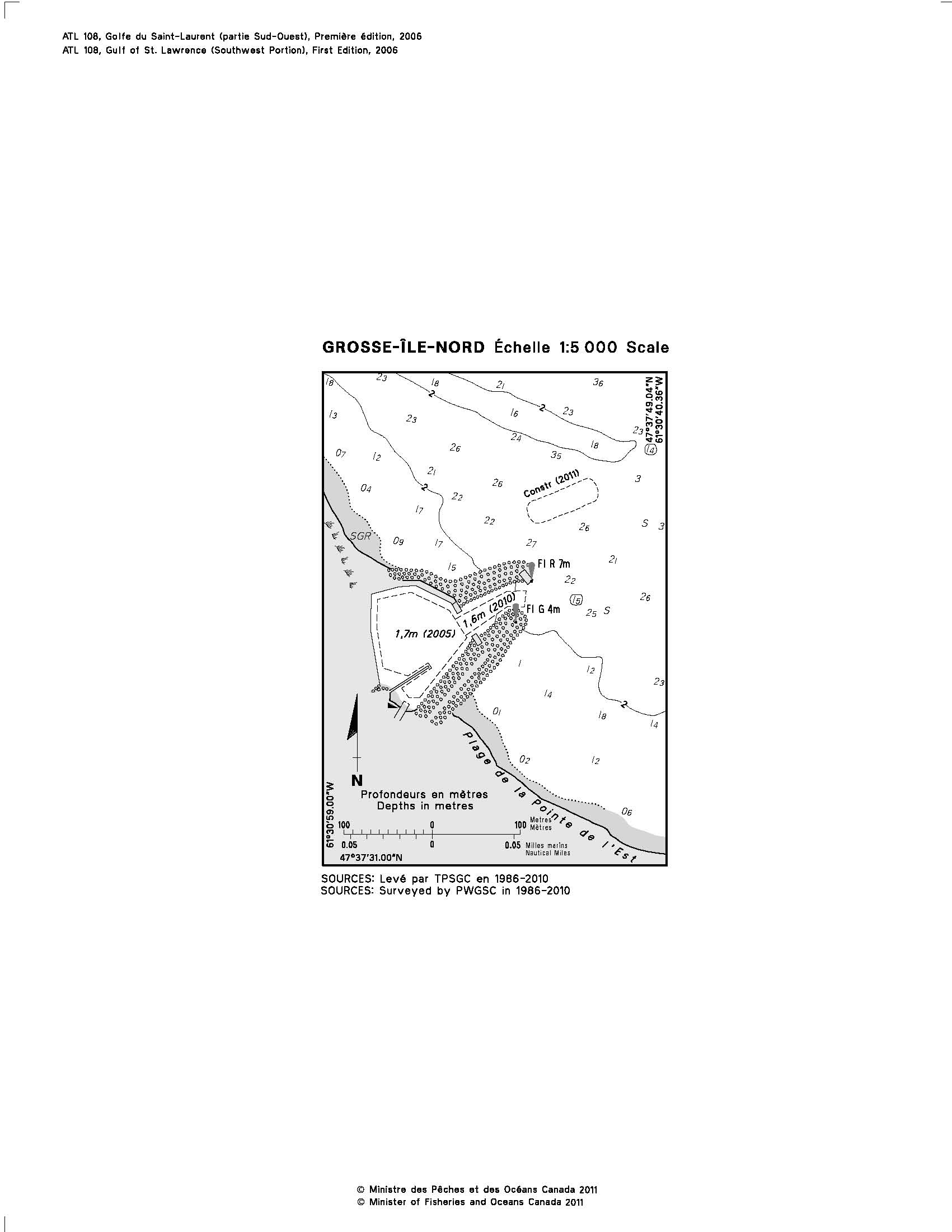
ATL 108 - Gulf of St. Lawrence (Southwest Portion), First Edition, 2006 -
Chapter 2 - Paragraph 112, after "south breakwater."
Insert: A breakwater, not attached to the shore, is 125 m NNE of the entrance of the harbour.
(Q2010-060.2)
Chapter 2 - In the vicinity of paragraph 112
Delete GROSSE-ÎLE-NORD Diagram and replace with the new GROSSE-ÎLE-NORD Diagram provided in Section 4 of this Monthly Edition.
GROSSE-ÎLE-NORD Diagram - PDF format - http://www.notmar.gc.ca/eng/services/notmar/sec4may11-Grosse-ile-nord.pdf or GIF format - http://www.notmar.gc.ca/eng/services/notmar/sec4may11-Grosse-ile-nord.jpg
(Q2010-060.3)
ATL 109 - Gulf of St. Lawrence (Northeast Portion), First Edition, 2006 -
Chapter 3 - Paragraph 9
Delete: ; they are not significant
(N2011-01.9)
Chapter 3 - Paragraph 10, last line
Add: Vessels entering or leaving St. Barbe during the ice season should be aware that wind and tidal streams can combine to cause sudden and dramatic changes in ice pressure at the entrance to the bay. Ships have become beset here. Caution is recommended.
(N2011-02.0)
Chapter 4 - Paragraph 59
Delete: 637-4521
Replace by: 634-6620
(N2011-02.2)
ATL 111 - St. Lawrence River - Île Verte to Québec and Fjord du Saguenay, Third Edition, 2007 -
Chapter 1 - Paragraph 41
Delete: "Another light (1779) ... light structure."
Replace by: Another light (1779.1), only visible north of a line bearing 257°, is shown from the front range light (1779) structure.
(Q2011-009.1)
CEN 300 - General Information, Great Lakes, First Edition, 1996 -
Chapter 1 - Paragraph 88
Delete: 5 m (16 ft)
Replace by: 7 m (23 ft)
(C2011-009.01)
CEN 302 - Lake Ontario, First Edition, 1996 -
Chapter 4 - Paragraph 41
Delete: administered by the Department of Fisheries and Oceans.
Replace by: owned by Canada Lands Company Ltd.
(C2011-008.01)
LIST OF LIGHTS, BUOYS AND FOG SIGNALS CORRECTIONS
NEWFOUNDLAND |
||||||||||
68.52 |
Burin Wharf |
Delete from list. Chart:4616 Edn 05/11(N11-014) |
||||||||
68.53 |
Burin Wharf |
Delete from list. Chart:4616 Edn 05/11(N11-015) |
||||||||
68.55 |
Burin Breakwater |
47 01 53.1 55 10 20.2 |
Fl |
G |
4s |
5.1 |
2 |
Cylindrical mast. |
Year round. Chart:4616 Edn 05/11(N11-016) |
|
130 |
Pass Island Fog Signal |
SW. end of island. 47 28 56.3 56 11 52.8 |
..... |
..... |
..... |
..... |
..... |
Trapezoidal skeleton tower, white rectangular daymark, black horizontal stripe. |
Horn - Blast 3 s; sil. 27 s. Horn points 259°06'. Year round. Chart:4644 Edn 05/11(N11-020) |
|
136 |
New Harbour Island |
47 35 55.7 56 39 41.2 |
Fl |
G |
6s |
27.8 |
5 |
Square skeleton tower, green and white rectangular daymark. 4.7 |
Flash 0.5 s; eclipse 5.5 s. Year round. Chart:4826 Edn 05/11(N11-020) |
|
136.9 |
François Entrance light and bell buoy QL4 |
47 33 47 56 43 23.4 |
Fl |
R |
4s |
..... |
..... |
Red, marked "QL4". |
Year round. Chart:4826 Edn 05/11(N11-020) |
|
137 |
West Point |
François Bay Entrance. 47 33 35.7 56 44 02.1 |
Fl |
G |
5s |
46.0 |
12 |
White square tower, green band on top, attached to building. 4.7 |
Flash 0.1 s; eclipse 4.9 s. Year round. Chart:4826 Edn 05/11(N11-020) |
|
137.23 |
Lower Rock South Cardinal light buoy QLC |
S. of New Harbour. 47 34 50.4 56 38 57.8 |
Q (6) + LFI |
W |
15s |
..... |
..... |
Yellow and black spar, marked "QLC". |
Year round. Chart:4826 Edn 05/11(N11-020) |
|
138 |
Cape La Hune |
On W. side of island. 47 37 44.8 56 51 47 |
Fl |
R |
6s |
25 |
4 |
Square skeleton tower, red and white square daymark. 4.6 |
Flash 1 s; eclipse 5 s. Year round. Chart:4826 Edn 05/11(N11-020) |
|
138.5 |
Watch Rock North Cardinal light and whistle buoy QLB |
E. of Penquin Islands. 47 23 23.9 56 50 06 |
Q |
W |
1s |
..... |
..... |
Black and yellow, marked "QLB". |
Year round. Chart:4826 Edn 05/11(N11-020) |
|
139 H266 |
Harbour Island |
E. side of island. 47 23 00.6 56 58 39.1 |
Fl |
W |
10s |
21.9 |
17 |
Square skeleton tower, red square daymark, white horizontal stripe 5.8 |
Flash 0.2 s; eclipse 9.8 s. Year round. Chart:4826 Edn 05/11(N11-020) |
|
139.1 |
Penguin Island North Cardinal light and whistle buoy QLE |
47 23 41.4 56 56 55.6 |
Q |
W |
1s |
..... |
..... |
Black and yellow, marked "QLE". |
Year round. Chart:4826 Edn 05/11(N11-020) |
|
139.2 |
Penguin Island West Cardinal light and whistle buoy QLW |
E. of island. 47 23 03.3 57 00 53.9 |
Q(9) |
W |
15s |
..... |
..... |
Yellow, black and yellow, marked "QLW". |
Year round. Chart:4826 Edn 05/11(N11-020) |
|
139.3 |
Grey River light and bell buoy QJ |
SW. of Grey River Point. 47 33 51.5 57 06 43.7 |
Mo(A) |
W |
6s |
..... |
..... |
Red and white vertical stripes, marked "QJ". |
Year round. Chart:4826 Edn 05/11(N11-020) |
|
139.5 |
Grey River Point |
W. side of entrance. 47 34 24.9 57 06 47.4 |
Q |
G |
1s |
27.1 |
4 |
Square skeleton tower, green and white rectangular daymark. 4.3 |
Year round. Chart:4826 Edn 05/11(N11-020) |
|
139.51 |
Grey River Wharf |
47 35 20 57 06 05.3 |
Fl |
G |
4s |
..... |
2 |
Mast. 2.6 |
Year round. Chart:4826 Edn 05/11(N11-020) |
|
140.52 |
Ramea South Bank light buoy QR3 |
47 25 53.4 57 19 34.8 |
Fl |
G |
4s |
..... |
..... |
Green, marked "QR3". |
Year round. Chart:4826 Edn 05/11(N11-020) |
|
324.35 |
Beachy Island |
57 08 06.3 61 20 09.5 |
Fl |
W |
4s |
65.9 |
5 |
Square skeleton tower, red rectangular daymark, white horizontal stripe. 4.7 |
Seasonal. Chart:5055 Edn 05/11(N11-020) |
|
324.9 |
Stirrup Island |
E. of Okak Island. 57 34 12.4 61 18 49 |
LFl |
W |
10s |
74.8 |
6 |
Square skeleton tower, red rectangular daymark, white horizontal stripe. 4.7 |
Flash 2 s; eclipse 8 s. Seasonal. Chart:5055 Edn 05/11(N11-020) |
|
338 |
Springdale Wharf |
49 29 58.7 56 03 48.6 |
Fl |
R |
4s |
3.5 |
4 |
Mast. 2.4 |
Seasonal. Chart:4591 Edn 05/11(N11-005) |
|
346.36 |
Ship Run light buoy DSR2 |
W. of Exploits. 49 32 02.3 55 08 35.5 |
Fl |
R |
4s |
..... |
..... |
Red, marked "DSR2". |
Seasonal. Chart:4864 Edn 05/11(N11-020) |
|
347 H656 |
Surgeon Cove Point |
On point, E. side of Ship Run. 49 31 05.3 55 07 05.5 |
Fl |
W |
5s |
73.8 |
16 |
Cylindrical tower, red and white vertical stripe. 4.3 |
Flash 0.1 s; eclipse 4.9 s. Year round. Horn - Blast 3 s; sil. 27 s. Horn points 327°48'. Chart:4864 Edn 05/11(N11-020) |
|
347.2 |
Long Island Outer Shoal light buoy DBE1 |
49 29 07 55 01 13.9 |
Q |
G |
1s |
..... |
..... |
Green spar, marked "DBE1". |
Seasonal. Chart:4864 Edn 05/11(N11-020) |
|
347.3 |
Long Island Rocks light buoy DBE3 |
49 28 52.1 55 01 12.4 |
Fl |
G |
4s |
..... |
..... |
Green spar, marked "DBE3". |
Seasonal. Chart:4864 Edn 05/11(N11-020) |
|
347.4 |
Swan Island Rock light buoy DBE2 |
NE. of Southern Head Cove. 49 27 49.2 55 01 41.7 |
Fl |
R |
4s |
..... |
..... |
Red spar, marked "DBE2". |
Seasonal. Chart:4864 Edn 05/11(N11-020) |
|
348 H658 |
Upper Black Island |
On small island off NW. point. 49 24 47.3 55 08 08.5 |
Fl |
W |
3s |
16.8 |
4 |
Square skeleton tower, red rectangular daymark, white horizontal stripe. 4.3 |
Flash 0.5 s; eclipse 2.5 s. Year round. Chart:4864 Edn 05/11(N11-020) |
|
348.2 |
Upper Black Island Rocks light buoy DBE5 |
W. of island. 49 24 18.4 55 08 16 |
Fl |
G |
4s |
..... |
..... |
Green spar, marked "DBE5". |
Seasonal. Chart:4864 Edn 05/11(N11-020) |
|
361.01 |
Exploits Outer light buoy DE4 |
49 30 58.2 55 04 04.8 |
Fl |
R |
4s |
..... |
..... |
Red spar, marked "DE4". |
Seasonal. Chart:4864 Edn 05/11(N11-020) |
|
361.02 |
Exploits Outer light buoy DE5 |
49 30 55.2 55 04 03 |
Fl |
G |
4s |
..... |
..... |
Green spar, marked "DE5". |
Seasonal. Chart:4864 Edn 05/11(N11-020) |
|
361.03 |
Exploits Inner light buoy DE6 |
49 31 14.3 55 04 03.4 |
Fl |
R |
4s |
..... |
..... |
Red spar, marked "DE6". |
Seasonal. Chart:4864 Edn 05/11(N11-020) |
|
361.04 |
Exploits Inner light buoy DE7 |
49 31 04.8 55 04 06 |
Fl |
G |
4s |
..... |
..... |
Green spar, marked ‘DE7". |
Seasonal. Chart: 4864 Edn 05/11(N11-020) |
|
414 |
Black Island |
Delete from list. Chart:4858 Edn 05/11(N11-018) |
||||||||
414.1 |
Black Island South Cardinal light buoy JWB |
Wesleyville. 49 07 55.2 53 32 36.6 |
Q(6) +LFl |
W |
15s |
..... |
..... |
Yellow and black spar, marked "JWB". |
Year round. Chart:4858 Edn 05/11(N11-017,19) |
|
467.29 |
The Hoof |
Bull Arm. 47 47 52.7 53 51 37.9 |
Fl |
G |
4s |
..... |
..... |
Mast. |
Year round. Chart:4851 Edn 05/11(N11-006-010) |
|
ATLANTIC |
||||||||||
15 H4181.5 |
White Horse Islet |
44 36 09.7 66 48 25.6 |
LFl |
G |
12 s |
13.4 |
4 |
Square skeleton tower, red and white rectangular daymark, green square in centre. 6.6 |
Flash 2 s; eclipse 10 s. Radar reflector. Year round. Chart:4124 Edn 05/11 (F11-128) |
|
16.8 H4184 |
Seal Cove Outer Breakwater |
On outer end of breakwater. 44 38 51.6 66 50 19.5 |
Fl |
G |
6s |
5.0 |
4 |
Cylindrical mast, green, white and black square daymark. 3.7 |
Flash 1 s; eclipse 5 s. Operates at night only. Year round. Chart:4124 Edn 05/11 (F11-106) |
|
58.6 |
Oak Point light buoy S16 |
45 09 51 67 09 38 |
Fl |
R |
4s |
..... |
..... |
Red spar, marked "S16". |
Seasonal. (In place Year round). Chart:4115 Edn 05/11 (F11-110) |
|
58.7 |
Spruce Point light buoy S18 |
45 10 00 67 11 30 |
Fl |
R |
4s |
..... |
..... |
Red spar, marked "S18". |
Seasonal. (In place Year round). Chart:4115 Edn 05/11 (F11-112) |
|
73 H4120.4 |
Morgan Ledge |
SW. of Greens Point. 45 02 14 66 53 36.3 |
Fl |
R |
6s |
5.0 |
7 |
Red square skeleton tower, red and white rectangular daymarks, red triangle in centre. 6.1 |
Flash 1 s; eclipse 5 s. Operates at night only. Year round. Chart:4124 Edn 05/11 (F11-107) |
|
114.5 |
Rowans Point light buoy JE2 |
45 16 15.4 66 05 18.7 |
Fl |
R |
4s |
..... |
..... |
Red, marked "JE2". |
Seasonal. (In place Year round). Chart:4141 Edn 05/11 (F11-114) |
|
116.3 |
Ketepec light buoy JK1 |
45 16 55.8 66 09 17.4 |
Fl |
G |
4s |
..... |
..... |
Green spar, marked "JK1". |
Seasonal. (In place Year round). Chart:4141 Edn 05/11 (F11-116) |
|
116.5 |
Brothers Cove light buoy AM2 |
45 18 22.3 66 06 36.9 |
Fl |
R |
4s |
..... |
..... |
Red, marked "AM2". |
Seasonal. (In place Year round). Chart:4141 Edn 05/11 (F11-117) |
|
118 |
Red Rock light buoy AM3 |
W. of rock. 45 18 30.3 66 06 16.9 |
Fl |
G |
4s |
..... |
..... |
Green spar, marked "AM3". |
Operates at night only. Seasonal. (In place Year round). Chart:4141 Edn 05/11 (F11-118) |
|
118.3 |
Rothesay light buoy AP1 |
45 23 40.3 66 00 17.8 |
Fl |
G |
4s |
..... |
..... |
Green, marked "AP1". |
Seasonal. (In place Year round). Chart:4141 Edn 05/11 (F11-121) |
|
120.5 |
Brandy Point light buoy J25 |
Off point. 45 19 55.3 66 11 12.9 |
Fl |
G |
4s |
..... |
..... |
Green spar, marked "J25". |
Seasonal. (In place Year round). Chart:4141 Edn 05/11 (F11-123) |
|
122.1 |
Purdys Point light buoy J38 |
Off point. 45 22 37.8 66 12 37.9 |
Fl |
R |
4s |
..... |
..... |
Red spar, marked "J38". |
Seasonal. (In place Year round). Chart:4141 Edn 05/11 (F11-126) |
|
122.4 |
Victoria Beach light buoy J41 |
45 25 45.7 66 10 03.9 |
Fl |
G |
4s |
..... |
..... |
Green spar, marked "J41". |
Seasonal. (In place Year round). Chart:4141 Edn 05/11 (F11-127) |
|
123 |
Catons Island light buoy JP |
Off S. side of island. 45 27 55.3 66 06 38.9 |
Fl (2+1) |
G |
6s |
..... |
..... |
Green, red and green spar, marked "JP". |
Seasonal. (In place Year round). Chart:4141 Edn 05/11 (F11-124) |
|
124.5 |
Isle of Pines light buoy J48 |
45 29 05.2 66 05 02.8 |
Fl |
R |
4s |
..... |
..... |
Red spar, marked "J48". |
Seasonal. (In place Year round). Chart:4141 Edn 05/11 (F11-122) |
|
137.7 |
Channel Entrance light buoy EA |
45 52 18.3 66 08 13.9 |
Mo(A) |
W |
6s |
..... |
..... |
Red and white spar, marked "EA". |
Seasonal. (In place Year round). Chart:4142 Edn 05/11 (F11-120) |
|
138 |
Douglas Harbour light buoy EN1 |
W. side of channel entrance. 45 54 30.2 66 05 47.9 |
Fl |
G |
4s |
..... |
..... |
Green, marked "EN1". |
Seasonal. (In place Year round). Chart:4142 Edn 05/11 (F11-119) |
|
139 |
Grand Point Bar South Cardinal light buoy EAB |
At outer end of bar. 45 54 12.2 66 04 04.9 |
Q(6) +LFl |
W |
15s |
..... |
..... |
Yellow and black spar, marked "EAB". |
Seasonal. (In place Year round). Chart:4142 Edn 05/11 (F11-115) |
|
139.75 |
Goat Island light buoy E75 |
46 00 42.2 66 00 31 |
Fl |
G |
4s |
..... |
..... |
Green spar, marked "E75". |
Seasonal. (In place Year round). Chart:4142 Edn 05/11 (F11-113) |
|
141.3 |
Barton Island light buoy E86 |
46 03 56.2 65 56 17.4 |
Fl |
R |
4s |
..... |
..... |
Red, marked "E86". |
Seasonal. (In place Year round). Chart:4142 Edn 05/11 (F11-111) |
|
215 H3887 |
Whale Cove Wharf |
On outer end of wharf. 44 26 08.1 66 10 30.6 |
Fl |
G |
4s |
5.5 |
4 |
Cylindrical mast, green, white and black square daymark. 5.2 |
Operates at night only. Year round. Chart:4118 Edn 05/11 (F11-103) |
|
229 H3876 |
Freeport |
On outer end of public wharf. 44 16 27.8 66 20 08.5 |
F |
R |
..... |
8.7 |
7 |
Pipe swing pole. 6.7 |
Operates at night only. Year round. Chart:4118 Edn 05/11 (F11-105) |
|
253 H3838 |
Sandford Sector |
43 55 07.6 66 09 14.6 |
Iso |
R W G |
2s |
8.3 |
12 |
Square skeleton tower, white rectangular daymark, red horizontal bands. 6.9 |
Red from 090°57' to 134°57'; white from 134°57' to 136°57'; green from 136°57' to 180°57'. White sector indicates preferred channel. Year round. Chart:4243 Edn 05/11 (F11-108) |
|
663.2 H3471 |
Rock Island |
45 16 58.1 61 01 42.6 |
LFl |
R |
6s |
3.7 |
4 |
Triangular skeleton tower, enclosed lower portion. 3.6 |
Flash 2 s; eclipse 4 s. Operates at night only. Seasonal. Chart:4233 Edn 05/11 (G11-057) |
|
666.8 |
Andrew Island East Cardinal light and whistle buoy PK |
45 17 36 60 52 58 |
Q(3) |
W |
10s |
..... |
..... |
Black, yellow and black, marked "PK". |
Year round. Chart:4281 Edn 05/11 (G11-088) |
|
669 |
Grime Shoal light and whistle buoy CV1 |
E. of Grime Rock. 45 21 05.3 60 50 44.6 |
Fl |
G |
4s |
..... |
..... |
Green, marked "CV1". |
Winter spar. Year round. Chart:4281 Edn 05/11 (G11-089) |
|
669.5 |
Bass Rock light and bell buoy PJ2 |
S. of rock. 45 20 38.4 60 52 54.7 |
Fl |
R |
4s |
..... |
..... |
Red, marked "PJ2". |
Winter spar. Year round. Chart:4281 Edn 05/11 (G11-077) |
|
669.8 |
Frying Pan Shoal light and bell buoy PJ3 |
E. of shoal. 45 19 58.2 60 55 41.1 |
Fl |
G |
4s |
..... |
..... |
Green, marked "PJ3". |
Winter spar. Year round. Chart:4281 Edn 05/11 (G11-090) |
|
670 |
Man of War Rock light and bell buoy PK7 |
E. of rock. 45 19 41.3 60 56 56.7 |
Fl |
G |
4s |
..... |
..... |
Green, marked "PK7". |
Winter spar. Year round. Chart:4281 Edn 05/11 (G11-091) |
|
681 |
Bald Rock light and bell buoy PC2 |
N. entrance to Canso Harbour. 45 21 10.8 60 59 36.2 |
Fl |
R |
4s |
..... |
..... |
Red, marked "PC2". |
Winter spar. Year round. Chart:4281 Edn 05/11 (G11-092) |
|
682 |
Canso Harbour light and whistle buoy PC |
N. entrance to harbour. 45 21 43 60 59 41.5 |
Mo(A) |
W |
6s |
..... |
..... |
Red and white vertical stripes, marked "PC". |
Year round. Chart:4281 Edn 05/11 (G11-098) |
|
767 H742 |
Scatarie |
NE. point of Scatarie Island. 46 02 04.3 59 40 33.7 |
Fl |
W |
3s |
19.5 |
15 |
White square tower, red upper portion. 13.9 |
Flash 1 s; eclipse 2 s. Emergency light. Operates at night only. Year round. Horn - Blast 2 s; sil. 3 s; blast 2 s; sil. 3 s; blast 2 s; sil. 48 s. Horn points 105°. Chart:4375 Edn 05/11 (G11-058) |
|
849.4 |
The Point Breakwater |
Outer end of wharf. 46 41 14.9 60 21 33.2 |
Q |
R |
1s |
4.2 |
5 |
Cylindrical mast. 3.5 |
Operates at night only. Seasonal. Chart:4365 Edn 05/11 (G11-111) |
|
1009.1 |
Victoria Harbour light buoy NX2 |
Delete from List. Chart:4405 Edn 05/11 (G11-115) |
||||||||
1009.11 |
Victoria Harbour Fairway light buoy NX |
46 10 35.2 63 28 00.6 |
Mo(A) |
W |
6s |
..... |
..... |
Spar, red and white vertical stripes, marked "NX". |
Seasonal. Chart:4405 Edn 05/11 (G11-114) |
|
1009.12 |
Cameron Point Shoal light buoy NX4 |
46 11 26.2 63 28 31.9 |
Fl |
R |
4s |
..... |
..... |
Red, marked "NX4". |
Seasonal. Chart:4405 Edn 05/11 (G11-116) |
|
1044.1 |
St. Peters Harbour light buoy JD5 |
46 27 00.2 62 44 10.6 |
Fl |
G |
4s |
..... |
Green, marked "JD5". |
Buoy may be repositioned due to shifting channel. Seasonal. Chart:4425 Edn 05/11 (G11-113) |
||
1044.2 |
St. Peters Harbour light buoy JD6 |
46 26 58.2 62 44 24.6 |
Fl |
R |
4s |
..... |
Red, marked "JD6". |
Buoy may be repositioned due to shifting channel. Seasonal. Chart:4425 Edn 05/11 (G11-113) |
||
1044.3 |
St. Peters Harbour light buoy JD8 |
46 26 51.7 62 44 18.6 |
Fl |
R |
4s |
..... |
Red, marked "JD8". |
Buoy may be repositioned due to shifting channel. Seasonal. Chart:4425 Edn 05/11 (G11-113) |
||
1044.4 |
St. Peters Harbour light buoy JD9 |
46 26 48.2 62 44 17.6 |
Fl |
G |
4s |
..... |
Green spar, marked "JD9". |
Buoy may be repositioned due to shifting channel. Seasonal. Chart:4425 Edn 05/11 (G11-113) |
||
1044.5 |
St. Peters Harbour light buoy JD10 |
46 26 45.2 62 44 18.6 |
Fl |
R |
4s |
..... |
Red spar, marked "JD10". |
Buoy may be repositioned due to shifting channel. Seasonal. Chart:4425 Edn 05/11 (G11-113) |
||
1046.04 |
St. Peters Harbour light buoy JD9.5 |
46 26 42.2 62 44 14.6 |
Fl |
G |
4s |
..... |
..... |
Green, marked "JD9.5". |
Buoy may be repositioned due to shifting channel. Seasonal. Chart:4425 Edn 05/11 (G11-119) |
|
1046.05 |
St. Peters Harbour light buoy JD11 |
At harbour entrance. 46 26 39.2 62 44 12.1 |
Q |
G |
1s |
..... |
..... |
Green, marked "JD11". |
Buoy may be repositioned due to shifting channel. Seasonal. Chart:4425 Edn 05/11 (G11-119) |
|
1046.06 |
St. Peters Harbour light buoy JD12 |
46 26 24.6 62 44 07.8 |
Fl |
R |
4s |
..... |
..... |
Red, marked "JD12". |
Buoy may be repositioned due to shifting channel. Seasonal. Chart:4425 Edn 05/11 (G11-113) |
|
1046.1 |
St. Peters Bay light buoy JD13 |
46 26 35.2 62 43 52.6 |
Q |
G |
1s |
..... |
..... |
Green, marked "JD13". |
Buoy may be repositioned due to shifting channel. Seasonal. Chart:4425 Edn 05/11 (G11-119) |
|
1046.15 |
St. Peters Harbour light buoy JD16 |
46 26 31.2 62 43 29.6 |
Q |
R |
1s |
..... |
..... |
Red, marked "JD16". |
Buoy may be repositioned due to shifting channel. Seasonal. Chart:4425 Edn 05/11 (G11-119) |
|
1046.2 |
St. Peters Bay light buoy JD18 |
46 26 26.7 62 43 17.6 |
Q |
R |
1s |
..... |
..... |
Red, marked "JD18". |
Buoy may be repositioned due to shifting channel. Seasonal. Chart:4425 Edn 05/11 (G11-119) |
|
1046.3 |
St. Peters Bay light buoy JD21 |
46 26 07.2 62 42 50.6 |
Fl |
G |
4s |
..... |
..... |
Green, marked "JD21". |
Buoy may be repositioned due to shifting channel. Seasonal. Chart:4425 Edn 05/11 (G11-119) |
|
1047.01 |
Savage Harbour light buoy JE6 |
46 26 10.2 62 49 53.6 |
Fl |
R |
4s |
..... |
..... |
Red spar, marked "JE6". |
Buoy may be repositioned due to shifting channel. Seasonal. Chart:4425 Edn 05/11 (G11-113) |
|
1047.02 |
Savage Harbour light buoy JE8 |
46 25 58.4 62 49 58.9 |
Fl |
R |
4s |
..... |
..... |
Red, marked "JE8". |
Buoy may be repositioned due to shifting channel. Seasonal. Chart:4425 Edn 05/11 (G11-113) |
|
1047.021 |
Savage Harbour light buoy JE8/2 |
46 25 47.4 62 50 01.4 |
Q |
R |
1s |
..... |
..... |
Red, marked "JE8/2". |
Buoy may be repositioned due to shifting channel. Seasonal. Chart:4425 Edn 05/11 (G11-113) |
|
1047.028 |
Savage Harbour light buoy JE9 |
46 25 44.5 62 50 05 |
Fl |
G |
4s |
...... |
...... |
Green, marked "JE9". |
Buoy may be repositioned due to shifting channel. Seasonal. Chart:4425 Edn 05/11 (G11-113) |
|
1047.03 |
Savage Harbour Entrance light buoy JE10 |
46 25 46.1 62 50 03.3 |
Q |
R |
1s |
..... |
..... |
Red, marked "JE10". |
Buoy may be repositioned due to shifting channel. Seasonal. Chart:4425 Edn 05/11 (G11-113) |
|
1047.04 |
Savage Harbour light buoy JE12 |
46 25 49.7 62 50 12.5 |
Fl |
R |
4s |
..... |
..... |
Red spar, marked "JE12". |
Buoy may be repositioned due to shifting channel. Seasonal. Chart:4425 Edn 05/11 (G11-113) |
|
1047.051 |
Savage Harbour light buoy JE14 |
46 25 50 62 50 04.4 |
Fl |
R |
4s |
..... |
..... |
Red, marked "JE14". |
Buoy may be repositioned due to shifting channel. Seasonal. Chart:4425 Edn 05/11 (G11-113) |
|
1047.06 |
Savage Harbour light buoy JE17 |
46 25 45.2 62 50 13.4 |
Fl |
G |
4s |
..... |
..... |
Green spar, marked "JE17". |
Buoy may be repositioned due to shifting channel. Seasonal. Chart:4425 Edn 05/11 (G11-113) |
|
1047.1 |
Savage Harbour light buoy JE15 |
46 25 49.2 62 50 08.6 |
Q |
G |
1s |
..... |
..... |
Green, marked "JE15". |
Buoy may be repositioned due to shifting channel. Seasonal. Chart:4425 Edn 05/11 (G11-113) |
|
1047.2 |
Savage Harbour light buoy JE16 |
46 25 39.2 62 50 15.6 |
Q |
R |
1s |
..... |
..... |
Red, marked "JE16". |
Buoy may be repositioned due to shifting channel. Seasonal. Chart:4425 Edn 05/11 (G11-113) |
|
1049.1 |
Grand Tracadie light buoy JH6 |
46 25 16.2 63 02 26.6 |
Fl |
R |
4s |
..... |
..... |
Red spar, marked "JH6". |
Buoy may be repositioned due to shifting channel. Seasonal. Chart:4425 Edn 05/11 (G11-113) |
|
1049.12 |
Grand Tracadie light buoy JH7/5 |
46 24 54 63 02 23.4 |
Fl |
G |
4s |
..... |
..... |
Green spar, marked "JH7/5". |
Buoy may be repositioned due to shifting channel. Seasonal. Chart:4425 Edn 05/11 (G11-113) |
|
1049.13 |
Grand Tracadie light buoy JH7/7 |
46 24 59.4 63 02 24 |
Fl |
G |
4s |
..... |
..... |
Green, marked "JH7/7". |
Buoy may be repositioned due to shifting channel. Seasonal. Chart:4425 Edn 05/11 (G11-113) |
|
1049.2 |
Grand Tracadie Outer light buoy JH9 |
46 24 49.2 63 02 25.8 |
Fl |
G |
4s |
..... |
..... |
Green, marked "JH9". |
Buoy may be repositioned due to shifting channel. Seasonal. Chart:4425 Edn 05/11 (G11-113) |
|
1049.21 |
Grand Tracadie light buoy JH10 |
46 24 56.4 63 02 25.8 |
Fl |
R |
4s |
..... |
..... |
Red spar, marked "JH10". |
Buoy may be repositioned due to shifting channel. Seasonal. Chart:4425 Edn 05/11 (G11-113) |
|
1049.4 |
Grand Tracadie Harbour Entrance light buoy JH16 |
46 24 36.2 63 02 14.6 |
Fl |
R |
4s |
..... |
..... |
Red, marked "JH16". |
Buoy may be repositioned due to shifting channel. Seasonal. Chart:4425 Edn 05/11 (G11-113) |
|
1049.5 |
Grand Tracadie Harbour East light buoy JH18 |
46 24 38.2 63 01 49.6 |
Q |
R |
1s |
..... |
..... |
Red, marked "JH18". |
Buoy may be repositioned due to shifting channel. Seasonal. Chart:4425 Edn 05/11 (G11-113) |
|
1049.6 |
Grand Tracadie Harbour South light buoy JH21 |
46 24 22.7 63 01 39.6 |
Fl |
G |
4s |
..... |
..... |
Green, marked "JH21". |
Buoy may be repositioned due to shifting channel. Seasonal. Chart:4425 Edn 05/11 (G11-113) |
|
1050.1 |
Covehead Harbour light buoy JJ3 |
46 26 07.9 63 08 36.7 |
Q |
G |
1s |
..... |
..... |
Green, marked "JJ3". |
Buoy may be repositioned due to shifting channel. Seasonal. Chart:4425 Edn 05/11 (G11-113) |
|
1050.12 |
Covehead Harbour light buoy JJ4 |
46 26 08.5 63 08 39.2 |
Fl |
R |
4s |
..... |
..... |
Red, marked "JJ4". |
Buoy may be repositioned due to shifting channel. Seasonal. Chart:4425 Edn 05/11 (G11-113) |
|
1050.13 |
Covehead Harbour light buoy JJ5 |
46 26 02.9 63 08 39 |
Fl |
G |
4s |
..... |
..... |
Green, marked "JJ5". |
Buoy may be repositioned due to shifting channel. Seasonal. Chart:4425 Edn 05/11 (G11-113) |
|
1050.3 |
Covehead Harbour light buoy JJ7 |
46 25 55.3 63 08 44.3 |
Q |
G |
1s |
..... |
..... |
Green, marked "JJ7". |
Buoy may be repositioned due to shifting channel. Seasonal. Chart:4425 Edn 05/11 (G11-113) |
|
1050.5 |
Covehead Harbour light buoy JJ8 |
46 25 55.7 63 08 45.4 |
Fl |
R |
4s |
..... |
..... |
Red, marked "JJ8". |
Buoy may be repositioned due to shifting channel. Seasonal. Chart:4425 Edn 05/11 (G11-113) |
|
1050.9 |
Covehead Harbour light buoy JJ9 |
46 25 51 63 08 45.8 |
Fl |
G |
4s |
..... |
..... |
Green, marked "JJ9". |
Buoy may be repositioned due to shifting channel. Seasonal. Chart:4425 Edn 05/11 (G11-113) |
|
1054.1 |
North Rustico light buoy JK3 |
46 27 24.8 63 17 06.4 |
Fl |
G |
4s |
..... |
..... |
Green spar, marked "JK3". |
Buoy may be repositioned due to shifting channel. Seasonal. Chart:4467 Edn 05/11 (G11-113) |
|
1054.11 |
North Rustico light buoy JK4 |
46 27 24.2 63 17 12.6 |
Fl |
R |
4s |
..... |
..... |
Red spar, marked "JK4". |
Buoy may be repositioned due to shifting channel. Seasonal. Chart:4467 Edn 05/11 (G11-113) |
|
1054.3 |
Rustico Harbour light buoy JK7 |
46 27 25 63 17 18 |
Fl |
G |
4s |
..... |
..... |
Green, marked "JK7". |
Buoy may be repositioned due to shifting channel. Seasonal. Chart:N/A Edn 05/11 (G11-113) |
|
1054.4 |
Rustico light buoy JK9 |
46 27 24.2 63 17 11.8 |
Fl |
G |
4s |
..... |
..... |
Green, marked "JK9". |
Buoy may be repositioned due to shifting channel. Seasonal. Chart:4467 Edn 05/11 (G11-113) |
|
1054.6 |
Rustico light buoy JK12 |
46 27 17.2 63 17 26.1 |
Q |
R |
1s |
..... |
..... |
Red, marked "JK12". |
Buoy may be repositioned due to shifting channel. Seasonal. Chart:4467 Edn 05/11 (G11-113) |
|
1054.9 |
Rustico Harbour light buoy JK13 |
46 27 20.2 63 17 54.8 |
Fl |
G |
4s |
..... |
..... |
Green, marked "JK13". |
Buoy may be repositioned due to shifting channel. Seasonal. Chart:4467 Edn 05/11 (G11-113) |
|
1060.45 |
New London Harbour light buoy JM6 |
46 30 59.7 63 28 55.8 |
Fl |
R |
4s |
..... |
..... |
Red, marked "JM6". |
Buoy may be repositioned due to shifting channel. Seasonal. Chart:4467 Edn 05/11 (G11-113) |
|
1060.55 |
Southwest River light buoy JN1 |
46 30 36.7 63 28 58.6 |
Fl |
G |
4s |
..... |
..... |
Green, marked "JN1". |
Buoy may be repositioned due to shifting channel. Seasonal. Chart:4467 Edn 05/11 (G11-113) |
|
1060.57 |
New London light buoy JN3 |
46 30 31.7 63 28 41.4 |
Fl |
G |
4s |
..... |
..... |
Green spar, marked "JN3". |
Buoy may be repositioned due to shifting channel. Seasonal. Chart:4467 Edn 05/11 (G11-113) |
|
1060.6 |
Southwest River light buoy JN4 |
46 30 20.2 63 28 16.3 |
Q |
R |
1s |
..... |
..... |
Red spar, marked "JN4". |
Buoy may be repositioned due to shifting channel. Seasonal. Chart:4467 Edn 05/11 (G11-119) |
|
1069.65 |
Darnley Basin light buoy JU5 |
46 33 28.2 63 40 57.7 |
Q |
G |
1s |
..... |
..... |
Green, marked "JU5". |
Buoy may be repositioned due to shifting channel. Seasonal. Chart:4491 Edn 05/11 (G11-113) |
|
1069.7 |
Darnley Basin light buoy JU7 |
46 33 20.2 63 41 16.7 |
Fl |
G |
4s |
..... |
..... |
Green, marked "JU7". |
Buoy may be repositioned due to shifting channel. Seasonal. Chart:4491 Edn 05/11 (G11-113) |
|
1069.8 |
Darnley Basin light buoy JU8 |
46 33 19.2 63 41 42.7 |
Q |
R |
1s |
..... |
..... |
Red, marked "JU8". |
Buoy may be repositioned due to shifting channel. Seasonal. Chart:4491 Edn 05/11 (G11-113) |
|
1069.9 |
Darnley Basin light buoy JU9 |
46 33 21.2 63 41 57.7 |
Q |
G |
1s |
..... |
..... |
Green, marked "JU9". |
Buoy may be repositioned due to shifting channel. Seasonal. Chart:4491 Edn 05/11 (G11-113) |
|
1071.39 |
Conway Inlet light buoy JS2 |
46 39 10.2 63 51 19.7 |
Fl |
R |
4s |
..... |
..... |
Red spar, marked "JS2". |
Buoy may be repositioned due to shifting channel. Seasonal. Chart:4491 Edn 05/11 (G11-113) |
|
1071.41 |
Conway Inlet light buoy JS3 |
46 39 09.3 63 51 18.7 |
Q |
G |
1s |
..... |
..... |
Green spar, marked "JS3". |
Buoy may be repositioned due to shifting channel. Seasonal. Chart:4491 Edn 05/11 (G11-113) |
|
1071.42 |
Conway Inlet light buoy JS4 |
46 39 09.5 63 51 34.7 |
Fl |
R |
4s |
..... |
..... |
Red spar, marked "JS4". |
Buoy may be repositioned due to shifting channel. Seasonal. Chart:4491 Edn 05/11 (G11-113) |
|
1071.45 |
Conway Inlet light buoy JS5 |
46 39 08.2 63 51 34.5 |
Fl |
G |
4s |
..... |
..... |
Green spar, marked "JS5". |
Buoy may be repositioned due to shifting channel. Seasonal. Chart:4491 Edn 05/11 (G11-113) |
|
1071.5 |
Conway Inlet light buoy JS7 |
46 39 05.9 63 51 48.2 |
Fl |
G |
4s |
..... |
..... |
Green spar, marked "JS7". |
Buoy may be repositioned due to shifting channel. Seasonal. Chart:4491 Edn 05/11 (G11-113) |
|
1071.52 |
Conway Inlet light buoy JS8 |
46 39 06.5 63 51 56.8 |
Fl |
R |
4s |
..... |
..... |
Red spar, marked "JS8". |
Buoy may be repositioned due to shifting channel. Seasonal. Chart:4491 Edn 05/11 (G11-113) |
|
1071.89 |
Conway Inlet light buoy JS12 |
46 39 05.2 63 52 07.8 |
Fl |
R |
4s |
..... |
..... |
Red spar, marked "JS12". |
Buoy may be repositioned due to shifting channel. Seasonal. Chart:4491 Edn 05/11 (G11-113) |
|
1071.9 |
Conway Inlet light buoy JS13 |
46 39 03.9 63 52 16 |
Fl |
G |
4s |
..... |
..... |
Green spar, marked "JS13". |
Buoy may be repositioned due to shifting channel. Seasonal. Chart:4491 Edn 05/11 (G11-113) |
|
1071.95 |
Conway Inlet light buoy JS14 |
46 39 05.3 63 52 16.8 |
Q |
R |
1s |
..... |
..... |
Red spar, marked "JS14". |
Buoy may be repositioned due to shifting channel. Seasonal. Chart:4491 Edn 05/11 (G11-113) |
|
1071.96 |
Conway Inlet light buoy JS21 |
46 39 28.3 63 52 34.4 |
Q |
G |
1s |
..... |
..... |
Green, marked "JS21". |
Buoy may be repositioned due to shifting channel. Seasonal. Chart:4491 Edn 05/11 (G11-113) |
|
1071.961 |
Conway Inlet light buoy JS22 |
46 39 29.6 63 52 49.7 |
Q |
R |
1s |
..... |
..... |
Red, marked "JS22". |
Buoy may be repositioned due to shifting channel. Seasonal. Chart:4491 Edn 05/11 (G11-113) |
|
1071.962 |
Conway Inlet light buoy JS23 |
46 39 36.2 63 52 57.3 |
Q |
G |
1s |
..... |
..... |
Green, marked "JS23". |
Buoy may be repositioned due to shifting channel. Seasonal. Chart:4491 Edn 05/11 (G11-113) |
|
1071.963 |
Conway Inlet light buoy JS24 |
46 39 37.3 63 52 55.6 |
Fl |
R |
4s |
..... |
..... |
Red, marked "JS24". |
Buoy may be repositioned due to shifting channel. Seasonal. Chart:4491 Edn 05/11 (G11-113) |
|
1071.977 |
Conway Inlet light buoy JS27 |
46 39 43.8 63 53 05.7 |
Q |
G |
1s |
..... |
..... |
Green, marked "JS27". |
Buoy may be repositioned due to shifting channel. Seasonal. Chart:4491 Edn 05/11 (G11-113) |
|
1071.98 |
Conway Inlet light buoy JS32 |
46 39 37.7 63 53 29.3 |
Q |
R |
1s |
..... |
..... |
Red, marked "JS32". |
Buoy may be repositioned due to shifting channel. Seasonal. Chart:4491 Edn 05/11 (G11-113) |
|
1071.99 |
Conway Inlet light buoy JS33 |
46 39 36.7 63 53 44.5 |
Q |
G |
1s |
..... |
..... |
Green, marked "JS33". |
Buoy may be repositioned due to shifting channel. Seasonal. Chart:4491 Edn 05/11 (G11-113) |
|
1072.1 |
Conway Inlet light buoy JS39 |
46 39 24.5 63 53 46.3 |
Q |
G |
1s |
..... |
..... |
Green, marked "JS39". |
Buoy may be repositioned due to shifting channel. Seasonal. Chart:4491 Edn 05/11 (G11-113) |
|
1072.4 |
Conway Inlet light buoy JS42 |
46 39 22.4 63 53 59 |
Fl |
R |
4s |
..... |
..... |
Red, marked "JS42". |
Buoy may be repositioned due to shifting channel. Seasonal. Chart:4491 Edn 05/11 (G11-113) |
|
1072.5 |
Conway Inlet light buoy JS43 |
46 39 20.9 63 54 26.6 |
Q |
G |
1s |
..... |
..... |
Green, marked "JS43". |
Buoy may be repositioned due to shifting channel. Seasonal. Chart:4491 Edn 05/11 (G11-113) |
|
1072.6 |
Conway Inlet light buoy JS44 |
46 39 21.5 63 54 26.6 |
Fl |
R |
4s |
..... |
..... |
Red, marked "JS44". |
Buoy may be repositioned due to shifting channel. Seasonal. Chart:4491 Edn 05/11 (G11-113) |
|
1075.2 |
Cascumpeque light buoy JV4 |
46 48 12.4 64 00 47 |
Fl |
R |
4s |
..... |
..... |
Red spar, marked "JV4". |
Buoy may be repositioned due to shifting channel. Seasonal. Chart:4492 Edn 05/11 (G11-113) |
|
1075.3 |
Cascumpeque light buoy JV5 |
46 48 07.6 64 00 51.6 |
Fl |
G |
4s |
..... |
..... |
Green, marked "JV5". |
Buoy may be repositioned due to shifting channel. Seasonal. Chart:4492 Edn 05/11 (G11-113) |
|
1075.32 |
Cascumpeque light buoy JV8 |
46 48 15.7 64 01 20.7 |
Fl |
R |
4s |
..... |
..... |
Red spar, marked "JV8". |
Buoy may be repositioned due to shifting channel. Seasonal. Chart:4492 Edn 05/11 (G11-113) |
|
1075.33 |
Cascumpeque light buoy JV6 |
46 48 13.2 64 01 05.7 |
Q |
R |
1s |
..... |
..... |
Red spar, marked "JV6". |
Buoy may be repositioned due to shifting channel. Seasonal. Chart:4492 Edn 05/11 (G11-113) |
|
1075.34 |
Cascumpeque light buoy JV7 |
46 48 07.8 64 01 08.2 |
Q |
G |
1s |
..... |
..... |
Green spar, marked "JV7". |
Buoy may be repositioned due to shifting channel. Seasonal. Chart:4492 Edn 05/11 (G11-113) |
|
1075.4 |
Cascumpeque light buoy JV9 |
46 48 08.5 64 01 37.6 |
Fl |
G |
4s |
..... |
..... |
Green spar, marked "JV9". |
Buoy may be repositioned due to shifting channel. Seasonal. Chart:4492 Edn 05/11 (G11-113) |
|
1075.5 |
Alberton Harbour light buoy JV10 |
46 48 12.9 64 01 55.4 |
Q |
R |
1s |
..... |
..... |
Red spar, marked "JV10". |
Buoy may be repositioned due to shifting channel. Seasonal. Chart:4492 Edn 05/11 (G11-113) |
|
1075.6 |
Alberton Harbour light buoy JV15 |
46 48 00.6 64 02 31.8 |
Fl |
G |
4s |
..... |
..... |
Green spar, marked "JV15". |
Buoy may be repositioned due to shifting channel. Seasonal. Chart:4492 Edn 05/11 (G11-113) |
|
1075.7 |
Alberton Harbour light buoy JV12 |
46 47 47.2 64 03 17.8 |
Q |
R |
1s |
..... |
..... |
Red, marked "JV12". |
Buoy may be repositioned due to shifting channel. Seasonal. Chart:4492 Edn 05/11 (G11-113) |
|
1084.52 |
Tignish Inner light buoy JX5 |
46 57 09.3 63 59 55.1 |
Fl |
G |
4s |
..... |
..... |
Green, marked "JX5". |
Buoy may be repositioned due to shifting channel. Seasonal. Chart:4023 Edn 05/11 (G11-113) |
|
1084.53 |
Tignish Inner light buoy JX7 |
46 57 12.6 63 59 58.3 |
Fl |
G |
4s |
..... |
..... |
Green, marked "JX7". |
Buoy may be repositioned due to shifting channel. Seasonal. Chart:4023 Edn 05/11 (G11-113) |
|
1084.54 |
Tignish Inner light buoy JX9 |
46 57 12 64 00 09.2 |
Fl |
G |
4s |
..... |
..... |
Green, marked "JX9". |
Buoy may be repositioned due to shifting channel. Seasonal. Chart:4023 Edn 05/11 (G11-113) |
|
1268 1269 |
Miscou Harbour range |
| | | | | | | |
|
|||||||
1608 H1958 |
Îles aux Perroquets |
Minganie on NW. island. 50 13 14.1 64 12 24.1 |
Fl |
W |
5s |
24.0 |
12 |
White octagonal tower, red upper portion. 12.3 |
Flash 1 s; eclipse 4 s. Obscured by île Mingan between 269° and 292°. Operates at night only. Seasonal. Chart:4432 Edn 05/11 (Q11-043) |
|
1656 |
ODAS light buoy IML-7 |
Off La Martre. 49 14 30 66 12 00 |
Fl(5) |
Y |
20s |
..... |
..... |
Yellow, marked "IML-7". |
Seasonal. Chart:4026 Edn 05/11 (Q11-049) |
|
2013 H2354 |
Pointe Langlois |
On S. shore E. of point. 46 35 02 71 59 25 |
Iso |
G |
2s |
21.8 |
6 |
Skeleton tower, 3 orange rectangular daymarks on E., N. and W. faces. 11.1 |
Radar reflector. Year round. Chart:1314 Edn 05/11 (Q11-054) |
|
2109 |
Pointe des Ormes light buoy C71 |
Champlain, main channel. 46 17 14.2 72 35 22 |
Fl |
G |
4s |
..... |
..... |
Green, marked "C71". |
Seasonal. Chart:1313 Edn 05/11 (Q11-044) |
|
2173 |
Île des Barques light buoy S123 |
46 04 57 73 00 37.5 |
Fl |
G |
4s |
..... |
..... |
Green, marked "S123". |
Winter spar. Year round. Chart:1312 Edn 05/11 (Q11-052) |
|
INLAND WATERS |
||||||||||
500.8 |
Newcastle Entrance |
43 53 43.4 78 34 33.4 |
F |
G |
..... |
6.2 |
..... |
White cylindrical tower, green upper portion. |
Privately maintained by Newcastle Marina. Seasonal. Chart:2058 Edn 05/11(B11-006) |
|
513.1 |
Toronto Harbour Bifurcation light buoy TAB |
43 37 34.6 79 24 45.4 |
Fl (2+1) |
G |
6s |
..... |
..... |
Green, red and green, marked "TAB". |
Maintained by the Toronto Port Authority. Seasonal. (In place Year round.) Chart:2085 Edn 05/11(B11-004) |
|
513.2 |
Toronto Harbour Bifurcation light buoy TCB |
43 37 46.9 79 24 18.7 |
Fl (2+1) |
G |
6s |
..... |
..... |
Green, red and green, marked "TCB. |
Maintained by the Toronto Port Authority. Seasonal. (In place Year round.) Chart:2085 Edn 05/11(B11-005) |
|

