
Archived information
The Standard on Web Usability replaces this content. This content is archived because Common Look and Feel 2.0 Standards have been rescinded.
Archived information is provided for reference, research or recordkeeping purposes. It is not subject to the Government of Canada Web Standards and has not been altered or updated since it was archived.
|
|
Fisheries and Oceans Canada |
Pêches et Ocèans Canada |
|
 |
|||
| MONTHLY EDITION N° 4 April 25th, 2014 |
|||
|
CONTENTS |
|||
Page |
|||
| Section 1 |
Safety and General Information | 1 - 12 |
|
| Section 2 |
Chart Corrections | 13 - 21 |
|
| Section 3 |
Radio Aids to Marine Navigation Corrections | 22 - 25 |
|
| Section 4 |
Sailing Directions and Small Craft Guide Corrections | 26 - 30 |
|
| Section 5 |
List of Lights, Buoys and Fog signals Corrections | 31 - 33 |
|
Maritime Services Directorate Aids to Navigation |
|||
Fisheries and Oceans Canada - Official publication of the Canadian Coast Guard |
|||

Geographical positions refer directly to the graduations of the largest scale Canadian Hydrographic chart unless otherwise indicated.
Bearings refer to the true compass and are measured clockwise from 000° (North) clockwise to 359°; those relating to lights are from seaward.
Visibility of lights is that in clear weather.
Depths - The units used for soundings (metres, fathoms or feet) are stated in the title of each chart.
Elevations are normally given above Higher High Water, Large Tides unless otherwise indicated.
Distances may be calculated as follows:
1 nautical mile = 1 852 metres (6,076.1 feet)
1 statute mile = 1 609.3 metres (5,280 feet)
1 metre = 3.28 feet
Temporary & Preliminary Notices are indicated by a (T) or a (P) before the chart action and in the section 1. Please note that Nautical charts are not amended by the Canadian Hydrographic Service for Temporary (T) and Preliminary (P) Notices. It is recommended that mariners chart these corrections in pencil. Listing of charts affected by Temporary and Preliminary Notices are revised and promulgated quarterly in Section 1 of the Monthly Edition.
Please note that, in addition to the temporary and preliminary changes normally advertised as (T) and (P) Notices, there are a few permanent changes to navigational aids that have been advertised as Preliminary Notices to Mariners while charts are being updated for new editions.
Marine Information Report & Suggestion Sheet - Mariners are requested to notify the responsible authorities when new or suspected dangers to navigation are discovered, changes observed in aids to navigation or corrections to publications are seen to be necessary. Such communications can be made using the Marine Information Report & Suggestion Sheet inserted on the last page of each monthly edition of Notices to Mariners.
Canadian Hydrographic Service - Information Published in Section 2 Notices to Mariners - Mariners are advised that only the most critical changes that directly affect safety to navigation are issued in Chart Corrections - Section 2. This limitation is required to ensure that charts remain as clear and easy to read as possible. As a result, mariners may see minor discrepancies of a non-critical nature between information in official publications. For example, a small change in the nominal range or height of a light may not result in the production of a chart correction, in Notices to Mariners, but may result in a List of Light, Buoys and Fog Signals correction.
In case of discrepancy between information provided on CHS charts related to aids to navigation, and the List of Light publication, the latter shall be deemed as containing the most up to date information
Canadian Nautical Charts & Publications - A source list of Canadian Nautical Charts & Publications is published in Notice No. 14 of the Notices to Mariners Annual Edition April 2011. The source supply and the prices effective at the time of printing are listed. For current chart edition dates refer to the following web site: http://www.chs-shc.gc.ca/charts-cartes/paper-papier/index-eng.asp
NOTE: Cette publication est aussi disponible en français.
Corrections to nautical charts will be listed in numeric order by chart number. Each chart correction listed applies only to that particular chart. Related charts, if any, will have their own specific correction listed separately.
Users should also refer to CHS Chart 1 Symbols, Abbreviations Terms for additional information pertaining to the correction of charts.
The illustration below describes the elements that will comprise a typical Section 2 chart correction.

MONTHLY EDITION OF NOTICES TO MARINERS
WEB ACCESS
We are offering a feature where subscribers to our on-line service are able to receive the complete electronic monthly edition of
our Notices to Mariners. We are encouraging our clients to visit the web site to subscribe for this service:
http://www.notmar.gc.ca/subscribe/
Users wishing to receive information updates for their charts can do so by setting up a ’User Profile’ on the following web page http://www.notmar.gc.ca/search/mycharts-eng.php?czoxOToibnRtPXN0ZXBfb25lJmxhbmc9ZSI7
This feature permits users to register the nautical charts they currently have in their possession. Registrants are then automatically notified by e-mail when a Notice to Mariners is published concerning these charts.
ADVISORY
NOTICES TO SHIPPING (WRITTEN AND BROADCAST)
The Canadian Coast Guard is implementing a number of changes to the aids to navigation system in Canada.
These changes are advertised as Notices to Shipping (Broadcast and Written) by the Canadian Coast Guard and are followed up with Notices to Mariners, then charts are updated by hand correction, reprints or new editions.
Mariners are advised that all relevant Written Notices to Shipping should be kept until superseded by Notices to Mariners or through revised charts issued by the Canadian Hydrographic Service.
Written Notices to Shipping are available on the Canadian Coast Guard Website at: www.ccg-gcc.gc.ca/eng/CCG/NOTSHIP.
The Canadian Hydrographic Service is reviewing the impact of these changes with the Canadian Coast Guard and together we are preparing an action plan on the issuing of chart revisions.
For further information contact your local Regional Notices to Shipping (NOTSHIP) issuing authorities.
|
Newfoundland |
Maritimes |
|
Quèbec |
Central & Arctic *Fisheries and Oceans Canada |
* Services provided in English and French
INDEX
| CANADIAN HYDROGRAPHIC SERVICE - ANNOUNCEMENT REGARDING CANADIAN HYDROGRAPHIC SERVICE CHART PATCHES | 1 |
| CANADIAN HYDROGRAPHIC SERVICE - CUMULATIVE CHART CORRECTIONS | 1 |
| CANADIAN HYDROGRAPHIC SERVICE - CURRENT CHART EDITION DATES | 1 |
| CANADIAN HYDROGRAPHIC SERVICE - PRINT ON DEMAND CHARTS - CARE AND USE | 1 |
| CANADIAN HYDROGRAPHIC SERVICE - TRANSPORT CANADA NAVIGATION SAFETY – ECDIS | 2 |
| CONSOLIDATION OF MARINE COMMUNICATIONS AND TRAFFIC SERVICES (MCTS) CENTRES | 2 |
| CANADIAN COAST GUARD PUBLICATION - RADIO AIDS TO MARINE NAVIGATION (ATLANTIC, ST. LAWRENCE, GREAT LAKES, LAKE WINNIPEG AND EASTERN ARCTIC) PUBLICATION – 2013 - THE COMMERCIAL PUBLIC CORRESPONDENCE SERVICE | 2 |
| *401 SAGUENAY-ST. LAWRENCE MARINE PARK AND SURROUNDING WATERS - WHALE PROTECTION | 3 |
| *402 CANADIAN HYDROGRAPHIC SERVICE - NAUTICAL CHARTS. | 4 |
| *403 CANADIAN HYDROGRAPHIC SERVICE - ELECTRONIC NAVIGATIONAL CHARTS. | 5 |
| *404 CANADIAN HYDROGRAPHIC SERVICE - RASTER DIGITAL CHARTS (BSB V4). | 5 |
| *405 TRANSPORT CANADA - ACCEPTANCE OF NAUTICAL PUBLICATIONS IN ELECTRONIC FORM IN CANADA. | 5 |
| *406 TRANSPORT CANADA – SHIP SAFETY BULLETIN. | 6 |
| *407 CANADIAN COAST GUARD PUBLICATION - NEW EDITION OF THE ANNUAL EDITION OF NOTICES TO MARINERS – 2014. | 6 |
| *408 CANADIAN COAST GUARD - LIST OF CHARTS AND REFERENCE CHARTS (SECTION I) AFFECTED BY TEMPORARY AND PRELIMINARY NOTICES. | 7 |
| *409 CANADIAN HYDROGRAPHIC SERVICE – SAILING DIRECTIONS – ARC 402 — EASTERN ARCTIC, FIRST EDITION, 2014 IS NOW AVAILABLE AS A PRINT-ON-DEMAND (POD) PRODUCT. | 7 |
| *410 CAPE PINE TO/À RENEWS HARBOUR.-.FOG SIGNALS DISCONTINUED. | 8 |
| *411 GREAT ST. LAWRENCE HARBOUR AND/ET LAMALINE HARBOUR - FOG SIGNALS DISCONTINUED. | 8 |
| *412 BAY D'ESPOIR AND/ET HERMITAGE BAY - FOG SIGNAL DISCONTINUED. | 8 |
| *413 GARIA BAY AND/ET LE MOINE BAY - FOG SIGNAL DISCONTINUED. | 8 |
| *414 PISTOLET BAY - FOG SIGNAL TO BE DISCONTINUED. | 8 |
| *415 QUIRPON HARBOUR AND APPROACHES/ET LES APPROCHES - FOG SIGNAL DISCONTINUED. | 8 |
| *416 BAY OF ISLANDS – FOG SIGNAL DISCONTINUED. | 8 |
| *417 RED BAY - FOG SIGNAL DISCONTINUED. | 8 |
| *418(P) GRAND MANAN – LIGHT AND BELL BOUY TO BE DISCONTINUED. | 9 |
| *419 TUSKET ISLANDS TO/À CAPE ST. MARYS – LIGHT BOUY DISCONTINUED. | 9 |
| *420(P) SYDNEY HARBOUR - LIGHT BOUY TO BE DISCONTINUED. | 9 |
| *421(P) DÉTROIT DE NORTHUMBERLAND/NORTHUMBERLAND STRAIT (PARTIE OUEST/WESTERN PORTION) - LIGHT BOUY TO BE DISCONTINUED. | 10 |
| *422 BOUCTOUCHE HARBOUR NEW BRUNSWICK – INFORMATION REGARDING AIDS TO NAVIGATION. | 10 |
| *423 CANADIAN COAST GUARD PUBLICATION - AMENDMENT TO THE RADIO AIDS TO MARINE NAVIGATION (ATLANTIC, ST. LAWRENCE, GREAT LAKES, LAKE WINNIPEG AND EASTERN ARCTIC) PUBLICATION – 2013. | 22 |
NUMERICAL INDEX OF CANADIAN CHARTS AFFECTED
| Chart No. | Page | Chart No. | Page | Chart No. | Page |
| 1201 | 4 | 4233 | 7 | 4642 | 7, 8, 18, 19 |
| 1209 | 4 | 4243 | 7, 9, 16 | 4644 | 7, 8, 19 |
| 1220 | 13 | 4245 | 16, 17 | 4653 | 19 |
| 1221 | 13 | 4266 | 4, 7, 9 | 4661 | 19 |
| 1317 | 13 | 4277 | 17 | 4669 | 7, 8, 19 |
| 1430 | 13, 14 | 4279 | 7 | 4670 | 7 |
| 1509 | 14 | 4281 | 7 | 4731 | 19 |
| 1510 | 14 | 4340 | 7, 9 | 4817 | 20 |
| 1515 | 15 | 4377 | 7 | 4827 | 20 |
| 2305 | 7 | 4386 | 7, 8 | 4830 | 7 |
| 3419 | 4 | 4396 | 7 | 4844 | 7, 8, 20 |
| 3743 | 4 | 4449 | 7 | 4905 | 7 |
| 3936 | 4 | 4450 | 7 | 4906 | 20 |
| 3977 | 4 | 4466 | 7 | 4909 | 7, 10 |
| 4016 | 15 | 4509 | 7, 8, 17, 18 | 4911 | 7 |
| 4017 | 15 | 4512 | 7, 8, 18 | 4921 | 7, 20, 21 |
| 4020 | 15 | 4522 | 7 | 5051 | 7 |
| 4023 | 16 | 4596 | 7 | 6267 | 7 |
| 4047 | 16 | 4625 | 18 | 7950 | 4 |
| 4124 | 7 | 4639 | 7, 8, 18 | US 14884 | 7 |
| 4201 | 7 |
SECTION 1
SAFETY AND GENERAL INFORMATION
CANADIAN HYDROGRAPHIC SERVICE - ANNOUNCEMENT REGARDING CANADIAN HYDROGRAPHIC SERVICE CHART PATCHES
Colour Web Patches are free to the mariner, and given the quality of many printers, should reproduce well. They will be available in real time all around the world.
CHS welcomes your feedback on this service at chsinfo@dfo-mpo.gc.ca .
CANADIAN HYDROGRAPHIC SERVICE - CUMULATIVE CHART CORRECTIONS
The cumulative Notices to Mariners corrections for charts can now be accessed at
www.notmar.gc.ca/search/notmar-eng.php .
CANADIAN HYDROGRAPHIC SERVICE - Current chart edition dates
CHART EDITIONS
The three terms described below are used to indicate the publication status of Canadian charts.
NEW CHART - "NEWCHT"
The first publication of a Canadian chart embracing an area not previously charted to the scale shown, or embracing an area different from any existing Canadian chart.
NEW EDITION - "NEWEDT"
A new issue of an existing chart containing amendments essential to navigation in addition to those issued in Notices to Mariners and making existing editions obsolete.
REPRINTS
A new issue of the current edition of a chart incorporating no amendments of navigational significance other than those
previously promulgated in Notices to Mariners. It may also contain amendments from other sources provided they
are not essential to navigation. Previous printings of the current edition remain in force.
The current chart edition dates can be accessed at
www.chs-shc.gc.ca/charts-cartes/paper-papier/index-eng.asp
CANADIAN HYDROGRAPHIC SERVICE - PRINT ON DEMAND CHARTS - CARE AND USE
Background
By providing nautical charts to the public, the goal of the Canadian Hydrographic Service (CHS) is to provide services for safe navigation in a fiscally responsible manner. As a result, CHS continues to expand its portfolio of nautical paper charts that are printed using Print On Demand (POD) technology. These charts are easily recognized by their whiter paper and the coloured logo of the Canadian Hydrographic Service. This new technology enables CHS to print charts in a more efficient manner while enhancing chart content through being able to quickly add new and important information. POD technology provides customers with up-to-date charts without the historical hand-drawn corrections or glued-on patches. Additionally, this technology eliminates out-of-stock situations which arise with the traditional printing and warehousing methods. In the event of a national emergency, CHS can respond to the appropriate authorities with best available information very quickly.
Care of Your POD Chart
CHS encourages its customers to handle the POD charts more carefully than the traditional lithographic charts. When plotting information on POD charts, use HB pencils and apply limited pressure. Testing has suggested that an Indian gum eraser is more effective than alternatives when used on the product. This eraser is also suitable for charts printed using lithographic processes.
CANADIAN HYDROGRAPHIC SERVICE - TRANSPORT CANADA NAVIGATION SAFETY - ECDIS
Mariners are advised that ECDIS may not display some isolated shoal depths when operating in "base or standard display" mode. Route planning and monitoring alarms for these shoal depths may not always be activated. To ensure safe navigation and to confirm that a planned route is clear of such dangers, mariners should visually inspect the planned route and any deviations from it using ECDIS configured to display "all data". The automated voyage planning check function should not be solely relied upon.
CONSOLIDATION OF MARINE COMMUNICATIONS AND TRAFFIC SERVICES (MCTS) CENTRES.
The Canadian Coast Guard is consolidating and modernizing its Marine Communications and Traffic Services.
These changes will result in a configuration of 12 MCTS Centres strategically located across the country by spring 2015.
Information pertaining to consolidation will be advertised to clients by all available means.
Phase I (completed Spring 2014)
Atlantic Region
St. John’s MCTS will close; services will be provided remotely by Placentia MCTS
Saint John (Fundy) MCTS will close; services will be provided remotely by Halifax MCTS
Central & Arctic Region
Montreal MCTS will close; services will be provided remotely by Quebec MCTS
Phase II (completed Spring 2015)
Atlantic Region
St. Anthony MCTS will close; services will be provided remotely by Labrador (Goose Bay) MCTS
Central & Arctic Region
Rivière-au-Renard MCTS will close; services will be provided remotely by Les Escoumins MCTS
There will be no reduction in the MCTS level of service provided to clients. Mariners should be aware
that, as a result of consolidation, contact information, weather and other pertinent marine broadcast schedules
may change. These changes will be advertised in RAMN, as they become available.
Mariners should check NOTMAR PART 3 on a monthly basis for updates.
CANADIAN COAST GUARD PUBLICATION - RADIO AIDS TO MARINE NAVIGATION (ATLANTIC, ST. LAWRENCE, GREAT LAKES, LAKE WINNIPEG AND EASTERN ARCTIC) PUBLICATION - 2013 - The Commercial Public Correspondence Service.
Part I - Page 1 of 10
ADVANCE NOTICES
The Commercial Public Correspondence Service
Effective January 1, 2014, the following changes to the Canadian Coast Guard commercial public correspondence service, provided through select Marine Communications and Traffic Services centres, will be in effect: All long distance ship-shore calls will be administered through the regular telephone service provider as acollect call. Individuals intending to placeshore-ship calls will be required to direct-dial the appropriate MCTS centre. MCTS centres providing a commercial public correspondence service are identified in RAMN, Part 2.
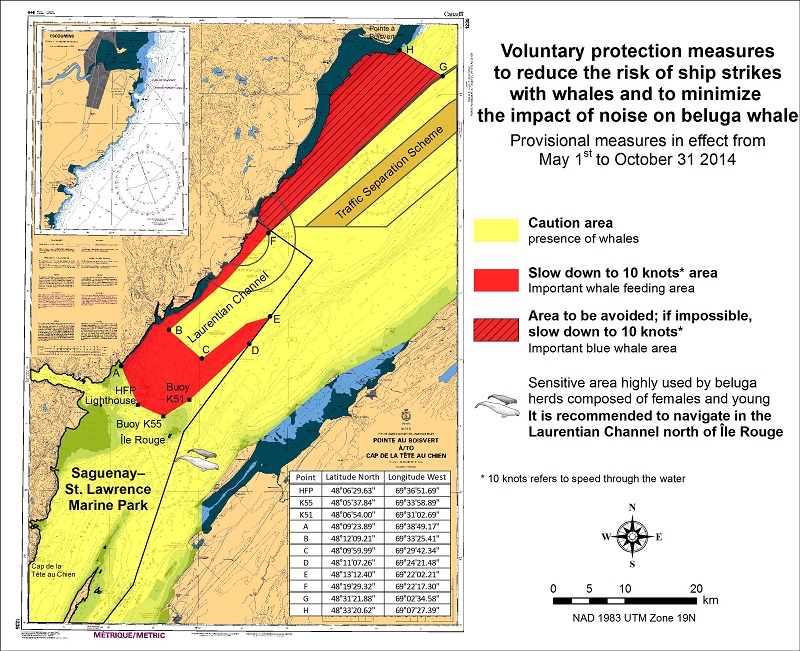
*401 SAGUENAY-ST. LAWRENCE MARINE PARK AND SURROUNDING WATERS - WHALE PROTECTION
The waters in and around the Saguenay-St. Lawrence Marine Park are well known for their resident threatened beluga
population and the wide diversity of whales that migrate there to feed, particularly between April and November.
REGULATORY PROTECTION MEASURES
All whale species that are found in the St. Lawrence are protected under the Marine Mammal Regulations, pursuant to the
Fisheries Act. Within the boundaries of the Marine Park, specific measures are set out in the Marine Activities in the
Saguenay–St. Lawrence Marine Park Regulations, pursuant to the Act Establishing the Saguenay-St. Lawrence Marine Park.
Any collision with a marine mammal within the Marine Park must immediately be reported to a park warden at 1-866-508-9888.
For collisions that occur outside the Marine Park or for any situation involving a marine mammal that is dead or in trouble,
contact the emergency network at 1-877-722-5346 or on channel 16.(see section 5C of the Annual Edition of the Notices to Mariners – April 2014 to March 2015).
VOLUNTARY PROTECTION MEASURES
Provisional measures in effect from May 1 to October 31, 2014
These measures apply to merchant vessels and cruise ships between Pointe à Boisvert and Cap de la Tête au Chien to prevent
collisions with whales (see link below to view map). These measures should only be taken when they will not jeopardize navigational safety.
Caution area (yellow area): To reduce the risk of collisions with whales that can be present anywhere in this area,
heightened vigilance is critical for navigators. Posting a lookout is recommended in order to increase the chances of
seeing the whales and thus taking necessary measures to avoid them. If bypassing the whales is not possible, slow down a
nd wait for the animals to move away to a distance greater than 400 meters (0.215 nautical miles) before resuming original speed.
It is more difficult to see the animals at night therefore increased caution is recommended.
Slow down to 10 knots area (red area): To reduce the risk of collisions with whales in this feeding area, it is recommended that vessels slow down to
a maximum speed through the water of 10 knots and post a lookout. It is further recommended to remain in the Laurentian Channel
to the north of île Rouge to minimize the impact of noise in a sensitive area south of this island, which is highly frequented
by herds of beluga whales composed of females and young.
Area to be avoided (hatched red area): To reduce noise and the risk of collisions with whales, vessels should avoid
transiting through this area which is highly frequented by blue whales, an endangered species. If the area cannot be avoided,
slow down to a maximum speed through the water of 10 knots.
See attached map:
*402 CANADIAN HYDROGRAPHIC SERVICE - NAUTICAL CHARTS.
| CHARTS | MAIN TITLE | SCALE | PUBLISHED | CAT# | PRICE | |
| New Charts | ||||||
| 1201 | Saint-Fulgence à/to Saguenay | 1:15000 | 07-FEB-2014 | 1 | ||
| 3977 | Douglas Channel | 1:80000 | 27-DEC-2013 | 20.00 | ||
| New Editions | ||||||
| 3419 | Esquimalt Harbour | 1:5000 | 13-DEC-2013 | 2 | 20.00 | |
| 3936 | Fitz Hugh Sound to/à Lama Passage | 1:40000 | 21-MAR-2014 | 2 | ||
| 4266 | Sydney Harbour | 1:20000 | 28-FEB-2014 | 1 | 20.00 | |
| 7950 | Jones Sound,Norwegian Bay and Queens Channel | 1:500000 | 21-JUN-2013 | 4 | 20.00 | |
| Charts Permanently Withdrawn | ||||||
| 1209 | Saint-Fulgence à/to Rivière Shipshaw | |||||
| 3743 | Douglas Channel | |||||
*403 CANADIAN HYDROGRAPHIC SERVICE - ELECTRONIC NAVIGATIONAL CHARTS.
| NEW PRODUCTS | |
| S-57 ENC NUMBER | CHART TITLE |
| CA370603 | Douglas Channel |
| CA370720 | Nootka Sound to/à Quatsino Sound (part 2 of 2) |
| CA370721 | Douglas Channel |
| CA376363 | Cut Throat Island to/à Quaker Hat |
| CA470604 | Douglas Channel - Central Portion/Partie Centrale |
| CA473456 | Approaches to/à Koojesse Inlet |
| CA476323 | Great Bay de l'Eau and Approaches/et les approches |
| CA476365 | Holton Harbour |
| CA476366 | Ice Tickle and /et Indian Harbour |
| CA570715 | Prince Rupert Harbour (part 2 of 2) |
| CA570716 | Trail Bay |
| CA570717 | Tsowwin Narrows |
| CA570718 | Welcome Bay |
| CA570719 | Port Mellon |
| CA576324 | Harbour Breton |
| CA576364 | Cut Throat Harbour and/et East Harbour |
| CA579237 | Saint-Fulgence à/to Saguenay |
| WITHDRAWN PRODUCTS | |
| CA470349 | Burke Channel |
| CA570066 | Venn Passage |
| CA570067 | Porpoise Harbour, Ridley Island and Approaches/et les approches |
| CA570068 | Morse Basin and/et Denise Inlet |
| CA570126 | Butze Rapids |
| CA579077 | Saint-Fulgence à/to Rivière Shipshaw |
| CA579095 | Chicoutimi à Rivière Shipshaw - Continuation A |
*404 CANADIAN HYDROGRAPHIC SERVICE - RASTER DIGITAL CHARTS (BSB V4).
| CHARTS | MAIN TITLE | SCALE | PUBLISHED |
| New Charts | |||
| R/M7184 | Broughton Island and Approaches/et les Approches | 1:50000 | 31-AUG-2012 |
| New Editions | |||
| R/M1310 | Port de Montréal | 1:15000 | 10-JAN-2014 |
| R/M3412 | Victoria Harbour | 1:12000 | 22-NOV-2013 |
| R/M4440 | Îles Sainte-Marie à/to Île à la Brume | 1:75000 | 19-JUL-2013 |
| R/M4722 | Terrington Basin | 1:6000 | 25-OCT-2013 |
*405 TRANSPORT CANADA - ACCEPTANCE OF NAUTICAL PUBLICATIONS IN ELECTRONIC FORM IN CANADA.
- The Charts and Nautical Publication Regulations, 1995 (CNPR) require the carriage and use of several nautical publications. Many nautical publications in Canada are now available in electronic form and can be downloaded from the internet in PDF (chart catalogue, Monthly Notices to Mariners (NOTMARS), List of Lights, Buoys and Fog Signal, Annual Edition of Notices to Mariners, Radio aids to Marine Navigation, CCG Ice Navigation in Canadian Waters). Some vessels may carry publications in electronic form issued by another Administration (i.e., Admiralty Digital Publications) as per CNPR subsection 6(3).
- IMO circular entitled IMO requirements on carriage of publications on board ships (MSC-MEPC.2/Circ.2) allows electronic publications provided they have been issued by the IMO, an Administration or an organization authorized by an Administration. The electronic document should also “be treated in accordance with the document control procedures in the ship’s SMS including procedures for timely update.” However, as an exception, IMO does require the International Code of Signals and the IAMSAR - Volume III must be always available in hard copy to ensure accessibility and portability for emergency use.
- Under SOLAS, charts and nautical publications in electronic form can be used to meet SOLAS V carriage requirements provided suitable back-up arrangements are in place.
- The CNPR provide detailed requirements for nautical publications. Electronic nautical publications must meet the same requirements as the hard copies.
For example;- The publication must be published, or issued, by the appropriate authority,
- The publication must be complete for the area to be navigated and up to date.
There should be an appropriate back-up onboard. The primary system should have an emergency source of power.
Updates should be applied to both the primary and back-up system as soon as practical. When in port, they should be applied prior to passage planning and commencement of the voyage.
As the publications required by the CNPR must be on board, simply being able to access the publications through the internet would not be considered on board and therefore not acceptable. However, publications downloaded and saved on board or hard copies printed from official internet sources would be acceptable.
*406 TRANSPORT CANADA – SHIP SAFETY BULLETIN.
This is to notify you that a new Ship Safety Bulletin has recently been posted to the Transport Canada website at:
http://www.tc.gc.ca/eng/marinesafety/bulletins-menu.htm/
To go online to view or download this bulletin, please click on the link below:
Subject: Proper Technical Maintenance of Freight Containers and Safe Stuffing Practices
Issue: Bulletin No.: 01/2014
Date: 2014-03-11
Link: http://www.tc.gc.ca/eng/marinesafety/bulletins-2014-01-eng.htm
Sign yourself up for e-Bulletin to receive an e-mail notice each time a new Ship Safety Bulletin is published on our
Web site.
Contact us at: marinesafety-securitemaritime@tc.gc.ca or 1-855-859-3123 (Toll Free).
*407 CANADIAN COAST GUARD PUBLICATION - NEW EDITION OF THE ANNUAL EDITION OF NOTICES TO MARINERS – 2014.
The 2014 edition of the Annual Edition of Notices to Mariners publication is now available for download,
free of charge, on the NOTMAR web site at:
http://www.notmar.gc.ca/go.php?doc=eng/services/annual/default-eng.
Paper copies of the publication will no longer be sold.
Amendments to this publication are advertised in the Section 1 of the monthly edition of Notices to Mariners http://www.notmar.gc.ca.
The 2014 edition has been revised up to Edition 12, 2013 and supersedes the 2013 edition.
*408 CANADIAN COAST GUARD - LIST OF CHARTS AND REFERENCE CHARTS (SECTION I) AFFECTED BY TEMPORARY AND PRELIMINARY NOTICES.
IN EFFECT MARCH 28, 2014
(REVISED AND PROMULGATED QUARTERLY)
| 2305 | 1204(P)/08 |
| 4124 | 307(P)/14 |
| 4201 | 509(P) /13 |
| 4233 | 210(P)/12 |
| 4243 | 711(P)/13; 308(P)/14 |
| 4266 | 608(P)/12, 609(P)/12 |
| 4279 | 1210(P)/13 |
| 4281 | 1111(P)/11 |
| 4340 | 305(P) /14; 306(P) /14 |
| 4377 | 405(P)/13 |
| 4386 | 1107(P)/13; 1108(P)/13 |
| 4396 | 510(P)/13 |
| 4449 | 1211(P)/13; 106(P)/14 |
| 4450 | 1005(P)/13; 1006(P)/13 |
| 4466 | 109(P)/14 |
| 4509 | 114(P)/14 |
| 4512 | 1205(P) /13;115(P)/14 |
| 4522 | 1103(T) /13; 1207(T) /13; |
| 4596 | 1209(T) /13; |
| 4639 | 113(P)/14 |
| 4642 | 111(P)/14 |
| 4644 | 112(P)/14 |
| 4669 | 116(P)/14 |
| 4670 | 1206(T) /13; |
| 4830 | 1104(T) /13; |
| 4844 | 110(P)/14 |
| 4905 | 204(P) /14 |
| 4909 | 613(P)/12, 810(P)/12; 205(P) /14; 206 (P) /14; 207(P) /14; 304(P) /14 |
| 4911 | 811(P)/12, 612(P)/13 |
| 4921 | 713(P)/13 |
| 5051 | 1208(T) /13; |
| 6267 | 112(P)/06 |
| US14884 | 715(T)13 |
*409 CANADIAN HYDROGRAPHIC SERVICE – SAILING DIRECTIONS – ARC 402 — EASTERN ARCTIC, FIRST EDITION, 2014 IS NOW AVAILABLE AS A PRINT-ON-DEMAND (POD) PRODUCT.
Sailing Directions booklet ARC 402 — Eastern Arctic, First Edition, 2014 is now available as a Print-on-Demand (POD) product. This new booklet cancels and replaces Sailing Directions, Arctic Canada, Volume II, Fourth Edition, 1985 and the remainder of Sailing Directions, Arctic Canada, Volume 3, Fifth Edition, 1994. POD booklets are corrected through Section 4 of Notices to Mariners up to the date of printing. The price of ARC 402 — Eastern Arctic, First Edition, 2014, is $26.95. Advance orders may be made through any Chart Dealer.
*410 CAPE PINE TO/À RENEWS HARBOUR - FOG SIGNALS DISCONTINUED
Reference: Notice 110(P) /2014 is now cancelled (Chart 4844).
(N2014-018; 019)
*411 GREAT ST. LAWRENCE HARBOUR AND/ET LAMALINE HARBOUR - FOG SIGNALS DISCONTINUED.
Reference: Notice 111(P) /2014 is now cancelled (Chart 4642).
(N2014-020; 021)
*412 BAY D'ESPOIR AND/ET HERMITAGE BAY - FOG SIGNAL DISCONTINUED.
Reference: Notice 112(P) /2014 is now cancelled (Chart 4644).
(N2014-022)
*413 GARIA BAY AND/ET LE MOINE BAY - FOG SIGNAL DISCONTINUED.
Reference: Notice 113(P) /2014 is now cancelled (Chart 4639).
(N2014-023)
*414 PISTOLET BAY - FOG SIGNAL DISCONTINUED.
Reference: Notice 114(P) /2014 is now cancelled (Chart 4509).
(N2014-024)
*415 QUIRPON HARBOUR AND APPROACHES/ET LES APPROCHES - FOG SIGNAL DISCONTINUED.
Reference: Notice 115(P) /2014 is now cancelled (Chart 4512).
(N2014-026)
*416 BAY OF ISLANDS – FOG SIGNAL DISCONTINUED.
Reference: Notice 1107(P) /2013 is now cancelled (Chart 4386)
(N2014-017)
417 RED BAY - FOG SIGNAL DISCONTINUED
Reference: Notice 116(P) /2014 is now cancelled (Chart 4669)
(N2014-025)
*418 GRADN MANAN - LIGHT AND BELL BOUY TO BE DISCONTINUED
ReferenceChart 4340
The Canadian Coast Guard proposes to permanently discontinue the following Aid to navigation:
North Shoal light and bell buoy X2, LL 5.6 (44° 32' 05.6"N 67° 06' 41.1"W)
Comments on this action are solicited from mariners and other interested parties.
Comments should be directed to the following within three months from the date of this notice:
Regional Superintendent,
Aids to Navigation & Waterways,
Canadian Coast Guard,
PO Box 5667,
St. John’s, NL, A1C 5X1
Telephone: 709-772-5195,
Email: LlewellynD@DFO-MPO-GC.CA
Any objections raised must state the facts on which they are based and should include supporting information on safety, commerce and public benefit.
(F2014-008)
*419 TUSKET ISLANDS TO/À CAPE ST. MARYS – LIGHT BOUY DISCONTINUED.
Reference: Notice 711(P)/2013 is now cancelled (Chart 4243)
(F2014-007)
*420(P) SYDNEY HARBOUR - LIGHT BOUY TO BE DISCONTINUED.
Reference Chart: 4266
The Canadian Coast Guard proposes to permanently discontinue the following Aid to navigation:
Point Edward Light Buoy S8; LL 781 (46° 11' 29"N 60° 13' 31"W).
Comments on this action are solicited from mariners and other interested parties.
Comments should be directed to the following within three months from the date of this notice:
Regional Superintendent,
Aids to Navigation & Waterways,
Canadian Coast Guard,
PO Box 5667,
St. John’s, NL, A1C 5X1
Telephone: 709-772-5195,
Email: LlewellynD@DFO-MPO-GC.CA
Any objections raised must state the facts on which they are based and should include supporting information on safety, commerce and public benefit.
(G2014-024)
*421(P) DÉTROIT DE NORTHUMBERLAND/NORTHUMBERLAND STRAIT (PARTIE OUEST/WESTERN PORTION) - LIGHT BOUY TO BE DISCONTINUED.
Reference Chart: 4909
The Canadian Coast Guard proposes to permanently discontinue the following Aid to navigation:
Bouctouche Harbour light buoy XV2; LL 1119.55 (46° 27' 03"N 64° 35' 45"W)
Comments on this action are solicited from mariners and other interested parties.
Comments should be directed to the following within three months from the date of this notice:
Regional Superintendent,
Aids to Navigation & Waterways,
Canadian Coast Guard,
PO Box 5667,
St. John’s, NL, A1C 5X1
Telephone: 709-772-5195,
Email: LlewellynD@DFO-MPO-GC.CA
Any objections raised must state the facts on which they are based and should include supporting information on safety, commerce and public benefit.
(G2014-027)
*422 BOUCTOUCHE HARBOUR NEW BRUNSWICK – INFORMATION REGARDING AIDS TO NAVIGATION.
The Canadian Coast Guard proposes changes to the following Aids to navigation:
Discontinue Bouctouche Bar light and bell buoy X17, LL 1125.5 (46° 31' 36"N 64° 32' 54"W).
Establish Bouctouche Harbour East Cardinal light buoy, Q(3) 10s, marked XVB, LL 1119.1 in 46° 25' 15.5''N 64° 36' 09.3''W (approx.).
Establish Bouctouche Harbour East Cardinal light buoy, VQ(3) 5s, marked XVA, LL 1119.2, 46° 27' 47.82"N, 64° 35' 40.98''W (approx.).
Discontinue Bouctouche Harbour green can buoy XV3, LL 6125.1 (46° 27' 05"N 64° 36' 46"W).
Replace Bouctouche Harbour red conical buoy, XV4 (46° 27' 09.5"N 64° 37' 02"W) with Bouctouche Harbour light buoy,
marked XV4, QR, LL 1119.64 and reposition to 46° 27' 8.28"N 64° 36' 33.24"W.
Replace Bouctouche Harbour red conical buoy XV6 (46° 27' 12.7"N 64° 37' 20.7"W) with Bouctouche Harbour light buoy,
marked XV6, FLR, LL 1119,65, remain on the same position.
Reposition Bouctouche Harbour red conical buoy XV8 from 46° 27' 09.5"N 64° 37' 02"W to 46° 27' 15.66"N 64° 37' 46.38"W.
Discontinue Bouctouche Harbour green light buoy XV9 (46° 27' 21.2"N 64° 38' 11.8"W).
Establish Bouctouche Harbour light buoy, QR, marked XV10, LL 1119.3 in 46° 27' 21.2"N 64° 38' 11.8"W.
Reposition Bouctouche Harbour red conical buoy XV12 from 46° 27' 27"N 64° 38' 23"W to 46° 27’ 32.34”N,64° 38' 33.78''W.
Establish Bouctouche Harbour green conical buoy, marked XV13, LL 1119.4 in position 46° 27' 30.54''N 64° 38' 36.48''W.
Reposition Bouctouche Harbour red conical buoy XV14 from 46° 27' 41"N 64° 38' 42"W to 46° 27' 44.22''N, 64° 38' 49.56''W.
Replace Bouctouche Harbour green can buoy, XV15 (46° 27' 41"N 64° 38' 50.5"W) with Bouctouche Harbour light buoy, FlG,
marked XV15, LL 1125.19 and reposition to 46° 27' 41.46''N 64° 38' 52.86''W.
Replace Bouctouche Harbour red conical buoy XV16 (46° 27' 50.5"N 64° 38' 47.5"W) with Bouctouche Harbour light buoy,
FlR, marked XV16, , LL 1125.17 and reposition to 46° 27'’ 56.64''N 64° 39' 5.94''W
Establish Bouctouche Harbour green conical buoy, marked XV17 in 46° 27' 54.06''N 64° 39' 9.42''W.
Reposition Bouctouche Harbour red conical buoy XV18 from 46° 28' 10"N 64° 39' 15.5"W to 46° 28' 8.10''N 64° 39' 21.24''W (approx).
Replace Bouctouche Harbour green can buoy XV19 (46° 28' 09"N 64° 39' 24.5"W) with Bouctouche Harbour light buoy, FlG, marked XV19,
LL 1125.21 and reposition to 46° 28' 5.70''N 64° 39' 24.36''W. Approx.
Establish Bouctouche Harbour conical light buoy, marked XV20, LL 1125.18 in 46° 28' 19.92''N, 64° 39' 36.54''W (approx).
Reposition Bouctouche Harbour green can buoy XV21 from 46° 28' 22"N 64° 39' 43"W to 46° 28' 26.34''N 64° 39' 51.12''W (approx).
Replace Bouctouche Harbour green can buoy XV23 (46° 28' 34"N 64° 40' 03"W) with Bouctouche Harbour light buoy, QG,
marked XV23, LL 1125.23, QG, remain on the same position.
Discontinue Bouctouche Harbour stakes - 34 (Red) STK34 (46° 28' 30"N 64° 40' 06"W) (approx). - Replaced with buoys.
Discontinue Bouctouche Harbour stakes - 14 (Green) STK14 (46° 28' 12"N 64° 40' 12"W) (approx). - Replaced with buoys.
Establish Bouctouche Harbour light buoy, FlR, marked XV26, LL 1125.24, in 46° 28' 40.02''N 64° 40' 13.68''W (approx).
Establish Bouctouche Harbour green buoy, marked XV27, in 46° 28' 37.74''N 64° 40' 15.84''W (approx).
Establish Bouctouche Harbour red buoy, marked XV28, in 46° 28' 29.00''N 64° 40' 28.80''W (approx).
Establish Bouctouche Harbour light buoy, FlG, marked XV29, LL 1125.25, in 46° 28' 37.14''N 64° 40' 27.30''W (approx).
Establish Bouctouche Harbour red buoy, marked XV30, in 46° 28' 36.18''N 64° 40' 41.88''W (approx).
Establish Bouctouche Harbour green buoy, marked XV31, in 46° 28' 34.26''N 64° 40' 40.68''W (approx).
Establish Bouctouche Harbour light buoy, FlR, marked XV32 LL 1125.26, in 46° 28' 32.94''N 64° 40' 54.42''W (approx).
Establish Bouctouche Harbour green buoy, marked XV33, in 46° 28' 30.90''N 64° 40' 53.88''W (approx).
Establish Bouctouche Harbour red buoy, marked XV34, in 46° 28' 29.34''N 64° 41' 6.66''W (approx).
Establish Bouctouche Harbour green buoy, marked XV35, in 46° 28' 27.36''N 64° 41' 5.52''W (approx).
Establish Buctouche Harbour light buoy, FlR, marked XV36, LL 1125.27 in 46° 28' 25.80''N 64° 41' 18.96''W (approx).
Establish Bouctouche Harbour light buoy, FLG, marked XV37 LL 1125.28, in 46° 28' 24.24''N 64° 41' 18.18''W (approx).
Establish Bouctouche Harbour red buoy, marked XV38, in 46° 28' 23.76''N 64° 41' 31.26''W (approx)
Establish Bouctouche Harbour green buoy, marked XV39, in 46° 28' 22.14''N 64° 41' 30.84''W (approx).
Establish Bouctouche Harbour red buoy, marked XV40, in 46° 28' 21.42''N 64° 41' 43.62''W (approx).
Establish Bouctouche Harbour light buoy, FlG, marked XV41, LL 1125.29, in 46° 28' 19.68''N 64° 41' 42.96''W (approx).
Establish Bouctouche Harbour green buoy, marked XV42, in 46° 28' 15.78''N 64° 41' 53.70''W approx.
Establish Bouctouche Harbour red buoy, marked XV43, in 46° 28' 17.64''N 64° 41' 54.90''W (approx).
Establish Bouctouche Harbour green buoy, marked XV45, in 46° 28' 13.86''N 64° 42' 5.64''W (approx).
Establish Buctouche Harbour red buoy, marked XV46, in 46° 28' 20.46''N 64° 42' 14.46''W (approx).
Establish Bouctouche Harbour green buoy, marked XV47, in 46° 28' 18.06''N 64° 42' 18.12''W (approx).
Establish Bouctouche Harbour red buoy, marked XV48, in 46° 28' 26.28''N 64° 42' 24.72''W (approx).
Establish Bouctouche Harbour green buoy, marked XV49, in 46° 28' 24.78''N 64° 42' 26.94''W (approx).
Establish Bouctouche Harbour light buoy, QG, marked XV51 LL 1125.30, in 46° 28' 26.70''N 64° 42' 32.22''W (approx).
Establish Bouctouche Harbour red buoy, marked XV52, in 46° 28' 28.68''N 64° 42' 35.94''W (approx).
Establish Bouctouche Harbour red buoy, marked XV54, in 46° 28' 28.56''N 64° 42' 44.70''W (approx).
Establish Bouctouche Harbour green buoy, marked XV55, in 46° 28' 27.48''N 64° 42' 44.82''W (approx).
Establish Bouctouche Harbour red buoy, marked XV56, in 46° 28' 28.68''N 64° 42' 51.30''W (approx).
Establish Bouctouche Harbour light buoy, QR, marked XV44 LL 1125.31, in 46° 28' 16.00''N 64° 42' 6.00''W (approx).
Discontinue Bouctouche Harbour buoy XV60 (46° 28' 16.00''N 64° 42' 06.00''W).
Maintain Bouctouche Harbour – 100 (green) STK100 (46° 29' 00''N 64° 40' 00''W) (approx).
Maintain Bouctouche Harbour - 100 (red) STK100 (46° 29' 00''N 64° 40' 00''W) (approx).
SECTION 2
CHART CORRECTIONS
| 1220 - Baie des Sept-Îles - New Edition - 11-MAY-2012 - NAD 1983 | |||
| 18-APR-2014 | LNM/D. 24-MAY-2013 | ||
| Add | depth of 0 metres 2 decimetres (See Chart No. 1, I10) This notice affects Electronic Navigational Chart: CA479006 |
50°09′59.4″N 066°26′06.0″W | |
| DFO(6408879-01) | |||
| Add | depth of 9 metres 5 decimetres (See Chart No. 1, I10) This notice affects Electronic Navigational Chart: CA379028, CA479006 |
50°11′39.4″N 066°16′10.0″W | |
| DFO(6408906-01) | |||
| 1221 - Pointe de Moisie à/to Île du Grand Caouis - New Edition - 07-JAN-2005 - NAD 1983 | |||
| 18-APR-2014 | LNM/D. 28-JAN-2011 | ||
| Add | depth of 9 metres 5 decimetres (See Chart No. 1, I10) This notice affects Electronic Navigational Chart: CA379028, CA479006 |
50°11′39.4″N 066°16′10.0″W | |
| DFO(6408906-01) | |||
| 1317 - Continuation A - New Edition - 22-JUN-2012 - NAD 1983 | |||
| 18-APR-2014 | LNM/D. 22-NOV-2013 | ||
| Amend | vertical clearance of 51 metres, to read 50 metres (See Chart No. 1, D20) This notice affects Electronic Navigational Chart: CA479082 |
46°50′39.8″N 071°03′28.0″W | |
| DFO(6408894-01) | |||
| Amend | vertical clearance of *28 metres, to read *35 metres (See Chart No. 1, D20) This notice affects Electronic Navigational Chart: CA479082 |
46°50′19.4″N 071°03′20.8″W | |
| DFO(6408894-02) | |||
| 1430 - Lac Saint-Louis - New Chart - 16-APR-2010 - NAD 1983 | |||
| 25-APR-2014 | LNM/D. 08-NOV-2013 | ||
| Amend | Iso Bu 2s9m6M to read Iso Bu 6s8m7M against front leading light (See Chart No. 1, P16) |
45°24′19.5″N 073°57′26.0″W | |
| (Q2014002) LL(1227) DFO(6408881-02) | |||
| Amend | F Bu 12m6M to read Iso Bu 6s13m7M against rear leading light (See Chart No. 1, P16) This notice affects Electronic Navigational Chart: CA479228 |
45°24′16.9″N 073°57′21.0″W | |
| (Q2014003) LL(1228) DFO(6408882-02) | |||
| Amend | bearing from seaward 127½° to read 127° (See Chart No. 1, Pe) This notice affects Electronic Navigational Chart: CA479228 |
45°24′32.0″N 073°57′46.1″W | |
| (Q2014003) LL(1228) DFO(6408882-03) | |||
| 1430 - Sainte-Anne-de-Bellevue - New Chart - 16-APR-2010 - NAD 1983 | |||
| 25-APR-2014 | LNM/D. 08-NOV-2013 | ||
| Amend | Iso Bu 2s9m to read Iso Bu 6s8m against front leading light (See Chart No. 1, P16) This notice affects Electronic Navigational Chart: CA579230 |
45°24′19.5″N 073°57′26.0″W | |
| (Q2014002) LL(1227) DFO(6408881-01) | |||
| Amend | F Bu 12m to read Iso Bu 6s13m against rear leading light (See Chart No. 1, P16) This notice affects Electronic Navigational Chart: CA579230 |
45°24′16.9″N 073°57′21.0″W | |
| (Q2014003) LL(1228) DFO(6408882-01) | |||
| 1509 - Île Bizard à/to Pont-Viau A-B - Sheet/Feuille 1 - New Edition - 19-APR-2013 - NAD 1983 | |||
| 04-APR-2014 | |||
| Amend | vertical clearance of 5 metres, to read 4 metres 8 decimetres (See Chart No. 1, D20) This notice affects Electronic Navigational Chart: CA579173, CA579176 |
45°31′26.2″N 073°45′13.3″W | |
| DFO(6408878-01) | |||
| 1510 - Lac Saint-Louis à/to Carillon - Compartment B-C - Sheet/Feuille 1 - New Edition - 04-JUN-2010 - NAD 1983 | |||
| 25-APR-2014 | LNM/D. 15-NOV-2013 | ||
| Amend | Iso Bu 2s9m6M to read Iso Bu 6s8m7M against front leading light (See Chart No. 1, P16) |
45°24′19.5″N 073°57′26.0″W | |
| (Q2014002) LL(1227) DFO(6408881-02) | |||
| Amend | F Bu 12m6M to read Iso Bu 6s13m7M against rear leading light (See Chart No. 1, P16) This notice affects Electronic Navigational Chart: CA479228 |
45°24′16.9″N 073°57′21.0″W | |
| (Q2014003) LL(1228) DFO(6408882-02) | |||
| Amend | bearing from seaward 127½° to read 127° (See Chart No. 1, Pe) This notice affects Electronic Navigational Chart: CA479228 |
45°24′32.0″N 073°57′46.1″W | |
| (Q2014003) LL(1228) DFO(6408882-03) | |||
| Replace | black and yellow North cardinal spar buoy, marked ANSE with black and yellow North cardinal pillar buoy, marked ANSE (See Chart No. 1, Q130.3,Q23) This notice affects Electronic Navigational Chart: CA479202 |
45°26′24.4″N 074°01′58.8″W | |
| (Q2014014) DFO(6408895-01) | |||
| 1510 - Baie de Vaudreuil à/to Laval - Compartment A-B - Sheet/Feuille 2 - New Edition - 04-JUN-2010 - NAD 1983 | |||
| 25-APR-2014 | LNM/D. 15-NOV-2013 | ||
| Replace | black and yellow North cardinal spar buoy, marked ANSE with black and yellow North cardinal pillar buoy, marked ANSE (See Chart No. 1, Q130.3,Q23) This notice affects Electronic Navigational Chart: CA479202 |
45°26′24.4″N 074°01′58.8″W | |
| (Q2014014) DFO(6408895-01) | |||
| 1515 - Becketts Creek à/to Ottawa - Sheet/Feuille 2 - New Chart - 24-JUL-1998 - NAD 1983 | |||
| 18-APR-2014 | LNM/D. 07-MAR-2014 | ||
| Replace | red, green and red starboard bifurcation lighted spar buoy Fl (2+1) R, marked GAT with red,
green and red starboard bifurcation lighted pillar Fl (2+1) R, marked GAT (See Chart No. 1, Qi) |
45°27′12.0″N 075°41′35.0″W | |
| (Q2014015) LL(1296.45) DFO(6408896-01) | |||
| 4016 - Saint-Pierre to/à St. John's - New Edition - 06-JUN-2003 - NAD 1983 | |||
| 25-APR-2014 | LNM/D. 18-APR-2014 | ||
| Delete | legend Fog Sig against light (See Chart No. 1, R1, R20) This notice affects Electronic Navigational Chart: CA276091, CA376164 |
46°50′48.0″N 055°47′51.5″W | |
| (N2014020) LL(76) DFO(6306716-01) | |||
| Delete | legend Fog Sig against light (See Chart No. 1, R1, R20) This notice affects Electronic Navigational Chart: CA276274 |
47°38′35.9″N 056°08′57.6″W | |
| (N2014022) LL(134) DFO(6306718-01) | |||
| 18-APR-2014 | LNM/D. 27-DEC-2013 | ||
| Delete | legend Fog Sig against light (See Chart No. 1, R1, R20) This notice affects Electronic Navigational Chart: CA276091, CA376106, CA576107 |
46°41′25.1″N 053°24′05.7″W | |
| (N2014019) LL(5) DFO(6306714-02) | |||
| 4017 - Cape Race to/à Cape Freels - New Edition - 07-MAR-2003 - NAD 1983 | |||
| 18-APR-2014 | LNM/D. 27-DEC-2013 | ||
| Delete | legend Fog Sig against light (See Chart No. 1, R1, R20) This notice affects Electronic Navigational Chart: CA276091, CA376106, CA576107 |
46°41′25.1″N 053°24′05.7″W | |
| (N2014019) LL(5) DFO(6306714-02) | |||
| 4020 - Strait of Belle Isle/Détroit de Belle Isle - New Edition - 26-JUL-2002 - NAD 1983 | |||
| 25-APR-2014 | LNM/D. 25-NOV-2011 | ||
| Delete | legend Fog Sig 30s against light (See Chart No. 1, R1, R20) This notice affects Electronic Navigational Chart: CA376094 |
51°37′43.0″N 055°54′15.8″W | |
| (N2014024) LL(223) DFO(6306720-01) | |||
| Delete | legend Fog Sig 30s against light (See Chart No. 1, R1, R20) This notice affects Electronic Navigational Chart: CA376094 |
51°43′35.7″N 056°26′00.0″W | |
| (N2014025) LL(230) DFO(6306720-02) | |||
| Delete | legend Fog Sig 30s against light (See Chart No. 1, R1, R20) This notice affects Electronic Navigational Chart: CA376094 |
51°38′21.9″N 055°25′32.7″W | |
| (N2014026) LL(225) DFO(6306720-03) | |||
| 4023 - Northumberland Strait / Détroit de Northumberland - New Edition - 27-DEC-2002 - NAD 1983 | |||
| 18-APR-2014 | LNM/D. 07-FEB-2014 | ||
| Amend | sector light Fl(2)RWG to read FRWG against light (See Chart No 1 P40.1) This notice affects Electronic Navigational Chart: CA276286, CA376062 |
46°57′51.4″N 064°49′54.9″W | |
| (G2014023) LL(1159.6) DFO(6306706-01) | |||
| 4047 - St. Pierre Bank/Banc de Saint-Pierre to/au Whale Bank/Banc de la Baleine - New Edition - 09-OCT-1998 - NAD 1983 | |||
| 25-APR-2014 | LNM/D. 18-APR-2014 | ||
| Delete | legend Fog Sig against light (See Chart No. 1, R1, R20) This notice affects Electronic Navigational Chart: CA276091, CA376164 |
46°50′48.0″N 055°47′51.5″W | |
| (N2014020) LL(76) DFO(6306716-01) | |||
| 18-APR-2014 | LNM/D. 03-FEB-2012 | ||
| Delete | legend Fog Sig against light (See Chart No. 1, R1, R20) This notice affects Electronic Navigational Chart: CA276091, CA376106, CA576107 |
46°41′25.1″N 053°24′05.7″W | |
| (N2014019) LL(5) DFO(6306714-02) | |||
| 4243 - Tusket Islands to/à Cape St. Marys - New Edition - 11-OCT-2002 - NAD 1983 | |||
| 18-APR-2014 | LNM/D. 11-NOV-2011 | ||
| Delete | red starboard hand lighted spar buoy FlR, marked NU2. (See Chart No. 1, Qf) This notice affects Electronic Navigational Chart: CA376018 |
43°59′12.1″N 066°09′40.4″W | |
| (F2014007) LL(250.01) DFO(6306710-01) | |||
| 4245 - Yarmouth Harbour and Approaches/et les approches - New Edition - 19-NOV-1999 - NAD 1983 | |||
| 04-APR-2014 | LNM/D. 05-AUG-2011 | ||
| Delete | depth of 4 metres, 4 decimetres (See Chart No. 1, I10) This notice affects Electronic Navigational Chart: CA576020 |
43°50′15.6″N 066°07′26.0″W | |
| DFO(6306707-02) | |||
| Replace | depth of 4 metres, 2 decimetres with depth of 3 metres, 9 decimetres (See Chart No. 1, I10) This notice affects Electronic Navigational Chart: CA576020 |
43°50′15.3″N 066°07′23.2″W | |
| DFO(6306707-03) | |||
| Add | depth of 3 metres, 4 decimetres (See Chart No. 1, I10) This notice affects Electronic Navigational Chart: CA576020 |
43°50′14.6″N 066°07′25.6″W | |
| DFO(6306707-04) | |||
| Delete | depth of 4 metres, 3 decimetres (See Chart No. 1, I10) This notice affects Electronic Navigational Chart: CA576020 |
43°50′14.6″N 066°07′27.6″W | |
| DFO(6306707-05) | |||
| Delete | depth of 4 metres, 5 decimetres (See Chart No. 1, I10) This notice affects Electronic Navigational Chart: CA576020 |
43°50′12.4″N 066°07′25.8″W | |
| DFO(6306707-06) | |||
| Add | depth of 3 metres, 5 decimetres (See Chart No. 1, I10) This notice affects Electronic Navigational Chart: CA576020 |
43°50′06.3″N 066°07′24.0″W | |
| DFO(6306707-07) | |||
| Delete | depth of 6 metres, 7 decimetres (See Chart No. 1, I10) This notice affects Electronic Navigational Chart: CA576020 |
43°50′00.9″N 066°07′27.4″W | |
| DFO(6306707-08) | |||
| Add | depth of 6 metres, 3 decimetres (See Chart No. 1, I10) This notice affects Electronic Navigational Chart: CA576020 |
43°50′01.2″N 066°07′27.0″W | |
| DFO(6306707-09) | |||
| 4245 - Yarmouth Wharves/Quais - New Edition - 19-NOV-1999 - NAD 1983 | |||
| 04-APR-2014 | LNM/D. 05-AUG-2011 | ||
| Affix | patch Download Patch - http://www.chs-shc.gc.ca/patches/4245P_20140404.pdf This notice affects Electronic Navigational Chart: CA576021 |
43°50′00.0″N 066°07′30.0″W | |
| DFO(6306707-01) | |||
| 4277 - Great Bras D'Or, St. Andrews Channel and/et St. Anns Bay - New Edition - 17-APR-1998 - NAD 1983 | |||
| 18-APR-2014 | LNM/D. 03-JAN-2014 | ||
| Delete | abandoned lighthouse with legend Lt Ho/Phare (Aband) This notice affects Electronic Navigational Chart: CA476063 |
46°20′12.4″N 060°17′30.6″W | |
| DFO(6306708-01) | |||
| 4509 - Cape Norman Bay and Cooks Harbour - New Edition - 06-JUN-2003 - Unknown | |||
| 25-APR-2014 | LNM/D. 06-AUG-2010 | ||
| Delete | legend Fog Sig 30s against light (See Chart No. 1, R1, R20) This notice affects Electronic Navigational Chart: CA376094 |
51°38′04.0″N 055°54′37.5″W | |
| (N2014024) LL(223) DFO(6306720-01) | |||
| 4509 - Pistolet Bay - New Edition - 06-JUN-2003 - Unknown | |||
| 25-APR-2014 | LNM/D. 06-AUG-2010 | ||
| Delete | legend Fog Sig 30s against light (See Chart No. 1, R1, R20) This notice affects Electronic Navigational Chart: CA376094 |
51°38′04.4″N 055°54′37.5″W | |
| (N2014024) LL(223) DFO(6306720-01) | |||
| 4512 - Quirpon Harbour and Approaches/et les approches - New Edition - 24-JAN-2003 - NAD 1983 | |||
| 25-APR-2014 | LNM/D. 04-SEP-2009 | ||
| Delete | legend Fog Sig 30s against light (See Chart No. 1, R1, R20) This notice affects Electronic Navigational Chart: CA376094 |
51°38′24.2″N 055°25′35.9″W | |
| (N2014026) LL(225) DFO(6306720-03) | |||
| 4625 - Burin Peninsula to/à Saint-Pierre - New Edition - 24-JAN-2003 - NAD 1983 | |||
| 25-APR-2014 | LNM/D. 03-JAN-2014 | ||
| Delete | legend Fog Sig 30s against light (See Chart No. 1, R1, R20) This notice affects Electronic Navigational Chart: CA276091, CA376164 |
46°50′48.0″N 055°47′51.5″W | |
| (N2014020) LL(76) DFO(6306716-01) | |||
| Delete | legend Fog Sig (See Chart No. 1, R1, R20) This notice affects Electronic Navigational Chart: CA376164 |
46°51′06.8″N 055°49′39.2″W | |
| (N2014021) LL(78.51) DFO(6306716-02) | |||
| 4639 - Garia Bay and/et Le Moine Bay - New Edition - 10-MAY-2002 - NAD 1983 | |||
| 25-APR-2014 | LNM/D. 03-JAN-2014 | ||
| Delete | legend Fog Sig 30s against light (See Chart No. 1, R1, R20) |
47°36′08.1″N 058°42′05.4″W | |
| (N2014023) LL(151.07) DFO(6306719-01) | |||
| 4639 - Rose Blanche - New Edition - 10-MAY-2002 - NAD 1983 | |||
| 25-APR-2014 | LNM/D. 03-JAN-2014 | ||
| Delete | legend Fog Sig 30s against light (See Chart No. 1, R1, R20) |
47°36′08.1″N 058°42′05.4″W | |
| (N2014023) LL(151.07) DFO(6306719-01) | |||
| 4642 - Lamaline Harbour - New Edition - 08-NOV-2002 - NAD 1983 | |||
| 25-APR-2014 | LNM/D. 18-MAR-2011 | ||
| Delete | legend Fog Sig 30s against light (See Chart No. 1, R1, R20) This notice affects Electronic Navigational Chart: CA276091, CA376164 |
46°50′48.0″N 055°47′51.5″W | |
| (N2014020) LL(76) DFO(6306716-01) | |||
| Delete | legend Fog Sig 20s (See Chart No. 1, R1, R20) This notice affects Electronic Navigational Chart: CA376164 |
46°51′06.8″N 055°49′39.2″W | |
| (N2014021) LL(78.51) DFO(6306716-02) | |||
| 4644 - Bay D'Espoir and/et Hermitage Bay - New Edition - 25-JUN-1999 - NAD 1983 | |||
| 25-APR-2014 | LNM/D. 28-SEP-2012 | ||
| Delete | legend Fog Sig 20s against light (See Chart No. 1, R1, R20) This notice affects Electronic Navigational Chart: CA276274 |
47°38′35.9″N 056°08′57.6″W | |
| (N2014022) LL(134) DFO(6306718-01) | |||
| 4653 - Bay of Islands - New Edition - 30-MAY-2003 - NAD 1983 | |||
| 18-APR-2014 | LNM/D. 24-SEP-2010 | ||
| Delete | legend Fog Sig (See Chart No. 1, R1, R20) This notice affects Electronic Navigational Chart: CA476190 |
49°07′18.1″N 058°24′27.1″W | |
| (N2014017) LL(191.5) DFO(6306713-01) | |||
| 4661 - Bear Head to/à Cow Head - New Edition - 04-JUL-2003 - NAD 1983 | |||
| 18-APR-2014 | LNM/D. 24-SEP-2010 | ||
| Delete | legend Fog Sig (See Chart No. 1, R1, R20) This notice affects Electronic Navigational Chart: CA476190 |
49°07′18.1″N 058°24′27.1″W | |
| (N2014017) LL(191.5) DFO(6306713-01) | |||
| 4669 - Red Bay - New Edition - 06-DEC-2002 - NAD 1983 | |||
| 25-APR-2014 | LNM/D. 27-FEB-2009 | ||
| Delete | legend Fog Sig 30s against light (See Chart No. 1, R1, R20) This notice affects Electronic Navigational Chart: CA376094 |
51°43′28.6″N 056°26′09.0″W | |
| (N2014025) LL(230) DFO(6306720-02) | |||
| 4731 - Forteau Bay to/à Domino Run - New Edition - 13-JUN-2003 - Unknown | |||
| 25-APR-2014 | LNM/D. 25-NOV-2011 | ||
| Delete | legend Fog Sig 30s against light (See Chart No. 1, R1, R20) This notice affects Electronic Navigational Chart: CA376094 |
51°37′44.6″N 055°54′19.8″W | |
| (N2014024) LL(223) DFO(6306720-01) | |||
| Delete | legend Fog Sig 30s against light (See Chart No. 1, R1, R20) This notice affects Electronic Navigational Chart: CA376094 |
51°43′28.6″N 056°26′09.0″W | |
| (N2014025) LL(230) DFO(6306720-02) | |||
| Delete | legend Fog Sig 30s against light (See Chart No. 1, R1, R20) This notice affects Electronic Navigational Chart: CA376094 |
51°38′21.9″N 055°25′32.7″W | |
| (N2014026) LL(225) DFO(6306720-03) | |||
| 4817 - Bay Bulls to/à St. Mary's Bay - New Edition - 23-AUG-2002 - NAD 1983 | |||
| 18-APR-2014 | LNM/D. 31-DEC-2010 | ||
| Delete | legend Fog Sig against light (See Chart No. 1, R1, R20) This notice affects Electronic Navigational Chart: CA276091, CA376106, CA576107 |
46°41′25.1″N 053°24′05.7″W | |
| (N2014019) LL(5) DFO(6306714-02) | |||
| 4827 - Hare Bay to/à Fortune Head - New Chart - 13-AUG-2004 - NAD 1983 | |||
| 25-APR-2014 | LNM/D. 03-JAN-2014 | ||
| Delete | legend Fog Sig 20s against light (See Chart No. 1, R1, R20) This notice affects Electronic Navigational Chart: CA276274 |
47°38′35.9″N 056°08′57.6″W | |
| (N2014022) LL(134) DFO(6306718-01) | |||
| 4844 - Cape Pine to/à Renews Harbour - New Edition - 08-MAR-2002 - NAD 1983 | |||
| 18-APR-2014 | LNM/D. 31-DEC-2010 | ||
| Delete | legend Fog Sig 30s against light (See Chart No. 1, R1, R20) This notice affects Electronic Navigational Chart: CA276091, CA376106, CA576107 |
46°41′25.1″N 053°24′05.7″W | |
| (N2014019) LL(5) DFO(6306714-02) | |||
| 4844 - Trepassey Harbour - New Edition - 08-MAR-2002 - NAD 1983 | |||
| 18-APR-2014 | LNM/D. 31-DEC-2010 | ||
| Delete | legend Fog Sig against light (See Chart No. 1, R1, R20) This notice affects Electronic Navigational Chart: CA576107 |
46°43′28.4″N 053°22′57.9″W | |
| (N2014018) LL(4) DFO(6306714-01) | |||
| Delete | legend Fog Sig 30s against light (See Chart No. 1, R1, R20) This notice affects Electronic Navigational Chart: CA276091, CA376106, CA576107 |
46°41′25.1″N 053°24′05.7″W | |
| (N2014019) LL(5) DFO(6306714-02) | |||
| 4906 - West Point à/to Baie de Tracadie - New Chart - 18-MAR-1988 - NAD 1983 | |||
| 18-APR-2014 | LNM/D. 03-JAN-2014 | ||
| Amend | sector light Fl(2)RWG to read FRWG against light (See Chart No 1 P40.1) This notice affects Electronic Navigational Chart: CA276286, CA376062 |
46°57′47.3″N 064°49′49.9″W | |
| (G2014023) LL(1159.6) DFO(6306706-01) | |||
| 4921 - Paspébiac - New Edition - 16-MAR-2012 - NAD 1983 | |||
| 04-APR-2014 | LNM/D. 06-DEC-2013 | ||
| Delete | depth of 2 metres 9 decimetres (See Chart No. 1, I10) This notice affects Electronic Navigational Chart: CA479073 |
48°00′36.3″N 065°15′03.4″W | |
| DFO(6408850-02) | |||
| Add | depth of 2 metres 3 decimetres> (See Chart No. 1, I10) This notice affects Electronic Navigational Chart: CA479073 |
48°00′37.1″N 065°15′04.0″W | |
| DFO(6408850-03) | |||
| Delete | depth of 3 metres 1 decimetre (See Chart No. 1, I10) This notice affects Electronic Navigational Chart: CA479073 |
48°00′19.0″N 065°14′42.5″W | |
| DFO(6408850-04) | |||
| Add | depth of 2 metres 5 decimetres (See Chart No. 1, I10) This notice affects Electronic Navigational Chart: CA479073 |
48°00′19.0″N 065°14′42.5″W | |
| DFO(6408850-05) | |||
| Delete | depth of 3 metres 0 decimetres (See Chart No. 1, I10) This notice affects Electronic Navigational Chart: CA479073 |
48°00′14.5″N 065°15′02.5″W | |
| DFO(6408850-07) | |||
| Delete | depth of 1 metre 2 decimetres (See Chart No. 1, I10) This notice affects Electronic Navigational Chart: CA479073 |
48°01′18.7″N 065°15′39.2″W | |
| DFO(6408850-08) | |||
| Add | depth of 2 metres 4 decimetres (See Chart No. 1, I10) This notice affects Electronic Navigational Chart: CA479073 |
48°00′14.5″N 065°15′02.5″W | |
| DFO(6408850-09) | |||
| Add | depth of 0 metres 9 decimetres (See Chart No. 1, I10) This notice affects Electronic Navigational Chart: CA479073 |
48°01′17.7″N 065°15′40.9″W | |
| DFO(6408850-10) | |||
| 4921 - Quai / Wharf Paspébiac-Ouest - New Edition - 16-MAR-2012 - NAD 1983 | |||
| 04-APR-2014 | LNM/D. 06-DEC-2013 | ||
| Affix | patch Download Patch - http://www.chs-shc.gc.ca/patches/AG4921_20140110.pdf This notice affects Electronic Navigational Chart: CA579074 |
48°01′24.0″N 065°15′24.0″W | |
| DFO(6408850-01) | |||
SECTION 3
RADIO AIDS TO MARINE NAVIGATION CORRECTIONS
*423 CANADIAN COAST GUARD PUBLICATION - AMENDMENT TO THE RADIO AIDS TO MARINE NAVIGATION (ATLANTIC, ST. LAWRENCE, GREAT LAKES, LAKE WINNIPEG AND EASTERN ARCTIC) PUBLICATION – 2013
Part 1 – Pages 3 of 10
AMEND
9. Automatic Identification System (AIS) - Installation of AIS Equipment in Eastern Canada
In 2012, the Canadian Coast Guard will commence Full Operational Condition (FOC) AIS service.
The Canadian Coast Guard AIS will cover most of Eastern Canada from the Strait of Belle Isle to the Bay of Fundy,
most of the Gulf of St. Lawrence, the St. Lawrence River and the Canadian Great Lakes. AIS service is now available
at the following Marine Communications and Traffic Services centres:
NL: Port-aux-Basques, Placentia; St. Anthony; St. John's.
NS: Halifax; Sydney.
NB: Saint John.
QC: Les Escoumins; Montréal; Québec; Rivière-au-Renard.
ON: Sarnia.
TO READ
9. Automatic Identification System (AIS) - Installation of AIS Equipment in Eastern Canada
In 2012, the Canadian Coast Guard will commence Full Operational Condition (FOC) AIS service.
The Canadian Coast Guard AIS will cover most of Eastern Canada from the Strait of Belle Isle to the Bay of Fundy,
most of the Gulf of St. Lawrence, the St. Lawrence River and the Canadian Great Lakes. AIS service is now available
at the following Marine Communications and Traffic Services centres:
NL: Port-aux-Basques, Placentia; St. Anthony; St. John's.
NS: Halifax; Sydney.
NB: Saint John.
QC: Les Escoumins; Montréal; Québec; Rivière-au-Renard.
ON: Sarnia.
Part 1 – Page 8 of 10
AMEND TABLE
TELEPHONE/FACSIMILE/TELEX DIRECTORY
| SERVICE | TELEPHONE NUMBER | FACSIMILE NUMBER | TELEX NUMBER | ANSWER BACK CODE | MMSI |
| Marine Communications and Traffic Services centre (call sign) | |||||
| HALIFAX, NS (VCS) | 902-426-9750 | 902-426-4483 | → 2101922510 | 003160016 | |
| IQALUIT, NU (VFF) Service available in English and in French |
867-979-5269 | 867-979-4264 | 063-15529 | 003160023 | |
| LABRADOR, (Goose Bay) NL (VOK) | 709-896-2252 | 709-896-8455 | 003160022 | ||
| LES ESCOUMINS, QC (VCF) Service available in English and in French |
418-233-2194 | 418-233-3299 | 003160026 | ||
| MONTRÉAL, QC (VFN) Service available in English and in French | 450-928-4544 | 450-928-4547 | 003160028 | ||
TO READ
TELEPHONE/FACSILILE/TELEX DIRECTORY
| SERVICE | TELEPHONE NUMBER | FACSIMILE NUMBER | TELEX NUMBER | ANSWER BACK CODE | MMSI |
| Marine Communications and Traffic Services centre (call sign) | |||||
| HALIFAX, NS (VCS) | 902-426-9750 | 902-426-4483 | → 2101922510 | 003160016 | |
| IQALUIT, NU (VFF) Service available in English and in French |
867-979-5269 | 867-979-4264 | 063-15529 | 003160023 | |
| LABRADOR, (Goose Bay) NL (VOK) | 709-896-2252 | 709-896-8455 | 003160022 | ||
| LES ESCOUMINS, QC (VCF) Service available in English and in French |
418-233-2194 | 418-233-3299 | 003160026 | ||
Part 2 – Pages 25 and 26 of 64
QUÉBEC, QUÉBEC – Marine Communications and Traffic Services Centre
AMEND TABLE
MCTS Québec / VCC – Ship/Shore Communications
| COMMUNICATION SITES LOCATED AT: | CHANNEL | TRANSMIT | RECEIVE | REMARKS |
| FREQUENCIES | FREQUENCIES | |||
| Lauzon 46°48’45”N 71°09’33”W |
Ch12 Ch16 Ch26 Ch70 |
|||
| Trois-Rivières 46°23’50”N 72°27’17”W |
Ch13 Ch16 Ch24 Ch70 |
|||
| Mont Bélair 46°49’22”N 71°29’45”W |
Ch13 Ch16 Ch85 Ch70 |
|||
| Montmagny ♦ 46°55’42”N 70°30’45”W |
Ch12 Ch16 Ch24 Ch70 |
|||
| Rivière-du-Loup 47°45’35”N 69°36’19”W |
Ch12 Ch16 Ch70 Ch85 |
|||
| Sorel 46°02’45”N 73°06’52”W |
Ch13 Ch16 |
MCTS Québec/VCC - Broadcasts
| TIME UTC | FREQUENCY | CONTENTS |
| Continuous | Ch21B Lauzon Rivière-du-Loup Ch83B Montmagny Trois-Rivières |
RADIOTELEPHONY:
|
Hourly weather observations for specific locations technical marine synopsis and MAFOR are available upon request
TO READ
MCTS Québec / VCC – Ship/Shore Communications
| COMMUNICATION SITES LOCATED AT: | CHANNEL | TRANSMIT | RECEIVE | REMARKS |
| FREQUENCIES | FREQUENCIES | |||
| Lauzon 46°48’45”N 71°09’33”W |
Ch12 Ch16 Ch26 Ch70 |
|||
| Trois-Rivières 46°23’50”N 72°27’17”W |
Ch13 Ch16 Ch24 Ch70 |
|||
| Mont Bélair 46°49’22”N 71°29’45”W |
Ch13 Ch16 Ch85 Ch70 |
|||
| Montmagny ♦ 46°55’42”N 70°30’45”W |
Ch12 Ch16 Ch24 Ch70 |
|||
| Rivière-du-Loup 47°45’35”N 69°36’19”W |
Ch12 Ch16 Ch70 Ch85 |
|||
| Sorel 46°02’45”N 73°06’52”W |
Ch13 Ch16 |
|||
| Île-Charron 45° 35.062’N 073°29.661’W |
Ch10 Ch16 |
|||
| Mont Saint-Bruno 45°33’25”N 73°19’33”W |
Ch10 Ch16 Ch24 Ch70 Ch85 |
|||
| Mont Rigaud 45°27’00”N 74°17’48”W |
Ch16 Ch70 Ch84 |
Operational from mid March until the end of December | ||
| L’Acadie 45°19’17”N 73°18’34”W |
Ch16 Ch24 Ch70 |
Operational May 1 to October 31 |
MCTS Québec / VCC - Broadcasts
| TIME UTC | FREQUENCY | CONTENTS |
| Continuous | Ch21B Lauzon Rivière-du-Loup Ch83B Montmagny Trois-Rivières |
RADIOTELEPHONY:
|
| Continuous | Ch21B Mont Saint-Bruno Ch25B Mont Rigaud |
RADIOTELEPHONY:
|
| Continuous | Ch25B Sorel |
RADIOTELEPHONY:
|
| Continuous | Ch83B L'Acadie |
RADIOTELEPHONY:
|
Hourly weather observations for specific locations technical marine synopsis and MAFOR are available upon request
* From May 1st to October 31st
Part 3 – Page 32 of 47
ST. LAWRENCE WATERWAY VTS ZONE
AMEND TABLE
IDENTIFICATION AND FREQUENCIES
| Secteur | Indicatif d'appel | Voie | Fréquence (MHz) |
| 1 | Escoumins Trafic | 14 | 156.7 |
| 2 | Escoumins Trafic | 9 | 156.45 |
| 3 | Québec Trafic | 12 | 156.6 |
| 4 | Québec Trafic | 13 | 156.65 |
| 5 | Montréal Trafic | 10 | 156.500 |
TO READ
IDENTIFICATION AND FREQUENCIES
| Secteur | Indicatif d'appel | Voie | Fréquence (MHz) |
| 1 | Escoumins Trafic | 14 | 156.7 |
| 2 | Escoumins Trafic | 9 | 156.45 |
| 3 | Québec Trafic | 12 | 156.6 |
| 4 | Québec Trafic | 13 | 156.65 |
| 5 | Québec Trafic | 10 | 156.500 |
SECTION 4
SAILING DIRECTIONS AND SMALL CRAFT GUIDE CORRECTIONS
ATL 101 — Newfoundland — Northeast and East Coasts, Second Edition, 2013 —
Chapter 4 — In the vicinity of paragraph 121
Replace the BLACK ISLAND TICKLE diagram with the new one provided in Section 4 of this Monthly Edition.
http://www.notmar.gc.ca/eng/services/notmar/Black-Island-Tickle-Diagram-April2014.pdf
(N2014-02.9)
Chapter 5 — After paragraph 63
Insert: 63.1 Dog Reef, with a least depth of 3 m (10 ft), lies about 1.1 miles ENE of the north
end of Farewell Gull Island. A depth of 6.7 m (22 ft) (position approximate, 2013) is located about 0.1 mile NNW of
the charted 3 m (10 ft) depth, on the reef. A least depth of 5.8 m (19 ft) is charted 1.3 miles NE of the north end
of Farewell Gull Island.
(N2014-03.0)
INDEX — After “Dog Islands, C5/P67”
Insert: Dog Reef, C5/P63.1
(N2014-03.1)
ATL 102 — Newfoundland — East and South Coasts, Second Edition, 2008 —
Chapter 5 — After paragraph 66.1
Insert: 67 The inner part of Long Harbour, which is shallow, is entered through a narrow channel containing a
drying rock on its NW side, located about 0.5 mile NE of the wharf and dolphin, previously mentioned. A cautionary
light buoy is moored in the inner part of Long Harbour, about 0.2 mile SE of Haddock Point.
(N2014-03.2)
INDEX — Before “Hanging Hill, C1/P268”
Insert: Haddock Point, C5/P67
(N2014-03.3)
ATL 104 — Cape North to Cape Canso (including Bras d’Or Lake), Second Edition, 2010 —
Chapter 2 — Paragraph 107
Delete: “The wharf, with a … faces of these piers.”
Replace by: The wharf has a berthing face 630 feet (192 m) long. There are depths of 45 to 47 feet (13.9 to 14.3 m)
off the outer face of the wharf.
(A2014-004.2)
ATL 106 — Gulf of Maine and Bay of Fundy, First Edition, 2001 —
Chapter 2 — Delete paragraph 158 and adjacent pictograph.
Replace by: 158 A former light structure stands on Horton Bluff, on the west side of the Avon River.
(A2014-006.5)
Chapter 2 — Delete paragraph 159
Replace by: 159 The small community of Summerville can be seen on the east side of the river, 2.3 miles SE of Horton Bluff.
(A2014-006.6)
ATL 108 — Gulf of St. Lawrence (Southwest Portion), First Edition, 2006 —
Chapter 2 — Paragraph 75
Delete: “Leading lights (1505,1506) … south side of the harbour.”
Replace by: A seasonal sector light (1505.5) is situated on the south side of the harbour near Pointe à Fox.
The white sector leads into the harbour approach channel.
(Q2014-013.1)
Chapter 4 — Paragraph 14
Delete: “A light (1165.8) … south of the breakwater.”
Replace by: A light (1165.9) is shown from a skeleton tower at the western end of the outer breakwater.
A second light (1165.8) is shown from the end of a pier located close south of the outer breakwater.
(A2014-008.1)
Chapter 4 — Paragraph 203 (Re: Correction promulgated in Monthly Edition No. 4/2012)
Delete: “In 2011, there was a depth … north of the spur wharf.”
(Q2014-007.1)
Chapter 4 — In the vicinity of paragraph 203
Replace the GASCONS diagram with the new one provided in Section 4 of this Monthly Edition.
http://www.notmar.gc.ca/eng/services/notmar/Gascons-79104-2014-03-05.pdf
(Q2014-007.2)
ATL 109 — Gulf of St. Lawrence (Northeast Portion), First Edition, 2006 —
Chapter 2 — Paragraph 195
Delete: 5 feet (1.5 m)
Replace by: 2 m
(Q2013-034.1)
ATL 110 — St. Lawrence River — Cap Whittle/Cap Gaspé to Les Escoumins and Anticosti Island, Third Edition, 2011 —
Chapter 1 — Paragraph 103
Delete: 18.3-m
Replace by: 20-m
(Q2013-038.1)
Chapter 1 — Paragraph 116, after “south from Île à la Chasse”
Insert: ; a shoal with a depth of 1.7 m is 0.4 mile south of Rocher de la Garde
(Q2013-038.2)
Chapter 1 — Paragraph 123, after “Local knowledge is required”
Delete: “since the harbour is partially … south part of Havre Saint-Charles”
(Q2013-038.3)
Chapter 1 — Paragraph 123, delete the anchorage pictograph.
(Q2013-038.4)
Chapter 1 — After paragraph 123
Insert: 123.1 Marine farm facilities, marked by private unlighted buoys, are located in the approach to
Barachois de Gabriel, on the east side of the island.
(Q2013-038.5)
Chapter 1 — In the vicinity of paragraph 228
Replace the RIVIÈRE-AU-TONNERRE diagram with the new one provided in Section 4 of this Monthly Edition.
http://www.notmar.gc.ca/eng/services/notmar/Rivière-au-Tonnerre-79219-2014-03-26.pdf
(Q2014-011.1)
Chapter 1 — In the vicinity of paragraph 283, Table 1.3 Port of Sept-Îles Wharves
Make the following changes in the “Depth” column.
| Berth | Depth metres |
| Tanker Wharf (Des Pétroliers) 8 |
11.7 |
| Pointe Noire Sector 30 |
16 |
(Q2014-014.1)
ATL 111 — St. Lawrence River — Île Verte to Québec and Fjord du Saguenay, Third Edition, 2007 —
Chapter 2 — Paragraph 4, after “Pont Pierre-Laporte) or” (Re: Correction promulgated in Monthly
Edition No. 4/2010)
Delete: *28 m
Replace by: *35 m
(Q2014-010.1)
Chapter 2 — Paragraph 4, after “under severe icing conditions”
(Re: Correction promulgated in Monthly Edition No. 4/2010)
Delete: (overhead cables situated 2.3 miles above Saint-Laurent d’Orléans light (1924))
(Q2014-010.2)
Chapter 2 — In the vicinity of paragraph 4, Table 2.2 Summary of air obstructions for this booklet
Make the following change in the “Overhead clearance (on nautical charts)” column.
| Location | Overhead clearance (on nautical charts) |
| Beaumont - Upstream | Bridge/Bare cable Cable with ice 50m 35m |
(Q2014-010.4)
Chapter 2 — Paragraph 43, after “with a clearance of”
(Re: Correction promulgated in Monthly Edition No. 11/2008)
Delete: 51 m or of *28 m
Replace by: 50 m or of *35 m
(Q2014-010.3)
Chapter 4 — Before paragraph 1
Delete: 1209
Replace by: 1201
(Q2014-008.1)
Chapter 4 — Before paragraph 96
Delete: 1209
Replace by: 1201
(Q2014-008.2)
Chapter 4 — Paragraph 108, after “Cap de la Mer”
(Re: Correction promulgated in Monthly Edition No. 4/2008)
Delete: and has a church with a spire visible only from upstream of the cape
(Q2014-008.3)
Chapter 4 — Paragraph 108, after “An outfall pipe,”
(Re: Correction promulgated in Monthly Edition No. 4/2008)
Delete: 820 feet (250 m)
Replace by: 250 m
(Q2014-008.4)
Chapter 4 — Paragraph 108, after “A crib, drying at”
(Re: Correction promulgated in Monthly Edition No. 4/2008)
Delete: 5 feet (1.4 m)
Replace by: 1.4 m
(Q2014-008.5)
Chapter 4 — Paragraph 111, after “in depths of”
Delete: 20 fm (36.6 m)
Replace by: 30 m
(Q2014-008.6)
Chapter 4 — Before paragraph 112
Delete: 1209
Replace by: 1201
(Q2014-008.7)
Chapter 4 — After paragraph 113
Insert: 113.1 There is a migratory bird sanctuary (Ministère du Développement durable, de l’Environnement et des
Parcs du Québec) in the area of Battures de Saint-Fulgence; access regulations apply to this protected area.
(Q2014-008.8)
Chapter 4 — Paragraph 117, after “Rivière”
Delete: “au Caribou leading lights… Rivière au Caribou ”
Replace by: Caribou leading lights (1808, 1809) are in line bearing 283½°. Each light is shown from a tower with a
fluorescent-orange daymark and black stripe, situated on the north shore, close east of the mouth of Rivière Caribou
(Q2014-008.9)
Chapter 4 — Paragraph 120, after “are in line bearing”
Delete: 256½°
Replace by: 256°
(Q2014-008.10)
Chapter 4 — Paragraph 120, after “Rivière”
Delete: au Caribou
Replace by: Caribou
(Q2014-008.11)
Chapter 4 — Paragraph 124, after “A chimney is situated”
Delete: 2,575 feet (785 m)
Replace by: 785 m
(Q2014-008.12)
Chapter 4 — Paragraph 124, after “a spire is situated”
Delete: 3,200 feet (975 m)
Replace by: 975 m
(Q2014-008.13)
Chapter 4 — Paragraph 129, after “Approximately”
Delete: 800 feet (244 m)
Replace by: 244 m
(Q2014-008.14)
Chapter 4 — Paragraph 129, after “a vertical clearance of”
Delete: 6 feet (1.8 m)
Replace by: 2.4 m
(Q2014-008.15)
Chapter 4 — Paragraph 130, after “stands on six piers”
Delete: 240 feet (73 m)
Replace by: 73 m
(Q2014-008.16)
Chapter 4 — Paragraph 130, after “of the bridge is”
Delete: 22 feet (6.7 m)
Replace by: 7.4 m
(Q2014-008.17)
ATL 112 — St. Lawrence River — Cap-Rouge to Montréal and Rivière Richelieu, Third Edition, 2009 —
Chapter 2 — In the vicinity of paragraph 191
Replace the REPENTIGNY diagram with the new one provided in Section 4 of this Monthly Edition.
http://www.notmar.gc.ca/eng/services/notmar/Repentigny-79143-2014-03-31.pdf
(Q2014-005.1)
CEN 303 — Welland Canal and Lake Erie, First Edition, 1996 —
Chapter 2 — Delete paragraph 94
Replace by: 94 Cayuga Island , close to the north shore of Niagara River Channel about 5 [4] miles below Tonawanda Island,
is separated from the mainland by Little River , which outlets at either end of the island. Cayuga Creek flows into
Little River at about midlength of the island. Little River and Cayuga Creek afford a well-protected harbor for small craft.
A dredged entrance channel leads from deep water in Niagara River through the lower entrance to Little River. In 2013,
the controlling depth was 3½ feet [1.1 m]. The upper entrance to Little River, marked by a private 344° range, had a
reported controlling depth of 4 feet [1.2 m] in 1980. Depths inside are about 4 to 7 feet [1.2 to 2.1 m]. A fixed highway
bridge with a reported clearance of 10 feet [3 m] crosses Little River just west of the mouth of Cayuga Creek.
An overhead cable with a clearance of 55 feet [16.8 m] crosses the river about 0.35 [0.3] mile west of the bridge.
A fixed highway bridge crossing Cayuga Creek just above the mouth has a clearance of 9 feet [2.7 m].
(C2014-005.01)
Chapter 2 — Delete paragraph 98
Replace by: 98 North Grand Island Bridge , a twin fixed highway bridge, crosses the river between Niagara Falls, NY,
and Buckhorn Island. The bridge has a clearance of 50 feet [15.2 m] for a center width of 260 feet [79.2 m] over the
central span of the Niagara River Channel. Two overhead power cables crossing the river about 0.5 and 0.7 [0.4 and 0.6]
mile below the bridge have clearances of 79 and 75 feet [24.1 and 22.9 m], respectively. Cable support towers in the
river are marked by lights.
(C2014-004.01)
CEN 308 — Rideau Canal and Ottawa River, First Edition, 2003 —
Chapter 9 — Paragraph 73 (Re: Correction promulgated in Monthly Edition No. 1/2012)
Delete: 127½°
Replace by: 127°
(Q2014-009.1)
Chapter 9 — Paragraph 73 (Re: Correction promulgated in Monthly Edition No. 1/2012)
Delete: The daymarks are fluorescent-orange with black stripes.
(Q2014-009.2)
LIST OF LIGHTS, BUOYS AND FOG SIGNALS CORRECTIONS
Newfoundland |
||||||||||
4 |
Trepassey Harbour |
46 43 28.4 53 22 57.9 |
Iso |
R |
6s |
5.5 |
4 |
Red cylindrical tower, white vertical stripe.. 4.2 |
Year round. Chart:4844 Edn. 04/14 (N14-018) |
|
5 |
Powles Head |
Trepassey, Southern Avalaon. 46 41 25.1 53 24 05.7 |
Fl |
W |
10s |
30 |
22 |
Red and white cylindrical Tower. 2.4 |
Flash 0.2 s; eclipse 9.8 s. Year round. Chart:4844 Edn. 04/14 (N14-019) |
|
76 |
Lamaline (Allans Island) |
SE.point of Allans Island. 46 50 48.0 55 47 51.5 |
Fl |
W |
4s |
19.5 |
16 |
Square skeleton tower. 11.3 |
Year round. Chart:4642 Edn. 04/14 (N14-020) |
|
78.51 |
Little Green Island Fog Horn |
Delete from list. Chart:4642 Edn 04/14 (N14-021) |
||||||||
134 |
Dawson’s Point |
On point. 47 38 35.9 56 08 57.6 |
Fl |
W |
5s |
16.8 |
16 |
Square skeleton tower, red and white rectangular daymark. |
Flash every 5 s. Year round. Chart:4644 Edn 04/14 (N14-022) |
|
151.07 |
Cain’s Island |
47 36 08.1 58 42 05.4 |
Fl |
R |
6s |
1.9 |
3 |
Mast. |
Flash 0.5 s; eclipse 5.5 s. Year round. Chart:4639 Edn 04/14 (N14-023) |
|
191.5 |
Devil Head Fog Signal |
Delete from list. Chart:4653 Edn 04/14 (N14-017) |
||||||||
223 H140 |
Cape Norman |
On the cliff, W. of Cape. 51 38 04.0 55 54 37.5 |
Fl(3) |
W |
30s |
38.7 |
21 |
White octagonal tower. 15.2 |
Flash 0.5 s; eclipse 5.5 s; Flash 0.5 s; eclipse 5.5 s; Flash 0.5 s; eclipse 17.5 s. Year round. Chart:4509 Edn 04/14 (N14-024) |
|
225 H132 |
Cape Bauld |
N. point of Quirpon Island. 51 38 24.2 55 25 35.9 |
Fl |
W |
15s |
53.9 |
17 |
Red hexagonal tower. 14.6 |
Flash 0.5 s; eclipse 14.5 s. Year round. Chart:4512 Edn 04/14 (N14-026) |
|
230 |
Red Bay |
On Saddle Island. 51 43 28.6 56 26 09.0 |
Fl |
W |
5s |
36.0 |
15 |
Square skeleton tower. 6.7 |
Flash every 5 s. Seasonal. Chart:4669 Edn 04/14 (N14-025) |
|
324.5 |
Hen and Chickens Racon .-- (W) X & S Bands |
56 30 39.5 60 38 37.5 |
Fl |
W |
3s |
24.2 |
5 |
Square skeleton tower, red and white daymark 4.7 |
Flash 0.5 s; eclipse 2.5 s. Year Round. Chart:5051 Edn 04/14(N14-012) |
|
Atlantic |
||||||||||
250.01 |
Port Maitland light buoy NU2 |
Delete from list. Chart:4243 Edn 04/14 (F14-007) |
||||||||
781 |
Point Edward light buoy S8 |
Delete from list. Chart:4266 Edn 04/14 (G14-024) |
||||||||
951.75 |
Cardigan river(Morrison’s Beach) Light Buoy NJ7 |
46 12 52.5 62 32 07.1 |
Fl |
G |
4s |
..... |
..... |
Green ,marked "NJ7" |
Seasonal. Chart:4422 Edn. 04/14 (G13-142) |
|
1159.6 |
Pointe-Sapin Sector Light |
46 57 47.2 64 49 49.9 |
F AI RW AI GW |
R W G |
14.5s |
..... |
13 |
Square skeleton tower |
Seasonal. Chart:4906 Edn 04/14 (G14-023) |
|
1379 H1680 |
Port Daniel West |
On South-West Point. 48 09 04.8 64 56 59.1 |
Fl |
W |
5s |
23.1 |
20 |
White octagonal tower. 7.8 |
Flash 1 s; eclipse 4 s. Year round. Chart:4921 Edn 04/14 |
|
2042 H2366 2042.1 2043 H2366.1 2043.1 |
Batiscan Range |
| | | | | | | | | | | | | | | | | | | | | | | | | | | | | | |
On shoreline, on concrete base. 46 30 33.6 72 14 22.9 240°13' 440.2m from front. |
F F F F |
G G G G |
..... ..... ..... ..... |
13.7 13.1 24.6 21.0 |
17 6 17 6 |
Square skeleton tower; orange daymark, black vertical stripe. 8 Square skeleton tower. 8.1 Skeleton tower, orange daymark, black vertical stripe. 21.7 Skeleton tower. 18 |
Visible in line of range. Emergency light. Year round. Chart:1313 Edn 01/14 (Q13-069) Visible 360°. Year round. Chart:1313 Edn 04/14 (Q14-004) Visible 360°. Visible in line of range. Emergency light. Year round. Chart:1313 Edn01/14(Q13-070) Visible 360°. Year round. Chart:1313 Edn 01/14 (Q13-073) |
2075 H2386 2076 H2386.1 |
Traverse de Bécancour Upstream range |
| | | | | | | | | | | | | |
On S. shore. 46 23 20.8 72 23 42.8 075°47' 624.8.m from front. |
F F |
G G |
..... ..... |
11.5 21.2 |
17 17 |
Cylindrical tower, orange daymark, black vertical stripe. 7.0 Square skeleton tower, orange daymark, black vertical stripe. 17.1 |
Visible in line of range. Emergency mode. Year round. Visible in line of range. Emergency mode. Year round. Chart:1313 Edn 04/14 (Q14-007) |
2379.6 |
Pont Jacques-Cartier Bridge East |
E. side of bridge. 45 31 17.4 73 31 32.9 |
F |
G |
..... |
43.3 |
2 |
Ob bridge. |
Omnidirectional. Seasonal. Chart: 1310 Edn 04/14 |
|
INLAND WATERS |
||||||||||
1227 1228 |
Sainte-Anne-de-Bellevue |
| | | | | | | | | | | | | |
45 24 19.5 73 57 26 126°53’ 134.8m from front. |
Iso Iso |
Bu Bu |
6s 6s |
8.3 12.8 |
7 7 |
Cylindrical tower. 5.2 Cylindrical tower. 9.3 |
Visible in line of range. Operates 24hours. Seasonal. Visible in line of range. Operates 24hours. Seasonal. Chart:1430 Edn 04/14(Q14-002;003) |
|
CANADIAN COAST GUARD MARINE INFORMATION REPORT AND SUGGESTION SHEET. |
Name of Ship or Sender:..................................................................... Date:....................................
Address of Sender:..........................................................................................................................
Street # Street Name
Town / City:.............................. Prov / State:....................... Postal Code / Zip Code: ........................
Tel / Fax / E-mail address of sender (if appropriate):............................................................................
Observation Date:............................................. Time (UTC): ...........................................................
Geographical Position:......................................................................................................................
Coordinate Position: Lat: ............................................... Long:.........................................................
Position Method: q DGPS q GPS with WAAS q GPS q Radar qOther
Horizontal Datum Used: qWGS 84 q NAD 27 q Other
Estimated Position Accuracy:............................................................................................................
Chart #:............................................................ Datum: q NAD 27 q NAD 83
Chart Edition:.................................................... Last Correction applied:............................................
Publications affected: (Quote Volume and page):.................................................................................
*Full details (Attach additional sheets as necessary)............................................................................
Mariners are requested to notify the responsible authorities when new or suspected dangers to navigation are discovered, changes are observed in aids to navigation, or corrections to publications are seen to be necessary.
In the case of new or suspected dangers to navigation, it is important that all details be given in order to aid with future investigations. Items of interest include heights, depths, physical description, type of bottom and equipment method used to position the item. It is helpful to mark details on chart, which will be promptly replaced by the Canadian Hydrographic Service.
Reports should be made to the nearest Marine Communications and Traffic Services Centre (MCTS) and should be confirmed in writing to:
|
Leader, Notices to Mariners Canadian Coast Guard Department of Fisheries and Oceans Montréal, Qc H2Y 2E7 |
In the case of information concerning aids to navigation or the List of Lights, Buoys and Fog Signals. |
|
OR |
|
Dominion Hydrographer Canadian Hydrographic Service Department of Fisheries and Oceans Ottawa, Ontario, K1A 0E6 |
In the case of new or suspected dangers to navigation or where corrections to "Sailing Directions" appear to be necessary. |
Or general questions on Coast Guard programs or services please send an e-mail message to:
info@dfo-mpo.gc.ca (Please include your postal code and e-mail address).