
Archived information
The Standard on Web Usability replaces this content. This content is archived because Common Look and Feel 2.0 Standards have been rescinded.
Archived information is provided for reference, research or recordkeeping purposes. It is not subject to the Government of Canada Web Standards and has not been altered or updated since it was archived.
|
|
Fisheries and Oceans Canada |
Pêches et Océans Canada |
|
 |
|||
| MONTHLY EDITION N° 03 March 25th, 2016 |
|||
|
CONTENTS |
|||
Page |
|||
| Section 1 |
Safety and General Information | 1 - 4 |
|
| Section 2 |
Chart Corrections | 5 - 10 |
|
| Section 3 |
Radio Aids to Marine Navigation Corrections | N/A |
|
| Section 4 |
Sailing Directions and Small Craft Guide Corrections | 12 - 17 |
|
| Section 5 |
List of Lights, Buoys and Fog signals Corrections | 18 - 20 |
|
Canadian Coast Guard Programs Aids to Navigation and Waterways |
|||
Fisheries and Oceans Canada - Official publication of the Canadian Coast Guard |
|||

Geographical positions refer directly to the graduations of the largest scale Canadian Hydrographic chart unless otherwise indicated.
Bearings refer to the true compass and are measured clockwise from 000° (North) clockwise to 359°; those relating to lights are from seaward.
Visibility of lights is that in clear weather.
Depths - The units used for soundings (metres, fathoms or feet) are stated in the title of each chart.
Elevations are normally given above Higher High Water, Large Tides unless otherwise indicated.
Distances may be calculated as follows:
1 nautical mile = 1 852 metres (6,076.1 feet)
1 statute mile = 1 609.3 metres (5,280 feet)
1 metre = 3.28 feet
Temporary & Preliminary Notices are indicated by a (T) or a (P) before the chart action and in the section 1. Please note that Nautical charts are not amended by the Canadian Hydrographic Service for Temporary (T) and Preliminary (P) Notices. It is recommended that mariners chart these corrections in pencil. Listing of charts affected by Temporary and Preliminary Notices are revised and promulgated quarterly in Section 1 of the Monthly Edition.
Please note that, in addition to the temporary and preliminary changes normally advertised as (T) and (P) Notices, there are a few permanent changes to navigational aids that have been advertised as Preliminary Notices to Mariners while charts are being updated for new editions.
Marine Information Report & Suggestion Sheet - Mariners are requested to notify the responsible authorities when new or suspected dangers to navigation are discovered, changes observed in aids to navigation or corrections to publications are seen to be necessary. Such communications can be made using the Marine Information Report & Suggestion Sheet inserted on the last page of each monthly edition of Notices to Mariners.
Canadian Hydrographic Service - Information Published in Section 2 Notices to Mariners - Mariners are advised that only the most critical changes that directly affect safety to navigation are issued in Chart Corrections - Section 2. This limitation is required to ensure that charts remain as clear and easy to read as possible. As a result, mariners may see minor discrepancies of a non-critical nature between information in official publications. For example, a small change in the nominal range or height of a light may not result in the production of a chart correction, in Notices to Mariners, but may result in a List of Lights, Buoys and Fog Signals correction.
In case of discrepancy between information provided on CHS charts related to aids to navigation, and the List of Lights publication, the latter shall be deemed as containing the most up to date information
Canadian Nautical Charts & Publications - A source list of Canadian Nautical Charts & Publications is published in Notice No. 14 of the Notices to Mariners Annual Edition April 2011. The source supply and the prices effective at the time of printing are listed. For current chart edition dates refer to the following web site: http://www.chs-shc.gc.ca/charts-cartes/paper-papier/index-eng.asp
NOTE: Cette publication est aussi disponible en français.
Corrections to nautical charts will be listed in numeric order by chart number. Each chart correction listed applies only to that particular chart. Related charts, if any, will have their own specific correction listed separately.
Users should also refer to CHS Chart 1 Symbols, Abbreviations Terms for additional information pertaining to the correction of charts.
The illustration below describes the elements that will comprise a typical Section 2 chart correction.
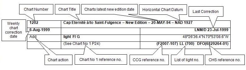
The last correction number is identified with the LNM/D or Last Notice to Mariners Number / Date. This number is expressed in either old notice number format (ex.: 594/99) or in day-month-year format which is the date known as the weekly chart correction date shown in the above diagram as item (8).
MONTHLY EDITION OF NOTICES TO MARINERS
WEB ACCESS
We are offering a feature where subscribers to our on-line service are able to receive the complete electronic monthly edition of
our Notices to Mariners. We are encouraging our clients to visit the web site to subscribe for this service:
http://www.notmar.gc.ca/subscribe/
Users wishing to receive information updates for their charts can do so by setting up a ’User Profile’ on the following web page http://www.notmar.gc.ca/search/mycharts-eng.php?czoxOToibnRtPXN0ZXBfb25lJmxhbmc9ZSI7
This feature permits users to register the nautical charts they currently have in their possession. Registrants are then automatically notified by e-mail when a Notice to Mariners is published concerning these charts.
ADVISORY
NOTICES TO SHIPPING (WRITTEN AND BROADCAST)
The Canadian Coast Guard is implementing a number of changes to the aids to navigation system in Canada.
These changes are advertised as Notices to Shipping (Broadcast and Written) by the Canadian Coast Guard and are followed up with Notices to Mariners, then charts are updated by hand correction, reprints or new editions.
Mariners are advised that all relevant Written Notices to Shipping should be kept until superseded by Notices to Mariners or through revised charts issued by the Canadian Hydrographic Service.
Written Notices to Shipping are available on the Canadian Coast Guard Website at: www.ccg-gcc.gc.ca/eng/CCG/NOTSHIP.
The Canadian Hydrographic Service is reviewing the impact of these changes with the Canadian Coast Guard and together we are preparing an action plan on the issuing of chart revisions.
For further information contact your local Regional Notices to Shipping (NOTSHIP) issuing authorities.
|
Newfoundland *Fisheries and Oceans Canada Canadian Coast Guard Port aux Basques MCTS Centre 49 Stadium Road P.O. Box 99 PORT AUX BASQUES, NL A0M 1C0 Telephone : (709) 695-2168 Facsimile : (709) 695-7784 Email :notshippax@dfo-mpo.gc.ca Website: www.ccg-gcc.gc.ca/e30407 |
Maritimes *Fisheries and Oceans Canada Canadian Coast Guard Sydney MCTS Centre 1190 Westmount Road SYDNEY, N.S, B1R 2J6 Telephone: (902) 564-7751 or 1-800-686-8676 Facsimile: (902) 564-2446 Email :notshipssyd@mar.dfo-mpo.gc.ca Website: www.ccg-gcc.gc.ca/e30406 |
|
Quèbec *Fisheries and Oceans Canada Canadian Coast Guard Les Escoumins MCTS Centre 5 Otis street, LES ESCOUMINS, QC G0T 1K0 Telephone: (418) 233-2308 Facsimile: (418) 233-3299 Email :Opsavis@dfo-mpo.gc.ca Websites :www.marinfo.gc.ca; Websites :www.marinfo.gc.ca/en/avisecrits/index.asp; Websites : http://www.ccg-gcc.gc.ca/eng/CCG/Notship-Home |
Central & Arctic *Fisheries and Oceans Canada Canadian Coast Guard Marine Communications and Traffic Services Notices to Shipping Series "C" 401 King Street West PRESCOTT, ON K0E 1T0 Telephone (613) 925-0666 or 1-800 265 0237 Facsimile: (613) 925-4519 Email :NotshipC&A@DFO-MPO.GC.CA Website: www.ccg-gcc.gc.ca/eng/CCG/Notship-Home *Fisheries and Oceans Canada Canadian Coast Guard Iqaluit MCTS Centre Notices to Shipping Series "A" and Series “H” P.O. Box 189 IQALUIT NU X0A 0H0 Telephone: (867) 979-5269 Facsimile: (867) 979-4264 Email :IQANORDREG@INNAV.GC.CA Website: www.ccg-gcc.gc.ca/eng/CCG/Notship-Home |
* Services provided in English and French
INDEX
| CANADIAN HYDROGRAPHIC SERVICE - ANNOUNCEMENT REGARDING CANADIAN HYDROGRAPHIC SERVICE CHART PATCHES | 1 |
| CANADIAN HYDROGRAPHIC SERVICE - CUMULATIVE CHART CORRECTIONS | 1 |
| CANADIAN HYDROGRAPHIC SERVICE - CURRENT CHART EDITION DATES | 1 |
| CANADIAN HYDROGRAPHIC SERVICE - PRINT ON DEMAND CHARTS - CARE AND USE | 1 |
| CANADIAN HYDROGRAPHIC SERVICE - TRANSPORT CANADA NAVIGATION SAFETY – ECDIS | 2 |
| TRANSPORT CANADA - RESTRICTED SPEED AREA - ST. CLAIR AND DETROIT RIVER. | 2 |
| CANADIAN COAST GUARD PUBLICATION - RADIO AIDS TO MARINE NAVIGATION (ATLANTIC, ST. LAWRENCE, GREAT LAKES, LAKE WINNIPEG AND EASTERN ARCTIC) PUBLICATION – 2014 - THE COMMERCIAL PUBLIC CORRESPONDENCE SERVICE | 2 |
| *301 CANADIAN HYDROGRAPHIC SERVICE - RASTER DIGITAL CHARTS (BSB V4) | 2 |
| *302 (P) LOUISBOURG HARBOUR – FOG HORN TO BE DISCONTINUED. | 3 |
| *303(T) STRAIT OF CANSO - 2016 AND 2017, REDUCED OPERATIONAL SEASON. | 3 |
| *304 MIRAMICHI RANGE DISCONTINUED. | 3 |
| *305 SOREL-TRACY À/TO OTTERBURN-PARK - NEW BUOYS ESTABLISHED. | 4 |
| *306 BAIE PIASHTI À/TO PETITE ÎLE AU MARTEAU - PRIVATE BUOYS DISCONTINUED. | 4 |
| *307 CARAQUET HARBOUR, BAIE DE SHIPPEGAN AND/ET MISCOU HARBOUR - UNLIGHTED BUOYS REPLACED. | 4 |
| *309 CANADIAN HYDROGRAPHIC SERVICE – ANNOUNCEMENT REGARDING TIDAL INFORMATION TABLES ON CHARTS. | 4 |
| NUMERICAL INDEX OF CANADIAN CHARTS AFFECTED. | |||||
| Chart No. | Page | Chart No. | Page | Chart No. | Page |
| 1350 | 4 | 4047 | 6 | 4376 | 3 |
| 1510 | 5 | 4115 | 7 | 4406 | 8 |
| 2067 | 5 | 4118 | 7 | 4429 | 8, 9 |
| 4002 | 5 | 4201 | 7 | 4432 | 9, 10 |
| 4003 | 5 | 4233 | 7 | 4456 | 4, 10 |
| 4010 | 6 | 4234 | 7 | 4617 | 10 |
| 4013 | 6 | 4243 | 7, 8 | 4912 | 3, 10 |
| 4015 | 6 | 4302 | 3 | 4913 | 4 |
| 4022 | 6 | 4321 | 8 | ||
| 4045 | 6 | 4375 | 8 | ||
SECTION 1
SAFETY AND GENERAL INFORMATION
CANADIAN HYDROGRAPHIC SERVICE - ANNOUNCEMENT REGARDING CANADIAN HYDROGRAPHIC SERVICE CHART PATCHES
Colour Web Patches are free to the mariner, and given the quality of many printers, should reproduce well. They will be available in real time all around the world.
CHS welcomes your feedback on this service at chsinfo@dfo-mpo.gc.ca.
CANADIAN HYDROGRAPHIC SERVICE - CUMULATIVE CHART CORRECTIONS
The cumulative Notices to Mariners corrections for charts can now be accessed at
www.notmar.gc.ca/search/notmar-eng.php .
CANADIAN HYDROGRAPHIC SERVICE - Current chart edition dates
CHART EDITIONS
The three terms described below are used to indicate the publication status of Canadian charts.
NEW CHART - "NEWCHT"
The first publication of a Canadian chart embracing an area not previously charted to the scale shown, or embracing an area different from any existing Canadian chart.
NEW EDITION - "NEWEDT"
A new issue of an existing chart containing amendments essential to navigation in addition to those issued in Notices to Mariners and making existing editions obsolete.
REPRINTS
A new issue of the current edition of a chart incorporating no amendments of navigational significance other than those
previously promulgated in Notices to Mariners. It may also contain amendments from other sources provided they
are not essential to navigation. Previous printings of the current edition remain in force.
The current chart edition dates can be accessed at
www.chs-shc.gc.ca/charts-cartes/paper-papier/index-eng.asp
CANADIAN HYDROGRAPHIC SERVICE - PRINT ON DEMAND CHARTS - CARE AND USE
Background
By providing nautical charts to the public, the goal of the Canadian Hydrographic Service (CHS) is to provide services for safe navigation in a fiscally responsible manner. As a result, CHS continues to expand its portfolio of nautical paper charts that are printed using Print On Demand (POD) technology. These charts are easily recognized by their whiter paper and the coloured logo of the Canadian Hydrographic Service. This new technology enables CHS to print charts in a more efficient manner while enhancing chart content through being able to quickly add new and important information. POD technology provides customers with up-to-date charts without the historical hand-drawn corrections or glued-on patches. Additionally, this technology eliminates out-of-stock situations which arise with the traditional printing and warehousing methods. In the event of a national emergency, CHS can respond to the appropriate authorities with best available information very quickly.
Care of Your POD Chart
CHS encourages its customers to handle the POD charts more carefully than the traditional lithographic charts. When plotting information on POD charts, use HB pencils and apply limited pressure. Testing has suggested that an Indian gum eraser is more effective than alternatives when used on the product. This eraser is also suitable for charts printed using lithographic processes.
CANADIAN HYDROGRAPHIC SERVICE - TRANSPORT CANADA NAVIGATION SAFETY - ECDIS
Mariners are advised that ECDIS may not display some isolated shoal depths when operating in "base or standard display" mode. Route planning and monitoring alarms for these shoal depths may not always be activated. To ensure safe navigation and to confirm that a planned route is clear of such dangers, mariners should visually inspect the planned route and any deviations from it using ECDIS configured to display "all data". The automated voyage planning check function should not be solely relied upon.
TRANSPORT CANADA - RESTRICTED SPEED AREA - ST. CLAIR AND DETROIT RIVER.
Since November 14, 2012 the restricted speed area currently in place as per the St. Clair and Detroit River Navigation Safety Regulation between the Detroit River light and Peche Island light is reduced in size by relocating the southern point of the restricted speed area from its current location at the Detroit River light to a new location at Bar Point light D33. (This notice refers to the previous one published in November 2012 with number *1103)
CANADIAN COAST GUARD PUBLICATION - RADIO AIDS TO MARINE NAVIGATION (ATLANTIC, ST. LAWRENCE, GREAT LAKES, LAKE WINNIPEG AND EASTERN ARCTIC) PUBLICATION - 2013 - The Commercial Public Correspondence Service.
Part I - Page 1 of 10
ADVANCE NOTICES
The Commercial Public Correspondence Service
Effective January 1, 2014, the following changes to the Canadian Coast Guard commercial public correspondence service, provided through select Marine Communications and Traffic Services centres, will be in effect: All long distance ship-shore calls will be administered through the regular telephone service provider as acollect call. Individuals intending to placeshore-ship calls will be required to direct-dial the appropriate MCTS centre. MCTS centres providing a commercial public correspondence service are identified in RAMN, Part 2.
*301 CANADIAN HYDROGRAPHIC SERVICE - RASTER DIGITAL CHARTS (BSB V4)
| CHARTS | MAIN TITLE | SCALE | PUBLISHED |
| New Editions | |||
| R/M1434 | Croil Islands to/à Cardinal | 1:25000 | 24-APR-2015 |
| R/M3534 | Plans - Howe Sound | 1:12000 | 27-MAR-2015 |
| R/M4002 | Golfe du Saint-Laurent / Gulf of St. Lawrence | 1:750000 | 30-OCT-2015 |
| R/M4652 | Humber Arm Meadows Point to/à Humber River | 1:14600 | 29-MAY-2015 |
| R/M4841 | Cape St Mary's to/à Argentia | 1:60000 | 29-MAY-2015 |
*302(P) LOUISBOURG HARBOUR – FOG HORN TO BE DISCONTINUED
Reference chart: 4376
The Canadian Coast Guard proposes to discontinue the following aid:
Louisbourg fog signal LL (756), (45° 54’ 24.0’’N 059° 57’ 30.5’’W). The Light and structure to remain.
Tous les navigateurs et toutes les personnes intéressées sont priées de présenter leurs observations dans les trois
mois suivant la date de publication du présent Avis, à :Comments on this action are solicited from mariners and other interested parties.
Comments should be directed to the following within three months from the date of this notice.
Superintendent,
Aids to Navigation,
Canadian Coast Guard,
PO Box 5667,
St-John’s, NL,
A1C 5X1
Telephone: 709-772-4062,
E-mail : denise.veber@dfo-mpo.gc.ca
Any objections raised must state the facts on which they are based and should include supporting information on safety, commerce and public benefit.
(G2016-012)
*303(T) STRAIT OF CANSO - 2016 AND 2017, REDUCED OPERATIONAL SEASON
Reference chart: 4302
LMariners are advised that, due to extensive maintenance requirements to the causeway swing bridge, the Canso Canal will
have a reduced operational season for the next two years. For the 2016 and 2017 navigation seasons, the Canso Canal will
operate according to the following schedule:
2016 – April 14 to October 31
2017 – May 15 to December 24
For further information, please contact:
Arden Boutilier
Officer-in-Charge
Canso Canal
Telephone: (902) 625-1973
Email: Arden.Boutilier@dfo-mpo.gc.ca
*304 MIRAMICHI - RANGE DISCONTINUED.
Reference: Notice 611(P)/15 LL (1218) and LL (1219) is now cancelled. (Chart 4912)
(G2016-003, 004)
*305 SOREL-TRACY À/TO OTTERBURN-PARK - NEW BUOYS ESTABLISHED.
Reference Chart: 1350
New unlit private information buoys:
Sorel-Tracy no1 LL (12763) orange and white color (46°01' 09".1N 073°07' 55".2W)
Sorel-Tracy no2 LL (12764) orange and white color (46°01' 12".7N 073°07' 58".8W)
Sorel-Tracy no3 LL (12765) orange and white color (46°01' 36".5N 073°07' 58".8W)
(Q2016-023, 024, 025)
*306 BAIE PIASHTI À/TO PETITE ÎLE AU MARTEAU - PRIVATE BUOYS DISCONTINUED.
Reference Chart: 4456
The following yellow spherical cautionary buoys have been discontinued:
Coin N.O..île Saint-Charles LL (11761) (50°12' 27".2N 063°18' 06".9W)
Coin N.E. île Saint-Charles LL (11762) (50°12' 24".8N 063°17' 46".8W)
Coin S.O. île Saint-Charles LL (11763) (50°12' 14".4N 063°18' 10".4W)
Coin S.E. île Saint-Charles LL (11764) (50°12' 12".1N 063°17' 50".5W)
(Q2016-006, 007, 008, 009)
*307 CARAQUET HARBOUR, BAIE DE SHIPPEGAN AND/ET MISCOU HARBOUR - UNLIGHTED BUOYS REPLACED.
Reference Chart: 4913
The following unlighted buoy have been replaced by lighted buoys:
EA31 LL (6272.26) replaced by lighted buoy EA31 LL (1272.26) Fl 4s green (47°52' 58".7N 064°31' 47".6W)
EA37 LL (6272.29) replaced by lighted buoy EA37 LL (1272.29) Fl 4s green (47°53' 15".2N 064°30' 57".6W)
(G2015-153, 154
*309 CANADIAN HYDROGRAPHIC SERVICE – ANNOUNCEMENT REGARDING TIDAL INFORMATION TABLES ON CHARTS.
Mariners are advised that the tidal levels listed in the 2016 edition of Canadian Tide and Current Tables, volumes 2 and 3 have been updated. This revision is aimed to get more precise tidal predictions in time and height. This will result in corrections to theTidal Information Table shown on charts. These corrections will be published in 2016, through Notices to Mariners.
CHART CORRECTIONS
| 1510 - Laval à/to Baie de Vaudreuil - A-B - Sheet/Feuille 2 - New Edition - 04-JUN-2010 - NAD 1983 | |||
| 04-MAR-2016 | LNM/D. 05-FEB-2016 | ||
| Add | private white and orange hazard spar buoy, Priv (See Chart No. 1, Qs) This notice affects Electronic Navigational Chart: CA479210 |
45°31′48.5″N 073°54′12.8″W | |
| (Q2016010) DFO(6409333-01) | |||
| 2067 - Hamilton Harbour - New Edition - 15-JUN-2007 - WGS84 | |||
| 18-MAR-2016 | LNM/D. 18-DEC-2015 | ||
| Add | private white and orange hazard spar buoy, marked 1 (See Chart No. 1, Qs) This notice affects Electronic Navigational Chart: CA573362 |
43°16′22.2″N 079°53′03.8″W | |
| (B2015014) DFO(6604194-01) | |||
| Add | private white and orange hazard spar buoy, marked 2 (See Chart No. 1, Qs) This notice affects Electronic Navigational Chart: CA573362 |
43°16′26.8″N 079°53′08.5″W | |
| (B2015015) DFO(6604195-01) | |||
| Add | private white and orange hazard spar buoy, marked 4 (See Chart No. 1, Qs) This notice affects Electronic Navigational Chart: CA573362 |
43°16′43.4″N 079°53′18.2″W | |
| (B2015017) DFO(6604196-01) | |||
| Add | private white and orange hazard spar buoy, marked 3 (See Chart No. 1, Qs) This notice affects Electronic Navigational Chart: CA573362 |
43°16′35.0″N 079°53′13.8″W | |
| (B2015018) DFO(6604197-01) | |||
| Delete | submerged wreck with depth over of 2.4 metres (See Chart No. 1, K22, Ka) This notice affects Electronic Navigational Chart: CA573362 |
43°16′33.6″N 079°51′12.4″W | |
| DFO(6604200-01) | |||
| Add | depth of 5.2 metres (See Chart No. 1, I10) This notice affects Electronic Navigational Chart: CA573362 |
43°16′34.0″N 079°51′13.7″W | |
| DFO(6604200-02) | |||
| 4002 - Golfe du Saint-Laurent / Gulf of St. Lawrence - New Edition - 30-OCT-2015 - NAD 1983 | |||
| 04-MAR-2016 | LNM/D. 19-FEB-2016 | ||
| Amend | Fl 15M to read Fl 13M against light (See Chart No. 1, P16) This notice affects Electronic Navigational Chart: CA179245, CA276271, CA376303 |
46°02′02.7″N 059°40′49.5″W | |
| (G2015157) LL(767) DFO(6307448-01) | |||
| 4003 - Cape Breton to/à Cape Cod - New Edition - 21-MAR-2003 - NAD 1983 | |||
| 04-MAR-2016 | LNM/D. 26-FEB-2016 | ||
| Amend | Fl 15M to read Fl 13M against light (See Chart No. 1, P16) This notice affects Electronic Navigational Chart: CA179245, CA276271, CA376303 |
46°02′20.0″N 059°40′25.0″W | |
| (G2015157) LL(767) DFO(6307448-01) | |||
| 4010 - Bay of Fundy / Baie de Fundy (Inner portion / partie intérieure) - New Edition - 14-FEB-2003 - NAD 1983 | |||
| 04-MAR-2016 | LNM/D. 15-MAY-2015 | ||
| Delete | light F (See Chart No. 1, P1) This notice affects Electronic Navigational Chart: CA276241 |
44°56′53.3″N 065°15′53.8″W | |
| (F2016003) LL(197) DFO(6307456-01) | |||
| Add | light FlR (See Chart No. 1, P1) This notice affects Electronic Navigational Chart: CA276241 |
44°56′57.7″N 065°15′55.7″W | |
| (F2016004) LL(197.3) DFO(6307456-02) | |||
| 4013 - Halifax to/à Sydney - New Edition - 06-SEP-2002 - NAD 1983 | |||
| 04-MAR-2016 | LNM/D. 12-FEB-2016 | ||
| Amend | Fl 3s 64ft 15M to read Fl 15s 64ft 13M against light (See Chart No. 1, P16) This notice affects Electronic Navigational Chart: CA179245, CA276271, CA376303 |
46°02′03.0″N 059°40′47.1″W | |
| (G2015157) LL(767) DFO(6307448-01) | |||
| 4015 - Sydney to/à Saint-Pierre - New Edition - 28-MAR-2003 - NAD 1983 | |||
| 04-MAR-2016 | LNM/D. 12-FEB-2016 | ||
| Amend | Fl 3s 64ft 15M to read Fl 15s 64ft 13M against light (See Chart No. 1, P16) This notice affects Electronic Navigational Chart: CA179245, CA276271, CA376303 |
46°02′03.0″N 059°40′47.1″W | |
| (G2015157) LL(767) DFO(6307448-01) | |||
| 4022 - Cabot Strait and approaches / Détroit de Cabot et les approches, Scatarie Island to/à Anticosti Island / Île D'Anticosti - New Edition - 17-JAN-2003 - NAD 1983 | |||
| 04-MAR-2016 | LNM/D. 12-FEB-2016 | ||
| Amend | Fl 3s 64ft 15M to read Fl 15s 64ft 13M against light (See Chart No. 1, P16) This notice affects Electronic Navigational Chart: CA179245, CA276271, CA376303 |
46°02′03.0″N 059°40′47.1″W | |
| (G2015157) LL(767) DFO(6307448-01) | |||
| 4045 - Sable Island Bank/Banc de I'Île de Sable to/au St. Pierre Bank/Banc de Saint Pierre New Edition - 10-OCT-2003 - NAD 1983 | |||
| 04-MAR-2016 | LNM/D. 05-FEB-2016 | ||
| Amend | Fl 3s 19m 15M to read Fl 15s 19m 13M against light (See Chart No. 1, P16) This notice affects Electronic Navigational Chart: CA179245, CA276271, CA376303 |
46°02′03.0″N 059°40′33.5″W | |
| (G2015157) LL(767) DFO(6307448-01) | |||
| 4047 - St. Pierre Bank/Banc de Saint-Pierre to/au Whale Bank/Banc de la Baleine New Edition - 09-OCT-1998 - NAD 1983 | |||
| 11-MAR-2016 | LNM/D. 04-DEC-2015 | ||
| Reposition | yellow ODAS/SADO lighted super-buoy Fl (5) Y, marked 44138 (See Chart No. 1, Q58) This notice affects Electronic Navigational Chart: CA276091 |
from 44°15′29.9″N 053°37′24.5″W to 44°13′00.0″N 053°36′00.0″W |
|
| (G2016008) LL(664.8) DFO(6307461-01) | |||
| 4115 - Passamaquoddy Bay and/et St. Croix River - New Edition - 24-FEB-2012 - WGS84 | |||
| 18-MAR-2016 | LNM/D. 15-AUG-2014 | ||
| Replace | wharf with wharf in ruins with legend Ru (See chart No. 1 F33.1) This notice affects Electronic Navigational Chart: CA476035 |
joining 44°59′41.3″N 066°56′46.6″W 44°59′41.3″N 066°56′42.8″W and 44°59′42.6″N 066°56′42.8″W |
|
| DFO(6307454-02) | |||
| Replace | wharf with legend Public with wharf in ruins with legend Ru (See chart No. 1 F33.1) This notice affects Electronic Navigational Chart: CA476035 |
between 44°56′48.7″N 066°58′25.0″W and 44°56′47.5″N 066°58′20.4″W |
|
| DFO(6307454-04) | |||
| 4118 - St. Marys Bay - New Edition - 13-NOV-1998 - NAD 1983 | |||
| 04-MAR-2016 | LNM/D. 22-MAY-2015 | ||
| Add | Breakwater extension (See Chart No. 1, F4.1) This notice affects Electronic Navigational Chart: CA576060 |
between 44°05′03.2″N 066°12′19.7″W and 44°05′03.5″N 066°12′15.0″W |
|
| (F2016002) DFO(6307455-02) | |||
| Reposition | light FlG (See Chart No. 1, P1) |
from 44°05′03.2″N 066°12′19.8″W to 44°05′03.5″N 066°12′15.0″W |
|
| (F2016002) LL(243.0) DFO(6307455-04) | |||
| 4201 - Halifax Harbour - Bedford Basin - New Edition - 11-AUG-2000 - NAD 1983 | |||
| 11-MAR-2016 | LNM/D. 21-NOV-2014 | ||
| Delete | orange and white mooring can buoy, marked 2 (See Chart No. 1, Q40) This notice affects Electronic Navigational Chart: CA576001 |
44°42′19.8″N 063°39′21.0″W | |
| DFO(6307462-01) | |||
| 4233 - Cape Canso to/à Country Island - Carte nouvelle - 11-JAN-1991 - NAD 1983 | |||
| 11-MAR-2016 | LNM/D. 10-OCT-2014 | ||
| Add | wreck Wk with known depth of 18 metres, 2 decimetres. (See Chart No. 1, K26) This notice affects Electronic Navigational Chart: CA376109 |
45°07′30.2″N 061°37′05.0″W | |
| DFO(6307464-01) | |||
| 4234 - Country Island to/à Barren Island - Carte nouvelle - 10-APR-1987 - NAD 1983 | |||
| 11-MAR-2016 | LNM/D. 08-JAN-2016 | ||
| Add | wreck Wk with known depth of 18 metres, 2 decimetres. (See Chart No. 1, K26) This notice affects Electronic Navigational Chart: CA376109 |
45°07′30.2″N 061°37′05.0″W | |
| DFO(6307464-01) | |||
| 4243 - Cape St. Marys - New Edition - 11-OCT-2002 - NAD 1983 | |||
| 04-MAR-2016 | LNM/D. 05-FEB-2016 | ||
| Delete | light FlG (See Chart No. 1, P1) This notice affects Electronic Navigational Chart: CA576060 |
44°05′03.1″N 066°12′20.7″W | |
| (F2016002) LL(243) DFO(6307455-01) | |||
| Add | Breakwater with loose boulders (See Chart No. 1, F4.2) This notice affects Electronic Navigational Chart: CA576060 |
joining 44°05′03.5″N 066°12′20.5″W 44°05′03.7″N 066°12′15.0″W 44°05′03.3″N 066°12′15.0″W and 44°05′03.2″N 066°12′20.3″W |
|
| (F2016002) DFO(6307455-02) | |||
| Add | light FlG (See Chart No. 1, P1) This notice affects Electronic Navigational Chart: CA576060 |
44°05′03.5″N 066°12′15.0″W | |
| (F2016002) LL(243.0) DFO(6307455-03) | |||
| Delete | depth of 2 metres, 4 decimetres (See Chart No. 1, I10) This notice affects Electronic Navigational Chart: CA576060 |
44°05′03.2″N 066°12′19.2″W | |
| DFO(6307455-10) | |||
| 4321 - Cape Canso to Liscomb Island - New Edition - 08-OCT-2004 - NAD 1983 | |||
| 11-MAR-2016 | LNM/D. 04-DEC-2015 | ||
| Add | wreck Wk with known depth of 18 metres, 2 decimetres (See Chart No. 1, K26) This notice affects Electronic Navigational Chart: CA376109 |
45°07′30.2″N 061°37′05.0″W | |
| DFO(6307464-01) | |||
| 4375 - Guyon Island to/à Flint Island - New Edition - 11-OCT-2002 - NAD 1983 | |||
| 04-MAR-2016 | LNM/D. 12-FEB-2016 | ||
| Amend | Fl 3s 64ft 15M to read Fl 15s 64ft 13M against light (See Chart No. 1, P16) This notice affects Electronic Navigational Chart: CA179245, CA276271, CA376303 |
46°02′03.0″N 059°40′33.5″W | |
| (G2015157) LL(767) DFO(6307448-01) | |||
| 4406 - Tryon Shoals to/à Cape Egmont - New Edition - 27-FEB-1998 - NAD 1983 | |||
| 11-MAR-2016 | LNM/D. 26-FEB-2016 | ||
| Delete | NOTE ″Channel Staked/Chenal marqué pa des pieux″ This notice affects Electronic Navigational Chart: CA376178 |
46°02′23.5″N 064°02′41.6″W | |
| DFO(6307463-02) | |||
| 4429 - Havre Saint-Pierre et les approches/and Approaches - New Edition - 18-FEB-2011 - NAD 1983 | |||
| 18-MAR-2016 | LNM/D. 25-DEC-2015 | ||
| Delete | marine farm limits (See Chart No. 1, K48.1) This notice affects Electronic Navigational Chart: CA379026, CA579004 |
joining 50°13′43.2″N 063°32′58.8″W 50°13′53.4″N 063°32′41.4″W 50°13′36.0″N 063°31′36.0″W 50°13′16.6″N 063°31′46.1″W 50°13′25.4″N 063°32′31.3″W and 50°13′43.2″N 063°32′58.8″W |
|
| DFO(6409304-01) | |||
| Delete | marine farm (See Chart No. 1, K48.2) |
50°13′35.0″N 063°32′15.8″W | |
| DFO(6409304-02) | |||
| Add | solid line of leading line (See Chart No. 1, M1) The usable portion of the leading line is longer than what is actually shown on the chart This notice affects Electronic Navigational Chart: CA379026, CA579004 |
between 50°14′26.5″N 063°38′47.4″W and 50°14′52.9″N 063°45′02.2″W |
|
| (Q2015187) LL(1590) DFO(6409320-01) | |||
| Delete | private yellow cautionary spar buoy, Priv (See Chart No. 1, Qm) This notice affects Electronic Navigational Chart: CA379026, CA579004 |
50°13′43.2″N 063°32′58.8″W | |
| (Q2016001) DFO(6409324-01) | |||
| Delete | private yellow cautionary spar buoy, Priv (See Chart No. 1, Qm) This notice affects Electronic Navigational Chart: CA379026, CA579004 |
50°13′53.4″N 063°32′41.4″W | |
| (Q2016002) DFO(6409325-01) | |||
| Delete | private yellow cautionary spar buoy, Priv (See Chart No. 1, Qm) This notice affects Electronic Navigational Chart: CA379026, CA579004 |
50°13′36.0″N 063°31′36.0″W | |
| (Q2016003) DFO(6409326-01) | |||
| Delete | private yellow cautionary spar buoy, Priv (See Chart No. 1, Qm) This notice affects Electronic Navigational Chart: CA379026, CA579004 |
50°13′16.6″N 063°31′46.1″W | |
| (Q2016004) DFO(6409327-01) | |||
| Delete | private yellow cautionary spar buoy, Priv (See Chart No. 1, Qm) This notice affects Electronic Navigational Chart: CA379026, CA579004 |
50°13′25.4″N 063°32′31.3″W | |
| (Q2016005) DFO(6409328-01) | |||
| 4432 - Archipel de Mingan - New Edition - 11-MAR-2011 - NAD 1983 | |||
| 18-MAR-2016 | LNM/D. 05-JUN-2015 | ||
| Delete | marine farm limits (See Chart No. 1, K48.1) This notice affects Electronic Navigational Chart: CA379026, CA579004 |
joining 50°13′43.2″N 063°32′58.8″W 50°13′53.4″N 063°32′41.4″W 50°13′36.0″N 063°31′36.0″W 50°13′16.6″N 063°31′46.1″W 50°13′25.4″N 063°32′31.3″W and 50°13′43.2″N 063°32′58.8″W |
|
| DFO(6409304-01) | |||
| Delete | marine farm (See Chart No. 1, K48.2) |
50°13′35.0″N 063°32′15.8″W | |
| DFO(6409304-02) | |||
| Add | solid line of leading line (See Chart No. 1, M1) The usable portion of the leading line is longer than what is actually shown on the chart This notice affects Electronic Navigational Chart: CA379026, CA579004 |
between 50°14′32.7″N 063°40′15.7″W and 50°14′52.9″N 063°45′02.2″W |
|
| (Q2015187) LL(1590) DFO(6409320-01) | |||
| Delete | private yellow cautionary spar buoy, Priv (See Chart No. 1, Qm) This notice affects Electronic Navigational Chart: CA379026, CA579004 |
50°13′43.2″N 063°32′58.8″W | |
| (Q2016001) DFO(6409324-01) | |||
| Delete | private yellow cautionary spar buoy, Priv (See Chart No. 1, Qm) This notice affects Electronic Navigational Chart: CA379026, CA579004 |
50°13′53.4″N 063°32′41.4″W | |
| (Q2016002) DFO(6409325-01) | |||
| Delete | private yellow cautionary spar buoy, Priv (See Chart No. 1, Qm) This notice affects Electronic Navigational Chart: CA379026, CA579004 |
50°13′36.0″N 063°31′36.0″W | |
| (Q2016003) DFO(6409326-01) | |||
| Delete | private yellow cautionary spar buoy, Priv (See Chart No. 1, Qm) This notice affects Electronic Navigational Chart: CA379026, CA579004 |
50°13′16.6″N 063°31′46.1″W | |
| (Q2016004) DFO(6409327-01) | |||
| Delete | private yellow cautionary spar buoy, Priv (See Chart No. 1, Qm) This notice affects Electronic Navigational Chart: CA379026, CA579004 |
50°13′25.4″N 063°32′31.3″W | |
| (Q2016005) DFO(6409328-01) | |||
| 4456 - Baie Piashti à/to Petite Île au Marteau - New Edition - 30-AUG-2013 - NAD 1983 | |||
| 18-MAR-2016 | |||
| Delete | marine farm (See Chart No. 1, K48.2) This notice affects Electronic Navigational Chart: CA379131 |
50°12′19.6″N 063°17′58.7″W | |
| DFO(6409300-01) | |||
| Delete | marine farm limits (See Chart No. 1, K48.1) This notice affects Electronic Navigational Chart: CA379026, CA579004 |
joining 50°13′43.2″N 063°32′58.8″W 50°13′53.4″N 063°32′41.4″W 50°13′36.0″N 063°31′36.0″W 50°13′16.6″N 063°31′46.1″W 50°13′25.4″N 063°32′31.3″W and 50°13′43.2″N 063°32′58.8″W |
|
| DFO(6409304-01) | |||
| Delete | marine farm (See Chart No. 1, K48.2) |
50°13′35.0″N 063°32′15.8″W | |
| DFO(6409304-02) | |||
| 4617 - Long Harbour, Erco Wharf - New Edition - 30-APR-2010 - NAD 1983 | |||
| 25-MAR-2016 | LNM/D. 19-JUN-2015 | ||
| Coller | patch Download Patch - http://www.chs-shc.gc.ca/patches/4617PA_20160222.pdf This notice affects Electronic Navigational Chart: CA576301 |
47°25′15.0″N 053°49′30.0″W | |
| DFO(6307490-01) | |||
| 4912 - Continuation A - New Edition - 27-JAN-2006 - NAD 1983 | |||
| 04-MAR-2016 | LNM/D. 27-NOV-2015 | ||
| Delete | front range/leading light Iso Y 13m (See Chart No. 1, P20.2) This notice affects Electronic Navigational Chart: CA476126 |
47°00′57.9″N 065°32′44.1″W | |
| (G2016003) LL(1218) DFO(6307452-01) | |||
| Delete | rear range/leading light Iso Y 4s16m, with leading line and bearings 098½° - 278½° (See Chart No. 1, P20.2, Pe) This notice affects Electronic Navigational Chart: CA476126 |
47°00′58.1″N 065°32′46.3″W | |
| (G2016004) LL(1219) DFO(6307452-02) | |||
CORRECTIONS TO RADIO AIDS TO MARINE NAVIGATION
SAILING DIRECTIONS AND SMALL CRAFT GUIDE CORRECTIONS
ATL 102 — Newfoundland — East and South Coasts, Second Edition, 2008 —
Chapter 5 — Paragraph 66, last line
Add: A submarine pipeline originating about 0.4 mile east of the outer end of the Vale wharf extends
into Long Harbour in a WSW direction for about 2.7 miles; caution is advised.
(N2016-00.5)
ATL 104 — Cape North to Cape Canso (including Bras d’Or Lake), Second Edition, 2010 —
Chapter 1 — Paragraph 102
Delete: « A light (766), … Western Point. »
Replace by: A light (766), having red and white daymarks, is shown from a skeleton tower on Western Point.
(A2016-004.2)
Chapter 1 — Paragraph 124, after “(9.1 m)”
Delete: from a white shed on Rouse Point.
Replace by: from a skeleton tower having red and white daymarks, situated on Rouse Point.
(A2016-004.3)
ATL 108 — Gulf of St. Lawrence (Southwest Portion), First Edition, 2006 —
Chapter 1 — Paragraph 42, after “overhead cables.”
Insert: A second submarine cable extends 0.25 mile from the Cape Breton Island shore,
NW of the canal entrance. A third submarine cable traverses the Strait of Canso, close NW of the causeway.
(A2016-008.4)
Chapter 2 — Delete paragraph 33 and the adjacent light pictograph.
(Q2016-012.1)
INDEX — After “Rochette, Pointe, C4/P153” (Print-on-Demand Version)
Delete: Rockhill, Pointe, C2/P33
(Q2016-012.2)
INDEX — After “Rochette, Pointe, 116”
Delete: Rockhill, Pointe, 44
(Q2016-012.2)
ATL 110 — St. Lawrence River — Cap Whittle/Cap Gaspé to Les Escoumins and Anticosti Island, Third Edition, 2011 —
Chapter 1 — Delete paragraph 123.1.
(Q2015-075.1)
Chapter 1 — Delete paragraph 140 and the adjacent caution pictograph.
(Q2016-001.1)
ATL 112 — St. Lawrence River — Cap-Rouge to Montréal and Rivière Richelieu, Third Edition, 2009 —
Chapter 2 — After paragraph 194
Insert: 194.1 Speed limit. — In Chenal du Sud, between the end of Île Grosbois and Canal Molson
(45°35'N, 73°28'W), power-driven vessels and vessels driven by electrical propulsion are subject to respect
the speed limit of 5.4 knots (10 km/h) over the ground, between the privately maintained control
buoys and the shore, as well as in La Passe, the channel known as Bras Nord —
between Île Saint-Jean and Île à Pinard — and La Grande Rivière, all of which in the vicinity of Îles de Boucherville.
(Q2016-008.1)
Chapter 2 — Adjacent to paragraph 194.1. add a caution pictograph.
(Q2016-008.2)
APPENDICES — Table of marina facilities
CHAPTER 2 : Trois-Rivières to Montréal
Make the following correction in the “Telephone” column.
| Name and location | Telephone |
| Club Nautique de Mézy Boucherville |
450-449-6487 |
(Q2016-008.3)
ATL 120 — Labrador, Camp Islands to Hamilton Inlet (including Lake Melville), First Edition, 2004 —
Chapter 2 — Paragraph 140, last line
Add: Another shoal with a least depth of 47 feet (14.3 m) is charted ESE of Dooley Ledge.
(N2016-00.6)
Chapter 2 — Paragraph 208, after “close south of it.”
Insert: A shoal with a least depth of 25 feet (7.6 m) is charted 0.4 mile north of Boulton Rock.
(N2016-00.7)
Chapter 2 — Paragraph 212
Delete: a 23-foot (7 m) reef is
Replace by: three reefs with depths of 19, 23 and 31 feet (5.8, 7 and 9.4 m) are
(N2016-00.8)
Chapter 2 — Paragraph 267
Delete: 0.5 m (2 ft)
Replace by: 1 foot (0.2 m)
(N2016-00.9)
Chapter 2 — Paragraph 329
Delete: 7 feet (2.1 m)
Replace by: 2 feet (0.6 m)
(N2016-01.0)
Chapter 2 — Paragraph 329
Delete: 12 feet (3.7 m)
Replace by: 5 feet (1.5 m)
(N2016-01.1)
CEN 301 — St. Lawrence River, Montréal to Kingston, Second Edition, 2010 —
Chapter 4 — Paragraph 96
Delete: “In 2010, … the east part.”
Replace by: In 2015, the controlling depth was 15 feet [4.6 meters] in the channel.
(C2016-004.01)
CEN 302 — Lac Ontario, First Edition, 1996 —
Chapter 2 — Paragraph 27
Delete: “In 1976, … the W end.”
Delete: “Private mooring buoys … 80 yards [73 m].”
(C2016-007.01)
Chapter 2 — Delete paragraph 29.
(C2016-007.02)
Chapter 4 — After paragraph 45
Insert: 45.1 Credit Village Marina, operated by the City of Mississauga,
has dockage with water and power. It is located in a basin on the east side of the Credit
River close downstream of the footbridge.
(C2016-006.01)
Chapter 4 — Paragraph 47
Delete: 3.7 m (12 ft), across Credit River.
Replace by: 3.6 m (11.8 ft), across Credit River. A footbridge, with a clearance of 2.3 m (7.5 ft)
spans the Credit River close downstream of the highway bridge.
(C2016-006.02)
CEN 303 — Welland Canal and Lac Érié, First Edition, 1996 —
Chapter 2 — Delete paragraph 94.1
Replace by: A dredged entrance channel leads from deep water in Niagara River through the lower entrance to Little River.
In 2015, the midchannel controlling depth was 3½ feet [1.1 m]. The upper entrance to Little River, marked by a private 344°
range, had a reported controlling depth of 4 feet [1.2 m] in 1980. Depths inside are about 4 to 7 feet [1.2 to 2.1 m].
(C2016-003.01)
Chapter 2 — Delete paragraph 132
Replace by: Buffalo has wharves in the Outer Harbor, Buffalo Ship Canal and in Buffalo River. See the Buffalo Facilities table
[of U.S. Coast Pilot 6] for a list of major wharves in Buffalo Harbor. All of the facilities have direct highway connections and
most have rail connections. Water is available at many of the piers and wharves.
(C2016-008.01)
CEN 304 — Detroit River, Lake St. Clair, St. Clair River, First Edition, 1996 —
Chapter 2 — Paragraph 23
Delete: Ted Dudley’s
Replace by: Urban Surf
(C2016-005.01)
Chapter 2 — Paragraph 29, after “ice and gasoline.”
Delete: “Shoreline Marine, on … sales and repairs.”
(C2016-005.02)
Chapter 2 — Delete paragraph 38.
(C2016-005.03)
Chapter 2 — Delete paragraph 39.
(C2016-005.04)
Chapter 2 — Paragraph 43
Delete: JR’s Sunset Grill and Marina
Replace by: Quinlan’s Family Marina
(C2016-005.05)
Chapter 2 — Delete paragraph 49 and the adjacent marina pictograph.
(C2016-005.06)
Chapter 2 — Delete paragraph 55.1.
(C2016-005.07)
Chapter 2 — Paragraph 70, after “at Chatham offered”
Delete: fuel and
(C2016-005.08)
Chapter 2 — Paragraph 77
Delete: Marine Park, a St. Clair Parkway Commission,
Replace by: Mitchell’s Bay Marine Park Limited
(C2016-005.09)
Chapter 2 — Delete paragraph 80.
(C2016-005.10)
Chapter 2 — Delete paragraph 83.
(C2016-005.11)
Chapter 2 — Delete paragraph 84.
(C2016-005.12)
INDEX — After “St. Clair Shores, Mich., C2/P95” (Print-on-Demand Version)
Delete: St. Luke, C2/P83
(C2016-005.13)
INDEX — After “St. Clair Shores, Mich., 24” Delete: St. Luke, 23
(C2016-005.13)
Small Craft Guide, Trent-Severn Waterway, Seventh Edition, 1989 —
Chapter VI — Delete paragraph 139.
(C2016-002.01)
Chapter VI — Delete paragraph 147.
(C2016-002.02)
Chapter VI — Paragraph 148
Delete: Gull Rock Marina, at Lakeview
Replace by: Golden-Medonte Powerboat Club, at Oro Station
(C2016-002.03)
Chapter VI — Delete paragraph 152.
(C2016-002.04)
Chapter VI — After paragraph 162
Insert: 162.1 Hawkestone Yacht Club a private club for members only, is located close north of the Public wharf.
The entrance is marked by privately maintained lights.
(C2016-002.05)
Chapter VI — Delete paragraph 166.
(C2016-002.06)
Chapter VII — Delete paragraph 11.
(C2016-002.07)
Chapter VII — Delete paragraph 16.
(C2016-002.08)
Chapter VII — Paragraph 18
Delete: Inner Harbour Marina
Replace by: Mariposa Landing
(C2016-002.09)
Chapter VII — Paragraph 19
Delete: Couchiching Marina
Replace by: Bridge Port (Hot Knots) Marina
(C2016-002.10)
Chapter VII — Delete paragraph 63.
(C2016-002.11)
LIST OF LIGHTS, BUOYS AND FOG SIGNALS CORRECTIONS
Newfoundland |
||||||||||
| 176.1 | Crabbes River Harbour - light buoy XD5 |
43 13 12.2 058 51 50.4 |
Fl | G | 4s | ..... | ..... | Green spar, marked "XD5". |
Seasonal. Chart:4022 Edn 03/16 (N16-001) |
|
Atlantic |
||||||||||
|
51.1 H4144 |
Richardsonville |
44 59 36.4 066 56 40.6 |
Iso | G | 4s | ..... | ..... |
Cylindrical mast, green, white and black square daymark. 6.5 |
Shoal light Year round. Radar reflector Chart:4124 Edn 03/16 (F16-009) |
|
| 54 | Bag Ledge light |
44 59 59.5 066 56 26 |
Fl | Y | 4s | 2.7 | 2 |
Cylindrical mast. Spindle with yellow tape 7 |
Operates at night only. Year round. Radar reflector. Chart:4124 Edn 03/16 (F16-008) |
|
| 197 | Delete from list
Chart:4010 Edn 03/16 (F16-003) |
|||||||||
| 197.3 | Port Lorne Breakwater | S. shore. 44 56 57.7 065 15 55.7 |
Fl | R | 4s | 3 | 2 | Aluminum pipe swing pole, red triangular daymark. 3 |
Year round.
Chart:4010 Edn 03/16 (F16-004) |
|
| 243 H3846 |
Cape St. Marys, Breakwater | On rubble breakwater. 44 05 03.5 066 12 15 |
Fl | G | 4s | 8 | 4 | Aluminum pipe swing pole. Two port hand daymarks facing 180° and 220° true |
Operates at night only. Year round. Chart: 4118 Edn 03/16 (F16-002) |
|
| 664.5 | Banquereau ODAS light buoy 44139 | 44 14 03.0 057 05 44.4 |
Fl(5) | Y | 20s | ..... | ..... | ODAS yellow light buoy. | Private. Year round. Chart:4045 Edn 03/16 (G16-005) |
|
| 664.6 | Laurentian Fan ODAS light buoy 44141 |
43 00 00 057 59 57.2 |
Fl(5) | Y | 20s | ..... | ..... | ODAS yellow light buoy. | Private. Year round. Chart:4001 Edn 03/16 (G16-006) |
|
| 664.7 | East Scotia Slope ODAS light buoy 44137 |
42 15 42 061 59 54 |
Fl(5) | Y | 20s | ..... | ..... | ODAS yellow light buoy. | Private. Year round. Chart:4003 Edn 03/16 (G16-007, 021) |
|
| 664.8 | Southwest Grand Banks ODAS light buoy 44138 |
44 13 00 053 36 00 |
Fl(5) | Y | 20s | ..... | ..... | ODAS yellow light buoy. | Private. Year round. Chart:4006 Edn 03/16 (G16-008) |
|
| 692 H3426 |
Park Point range |
| | | | | | | | |
On point, W. side of Strait. 45 32 35.8 061 19 16 |
F Fl |
Y W |
..... 4s |
12.3 13.2 |
15 ..... |
Triangular skeleton tower, white daymark, red vertical stripe. 11.0 |
Visible in line of range. Year round. White flashing locator light on site In operation 24h |
| 693 H3426.1 |
| | | | | | | | | | |
146°18’ 316.9m from front. | F Fl |
Y W |
..... 4s |
25.1 25.6 |
15 ..... |
Triangular skeleton tower, white daymark, red vertical stripe. 19.3 |
Visible in line of range. Year round. White flashing locator light on site In operation 24h. Chart:4302 Edn 03/16 (G16-023) |
|
| 766 H744 |
Main-à-Dieu | On West Point of Scatarie Island. 46 00 13.6 059 47 41 |
Fl | W | 4s | 24.7 | 7 | Skeleton tower, 3 rectangular red and white horizontal daymarks. 9.9 |
Operates at night only. Year round. Visible from all points of marine approach. Chart:4377 Edn 03/16 (G16-009) |
|
| 767 H742 |
Scatarie | NE. point of Scatarie Island. 46 02 04.3 059 40 33.7 |
Fl | W | 15s | 19.5 | 13 | Square tower, 3 rectangular daymarks horizontal red and white band. 13.9 |
Flash 1 s; eclipse 14 s. Operates at night only. Year round. Horn - Blast 2 s; sil. 3 s; blast 2 s; sil. 3 s; blast 2 s; sil. 48 s. Horn points 105°. Chart:4375 Edn 03/16 (G15-157) |
|
| 820 H802 |
MacIvers Point range |
| | | | | | | | | | | | |
On shore. 46 02 05.9 060 55 27.8 |
Iso | W | 2s | 3.6 | 10 | Square skeleton tower, white daymark, red vertical stripe. 3.6 |
Visible in line of range. Operates at night only. Seasonal. To activate the range lights, mariners can key their radio/microphone 5 pulses of 0.5 seconds each and within 10 seconds the light will be activated for 15 minutes. The lights will stay activated for 15 minutes and can be reactivated as required. Use channel 65 – 156.275 hertz. |
| 821 H802.1 |
| | | | | | | | | | | | | | |
066°23’ 33m from front. | Iso | W | 2s | 8.1 | 10 | Square skeleton tower, white daymark, red vertical stripe. 6.5 |
Visible in line of range. Operates at night only. To activate the range lights, mariners can key their radio/microphone 5 pulses of 0.5 seconds each and within 10 seconds the light will be activated for 15 minutes. The lights will stay activated for 15 minutes and can be reactivated as required. Use channel 65 – 156.275 hertz. Seasonal. Chart:4278 Edn 03/16 (G16-010, 011) |
|
| 1006 H0998 |
Nine Mile Creek, Wharf | On outer S. corner of wharf. 46 08 53 063 13 03.7 |
Fl | R | 4s | 5.4 | 5 | Square skeleton tower, red and white rectangular daymark, red triangle in center. 5.0 |
Flash 1 s; eclipse 3 s. Operates at night only. Seasonal. Chart:4466 Edn 03/16 |
|
| 1218 | Delete from list | |||||||||
| 1219 | Delete from list
Chart:4912 Edn 03/16 (G16-003, 004) |
|||||||||
| 1264.1 | Fox Dens Gully Light buoy EA30 |
Fox Dens Gully 47 52 50.8 064 31 37.1 |
Q | R | 1s | ..... | ..... | Red, marked "EA30". | Buoy may be repositioned due to shifting channel. Seasonal Chart:4913 Edn 03/16 (G16-018) |
|
| 1272.1 | Miscou Harbour Light buoy EA36 |
Fox Dens Gully 47 52 56.4 064 30 58.7 |
Q | R | 1s | ..... | ..... | Red spar, marked "EA36". | Seasonal.
Chart:4913 Edn 03/16 (G16-017) |
|
| 1272.12 | Miscou Channel Light buoy EA40 |
Fox Dens Gully 47 53 0.7 064 30 37.1 |
Q | R | 1s | ..... | ..... | Red spar, marked "EA40". | In operation 24h. Seasonal. Chart:4913 Edn 03/16 ( G16-015) |
|
| 1272.13 | Miscou Channel South cardinal Light buoy EAB |
Fox Dens Gully 47 53 05.4 064 30 31.6 |
VQ(6) + LFL |
W | 10s | ..... | ..... | Black and yellow spar marked "EAB". | In operation 24h. Seasonal. Chart:4913 Edn 03/16 (G16-020) |
|
| 1272.14 | Miscou Channel North cardinal Light buoy EAA |
Fox Dens Gully 47 53 05.3 064 30 29.8 |
Q | W | 1s | ..... | ..... | Black and yellow spar marked "EAA". | In operation 24h. Seasonal. Chart:4913 Edn 03/16 (G16-019) |
|
| 1272.26 | Miscou harbour light buoy EA31 |
Fox Dens Gully 47 52 51.4 064 31 37.4 |
Fl | G | 4s | ..... | ..... | Green spar marked "EA31". | Seasonal.
Chart:4913 Edn 03/16 (G16-013) |
|
1272.29 |
Miscou harbour Light buoy EA37 |
Fox Dens Gully 47 52 57.2 064 30 59.5 |
Fl |
G |
4s |
..... |
..... |
Green spar marked "EA37". |
In operation 24h. Seasonal. Chart:4913 Edn 03/16 (G16-014) |
|
1272.3 |
Miscou Channel Light buoy EA39 |
Fox Dens Gully 47 52 58.6 064 30 43.2 |
Q |
G |
1s |
..... |
..... |
Green, marked "EA39”. |
Seasonal. Chart:4913 Edn 03/16 (G16-016) |
|
1666.05 |
Terminal des croisières |
West end of dolphin 50 11 50.6 066 23 03.9 |
Iso |
R |
2s |
..... |
2 |
Mât. |
Operates at night only. Maintained by The Canadian Port Authority. Year round. Chart:1220 Edn 03/16 (Q15-177) |
|
| 1934 | Pointe aux Prêtres light buoy V6 |
Ile d’Orléans Chanel 47 02 59.1 070 46 59.3 |
Fl | R | 4s | ..... | ..... | Red, marked "V6". | Seasonal
Chart:1317 Edn 03/16 (Q16-013) |
|
| 2108 | Pointe des Ormes light buoy C70 |
Champlain Principal chanel 46 18 05.4 072 34 36.1 |
Fl | R | 4s | ..... | ..... | Red, marked "C70". | Winter spar. Year round. Chart:1313 Edn 03/16 (Q16-049) |
|
| 2173 | Île des Barques light buoy S123 |
46 04 48.5 073 00 53.5 |
Fl | G | 4s | ..... | ..... | Green marked "S123". | Winter spar Year round. Chart:1312 Edn 03/16 (Q16-021) |
|
|
CANADIAN COAST GUARD MARINE INFORMATION REPORT AND SUGGESTION SHEET. |
Name of Ship or Sender:..................................................................... Date:....................................
Address of Sender:..........................................................................................................................
Street # Street Name
Town / City:.............................. Prov / State:....................... Postal Code / Zip Code: ........................
Tel / Fax / E-mail address of sender (if appropriate):............................................................................
Observation Date:............................................. Time (UTC): ...........................................................
Geographical Position:......................................................................................................................
Coordinate Position: Lat: ............................................... Long:.........................................................
Position Method: q DGPS q GPS with WAAS q GPS q Radar qOther
Horizontal Datum Used: qWGS 84 q NAD 27 q Other
Estimated Position Accuracy:............................................................................................................
Chart #:............................................................ Datum: q NAD 27 q NAD 83
Chart Edition:.................................................... Last Correction applied:............................................
Publications affected: (Quote Volume and page):.................................................................................
*Full details (Attach additional sheets as necessary)............................................................................
Mariners are requested to notify the responsible authorities when new or suspected dangers to navigation are discovered, changes are observed in aids to navigation, or corrections to publications are seen to be necessary.
In the case of new or suspected dangers to navigation, it is important that all details be given in order to aid with future investigations. Items of interest include heights, depths, physical description, type of bottom and equipment method used to position the item. It is helpful to mark details on chart, which will be promptly replaced by the Canadian Hydrographic Service.
Reports should be made to the nearest Marine Communications and Traffic Services Centre (MCTS) and should be confirmed in writing to:
|
Leader, Notices to Mariners Canadian Coast Guard Department of Fisheries and Oceans Montréal, Qc H2Y 2E7 |
In the case of information concerning aids to navigation or the List of Lights, Buoys and Fog Signals. |
|
OR |
|
Dominion Hydrographer Canadian Hydrographic Service Department of Fisheries and Oceans Ottawa, Ontario, K1A 0E6 |
In the case of new or suspected dangers to navigation or where corrections to "Sailing Directions" appear to be necessary. |
Or general questions on Coast Guard programs or services please send an e-mail message to:
info@dfo-mpo.gc.ca (Please include your postal code and e-mail address).