
Archived information
The Standard on Web Usability replaces this content. This content is archived because Common Look and Feel 2.0 Standards have been rescinded.
Archived information is provided for reference, research or recordkeeping purposes. It is not subject to the Government of Canada Web Standards and has not been altered or updated since it was archived.
We appreciate your continued interest in the Monthly Edition of Notices to Mariners. As technology evolves, the Canadian Coast Guard continues to enhance its on-line service.
This is a reminder of our feature where subscribers to our on-line service are able to receive the complete electronic monthly edition of our Notices to Mariners, and would like to encourage our clients to visit the http://www.notmar.gc.ca/subscribe/ web site to subscribe to this service.
Users wishing to receive information updates for their charts can do so by setting up a "User Profile" on the web site. This feature permits users to register the nautical charts they currently have in their possession. Registrants are then automatically notified by e-mail when a Notices to Mariners is published concerning these charts.
Important
• Effective April 30th 2010 (Edition 4), the Canadian Coast Guard will discontinue the distribution of its monthly paper edition of Notices to Mariners.
• This publication will continue to be available free of charge on-line through http://www.notmar.gc.ca .
Manager, Aids to Navigation
Navigation Systems, Maritime Services
Canadian Coast Guard
|
|
Fisheries and Oceans Canada |
Pêches et Océans Canada |
VOL. 35, MONTHLY EDITION NO 03 March 26, 2010 Publication Number 40063779 |
NOTICES TO MARINERS
PUBLICATION EASTERN EDITION |
|||
Published monthly by the
CANADIAN COAST GUARD |
|||
|
|
|||
Page |
|||
| Section 1 |
Safety and General Information | 1 - 3 |
|
| Section 2 |
Chart Corrections | 4 - 14 |
|
| Section 3 |
Corrections to Radio Aids to Marine Navigation | NIL |
|
| Section 4 |
Sailing Directions and Small Craft Guide Corrections | 15 - 19 |
|
| Section 5 |
List of Lights, Buoys and Fog signals Corrections | 20 - 25 |
|
Maritime Services Directorate Aids to Navigation |
|||
EXPLANATORY NOTES |
Geographical positions refer directly to the graduations of the largest scale Canadian Hydrographic chart unless otherwise indicated. |
Bearings refer to the true compass and are measured clockwise from 000° (North) clockwise to 359°; those relating to lights are from seaward. |
Visibility of lights is that in clear weather. |
Depths - The units used for soundings (metres, fathoms or feet) are stated in the title of each chart. |
Elevations are normally given above Higher High Water, Large Tides unless otherwise indicated. |
Distances may be calculated as follows: |
1 nautical mile = 1 852 metres (6,076.1 feet) 1 statute mile = 1 609.3 metres (5,280 feet) 1 metre = 3.28 feet |
Temporary & Preliminary Notices are indicated by a (T) or a (P) before the chart action. Please note that Nautical charts are not hand amended by the Canadian Hydrographic Service for Temporary (T) and Preliminary (P) Notices. It is recommended that mariners chart these corrections in pencil. Listing of charts affected by Temporary and Preliminary Notices are revised and promulgated quarterly in Section 1 of the Monthly Edition . |
Please note that, in addition to the temporary and preliminary changes normally advertised as (T) and (P) Notices, there are a few permanent changes to navigational aids that have been advertised as Preliminary Notices to Mariners while charts are being updated for new editions. |
Marine Information Report & Suggestion Sheet - Mariners are requested to notify the responsible authorities when new or suspected dangers to navigation are discovered, changes observed in aids to navigation or corrections to publications are seen to be necessary. Such communications can be made using the Marine Information Report & Suggestion Sheet inserted on the last page of each monthly edition of Notices to Mariners. |
Monthly edition of Notices to Mariners - Notices to Mariners are issued free of charge on a monthly basis. Mariners now have a choice between specific Regional issue(s) they wish to receive. Requests to be placed on or removed from the mailing list should be made by using the form inserted on page iii of each monthly edition. Notification of changes to the mailing addresses, regional issues and/or number of copies required should also be transmitted by means of this form. |
Canadian Nautical Charts & Publications - A source list of Canadian Nautical Charts & publications is published in Notice No. 14 of the Notices to Mariners Annual Edition April 2008. The source supply and the prices effective at the time of printing are listed. For current chart edition dates refer to the following web site: http://www.chs-shc.gc.ca/pub/en/products/core.cfm |
NOTE: Cette publication est aussi disponible en français. |
CHART CORRECTIONS - SECTION 2 |
|
Corrections to nautical charts will be listed in numeric order by chart number. Each chart correction listed applies only to that particular chart. Related charts, if any, will have their own specific correction listed separately. Users should also refer to CHS Chart 1 Symbols, Abbreviations Terms for additional information pertaining to the correction of charts. The illustration below describes the elements that will comprise a typical Section 2 chart correction. |

ADVISORY |
|
NOTICES TO SHIPPING (WRITTEN AND BROADCAST) |
|
The Canadian Coast Guard is implementing a number of changes to the aids to navigation system in Canada . |
|
These changes are advertised as Notices to Shipping (Broadcast and Written) by the Canadian Coast Guard and are followed up with Notices to Mariners, then charts are updated by hand correction, reprints or new editions. |
|
Mariners are advised that all relevant Written Notices to Shipping should be kept until superseded by Notices to Mariners or through revised charts issued by the Canadian Hydrographic Service. |
|
Written Notices to Shipping are published weekly and are available from local Canadian Coast Guard Offices. |
|
The Canadian Hydrographic Service is reviewing the impact of these changes with the Canadian Coast Guard and together we are preparing an action plan on the issuing of chart revisions. |
|
For further information contact your local Regional Notices to Shipping (Notships) issuing authorities. |
|
|

|
MONTHLY EDITION OF NOTICES TO MARINERS |
WEB ACCESS |
We are offering a new feature where subscribers to our on-line service are able to receive the complete electronic monthly edition of our Notices to Mariners. We are encouraging our clients to visit the http://www.notmar.gc.ca /subscribe / web site to subscribe for this service.
Users wishing to receive information updates for their charts can do so by setting up a "User Profile" on the following web page http://www.notmar.gc.ca/search/mycharts-eng.php?czoxOToibnRtPXN0ZXBfb25lJmxhbmc9ZSI7 This feature permits users to register the nautical charts they currently have in their possession. Registrants are then automatically notified by e-mail when a Notice to Mariners is published concerning these charts. |
MAILING LIST CHANGES |
|
|
|
Please note that effective September 25, 2009 (Edition 9, 2009), only one copy of the monthly editions of Notices to Mariners publications will be sent per postal address to Canadian user. Effective April 30 th 2010 (Edition 4, 2010), the Canadian Coast Guard intends to discontinue the distribution of its monthly paper edition of Notices to Mariners to all users. This publication will continue to be available free of charge on-line through http://www.notmar.gc.ca
Until this time you may send changes to your mailing address to: Leader, Notices to Mariners Aids to Navigation Navigation Systems Canadian Coast Guard 200 Kent Street, Station 5N186 Ottawa, ON K1A 0E6 Telephone (613) 993-6974 Facsimile (613) 998-8428 Internet www.notmar.gc.ca |

INDEX |
|
CANADIAN HYDROGRAPHIC SERVICE - ANNOUNCEMENT REGARDING CANADIAN HYDROGRAPHIC SERVICE CHART PATCHES |
1 |
CANADIAN HYDROGRAPHIC SERVICE - CUMULATIVE CHART CORRECTIONS |
1 |
CANADIAN HYDROGRAPHIC SERVICE - CURRENT CHART EDITION DATES |
1 |
CANADIAN HYDROGRAPHIC SERVICE - PRINT ON DEMAND CHARTS - CARE AND USE |
1 |
*303 APPROACHES TO/APPROCHES DE HALIFAX HARBOUR - BUOY DISCONTINUED |
3 |
*302 CANADIAN COAST GUARD PUBLICATION - ANNOUNCEMENT REGARDING LORAN-C SERVICE |
2 |
*301 CANADIAN HYDROGRAPHIC SERVICE - ELECTRONIC NAVIGATIONAL CHARTS |
2 |
*304 CARAQUET HARBOUR, BAIE DE SHIPPEGAN AND/ET MISCOU HARBOUR - LIGHT DISCONTINUED |
3 |
NUMERICAL INDEX OF CANADIAN CHARTS AFFECTED |
|||||
Chart No. |
Page |
Chart No. |
Page |
Chart No. |
Page |
1234 |
4 |
4386 |
12 |
||
1235 |
4 |
4437 |
12 |
||
1236 |
5 |
4450 |
12 |
||
1310 |
5 |
4668 |
13 |
||
1313 |
5 |
4731 |
13 |
||
1432 |
5 |
L/C 4845 |
13 |
||
1433 |
5 |
4847 |
13 |
||
1510 |
5,6 |
4848 |
13 |
||
1513 |
6 |
L/C 4913 |
3,13 |
||
2293 |
6 |
4920 |
13 |
||
4015 |
6 |
6107 |
14 |
||
4020 |
7 |
8007 |
14 |
||
4022 |
7 |
||||
4099 |
8 |
||||
4115 |
8 |
||||
4124 |
8,9 |
||||
4202 |
9 |
||||
4203 |
9,10 |
||||
4211 |
10 |
||||
4237 |
3,10 |
||||
4241 |
10 |
||||
4277 |
10 |
||||
4307 |
10 |
||||
4335 |
11 |
||||
4363 |
11 |
||||
4381 |
11 |
||||
4384 |
11 |
||||
CANADIAN HYDROGRAPHIC SERVICE - ANNOUNCEMENT REGARDING CANADIAN HYDROGRAPHIC SERVICE CHART PATCHES
Colour Web Patches are free to the mariner, and given the quality of many printers, should reproduce well. They will be available in real time all around the world which is an improvement since clients had to wait for the paper copy to be mailed.
Previously, in the Notices to Mariners (NTM) booklet, Patches were produced in full colour or a minimum of black and magenta.
Due to current budgetary constraints, Patches will now only be produced in black and white for publication in the NTM booklet.
CHS welcomes your feedback on this new service at chsinfo@dfo-mpo.gc.ca
CANADIAN HYDROGRAPHIC SERVICE - CUMULATIVE CHART CORRECTIONS
The cumulative Notice to Mariners corrections for charts can now be accessed at
http://www.notmar.gc.ca/search/notmar-eng.php
CANADIAN HYDROGRAPHIC SERVICE - Current chart edition dates
CHART EDITIONS |
The three terms described below are used to indicate the publication status of Canadian charts. |
NEW CHART - "NEWCHT" |
The first publication of a Canadian chart embracing an area not previously charted to the scale shown, or embracing an area different from any existing Canadian chart. |
NEW EDITION - "NEWEDT" |
A new issue of an existing chart containing amendments essential to navigation in addition to those issued in Notice to Mariners and making existing editions obsolete. |
REPRINTS |
A new issue of the current edition of a chart incorporating no amendments of navigational significance other than those previously promulgated in Notice to Mariners. It may also contain amendments from other sources provided they are not essential to navigation. Previous printings of the current edition remain in force. |
The current chart edition dates can now be accessed at http://www.chs-shc.gc.ca/charts-cartes/paper-papier/index-eng.asp
CANADIAN HYDROGRAPHIC SERVICE - PRINT ON DEMAND CHARTS - CARE AND USE
Background By providing nautical charts to the public, the goal of the Canadian Hydrographic Service (CHS) is to provide services for safe navigation in a fiscally responsible manner. As a result, CHS continues to expand its portfolio of nautical paper charts that are printed using Print On Demand (POD) technology. These charts are easily recognized by their whiter paper and the coloured logo of the Canadian Hydrographic Service. This new technology enables CHS to print charts in a more efficient manner while enhancing chart content through being able to quickly add new and important information. POD technology provides customers with up-to-date charts without the historical hand-drawn corrections or glued-on patches. Additionally, this technology eliminates out-of-stock situations which arise with the traditional printing and warehousing methods. In the event of a national emergency, CHS can respond to the appropriate authorities with best available information very quickly. Care of Your POD Chart CHS encourages its customers to handle the POD charts more carefully than the traditional lithographic charts. When plotting information on POD charts, use HB pencils and apply limited pressure. Testing has suggested that an Indian gum eraser is more effective than alternatives when used on the product. This eraser is also suitable for charts printed using lithographic processes. |
*301 CANADIAN HYDROGRAPHIC SERVICE - Electronic Navigational Charts
RELEASED PRODUCTS |
|
S-57 ENC NUMBER |
CHART TITLE |
CA473365 |
Broughton Island and Approaches / et les Approches |
CA573366 |
Broughton Harbour and Landing Beach |
CA576054 |
Hopedale Harbour |
CA376351 |
Dog Islands to / à Cape Makkovik |
CA376352 |
Makkovik Bay (Continuation A) |
CA376356 |
Quaker Hat to / à Cape Harrison |
CA376361 |
Cape Makkovik to / à Winsor Harbour Island |
CA376362 |
Kaipokok Bay |
CA376370 |
Cape Harrison to Dog Islands |
CA476666 |
Saglek Bay |
CA576667 |
Landing Beach, Saglek Bay |
CA476682 |
Cape Kakkiviak to Duck Islands |
CA576683 |
Williams Harbour |
CA476688 |
Gray Strait and Button Islands |
CA570073 |
Vancouver Harbour, Western Portion/Partie Ouest |
CA570335 |
Broken Group (Part 1 of 2) |
CA373091 |
Lake Ontario/Lac Ontario, Western Portion/Partie ouest |
CA273097 |
Georgian Bay / Baie Georgienne |
CA373281 |
Cape Hurd to / à Lonely Island |
CA476048 |
Wedgeport and Vicinity / et les abords |
CA276138 |
Pointe Amour à / to Cape Whittle et / and Cape St. George |
CA576304 |
Port aux Basques and Approaches |
CA376819 |
Approaches to Hamilton Inlet (Northern Portion) |
CA479079 |
Baie des Ha! Ha! |
CA579084 |
Chenal du Havre de la Grande Entrée |
CA479155 |
Sorel à / to Varennes |
CA579156 |
Terminal Contrecoeur |
CA570212 |
Head of / Fond de Pipestem Inlet |
*302 CANADIAN COAST GUARD PUBLICATION - Announcement regarding Loran-C Service
On January 7, 2010, the United States Coast Guard (USCG) announced the termination of the U.S. Loran-C signal and phased decommissioning of the U.S. Loran-C infrastructure. The USCG terminated the transmissions of all US domestic Loran-C signals including those covering the Great Lakes Loran-C Chain GRI 8970 and the Northeast U.S. Loran-C Chain GRI 9960 at 2000z on February 8, 2010. All U.S. Loran-C stations are expected to cease transmitting by October 1, 2010. Other chains that are jointly operated by the U.S. and Canada will continue to be operational for the time being and possibly up to October 1, 2010. The Loran-C systems in Canada and U.S. work in tandem. Once the U.S. service is discontinued, the Canadian system will not be operational. Consequently, Canada will also decommission its Loran-C system in 2010. The official date for termination in Canada has not been set at this time, although it is expected to take place on or before October 1, 2010. Authorities in Canada and the U.S. will be collaborating on plans to discontinue Loran-C systems to minimize disruption in navigation services. Updates will be provided on CCG's Notices to Mariners website (http://www.notmar.gc.ca/go.php?doc=eng/services/notmar/Loran-C-eng), in CCG's monthly Notices to Mariners (http://www.notmar.gc.ca/) and on the CCG's website http://www.ccg-gcc.gc.ca/eng/Ccg/atn_Loran_C as further details becomes available. Comments should be directed to the Manager, Aids to Navigation, Canadian Coast Guard, 200 Kent St., 5th floor, Ottawa, ON, Canada, K1A 0E6, E-mail to Joanna.bellamy@dfo-mpo.gc.ca or by phone at (613) 998-1405 by April 20th, 2010. Any objections raised must state the facts on which they are based and should include supporting information on safety, commerce and public benefit. |
*303 Approaches to/Approches de Halifax Harbour - buoy DISCONTINUED
Reference: Notice 806(P)/2009 is now cancelled (Chart 4237) (F2010-001) |
*304 Caraquet Harbour, Baie de Shippegan and/et Miscou Harbour - light discontinued
Reference: Notice 606(P)/2008 is now cancelled (Chart L/C 4913) (G2010-002) |
CHART CORRECTIONS
1234 - Cap de la Tête au Chien à / to Cap aux Oies - New Edition - 25-MAY-2001 - NAD 1983
|
19-MAR-2010 |
LNM/D. 01-JAN-2010 |
|
|
Add |
Wk with known depth of 5 metres 7 decimetres (See Chart No. 1, K26) |
47°51'04.2"N 069°34'28.1"W |
|
DFO(6408051-01) | ||
1234 - Pointe de la Rivière du Loup - New Edition - 25-MAY-2001 - NAD 1983
|
19-MAR-2010 |
LNM/D. 01-JAN-2010 |
|||
|
Replace |
depth of 2 metres 3 decimetres with depth of 2 metres 0 decimetre (See Chart No. 1, I10) |
47°50'54.9"N 069°34'19.2"W |
||
|
DFO(6408052-02) | ||||
|
This notice might affect Electronic Navigational Chart: CA579031 | ||||
|
Add |
depth of 1 metre 9 decimetres (See Chart No. 1, I10) |
47°50'55.9"N 069°34'19.2"W | ||
|
DFO(6408052-03) | ||||
|
This notice might affect Electronic Navigational Chart: CA579031 | ||||
|
Add |
depth of 1 metre 5 decimetres (See Chart No. 1, I10) |
47°50'56.5"N 069°34'18.0"W | ||
|
DFO(6408052-04) | ||||
|
This notice might affect Electronic Navigational Chart: CA579031 | ||||
|
Add |
drying height of 2 metres 1 decimetre (See Chart No. 1, I15) |
47°50'48.2"N 069°34'08.6"W | ||
|
DFO(6408052-05) | ||||
|
This notice might affect Electronic Navigational Chart: CA579031 | ||||
|
Delete |
depth of 2 metres 8 decimetres (See Chart No. 1, I10) |
47°50'45.3"N 069°34'20.3"W | ||
|
DFO(6408052-06) | ||||
|
This notice might affect Electronic Navigational Chart: CA579031 | ||||
|
Add |
depth of 1 metre 9 decimetres (See Chart No. 1, I10) |
47°50'45.2"N 069°34'20.3"W | ||
|
DFO(6408052-07) | ||||
|
This notice might affect Electronic Navigational Chart: CA579031 | ||||
|
Delete |
depth of 5 metres 2 decimetres (See Chart No. 1, I10) |
47°50'47.1"N 069°34'26.9"W | ||
|
DFO(6408052-08) | ||||
|
This notice might affect Electronic Navigational Chart: CA579031 | ||||
|
Add |
depth of 4 metres 9 decimetres (See Chart No. 1, I10) |
47°50'47.3"N 069°34'27.9"W | ||
|
DFO(6408052-09) | ||||
|
This notice might affect Electronic Navigational Chart: CA579031 | ||||
1235 - Pointe au Boisvert à / to Cap de la Tête au Chien - New Edition - 31-MAR-2000 - NAD 1983
|
19-MAR-2010 |
LNM/D. 10-APR-2009 |
||
|
Add |
Wk with known depth of 5 metres 7 decimetres (See Chart No. 1, K26) |
47°51'04.2"N 069°34'28.1"W |
|
|
DFO(6408051-01) | |||
|
This notice might affect Electronic Navigational Chart: CA379035 | |||
1236 - Rimouski - New Edition - 23-JUL-2004 - NAD 1983
|
26-MAR-2010 |
LNM/D. 09-OCT-2009 |
|
|
Amend |
legend Iso R 1s 11m 14M to read Q R 11m 21M against light (See Chart No. 1, P10.6, P16) |
48°28'06.0"N 068°31'06.1"W |
|
(Q2009139) LL(1734) DFO(6408030-01) | ||
|
This notice might affect Electronic Navigational Chart: CA579041 | ||
|
Amend |
legend Iso R 1s 21m 14M to read Q R 21m 21M against light (See Chart No. 1, P10.6, P16) |
48°27'43.3"N 068°31'05.1"W |
|
(Q2009140) LL(1735) DFO(6408031-01) | ||
|
This notice might affect Electronic Navigational Chart: CA579041 | ||
1310 - Section B-C - Sheet 1 - New Edition - 15-FEB-2008 - NAD 1983
|
12-MAR-2010 |
LNM/D. 12-FEB-2010 |
|
|
Amend |
Iso 2s 8m 15M to read Iso 2s 10m 15M against light (See Chart No. 1, P16) |
45°35'42.3"N 073°29'34.2"W |
|
(Q2010003) LL(2363) DFO(6408038-01) | ||
|
This notice might affect Electronic Navigational Chart: CA579080 | ||
1313 - Batiscan au / to Lac Saint-Pierre - New Edition - 02-FEB-2007 - NAD 1983
|
05-MAR-2010 |
LNM/D. 05-FEB-2010 |
||
|
Delete |
Iso G 2s 33m 6M against light (See Chart No. 1, P16) |
46°24'01.1"N 072°27'16.7"W |
|
|
(Q2010009) LL(2068) DFO(6408045-01) | |||
|
This notice might affect Electronic Navigational Chart: CA479014 | |||
1432 - Lac Saint-François / Lake St. Francis B-C - Sheet 1 - New Chart - 09-JUL-1999 - NAD 1983
|
12-MAR-2010 |
LNM/D. 29-JAN-2010 |
|
|
Delete |
beacon (See Chart No. 1, Q80) |
45°02'30.9"N 074°34'13.0"W |
|
DFO(6603572-01) | ||
|
Delete |
beacon (See Chart No. 1, Q80) |
45°02'15.4"N 074°35'18.5"W |
|
DFO(6603572-02) | ||
|
Delete |
beacon (See Chart No. 1, Q80) |
45°01'50.4"N 074°36'36.7"W |
|
DFO(6603572-03) | ||
1433 - Île St-Régis to / à Croil Islands A- B - Sheet 1 - New Chart - 28-MAY-1999 - NAD 1983
|
12-MAR-2010 |
LNM/D. 16-OCT-2009 |
||
|
Delete |
beacon (See Chart No. 1, Q80) |
45°02'15.4"N 074°35'18.5"W |
|
|
DFO(6603572-02) | |||
|
Delete |
beacon (See Chart No. 1, Q80) |
45°01'50.4"N 074°36'36.7"W |
|
|
DFO(6603572-03) | |||
1510 - Lac Saint-Louis à / to Carillon - Compartment B-C - Sheet 1 - New Edition - 25-JUL-2003 - NAD 1983
|
12-MAR-2010 |
LNM/D. 14-AUG-2009 |
|
|
Delete |
red starboard hand spar buoy, marked HJ10 (See Chart No. 1, Qf) |
45°30'37.6"N 074°12'06.2"W |
|
(Q2009087) DFO(6407974-01) | ||
|
Delete |
green port hand spar buoy, marked HJ9 (See Chart No. 1, Qg) |
45°30'38.6"N 074°12'09.7"W |
|
(Q2009088) DFO(6407975-01) | ||
|
Delete |
red starboard hand spar buoy, marked HJ16 (See Chart No. 1, Qf) |
45°31'13.6"N 074°12'20.1"W |
|
|
(Q2009089) DFO(6407976-01) | |||
|
Add |
private white and orange information lighted spar buoy Fl Y (See Chart No. 1, Qp) |
45°27'28.1"N 074°05'49.8"W |
|
|
(Q2009090) DFO(6407977-01) | |||
|
Add |
private white and orange information lighted spar buoy Fl Y (See Chart No. 1, Qp) |
45°27'26.2"N 074°05'42.7"W |
|
|
(Q2009091) DFO(6407978-01) | |||
|
Add |
private white and orange information lighted spar buoy Fl Y (See Chart No. 1, Qp) |
45°27'24.6"N 074°05'38.2"W |
|
|
(Q2009092) DFO(6407979-01) | |||
|
Add |
pipeline (See Chart No. 1. L41.1) |
between 45°27'43.1"N 074°08'16.9"W | |
|
and 45°27'47.2"N 074°08'06.4"W | |||
|
DFO(6408044-01) | |||
1510 - Hudson - Sheet 1 - New Edition - 25-JUL-2003 - NAD 1983
|
12-MAR-2010 |
LNM/D. 14-AUG-2009 |
|
|
Add |
pipeline (See Chart No. 1. L41.1) |
between 45°27'43.1"N 074°08'16.9"W |
|
and 45°27'47.2"N 074°08'06.4"W |
||
|
DFO(6408044-01) | ||
1513 - River Styx to / à Kingston - Sheet 5 - New Edition - 05-JAN-2007 - NAD 1983
|
12-MAR-2010 | ||
|
Delete |
private light FG (See Chart No. 1, P1) |
44°12'54.5"N 076°25'35.5"W |
|
LL(397.1) DFO(6603573-01) | ||
2293 - Byng Inlet and Approaches / et les approches - Sheet 1 - New Edition - 30-MAR-2001 - NAD 1983
|
05-MAR-2010 |
LNM/D. 21-AUG-2009 |
||
|
Add |
rescue station (See Chart No. 1, T12) |
45°44'41.6"N 080°39'33.4"W |
|
|
DFO(6603571-01) | |||
4015 - Sydney to / à Saint-Pierre - New Edition - 28-MAR-2003 - NAD 1983
|
26-MAR-2010 |
LNM/D. 11-DEC-2009 | ||
|
Add |
maritime limit in general implying: no permanent obstructions (see Chart 1, N1.2) |
between 47°01'50.0"N 060°22'48.0"W | |
|
and 47°10'48.5"N 060°09'55.5"W | |||
|
DFO(6304706-01) | |||
|
Add |
maritime limit in general implying: no permanent obstructions (see Chart 1 N1.2) |
between 47°15'28.8"N 060°05'54.2"W | |
|
and 47°17'24.2"N 060°04'31.4"W | |||
|
DFO(6304706-02) | |||
|
Add |
See/Voir note SCIENTIFIC MOORINGS MOUILLAGES SCIENTIFIQUES |
47°07'32.0"N 060°09'00.0"W | |
|
DFO(6304706-03) | |||
|
Add |
note: SCIENTIFIC MOORINGS Acoustic sensors, one metre high and positioned approximately 800 metres apart, along the line, directly on the seabed. Mariners are advised to avoid anchoring or conducting seabed operations in the vicinity of submarine moorings. MOUILLAGES SCIENTIFIQUES Des capteurs acoustiques, d'une hauteur d'un mètre et positionnés à intervalles d'environ 800 mètres le long de la ligne, reposent directement sur le fond marin. Nous avisons les navigateurs d'éviter de mouiller ou d'effectuer des travaux sur le fond marin à proximité de ces mouillages sous-marins. |
46°04'00.0"N 060°19'00.0"W | |
|
DFO(6304706-04) | |||
4020 - Strait of Belle Isle / Détroit de Belle Isle - New Edition - 26-JUL-2002 - NAD 1983
|
12-MAR-2010 |
LNM/D. 04-SEP-2009 |
||
|
Delete |
light Fl R 3s 35ft (See Chart 1 P16) |
51°35'46.0"N 056°41'47.0"W |
|
|
(N2010010) LL(229) DFO(6304748-01) | |||
|
This notice might affect Electronic Navigational Chart: CA376094 | |||
4022 - Cabot Strait and approaches / Détroit de Cabot et les approaches, Scatarie Island to / à Anticosti Island / Île D'Anticosti - New Edition - 17-JAN-2003 - NAD 1983
|
26-MAR-2010 |
LNM/D. 08-JAN-2010 |
|
|
Add |
maritime limit in general implying: no permanent obstructions (see Chart 1, N1.2) |
between 47°01'50.0"N 060°22'48.0"W |
|
and 47°10'48.5"N 060°09'55.5"W |
||
|
DFO(6304706-01) | ||
|
This notice might affect Electronic Navigational Chart: CA276271 | ||
|
Add |
maritime limit in general implying: no permanent obstructions (see Chart 1 N1.2) |
between 47°15'28.8"N 060°05'54.2"W |
|
and 47°17'24.2"N 060°04'31.4"W |
||
|
DFO(6304706-02) | ||
|
This notice might affect Electronic Navigational Chart: CA276271 | ||
|
Add |
See/Voir note SCIENTIFIC MOORINGS MOUILLAGES SCIENTIFIQUES |
47°07'45.0"N 060°09'05.0"W |
|
DFO(6304706-03) | ||
|
This notice might affect Electronic Navigational Chart: CA276271 | ||
|
Add |
note: SCIENTIFIC MOORINGS Acoustic sensors, one metre high and positioned approximately 800 metres apart, along the line, directly on the seabed. Mariners are advised to avoid anchoring or conducting seabed operations in the vicinity of submarine moorings. MOUILLAGES SCIENTIFIQUES Des capteurs acoustiques, d'une hauteur d'un mètre et positionnés à intervalles d'environ 800 mètres le long de la ligne, reposent directement sur le fond marin. Nous avisons les navigateurs d'éviter de mouiller ou d'effectuer des travaux sur le fond marin à proximité de ces mouillages sous-marins. |
In the south margin of chart |
|
DFO(6304706-04) | ||
|
This notice might affect Electronic Navigational Chart: CA276271 | ||
4099 - Sable Island / Île de Sable, Western Portion / Partie Ouest - New Edition - 28-DEC-2001 - NAD 1983
|
05-MAR-2010 |
LNM/D. 07-AUG-2009 |
|
|
Add |
private yellow lighted spar buoy Fl(5) Y 20s (See Chart No 1 Q24) |
43°48'33.6"N 060°40'42.0"W |
|
DFO(6304700-01) | ||
|
This notice might affect Electronic Navigational Chart: CA376137 | ||
|
Add |
private yellow lighted spherical buoy Fl(5) Y 20s (See Chart No 1 Q22) |
43°48'35.4"N 060°40'31.8"W |
|
DFO(6304700-02) | ||
|
This notice might affect Electronic Navigational Chart: CA376137 | ||
4115 - Passamaquoddy Bay and / et St. Croix River - New Chart - 31-DEC-1999 - NAD 1983
|
05-MAR-2010 |
LNM/D. 07-AUG-2009 |
||
|
Add |
wharf (See Chart No 1 F14) |
between 45°02'48.3"N 066°48'32.4"W |
|
|
and 45°02'48.3"N 066°48'37.3"W |
|||
|
DFO(6304725-01) | |||
|
This notice might affect Electronic Navigational Chart: CA476035 | |||
|
Delete |
coastline (See Chart No. 1, C1) |
between 45°02'45.3"N 066°48'29.0"W |
|
|
and 45°02'49.0"N 066°48'24.0"W |
|||
|
DFO(6304725-02) | |||
|
This notice might affect Electronic Navigational Chart: CA476035 | |||
|
Add |
coastline (See Chart No. 1, C1) |
joining 45°02'45.3"N 066°48'29.2"W |
|
|
45°02'48.3"N 066°48'32.4"W |
|||
|
45°02'49.2"N 066°48'30.3"W |
|||
|
and 45°02'49.0"N 066°48'24.0"W |
|||
|
DFO(6304725-03) | |||
|
This notice might affect Electronic Navigational Chart: CA476035 | |||
|
Add |
private light FlR (Priv) (See Chart 1 P16 and P65) |
45°02'48.3"N 066°48'37.3"W |
|
|
DFO(6304725-04) | |||
|
This notice might affect Electronic Navigational Chart: CA476035 | |||
|
Delete |
ferry route (See Chart 1 M50) |
between 45°02'50.4"N 066°48'43.7"W |
|
|
and 45°02'54.7"N 066°48'32.5"W |
|||
|
DFO(6304725-06) | |||
|
This notice might affect Electronic Navigational Chart: CA476035 | |||
4124 - Letete Passage, Letang Harbour and / et Blacks Harbour - Sheet 1 - New Edition - 07-APR-2000 - NAD 1983
|
05-MAR-2010 |
LNM/D. 27-MAR-2009 |
|
|
Add |
wharf (See Chart No 1 F14) |
between 45°02'48.3"N 066°48'32.4"W |
|
and 45°02'48.3"N 066°48'37.3"W |
||
|
DFO(6304725-01) | ||
|
Delete |
coastline (See Chart No. 1, C1) |
between 45°02'45.8"N 066°48'30.0"W |
|
and 45°02'49.0"N 066°48'25.0"W |
||
|
DFO(6304725-02) | ||
|
Add |
coastline (See Chart No. 1, C1) |
joining 45°02'45.8"N 066°48'30.0"W |
|
|
||
|
Add |
coastline (See Chart No. 1, C1) |
joining 45°02'48.3"N 066°48'32.4"W |
|
45°02'49.2"N 066°48'30.3"W |
||
|
and 45°02'49.0"N 066°48'25.0"W |
||
|
DFO(6304725-03) | ||
|
Add |
private light FlR (Priv) (See Chart 1 P16 and P65) |
45°02'48.3"N 066°48'37.3"W |
|
DFO(6304725-04) | ||
|
Delete |
elevation of 14 metres (See Chart 1 K10) |
45°02'48.8"N 066°48'26.5"W |
|
DFO(6304725-05) | ||
|
Delete |
ferry route (See Chart 1 M50) |
between 45°02'50.7"N 066°48'44.0"W |
|
and 45°02'53.8"N 066°48'26.9"W |
||
|
DFO(6304725-06) | ||
|
Add |
ferry route (See Chart 1 M50) |
between 45°02'50.7"N 066°48'44.0"W |
|
and 45°02'49.6"N 066°48'36.0"W |
||
|
DFO(6304725-07) | ||
4202 - Halifax Harbour Point Pleasant to / à Bedford Basin - New Edition - 31-DEC-1999 - NAD 1983
|
05-MAR-2010 |
LNM/D. 04-DEC-2009 |
|
|
Add |
depth of 12 metres, 4 decimetres (See Chart No 1 I10) |
44°38'01.4"N 063°33'56.7"W |
|
DFO(6304701-01) | ||
|
Delete |
depth of 6 metres, 8 decimetres (See Chart No 1 I10) |
44°37'58.5"N 063°34'00.7"W |
|
DFO(6304701-02) | ||
|
Add |
depth of 5 metres, 9 decimetres (See Chart No 1 I10) |
44°37'58.4"N 063°34'00.9"W |
|
DFO(6304701-03) | ||
4202 - Ocean Terminals - New Edition - 31-DEC-1999 - NAD 1983
|
05-MAR-2010 |
LNM/D. 04-DEC-2009 |
|
|
Add |
depth of 12 metres, 4 decimetres (See Chart No 1 I10) |
44°38'01.4"N 063°33'56.7"W |
|
DFO(6304701-01) | ||
|
This notice might affect Electronic Navigational Chart: CA576004 | ||
|
Delete |
depth of 6 metres, 8 decimetres (See Chart No 1 I10) |
44°37'58.3"N 063°34'00.8"W |
|
DFO(6304701-02) | ||
|
This notice might affect Electronic Navigational Chart: CA576004 | ||
|
Add |
depth of 5 metres, 9 decimetres (See Chart No 1 I10) |
44°37'58.4"N 063°34'00.9"W |
|
DFO(6304701-03) | ||
|
This notice might affect Electronic Navigational Chart: CA576004 | ||
4203 - Halifax Harbour Black Point to / à Point Pleasant - New Edition - 14-APR-2000 - NAD 1983
|
26-MAR-2010 |
LNM/D. 23-NOV-2007 |
|
|
Add |
pipeline (See Chart No 1 L41.1) |
between 44°33'42.9"N 063°33'28.6"W |
|
|
||
|
Add |
pipeline (See Chart No 1 L41.1) |
and 44°33'44.5"N 063°33'16.5"W |
|
DFO(6304740-01) | ||
|
This notice might affect Electronic Navigational Chart: CA576002 | ||
|
Add |
depth of 20 metres over artificial feature (See Chart No. 1, Ib) |
44°33'44.5"N 063°33'16.5"W |
|
DFO(6304740-02) | ||
|
This notice might affect Electronic Navigational Chart: CA576002 | ||
4211 - Cape Lahave to / à Liverpool Bay - New Edition - 20-JUN-2003 - NAD 1983
|
05-MAR-2010 |
LNM/D. 27-NOV-2009 |
|
|
Amend |
FG to read Iso G against light (See Chart No 1 P10.3) |
44°09'29.8"N 064°28'53.3"W |
|
(F2010004) LL(417.5) DFO(6304737-01) | ||
4237 - Approaches to / Approches de Halifax Harbour - New Edition - 02-JUN-2000 - NAD 1983
|
12-MAR-2010 |
LNM/D. 15-JAN-2010 |
|
|
Delete |
green port hand lighted pillar buoy QG, marked HG1 (See Chart 1 Qg) |
44°35'11.5"N 063°27'37.0"W |
|
(F2010001) LL(544.5) DFO(6304743-01) | ||
|
This notice might affect Electronic Navigational Chart: CA476009 | ||
|
Amend |
HP2 to read HP2/2 against buoy (See Chart No 1 Qf) |
44°35'11.2"N 063°28'47.3"W |
|
(F2010002) LL(544) DFO(6304744-01) | ||
|
This notice might affect Electronic Navigational Chart: CA476009 | ||
|
Add |
red starboard hand lighted pillar bell buoy QR, marked HP2 (See Chart 1 Qf) |
44°34'29.6"N 063°27'47.2"W |
|
(F2010003T) LL(544.02) DFO(6304745-01) | ||
|
This notice might affect Electronic Navigational Chart: CA476009 | ||
4241 - Lockeport to / à Cape Sable - New Edition - 08-NOV-2002 - NAD 1983
|
05-MAR-2010 |
LNM/D. 07-AUG-2009 |
|
|
Amend |
FG to read LFlG against light (See Chart No 1 P16) |
43°29'58.0"N 065°28'14.2"W |
|
(F2009076) LL(344) DFO(6304717-01) | ||
|
This notice might affect Electronic Navigational Chart: CA376047 | ||
4277 - Entrance to / Entrée à Great Bras D'Or - New Edition - 17-APR-1998 - NAD 1983
|
05-MAR-2010 |
LNM/D. 18-SEP-2009 |
|
|
Delete |
starboard hand daybeacon, marked W R (See Chart 1 Q80) |
46°17'39.0"N 060°25'00.0"W |
|
(G2010001) DFO(6304741-01) | ||
|
This notice might affect Electronic Navigational Chart: CA576064 | ||
4307 - Canso Harbour to / au Strait of Canso - New Edition - 04-JAN-2008 - NAD 1983
|
19-MAR-2010 |
LNM/D. 13-FEB-2009 |
||
|
Delete |
wreck swept by wire drag to a depth of 2 fathoms, 3 feet (See Chart No. 1, K27) |
45°19'52.0"N 060°57'58.0"W |
|
|
DFO(6304747-01) | |||
|
This notice might affect Electronic Navigational Chart: CA476277 | |||
|
Add |
depth of 8 fathoms, 2 feet (See Chart No. 1, I10) |
45°19'52.2"N 060°57'58.5"W |
|
|
DFO(6304747-02) | |||
|
This notice might affect Electronic Navigational Chart: CA476277 | |||
4335 - Strait of Canso and Approaches / et les approaches - New Edition - 04-JAN-2008 - NAD 1983
|
05-MAR-2010 |
LNM/D. 14-AUG-2009 |
|
|
Amend |
vertical clearance of 100 feet, to read 79 feet (See Chart No. 1, D20) |
45°40'13.0"N 060°51'27.0"W |
|
DFO(6304746-01) | ||
|
19-MAR-2010 |
LNM/D. 05-MAR-2010 |
|
|
Delete |
wreck swept by wire drag to a depth of 2 fathoms, 3 feet (See Chart No. 1, K27) |
45°19'53.0"N 060°57'58.0"W |
|
DFO(6304747-01) | ||
4363 - Cape Smokey to / à St. Paul Island - New Edition - 12-SEP-2003 - NAD 1983
|
26-MAR-2010 |
LNM/D. 21-AUG-2009 |
|
|
Add |
maritime limit in general implying: no permanent obstructions (see Chart 1, N1.2) |
between 47°01'50.0"N 060°22'48.0"W |
|
and 47°10'48.5"N 060°09'55.5"W |
||
|
DFO(6304706-01) | ||
|
This notice might affect Electronic Navigational Chart: CA376167 | ||
|
Add |
See/Voir note SCIENTIFIC MOORINGS MOUILLAGES SCIENTIFIQUES |
47°08'36.0"N 060°11'51.0"W |
|
DFO(6304706-03) | ||
|
This notice might affect Electronic Navigational Chart: CA376167 | ||
|
Add |
note: SCIENTIFIC MOORINGS Acoustic sensors, one metre high and positioned approximately 800 metres apart, along the line, directly on the seabed. Mariners are advised to avoid anchoring or conducting seabed operations in the vicinity of submarine moorings. MOUILLAGES SCIENTIFIQUES Des capteurs acoustiques, d'une hauteur d'un mètre et positionnés à intervalles d'environ 800 mètres le long de la ligne, reposent directement sur le fond marin. Nous avisons les navigateurs d'éviter de mouiller ou d'effectuer des travaux sur le fond marin à proximité de ces mouillages sous-marins. |
46°38'16.0"N 060°30'37.0"W |
|
DFO(6304706-04) | ||
|
This notice might affect Electronic Navigational Chart: CA376167 | ||
4381 - Mahone Bay - New Edition - 31-JAN-2003 - NAD 1983
|
05-MAR-2010 |
LNM/D. 26-FEB-2010 |
|
|
Amend |
FG to read LFlG against light (See Chart 1 P10.5) |
44°31'21.5"N 064°18'16.1"W |
|
(F2009077) LL(454.5) DFO(6304718-01) | ||
4384 - Pearl Island to / à Cape La Have - New Edition - 10-JAN-2003 - NAD 1983
|
05-MAR-2010 |
LNM/D. 01-MAY-2009 |
|
|
Amend |
FG (Occas) FogSig to read Iso G FogSig against light (See Chart No 1 P10.3) |
44°09'32.0"N 064°28'51.0"W |
|
(F2010004) LL(417.5) DFO(6304737-01) | ||
|
This notice might affect Electronic Navigational Chart: CA476664 | ||
4386 - St.Margaret's Bay - New Edition - 16-JUL-2004 - NAD 1983
|
05-MAR-2010 |
LNM/D. 06-NOV-2009 |
|
|
Amend |
FR to read FlG against light (See Chart 1 P16) |
44°37'16.1"N 064°03'14.6"W |
|
(F2009079) LL(478) DFO(6304720-01) | ||
|
This notice might affect Electronic Navigational Chart: CA476195 | ||
4386 - Hubbards Cove - New Edition - 16-JUL-2004 - NAD 1983
|
05-MAR-2010 |
LNM/D. 06-NOV-2009 |
|
|
Amend |
FR to read FlG against light (See Chart 1 P16) |
44°37'16.1"N 064°03'14.6"W |
|
(F2009079) LL(478) DFO(6304720-01) | ||
|
This notice might affect Electronic Navigational Chart: CA476197 | ||
4437 - Pictou Harbour - New Edition - 14-MAR-2003 - NAD 1983
|
12-MAR-2010 |
LNM/D. 09-OCT-2009 |
|
|
Delete |
depth of 25 feet (See Chart No. 1, I10) |
45°40'39.5"N 062°41'50.3"W |
|
DFO(6304749-01) | ||
|
Delete |
depth of 26 feet (See Chart No. 1, I10) |
45°40'40.1"N 062°41'45.3"W |
|
DFO(6304749-02) | ||
|
Add |
depth of 21 feet (See Chart No. 1, I10) |
45°40'40.6"N 062°41'51.5"W |
|
DFO(6304749-03) | ||
|
Add |
depth of 23 feet (See Chart No. 1, I10) |
45°40'40.3"N 062°41'45.9"W |
|
DFO(6304749-04) | ||
4450 - St. Paul Island - New Edition - 21-MAR-2003 - NAD 1983
|
26-MAR-2010 | |||
|
Add |
maritime limit in general implying: no permanent obstructions (see Chart 1, N1.2) |
between 47°09'50.4"N 060°11'19.0"W | |
|
and 47°10'48.5"N 060°09'55.5"W | |||
|
DFO(6304706-01) | |||
|
Add |
See/Voir note SCIENTIFIC MOORINGS MOUILLAGES SCIENTIFIQUES |
47°10'20.0"N 060°11'05.0"W | |
|
DFO(6304706-03) | |||
|
Add |
note: SCIENTIFIC MOORINGS Acoustic sensors, one metre high and positioned approximately 800 metres apart, along the line, directly on the seabed. Mariners are advised to avoid anchoring or conducting seabed operations in the vicinity of submarine moorings. MOUILLAGES SCIENTIFIQUES Des capteurs acoustiques, d'une hauteur d'un mètre et positionnés à intervalles d'environ 800 mètres le long de la ligne, reposent directement sur le fond marin. Nous avisons les navigateurs d'éviter de mouiller ou d'effectuer des travaux sur le fond marin à proximité de ces mouillages sous-marins. |
47°14'16.9"N 060°13'25.5"W | |
|
DFO(6304706-04) | |||
4668 - Pinware Bay - Sheet 1 - New Edition - 04-JUL-2003 - NAD 1983
|
12-MAR-2010 |
LNM/D. 27-MAR-2009 |
|
|
Delete |
light Fl R 3s 35ft (See Chart 1 P16) |
51°35'43.0"N 056°42'04.0"W |
|
(N2010010) LL(229) DFO(6304748-01) | ||
4731 - Forteau Bay to / à Domino Run - New Edition - 13-JUN-2003 - Unknown
|
12-MAR-2010 |
LNM/D. 04-SEP-2009 |
||
|
Delete |
light Fl R 3s 35ft (See Chart 1 P16) |
51°35'43.0"N 056°42'10.0"W |
|
|
(N2010010) LL(229) DFO(6304748-01) | |||
L/C4845 - Renews Harbour to / à Motion Bay - New Edition - 12-SEP-1997 - NAD 1983
|
05-MAR-2010 |
LNM/D. 26-FEB-2010 |
|
|
Replace |
wharf with submerged ruins with legend Ru (See Chart No 1 F33.1) |
joining 47°01'23.4"N 052°52'57.9"W |
|
47°01'24.6"N 052°52'56.9"W |
||
|
and 47°01'26.1"N 052°52'58.1"W |
||
|
DFO(6304734-01) | ||
L/C4845 - Aquaforte Harbour - New Edition - 12-SEP-1997 - NAD 1983
|
05-MAR-2010 |
LNM/D. 26-FEB-2010 |
|
|
Replace |
wharf with submerged ruins with legend Ru (See Chart 1 F33.1) |
joining 47°01'24.1"N 052°52'57.3"W |
|
47°01'25.2"N 052°52'56.6"W |
||
|
and 47°01'26.2"N 052°52'58.0"W |
||
|
DFO(6304734-01) | ||
|
This notice might affect Electronic Navigational Chart: CA476074 | ||
4847 - Conception Bay - New Edition - 03-AUG-2001 - NAD 1983
|
05-MAR-2010 |
LNM/D. 28-AUG-2009 |
|
|
Add |
private yellow lighted spherical buoy Fl(5) Y 20s (See Chart No 1 Q22) |
47°23'28.0"N 053°07'57.0"W |
|
DFO(6304703-01) | ||
|
This notice might affect Electronic Navigational Chart: CA376120 | ||
4848 - Holyrood - Sheet 1 - New Edition - 25-JUL-2008 - NAD 1983
|
05-MAR-2010 |
LNM/D. 27-MAR-2009 |
||
|
Add |
private yellow lighted spherical buoy Fl(5) Y 20s (See Chart No 1 Q22) |
47°23'28.0"N 053°07'57.0"W |
|
|
DFO(6304703-01) | |||
|
This notice might affect Electronic Navigational Chart: CA576115 | |||
L/C4913 - Caraquet Harbour, Baie de Shippegan and / et Miscou Harbour - New Chart - 07-AUG-1992 - NAD 1983
|
05-MAR-2010 |
LNM/D. 21-AUG-2009 |
|
|
Delete |
light Iso G (See Chart 1 P1) |
47°43'22.8"N 064°40'06.0"W |
|
(G2010002) LL(1250.6) DFO(6304738-01) | ||
4920 - Shippegan Harbour - Sheet 1 - New Edition - 29-JUL-2005 - NAD 1983
|
05-MAR-2010 |
LNM/D. 23-FEB-2007 |
||
|
Add |
yellow cautionary lighted can buoy Fl Y, marked TJA (See Chart 1 Qm) |
47°43'23.5"N 064°40'05.8"W |
|
|
(G2010003) LL(1250.7) DFO(6304739-01) | |||
6107 - Hostess Island to / à Devils Cascade - Sheet 1 - New Edition - 29-OCT-1999 - NAD 1983
|
05-MAR-2010 |
LNM/D. 21-MAR-2008 |
||
|
Delete |
red starboard hand spar buoy, marked AP2 (See Chart No. 1, Qf) |
48°47'50.3"N 093°13'18.0"W |
|
|
(D2010002) DFO(6603570-01) | |||
8007 - Halifax to/à Sable Island / Île de Sable, Including/y compris Emerald Bank / Banc d'Émeraude and / et Sable Island Bank / Banc de l'Île de Sable - New Edition - 30-AUG-2002 - NAD 1983
|
05-MAR-2010 |
LNM/D. 12-FEB-2010 |
|
|
Add |
private yellow lighted spar buoy Fl(5) Y 20s (See Chart No 1 Q24) |
43°48'33.6"N 060°40'42.0"W |
|
DFO(6304700-01) | ||
|
Add |
private yellow lighted spherical buoy Fl(5) Y 20s (See Chart No 1 Q22) |
43°48'35.4"N 060°40'31.8"W |
|
DFO(6304700-02) | ||
SAILING DIRECTIONS AND SMALL CRAFT GUIDE CORRECTIONS
Arctic Canada , Volume 3, Fifth Edition, 1994 -
Chapter II - Delete paragraphs 202 and 202.1
Replace by: 202 The Croker River North Warning System (NWS) site is 2 miles inland, SE of the Croker River Delta. A radome, with an aircraft warning light on top, on a tower at the site is conspicuous.
202.1 Caution. - The Croker River site is not manned. There is an emergency shelter with a telephone and a motion-activated camera but no supplies or services.
202.2 A red building (69°17'36?N, 119°10'36?W) is on the beach near the NWS site.
(C2010-011.01)
Chapter II - Paragraph 228, lines 1 and 2
Delete: "A meteorological table" to end of paragraph.
Replace by: For weather conditions at Sachs Harbour, see Chapter 4 of Sailing Directions booklet ARC 400 - General Information, Northern Canada and visit: http://www.weatheroffice.gc.ca/canada_e.html.
(C2010-011.02)
Chapter II - Paragraph 240, line 19 - under heading "Customs"
Delete: Arctic Canada, Volume 1
Replace by: "Regulations" section in Chapter 1 of Sailing Directions booklet ARC 400 - General Information, Northern Canada and visit: http://www.cbsa-asfc.gc.ca/.
(C2010-011.03)
Chapter II - After paragraph 314
Delete: Holman and Approaches
Replace by: Ulukhaktok (Holman) and Approaches
(C2010-011.04)
Chapter II - Paragraph 315, line 1
Delete: Holman
Replace by: Ulukhaktok (Holman)
(C2010-011.05)
Chapter II - Paragraph 318, lines 1 and 2
Delete: "A meteorological table" to end of paragraph.
Replace by: For weather conditions at Ulukhaktok, see Chapter 4 of Sailing Directions booklet ARC 400 - General Information, Northern Canada and visit: http://www.weatheroffice.gc.ca/canada_e.html.
(C2010-012.01)
Chapter II - Paragraph 321, line 5
Chapter II - Paragraph 327, line 3
Chapter II - Paragraph 332, line 1
Delete: Holman
Replace by: Ulukhaktok
(C2010-012.02)
Chapter II - Paragraph 328, line 1
Delete: Holman hamlet
Replace by: Ulukhaktok hamlet
(C2010-012.03)
Chapter II - Paragraph 329, last line
Add: In 2006, the name Holman was officially changed to the traditional name of Ulukhaktok.
(C2010-012.04)
Chapter II - Paragraph 330, line 20 - under heading "Customs"
Delete: Arctic Canada, Volume 1
Replace by: "Regulations" section in Chapter 1 of Sailing Directions booklet ARC 400 - General Information, Northern Canada and visit: http://www.cbsa-asfc.gc.ca/.
(C2010-012.05)
Chapter III - Paragraph 6, line 2
Delete: Canadian Notices to Mariners
Replace by: Radio Aids to Marine Navigation, available at: http://www.ccg-gcc.gc.ca/eng/CCG/MCTS_Radio_Aids.
(C2010-013.01)
Chapter III - Paragraph 28, lines 1 and 2
Delete: "A meteorological table" to end of paragraph.
Replace by: See Chapter 4 of Sailing Directions booklet ARC 400 - General Information, Northern Canada. The DEW Line station at Cape Young was closed in 1993. For climate normals and averages, for Cape Young up to 1990, visit: http://www.climate.weatheroffice.gc.caand for maps relating to general Arctic weather patterns, visit: http://atlas.nrcan.gc.ca/site/index.html.
(C2010-013.02)
Chapter III - Paragraph 72, lines 5 and 6
Delete: "are mid-way between" to end of paragraph.
Replace by: are 1.5 miles WNW of North Star Point.
(C2010-013.03)
Chapter III - Delete paragraph 72.1, promulgated in Biweekly Edition No. 12/1994.
Replace by: 72.1 The Bernard Harbour North Warning System (NWS) site is 2.2 miles inland, WSW of Bernard Harbour. A radome, with an aircraft warning light on top, on a tower at the site is conspicuous.
72.2 Caution. - The NWS site is not manned. There is an emergency shelter with a telephone and a motion-activated camera but no supplies or services.
(C2010-013.04)
Chapter III - Delete paragraph 77.
(C2010-014.01)
Chapter III - Delete paragraph 87.
(C2010-014.02)
Chapter III - Paragraph 139, lines 1 to 7
Delete: "on the east" to end of paragraph.
Replace by: low and featureless, is the NW tip of a prominent peninsula at the south end of the east side of Dolphin and Union Strait. An abandoned airstrip, with a conspicuous aircraft hanger, and a group of smaller buildings are on the west end of the peninsula. A North Warning System site is near the small buildings.
(C2010-014.03)
Chapter III - Delete paragraphs 142 and 143.
(C2010-014.04)
Chapter III - Paragraph 166, lines 8 and 9
Delete: "A meteorological table" to end of paragraph.
Replace by: For weather conditions at Kugluktuk, see Chapter 4 of Sailing Directions booklet ARC 400 - General Information, Northern Canada and visit: http://www.weatheroffice.gc.ca/canada_e.html.
(C2010-014.05)
Chapter III - Paragraph 168, lines 6 and 8
Cancel correction promulgated in Monthly Edition No. 6/1996.
Delete: Coppermine
Replace by: Kugluktuk
(C2010-014.06)
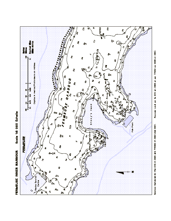
ATL 102 - Newfoundland — East and South Coasts , Second Edition, 2008 -
Chapter 3 -
Insert the FERMEUSE INNER HARBOUR Diagram with the one provided in Section 4 of this Monthly Edition.
Fermeuse Inner Harbour Diagram - http://www.notmar.gc.ca/eng/services/notmar/sec4mar10.gif or http://www.notmar.gc.ca/eng/services/notmar/sec4mar10.pdf
(N2010-00.6)
ATL 108 - Gulf of St. Lawrence (Southwest Portion), First Edition, 2006 -
Chapter 2 - In the vicinity of paragraph 93, MILLERAND diagram
Change Iso R 11m to read Iso R 2s 11m near the light @ 071°12', 515 metres from the SW corner of the border.
(Q2009-082.1)
Chapter 4 - Paragraph 203, line 1 - after "wharf"
Insert: , partially in ruins,
(Q2009-087.1)
Chapter 4 - In the vicinity of paragraph 203, GASCONS diagram
Add Ru @ 017°, 483 metres from the SW corner of the border.
(Q2009-087.2)
ATL 110 - St. Lawrence River - Cap Whittle/Cap Gaspé to Les Escoumins and Anticosti Island , Second Edition, 2002 -
Chapter 1 - Paragraph 223, lines 3 and 4
Delete: "there is ... the bay."
Replace by: there is a church spire.
(Q2010-009.1)
Chapter 2 - Paragraph 47, lines 3 and 4
Delete: "; a telecommunication ... the summit"
(Q2010-009.2)
Chapter 2 - Paragraph 81, lines 1 to 3
Delete: "A submerged ... wharf."
Replace by: A submerged dolphin and the drying remains of a wharf lie off the west end of the wharf in ruins.
(Q2009-069.1)
Chapter 2 - Paragraph 82, lines 1 to 7
Delete: "On the west ... the south."
Replace by: On the west side of the cove there is a lighted public wharf 525 feet (160 m) long. The north face of the wharf is rock-filled and the east section is in ruins. The south face provides a length of 305 feet (93 m) for berthing and a launching ramp.
(Q2010-003.1)
Chapter 2 - Delete paragraph 115
Replace by: 115 A disused lighthouse (49°05'N, 66°44'W) stands on the NE tip of the cape; it consists of a white square tower with a red upper portion.
(Q2010-009.3)
Chapter 2 - Adjacent to paragraph 115, delete the light pictograph.
(Q2010-009.4)
ATL 111 - St. Lawrence River - Île Verte to Québec and Fjord du Saguenay, Third Edition, 2007 -
Chapter 4 - Paragraph 82, lines 1 and 2
Delete: the outer end of the wharf
Replace by: a dolphin situated just SE of the wharf
(Q2009-079.1)
Chapter 4 - Paragraph 89, lines 2 and 3
Delete: "a public ... length"
Replace by: an L-shaped public wharf being used as a terminal for cruise ships. The outer end, on pilings, has a length of 656 feet (200 m) which is terminated at each end by a dolphin, connected by causeways.
(Q2009-079.2)
Chapter 4 - Paragraph 89, line 3
Delete: NW
Replace by: west
(Q2009-079.3)
ATL 112 - St. Lawrence River - Cap-Rouge to Montréal and Rivière Richelieu, Third Edition, 2009 -
Chapter 1 - Paragraph 147, lines 9 and 10
Delete: "A second light ... light structure."
(Q2010-004.1)
Chapter 2 - In the vicinity of paragraph 90, Table 2.2 Port of Sorel Wharves (Re: Correction promulgated in Monthly Edition No. 12/2009)
Make the following correction under the "Depth" column.
| Berth | Depth metres |
| Wharf No. 1 | |
14 |
7.6 |
Chapter 2 - Paragraph 236, line 7
Delete: white
(Q2010-006.1)
Chapter 2 - Paragraph 236, line 8 - after "daymarks"
Insert: with a black stripe
(Q2010-006.2)
Chapter 2 - Paragraph 237, lines 1 and 2
Delete: "The north ... shown from"
Replace by: The green lights (2379.4 and 2379.3) shown under
(Q2010-006.3)
Chapter 2 - Paragraph 237, line 4
Delete: Two fixed
Replace by: Fixed
(Q2010-006.4)
NEWFOUNDLAND |
||||||||||
229 |
St. Modeste Island |
Delete from list. Chart:4668 Edn 03/10(N10-010) |
||||||||
342 |
Leading Tickles |
49 30 21.8 55 24 25.4 |
Fl |
W |
3s |
25.3 |
6 |
Square skeleton tower, red rectangular daymark, white vertical stripe. 4.3 |
Flash 0.5s; eclipse 2.5s. Seasonal. Chart:4864 Edn 03/10 |
|
344 |
Cottrells Cove |
On westerly extremity of point. 49 28 56.5 55 18 16.4 |
Fl |
W |
4s |
16.8 |
5 |
Square skeleton tower, red rectangular daymark, white vertical stripe. 4.6 |
Seasonal. Chart:4864 Edn 03/10 |
|
344.8 |
Long Island Rock light buoy DDW.1 |
Osmonton Arm. 49 28 44.8 55 22 08.2 |
Fl |
G |
4s |
..... |
..... |
Green spar, marked "DDW.1". |
Seasonal. Chart:4864 Edn 03/10 |
|
345.3 |
Brandies Rock East Cardinal light buoy DWD |
W. of Jacob Cove. 49 31 17.8 55 21 08.4 |
VQ(3) |
W |
5s |
..... |
..... |
Black, yellow and black, marked "DWD". |
Seasonal. Chart:4864 Edn 03/10 |
|
ATLANTIC |
||||||||||
344 H3780 |
Port La Tour |
On outer end of breakwater. 43 29 58 65 28 14.2 |
LFl |
G |
6s |
6.3 |
5 |
Cylindrical mast, green and white square daymark. 3.8 |
Flash 2 s; eclipse 4 s Operates at night only. Year round. Chart:4241 Edn 03/10 (F09-076) |
|
417.5 H3718 |
Cherry Cove |
On point of land between Little Harbour and Back Cove. 44 09 29.8 64 28 53.3 |
Iso |
G |
4s |
..... |
8 |
Cylindrical mast. |
Operates at night only. Year round. Horn - Blast 3 s; sil. 27 s. Horn points 055º46'. Seasonal. Chart:4211 Edn 03/10 (F10-004) |
|
454.5 H3683 |
Western Shore Breakwater |
On seaward end of breakwater. 44 31 21.5 64 18 16.1 |
LFl |
G |
6s |
4.0 |
3 |
Square skeleton tower, green, white and black square daymark. 3.6 |
Flash 2 s; eclipse 4 s Operates at night only. Year round. Chart:4381 Edn 03/10 (F09-077) |
|
478 H3665 |
Hubbards Cove |
On Green Point, W. side of entrance. 44 37 16.1 64 03 14.6 |
Fl |
G |
6s |
..... |
6 |
Square skeleton tower, red, white and red rectangular daymark. |
Flash 1 s; eclipse 5 s Operates at night only. Year round. Chart:4386 Edn 03/10 (F09-079) |
|
544 |
Barrie Beach light and bell buoy HP2/2 |
NW. of Devils Island. 44 35 11.2 63 28 47.3 |
Fl |
R |
4s |
..... |
..... |
Red, marked "HP2/2". |
Year round. Chart:4237 Edn 03/10 (F10-002) |
|
544.5 |
Devils Island light buoy HG1 |
Delete from list. Chart:4237 Edn 03/10 (F10-001) |
||||||||
704.8 H3409 |
Arichat Head |
SW. tip of Crichton Island. 45 30 21.4 61 06 04.1 |
Fl |
W |
12s |
13.9 |
5 |
Skeleton tower, enclosed lower portion, red and white rectangular daymark. 6.7 |
Flash 2 s; eclipse 10 s. Operates at night only. Year round. Chart:4307 Edn 03/10 (G10-011) |
|
757 H3348 758 H3348.1 |
Louisbourg range |
| | | | | | | | | | |
On W. side of harbour. 45 54 05.8 59 59 23.1 267°56' 165.8m from front. |
F F |
Y Y |
..... ..... |
7.0 12.7 |
18 14 |
Triangular skeleton tower, white daymark, red vertical stripe. 4.8 Square skeleton tower, white daymark, red vertical stripe. 6.3 |
Visible in line of range. Operates at night only. Year round. Visible in line of range. Operates at night only. Year round. Chart:4376 Edn 03/10 (G10-022) |
1027.1 1027.2 |
Canoe Gully Inner range |
| | | | | | | | |
N. of Cape Egmont. 46 26 27.9 64 06 35.2 144°08' 186.7m from front. |
F F |
R R |
..... ..... |
4.6 8.3 |
5 6 |
Square skeleton tower, white daymark, red vertical stripe. 3.7 Square skeleton tower, white daymark, red vertical stripe. 4.3 |
Operates at night only. Seasonal. Operates at night only. Seasonal. Chart:4905 Edn 03/10 (G10-014) |
1250.6 |
Shippegan Gully Inner Breakwater |
Delete from list. Chart:4913 Edn 03/10 (G10-002) |
||||||||
1250.7 |
Shippegan Gully light buoy TJA |
47 43 23.5 64 40 05.8 |
Fl |
Y |
4s |
..... |
..... |
Yellow, marked "TJA". |
Seasonal. Chart:4920 Edn 03/10 (G10-003) |
|
1734 H2074 1735 H2074.1 |
Port de Rimouski range Racon -. (N) X & S Band |
| | | | | | | | | | |
S. of wharf. 48 28 06 68 31 06.1 178°23' 701.7m from front. |
Q Q |
R R |
1s 1s |
11.2 20.6 |
21 21 |
Square skeleton tower, orange daymark, black vertical stripe. 11.2 Square skeleton tower, orange daymark, black vertical stripe. 18.9 |
Visible in line of range. Emergency light. Year round. Visible in line of range. Emergency light. Year round. Chart:1236 Edn 03/10 (Q09-139, 140) |
1988 H2342 |
Sainte-Croix |
On shore. 46 37 40.8 71 43 53.8 |
Iso |
Y |
2s |
14.6 |
7 |
Skeleton tower, orange rectangular slatwork daymark. 12.6 |
Emergency mode Q G. Visible from 189° to 262°. Emergency light. Operates at night only. Year round. Chart:1314 Edn 03/10 (Q10-012) |
|
2023 H2362 2024 H2362.1 |
Pointe des Grondines range |
| | | | | | | | | | |
On point. 46 34 43.5 72 04 11.8 066°37' 2441 m from front. |
F F |
G G |
..... ..... |
14.6 38.6 |
15 15 |
Square skeleton tower, orange daymark, black vertical stripe. 8.8 Skeleton tower, orange slatwork daymark, black vertical stripe. 31.4 |
Emergency mode Q G. Visible in line of range. Year round. Emergency mode Q G. Visible in line of range. Year round. Chart:1314 Edn 03/10 (Q10-012) |
2025 H2364 2026 H2364.1 |
Pointe des Grondines Upper range |
| | | | | | | | | | |
On river bank. 46 35 06.4 72 05 52 047°15 1996.6m from front. |
F F |
G G |
..... ..... |
9.0 29.4 |
15 19 |
Skeleton tower, orange daymark, black vertical stripe. 8.0 Skeleton tower, orange slatwork daymark, black vertical stripe. 14.3 |
Emergency mode Q G. Visible in line of range. Year round. Emergency mode Q G. Visible in line of range. Year round. Chart:1314 Edn 03/10 (Q10-012) |
2050 H2370 2051 H2370.1 |
Gentilly range Racon -.- (K) X & S Band |
| | | | | | | | | | | |
On pier, Battures de Gentilly. 46 25 48 72 15 46.9 197°44' 2596.1m from front. |
F F |
G G |
..... ..... |
11.9 31.1 |
14 14 |
White tower, orange daymark, black vertical stripe. 3.7 Square skeleton tower, orange slatwork daymark, black vertical stripe. 24.3 |
Emergency mode Q G. Visible in line of range. Operates at night only. Year round. Emergency mode Q G. Visible in line of range. Operates at night only. Year round. Chart:1313 Edn 03/10 (Q10-012) |
2067 H2390 2068 H2390.1 |
Cap-de-la-Madeleine Lower range |
| | | | | | | | | | | |
On N. shore. 46 23 36.1 72 27 44.5 037°31' 975.2m from front. |
F F |
G G |
..... ..... |
18.6 33.0 |
17 17 |
Square skeleton tower, orange slatwork daymark, black vertical stripe. 9.1 Skeleton tower, orange slatwork daymark, black vertical stripe. 23.1 |
Emergency light. Visible in line of range. Year round. Visible in line of range. Emergency light. Year round. Chart:1313 Edn 03/10 (Q10-009) |
2125 H2402 2126 H2402.1 |
Pointe-du-Lac range |
| | | | | | | | | | | | | |
46 16 05.5 72 41 43.2 056°08' 2263.6m from front. |
F Iso F |
G Y G |
..... 2s ..... |
12.1 12.3 49.1 |
12 5 12 |
Orange cylindrical tower, orange lower portion, orange daymark, black vertical stripe. 5.4 White skeleton tower, orange slatwork daymark, black vertical stripe. 33.9 |
Emergency mode Q G. Visible in line of range. Radar reflector. Operates at night only. Year round. Visible 360°. Emergency mode Q G. Visible in line of range. Operates at night only. Year round. Chart:1312 Edn 03/10 (Q10-012) |
2137.2 H2405 2137.3 H2405.1 |
Yamachiche Curve West range Racon - - (M) X & S Band |
| | | | | | | | | | | | |
46 12 18.7 72 49 49.1 236°01' 761.8m from front. |
F Fl F |
G G G |
..... 6s ..... |
10.2 9.2 25.5 |
14 4 14 |
Cylindrical tower, orange rectangular daymark, black vertical stripe. 2.6 White tower, orange daymark, black vertical stripe. 17.3 |
Emergency mode Q G. Visible in line of range. Operates at night only. Year round. Flash 1 s; eclipse 5 s. Visible 360°. Operates at night only. Emergency mode Q G. Visible in line of range. Operates at night only. Year round. Chart:1312 Edn 03/10 (Q10-012) |
|
Lac St-Pierre Downstream (Curve Louiseville) range |
| | | | | | | | | | | | | | | | | |
On pier in water. 46 11 41.5 72 53 43.9 044°04' 609.8m from front. |
F Iso F Iso |
G W G G |
..... 2s ..... 2s |
11.6 12.0 21.0 21.6 |
12 6 12 4 |
Orange rectangular tower, orange rectangular daymark, black vertical stripe. 15.0 Square tower, orange daymark, black vertical stripe. 15.0 |
Emergency mode Q G. Visible in line of range. Radar reflector. Operates at night only. Year round. Visible 360°. Operates at night only. Emergency mode Q G. Visible in line of range. Operates at night only. Year round. Visible 360°. Operates at night only. Chart:1312 Edn 03/10 (Q10-012) |
2166 H2414 2167 H2414.1 |
Île aux Raisins range Racon -.- (K) X Band |
| | | | | | | | | | | | |
46 06 10.7 72 57 52.4 193° 573.9m from front. |
F F Iso |
G G W |
..... .... 2s |
9.7 26.9 26.9 |
11 11 6 |
White cylindrical tower, orange daymark, black vertical stripe. 7.0 Square tower, orange slatwork daymark, black vertical stripe. 38.9 |
Emergency mode Q G. Visible in line of range. Operates at night only. Year round. Emergency mode Q G. Visible in line of range. Operates at night only. Year round. Visible 360°. Operates at night only. Chart:1312 Edn 03/10 (Q10-012) |
2168 H2416 2169 H2416.1 |
Île des Barques range |
| | | | | | | | | | |
On E. end of island. 46 05 15.3 72 59 41.8 218°26' 480m from front. |
F F |
G G |
..... ..... |
11.4 25.2 |
13 13 |
Square tower, orange daymark, black vertical stripe. 4.0 Cylindrical tower, orange daymark, black vertical stripe. 19.7 |
Emergency mode Q G. Visible in line of range. Operates at night only. Year round. Emergency mode Q G. Visible in line of range. Operates at night only. Year round. Chart:1312 Edn 03/10 (Q10-012) |
2175 H2426 2176 H2426.1 |
Île de Grâce range |
| | | | | | | | | | | | | | | | |
On pier, N. of Île des Barques. 46 04 08.4 73 02 59.8 073°16' 598.4m from front. |
F Iso F Iso |
G G G G |
..... 2s ..... 2s |
12.8 12.8 22.1 22.1 |
15 5 15 5 |
White square tower, orange daymark, black vertical stripe. 8.2 Square tower, enclosed upper portion, orange slatwork daymark, black vertical stripe. 17.8 |
Emergency mode Q G. Visible in line of range. Operates at night only. Year round. Visible from 311° to 346° approx. Operates at night only. Emergency mode Q G. Visible in line of range. Operates at night only. Year round. Visible from 275° to 018° approx. Operates at night only. Chart:1312 Edn 03/10 (Q10-012) |
2180 H2424 2181 H2424.1 |
Île du Moine range |
| | | | | | | | | |
On a pier located on shore, S. of island. 46 03 58.3 73 01 29.7 082°33' 488.2m from front. |
F F |
G G |
..... ..... |
13.1 27.4 |
14 14 |
White square tower, orange daymark, black vertical stripe. 10.0 Skeleton tower, orange daymark, black vertical stripe. 18.6 |
Emergency mode Q G. Visible in line of range. Operates at night only. Year round. Emergency mode Q G. Visible in line of range. Operates at night only. Year round. Chart:1312 Edn 03/10 (Q10-012) |
2274 H2450 2275 H2450.1 |
Course Île Dupas range |
| | | | | | | | | |
On shore, E. side of Île aux Cochons 46 03 27.9 73 09 23 015°07' 623.3m from front. |
F F |
G G |
..... ..... |
13.9 25.4 |
12 12 |
White square tower, orange daymark, black vertical stripe. 3.9 Skeleton tower, orange slatwork daymark, black vertical stripe. 20.4 |
Emergency mode Q G. Visible in line of range. Operates at night only. Year round. Emergency mode Q G. Visible in line of range. Operates at night only. Year round. Chart:1311 Edn 03/10 (Q10-012) |
2282 H2452 2283 H2452.1 |
Route Île Saint-Ours range |
| | | | | | | | | | | |
Off shore. 45 53 05.4 73 12 57.9 182°22' 670.3m from front. |
F F F |
G G G |
..... ..... ..... |
17.1 33.0 32.7 |
13 13 6 |
Square tower, orange slatwork daymark, black vertical stripe. 13.2 Square tower, orange slatwork daymark, black vertical stripe. 18.6 |
Emergency mode only Q G. Night emergency light. Visible in line of range. Year round. Emergency mode only Q G. Night emergency light. Visible in line of range. Visible from 066°20' through E. to 112°23'. Year round. Chart:1311 Edn 03/10 (Q10-012) |
2288 H2454 2289 H2454.1 |
Petite Traverse range |
| | | | | | | | | | | |
On E. bank. 45 54 40.1 73 12 29.1 045°43' 517.2m from front. |
F F F F |
G G G G |
..... ..... ..... ..... |
16.8 16.4 31.9 31.6 |
14 6 14 6 |
Cylindrical tower, orange slatwork daymark, black vertical stripe. 7.0 Square skeleton tower, orange slatwork daymark, black vertical stripe. 20.5 |
Emergency mode only Q G. Visible in line of range. Visible from 045°30' through E. to 164°30'. Year round. Emergency mode only Q G. Visible in line of range. Visible from 360°. Year round. Chart:1311 Edn 03/10 (Q10-012) |
2312 H2470 2313 H2470.1 |
Traverse Contrecoeur range |
| | | | | | | | | |
45 49 55.5 73 16 54.2 200°10' 400.4m from front. |
F F |
G G |
..... ..... |
16.3 28.0 |
15 15 |
White cylindrical tower, orange daymark, black vertical stripe. 11.5 Square tower, orange daymark, black vertical stripe. 22.4 |
Emergency mode Q G. Visible in line of range. Year round. Emergency mode Q G. Visible in line of range. Year round. Chart:1311 Edn 03/10 (Q10-012) |
2315 H2472 2316 H2472.1 |
Contrecoeur-Verchères range |
| | | | | | | | | | | | |
On pier, Contrecoeur Islands. 45 51 54.9 73 15 06.7 040°24' 1273.6m from front. |
F F Iso |
G G G |
..... ..... 2s |
9.4 20.2 20.4 |
14 14 4 |
Square tower, orange slatwork daymark, black vertical stripe. 4.1 Square skeleton tower, orange slatwork daymark, black vertical stripe. 15.2 |
Emergency mode Q G. Visible in line of range. Operates at night only. Year round. Emergency mode Q G. Visible in line of range. Operates at night only. Year round. Visible from 360°. Operates at night only. Chart:1311 Edn 03/10 (Q10-012) |
2326 H2480 2327 H2480.1 |
Île Bouchard range |
| | | | | | | | | |
On island. 45 47 56.4 73 20 40.5 037°37' 934.4m from front. |
F F |
G G |
..... ..... |
13.3 22.1 |
14 14 |
Cylindrical mast, orange rectangular daymark, black vertical stripe. 9.1 Square tower, orange daymark, black vertical stripe. 17.6 |
Emergency mode Q G. Visible in line of range. Year round. Emergency mode Q G. Visible in line of range. Year round. Chart:1311 Edn 03/10 (Q10-012) |
2363 H2499 2364 H2499.1 |
Course Longue-Pointe range |
| | | | | | | | | | |
S. end of Grandes Battures Tailhandier. 45 35 42.3 73 29 34.2 022°38' 476.6m from front. |
Iso Iso |
W W |
2s 2s |
10.0 17.2 |
15 15 |
White cylindrical tower, orange rectangular daymark, black vertical stripe. 6.3 White cylindrical tower, orange rectangular daymark, black vertical stripe. 14.4 |
Visible in line of range. Operates at night only. Year round. Visible in line of range. Operates at night only. Year round. Chart:1310 Edn 03/10 (Q10-003) |

