
Archived information
The Standard on Web Usability replaces this content. This content is archived because Common Look and Feel 2.0 Standards have been rescinded.
Archived information is provided for reference, research or recordkeeping purposes. It is not subject to the Government of Canada Web Standards and has not been altered or updated since it was archived.
NOTICES TO MARINERS
PUBLICATION
EASTERN EDITION

Safety First, Service Always
Published Monthly by the
CANADIAN COAST GUARD
www.notmar.gc.ca/subscribe/
CONTENTS
| Section 1 | General and Safety Information |
| Section 2 | Chart Corrections |
| Section 3 | Radio Aids to Marine Navigation Corrections |
| Section 4 | Sailing Directions and Small Craft Guide Corrections |
| Section 5 | List of Lights, Buoys and Fog Signals Corrections |
Canadian Coast Guard Programs
Aids to Navigation and Waterways
Fisheries and Oceans Canada
Montreal, Quebec
H2Y 2E7
© Her Majesty the Queen in Right of Canada, 2016
DFO/2016-2002
Fs152-6E-PDF
ISSN 1719-7708
Disponible en français :
Publication des Avis aux navigateurs
Édition de l'Est
Édition mensuelle Nº10/2016
Fisheries and Oceans Canada
Official Publication of the Canadian Coast Guard
DFO/2018-2002
EXPLANATORY NOTES
Geographical positions refer directly to the graduations of the largest scale Canadian Hydrographic chart unless otherwise indicated.
Bearings refer to the true compass and are measured clockwise from 000° (North) clockwise to 359°; those relating to lights are from seaward.
Visibility of lights is that in clear weather.
Depths - The units used for soundings (metres, fathoms or feet) are stated in the title of each chart.
Elevations are normally given above Higher High Water, Large Tide unless otherwise indicated.
Distances may be calculated as follows:
1 nautical mile = 1,852 metres (6,076.1 feet)
1 statute mile = 1,609.3 metres (5,280 feet)
1 metre = 3.28 feet
Temporary & Preliminary Notices are indicated by a (T) or a (P) in Section 1, respectively. Please note that Nautical charts are not amended by the Canadian Hydrographic Service for Temporary (T) and Preliminary (P) Notices. It is recommended that mariners chart these corrections in pencil. The list of charts affected by Temporary and Preliminary Notices are revised and promulgated quarterly in Section 1 of the Monthly Edition.
Please note that, in addition to the temporary and preliminary changes normally advertised as (T) and (P) Notices, there are a few permanent changes to aids to navigation that have been advertised as Preliminary Notices to Mariners while charts are being updated for new editions.
Marine Information Report & Suggestion Sheet
Mariners are requested to notify the responsible authorities when new or suspected dangers to navigation are discovered, changes observed in aids to navigation or corrections to publications are seen
to be necessary. Such communications can be made using the Marine Information Report & Suggestion Sheet inserted on the last
page of each monthly edition of Notices to Mariners.
Canadian Hydrographic Service - Information Published in Section 2 of Notices to Mariners
Mariners are advised that only the most critical changes that directly affect safety to navigation are issued in Section 2 – Chart Corrections. This limitation
is required to ensure that charts remain as clear and easy to read as possible. As a result, mariners may see minor discrepancies of a
non-critical nature between information in official publications. For example, a small change in the nominal range or focal height of a light
may not result in the production of a chart correction in Notices to Mariners, but may result in a correction in the List of Lights, Buoys and
Fog Signals publication.
In case of discrepancy between information provided on CHS charts relating to aids to navigation, and the List of Lights, Buoys and Fog Signals publication, the latter shall be deemed as containing the most up-to-date information.
Canadian Nautical Charts & Publications
A source list of Canadian nautical charts and publications is published in Notice No. 14 of the Notices to Mariners Annual Edition 2018. The source supply and the prices
effective at the time of printing are listed. For current chart edition dates, please refer to the following website:
www.chs-shc.gc.ca/charts-cartes/paper-papier/index-eng.asp
CHART CORRECTIONS - SECTION 2
Corrections to nautical charts will be listed in numerical order by chart number. Each chart correction listed applies only to that particular chart. Related charts, if any, will have their own specific correction listed separately.
Users should also refer to CHS Chart 1: Symbols, Abbreviations and Terms for additional information pertaining to the correction of charts.
The illustration below describes the elements that will comprise a typical Section 2 chart correction:

The last correction number is identified with the LNM/D or Last Notice to Mariners Number / Date.
NOTICES TO MARINERS WEBSITE – MONTHLY EDITIONS, CHART CORRECTIONS, AND CHART PATCHES
The Notices to Mariners website allows users to access the monthly publications,
chart corrections, and chart patches.
Users can subscribe for free to the email notification service
to receive notifications when charts of interest are updated, including their patches, as well as when a new monthly edition becomes available online.
ADVISORY NOTICES TO SHIPPING (BROADCAST AND WRITTEN)
The Canadian Coast Guard is implementing a number of changes to the aids to navigation system in Canada.
These changes are advertised as Notices to Shipping (Broadcast and Written) by the Canadian Coast Guard, and are then followed up with Notices to Mariners, then charts are updated by hand correction, reprints or new editions.
Mariners are advised that all relevant Written Notices to Shipping should be kept until superseded by Notices to Mariners or through revised charts issued by the Canadian Hydrographic Service (CHS).
Written Notices to Shipping are available on the Canadian Coast Guard website at: www.ccg-gcc.gc.ca/eng/CCG/NOTSHIP.
The Canadian Hydrographic Service is reviewing the impact of these changes with the Canadian Coast Guard and together are preparing an action plan on the issuing of chart revisions.
For further information, contact your local Regional Notices to Shipping (NOTSHIP) issuing authorities.
Newfoundland
* Port aux Basques MCTS Centre
Canadian Coast Guard
49 Stadium Rd.
P.O. Box 99
Port aux Basques, NL A0M 1C0
Telephone: (709) 695-2168 or 1-800-563-9089
Facsimile: (709) 695-7784
Email: notshippax@dfo-mpo.gc.ca
Website: http://www.ccg-gcc.gc.ca/eng/CCG/Notship#nfld
Central & Arctic
* Prescott MCTS Centre
Canadian Coast Guard
401 King Street West
P.O. Box 1000
Prescott, ON K0E 1T0
“C” Series NOTSHIPs
Telephone: (613) 925-0666
Facsimile: (613) 925-4519
Email: CA.XCA-NotshipDesk@dfo-mpo.gc.ca
Website: http://www.ccg-gcc.gc.ca/eng/CCG/Notship-Home
Maritimes
* Sydney MCTS Centre
Canadian Coast Guard
1190 Westmount Road
Sydney, NS B1R 2J6
Telephone: (902) 564-7751 or 1-800-686-8676
Facsimile: (902) 564-7662
Email: notshipssyd@mar.dfo-mpo.gc.ca
Website: http://www.ccg-gcc.gc.ca/eng/CCG/Notship#maritime
Québec
* Les Escoumins MCTS Centre
Canadian Coast Guard
35, rue Otis
Les Escoumins, QC G0T 1K0
Telephone: (418) 233-2308
Facsimile: (418) 233-3299
Email: opsavis@dfo-mpo.gc.ca
Website: www.marinfo.gc.ca/en/avisecrits/index.asp
* Iqaluit MCTS Centre
Operational from approximately mid-May until late December.
Canadian Coast Guard
P.O. Box 189
Iqaluit, NU X0A 0H0
“A” Series NOTSHIPs
Telephone: (867) 979-5269
Facsimile: (867) 979-4264
Email: IqaNordreg@innav.gc.ca
Website: http://www.ccg-gcc.gc.ca/eng/CCG/Notship-Home
“H” Series NOTSHIPs
Telephone: (867) 979-0310
Facsimile: (867) 979-4264
Email: Iqamck01@innav.gc.ca
Website: http://www.ccg-gcc.gc.ca/eng/CCG/Notship-Home
* Service available in English and French.
Index
NUMERICAL INDEX OF CANADIAN CHARTS AFFECTED
| 1203 | 2077 | 4456 | 4847 |
| 1233 | 2228 | 4462 | 4849 |
| 1234 | 4010 | 4468 | 4850 |
| 1236 | 4020 | 4472 | 4864 |
| 1310 | 4021 | 4473 | 4865 |
| 1316 | 4023 | 4474 | 4866 |
| 1317 | 4098 | 4507 | 5049 |
| 1320 | 4099 | 4512 | 5352 |
| 1429 | 4210 | 4587 | 5365 |
| 1430 | 4386 | 4641 | 5390 |
| 1434 | 4447 | 4670 | 5391 |
| 1435 | 4452 | 4823 | 7646 |
| 1510 |
SECTION 1 - GENERAL AND SAFETY INFORMATION
CANADIAN HYDROGRAPHIC SERVICE - ANNOUNCEMENT REGARDING CANADIAN HYDROGRAPHIC SERVICE CHART PATCHES
Colour Web Patches are free to the mariner, and given the quality of many printers, should reproduce well. They will be available in real time all around the world.
CHS welcomes your feedback on this service at chsinfo@dfo-mpo.gc.ca.
CANADIAN HYDROGRAPHIC SERVICE - CUMULATIVE CHART CORRECTIONS
The cumulative Notices to Mariners corrections for charts can now be accessed at http://www.notmar.com/corrections-en.php.
CANADIAN HYDROGRAPHIC SERVICE - CURRENT CHART EDITION DATES
CHART EDITIONS
The three terms described below are used to indicate the publication status of Canadian charts.
NEW CHART - "NEWCHT"
The first publication of a Canadian chart embracing an area not previously charted to the scale shown, or embracing an area different from any existing Canadian chart.
NEW EDITION - "NEWEDT"
A new issue of an existing chart containing amendments essential to navigation in addition to those issued in Notices to Mariners and making existing editions obsolete.
REPRINTS
A new issue of the current edition of a chart incorporating no amendments of navigational significance other than those previously promulgated in Notices to Mariners. It may also contain amendments from other sources provided they are not essential to navigation. Previous printings of the current edition remain in force.
The current chart edition dates can be accessed at www.chs-shc.gc.ca/charts-cartes/paper-papier/index-eng.asp
CANADIAN HYDROGRAPHIC SERVICE - PRINT ON DEMAND CHARTS - CARE AND USE
Background
By providing nautical charts to the public, the goal of the Canadian Hydrographic Service (CHS) is to provide services for safe navigation in a fiscally responsible manner. As a result, CHS continues to expand its portfolio of nautical paper charts that are printed using Print On Demand (POD) technology. These charts are easily recognized by their whiter paper and the coloured logo of the Canadian Hydrographic Service. This new technology enables CHS to print charts in a more efficient manner while enhancing chart content through being able to quickly add new and important information. POD technology provides customers with up-to-date charts without the historical hand-drawn corrections or glued-on patches. Additionally, this technology eliminates out-of-stock situations which arise with the traditional printing and warehousing methods. In the event of a national emergency, CHS can respond to the appropriate authorities with best available information very quickly.
Care of Your POD Chart
CHS encourages its customers to handle the POD charts more carefully than the traditional lithographic charts. When plotting information on POD charts, use HB pencils and apply limited pressure. Testing has suggested that an Indian gum eraser is more effective than alternatives when used on the product. This eraser is also suitable for charts printed using lithographic processes.
CANADIAN HYDROGRAPHIC SERVICE - TRANSPORT CANADA NAVIGATION SAFETY - ECDIS
Mariners are advised that ECDIS may not display some isolated shoal depths when operating in "base or standard display" mode. Route planning and monitoring alarms for these shoal depths may not always be activated. To ensure safe navigation and to confirm that a planned route is clear of such dangers, mariners should visually inspect the planned route and any deviations from it using ECDIS configured to display "all data". The automated voyage planning check function should not be solely relied upon.
TRANSPORT CANADA - RESTRICTED SPEED AREA - ST. CLAIR AND DETROIT RIVER
Since November 14, 2012 the restricted speed area currently in place as per the St. Clair and Detroit River Navigation Safety Regulation between the Detroit River light and Peche Island light is reduced in size by relocating the southern point of the restricted speed area from its current location at the Detroit River light to a new location at Bar Point light D33. (This notice refers to the previous one published in November 2012 with number *1103)
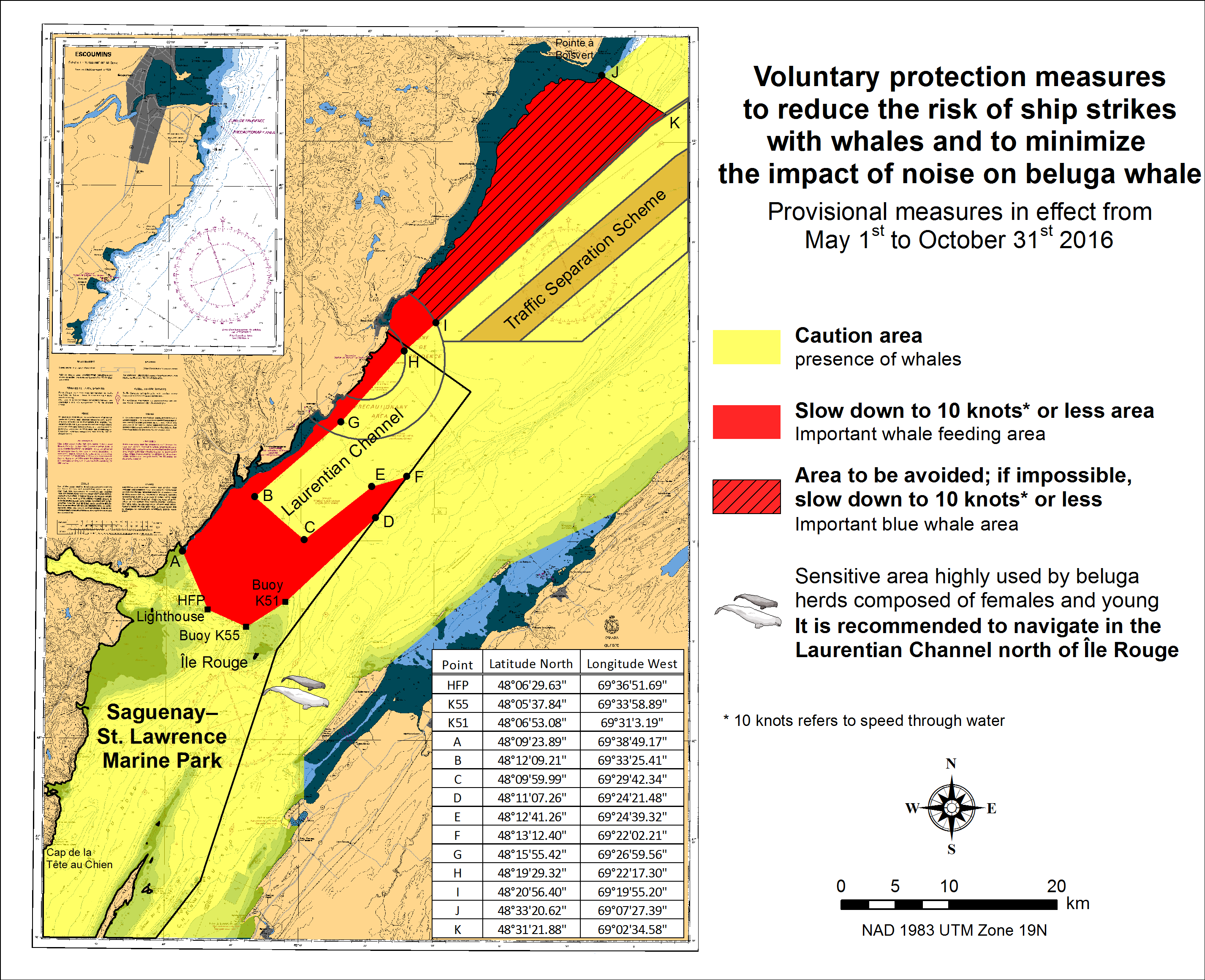
SAGUENAY-ST. LAWRENCE MARINE PARK AND SURROUNDING WATERS - WHALE PROTECTION
The waters in and around the Saguenay-St. Lawrence Marine Park are well known for their resident threatened beluga population and the wide diversity of whales that migrate there to feed, particularly between April and November.
REGULATORY PROTECTION MEASURES
All whale species that are found in the St. Lawrence are protected under the Marine Mammal Regulations, pursuant to the Fisheries Act. Within the boundaries of the Marine Park, specific measures are set out in the Marine Activities in the Saguenay-St. Lawrence Marine Park Regulations, pursuant to the Act Establishing the Saguenay-St. Lawrence Marine Park. Any collision with a marine mammal within the Marine Park must immediately be reported to a park warden at 1-866-508-9888. For collisions that occur outside the Marine Park or for any situation involving a marine mammal that is dead or in trouble, contact the emergency network at 1-877-722-5346 or on channel 16.
For more information on the Saguenay-St. Lawrence Marine Park, see section 5C of the Annual Edition of the Notices to Mariners - April 2015 to March 2016.
VOLUNTARY PROTECTION MEASURES
Provisional measures in effect from May 1st to October 31st, 2016. See map below.
These measures apply to merchant vessels and cruise ships between Pointe à Boisvert and Cap de la Tête au Chien to prevent collisions with whales. These measures should only be taken when they will not jeopardize navigational safety.
Caution area (yellow area): To reduce the risk of collisions with whales that can be present anywhere in this area, heightened vigilance of navigators is critical. Posting a lookout is recommended in order to increase the chances of seeing the whales and thus taking necessary measures to avoid them. If bypassing the whales is not possible, slow down and wait for the animals to move away to a distance greater than 400 meters (0.215 nautical miles) before resuming original speed. It is more difficult to see the animals at night therefore increased caution is recommended.
Slow down to 10 knots or less area (red area): To reduce the risk of collisions with whales in this feeding area, it is recommended that vessels slow down to a maximum speed through the water of 10 knots and post a lookout. It is further recommended to remain in the Laurentian Channel to the north of Île Rouge to minimize the impact of noise in a sensitive area south of this island, which is highly frequented by herds of beluga whales composed of females and young.
Area to be avoided (hatched red area): To reduce noise and the risk of collisions with whales, vessels should avoid transiting through this area which is highly frequented by blue whales, an endangered species. If the area cannot be avoided, slow down to a speed through the water of 10 knots or less.
CANADIAN HYDROGRAPHIC SERVICE - ANNOUNCEMENT REGARDING TIDAL INFORMATION TABLES ON CHARTS
*1001 CANADIAN HYDROGRAPHIC SERVICE - NAUTICAL CHARTS
| CHARTS | MAIN TITLE | SCALE | PUBLISHED | CAT # | PRICE |
|---|---|---|---|---|---|
| New Editions | |||||
| 2228 | Lake Huron/Lac Huron (Southern Portion/Partie sud) | 1:120000 | 24-JUN-2016 | 3 | 20.00 |
| 5352 | Payne Bay et/and Rivière Arnaud (Tuvalik Point à/to Ile Basking) | 1:30000 | 29-MAY-2015 | 4 | 20.00 |
| 5365 | Cap du Prince-De-Galles à/to Davies Island | 1:100000 | 29-MAY-2015 | 4 | 20.00 |
| 5390 | Wakeham Bay and Fisher Bay et les Approches/and Approaches | 1:37500 | 29-MAY-2015 | 4 | 20.00 |
| 5391 | Douglas Harbour et les Approches/and Approaches | 1:37500 | 29-MAY-2015 | 4 | 20.00 |
| 7646 | Putulik (Hat Island) and/et Wilkins Point | 1:15000 | 03-JUN-2016 | 4 | 12.00 |
*1002 CANADIAN HYDROGRAPHIC SERVICE - ELECTRONIC NAVIGATIONAL CHARTS
| NEW PRODUCTS | |
|---|---|
| S-57 ENC NUMBER | CHART TITLE |
| CA476598 | Forteau Bay |
*1003 CANADIAN HYDROGRAPHIC SERVICE – RASTER DIGITAL CHARTS (BSB V4).
| CHARTS | MAIN TITLE | SCALE | PUBLISHED |
|---|---|---|---|
| New Editions | |||
| RM-1236 | Pointe des Monts aux/to Escoumins | 1:200000 | 26-OCT-2012 |
| Charts Permanently Withdrawn | |||
| RM-1236 | Pointe des Monts aux/to Escoumins | ||
*1004 CANADIAN HYDROGRAPHIC SERVICE – END OF CD DISTRIBUTION OF BSB RASTER AND S-57 VECTOR CHARTS
Please be advised that the Canadian Hydrographic Service (CHS) will no longer distribute BSB raster
and S-57 vector files via CD as of December 31st, 2016.
CHS dealers may sell the 2017 edition of raster and vector charts through the CHS Digital Data Portal at
http://register-enregistrer.chs-shc.gc.ca/
Should you have any questions or concerns, please contact chsinfo@dfo-mpo.gc.ca
*1005 CANADIAN COAST GUARD - LIST OF CHARTS AND REFERENCE CHARTS (SECTION I) AFFECTED BY TEMPORARY AND PRELIMINARY NOTICES
IN EFFECT OCTOBER 28th, 2016 (REVISED AND PROMULGATED QUARTERLY)
| 1430 | 809(P)/15 | 4374 | 508(P)/15 |
| 2017 | 909(T)/14 | 4375 | 113(P)/16 |
| 2044 | 1005(T)/15 | 4376 | 302(P)/16 |
| 2060 | 814(T)/16 | 4377 | 405(P)/13 |
| 2077 | 1011(T)/16 | 4386 | 1108(P)/13 |
| 2235 | 818(T)/16 | 4396 | 820(P)/16 |
| 2315 | 1006(T)/15 515(T)/16 | 4404 | 611(P)/16 |
| 3057 | 209(P)/16 | 4422 | 1005(P)/14 |
| 3424 | 928(P)/16 | 4425 | 517(P)/16 |
| 3478 | 1013(P)/15 | 4507 | 715(P)/16 |
| 3490 | 1112(P)/14 | 4587 | 1008(P)/16 |
| 3538 | 712(P)/15 | 4644 | 1106(T)/15 |
| 3546 | 714(P)/14 | 4825 | 110(T)/16 717(P)/16 |
| 3668 | 718(P)/16 | 4830 | 1104(T)/13 716(P)/16 |
| 3800 | 115(P)/16 | 4849 | 823(P)/16 |
| 4010 | 605(P)/14 1009(P)/16 | 4863 | 109(T)/16 |
| 4049 | 610(T)/16 | 4866 | 1010(P)/16 |
| 4118 | 821(P)/16 | 4909 | 613(P)/12 810(P)/12 714(P)/16 |
| 4170 | 1109(P)/15 | 4911 | 811(P)/12 510(P)/15 |
| 4201 | 509(P)/13 | 4913 | 518(P)/16 519(P)/16 |
| 4236 | 609(P)/15 610(P)/15 | 4920 | 520(P)/16 |
| 4237 | 516 (P)/16 | 6218 | 204(T)/16 |
| 4241 | 810(P)/14 | 6267 | 1114(P)/14 |
| 4244 | 1006(T)/14 904(P)/15 | US 14853 | 1211(T)/14 |
| 4302 | 303(T)/16 822(P)/16 | US 14865 | 807(T)/15 |
| 4340 | 418(P)/14 | US 14884 | 715(T)/13 |
| 4367 | 1008(P)/15 |
*1006 BAIE PIASHTI À/TO PETITE ÎLE AU MARTEAU – UNLIT PRIVATE BUOYS DISCONTINUED.
Reference Chart: 4456
The following unlit private buoys have been discontinued:
Unlit private buoy Havre St-Pierre PRIV, NW corner of Île à la Chasse (LL 11438) (50° 13’ 50.0’’N 063° 11’ 50.0’’W)
Unlit private buoy Havre St-Pierre PRIV, NE corner of Île à la Chasse (LL 11439) (50° 14’ 34.0’’N 063° 08’ 20.0’’W)
Unlit private buoy Havre St-Pierre PRIV, SE corner of Île à la Chasse (LL 11440) (50° 13’ 56.0’’N 063° 09’ 02.0’’W)
Unlit private buoy Havre St-Pierre PRIV, SW corner of Île à la Chasse (LL 11441) (50° 13’ 40.0’’N 063° 11’ 08.0’’W)
(Q2016-130, 131, 132, 133)
*1007 CAP DE LA TÊTE AU CHIEN AU/TO CAP AUX OIES – UNLIT SCIENTIFIC BUOYS DISCONTINUED.
Reference Chart: 1234
The following unlit scientific buoys have been discontinued:
Unlit scientific buoy OUEL1 (LL 12511) (47° 30’ 27.0’’N 070° 02’ 15.0’’W)
Unlit scientific buoy OUEL2 (LL 12512) (47° 30’ 11.9’’N 070° 02’ 03.1’’W)
Unlit scientific buoy OUEL3 (LL 12513) (47° 29’ 58.9’’N 070° 01’ 54.1’’W)
Unlit scientific buoy OUEL4 (LL 12514) (47° 29’ 43.1’’N 070° 01’ 41.9’’W)
Unlit scientific buoy OUEL5 (LL 12515) (47° 29’ 30.1’’N 070° 01’ 30.0’’W)
Unlit scientific buoy OUEL6 (LL 12516) (47° 29’ 16.8’’N 070° 01’ 18.1’’W)
Unlit scientific buoy MAL1 (LL 12517) (47° 38’ 43.2’’N 070° 07’ 30.0’’W)
Unlit scientific buoy MAL2 (LL 12518) (47° 38’ 30.0’’N 070° 07’ 18.0’’W)
Unlit scientific buoy MAL3 (LL 12519) (47° 38’ 16.8’’N 070° 07’ 06.0’’W)
Unlit scientific buoy MAL4 (LL 12520) (47° 38’ 04.8’’N 070° 06’ 58.8’’W)
(Q2016-083)
*1008(P) MORTIER BAY – LIGHT TO BE PERMANENTLY DISCONTINUED
Reference Chart: 4587
The Canadian Coast Guard proposes to permanently discontinue the following aid to navigation:
Marystown Light (LL 63.5) (47º 09’ 52.2’’N 055º 08’ 50.1’’W).
Comments on this action are solicited from mariners and other interested parties.
Comments should be directed to the following within three months from the date of this notice:
Superintendent, Renee Pope
Aids to Navigation,
Canadian Coast Guard,
P.O. Box 5667,
St. John’s, NL,
A1C 5X1
Telephone: (709) 772-2800
Email: renee.pope@dfo-mpo.gc.ca
Any objections must state the facts on which they are based and should include supporting information on safety, commerce and public benefit.
(N2016-065)
*1009(P) BAY OF FUNDY / BAIE DE FUNDY: INNER PORTION / PARTIE INTÉRIEURE – FOG HORN TO BE PERMANENTLY DISCONTINUED
Reference Chart: 4010
The Canadian Coast Guard proposes to permanently discontinue the fog horn of the following aid to navigation:
Advocate Harbour (LL 166) (49º 19’ 07.1’’N 064º 46’ 59.9’’W). The light and structure to remain.
Comments on this action are solicited from mariners and other interested parties.
Comments should be directed to the following within three months from the date of this notice:
Superintendent, Renee Pope
Aids to Navigation,
Canadian Coast Guard,
P.O. Box 5667,
St. John’s, NL,
A1C 5X1
Telephone: (709) 772-2800
Email: renee.pope@dfo-mpo.gc.ca
Any objections must state the facts on which they are based and should include supporting information on safety, commerce and public benefit.
(F2016-056)
*1010(P) BOTWOOD AND APPROACHES / ET LES APPROCHES – LIGHT TO BE PERMANENTLY DISCONTINUED
Reference Chart: 4866
The Canadian Coast Guard proposes to permanently discontinue the following aid to navigation:
Porterville Wharf Light (LL 352.5) (49º 15’ 26.0’’N 055º 11’ 33.0’’W)
Comments on this action are solicited from mariners and other interested parties.
Comments should be directed to the following within three months from the date of this notice:
Superintendent, Renee Pope
Aids to Navigation,
Canadian Coast Guard,
P.O. Box 5667,
St. John’s, NL,
A1C 5X1
Telephone: (709) 772-2800
Email: renee.pope@dfo-mpo.gc.ca
Any objections must state the facts on which they are based and should include supporting information on safety, commerce and public benefit.
(N2016-063)
*1011(T) LAKE ONTARIO/LAC ONTARIO (WESTERN PORTION/PARTIE OUEST) – SILTING REPORTED.
Reference Chart: 2077
Silting reported in main entrance channel to Fifty Point Marina. Centre of channel depth
reported to be 1.9 metres with shallower depths on the sides.
Mariners are requested to use caution in the area.
(NOTSHIP C2266/16)
SECTION 2 - CHART CORRECTIONS
1203 - Tadoussac à/to Cap Éternité - New Edition - 17-JUN-2011 - NAD 1983
| 28-OCT-2016 | LNM/D. 19-AUG-2016 | ||
| Amend | vertical clearance of 92 metres, to read 89 metres
(See Chart No. 1, D22) |
48°08′47.4″N 069°48′36.1″W | |
| This notice affects Electronic Navigational Chart: CA379232, CA479053 | |||
| DFO(6409555-01) | |||
| Amend |
vertical clearance of 49 metres, to read 47 metres
(See Chart No. 1, D22) |
48°13′58.6″N 069°55′54.7″W | |
| This notice affects Electronic Navigational Chart: CA479053 | |||
| DFO(6409556-01) | |||
1203 - Continuation A - New Edition - 17-JUN-2011 - NAD 1983
| 28-OCT-2016 | LNM/D. 19-AUG-2016 | |||
| Add | isolated floating breakwater, Bkw |
joining 48°14′38.7″N 070°10′54.3″W 48°14′40.8″N 070°10′55.6″W and 48°14′42.9″N 070°10′50.2″W |
||
| (See Chart No. 1, F4.1) | ||||
| This notice affects Electronic Navigational Chart: CA479087 | ||||
| DFO(6409472-01) | ||||
| Add |
private light Fl R (Priv)
(See Chart No. 1, P1) |
48°14′42.9″N 070°10′50.2″W | ||
| This notice affects Electronic Navigational Chart: CA479087 | ||||
| DFO(6409472-02) | ||||
| Amend |
F G (Priv) to read Fl G (Priv) against light
(See Chart No. 1, P16) |
48°14′43.2″N 070°10′48.7″W | ||
| This notice affects Electronic Navigational Chart: CA479087 | ||||
| LL(11652.0) DFO(6409472-03) | ||||
1233 - L'Isle-aux-Coudres - New Edition - 11-MAY-2012 - NAD 1983
| 21-OCT-2016 | LNM/D. 30-SEP-2016 | |||
| Affix | Patch | 47°25′16.0″N 070°23′35.0″W | ||
|
Download Patch - http://www.chs-shc.gc.ca/patches/PA1233-20160914.pdf |
||||
| This notice affects Electronic Navigational Chart: CA579023 | ||||
| DFO(6409513-01) | ||||
1236 - Rimouski - New Edition - 26-OCT-2012 - NAD 1983
| 07-OCT-2016 | LNM/D. 12-AUG-2016 | ||
| Amend |
depth over the submerged crib of 10 metres 8 decimetres
to read 8 metres 6 decimetres (See Chart No. 1, Ka, L43) |
48°31′25.3″N 068°28′33.2″W | |
| This notice affects Electronic Navigational Chart: CA579041 | |||
| DFO(6409323-01) | |||
1310 - Section B-C - New Edition - 10-JAN-2014 - NAD 1983
| 14-OCT-2016 | LNM/D. 12-AUG-2016 | ||
| Add | Chenal balisé (Priv) / Channel Buoyed (Priv) | 45°36′09.0″N 073°28′19.0″W | |
| This notice affects Electronic Navigational Chart: CA579080 | |||
| (Q2016113) DFO(6409502-01) | |||
| Replace |
note
VITESSE B La vitesse maximale PAR RAPPORT AU FOND est de 6 nœuds dans le Canal de la Rive Sud. SPEED B The speed limit OVER THE BOTTOM is 6 knots in the Canal de la Rive Sud. with VITESSE B Se référer au MANUEL DE LA VOIE MARITIME pour les limites de vitesse en vigueur. SPEED B Refer to SEAWAY HANDBOOK for applicable speed limits. |
45°31′22.0″N 073°30′26.0″W | |
| This notice affects Electronic Navigational Chart: CA579080 | |||
| DFO(6409527-01) | |||
1316 - Port de Québec - New Edition - 02-DEC-2011 - NAD 1983
| 28-OCT-2016 | LNM/D. 15-JAN-2016 | |||
| Amend |
vertical clearance of 1 metre 5 decimetres, to read 1 metre 2 decimetres
(See Chart No. 1, D22) |
46°53′06.4″N 071°08′42.0″W | ||
| This notice affects Electronic Navigational Chart: CA479082, CA579003 | ||||
| DFO(6409552-01) | ||||
1317 - Sault-au-Cochon à/to Québec - New Edition - 22-JUN-2012 - NAD 1983
| 28-OCT-2016 | LNM/D. 16-SEP-2016 | ||
| Add |
note
DIAGRAMME/Voir Instructions nautiques DIAGRAM/See Sailing Directions (See Chart No. 1, A18) |
46°55′56.0″N 070°42′48.0″W | |
| DFO(6409558-01) | |||
1317 - Continuation A - New Edition - 22-JUN-2012 - NAD 1983
| 28-OCT-2016 | LNM/D. 16-SEP-2016 | ||
| Amend |
vertical clearance of 1 metre 5 decimetres, to read 1 metre 2 decimetres
(See Chart No. 1, D22) |
46°53′04.0″N 071°08′44.4″W | |
| This notice affects Electronic Navigational Chart: CA479082, CA579003 | |||
| DFO(6409552-01) | |||
1320 - Île du Bic au/to Cap de la Tête au Chien - New Chart - 26-AUG-2011 - NAD 1983
| 28-OCT-2016 | LNM/D. 23-SEP-2016 | ||
| Amend |
vertical clearance of 92 metres, to read 89 metres
(See Chart No. 1, D22) |
48°08′44.7″N 069°48′30.3″W | |
| This notice affects Electronic Navigational Chart: CA379232, CA479053 | |||
| DFO(6409555-01) | |||
1429 - Canal de la Rive Sud - New Chart - 09-APR-2010 - NAD 1983
| 14-OCT-2016 | LNM/D. 29-JAN-2016 | ||
| Delete | overhead cable with vertical clearance of 13 metres |
joining 45°28′17.1″N 073°30′14.3″W 45°28′10.0″N 073°30′02.0″W and 45°28′02.9″N 073°29′49.3″W |
|
| (See Chart No. 1, D22, D27) | |||
| This notice affects Electronic Navigational Chart: CA579227 | |||
| DFO(6409511-01) | |||
| Add | overhead cable with vertical clearance of 17 metres |
joining 45°28′21.3″N 073°30′17.4″W 45°28′19.2″N 073°30′12.7″W 45°28′09.9″N 073°29′51.2″W and 45°28′04.2″N 073°29′38.2″W |
|
| (See Chart No. 1, D22, D27) | |||
| This notice affects Electronic Navigational Chart: CA579227 | |||
| DFO(6409511-02) | |||
| Replace |
Islet with obstruction with known depth of
0 metres 8 decimetres. (See Chart No. 1, K10, K41) |
45°28′10.0″N 073°30′02.0″W | |
| This notice affects Electronic Navigational Chart: CA579227 | |||
| DFO(6409511-03) | |||
| Add | fixed bridge under construction (2015) |
joining 45°28′14.2″N 073°32′05.6″W 45°28′12.0″N 073°31′15.9″W 45°28′08.6″N 073°30′33.1″W 45°28′03.7″N 073°29′48.3″W 45°28′01.8″N 073°29′48.7″W 45°28′06.9″N 073°30′38.5″W 45°28′10.0″N 073°31′17.9″W and 45°28′11.8″N 073°32′04.4″W |
|
| (See Chart No. 1, D20.1, F32) | |||
| This notice affects Electronic Navigational Chart: CA579227 | |||
| DFO(6409511-04) | |||
| Replace |
note
VITESSE Les vitesses maximales PAR RAPPORT AU FOND sont les suivantes : -6 nœuds dans le canal de la Rive Sud. -10.5 nœuds de l′entrée supérieure du canal de la Rive Sud au lac Saint-Louis, bouée A13. SPEED Speed limits OVER THE BOTTOM are as follows: -6 knots in the Canal de la Rive Sud. -10.5 knots from the Upper entrance of the Canal de la Rive Sud to Lac Saint-Louis, buoy A13. with VITESSE Se référer au MANUEL DE LA VOIE MARITIME pour les limites de vitesse en vigueur. SPEED Refer to SEAWAY HANDBOOK for applicable speed limits. |
45°29′00.0″N 073°42′00.0″W | |
| This notice affects Electronic Navigational Chart: CA579227 | |||
| DFO(6409527-02) | |||
1430 - Lac Saint-Louis - New Chart - 16-APR-2010 - NAD 1983
| 14-OCT-2016 | LNM/D. 05-AUG-2016 | |||
| Replace |
note
VITESSE Les vitesses maximales PAR RAPPORT AU FOND sont les suivantes: -6 nœuds dans le canal de la Rive Sud. -10.5 nœuds de l′entrée supérieure du canal de la Rive Sud au lac Saint-Louis, bouée A13. -16 nœuds de la bouée A13 à l′entrée inférieure de l′écluse Beauharnois. SPEED Speed limits OVER THE BOTTOM are as follows: -6 knots in the Canal de la Rive Sud. -10.5 knots from the Upper entrance of the Canal de la Rive Sud to Lac Saint-Louis, buoy A13. -16 knots from the buoy A13 to the Lower entrance of the Beauharnois Lock. with VITESSE Se référer au MANUEL DE LA VOIE MARITIME pour les limites de vitesse en vigueur. SPEED Refer to SEAWAY HANDBOOK for applicable speed limits. |
45°18′26.0″N 073°50′30.0″W | ||
| This notice affects Electronic Navigational Chart: CA479228 | ||||
| DFO(6409527-03) | ||||
1434 - B à/to C - New Edition - 24-APR-2015 - World Geodetic System 1984
| 07-OCT-2016 | |||
| Delete |
green port hand can buoy, marked 121A
(See Chart No. 1, Q21) |
44°46′21.1″N 075°23′37.2″W | |
| This notice affects Electronic Navigational Chart: CA473111 | |||
| (B2016003) DFO(6604242-01) | |||
| Delete |
green port hand can buoy, marked 121
(See Chart No. 1, Qg) |
44°46′35.7″N 075°23′05.9″W | |
| This notice affects Electronic Navigational Chart: CA473111 | |||
| (B2016004) DFO(6604243-01) | |||
1435 - Cardinal to/à Whaleback Shoal A-B - New Edition - 26-JUN-2015 - World Geodetic System 1984
| 07-OCT-2016 | |||
| Delete |
green port hand can buoy, marked 121A
(See Chart No. 1, Qg) |
44°46′21.1″N 075°23′37.2″W | |
| This notice affects Electronic Navigational Chart: CA473111 | |||
| (B2016003) DFO(6604242-01) | |||
| Delete |
green port hand can buoy, marked 121
(See Chart No. 1, Qg) |
44°46′35.7″N 075°23′05.9″W | |
| This notice affects Electronic Navigational Chart: CA473111 | |||
| (B2016004) DFO(6604243-01) | |||
1510 - Carillon - Sheet/Feuille 1 - New Edition - 04-JUN-2010 - NAD 1983
| 14-OCT-2016 | LNM/D. 20-MAY-2016 | ||
| Add |
starboard hand daybeacon
(See Chart No. 1, Qt) |
45°33′58.7″N 074°22′33.8″W | |
| This notice affects Electronic Navigational Chart: CA579157 | |||
| (Q2016126) DFO(6409530-01) | |||
| Add |
port hand daybeacon
(See Chart No. 1, Qt) |
45°33′57.3″N 074°22′35.5″W | |
| This notice affects Electronic Navigational Chart: CA579157 | |||
| (Q2016127) DFO(6409531-01) | |||
4020 - Strait of Belle Isle / Détroit de Belle Isle - New Edition - 26-JUL-2002 - NAD 1983
| 21-OCT-2016 | LNM/D. 06-MAY-2016 | ||
| Add | submarine cable area |
joining 51°21′46.0″N 056°38′35.0″W 51°22′14.0″N 056°39′08.0″W 51°21′57.0″N 056°47′16.0″W 51°21′12.0″N 056°54′31.0″W 51°22′53.0″N 056°56′21.0″W 51°24′48.0″N 056°54′51.0″W 51°25′36.0″N 056°57′14.0″W 51°26′18.0″N 056°56′34.0″W 51°25′11.0″N 056°53′15.0″W 51°22′51.0″N 056°54′45.0″W 51°22′13.0″N 056°53′59.0″W 51°22′53.0″N 056°47′23.0″W 51°23′11.0″N 056°39′16.0″W and 51°22′09.0″N 056°37′31.0″W |
|
| (See Chart No. 1, L30.2) | |||
| This notice affects Electronic Navigational Chart: CA276138, CA376094 | |||
| DFO(6307716-01) | |||
4021 - Pointe Amour à / to Cape Whittle et / and Cape George - New Edition - 01-NOV-2002 - NAD 1983
| 21-OCT-2016 | LNM/D. 06-MAY-2016 | ||
| Add | submarine cable area |
joining 51°21′50.0″N 056°38′40.0″W 51°22′14.0″N 056°39′08.0″W 51°21′12.0″N 056°54′31.0″W 51°22′53.0″N 056°56′21.0″W 51°24′48.0″N 056°54′51.0″W 51°25′33.0″N 056°57′08.0″W 51°26′18.0″N 056°56′32.0″W 51°25′11.0″N 056°53′15.0″W 51°22′38.0″N 056°54′20.0″W 51°23′11.0″N 056°39′16.0″W and 51°22′10.0″N 056°37′32.0″W |
|
| (See Chart No. 1, L30.2) | |||
| This notice affects Electronic Navigational Chart: CA276138, CA376094 | |||
| DFO(6307716-01) | |||
4023 - Northumberland Strait / Détroit de Northumberland - New Edition - 27-DEC-2002 - NAD 1983
| 21-OCT-2016 | LNM/D. 17-JUN-2016 | ||
| Amend |
F 13M to read Fl 4s9M against light
(See Chart No. 1, P16) |
45°38′50.0″N 061°37′28.0″W | |
| This notice affects Electronic Navigational Chart: CA276286, CA376242 | |||
| (G2016125) LL(887) DFO(6307706-01) | |||
4098 - Sable Island / Île de Sable - New Edition - 30-NOV-2001 - NAD 1983
| 21-OCT-2016 | LNM/D. 27-FEB-2015 | ||
| Delete |
light RLts
(See Chart No. 1, P1) |
43°55′58.0″N 060°01′43.0″W | |
| This notice affects Electronic Navigational Chart: CA376289 | |||
| DFO(6307739-01) | |||
4099 - Sable Island / Île de Sable: Western Portion / Partie Ouest - New Edition - 28-DEC-2001 - NAD 1983
| 21-OCT-2016 | LNM/D. 05-FEB-2016 | ||
| Delete |
light Rlts
(See Chart No. 1, P1) |
43°55′58.0″N 060°01′43.0″W | |
| This notice affects Electronic Navigational Chart: CA376289 | |||
| DFO(6307739-01) | |||
4210 - Cape Sable to / à Pubnico Harbour - New Chart - 05-APR-1991 - NAD 1983
| 07-OCT-2016 | LNM/D. 06-MAY-2016 | ||
| Add |
private light Fl R(Priv)
(See Chart No. 1, P65) |
43°27′35.6″N 065°39′07.4″W | |
| This notice affects Electronic Navigational Chart: CA476043 | |||
| LL(319.2) DFO(6307681-01) | |||
| Add |
light FlG
(See Chart No. 1, P65) |
43°27′35.4″N 065°39′04.9″W | |
| This notice affects Electronic Navigational Chart: CA476043 | |||
| LL(319.4) DFO(6307681-03) | |||
| Add | breakwater with legend Bkw |
joining 43°27′35.4″N 065°39′04.9″W 43°27′34.6″N 065°38′57.6″W 43°27′32.2″N 065°38′58.0″W and 43°27′30.8″N 065°38′55.1″W |
|
| (See Chart No. 1, F4.1) | |||
| This notice affects Electronic Navigational Chart: CA476043 | |||
| DFO(6307681-04) | |||
4386 - Hubbards Cove - New Edition - 16-JUL-2004 - NAD 1983
| 07-OCT-2016 | LNM/D. 12-AUG-2016 | ||
| Add |
red starboard hand lighted spar buoy FlR, marked DY52
(See Chart No. 1, Qf) |
44°37′01.7″N 064°02′21.8″W | |
| This notice affects Electronic Navigational Chart: CA476197 | |||
| (F2016047) LL( 479) DFO(6307690-03) | |||
4386 - St. Margaret's Bay - New Edition - 16-JUL-2004 - NAD 1983
| 07-OCT-2016 | LNM/D. 12-AUG-2016 | ||
| Replace | red starboard hand lighted pillar bell buoy FlR, marked DY52 with red starboard hand lighted spar buoy FlR, marked DY52 | 44°36′43.3″N 064°02′35.7″W | |
| This notice affects Electronic Navigational Chart: CA476195 | |||
| (F2016047) LL(479) DFO(6307690-01) | |||
| Reposition | red starboard hand lighted spar buoy FlR, marked DY52 |
from 44°36′43.3″N 064°02′35.7″W to 44°37′01.7″N 064°02′21.8″W |
|
| (See Chart No. 1, Qf) | |||
| This notice affects Electronic Navigational Chart: CA476195 | |||
| (F2016047) LL( 479) DFO(6307690-02) | |||
4447 - Pomquet and Tracadie Harbours / Havres de Pomquet et Tracadie - New Edition - 07-SEP-2001 - NAD 1983
| 21-OCT-2016 | LNM/D. 06-MAY-2016 | ||
| Amend |
F to read Fl 4s against light
(See Chart No. 1, P16) |
45°38′44.9″N 061°37′32.3″W | |
| This notice affects Electronic Navigational Chart: CA276286, CA376242 | |||
| (G2016125) LL(887) DFO(6307706-01) | |||
4452 - Baie Johan-Beetz et/and Baie Piashti - New Edition - 22-MAR-2013 - NAD 1983
| 28-OCT-2016 | LNM/D. 09-SEP-2016 | ||
| Delete | slipway |
between 50°17′15.2″N 062°48′23.0″W and 50°17′15.4″N 062°48′21.2″W |
|
| (See Chart No. 1, F23) | |||
| This notice affects Electronic Navigational Chart: CA579134 | |||
| DFO(6409549-01) | |||
| Delete |
ramp
(See Chart No. 1, Ud) |
50°17′15.3″N 062°48′24.3″W | |
| This notice affects Electronic Navigational Chart: CA579134 | |||
| DFO(6409549-02) | |||
| Delete | pier in ruins, Ru |
between 50°17′15.4″N 062°48′23.3″W and 50°17′15.9″N 062°48′21.5″W |
|
| (See Chart No. 1, F14, F33.1) | |||
| This notice affects Electronic Navigational Chart: CA579134 | |||
| DFO(6409549-04) | |||
| Add |
ramp
(See Chart No. 1, Ud) |
50°17′18.9″N 062°48′13.8″W | |
| This notice affects Electronic Navigational Chart: CA579134 | |||
| DFO(6409549-05) | |||
4456 - Baie Piashti à/to Petite Île au Marteau - New Edition - 30-AUG-2013 - NAD 1983
| 14-OCT-2016 | LNM/D. 27-MAY-2016 | ||
| Delete | marine farm
(See Chart No. 1, K48.2) |
50°13′53.6″N 063°11′13.1″W | |
| This notice affects Electronic Navigational Chart: CA379131 | |||
| DFO(6409536-01) | |||
| Delete |
marine farm
(See Chart No. 1, K48.2) |
50°14′04.9″N 063°09′23.3″W | |
| This notice affects Electronic Navigational Chart: CA379131 | |||
| DFO(6409536-02) | |||
4462 - St George's Bay - New Edition - 07-MAR-2003 - NAD 1983
| 21-OCT-2016 | LNM/D. 09-SEP-2016 | ||
| Amend |
F 53ft13M to read Fl 4s53ft9M against light
(See Chart No. 1, P16) |
45°38′46.3″N 061°37′33.5″W | |
| This notice affects Electronic Navigational Chart: CA276286, CA376242 | |||
| (G2016125) LL(887) DFO(6307706-01) | |||
4468 - Île du Petit Mécatina aux/to Îles Sainte-Marie - New Edition - 27-FEB-2015 - NAD 1983
| 21-OCT-2016 | LNM/D. 08-JUL-2016 | ||
| Add |
yellow cautionary can buoy, marked CC
(See Chart No. 1, Qm) |
50°27′35.0″N 059°36′46.1″W | |
| This notice affects Electronic Navigational Chart: CA379115 | |||
| (Q2016139) DFO(6409554-01) | |||
4472 - Baie des Homards à/to Île de la Grande Passe - New Edition - 14-AUG-1981 - NAD 1927
| 21-OCT-2016 | LNM/D. 08-JUL-2016 | ||
| Amend |
vertical clearance of 129 feet, to read 126 feet
(See Chart No. 1, D22) |
51°20′23.0″N 058°17′01.0″W | |
| DFO(6409541-01) | |||
| Affix | Patch | 51°19′04.8″N 058°10′38.3″W | |
|
Download Patch - http://www.chs-shc.gc.ca/patches/PA4472_20160829.pdf |
|||
| DFO(6409548-01) | |||
4473 - Île de la Grande Passe aux/to Îles Bun - New Edition - 28-OCT-2005 - NAD 1983
| 21-OCT-2016 | LNM/D. 08-JUL-2016 | ||
| Affix | Patch | 51°13′46.0″N 058°43′30.0″W | |
|
Download Patch - http://www.chs-shc.gc.ca/patches/PA4473_20160902.pdf |
|||
| DFO(6409550-01) | |||
| Amend |
vertical clearance of 4 metres 2 decimetres, to read 4 metres 1 decimetre
(See Chart No. 1, D22) |
51°13′12.4″N 058°39′20.8″W | |
| DFO(6409553-01) | |||
| Amend |
vertical clearance of 5 metres 9 decimetres, to read 8 metres 0 decimetres
(See Chart No. 1, D22) |
51°13′29.2″N 058°39′13.7″W | |
| DFO(6409553-02) | |||
4474 - Îles Bun à/to Baie des Moutons - New Edition - 28-MAY-1999 - NAD 1983
| 21-OCT-2016 | LNM/D. 08-JUL-2016 | |||
| Affix | Patch | 51°03′50.0″N 058°56′00.0″W | ||
|
Download Patch http://www.chs-shc.gc.ca/patches/PA4474_20160902.pdf |
||||
| DFO(6409551-01) | ||||
4507 - St Lunaire Bay - New Edition - 05-DEC-2003 - NAD 1983
| 07-OCT-2016 | LNM/D. 13-MAY-2016 | ||
| Reposition | green port hand lighted spar buoy FlG, marked KN3 |
from 51°30′01.6″N 055°28′33.5″W to 51°30′00.2″N 055°28′36.7″W |
|
| (See Chart No. 1, Qg) | |||
| (N2016023) LL(239.24) DFO(6307703-01) | |||
| Reposition | green port hand lighted spar buoy FlG, marked KN5 |
from 51°30′01.7″N 055°28′31.1″W to 51°30′02.5″N 055°28′33.1″W |
|
| (See Chart No. 1, Qg) | |||
| (N2016024) LL(239.25) DFO(6307704-01) | |||
4512 - Quirpon Harbour and Approaches / et les approches - New Edition - 24-JAN-2003 - NAD 1983
| 21-OCT-2016 | LNM/D. 24-JUN-2016 | ||
| Replace | yellow and black South cardinal lighted pillar buoy Q(6)+LFl 15s, marked KQV with yellow and black South cardinal lighted spar buoy Q(6)+LFl 15s, marked KQV | 51°35′17.5″N 055°27′14.4″W | |
| (N2016044) LL(237.1) DFO(6307685-01) | |||
| Reposition |
yellow and black South cardinal lighted spar buoy Q(6)+LFl 15s, marked KQV
marked KQV |
from 51°35′17.5″N 055°27′14.4″W to 51°35′16.8″N 055°27′11.4″W |
|
| (See Chart No. 1, Q130.3) | |||
| (N2016044) LL(237.1) DFO(6307685-02) | |||
| Replace | black and yellow North cardinal lighted pillar buoy Q, marked KQ with black and yellow North cardinal lighted spar buoy Q, marked KQ | 51°35′14.6″N 055°27′15.2″W | |
| (N2016043) LL(237.2) DFO(6307685-03) | |||
| Reposition | black and yellow North cardinal lighted spar buoy Q, marked KQ |
from 51°35′14.6″N 055°27′15.2″W to 51°35′16.6″N 055°27′11.9″W |
|
| (See Chart No. 1, Q130.3) | |||
| (N2016043) LL(237.2) DFO(6307685-04) | |||
4641 - Port aux Basques - New Edition - 31-OCT-2014 - NAD 1983
| 07-OCT-2016 | LNM/D. 01-MAY-2015 | ||
| Reposition |
private yellow ODAS/SADO lighted pillar
Fl(5) Y 20s. |
from 47°33′48.0″N 059°06′00.0″W to 47°33′48.0″N 059°06′12.0″W |
|
| (See Chart No. 1, Q58) | |||
| This notice affects Electronic Navigational Chart: CA376625, CA576304 | |||
| DFO(6307689-01) | |||
4670 - Forteau Bay - New Edition - 13-JUN-2003 - NAD 1983
| 21-OCT-2016 | LNM/D. 06-MAY-2016 | ||
| Add | submarine cable area |
joining 51°25′36.6″N 056°57′18.5″W 51°24′48.1″N 056°54′50.9″W and 51°22′55.5″N 056°56′18.5″W |
|
| (See Chart No. 1, L30.2) | |||
| This notice affects Electronic Navigational Chart: CA276138, CA376094 | |||
| DFO(6307716-01) | |||
| Add | submarine cable area |
joining 51°26′20.1″N 056°56′44.9″W 51°25′11.4″N 056°53′14.8″W and 51°22′55.5″N 056°54′42.0″W |
|
| (See Chart No. 1, L30.2) | |||
| This notice affects Electronic Navigational Chart: CA476598 | |||
| DFO(6307716-02) | |||
4823 - Cape Ray to / à Garia Bay - New Chart - 16-JAN-2004 - NAD 1983
| 07-OCT-2016 | LNM/D. 22-NOV-2013 | ||
| Reposition |
private yellow ODAS/SADO lighted buoy
Fl (5)Y20s. |
from 47°33′46.0″N 059°06′00.0″W to 47°33′48.0″N 059°06′12.0″W |
|
| (See Chart No. 1, Q58) | |||
| This notice affects Electronic Navigational Chart: CA376625, CA576304 | |||
| DFO(6307689-01) | |||
4847 - Conception Bay - New Edition - 03-AUG-2001 - NAD 1983
| 28-OCT-2016 | LNM/D. 26-SEP-2014 | ||
| Amend |
Fl R 6s to read Fl Y 5s against light
(See Chart No. 1, P16) |
47°44′14.5″N 053°13′26.4″W | |
| This notice affects Electronic Navigational Chart: CA376120, CA476405, CA576416 | |||
| (N2016053) LL(478) DFO(6307707-01) | |||
4849 - Harbour Grace and / et Carbonear - New Chart - 30-DEC-1988 - NAD 1983
| 28-OCT-2016 | LNM/D. 24-JUL-2015 | ||
| Amend |
Fl R to read Fl Y against light
(See Chart No. 1, P16) |
47°44′14.5″N 053°13′26.4″W | |
| This notice affects Electronic Navigational Chart: CA376120, CA476405, CA576416 | |||
| (N2016053) LL(478) DFO(6307707-01) | |||
4849 - Public Wharf / Quai - New Chart - 30-DEC-1988 - NAD 1983
| 28-OCT-2016 | LNM/D. 24-JUL-2015 | ||
| Amend |
Fl R to read Fl Y against light
(See Chart No. 1, P16) |
47°44′14.5″N 053°13′26.4″W | |
| This notice affects Electronic Navigational Chart: CA376120, CA476405, CA576416 | |||
| (N2016053) LL(478) DFO(6307707-01) | |||
4850 - Cape St Francis to / à Baccalieu Island and / et Heart's Content - New Chart - 11-MAY-1990 - NAD 1983
| 07-OCT-2016 | LNM/D. 21-NOV-2014 | ||
| Reposition | red starboard hand lighted pillar buoy Fl R, marked CV2. |
from 48°04′56.8″N 052°54′09.1″W to 48°05′01.5″N 052°54′04.9″W |
|
| (See Chart No. 1, Qf) | |||
| This notice affects Electronic Navigational Chart: CA376146 | |||
| (N2016055) LL(474.0) DFO(6307687-01) | |||
| Replace |
red starboard hand pillar light buoy Fl R, marked CV2, with red starboard hand spar light buoy Fl R, marked CV2
(See Chart No. 1, Qf) |
48°05′01.5″N 052°54′04.9″W | |
| This notice affects Electronic Navigational Chart: CA376146 | |||
| (N2016055) LL(474.0) DFO(6307687-02) | |||
4864 - Black Island to / à Little Denier Island - New Chart - 25-AUG-2006 - NAD 1983
| 28-OCT-2016 | LNM/D. 07-OCT-2016 | |||
| Delete |
light Fl G
(See Chart No. 1, P1) |
49°19′18.0″N 055°02′00.7″W | ||
| This notice affects Electronic Navigational Chart: CA476168 | ||||
| (N2016056P) LL(352.9) DFO(6307712-01) | ||||
| 07-OCT-2016 | LNM/D. 24-JUN-2016 | |||
| Add |
red starboard hand lighted spar buoy QR, marked DSP2
(See Chart No. 1, Qf) |
49°21′14.2″N 055°01′44.8″W | ||
| This notice affects Electronic Navigational Chart: CA476168 | ||||
| (N2013024) LL(352.97) DFO(6307700-01) | ||||
4865 - Approaches to / Approches à Lewisporte and / et Loon Bay - New Edition - 27-MAY-2005 - NAD 1983
| 28-OCT-2016 | LNM/D. 07-OCT-2016 | |||
| Delete |
light Fl G
(See Chart No. 1, P1) |
49°19′18.0″N 055°02′00.7″W | ||
| This notice affects Electronic Navigational Chart: CA476168 | ||||
| (N2016056P) LL(352.9) DFO(6307712-01) | ||||
| 07-OCT-2016 | LNM/D. 13-MAR-2015 | |||
| Add |
red starboard hand lighted spar buoy QR, marked DSP2
(See Chart No. 1, Qf) |
49°21′14.2″N 055°01′44.8″W | ||
| This notice affects Electronic Navigational Chart: CA476168 | ||||
| (N2013024) LL(352.97) DFO(6307700-01) | ||||
5049 - Davis Inlet to/aux Seniarlit Islands - New Edition - 25-JUN-1999 - NAD 1983
| 07-OCT-2016 | LNM/D. 01-JUL-2016 | ||
| Amend |
ON CERTAIN COPIES
′Alternate Route / Route alternative′ to read ′Route Usually Followed/Route normalement naviguée′ |
56°10′41.4″N 060°51′51.4″W | |
| DFO(6307688-01) | |||
SECTION 3 - RADIO AIDS TO MARINE NAVIGATION CORRECTIONS
NO CORRECTIONS FOR THIS SECTION.
SECTION 4 - SAILING DIRECTIONS AND SMALL CRAFT GUIDE CORRECTIONS
ATL 105 — Cape Canso to Cape Sable (including Sable Island), Second Edition, 2014 —
Chapter 3 — Paragraph 122
Delete: “A light (495) … from the light tower.”
Replace by: A light (495) is shown from a skeleton tower, having red and white daymarks on Brig Point. A former
light structure stands nearby.
(A2016-005.6)
ATL 106 — Gulf of Maine and Bay of Fundy, First Edition, 2001 —
Chapter 2 — Paragraph 108
Delete: “A light (197) … inner end of the breakwater.”
Replace by: A light (197.3) is shown from a mast, having a red triangular daymark, near the outer end of the breakwater.
(A2016-006.14)
ATL 108 — Gulf of St. Lawrence (Southwest Portion), First Edition, 2006 —
Chapter 3 — Paragraph 30, after “Fairway light”
Delete: and bell
(A2016-008.11)
ATL 109 — Gulf of St. Lawrence (Northeast Portion), First Edition, 2006 —
Chapter 2 — Paragraph 86, after “a vertical clearance of”
Delete: 129 feet (39.3 m)
Replace by: 126 feet (38.4 m)
(Q2016-052.1)
ATL 110 — St. Lawrence River — Cap Whittle/Cap Gaspé to Les Escoumins and Anticosti Island, Third Edition, 2011 —
Chapter 1 — Paragraph 100
Delete: There is a slipway for small craft south
Replace by: There is a launching ramp east
(Q2016-053.1)
Chapter 1 — Delete paragraph 117
Replace by: 117 There is a strong tidal stream in the vicinity of Île à Mouton.
(Q2016-051.1)
ATL 111 — St. Lawrence River — Île Verte to Québec and Fjord du Saguenay, Third Edition, 2007 —
Chapter 1 — Paragraph 79, after “with a clearance of”
Delete: 2.9 m
Replace by: 3.3 m
(Q2016-022.1)
Chapter 1 — Paragraph 113, after “NW and NE faces;”
Delete: the depth is 4.2 m alongside the SW face.
Replace by: the SW face has depths of 2.6 to 4.2 m alongside.
(Q2016-059.1)
Chapter 2 — In the vicinity of paragraph 4, Table 2.2 Summary of air obstructions for this booklet
Make the following changes in the “Bridge/Bare cable” and “Cable with ice” columns.
| Location | Bridge/Bare cable | Cable with ice |
|---|---|---|
| Cap de la Boule | 89m | 78m |
| Cap Sainte-Marguerite | 47m | 43m |
| Anse de Tabatière | 62m | 50m |
| Pointe Sainte-Anne (Chicoutimi) | 3,1m |
(Q2016-050.1)
Chapter 3 — Paragraph 103.1, last line
Add: There are lights (1875.9, 1875.8) on each end of the breakwaters, at the entrance to the basin.
(Q2016-048.1)
Chapter 3 — In the vicinity of paragraph 136
Insert the new diagram of BERTHIER-SUR-MER that is provided in Section 4 of this Monthly Edition.
https://www.notmar.gc.ca/publications/monthly-mensuel/images/ed102016-part4-atl111-berthiersurmer.pdf
(Q2016-058.1)
Chapter 3 — Delete paragraph 136
Replace by: 136 A marina (Le Havre de Berthier-sur-Mer), protected by a breakwater, is situated in
Trou de Berthier; the approach to the marina is marked with private buoys and leading lights. There
are perches indicating the drying area. (For further information on facilities, consult the Appendices.)
A floating wharf used by tour boats is situated near the end of the breakwater. The approach to the small
craft basin is restricted by a shoal with a depth of 0.3 m (2015). (See the Berthier-sur-Mer diagram.)
(Q2016-058.2)
Chapter 4 — Paragraph 36, after “with a minimum vertical clearance of”
Delete: 92 m or *72 m
Replace by: 89 m or *78 m
(Q2016-050.7)
Chapter 4 — Paragraph 44, after “a vertical clearance of”
Delete: 49 m or *data not available
Replace by: 47 m or *43 m
(Q2016-050.8)
Chapter 4 — Paragraph 44, last line
Add: (See the CAP SAINTE-MARGUERITE CABLE — VERTICAL CLEARANCES diagram in the Appendices.)
(Q2016-050.9)
Chapter 4 — Paragraph 54, after “a vertical clearance of”
Delete: 61 m or *33 m
Replace by: 62 m or *50 m
(Q2016-050.10)
Chapter 4 — Paragraph 129, after “with a vertical clearance of”
Delete: 2.4 m
Replace by: 3.1 m
(Q2016-023.2)
Chapter 4 — Paragraph 130, after “span of the bridge”
Delete: 7.4 m
Replace by: 7.8 m
(Q2016-023.3)
APPENDICES — Insert the diagram CAP SAINTE-MARGUERITE CABLE — VERTICAL CLEARANCES
that is provided in Section 4 of this Monthly Edition.
https://www.notmar.gc.ca/publications/monthly-mensuel/images/ed102016-part4-atl111-capsaintemarguerite-cable.pdf
(Q2016-050.11)
ATL 112 — St. Lawrence River — Cap-Rouge to Montréal and Rivière Richelieu, Third Edition, 2009 —
Chapter 1 — Paragraph 95, after “highway bridge with a vertical clearance of”
Delete: “3.7 m. Further… vertical clearance of 5.8 m.”
Replace by: 3.3 m. Further upstream, there is a second bridge which is a fixed railway bridge with a vertical clearance of 4.9 m.
(Q2016-032.1)
Chapter 2 — After paragraph 198
Insert: 198.1 La Grande Rivière and Bras Nord, both channels passing through Îles de Boucherville, are marked
with private buoys during the navigation season.
(Q2016-047.1)
CEN 308 — Rideau Canal and Ottawa River, First Edition, 2003 —
Chapter 5 — After paragraph 4
Insert: 4.1 Boaters are advised to use caution when approaching dams from either
an upstream or downstream direction. Most dam installations have ice booms, debris booms and security booms
though they might not all be charted.
(C2016-015.02)
Chapter 5 — Adjacent to paragraph 4.1, add a caution pictograph.
(C2016-015.01)
Chapter 5 — Paragraph 52, after “Woolsey Narrows”
Insert: /Défilé Woolsey
(C2016-015.09)
Chapter 5 — After paragraph 53
Insert: 53.1 A submarine outfall pipe is on the north side of Défilé Woolsey, 1214 feet (370 m) west of
the aforementioned overhead cables.
(C2016-015.03)
Chapter 6 — After paragraph 4
Insert: 4.1 Boaters are advised to use caution when approaching dams from either an upstream or downstream
direction. Most dam installations have ice booms, debris booms and security booms though they might not all be charted.
(C2016-015.05)
Chapter 6 — Adjacent to paragraph 4.1, add a caution pictograph.
(C2016-015.04)
Chapter 6 — Paragraph 168, last line
Add: Two submarine cables cross the Mattawa River upstream of the road bridge.
(C2016-015.10)
Chapter 7 — After paragraph 4
Insert: 4.1 Boaters are advised to use caution when approaching dams from either an upstream or downstream
direction. Most dam installations have ice booms, debris booms and security booms though they might not all be charted.
(C2016-015.07)
Chapter 7 — Adjacent to paragraph 4.1, add a caution pictograph.
(C2016-015.06)
Chapter 9 — Paragraph 26, after “Riviѐre du Nord.”
Insert: A private light marks the extremity of the floating wharves.
(Q2016-019.1)
INDEX — After “Deerhorn Rock, 75”
Insert: Défilé Woolsey, 57
(C2016-015.08)
SECTION 5 - LIST OF LIGHTS, BUOYS AND FOG SIGNALS CORRECTIONS
NEWFOUNDLAND
| No. | Name | Position ----- Latitude N. Longitude W. |
Light Characteristics |
Focal Height in m. above water |
Nominal Range |
Description ----- Height in meters above ground |
Remarks ----- Fog Signals |
|||
|---|---|---|---|---|---|---|---|---|---|---|
| 237.1 | Vincent Shoal South Cardinal light buoy KQV | Quirpon Harbour. 51 35 16.8 055 27 11.4 |
Q(6) +LFl | W | 15s | ..... | ..... | Yellow and black spar, marked "KQV". | Seasonal. Chart:4512 Edn 10/16 (N16-044) |
|
| 237.2 | Vincent Shoal North Cardinal light buoy KQ | Quirpon Harbour. 51 35 16.6 055 27 11.9 |
Q | W | 1s | ..... | ..... | Black and yellow spar, marked "KQ". | Seasonal.
Chart:4512 Edn 10/16 (N16-043) |
|
| 239.24 | St. Lunaire Harbour light buoy KN3 | 51 30 00.2 055 28 36.7 |
Fl | G | 4s | ..... | ..... | Green spar, marked "KN3". | Seasonal. Chart: 4507 Edn 10/16 (N16-023) |
|
| 239.25 | Harbour Shoal light buoy KN5 | St Lunaire Hr. 51 30 02.5 055 28 33.1 |
Fl | G | 4s | ..... | ..... | Green spar, marked "KN5". | Seasonal. Chart: 4507 Edn 10/16 (N16-024) |
|
| 352.9 | Embree Wharf | Delete from list Chart: 4865 Edn10/16(N16-056P) |
||||||||
| 352.97 | Shoal Tickle light buoy DSP2 | Little Burnt Bay 49 21 14.2 055 01 44.8 |
Q | R | 1s | ..... | ..... | Red spar, marked "DSP2". | Seasonal. Chart: 4865 Edn 10/16 |
|
| 474 | Bay de Verde light buoy CV2 | East coast. 48 05 01.5 052 54 04.9 |
Fl | R | 4s | ..... | ..... | Red spar, marked "CV2". | Seasonal. Chart: 4850 Edn 10/16 (N16-055) |
|
| 478 H0492 |
Carbonear Wharf Light | East coast. 47 44 14.5 53 13 26.4 |
Fl | Y | 5s | 4.3 | ..... | Mast. 2.6 |
Flash 1s; eclispe 4s. Year round. Chart: 4849 Edn 10/16 (N16-053) |
|
ATLANTIC
| No. | Name | Position ----- Latitude N. Longitude W. |
Light Characteristics |
Focal Height in m. above water |
Nominal Range |
Description ----- Height in meters above ground |
Remarks ----- Fog Signals |
|||
|---|---|---|---|---|---|---|---|---|---|---|
| 319.4 | West Head Breakwater East | 43 27 35.4 065 39 04.9 |
Fl | G | 4s | ..... | 2 | Privately maintained. Year round. Chart: 4210 Edn 10/16 (F16-041) |
||
| 479 | Slaughenwhite Ledge light buoy DY52 | SW of ledge. 44 37 01.7 064 02 21.8 |
Fl | R | 4s | ..... | ..... | Red spar, marked "DY52". | Year round.. Chart: 4386 Edn 10/16 (F16-047) |
|
| 887 H1231 |
Barrios Beach Breakwater | On shore, approach to breakwater. 45 38 44.9 061 37 32.3 |
Fl | W | 4s | 16.1 | 9 | Square skeleton tower, red and white rectangular daymark. 6.8 |
Flash 1s; eclipse 3s. Seasonal. Chart : 4447 Edn 10/16 (G16-125) |
|
| 1666 H1994.4 |
Sept-Îles Oil Tanker Wharf FQ | On dolphin. 50 11 47.4 066 22 55.4 |
ISO ISO ISO |
W R R |
6s 2s 2s |
10.9 8.5 7.9 |
9 ..... ..... |
Mast, orange rectangular daymark. 8.1 |
Flash alternately. Privately maintained. Year round. Chart:1220 Edn 10/16 (Q15-175) |
|
INLAND WATERS
| No. | Name | Position ----- Latitude N. Longitude W. |
Light Characteristics |
Focal Height in m. above water |
Nominal Range |
Description ----- Height in meters above ground |
Remarks ----- Fog Signals |
|||
|---|---|---|---|---|---|---|---|---|---|---|
| 551.9 551.61 |
Pot Colborne Entrance range |
42 52 40.9 079 14 52.3 Wharf 16. 015°16' 471m from front. |
F F |
F R |
..... ..... |
10.9 22 |
15 15 |
White cylindrical tower, orange triangular daymark, black vertical stripe. 7.4 Skeleton tower, orange daymark with black stripe. 18.8 |
Seasonal. Seasonal. Chart:2042 Edn 10/16 (B16-006) |
|
| 1597 | Dowling Reef light buoy DM2 | SE. from reef. 51 59 35.9 097 05 41.0 |
Fl | R | 4s | ..... | ..... | Red spar, marked "DM2". | Seasonal. Position in NAD83. Chart: 6267 Edn 10/16 |
|
| 1635.92 | Wade Point Reef light buoy KE2 | 52 14 55.8 099 54 24.9 |
Fl | R | 4s | ..... | ..... | Red spar, marked "KE2". | Seasonal. Position in NAD83. Chart: 6272 Edn 10/16 |
|
CANADIAN COAST GUARD - MARINE INFORMATION REPORT AND SUGGESTION SHEET
Name of Ship or Sender:..................................................................... Date:....................................
Address of Sender:..........................................................................................................................
Street # Street Name
Town / City:.............................. Prov / State:....................... Postal Code / Zip Code: ........................
Tel / Fax / E-mail address of sender (if appropriate):............................................................................
Observation Date:............................................. Time (UTC): ...........................................................
Geographical Position:......................................................................................................................
Coordinate Position: Lat: ............................................... Long:.........................................................
Position Method: DGPS GPS with WAAS GPS Radar Other
Horizontal Datum Used: WGS 84 NAD 27 Other
Estimated Position Accuracy:............................................................................................................
Chart #:............................................................ Datum: NAD 27 NAD 83
Chart Edition:.................................................... Last Correction applied:............................................
Publications affected: (Quote edition and page number):.....................................................................
*Full details (Attach additional sheets as necessary):...........................................................................
Mariners are requested to notify the responsible authorities when new or suspected dangers to navigation are discovered, changes are observed in aids to navigation, or corrections to publications are seen to be necessary.
In the case of new or suspected dangers to navigation, it is important that all details be given in order to aid with future investigations. Items of interest include heights, depths, physical description, type of bottom and equipment method used to position the item. It is helpful to mark details on the chart, which will be promptly replaced by the Canadian Hydrographic Service.
Reports should be made to the nearest Marine Communications and Traffic Services Centre (MCTS) and should be confirmed in writing to:
Leader, Notices to Mariners
Canadian Coast Guard
Department of Fisheries and Oceans
Montréal, QC H2Y 2E7
In the case of information concerning aids to navigation or the List of Lights, Buoys and Fog Signals book.
OR
Director General, Canadian Hydrographic Service & Oceanographic Services
Department of Fisheries and Oceans
Ottawa, ON K1A 0E6
In the case of new or suspected dangers to navigation or where corrections to "Sailing Directions" appear to be necessary.
For general questions on Canadian Coast Guard programs or services, please send an e-mail to:
info@dfo-mpo.gc.ca (Please include your postal code and e-mail address).
You can access the online form on the following page: https://www.notmar.gc.ca/incident-en.php or you can use the printable pdf version : https://www.notmar.gc.ca/publications/monthly-mensuel/images/monthly-form-en.pdf