
Archived information
The Standard on Web Usability replaces this content. This content is archived because Common Look and Feel 2.0 Standards have been rescinded.
Archived information is provided for reference, research or recordkeeping purposes. It is not subject to the Government of Canada Web Standards and has not been altered or updated since it was archived.
NOTICES TO MARINERS
PUBLICATION
EASTERN EDITION

Safety First, Service Always
Published Monthly by the
CANADIAN COAST GUARD
www.notmar.gc.ca/subscribe/
CONTENTS
| Section 1 | General and Safety Information |
| Section 2 | Chart Corrections |
| Section 3 | Radio Aids to Marine Navigation Corrections |
| Section 4 | Sailing Directions and Small Craft Guide Corrections |
| Section 5 | List of Lights, Buoys and Fog Signals Corrections |
Canadian Coast Guard Programs
Aids to Navigation and Waterways
Fisheries and Oceans Canada
Montreal, Quebec
H2Y 2E7
© Her Majesty the Queen in Right of Canada, 2016
DFO/2016-2002
Fs152-6E-PDF
ISSN 1719-7708
Disponible en français :
Publication des Avis aux navigateurs
Édition de l'Est
Édition mensuelle Nº08/2016
Fisheries and Oceans Canada
Official Publication of the Canadian Coast Guard
DFO/2018-2002
EXPLANATORY NOTES
Geographical positions refer directly to the graduations of the largest scale Canadian Hydrographic chart unless otherwise indicated.
Bearings refer to the true compass and are measured clockwise from 000° (North) clockwise to 359°; those relating to lights are from seaward.
Visibility of lights is that in clear weather.
Depths - The units used for soundings (metres, fathoms or feet) are stated in the title of each chart.
Elevations are normally given above Higher High Water, Large Tide unless otherwise indicated.
Distances may be calculated as follows:
1 nautical mile = 1,852 metres (6,076.1 feet)
1 statute mile = 1,609.3 metres (5,280 feet)
1 metre = 3.28 feet
Temporary & Preliminary Notices are indicated by a (T) or a (P) in Section 1, respectively. Please note that Nautical charts are not amended by the Canadian Hydrographic Service for Temporary (T) and Preliminary (P) Notices. It is recommended that mariners chart these corrections in pencil. The list of charts affected by Temporary and Preliminary Notices are revised and promulgated quarterly in Section 1 of the Monthly Edition.
Please note that, in addition to the temporary and preliminary changes normally advertised as (T) and (P) Notices, there are a few permanent changes to aids to navigation that have been advertised as Preliminary Notices to Mariners while charts are being updated for new editions.
Marine Information Report & Suggestion Sheet
Mariners are requested to notify the responsible authorities when new or suspected dangers to navigation are discovered, changes observed in aids to navigation or corrections to publications are seen
to be necessary. Such communications can be made using the Marine Information Report & Suggestion Sheet inserted on the last
page of each monthly edition of Notices to Mariners.
Canadian Hydrographic Service - Information Published in Section 2 of Notices to Mariners
Mariners are advised that only the most critical changes that directly affect safety to navigation are issued in Section 2 – Chart Corrections. This limitation
is required to ensure that charts remain as clear and easy to read as possible. As a result, mariners may see minor discrepancies of a
non-critical nature between information in official publications. For example, a small change in the nominal range or focal height of a light
may not result in the production of a chart correction in Notices to Mariners, but may result in a correction in the List of Lights, Buoys and
Fog Signals publication.
In case of discrepancy between information provided on CHS charts relating to aids to navigation, and the List of Lights, Buoys and Fog Signals publication, the latter shall be deemed as containing the most up-to-date information.
Canadian Nautical Charts & Publications
A source list of Canadian nautical charts and publications is published in Notice No. 14 of the Notices to Mariners Annual Edition 2018. The source supply and the prices
effective at the time of printing are listed. For current chart edition dates, please refer to the following website:
www.chs-shc.gc.ca/charts-cartes/paper-papier/index-eng.asp
CHART CORRECTIONS - SECTION 2
Corrections to nautical charts will be listed in numerical order by chart number. Each chart correction listed applies only to that particular chart. Related charts, if any, will have their own specific correction listed separately.
Users should also refer to CHS Chart 1: Symbols, Abbreviations and Terms for additional information pertaining to the correction of charts.
The illustration below describes the elements that will comprise a typical Section 2 chart correction:

The last correction number is identified with the LNM/D or Last Notice to Mariners Number / Date.
NOTICES TO MARINERS WEBSITE – MONTHLY EDITIONS, CHART CORRECTIONS, AND CHART PATCHES
The Notices to Mariners website allows users to access the monthly publications,
chart corrections, and chart patches.
Users can subscribe for free to the email notification service
to receive notifications when charts of interest are updated, including their patches, as well as when a new monthly edition becomes available online.
ADVISORY NOTICES TO SHIPPING (BROADCAST AND WRITTEN)
The Canadian Coast Guard is implementing a number of changes to the aids to navigation system in Canada.
These changes are advertised as Notices to Shipping (Broadcast and Written) by the Canadian Coast Guard, and are then followed up with Notices to Mariners, then charts are updated by hand correction, reprints or new editions.
Mariners are advised that all relevant Written Notices to Shipping should be kept until superseded by Notices to Mariners or through revised charts issued by the Canadian Hydrographic Service (CHS).
Written Notices to Shipping are available on the Canadian Coast Guard website at: www.ccg-gcc.gc.ca/eng/CCG/NOTSHIP.
The Canadian Hydrographic Service is reviewing the impact of these changes with the Canadian Coast Guard and together are preparing an action plan on the issuing of chart revisions.
For further information, contact your local Regional Notices to Shipping (NOTSHIP) issuing authorities.
Newfoundland
* Port aux Basques MCTS Centre
Canadian Coast Guard
49 Stadium Rd.
P.O. Box 99
Port aux Basques, NL A0M 1C0
Telephone: (709) 695-2168 or 1-800-563-9089
Facsimile: (709) 695-7784
Email: notshippax@dfo-mpo.gc.ca
Website: http://www.ccg-gcc.gc.ca/eng/CCG/Notship#nfld
Central & Arctic
* Prescott MCTS Centre
Canadian Coast Guard
401 King Street West
P.O. Box 1000
Prescott, ON K0E 1T0
“C” Series NOTSHIPs
Telephone: (613) 925-0666
Facsimile: (613) 925-4519
Email: CA.XCA-NotshipDesk@dfo-mpo.gc.ca
Website: http://www.ccg-gcc.gc.ca/eng/CCG/Notship-Home
Maritimes
* Sydney MCTS Centre
Canadian Coast Guard
1190 Westmount Road
Sydney, NS B1R 2J6
Telephone: (902) 564-7751 or 1-800-686-8676
Facsimile: (902) 564-7662
Email: notshipssyd@mar.dfo-mpo.gc.ca
Website: http://www.ccg-gcc.gc.ca/eng/CCG/Notship#maritime
Québec
* Les Escoumins MCTS Centre
Canadian Coast Guard
35, rue Otis
Les Escoumins, QC G0T 1K0
Telephone: (418) 233-2308
Facsimile: (418) 233-3299
Email: opsavis@dfo-mpo.gc.ca
Website: www.marinfo.gc.ca/en/avisecrits/index.asp
* Iqaluit MCTS Centre
Operational from approximately mid-May until late December.
Canadian Coast Guard
P.O. Box 189
Iqaluit, NU X0A 0H0
“A” Series NOTSHIPs
Telephone: (867) 979-5269
Facsimile: (867) 979-4264
Email: IqaNordreg@innav.gc.ca
Website: http://www.ccg-gcc.gc.ca/eng/CCG/Notship-Home
“H” Series NOTSHIPs
Telephone: (867) 979-0310
Facsimile: (867) 979-4264
Email: Iqamck01@innav.gc.ca
Website: http://www.ccg-gcc.gc.ca/eng/CCG/Notship-Home
* Service available in English and French.
Index
NUMERICAL INDEX OF CANADIAN CHARTS AFFECTED
| 1201 | 2048 | 4015 | 4394 |
| 1203 | 2060 | 4017 | 4396 |
| 1223 | 2067 | 4024 | 4403 |
| 1226 | 2077 | 4026 | 4422 |
| 1233 | 2085 | 4045 | 4485 |
| 1234 | 2086 | 4118 | 4728 |
| 1236 | 2235 | 4211 | 4849 |
| 1310 | 2274 | 4237 | 5001 |
| 1312 | 3927 | 4302 | 5052 |
| 1313 | 3978 | 4320 | 5070 |
| 1317 | 4000 | 4374 | 7527 |
| 1320 | 4001 | 4375 | 7710 |
| 1350 | 4002 | 4381 | 8005 |
| 1430 | 4003 | 4384 | 8014 |
| 1509 | 4006 | 4385 | 8015 |
| 1514 | 4012 | 4386 | 8049 |
| 1515 | 4013 |
SECTION 1 - GENERAL AND SAFETY INFORMATION
CANADIAN HYDROGRAPHIC SERVICE - ANNOUNCEMENT REGARDING CANADIAN HYDROGRAPHIC SERVICE CHART PATCHES
Colour Web Patches are free to the mariner, and given the quality of many printers, should reproduce well. They will be available in real time all around the world.
CHS welcomes your feedback on this service at shcinfo@dfo-mpo.gc.ca.
CANADIAN HYDROGRAPHIC SERVICE - CUMULATIVE CHART CORRECTIONS
The cumulative Notices to Mariners corrections for charts can now be accessed at http://www.notmar.com/corrections-en.php.
CANADIAN HYDROGRAPHIC SERVICE - Current chart edition dates
CHART EDITIONS
The three terms described below are used to indicate the publication status of Canadian charts.
NEW CHART - "NEWCHT"
The first publication of a Canadian chart embracing an area not previously charted to the scale shown, or embracing an area different from any existing Canadian chart.
NEW EDITION - "NEWEDT"
A new issue of an existing chart containing amendments essential to navigation in addition to those issued in Notices to Mariners and making existing editions obsolete.
REPRINTS
A new issue of the current edition of a chart incorporating no amendments of navigational significance other than those previously promulgated in Notices to Mariners. It may also contain amendments from other sources provided they are not essential to navigation. Previous printings of the current edition remain in force.
The current chart edition dates can be accessed at www.chs-shc.gc.ca/charts-cartes/paper-papier/index-eng.asp
CANADIAN HYDROGRAPHIC SERVICE - PRINT ON DEMAND CHARTS - CARE AND USE
Background
By providing nautical charts to the public, the goal of the Canadian Hydrographic Service (CHS) is to provide services for safe navigation in a fiscally responsible manner. As a result, CHS continues to expand its portfolio of nautical paper charts that are printed using Print On Demand (POD) technology. These charts are easily recognized by their whiter paper and the coloured logo of the Canadian Hydrographic Service. This new technology enables CHS to print charts in a more efficient manner while enhancing chart content through being able to quickly add new and important information. POD technology provides customers with up-to-date charts without the historical hand-drawn corrections or glued-on patches. Additionally, this technology eliminates out-of-stock situations which arise with the traditional printing and warehousing methods. In the event of a national emergency, CHS can respond to the appropriate authorities with best available information very quickly.
Care of Your POD Chart
CHS encourages its customers to handle the POD charts more carefully than the traditional lithographic charts. When plotting information on POD charts, use HB pencils and apply limited pressure. Testing has suggested that an Indian gum eraser is more effective than alternatives when used on the product. This eraser is also suitable for charts printed using lithographic processes.
CANADIAN HYDROGRAPHIC SERVICE - TRANSPORT CANADA NAVIGATION SAFETY - ECDIS
Mariners are advised that ECDIS may not display some isolated shoal depths when operating in "base or standard display" mode. Route planning and monitoring alarms for these shoal depths may not always be activated. To ensure safe navigation and to confirm that a planned route is clear of such dangers, mariners should visually inspect the planned route and any deviations from it using ECDIS configured to display "all data". The automated voyage planning check function should not be solely relied upon.
TRANSPORT CANADA - RESTRICTED SPEED AREA - ST. CLAIR AND DETROIT RIVER.
Since November 14, 2012 the restricted speed area currently in place as per the St. Clair and Detroit River Navigation Safety Regulation between the Detroit River light and Peche Island light is reduced in size by relocating the southern point of the restricted speed area from its current location at the Detroit River light to a new location at Bar Point light D33. (This notice refers to the previous one published in November 2012 with number *1103)
CANADIAN COAST GUARD PUBLICATION - RADIO AIDS TO MARINE NAVIGATION (ATLANTIC, ST. LAWRENCE, GREAT LAKES, LAKE WINNIPEG AND EASTERN ARCTIC) PUBLICATION - 2013 - The Commercial Public Correspondence Service.
Part I - Page 1 of 10
ADVANCE NOTICES
The Commercial Public Correspondence Service
Effective January 1, 2014, the following changes to the Canadian Coast Guard commercial public correspondence service, provided through select Marine Communications and Traffic Services centres, will be in effect: All long distance ship-shore callswill be administered through the regular telephone service provider as a collect call . Individuals intending to place shore-ship calls will be required to direct-dial the appropriate MCTS centre. MCTS centres providing a commercial public correspondence service are identified in RAMN, Part 2.
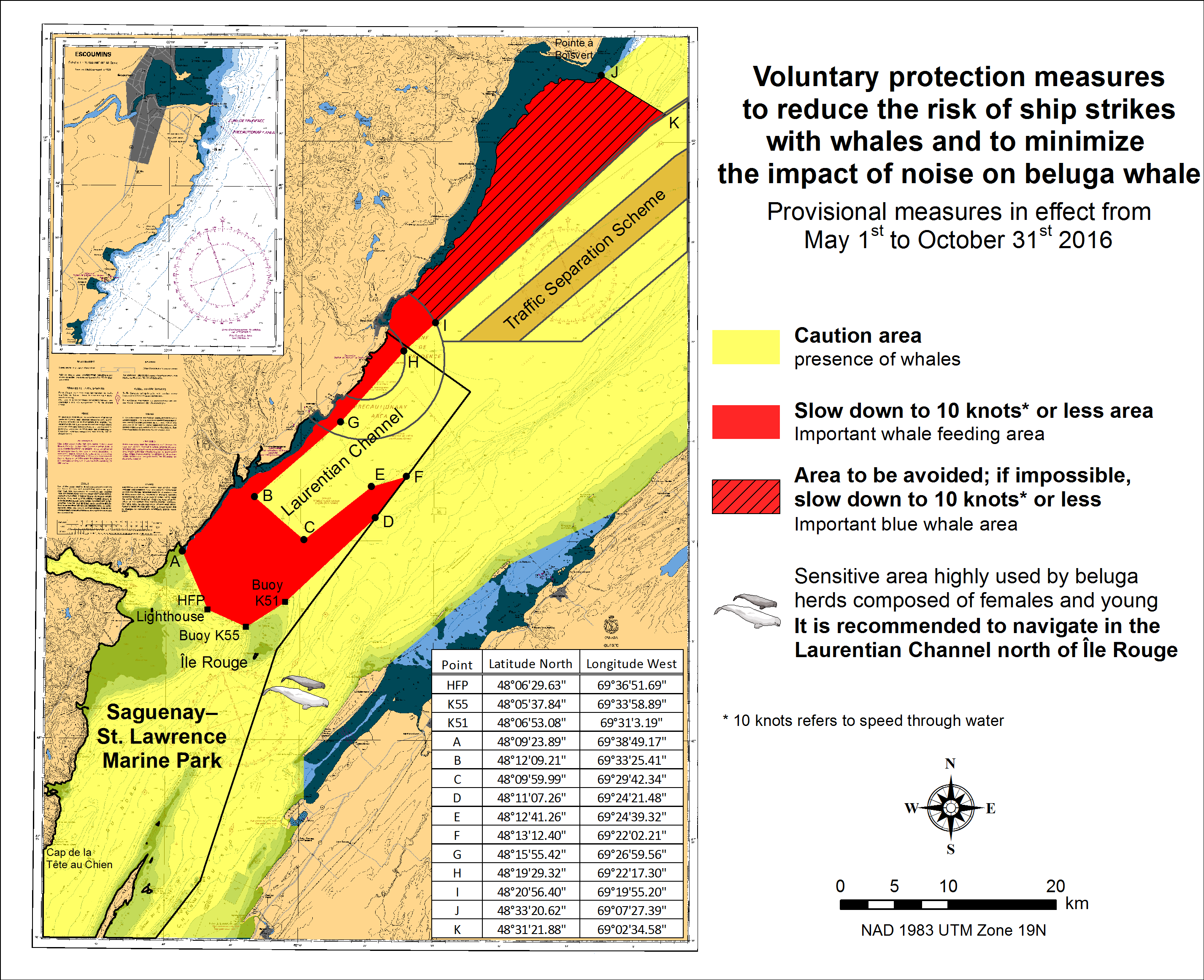
SAGUENAY-ST. LAWRENCE MARINE PARK AND SURROUNDING WATERS - WHALE PROTECTION.
The waters in and around the Saguenay-St. Lawrence Marine Park are well known for their resident threatened beluga population and the wide diversity of whales that migrate there to feed, particularly between April and November.
REGULATORY PROTECTION MEASURES
All whale species that are found in the St. Lawrence are protected under the Marine Mammal Regulations, pursuant to the Fisheries Act. Within the boundaries of the Marine Park, specific measures are set out in the Marine Activities in the Saguenay-St. Lawrence Marine Park Regulations, pursuant to the Act Establishing the Saguenay-St. Lawrence Marine Park. Any collision with a marine mammal within the Marine Park must immediately be reported to a park warden at 1-866-508-9888. For collisions that occur outside the Marine Park or for any situation involving a marine mammal that is dead or in trouble, contact the emergency network at 1-877-722-5346 or on channel 16.
For more information on the Saguenay-St. Lawrence Marine Park, see section 5C of the Annual Edition of the Notices to Mariners - April 2015 to March 2016.
VOLUNTARY PROTECTION MEASURES
Provisional measures in effect from May 1st to October 31st, 2016. See map below.
These measures apply to merchant vessels and cruise ships between Pointe à Boisvert and Cap de la Tête au Chien to prevent collisions with whales. These measures should only be taken when they will not jeopardize navigational safety.
Caution area (yellow area): To reduce the risk of collisions with whales that can be present anywhere in this area, heightened vigilance of navigators is critical. Posting a lookout is recommended in order to increase the chances of seeing the whales and thus taking necessary measures to avoid them. If bypassing the whales is not possible, slow down and wait for the animals to move away to a distance greater than 400 meters (0.215 nautical miles) before resuming original speed. It is more difficult to see the animals at night therefore increased caution is recommended.
Slow down to 10 knots or less area (red area): To reduce the risk of collisions with whales in this feeding area, it is recommended that vessels slow down to a maximum speed through the water of 10 knots and post a lookout. It is further recommended to remain in the Laurentian Channel to the north of Île Rouge to minimize the impact of noise in a sensitive area south of this island, which is highly frequented by herds of beluga whales composed of females and young.
Area to be avoided (hatched red area): To reduce noise and the risk of collisions with whales, vessels should avoid transiting through this area which is highly frequented by blue whales, an endangered species. If the area cannot be avoided, slow down to a speed through the water of 10 knots or less.
CANADIAN HYDROGRAPHIC SERVICE - ANNOUNCEMENT REGARDING TIDAL INFORMATION TABLES ON CHARTS.
*303(T) STRAIT OF CANSO - 2016 AND 2017, REDUCED OPERATIONAL SEASON AMENDMENT OF THE CONTACT PERSON.
Reference chart: 4302
Mariners are advised that, due to extensive maintenance requirements to the causeway swing bridge,
the Canso Canal will have a reduced operational season for the next two years. For the 2016 and 2017
navigation seasons, the Canso Canal will operate according to the following schedule:
2016 – April 14 to October 31
2017 – May 15 to December 24
For further information, please contact:
Ovide Boudreau
Officer-in-Charge
Canso Canal
Telephone: (902) 625-1973
Email: Ovide.Boudreau@dfo-mpo.gc.ca
*801 CANADIAN HYDROGRAPHIC SERVICE - NAUTICAL CHARTS
| CHARTS | MAIN TITLE | SCALE | PUBLISHED | CAT # | PRICE |
|---|---|---|---|---|---|
| New Charts | |||||
| 3978 | Bonilla Island to/à Edye Passage | 1:80000 | 01-JUL-2016 | ||
| New Editions | |||||
| 1514 | Carillon à/to Papineauville | 1:20000 | 22-APR-2016 | 3 | 18.00 |
| 1515 | Papineauville à/to Ottawa | 1:20000 | 29-APR-2016 | 3 | 18.00 |
| 2048 | Port Credit | 1:5000 | 29-APR-2016 | 3 | 12.00 |
| 5070 | Satosoak Island to/à Akuliakatak Peninsula | 1:25000 | 29-JAN-2016 | 1 | 20.00 |
| 6423 | Askew Islands to/à Bryan Island Kilometre 1180 / Kilometre 1240 | 1:50000 | 15-JAN-2016 | 4 | 12.00 |
| 7527 | Erebus and Terror Bay and/et Radstock Bay | 1:50000 | 29-APR-2016 | 4 | 20.00 |
| 7710 | Lambert Channel and/et Cache Point Channel | 1:80000 | 15-JUL-2016 | 4 | 20.00 |
| Charts Permanently Withdrawn | |||||
| 3927 | Bonilla Island to/à Edye Passage | ||||
*802 CANADIAN HYDROGRAPHIC SERVICE - ELECTRONIC NAVIGATIONAL CHARTS
| NEW PRODUCTS | |
|---|---|
| S-57 ENC NUMBER | CHART TITLE |
| CA376429 | Corbett Island to Ship Harbour Head |
| CA376616 | Garia Bay to/à Burgeo |
| CA473467 | Kangiqlugaapik (Erik Harbour) |
| CA576184 | Pugwash Harbour |
| CA576617 | La Poile |
| CA576618 | Grand Bruit Harbour |
| Retirées en permanence | |
| CA376429 | Corbett Island to Ship Harbour Head |
*803 CANADIAN HYDROGRAPHIC SERVICE – RASTER DIGITAL CHARTS (BSB V4).
| CHARTS | MAIN TITLE |
|---|---|
| Charts Permanently Withdrawb | |
| RM-1201 | Saint-Fulgence à/to Saguenay |
| RM-1203 | Tadoussac à/to Cap Éternité |
| RM-1223 | Chenal du Bic et les approches/and approaches |
| RM-1226 | Mouillages et Installations Portuaires/Anchorages and Harbour Installations - Haute Côte-Nord |
| RM-1233 | Cap aux Oies à/to Sault-au-Cochon |
| RM-1320 | Île du Bic au/to Cap de la Tête au Chien |
*804 TRANSPORT CANADA – SHIP SAFETY BULLETIN.
This is to notify you that a new Ship Safety Bulletin has recently been posted to
the Transport Canada website at:
www.tc.gc.ca/ssb-bsn/
To go online to view or download this bulletin, please click on the link below:
SSB#05/2016 – Zika Virus
RDIMS#11827410
Sign yourself up for e-Bulletin to receive an e-mail notice each time a new Ship Safety Bulletin
is published on our Web site
Contact us at: marinesafety-securitemaritime@tc.gc.ca
or 1-855-859-3123 (Toll Free).
*805 TRANSPORT CANADA – SHIP SAFETY BULLETIN.
This is to notify you that a new Ship Safety Bulletin has recently been posted to
the Transport Canada website at:
www.tc.gc.ca/ssb-bsn/
To go online to view or download this bulletin, please click on the link below:
SSB#06/2016 – Guidelines for Moored Attraction Vessels
RDIMS#11827410
Sign yourself up for e-Bulletin to receive an e-mail notice each time a new Ship Safety Bulletin
is published on our Web site
Contact us at: marinesafety-securitemaritime@tc.gc.ca
or 1-855-859-3123 (Toll Free).
*806 TRANSPORT CANADA – SHIP SAFETY BULLETIN.
This is to notify you that a new Ship Safety Bulletin has recently been posted to
the Transport Canada website at:
www.tc.gc.ca/ssb-bsn/
To go online to view or download this bulletin, please click on the link below:
SSB#07/2016 – Interim Measures for Small Marine Diesel Engines
RDIMS#11827410
Sign yourself up for e-Bulletin to receive an e-mail notice each time a new Ship Safety Bulletin
is published on our Web site
Contact us at: marinesafety-securitemaritime@tc.gc.ca
or 1-855-859-3123 (Toll Free).
*807 SAULT-AU-COCHON À/TO QUÉBEC – UNLIT SCIENTIFIC BUOYS DISCONTINUED.
Reference Chart: 1317
The following unlit scientific buoys have been discontinued:
Unlit scientific buoy SLA1 (LL 12521) (46° 52’ 03.7’’N 070° 59’ 03.1’’W)
Unlit scientific buoy SLA2 (LL 12522) (46° 51’ 52.2’’N 070° 58’ 59.9’’W)
Unlit scientific buoy SLA3 (LL 12523) (46° 51’ 13.3’’N 070° 58’ 48.0’’W)
Unlit scientific buoy SLA4 (LL 12524) (46° 50’ 58.9’’N 070° 58’ 44.4’’W)
Unlit scientific buoy SLA5 (LL 12525) (46° 50’ 46.7’’N 070° 58’ 40.8’’W)
Unlit scientific buoy ANGE1 (LL 12526) (46° 54’ 43.2’’N 071° 05’ 13.2’’W)
Unlit scientific buoy ANGE2 (LL 12527) (46° 54’ 34.9’’N 071° 05’ 04.9’’W)
Unlit scientific buoy ANGE3 (LL 12528) (46° 54’ 27.0’’N 071° 04’ 54.1’’W)
Unlit scientific buoy ANGE4 (LL 12529) (46° 54’ 16.9’’N 071° 04’ 45.5’’W)
(Q2016-092)
*808 LAC SAINT-PIERRE – UNLIT SCIENTIFIC BUOYS DISCONTINUED.
Reference Chart: 1312
The following unlit scientific buoys have been discontinued:
Unlit scientific buoy PSF1 (LL 12530) (46° 16’ 59.2’’N 072° 37’ 24.3’’W)
Unlit scientific buoy PSF2 (LL 12531) (46° 16’ 46.5’’N 072° 37’ 20.7’’W)
Unlit scientific buoy PSF3 (LL 12532) (46° 16’ 37.1’’N 072° 37’ 16.9’’W)
Unlit scientific buoy PSF4 (LL 12533) (46° 16’ 50.8’’N 072° 37’ 42.6’’W)
Unlit scientific buoy PSF5 (LL 12534) (46° 16’ 25.7’’N 072° 37’ 35.7’’W)
Unlit scientific buoy PSF6 (LL 12535) (46° 16’ 25.6’’N 072° 37’ 03.4’’W)
(Q2016-093)
*809 BATISCAN AU/TO LAC SAINT-PIERRE – PRIVATE UNLIT BUOYS ESTABLISHED.
Reference Chart: 1313
The following private unlit buoys have been established:
Buoy prohibited area #5 PRIV, Île Saint Quentin (LL 12793) (46° 21’ 06.8”N 072° 31’ 50.5”W)
Buoy prohibited area #4 PRIV, Île Saint Quentin (LL 12794) (46° 21’ 03.7”N 072° 31’ 48.3”W)
Buoy prohibited area #3 PRIV, Île Saint Quentin (LL 12795) (46° 21’ 01.6”N 072° 31’ 38.9”W)
Buoy prohibited area #2 PRIV, Île Saint Quentin (LL 12796) (46° 21’ 02.0”N 072° 31’ 33.2”W)
Buoy prohibited area #1 PRIV, Île Saint Quentin (LL 12797) (46° 21’ 03.4”N 072° 31’ 27.7”W)
(Q2016-078, 079, 080, 081, 082)
*810 BATISCAN AU/TO LAC SAINT-PIERRE – PRIVATE LIGHT BUOYS ESTABLISHED.
Reference Chart: 1313
The following private light buoys have been established:
Light buoy prohibited area C PRIV, Île Saint Quentin (LL 12800) (46° 21’ 06.0”N 072° 31’ 51.6”W)
Light buoy prohibited area A PRIV, Île Saint Quentin (LL 12802) (46° 21’ 02.2”N 072° 31’ 27.7”W)
(Q2016-086, 088)
*811 CAP DE LA TÊTE AU CHIEN AU/TO CAP AUX OIES – PRIVATE LIGHTS ESTABLISHED.
Reference Chart: 1234
The following private lights have been established:
The light Club nautique Pointe Rivière du Loup FR (LL 12803) (47° 50’ 48.4’’N 069° 34’ 07.4’’W)
The light Club nautique Pointe Rivière du Loup FR (LL 12804) (47° 50’ 48.7’’N 069° 34’ 08.3’’W)
The light Club nautique Pointe Rivière du Loup FR (LL 12805) (47° 50’ 50.3’’N 069° 34’ 09.8’’W)
(Q2016-089, 090, 091)
*812 SOREL-TRACY À/TO OTTERBURN-PARK – UNLIT BUOYS ESTABLISHED.
Reference Chart: 1350
The following unlit buoys have been established:
The unlit buoy Sorel-Tracy # 4 PRIV (LL 12766) (46° 01’ 43.3’’N 073° 07’ 55.2’’W)
The unlit buoy Saint-Charles-sur-Richelieu aval PRIV (LL 12822) (45° 41’ 34.1’’N 073° 11’ 27.2’’W)
(Q2016-026, 123)
*813 CAPE HURD TO/À TOBERMORY AND/ET COVE ISLAND - PORT FACILITY IS PERMANENTLY CLOSED.
Reference Chart: 2274
The Tobermory Public Port Dock Facilities (Old Ferry Dock) permanently closed to navigation due to
shallow water conditions, marked by 4 orange warning buoys. Inquiries are to be directed to Transport
Canada at 416-952-1027.
(NOTSHIP C624/10)
*814(T) MAIN DUCK ISLAND TO/À SCOTCH BONNET ISLAND – PARTIALLY SUBMERGED FIXED STEEL BARGES.
Reference Chart: 2060
There are 3 partially submerged fixed steel barges, in North end of West Lake (43° 57’ 02.3’’N 077° 20’ 12.8’’W)
which have been reported just below the water line.
Barges are marked with cautionary buoys.
(NOTSHIP C1641/14)
*815 TORONTO HARBOUR – ROCK REVETMENT CONSTRUCTED.
Reference Chart: 2085
Rock revetment has been constructed inside the breakwater west of Ontario place. The revetment is 460
metres in length and extends 6 to 8 metres from the north dock wall.
(NOTSHIP C58/15)
*816 CAPE HURD TO/À TOBERMORY AND/ET COVE ISLAND – UNCHARTED SUBMARINE CABLE HAS BEEN REPORTED.
Reference Chart: 2274
An uncharted submarine cable of 5 centimetres in diameter has been reported in approx.
position (45° 15' 54'’N 081° 40' 12’’W).
(NOTSHIP C2177/15)
*818(T) CAPE HURD TO/À LONELY ISLAND – LIGHT CHARACTERISTICS TEMPORARILY CHANGED.
Reference Chart: 2235
The light characteristics of Cove Island (LL 805) (U.S. LL 12675) has temporarily changed to flash
1 second, eclipse 9 seconds and night time operation only.
(NOTSHIP C2522/11)
*819(T) AUTOMATIC IDENTIFICATION SYSTEM (AIS).
AIS Application-Specific Messages (ASM) and AIS AtoN
Mariners are advised that the Canadian Coast Guard will perform a test of AIS Application-Specific Messages
(AIS-ASM) on the Pacific Coast from the Sand Heads meteorological/hydrological station: 49°06’21’’N 123°18’12’’W,
and may extend this testing to other stations in the coming months. The test will start at the end of August
and consist of broadcasting meteorological/hydrological (MET/HYDRO) data through AIS binary “Message 8”.
Although AIS was originally developed as a means for positive identification and tracking of ships,
it includes functionalities to transmit binary messages such as MET/HYDRO information and other types of
data. These additional functionalities of AIS may be useful to mariners to assist in onboard voyage planning.
Ships need to be equipped with a proper Class “A” AIS device for the accurate onboard display of AIS message.
The IMO mandatory carriage requirement for the Class “A” AIS display
Footnote 1.is the Minimum Keyboard Display (MKD) which displays the
binary data in an alphanumeric form. However, as there is no current requirement for the MKD to be capable
of decoding all AIS binary messages, the display and use of the ASM information may require additional
hardware and/or softwareFootnote 2.
AIS Aids to Navigation (AtoN)
The International Association of Marine Aids to Navigation and Lighthouse Authorities (IALA) defines an AtoN as:
'a device or system external to vessels that is designed and operated to enhance the safe and efficient
navigation of vessels and/or vessel traffic’Footnote 3.
The primary purpose of an AIS AtoN Station is to promote and enhance safety and efficiency of navigation
by one or more of the following:
- Providing a positive and all-weather means of identification;
- Complementing existing services (e.g. RACONS) from AtoN;
- Transmitting accurate positions of floating AtoN;
- Indicating if a floating AtoN is off position (monitoring the status of an AtoN);
- Marking or delineating tracks, routes, areas, and limits;
- Marking offshore structures;
- Enable timely marking of new hazards (fixed or dynamic) using Virtual AIS AtoN.
The use of AIS within the marine aids to navigation service is accomplished by the broadcasting of the aids to navigation report message “Message 21”.
An AIS AtoN can be implemented in three ways, Real, Synthetic, and Virtual.
- Physical/real AIS AtoN: : An AIS device which is physically located on the AtoN and transmits “Message 21”.
- Synthetic AIS AtoN: There are 2 types of Synthetic AIS AtoN – Monitored and Predicted.
- Monitored: A “Message 21” is transmitted from a nearby AIS base station. The AtoN physically exists but there is no AIS device on it. A communication link is installed on the AtoN to allow the monitoring of its status.
- Predicted : A “Message 21” is transmitted from a nearby AIS base station. The AtoN physically exists but there is neither an AIS device on it nor a communication link. Status and position of the AtoN cannot be monitored.
- Virtual AIS AtoN: :A “Message 21” is transmitted from a nearby AIS base station for an AtoN that does not physically exist. The “Message 21” will clearly identify this as a virtual AIS AtoN.
Displays and Symbology
As the AIS information available to mariners will be dependent on their display system, not all transmitted information may be displayed. Mariners are encouraged to install systems that provide AIS overlay on either ECDIS or Radar, or both.
Of those vessels that are AIS equipped the various displays available can range from no display on some Class B units, through to the mandatory Class A MKD, and to a full ECDIS or Radar overlay. In the absence of an ECDIS or Radar overlay, mariners will not be able to fully utilize the AIS AtoN functionality. Also note that there is a variance in the information that can be displayed on ECDIS or Radar equipment by the different AIS manufacturers.
The symbology that may be displayed on nautical charts, display systems and the MKD is summarised below.
Nautical Charts
On nautical charts AIS AtoN are indicated by a magenta circle surrounding the existing AtoN symbol and an adjacent legend stating AIS. The font will be straight for fixed AtoN and italic for floating AtoN.

A physical AIS AtoN provided as an overlay on ECDIS, Radar or other display systems are indicated by a diamond shape with crossed lines at the reported position of the AtoN. A physical AIS AtoN that is off position will use the same symbol but in red. A virtual AIS AtoN is indicated by a dotted line diamond shape with the crossed lines at the reported position.
| Physical AIS Aton | Physical AIS AtoN off position |
Virtual AIS AtoN |
|---|---|---|
 |
 |
 |
The mandatory MKD is only required to display data in alphanumeric form. Some MKD are units supplemented by a small graphical display. Exact presentation will vary but this layout below would be typical of MKD displays.
| Range | Bearing | Name |
|---|---|---|
| XX.XX | XXX.X | XXXXXXXXX |
| Latitude | XXX XX.XXX | |
| Longitude | XXX XX.XXX | |
Feedback on AIS - ASM
Mariners are requested to provide feedback on the AIS-ASM test bed to their applicable Regional MCTS Office.
Contact information can be found in the publication Radio Aids to Marine Navigation, Part 1.
*820(P) ANNAPOLIS BASIN – LIGHT TO BE DISCONTINUED.
Reference Chart: 4396
The Canadian Coast Guard proposes to permanently discontinue the following aid to navigation:
Broad Cove Wharf (LL 212) (44° 39’ 55.7’’N 065° 49’ 56.9’’W)
Comments on this action are solicited from mariners and other interested parties.
Comments should be directed to the following within three months from the date of this notice:
Superintendent, Renee Pope
Aids to Navigation,
Canadian Coast Guard,
P.O. Box 5667,
St. John’s, NL,
A1C 5X1
Telephone: (709) 772-2800
Email: renee.pope@dfo-mpo.gc.ca
Any objections raised must state the facts on which they are based and should include supporting information on safety, commerce and public benefit.
(F2016-036)
*821(P) ST. MARYS BAY – LIGHT TO BE DISCONTINUED.
Reference Chart: 4118
The Canadian Coast Guard proposes to permanently discontinue the following aid to navigation:
St. Marys Bay (LL 230.5) (44° 34’ 45.3’’N 065° 56’ 10.9’’W)
Comments on this action are solicited from mariners and other interested parties.
Comments should be directed to the following within three months from the date of this notice:
Superintendent, Renee Pope
Aids to Navigation,
Canadian Coast Guard,
P.O. Box 5667,
St. John’s, NL,
A1C 5X1
Telephone: (709) 772-2800
Email: renee.pope@dfo-mpo.gc.ca
Any objections raised must state the facts on which they are based and should include supporting information on safety, commerce and public benefit.
(F2016-038)
*822(P) STRAIT OF CANSO – LIGHT TO BE DISCONTINUED.
Reference Chart: 4302
The Canadian Coast Guard proposes to permanently discontinue the following aid to navigation:
North Canso W. side of N. entrance to Strait of Canso (LL 883.0) (45° 41’ 29.8”N 061° 29’ 18.1”W)
Comments on this action are solicited from mariners and other interested parties.
Comments should be directed to the following within three months from the date of this notice:
Superintendent, Renee Pope
Aids to Navigation,
Canadian Coast Guard,
P.O. Box 5667,
St. John’s, NL,
A1C 5X1
Telephone: (709) 772-2800
Email: renee.pope@dfo-mpo.gc.ca
Any objections raised must state the facts on which they are based and should include supporting information on safety, commerce and public benefit.
(G2016-119)
*823(P) PLANS, CONCEPTION BAY, TRINITY BAY AND/ET BONAVISTA HARBOUR – LIGHT TO BE DISCONTINUED.
Reference Chart: 4849
The Canadian Coast Guard proposes to permanently discontinue the following aid to navigation:
Squarry Island light (LL 446) (48° 39’ 06.1’’N 053° 07’ 42.6’’W)
Comments on this action are solicited from mariners and other interested parties.
Comments should be directed to the following within three months from the date of this notice:
Superintendent, Renee Pope
Aids to Navigation,
Canadian Coast Guard,
P.O. Box 5667,
St. John’s, NL,
A1C 5X1
Telephone: (709) 772-2800
Email: renee.pope@dfo-mpo.gc.ca
Any objections raised must state the facts on which they are based and should include supporting information on safety, commerce and public benefit.
(N2016-046)
*824 CAPE LAHAVE TO/À LIVERPOOL BAY – FOG SIGNAL PERMANENTLY DISCONTINUED.
Reference: Notice 1205(P)/15 is cancelled (Chart 4211).
(F2016-034)
*825 GUYON ISLAND TO/À FLINT ISLAND – FOG SIGNAL PERMANENTLY DISCONTINUED.
Reference: Notice 411(P)/15 is cancelled (Chart 4375).
(G2016-117)
SECTION 2 - CHART CORRECTIONS
1201 - Saint-Fulgence à/to Saguenay - New Chart - 07-FEB-2014 - NAD 1983
| 26-AUG-2016 | LNM/D. 13-FEB-2015 | ||
| Affix | patch | 48°24′16.0″N 070°56′55.0″W | |
| Download Patch - http://www.chs-shc.gc.ca/patches/PA1201_20160329.pdf | |||
| DFO(6409411-01) | |||
| Amend |
vertical clearance of 1 metre 2 decimetres, to read 1 metre 6 decimetres
(See Chart No. 1, D22) |
48°27′41.8″N 070°58′55.7″W | |
| This notice affects Electronic Navigational Chart: CA579237 | |||
| DFO(6409437-01) | |||
| Amend |
vertical clearance of 0 metres 2 decimetres, to read 0 metres 6 decimetres
(See Chart No. 1, D22) |
48°27′20.7″N 071°00′41.9″W | |
| This notice affects Electronic Navigational Chart: CA579237 | |||
| DFO(6409437-02) | |||
| Add |
vertical clearance 0 metres 3 decimetres
(See Chart No. 1, D22) |
48°25′47.6″N 071°02′00.6″W | |
| This notice affects Electronic Navigational Chart: CA579237 | |||
| DFO(6409437-03) | |||
| Amend |
vertical clearance of 7 metres 4 decimetres, to read 7 metres 8 decimetres
(See Chart No. 1, D22) |
48°25′55.2″N 071°04′13.0″W | |
| This notice affects Electronic Navigational Chart: CA579237 | |||
| DFO(6409437-04) | |||
| Amend |
vertical clearance of 2 metres 7 decimetres, to read 3 metres 1 decimetre
(See Chart No. 1, D22) |
48°25′54.8″N 071°04′06.6″W | |
| This notice affects Electronic Navigational Chart: CA579237 | |||
| DFO(6409437-05) | |||
| Amend |
vertical clearance of 2 metres 9 decimetres, to read 3 metres 4 decimetres
(See Chart No. 1, D22) |
48°25′46.5″N 071°04′32.7″W | |
| This notice affects Electronic Navigational Chart: CA579237 | |||
| DFO(6409437-06) | |||
1203 - Tadoussac à/to Cap Éternité - New Edition - 17-JUN-2011 - NAD 1983
| 19-AUG-2016 | LNM/D. 05-AUG-2016 | ||
| Affix | patch | Below the chart title block | |
| Download Patch -http://www.chs-shc.gc.ca/patches/PA1203_20160414.pdf | |||
| DFO(6409409-01) | |||
| 05-AUG-2016 | LNM/D. 13-MAY-2016 | ||
| Delete |
obstruction with known depth of 35 metres
(See Chart No. 1, K41) |
48°07′19.8″N 069°40′21.6″W | |
| This notice affects Electronic Navigational Chart: CA479053 | |||
| DFO(6409505-01) | |||
| Add |
subsurface Ocean Data Acquisition system (SADO/ODAS) with known depth of 33 metres (See Chart No. 1, L25) |
48°07′18.0″N 069°40′23.4″W | |
| This notice affects Electronic Navigational Chart: CA479053 | |||
| DFO(6409505-02) | |||
1223 - Chenal du Bic et les approches/and approaches - New Edition - 21-MAR-2008 - NAD 1983
| 19-AUG-2016 | |||
| Affix | patch | 48°18′58.0″N 068°43′53.0″W | |
| Download Patch - http://www.chs-shc.gc.ca/patches/PA1223_20160418.pdf | |||
| DFO(6409408-01) | |||
| Amend |
vertical clearance of 6 metres 5 decimetres, to read 6 metres 6 decimetres
(See Chart No. 1, D22) |
48°22′33.7″N 068°42′44.3″W | |
| This notice affects Electronic Navigational Chart: CA379232, CA479099 | |||
| DFO(6409436-01) | |||
1226 - Quai public/Public Wharf - New Edition - 19-FEB-2010 - NAD 1983
| 19-AUG-2016 | LNM/D. 05-FEB-2016 | ||
| Delete |
depth of 3 metres 6 decimetres
(See Chart No. 1, I10) |
49°13′59.3″N 068°07′59.8″W | |
| This notice affects Electronic Navigational Chart: CA579048 | |||
| DFO(6409512-01) | |||
| Add |
depth of 3 metres 2 decimetres
(See Chart No. 1, I10) |
49°13′59.3″N 068°07′59.7″W | |
| This notice affects Electronic Navigational Chart: CA579048 | |||
| DFO(6409512-02) | |||
1233 - Cap aux Oies à/to Sault-au-Cochon - New Edition - 11-MAY-2012 - NAD 1983
| 19-AUG-2016 | LNM/D. 05-AUG-2016 | ||
| Affix | patch | 47°18′38.0″N 070°40′30.0″W | |
| Download Patch -http://www.chs-shc.gc.ca/patches/PA1233-20160323.pdf | |||
| DFO(6409405-01) | |||
| Amend |
vertical clearance of 1 metre 5 decimetres to read 1 metre 7 decimetres
(See Chart No. 1, D22) |
47°25′59.7″N 070°01′10.7″W | |
| This notice affects Electronic Navigational Chart: CA479021 | |||
| DFO(6409421-01) | |||
1233 - Saint-Jean-Port-Joli - New Edition - 11-MAY-2012 - NAD 1983
| 19-AUG-2016 | LNM/D. 05-AUG-2016 | ||
| Delete |
private green port hand lighted pillar buoy Fl G, Priv
(See Chart No. 1, Qg) |
47°13′08.6″N 070°16′37.2″W | |
| This notice affects Electronic Navigational Chart: CA579024 | |||
| (Q2016094) LL(1875.1) DFO(6409482-01) | |||
| Delete |
private red starboard hand lighted spar buoy Fl R, Priv,
(See Chart No. 1, Qf) |
47°13′04.4″N 070°16′42.3″W | |
| This notice affects Electronic Navigational Chart: CA579024 | |||
| (Q2016095) LL(1875.2) DFO(6409483-01) | |||
1233 - Saint-Joseph-de-la-Rive - New Edition - 11-MAY-2012 - NAD 1983
| 05-AUG-2016 | LNM/D. 07-JUN-2013 | ||
| Delete |
depth of 4 metres 3 decimetres
(See Chart No. 1, I10) |
47°26′55.3″N 070°21′50.6″W | |
| This notice affects Electronic Navigational Chart: CA579022 | |||
| DFO(6409504-01) | |||
| Add |
depth of 3 metres 8 decimetres
(See Chart No. 1, I10) |
47°26′55.3″N 070°21′50.5″W | |
| This notice affects Electronic Navigational Chart: CA579022 | |||
| DFO(6409504-02) | |||
1234 - Cap de la Tête au Chien au/to Cap aux Oies - New Edition - 04-NOV-2011 - NAD 1983
| 26-AUG-2016 | LNM/D. 19-AUG-2016 | ||
| Affix | patch | 47°39′51.0″N 070°22′48.0″W | |
| Download Patch - http://www.chs-shc.gc.ca/patches/PA1234_20160323.pdf | |||
| DFO(6409406-02) | |||
| Amend |
vertical clearance of 2 metres 9 decimetres, to read 3 metres 3 decimetres
(See Chart No. 1, D22) |
47°39′25.3″N 070°09′29.4″W | |
| This notice affects Electronic Navigational Chart: CA379029 | |||
| DFO(6409432-01) | |||
| Delete |
Ru against pier
(See Chart No. 1, F33) |
47°50′46.9″N 069°34′14.6″W | |
| This notice affects Electronic Navigational Chart: CA379029 | |||
| DFO(6409503-01) | |||
1234 - Pointe de la Rivière du Loup - New Edition - 04-NOV-2011 - NAD 1983
| 19-AUG-2016 | LNM/D. 29-MAY-2015 | ||
| Affix | patch | 47°50′53.0″N 069°34′13.0″W | |
| Download Patch - http://www.chs-shc.gc.ca/patches/PA1234-20160707.pdf | |||
| This notice affects Electronic Navigational Chart: CA579031 | |||
| DFO(6409470-01) | |||
1236 - Matane - New Edition - 26-OCT-2012 - NAD 1983
| 12-AUG-2016 | LNM/D. 27-MAY-2016 | ||
| Delete |
depth of 6 metres 9 decimetres
(See Chart No. 1, I10) |
48°50′53.2″N 067°34′31.7″W | |
| This notice affects Electronic Navigational Chart: CA579040 | |||
| DFO(6409448-01) | |||
| Add |
depth of 6 metres 5 decimetres
(See Chart No. 1, I10) |
48°50′53.2″N 067°34′31.7″W | |
| This notice affects Electronic Navigational Chart: CA579040 | |||
| DFO(6409448-02) | |||
1236 - Pointe des Monts aux/to Escoumins - New Edition - 26-OCT-2012 - NAD 1983
| 12-AUG-2016 | LNM/D. 27-MAY-2016 | ||
| Amend |
vertical clearance of 2 metres 5 decimetres, to read 3 metres 1 decimetre
(See Chart No. 1, D22) |
48°38′30.0″N 069°06′38.0″W | |
| This notice affects Electronic Navigational Chart: CA279037 | |||
| DFO(6409438-01) | |||
| Amend |
vertical clearance of 5 metres 7 decimetres, to read 6 metres 0 decimetres
(See Chart No. 1, D22) |
48°38′05.0″N 069°06′15.0″W | |
| This notice affects Electronic Navigational Chart: CA279037 | |||
| DFO(6409438-02) | |||
| Delete |
private orange and white mooring can buoy
(See Chart No. 1, Q40) |
48°36′28.8″N 068°25′42.2″W | |
| This notice affects Electronic Navigational Chart: CA279037 | |||
| (Q2016076) DFO(6409445-01) | |||
| Add |
subsurface Ocean Data Acquisition system (SADO/ODAS) with known depth of 20 metres 0 decimetres (See Chart No. 1, L25) |
48°39′42.0″N 068°35′01.2″W | |
| This notice affects Electronic Navigational Chart: CA279037 | |||
| DFO(6409506-01) | |||
1310 - Section A-B - New Edition - 10-JAN-2014 - NAD 1983
| 12-AUG-2016 | LNM/D. 03-JUN-2016 | ||
| Add |
depth of 2 metres 8 decimetres
(See Chart No. 1, I10) |
45°42′15.4″N 073°29′02.1″W | |
| This notice affects Electronic Navigational Chart: CA579001 | |||
| DFO(6409473-05) | |||
| Add |
depth of 3 metres 7 decimetres
(See Chart No. 1, I10) |
45°42′16.3″N 073°28′57.2″W | |
| This notice affects Electronic Navigational Chart: CA579001 | |||
| DFO(6409473-06) | |||
1320 - Les Escoumins - New Chart - 26-AUG-2011 - NAD 1983
| 19-AUG-2016 | LNM/D. 12-AUG-2016 | ||
| Amend |
vertical clearance of 6 metres 8 decimetres, to read 6 metres 9 decimetres
(See Chart No. 1, D22) |
48°20′48.6″N 069°24′16.2″W | |
| This notice affects Electronic Navigational Chart: CA579233 | |||
| DFO(6409433-01) | |||
| Amend |
vertical clearance of 1 metre 3 decimetres, to read 1 metre 4 decimetres
(See Chart No. 1, D22) |
48°20′52.3″N 069°24′24.2″W | |
| This notice affects Electronic Navigational Chart: CA379232, CA579233 | |||
| DFO(6409433-02) | |||
1320 - Port de Gros-Cacouna - New Chart - 26-AUG-2011 - NAD 1983
| 12-AUG-2016 | LNM/D. 13-MAY-2016 | ||
| Add |
depth of 6 metres 9 decimetres
(See Chart No. 1, I10) |
47°55′54.9″N 069°30′55.6″W | |
| This notice affects Electronic Navigational Chart: CA579234 | |||
| DFO(6409468-01) | |||
| Delete |
depth of 7 metres 6 decimetres
(See Chart No. 1, I10) |
47°55′52.2″N 069°31′00.6″W | |
| This notice affects Electronic Navigational Chart: CA579234 | |||
| DFO(6409468-02) | |||
| Add |
depth of 7 metres 3 decimetres
(See Chart No. 1, I10) |
47°55′52.2″N 069°31′00.6″W | |
| This notice affects Electronic Navigational Chart: CA579234 | |||
| DFO(6409468-03) | |||
| Delete |
depth of 7 metres 7 decimetres
(See Chart No. 1, I10) |
47°55′49.8″N 069°30′57.2″W | |
| This notice affects Electronic Navigational Chart: CA579234 | |||
| DFO(6409468-04) | |||
| Add |
depth of 7 metres 3 decimetres
(See Chart No. 1, I10) |
47°55′49.8″N 069°30′57.1″W | |
| This notice affects Electronic Navigational Chart: CA579234 | |||
| DFO(6409468-05) | |||
| Add |
depth of 7 metres 4 decimetres
(See Chart No. 1, I10) |
47°55′47.8″N 069°31′04.9″W | |
| This notice affects Electronic Navigational Chart: CA579234 | |||
| DFO(6409468-06) | |||
| Add |
depth of 7 metres 5 decimetres
(See Chart No. 1, I10) |
47°55′46.7″N 069°31′09.7″W | |
| This notice affects Electronic Navigational Chart: CA579234 | |||
| DFO(6409468-07) | |||
| Delete |
depth of 7 metres 2 decimetres
(See Chart No. 1, I10) |
47°55′45.1″N 069°31′12.4″W | |
| This notice affects Electronic Navigational Chart: CA579234 | |||
| DFO(6409468-08) | |||
| Add |
depth of 6 metres 7 decimetres
(See Chart No. 1, I10) |
47°55′45.0″N 069°31′12.6″W | |
| This notice affects Electronic Navigational Chart: CA579234 | |||
| DFO(6409468-09) | |||
| Add |
depth of 6 metres 6 decimetres
(See Chart No. 1, I10) |
47°55′44.6″N 069°31′10.2″W | |
| This notice affects Electronic Navigational Chart: CA579234 | |||
| DFO(6409468-10) | |||
| Add |
depth of 7 metres 1 decimetre
(See Chart No. 1, I10) |
47°55′44.3″N 069°31′04.7″W | |
| This notice affects Electronic Navigational Chart: CA579234 | |||
| DFO(6409468-11) | |||
| Delete |
depth of 8 metres 1 decimetre
(See Chart No. 1, I10) |
47°55′43.6″N 069°30′56.9″W | |
| This notice affects Electronic Navigational Chart: CA579234 | |||
| DFO(6409468-12) | |||
| Add |
depth of 7 metres 7 decimetres
(See Chart No. 1, I10) |
47°55′43.6″N 069°30′56.8″W | |
| This notice affects Electronic Navigational Chart: CA579234 | |||
| DFO(6409468-13) | |||
| Delete |
depth of 9 metres 5 decimetres
(See Chart No. 1, I10) |
47°55′37.6″N 069°30′51.4″W | |
| This notice affects Electronic Navigational Chart: CA579234 | |||
| DFO(6409468-14) | |||
| Add |
depth of 9 metres 0 decimetres
(See Chart No. 1, I10) |
47°55′37.6″N 069°30′51.6″W | |
| This notice affects Electronic Navigational Chart: CA579234 | |||
| DFO(6409468-15) | |||
1320 - Île du Bic au/to Cap de la Tête au Chien - New Chart - 26-AUG-2011 - NAD 1983
| 19-AUG-2016 | LNM/D. 12-AUG-2016 | ||
| Affix | patch | 47°58′27.2″N 069°07′18.0″W | |
| Download Patch - http://www.chs-shc.gc.ca/patches/PA1320_20160323.pdf | |||
| DFO(6409407-01) | |||
| Amend |
vertical clearance of 6 metres 4 decimetres, to read 6 metres 6 decimetres
(See Chart No. 1, D22) |
48°22′36.4″N 068°42′49.3″W | |
| This notice affects Electronic Navigational Chart: CA379232, CA479099 | |||
| DFO(6409436-01) | |||
1430 - Lac Saint-Louis - New Chart - 16-APR-2010 - NAD 1983
| 05-AUG-2016 | LNM/D. 20-MAY-2016 | ||
| Amend |
green port hand lighted spar buoy Fl G, marked A25 with green port hand lighted pillar buoy Fl G, marked A25 (See Chart No. 1, Qg, Q23) |
45°23′10.7″N 073°48′10.6″W | |
| This notice affects Electronic Navigational Chart: CA479228 | |||
| (Q2016050) LL(19) DFO(6409375-01) | |||
1509 - Île Haynes - Sheet/Feuille 2 - New Edition - 19-APR-2013 - NAD 1983
| 12-AUG-2016 | LNM/D. 03-JUN-2016 | ||
| Add |
depth of 4 metres 5 decimetres
(See Chart No. 1, I10) |
45°42′13.7″N 073°29′19.0″W | |
| This notice affects Electronic Navigational Chart: CA579180 | |||
| DFO(6409473-01) | |||
| Add |
depth of 4 metres 5 decimetres
(See Chart No. 1, I10) |
45°42′13.6″N 073°29′15.4″W | |
| This notice affects Electronic Navigational Chart: CA579180 | |||
| DFO(6409473-02) | |||
| Add |
depth of 2 metres 4 decimetres
(See Chart No. 1, I10) |
45°42′11.4″N 073°29′17.2″W | |
| This notice affects Electronic Navigational Chart: CA579180 | |||
| DFO(6409473-03) | |||
| Add |
depth of 4 metres 0 decimetres
(See Chart No. 1, I10) |
45°42′13.4″N 073°29′10.7″W | |
| This notice affects Electronic Navigational Chart: CA579180 | |||
| DFO(6409473-04) | |||
| Add |
depth of 2 metres 8 decimetres
(See Chart No. 1, I10) |
45°42′15.4″N 073°29′02.1″W | |
| This notice affects Electronic Navigational Chart: CA579001 | |||
| DFO(6409473-05) | |||
| Add |
depth of 3 metres 7 decimetres
(See Chart No. 1, I10) |
45°42′16.3″N 073°28′57.2″W | |
| This notice affects Electronic Navigational Chart: CA579001 | |||
| DFO(6409473-06) | |||
| Delete |
depth of 3 metres 4 decimetres
(See Chart No. 1, I10) |
45°42′13.5″N 073°28′54.8″W | |
| This notice affects Electronic Navigational Chart: CA579001 | |||
| DFO(6409473-07) | |||
| Add |
depth of 2 metres 6 decimetres
(See Chart No. 1, I10) |
45°42′13.8″N 073°28′54.5″W | |
| This notice affects Electronic Navigational Chart: CA579001 | |||
| DFO(6409473-08) | |||
2067 - Hamilton Harbour - New Edition - 15-JUN-2007 - NAD 1983
| 05-AUG-2016 | LNM/D. 18-MAR-2016 | ||
| Add |
depth of 4.8 metres
(See Chart No. 1, I10) |
43°17′55.9″N 079°47′15.0″W | |
| This notice affects Electronic Navigational Chart: CA573362 | |||
| DFO(6604222-01) | |||
| Add |
depth of 6.3 metres
(See Chart No. 1, I10) |
43°17′58.5″N 079°47′10.6″W | |
| This notice affects Electronic Navigational Chart: CA573362 | |||
| DFO(6604222-02) | |||
2077 - Lake Ontario/Lac Ontario (Western Portion/Partie Ouest) - New Edition - 23-APR-1999 - NAD 1983
| 05-AUG-2016 | LNM/D. 17-JUL-2015 | ||
| Delete |
depth of 10.8
(See Chart No. 1, I10) |
43°22′09.0″N 079°42′30.0″W | |
| This notice affects Electronic Navigational Chart: CA373091 | |||
| DFO(6604218-01) | |||
| Add |
depth of 8.8m
(See Chart No. 1, I10) |
43°22′11.7″N 079°42′29.9″W | |
| This notice affects Electronic Navigational Chart: CA373091 | |||
| DFO(6604218-02) | |||
2086 - Toronto to/à Hamilton - Sheet/Feuille 1 - New Edition - 03-JAN-2003 - NAD 1983
| 05-AUG-2016 | LNM/D. 28-OCT-2011 | ||
| Delete |
depth of 10.8
(See Chart No. 1, I10) |
43°22′09.0″N 079°42′30.0″W | |
| This notice affects Electronic Navigational Chart: CA373091 | |||
| DFO(6604218-01) | |||
| Add |
depth of 8.8m
(See Chart No. 1, I10) |
43°22′11.7″N 079°42′29.9″W | |
| This notice affects Electronic Navigational Chart: CA373091 | |||
| DFO(6604218-02) | |||
| Add |
depth of 4.8 metres
(See Chart No. 1, I10) |
43°17′55.9″N 079°47′15.0″W | |
| This notice affects Electronic Navigational Chart: CA573362 | |||
| DFO(6604222-01) | |||
| Add |
depth of 6.3 metres
(See Chart No. 1, I10) |
43°17′58.5″N 079°47′10.6″W | |
| This notice affects Electronic Navigational Chart: CA573362 | |||
| DFO(6604222-02) | |||
4000 - Gulf of Maine to/à Baffin Bay / Baie de Baffin - New Edition - 25-JUL-2003 - NAD 1983
| 26-AUG-2016 | LNM/D. 19-AUG-2016 | ||
| Delete |
subsurface Ocean Data Acquisition system ODAS/SADO with known depth of 56 metres (See Chart No. 1, L25) |
48°59′24.0″N 051°02′06.0″W | |
| This notice affects Electronic Navigational Chart: CA176030, CA276092 | |||
| DFO(6307669-01) | |||
| 19-AUG-2016 | LNM/D. 01-JUL-2016 | ||
| Delete |
subsurface Ocean Data Acquisition system ODAS/SADO with known depth of 45 metres (See Chart No. 1, L25) |
50°16′42.0″N 051°50′42.0″W | |
| This notice affects Electronic Navigational Chart: CA176030 | |||
| DFO(6307641-02) | |||
| Delete |
subsurface Ocean Data Acquisition system ODAS/SADO with known depth of 60 metres (See Chart No. 1, L25) |
51°50′06.0″N 052°30′24.0″W | |
| This notice affects Electronic Navigational Chart: CA176030 | |||
| DFO(6307666-01) | |||
4001 - Gulf of Maine to Strait of Belle Isle /au Detroit de Belle Isle - New Edition - 01-DEC-1995 - NAD 1983
| 26-AUG-2016 | LNM/D. 19-AUG-2016 | ||
| Delete |
subsurface Ocean Data Acquisition system ODAS/SADO with known depth of 56 metres (See Chart No. 1, L25) |
48°59′24.0″N 051°02′06.0″W | |
| This notice affects Electronic Navigational Chart: CA176030, CA276092 | |||
| DFO(6307669-01) | |||
| 19-AUG-2016 | LNM/D. 01-JUL-2016 | ||
| Delete |
subsurface Ocean Data Acquisition system ODAS/SADO with known depth of 45 metres (See Chart No. 1, L25) |
50°16′42.0″N 051°50′42.0″W | |
| This notice affects Electronic Navigational Chart: CA176030 | |||
| DFO(6307641-02) | |||
| Delete |
subsurface Ocean Data Acquisition system ODAS/SADO with known depth of 60 metres (See Chart No. 1, L25) |
51°50′06.0″N 052°30′24.0″W | |
| This notice affects Electronic Navigational Chart: CA176030 | |||
| DFO(6307666-01) | |||
4002 - Golfe du Saint-Laurent / Gulf of St. Lawrence - New Edition - 30-OCT-2015 - NAD 1983
| 26-AUG-2016 | LNM/D. 17-JUN-2016 | ||
| Delete |
fog signal FogSig against light
(See Chart No. 1, R1, R20) |
45°45′57.3″N 060°06′45.7″W | |
| This notice affects Electronic Navigational Chart: CA179245, CA276204, CA376295 | |||
| (G2016117) LL(750) DFO(6307659-01) | |||
4003 - Cape Breton to/à Cape Cod - New Edition - 21-MAR-2003 - NAD 1983
| 12-AUG-2016 | LNM/D. 17-JUN-2016 | ||
| Replace |
depth of 80 fathoms by depth of 69 fathoms
(See Chart No. 1, I10) |
42°10′00.0″N 069°24′42.0″W | |
| (NGA:27/2016) DFO(6307650-02) | |||
4006 - Newfoundland and Labrador/Terre-Neuve-et-Labrador to Bermuda / aux Bermudes - New Edition - 08-AUG-2003 - NAD 1983
| 19-AUG-2016 | LNM/D. 29-APR-2016 | ||
| Delete |
subsurface Ocean Data Acquisition system ODAS/SADO with known depth of 60 metres (See Chart No. 1, L25) |
51°50′06.0″N 052°30′24.0″W | |
| This notice affects Electronic Navigational Chart: CA176030 | |||
| DFO(6307666-01) | |||
4012 - Yarmouth to/à Halifax - New Edition - 14-FEB-2003 - NAD 1983
| 05-AUG-2016 | LNM/D. 06-MAY-2016 | ||
| Delete |
legend FogSig against light
(See Chart No 1 R20) |
44°26′19.7″N 063°46′00.4″W | |
| This notice affects Electronic Navigational Chart: CA276801, CA476195 | |||
| (F2016032) LL(495) DFO(6307615-01) | |||
4013 - Halifax to/à Sydney - New Edition - 06-SEP-2002 - NAD 1983
| 26-AUG-2016 | LNM/D. 29-JUL-2016 | ||
| Delete |
fog signal Fog Sig against light
(See Chart No. 1, R1, R20) |
45°45′54.0″N 060°06′48.0″W | |
| This notice affects Electronic Navigational Chart: CA179245, CA276204, CA376295 | |||
| (G2016117) LL(750) DFO(6307659-01) | |||
4015 - Sydney to/à Saint-Pierre - New Edition - 28-MAR-2003 - NAD 1983
| 26-AUG-2016 | LNM/D. 17-JUN-2016 | ||
| Delete |
fog signal Fog Sig against light
(See Chart No. 1, R1, R20) |
45°45′57.0″N 060°06′45.0″W | |
| This notice affects Electronic Navigational Chart: CA179245, CA276204, CA376295 | |||
| (G2016117) LL(750) DFO(6307659-01) | |||
4017 - Cape Race to/à Cape Freels - New Edition - 07-MAR-2003 - NAD 1983
| 26-AUG-2016 | LNM/D. 05-FEB-2016 | ||
| Delete |
subsurface Ocean Data Acquisition system ODAS/SADO with known depth of 31 fathoms (See Chart No. 1, L25) |
48°59′24.0″N 051°02′06.0″W |
|
| This notice affects Electronic Navigational Chart: CA176030, CA276092 | |||
| DFO(6307669-01) | |||
4024 - Baie des Chaleurs/Chaleur Bay aux/to Îles de la Madeleine - New Edition - 06-MAR-2015 - NAD 1983
| 05-AUG-2016 | LNM/D. 17-JUN-2016 | ||
| Add |
subsurface Ocean Data Acquisition system (SADO/ODAS) with known depth of 20 metres 0 decimetres (See Chart No. 1, L25) |
47°46′27.0″N 064°02′04.8″W | |
| This notice affects Electronic Navigational Chart: CA279075 | |||
| DFO(6409469-01) | |||
4026 - Havre Saint-Pierre et/and Cap des Rosiers à/to Pointe des Monts - New Edition - 23-MAY-2014 - NAD 1983
| 05-AUG-2016 | LNM/D. 08-JUL-2016 | ||
| Add |
subsurface Ocean Data Acquisition system (SADO/ODAS) with known depth of 200 metres (See Chart No. 1, L25) |
49°32′35.4″N 065°46′19.2″W | |
| This notice affects Electronic Navigational Chart: CA279044 | |||
| DFO(6409469-02) | |||
4045 - Sable Island Bank/Banc de I'Île de Sable to/au St. Pierre Bank/Banc de Saint Pierre - New Edition - 10-OCT-2003 - NAD 1983
| 26-AUG-2016 | LNM/D. 17-JUN-2016 | ||
| Delete |
fog signal FogSig against light
(See Chart No. 1, R1, R20) |
45°45′57.0″N 060°06′45.0″W | |
| This notice affects Electronic Navigational Chart: CA179245, CA276204, CA376295 | |||
| (G2016117) LL(750) DFO(6307659-01) | |||
4211 - Cape Lahave to/à Liverpool Bay - New Edition - 20-JUN-2003 - NAD 1983
| 05-AUG-2016 | LNM/D. 21-SEP-2012 | ||
| Delete |
legend Fog Sig against light
(See Chart No. 1 R20) |
44°09′30.9″N 064°28′51.3″W | |
| This notice affects Electronic Navigational Chart: CA476664 | |||
| (F2016034) LL(417.5) DFO(6307628-01) | |||
4237 - Approaches to/Approches au Halifax Harbour - New Edition - 02-JUN-2000 - NAD 1983
| 05-AUG-2016 | LNM/D. 04-DEC-2015 | ||
| Affix | patch | 44°26′00.0″N 063°35′00.0″W | |
| Download Patch - http://www.chs-shc.gc.ca/patches/4237PA_20160628.pdf | |||
| This notice affects Electronic Navigational Chart: CA476009 | |||
| DFO(6307651-02) | |||
| Replace |
depth of 11 metres, 3 decimetres with depth of 1 metre, 9 decimetres
(See Chart No. 1, I10) |
44°26′25.9″N 063°31′49.1″W | |
| This notice affects Electronic Navigational Chart: CA476009 | |||
| DFO(6307651-04) | |||
4237 - Sambro Harbour - New Edition - 02-JUN-2000 - NAD 1983
| 05-AUG-2016 | LNM/D. 04-DEC-2015 | ||
| Affix | patch | 44°28′00.0″N 063°36′00.0″W | |
| Download Patch - http://www.chs-shc.gc.ca/patches/4237PA_20160609.pdf | |||
| This notice affects Electronic Navigational Chart: CA576010 | |||
| DFO(6307651-01) | |||
4320 - Egg Island to/à West ironbound Island - New Edition - 26-SEP-1997 - NAD 1983
| 05-AUG-2016 | LNM/D. 06-MAY-2016 | ||
| Delete |
legend FogSig 60s against light
(See Chart No. 1 R20) |
44°26′19.7″N 063°46′00.4″W | |
| This notice affects Electronic Navigational Chart: CA276801, CA476195 | |||
| (F2016032) LL(495) DFO(6307615-01) | |||
| Replace |
depth of 3 fathoms, 3 feet with depth of 2 fathoms, 4 feet
(See Chart No. 1, I10) |
44°15′28.6″N 064°20′08.6″W | |
| DFO(6307643-01) | |||
| Add |
depth of 1 fathom
(See Chart No. 1, I10) |
44°26′25.9″N 063°31′49.1″W | |
| DFO(6307651-06) | |||
4374 - Red Point to/à Guyon Island - New Edition - 08-NOV-2002 - NAD 1983
| 26-AUG-2016 | LNM/D. 22-JUL-2016 | ||
| Delete |
fog signal Fog Sig 60 s against light
(See Chart No. 1, R1, R20) |
45°46′00.0″N 060°06′46.0″W | |
| This notice affects Electronic Navigational Chart: CA179245, CA276204, CA376295 | |||
| (G2016117) LL(750) DFO(6307659-01) | |||
4375 - Guyon Island to/à Flint Island - New Edition - 11-OCT-2002 - NAD 1983
| 26-AUG-2016 | LNM/D. 22-JUL-2016 | ||
| Delete |
fog signal Fog Sig 60 s against light
(See Chart No. 1, R1, R20) |
45°46′00.0″N 060°06′46.5″W | |
| This notice affects Electronic Navigational Chart: CA179245, CA276204, CA376295 | |||
| (G2016117) LL(750) DFO(6307659-01) | |||
4381 - Chester Harbour - New Edition - 31-JAN-2003 - NAD 1983
| 26-AUG-2016 | LNM/D. 12-SEP-2014 | ||
| Add |
submarine cable
(See Chart No. 1, L30.1) |
joining 44°32′06.8″N 064°14′45.5″W
44°32′06.8″N 064°14′56.4″W and 44°31′59.8″N 064°15′06.7″W |
|
| This notice affects Electronic Navigational Chart: CA476199, CA576200 | |||
| DFO(6307660-01) | |||
| Add |
cable sign
(See Chart No. 1, Qv) |
44°32′07.2″N 064°14′56.6″W | |
| This notice affects Electronic Navigational Chart: CA576200 | |||
| DFO(6307660-02) | |||
4381 - Mahone Bay - New Edition - 31-JAN-2003 - NAD 1983
| 26-AUG-2016 | LNM/D. 12-SEP-2014 | ||
| Add |
submarine cable
(See Chart No. 1, L30.1) |
joining 44°32′06.8″N 064°14′45.5″W
44°32′06.8″N 064°14′56.4″W and 44°31′56.9″N 064°15′11.5″W |
|
| This notice affects Electronic Navigational Chart: CA476199, CA576200 | |||
| DFO(6307660-01) | |||
4384 - Pearl Island to/à Cape La Have - New Edition - 10-JAN-2003 - NAD 1983
| 05-AUG-2016 | LNM/D. 17-JUN-2016 | ||
| Delete |
legend Fog Sig against light
(See Chart No. 1 R20) |
44°09′31.9″N 064°28′50.7″W | |
| This notice affects Electronic Navigational Chart: CA476664 | |||
| (F2016034) LL(417.5) DFO(6307628-01) | |||
4385 - Chebucto Head to/à Betty Island - New Edition - 07-JUN-1996 - NAD 1983
| 05-AUG-2016 | LNM/D. 26-JUN-2015 | ||
| Delete |
legend FogSig 60s against light
(See Chart No. 1 R20) |
44°26′19.7″N 063°46′00.4″W | |
| This notice affects Electronic Navigational Chart: CA276801, CA476195 | |||
| (F2016032) LL(495) DFO(6307615-01) | |||
| Affix | patch | 44°26′00.0″N 063°35′00.0″W | |
| Download Patch - http://www.chs-shc.gc.ca/patches/4385PA_20160629.pdf | |||
| DFO(6307651-03) | |||
| Delete |
depth of 6 fathoms
(See Chart No. 1, I10) |
44°26′24.7″N 063°31′46.9″W | |
| DFO(6307651-05) | |||
| Add |
depth of 1 fathom
(See Chart No. 1, I10) |
44°26′25.9″N 063°31′49.1″W | |
| DFO(6307651-06) | |||
4386 - Head Harbour - New Edition - 16-JUL-2004 - NAD 1983
| 12-AUG-2016 | LNM/D. 05-AUG-2016 | ||
| Delete |
private red starboard hand conical buoy
(See Chart No. 1, Qf) |
44°40′00.4″N 063°54′27.6″W | |
| This notice affects Electronic Navigational Chart: CA476196 | |||
| DFO(6307644-05) | |||
4386 - St. Margaret's Bay - New Edition - 16-JUL-2004 - NAD 1983
| 12-AUG-2016 | LNM/D. 05-AUG-2016 | ||
| Delete |
private green port hand can buoy
(See Chart No. 1, Qg) |
44°40′27.2″N 063°54′03.7″W | |
| This notice affects Electronic Navigational Chart: CA476195 | |||
| DFO(6307644-01) | |||
| Delete |
private red starboard hand conical buoy
(See Chart No. 1, Qf) |
44°40′45.3″N 063°54′01.7″W | |
| This notice affects Electronic Navigational Chart: CA476195 | |||
| DFO(6307644-02) | |||
| Delete |
private red starboard hand conical buoy
(See Chart No. 1, Qf) |
44°40′33.3″N 063°54′29.6″W | |
| This notice affects Electronic Navigational Chart: CA476195 | |||
| DFO(6307644-03) | |||
| Delete |
private red starboard hand conical buoy
(See Chart No. 1, Qf) |
44°40′30.2″N 063°54′57.6″W | |
| This notice affects Electronic Navigational Chart: CA476195 | |||
| DFO(6307644-04) | |||
| Delete |
private red starboard hand conical buoy
(See Chart No. 1, Qf) |
44°40′00.4″N 063°54′28.0″W | |
| This notice affects Electronic Navigational Chart: CA476196 | |||
| DFO(6307644-05) | |||
| 05-AUG-2016 | LNM/D. 29-MAY-2015 | ||
| Delete |
legend FogSig against light
(See Chart No. 1 R20) |
44°26′19.7″N 063°46′00.4″W | |
| This notice affects Electronic Navigational Chart: CA276801, CA476195 | |||
| (F2016032) LL(495) DFO(6307615-01) | |||
4394 - LaHave River - West Ironbound Island to/à Riverport - New Edition - 26-JUL-2002 - NAD 1983
| 05-AUG-2016 | LNM/D. 17-JUN-2016 | ||
| Replace |
depth of 28 feet with depth of 19 feet
(See Chart No. 1, I10) |
44°15′40.2″N 064°21′08.0″W | |
| DFO(6307649-01) | |||
| Replace |
depth of 27 feet with depth of 16 feet
(See Chart No. 1, I10) |
44°15′41.1″N 064°21′11.6″W | |
| DFO(6307649-02) | |||
| Replace |
depth of 27 feet with depth of 13 feet
(See Chart No. 1, I10) |
44°15′42.5″N 064°21′18.1″W | |
| DFO(6307649-03) | |||
4403 - East Point to/à Cape Bear - New Edition - 04-APR-2003 - NAD 1983
| 12-AUG-2016 | LNM/D. 10-JUL-2015 | ||
| Add |
red starboard hand lighted spar buoy FlR, marked NH4
(See Chart No. 1, Qf) |
46°09′41.6″N 062°29′53.9″W | |
| This notice affects Electronic Navigational Chart: CA376248 | |||
| (G2016113) LL(953.4) DFO(6307648-01) | |||
4422 - Cardigan Bay - New Edition - 26-DEC-2003 - NAD 1983
| 12-AUG-2016 | LNM/D. 10-JUL-2015 | ||
| Add |
red starboard hand lighted spar buoy FlR, marked NH4
(See Chart No. 1, Qf) |
46°09′41.6″N 062°29′53.9″W | |
| This notice affects Electronic Navigational Chart: CA376248 | |||
| (G2016113) LL(953.4) DFO(6307648-01) | |||
4485 - Cap des Rosiers à/to Chandler - New Edition - 17-JUN-2011 - NAD 1983
| 05-AUG-2016 | LNM/D. 05-FEB-2016 | ||
| Add |
fish haven with depth of 5 metres 6 decimetres over an artificial feature
(See Chart No. 1, K46.2) |
48°28′44.2″N 064°17′00.5″W | |
| This notice affects Electronic Navigational Chart: CA379086 | |||
| DFO(6409447-01) | |||
| Add |
fish haven with depth of 5 metres 8 decimetres over an artificial feature
(See Chart No. 1, K46.2) |
48°22′17.7″N 064°34′34.3″W | |
| This notice affects Electronic Navigational Chart: CA379086 | |||
| DFO(6409447-02) | |||
| Delete |
depth of 3 metres 7 decimetres
(See Chart No. 1, I10) |
48°21′57.9″N 064°33′08.3″W | |
| This notice affects Electronic Navigational Chart: CA379086 | |||
| DFO(6409447-03) | |||
| Add |
fish haven with depth of 3 metres 7 decimetres over an artificial feature
(See Chart No. 1, K46.2) |
48°22′01.1″N 064°32′59.5″W | |
| This notice affects Electronic Navigational Chart: CA379086 | |||
| DFO(6409447-04) | |||
4728 - Epinette Point to/à Terrington Basin - New Edition - 22-NOV-2002 - NAD 1983
| 19-AUG-2016 | LNM/D. 23-SEP-2011 | ||
| Add |
sounding of 4 fathoms, 4 feet Rep (2016)
(See Chart No. 1, I3.2) |
53°23′00.0″N 060°11′00.0″W | |
| This notice affects Electronic Navigational Chart: CA476215 | |||
| DFO(6307663-01) | |||
| Add |
depth of 3 fathoms
(See Chart No. 1, I10) |
53°22′48.0″N 060°10′52.2″W | |
| This notice affects Electronic Navigational Chart: CA476215 | |||
| DFO(6307663-02) | |||
| Add |
depth of 1 fathom, 4 feet
(See Chart No. 1, I10) |
53°22′44.4″N 060°11′03.6″W | |
| This notice affects Electronic Navigational Chart: CA476215 | |||
| DFO(6307663-03) | |||
| Add |
depth of 1 fathom, 3 feet
(See Chart No. 1, I10) |
53°22′34.8″N 060°11′25.2″W | |
| This notice affects Electronic Navigational Chart: CA476215 | |||
| DFO(6307663-04) | |||
| Add |
depth of 2 fathoms, 2 feet
(See Chart No. 1, I10) |
53°22′30.0″N 060°11′54.0″W | |
| This notice affects Electronic Navigational Chart: CA476215 | |||
| DFO(6307663-05) | |||
| Add |
depth of 5 fathoms, 5 feet
(See Chart No. 1, I10) |
53°22′54.0″N 060°11′12.0″W | |
| This notice affects Electronic Navigational Chart: CA476215 | |||
| DFO(6307663-06) | |||
| Delete | note ″Channel Buoyed / Chenal balisé″ | 53°22′40.0″N 060°10′28.0″W | |
| This notice affects Electronic Navigational Chart: CA476215 | |||
| DFO(6307663-07) | |||
| Add |
green port hand lighted spar buoy Fl G, marked H21
(See Chart No. 1, Qg) |
53°22′49.7″N 060°11′00.6″W | |
| This notice affects Electronic Navigational Chart: CA476215 | |||
| (N2016038) LL(310.5) DFO(6307663-08) | |||
| Delete |
depth of 11 fathoms
(See Chart No. 1, I10) |
53°22′56.0″N 060°11′06.0″W | |
| This notice affects Electronic Navigational Chart: CA476215 | |||
| DFO(6307663-09) | |||
| Delete |
depth of 12 fathoms
(See Chart No. 1, I10) |
53°22′26.0″N 060°11′50.0″W | |
| This notice affects Electronic Navigational Chart: CA476215 | |||
| DFO(6307663-10) | |||
5001 - Labrador Sea/ Mer du Labrador - New Edition - 17-JAN-2003 - NAD 1983
| 19-AUG-2016 | LNM/D. 05-AUG-2016 | ||
| Delete |
subsurface Ocean Data Acquisition system ODAS/SADO with known depth of 60 metres (See Chart No. 1, L25) |
51°50′06.0″N 052°30′24.0″W | |
| This notice affects Electronic Navigational Chart: CA176030 | |||
| DFO(6307666-01) | |||
| 05-AUG-2016 | LNM/D. 05-FEB-2016 | ||
| Add |
subsurface Ocean Data Acquisition system ODAS/SADO
(See Chart No. 1, L25) |
56°49′19.3″N 052°13′08.7″W | |
| This notice affects Electronic Navigational Chart: CA176290 | |||
| DFO(6307639-01) | |||
5052 - Seniartlit Islands to/à Nain - New Edition - 30-DEC-2005 - NAD 1983
| 19-AUG-2016 | LNM/D. 08-MAY-2015 | ||
| Replace |
depth of 6 metres, 1 decimetre with depth of 5 metres, 5 decimetres
(See Chart No. 1, I10) |
56°27′11.8″N 061°33′54.4″W | |
| This notice affects Electronic Navigational Chart: CA376050 | |||
| DFO(6307661-01) | |||
8005 - Georges Bank - New Edition - 20-JUN-2003 - NAD 1983
| 12-AUG-2016 | LNM/D. 03-JUL-2015 | ||
| Replace |
depth of 80 fathoms with depth of 69 fathoms
(See Chart No. 1, I10) |
42°10′00.0″N 069°24′42.0″W | |
| (NGA:27/2016) DFO(6307650-02) | |||
8014 - Grand Banc/Grand Bank (Northeast Portion/Partie-nord-est) - New Edition - 25-JUL-2003 - NAD 1983
| 26-AUG-2016 | LNM/D. 05-FEB-2016 | ||
| Delete |
subsurface Ocean Data Acquisition system ODAS/SADO with known depth of 31 fathoms (See Chart No. 1, L25) |
48°59′24.0″N 051°02′06.0″W | |
| This notice affects Electronic Navigational Chart: CA176030, CA276092 | |||
| DFO(6307669-01) | |||
8015 - Funk Island and Approaches/et les approches - New Edition - 16-NOV-2001 - NAD 1983
| 19-AUG-2016 | LNM/D. 19-JUN-2015 | ||
| Delete |
subsurface Ocean Data Acquisition system ODAS/SADO with known depth of 45 metres (See Chart No. 1, L25) |
50°16′42.0″N 051°50′42.0″W | |
| This notice affects Electronic Navigational Chart: CA176030 | |||
| DFO(6307641-02) | |||
8049 - St. Michael Bay to/aux Gray Islands - New Edition - 07-MAR-2003 - Inconnu
| 19-AUG-2016 | LNM/D. 20-NOV-2015 | ||
| Delete |
subsurface Ocean Data Acquisition system ODAS/SADO with known depth of 60 metres (See Chart No. 1, L25) |
51°50′06.0″N 052°30′24.0″W | |
| This notice affects Electronic Navigational Chart: CA176030 | |||
| DFO(6307666-01) | |||
SECTION 3 - RADIO AIDS TO MARINE NAVIGATION CORRECTIONS
*826 RADIO AIDS TO MARINE NAVIGATION 2016, (ATLANTIC, ST. LAWRENCE, GREAT LAKES, LAKE WINNIPEG AND ARCTIC)
PART 2 - Page 25
REMOVE COMPLETELY
Placentia MCTS Centre VHF/DF Advisory Service:
A VHF/DF Advisory Service is available to vessels in difficulty within range of the Fortune Head VHF peripheral
site controlled from Placentia MCTS Centre. Bearing information to/from Fortune Head can be provided for use
at the discretion of the user.
PART 2 - Page 26
REMOVE THE FOLLOWING LINE
Table 2-9 - Placentia MCTS / VCP - Ship/Shore Communications
| Frequencies | ||||
|---|---|---|---|---|
| Sites located at | Channel | Transmit | Receive | Remarks |
| Fortune Head 47°04'02"N 055°50'52"W |
C16 C24 C70 |
VHF Direction Finding service is available. Ch24: Facilities are available for connecting ships directly to the commercial telephone system on shore. |
||
PART 2 - Page 43
ADD email address:
Email: safety.sarnia@innav.gc.ca
SECTION 4 - SAILING DIRECTIONS AND SMALL CRAFT GUIDE CORRECTIONS
ATL 104 — Cape North to Cape Canso (including Bras d’Or Lake), Second Edition, 2010 —
Chapter 3 — After paragraph 102
Insert: 102.1 The Ben Eoin Yacht Club and Marina is located on the east shore of East Bay, 1.7 miles
east of Cossitt Point. It is the largest marina on the Bras d’Or Lake, and there are 75 berths, including
seven visitor berths. The marina offers full services, with the exception of repair.
(A2016-004.8)
Chapter 3 — Adjacent to paragraph 102.1, add a marina pictograph.
(A2016-004.9)
ATL 106 — Gulf of Maine and Bay of Fundy, First Edition, 2001 —
Chapter 1 — Paragraph 5
Delete: Starboard hand
Replace by: Fairway
(A2016-006.10)
ATL 108 — Gulf of St. Lawrence (Southwest Portion), First Edition, 2006 —
Chapter 3 — Paragraph 245, after “north breakwater.”
Insert: A second light (1127.2) is shown from a mast having a port hand daymark,
on the outer end of the south breakwater.
(A2016-008.9)
Chapter 4 — In the vicinity of paragraph 216
Replace the SAINT-GODEFROI diagram with the new one provided in Section 4
of this Monthly Edition.
https://www.notmar.gc.ca/publications/monthly-mensuel/images/082016-east-est-sec4-saint-godefroi-atl108.pdf
(Q2016-041.1)
Chapter 4 — Delete paragraph 217
Replace by: 217 Depths from the dredged areas shown on the diagram are obtained from periodic dredgings.
Due to continuous silting, mariners should expect to find less water at some places. For the latest
information on depths, it is recommended to check with the appropriate local authority.
(Q2016-041.2)
ATL 110 — St. Lawrence River — Cap Whittle/Cap Gaspé to Les Escoumins and Anticosti Island, Third Edition, 2011 —
Chapter 3 — Paragraph 111, after “A fixed bridge with a vertical clearance of”
Delete: 2.5 m
Replace by: 3.1 m
(Q2016-024.1)
Chapter 3 — Paragraph 111, after “An overhead cable with a vertical clearance of”
Delete: 5.7 m
Replace by: 6 m
(Q2016-024.2)
Chapter 3 — Paragraph 181
Delete: “The diving site … seasonal buoys.”
(Q2016-034.1)
SECTION 5 - LIST OF LIGHTS, BUOYS AND FOG SIGNALS CORRECTIONS
Newfoundland
| No. | Name | Position ----- Latitude N. Longitude W. |
Light Characteristics |
Focal Height in m. above water |
Nominal Range |
Description ----- Height in meters above ground |
Remarks ----- Fog Signals |
|||
|---|---|---|---|---|---|---|---|---|---|---|
| 310.5 | Hamilton River SW – light buoy H21 |
53 22 49.7 060 11 00.6 |
Fl | G | 4s | ..... | ..... | Green spar marked "H21". |
Year round. Operates 24h. Chart:4728 Edn 08/16 (N16-038) |
|
| 470.72 | Old Perlican - Inner light buoy TP5 |
East coast. 48 05 20.1 053 00 48.0 |
Fl | G | 4s | ..... | ..... | Green spar marked "TP5" | Seasonal. Chart:4850 Edn 08/16 (N16-027) |
|
| 507.5 | Petty Harbour Shoal - light buoy MP2 |
47 27 52.8 052 42 04.8 |
Fl | R | 4s | ..... | ..... | Red spar, marked "MP2". | Seasonal. Chart: 4845 Edn 08/16 (N16-028) |
|
Atlantic
| No. | Name | Position ----- Latitude N. Longitude W. |
Light Characteristics |
Focal Height in m. above water |
Nominal Range |
Description ----- Height in meters above ground |
Remarks ----- Fog Signals |
|||
|---|---|---|---|---|---|---|---|---|---|---|
| 56 H4140 |
Stuart Town, breakwater | 45 01 11.8 066 56 06.5 |
Fl | W | 4s | 5.6 | 6 | Square skeleton tower, red rectangular daymark with white band. | Flash 1s; eclipse 3s. Year round. Chart: 4124 Edn 08/16 (F16-043) |
|
| 417.5 H3718 |
Cherry Cove | On point of land between Little Harbour and Back Cove. 44 09 29.8 064 28 53.2 |
Iso | G | 4s | 6.7 | 8 | Cylindrical mast.
3.7 |
Year round. Chart: 4211 Edn 08/16 (F16-034) |
|
| 495 H3652 |
Betty Island | On Brig point. 44 26 19.7 063 46 00.4 |
LFl | W | 15s | 19.2 | 13 | Square skeleton tower, white rectangular daymark with red bands. | Flash 4s; eclipse 11s. Visible from all points of marine approach from the S. Year round. Chart : 4385 Edn 08/16 (F16-032) |
|
| 741.03 | L’Archevêque - light buoy NH4 | 45 37 16.0 060 34 26.3 |
Fl | R | 4s | ..... | ..... | Red spar, marked "NH4". | Seasonal. (In place year round). Chart:4374 Edn 08/16 (G16-118) |
|
| 750 H3360 |
Guyon Island | On island. 45 45 57.3 060 06 45.7 |
Fl | W | 20s | 16.2 | 17 | White octagonal tower, red upper portion. 12.8 |
Flash 1s; eclipse 19s. Emergency light. Year round. Chart:4375 Edn 08/16 (G16-117) |
|
| 874.31 | Inverness – Inner light buoy VL1 | 46 13 38.9 061 19 17.7 |
Q | G | 1s | ..... | ..... | Green sparmarked "VL1". | Operates 24h. Seasonal. Chart:4463 Edn 08/16 (G16-116) |
|
| 953.4 | Cardigan Shoal - light buoy NH4 | 46 09 41.6 062 29 53.9 |
Fl | R | 4s | ..... | ..... | Red spar, marked "NH4". | Seasonal. (In place year round). Operates 24h. Chart:4422 Edn 08/16 (G16-113) |
|
| 1060.57 | New London - light buoy JN3 | 46 30 24.5 063 28 43.8 |
Fl | G | 4s | ..... | ..... | Green spar marked "JN3". | Buoy may be repositioned due to shifting channel. Seasonal Chart:N/A Edn 08/16 (G16-115) |
|
| 1060.6 | Southwest River - light buoy JN4 | 46 30 24.9 063 28 16.2 |
Q | R | 1s | ..... | ..... | Red spar, marked "JN4". | Buoy may be repositioned due to shifting channel. Seasonal. Chart:N/A Edn 08/16 (G16-114) |
|
| 1248.15 | Shippegan Gully - light buoy TJ8 | Delete from list. Chart : N/A Edn 08/16 (G16-106) |
||||||||
| 1248.51 | Shippegan Gully – light buoy TJ9 | 47 42 58.1 064 39 44.8 |
Fl | G | 4s | ..... | ..... | Green spar marked "TJ9". | Operates 24h. Seasonal. Chart:N/A Edn 08/16 (G16-107) |
|
| 1248.7 | Shippegan South Gully - light buoy TJ10 | Delete from list. Chart: 4913 Edn 08/16 |
||||||||
| 1248.71 | Shippegan South Gully - light buoy TJ12 | 47 43 09.4 064 40 01.6 |
Fl | R | 4s | ..... | ..... | Red, marked "TJ12". | Seasonal. Chart:N/A Edn 08/16 (G16-109) |
|
| 1249.1 | Shipegan Gully – light buoy TJ10 | 47 43 03.0 064 39 53.6 |
Q | R | 1s | ..... | ..... | Red spar, marked "TJ10". | Seasonal.
Chart: N/A Edn 08/16 (G16-108) |
|
| 1250.5 H1531 |
Shippegan Gully, breakwater | Outer end of W. breakwater. 47 43 04.6 064 39 57.8 |
Fl | W | 4s | 4.5 | 6 | Cylindrical mast, green, white and black square daymark. | Flash 1s; eclipse 3s. Seasonal. Chart: 4920 Edn 08/16 (G16-110) |
|
| 1273.5 H1564.2 |
Shippegan Island, West Wharf | On NW corner of wharf. 47 53 00.2 064 34 32.0 |
Iso | G | 2s | 4.2 | 5 | Pipe swing pole, green, white and black square daymark. | Seasonal. Chart: 4913 Edn 08/16 (G16-111) |
|
| 1657.5 | ODAS light buoy IML-8 | Delete from list. Chart: 4026 Edn 08/16 (Q16-017) |
||||||||
| 1875.1 | Marina Saint-Jean-Port-Joli - light buoy PRIV | Delete from list. Chart: 1233 Edn 08/16 (Q16-094) |
||||||||
| 1875.2 | Marina Saint-Jean-Port-Joli - light buoy PRIV | Delete from list. Chart: 1233 Edn 08/16 (Q16-095) |
||||||||
Inland Waters
| No. | Name | Position ----- Latitude N. Longitude W. |
Light Characteristics |
Focal Height in m. above water |
Nominal Range |
Description ----- Height in meters above ground |
Remarks ----- Fog Signals |
|||
|---|---|---|---|---|---|---|---|---|---|---|
| 19 | Light buoy A25 | 45 23 10.7 073 48 10.6 |
Fl | G | 4s | ..... | ..... | Green, marked "A25". | Seasonal. (Winter spar). Chart:1430 Edn 08/16 (Q16-050) |
|
| 1635.92 | Wade Point Reef - light buoy KE2 | 52 14 55.8 099 54 24.9 |
Fl | R | 4s | ..... | ..... | Red spar, marked "KE2". | Seasonal. Chart: 6272 Edn 08/16 (A16-007) |
|
CANADIAN COAST GUARD - MARINE INFORMATION REPORT AND SUGGESTION SHEET
Name of Ship or Sender:..................................................................... Date:....................................
Address of Sender:..........................................................................................................................
Street # Street Name
Town / City:.............................. Prov / State:....................... Postal Code / Zip Code: ........................
Tel / Fax / E-mail address of sender (if appropriate):............................................................................
Observation Date:............................................. Time (UTC): ...........................................................
Geographical Position:......................................................................................................................
Coordinate Position: Lat: ............................................... Long:.........................................................
Position Method: DGPS GPS with WAAS GPS Radar Other
Horizontal Datum Used: WGS 84 NAD 27 Other
Estimated Position Accuracy:............................................................................................................
Chart #:............................................................ Datum: NAD 27 NAD 83
Chart Edition:.................................................... Last Correction applied:............................................
Publications affected: (Quote edition and page number):.....................................................................
*Full details (Attach additional sheets as necessary):...........................................................................
Mariners are requested to notify the responsible authorities when new or suspected dangers to navigation are discovered, changes are observed in aids to navigation, or corrections to publications are seen to be necessary.
In the case of new or suspected dangers to navigation, it is important that all details be given in order to aid with future investigations. Items of interest include heights, depths, physical description, type of bottom and equipment method used to position the item. It is helpful to mark details on the chart, which will be promptly replaced by the Canadian Hydrographic Service.
Reports should be made to the nearest Marine Communications and Traffic Services Centre (MCTS) and should be confirmed in writing to:
Leader, Notices to Mariners
Canadian Coast Guard
Department of Fisheries and Oceans
Montréal, QC H2Y 2E7
In the case of information concerning aids to navigation or the List of Lights, Buoys and Fog Signals book.
OR
Director General, Canadian Hydrographic Service & Oceanographic Services
Department of Fisheries and Oceans
Ottawa, ON K1A 0E6
In the case of new or suspected dangers to navigation or where corrections to "Sailing Directions" appear to be necessary.
For general questions on Canadian Coast Guard programs or services, please send an e-mail to:
info@dfo-mpo.gc.ca (Please include your postal code and e-mail address).
You can access the online form on the following page: https://www.notmar.gc.ca/incident-en.php or you can use the printable pdf version : https://www.notmar.gc.ca/publications/monthly-mensuel/images/monthly-form-en.pdf