
Archived information
The Standard on Web Usability replaces this content. This content is archived because Common Look and Feel 2.0 Standards have been rescinded.
Archived information is provided for reference, research or recordkeeping purposes. It is not subject to the Government of Canada Web Standards and has not been altered or updated since it was archived.
NOTICES TO MARINERS
PUBLICATION
EASTERN EDITION

Safety First, Service Always
Published Monthly by the
CANADIAN COAST GUARD
www.notmar.gc.ca/subscribe/
CONTENTS
| Section 1 | General and Safety Information |
| Section 2 | Chart Corrections |
| Section 3 | Radio Aids to Marine Navigation Corrections |
| Section 4 | Sailing Directions and Small Craft Guide Corrections |
| Section 5 | List of Lights, Buoys and Fog Signals Corrections |
Canadian Coast Guard Programs
Aids to Navigation and Waterways
Fisheries and Oceans Canada
Montreal, Quebec
H2Y 2E7
© Her Majesty the Queen in Right of Canada, 2017
DFO/2017-2002
Fs152-6E-PDF
ISSN 1719-7708
Disponible en français :
Publication des Avis aux navigateurs
Édition de l'Est
Édition mensuelle Nº05/2017
Fisheries and Oceans Canada
Official Publication of the Canadian Coast Guard
DFO/2018-2002
EXPLANATORY NOTES
Geographical positions refer directly to the graduations of the largest scale Canadian Hydrographic chart unless otherwise indicated.
Bearings refer to the true compass and are measured clockwise from 000° (North) clockwise to 359°; those relating to lights are from seaward.
Visibility of lights is that in clear weather.
Depths - The units used for soundings (metres, fathoms or feet) are stated in the title of each chart.
Elevations are normally given above Higher High Water, Large Tide unless otherwise indicated.
Distances may be calculated as follows:
1 nautical mile = 1,852 metres (6,076.1 feet)
1 statute mile = 1,609.3 metres (5,280 feet)
1 metre = 3.28 feet
Temporary & Preliminary Notices are indicated by a (T) or a (P) in Section 1, respectively. Please note that Nautical charts are not amended by the Canadian Hydrographic Service for Temporary (T) and Preliminary (P) Notices. It is recommended that mariners chart these corrections in pencil. The list of charts affected by Temporary and Preliminary Notices are revised and promulgated quarterly in Section 1 of the Monthly Edition.
Please note that, in addition to the temporary and preliminary changes normally advertised as (T) and (P) Notices, there are a few permanent changes to aids to navigation that have been advertised as Preliminary Notices to Mariners while charts are being updated for new editions.
Marine Information Report & Suggestion Sheet
Mariners are requested to notify the responsible authorities when new or suspected dangers to navigation are discovered, changes observed in aids to navigation or corrections to publications are seen
to be necessary. Such communications can be made using the Marine Information Report & Suggestion Sheet inserted on the last
page of each monthly edition of Notices to Mariners.
Canadian Hydrographic Service - Information Published in Section 2 of Notices to Mariners
Mariners are advised that only the most critical changes that directly affect safety to navigation are issued in Section 2 – Chart Corrections. This limitation
is required to ensure that charts remain as clear and easy to read as possible. As a result, mariners may see minor discrepancies of a
non-critical nature between information in official publications. For example, a small change in the nominal range or focal height of a light
may not result in the production of a chart correction in Notices to Mariners, but may result in a correction in the List of Lights, Buoys and
Fog Signals publication.
In case of discrepancy between information provided on CHS charts relating to aids to navigation, and the List of Lights, Buoys and Fog Signals publication, the latter shall be deemed as containing the most up-to-date information.
Canadian Nautical Charts & Publications
A source list of Canadian nautical charts and publications is published in Notice No. 14 of the Notices to Mariners Annual Edition 2018. The source supply and the prices
effective at the time of printing are listed. For current chart edition dates, please refer to the following website:
www.chs-shc.gc.ca/charts-cartes/paper-papier/index-eng.asp
CHART CORRECTIONS - SECTION 2
Corrections to nautical charts will be listed in numerical order by chart number. Each chart correction listed applies only to that particular chart. Related charts, if any, will have their own specific correction listed separately.
Users should also refer to CHS Chart 1: Symbols, Abbreviations and Terms for additional information pertaining to the correction of charts.
The illustration below describes the elements that will comprise a typical Section 2 chart correction:

The last correction number is identified with the LNM/D or Last Notice to Mariners Number / Date.
NOTICES TO MARINERS WEBSITE – MONTHLY EDITIONS, CHART CORRECTIONS, AND CHART PATCHES
The Notices to Mariners website allows users to access the monthly publications,
chart corrections, and chart patches.
Users can subscribe for free to the email notification service
to receive notifications when charts of interest are updated, including their patches, as well as when a new monthly edition becomes available online.
ADVISORY NOTICES TO SHIPPING (BROADCAST AND WRITTEN)
The Canadian Coast Guard is implementing a number of changes to the aids to navigation system in Canada.
These changes are advertised as Notices to Shipping (Broadcast and Written) by the Canadian Coast Guard, and are then followed up with Notices to Mariners, then charts are updated by hand correction, reprints or new editions.
Mariners are advised that all relevant Written Notices to Shipping should be kept until superseded by Notices to Mariners or through revised charts issued by the Canadian Hydrographic Service (CHS).
Written Notices to Shipping are available on the Canadian Coast Guard website at: www.ccg-gcc.gc.ca/eng/CCG/NOTSHIP.
The Canadian Hydrographic Service is reviewing the impact of these changes with the Canadian Coast Guard and together are preparing an action plan on the issuing of chart revisions.
For further information, contact your local Regional Notices to Shipping (NOTSHIP) issuing authorities.
Newfoundland
* Port aux Basques MCTS Centre
Canadian Coast Guard
49 Stadium Rd.
P.O. Box 99
Port aux Basques, NL A0M 1C0
Telephone: (709) 695-2168 or 1-800-563-9089
Facsimile: (709) 695-7784
Email: notshippax@dfo-mpo.gc.ca
Website: http://www.ccg-gcc.gc.ca/eng/CCG/Notship#nfld
Central & Arctic
* Prescott MCTS Centre
Canadian Coast Guard
401 King Street West
P.O. Box 1000
Prescott, ON K0E 1T0
“C” Series NOTSHIPs
Telephone: (613) 925-0666
Facsimile: (613) 925-4519
Email: CA.XCA-NotshipDesk@dfo-mpo.gc.ca
Website: http://www.ccg-gcc.gc.ca/eng/CCG/Notship-Home
Maritimes
* Sydney MCTS Centre
Canadian Coast Guard
1190 Westmount Road
Sydney, NS B1R 2J6
Telephone: (902) 564-7751 or 1-800-686-8676
Facsimile: (902) 564-7662
Email: notshipssyd@mar.dfo-mpo.gc.ca
Website: http://www.ccg-gcc.gc.ca/eng/CCG/Notship#maritime
Québec
* Les Escoumins MCTS Centre
Canadian Coast Guard
35, rue Otis
Les Escoumins, QC G0T 1K0
Telephone: (418) 233-2308
Facsimile: (418) 233-3299
Email: opsavis@dfo-mpo.gc.ca
Website: www.marinfo.gc.ca/en/avisecrits/index.asp
* Iqaluit MCTS Centre
Operational from approximately mid-May until late December.
Canadian Coast Guard
P.O. Box 189
Iqaluit, NU X0A 0H0
“A” Series NOTSHIPs
Telephone: (867) 979-5269
Facsimile: (867) 979-4264
Email: IqaNordreg@innav.gc.ca
Website: http://www.ccg-gcc.gc.ca/eng/CCG/Notship-Home
“H” Series NOTSHIPs
Telephone: (867) 979-0310
Facsimile: (867) 979-4264
Email: Iqamck01@innav.gc.ca
Website: http://www.ccg-gcc.gc.ca/eng/CCG/Notship-Home
* Service available in English and French.
Index
NUMERICAL INDEX OF CANADIAN CHARTS AFFECTED
| 1311 | 4002 | 4474 | 7071 |
| 1351 | 4003 | 4486 | 7194 |
| 1436 | 4010 | 4821 | 7302 |
| 1438 | 4049 | 4847 | 7404 |
| 1439 | 4116 | 4849 | 7513 |
| 1512 | 4117 | 4864 | 7565 |
| 1515 | 4203 | 4956 | 7608 |
| 2205 | 4243 | 5002 | 7930 |
| 2207 | 4244 | 5003 | 7954 |
| 2297 | 4376 | 5032 | 8006 |
| 2298 | 4472 | 7052 | 8011 |
| 4001 | 4473 | 7053 | 8012 |
SECTION 1 - GENERAL AND SAFETY INFORMATION
CANADIAN HYDROGRAPHIC SERVICE - ANNOUNCEMENT REGARDING CANADIAN HYDROGRAPHIC SERVICE CHART PATCHES
Colour Web Patches are free to the mariner, and given the quality of many printers, should reproduce well. They will be available in real time all around the world.
CHS welcomes your feedback on this service at chsinfo@dfo-mpo.gc.ca.
CANADIAN HYDROGRAPHIC SERVICE - CUMULATIVE CHART CORRECTIONS
The cumulative Notices to Mariners corrections for charts can now be accessed at https://www.notmar.gc.ca/corrections-en.php.
CANADIAN HYDROGRAPHIC SERVICE - CURRENT CHART EDITION DATES
CHART EDITIONS
The three terms described below are used to indicate the publication status of Canadian charts.
NEW CHART - "NEWCHT"
The first publication of a Canadian chart embracing an area not previously charted to the scale shown, or embracing an area different from any existing Canadian chart.
NEW EDITION - "NEWEDT"
A new issue of an existing chart containing amendments essential to navigation in addition to those issued in Notices to Mariners and making existing editions obsolete.
REPRINTS
A new issue of the current edition of a chart incorporating no amendments of navigational significance other than those previously promulgated in Notices to Mariners. It may also contain amendments from other sources provided they are not essential to navigation. Previous printings of the current edition remain in force.
The current chart edition dates can be accessed at www.chs-shc.gc.ca/charts-cartes/paper-papier/index-eng.asp
CANADIAN HYDROGRAPHIC SERVICE - PRINT ON DEMAND CHARTS - CARE AND USE
Background
By providing nautical charts to the public, the goal of the Canadian Hydrographic Service (CHS) is to provide services for safe navigation in a fiscally responsible manner. As a result, CHS continues to expand its portfolio of nautical paper charts that are printed using Print On Demand (POD) technology. These charts are easily recognized by their whiter paper and the coloured logo of the Canadian Hydrographic Service. This new technology enables CHS to print charts in a more efficient manner, while enhancing chart content through being able to quickly add new and important information. POD technology provides customers with up-to-date charts without the historical hand-drawn corrections or glued-on patches. Additionally, this technology eliminates out-of-stock situations which arise with the traditional printing and warehousing methods. In the event of a national emergency, CHS can respond to the appropriate authorities with the best available information very quickly.
Care of Your POD Chart
CHS encourages its customers to handle the POD charts more carefully than the traditional lithographic charts. When plotting information on POD charts, use HB pencils and apply limited pressure. Testing has suggested that an Indian gum eraser is more effective than alternatives when used on the product. This eraser is also suitable for charts printed using lithographic processes.
CANADIAN HYDROGRAPHIC SERVICE, TRANSPORT CANADA - NAVIGATION SAFETY - ECDIS
Mariners are advised that ECDIS may not display some isolated shoal depths when operating in "base or standard display" mode. Route planning and monitoring alarms for these shoal depths may not always be activated. To ensure safe navigation and to confirm that a planned route is clear of such dangers, mariners should visually inspect the planned route and any deviations from it using ECDIS configured to display "all data". The automated voyage planning check function should not be solely relied upon.
TRANSPORT CANADA - RESTRICTED SPEED AREA - ST. CLAIR AND DETROIT RIVERS
Since November 14, 2012 the restricted speed area currently in place as per the St. Clair and Detroit River Navigation Safety Regulation between the Detroit River light and Peche Island light is reduced in size by relocating the southern point of the restricted speed area from its current location at the Detroit River light to a new location at Bar Point light D33. (This notice refers to the previous one published in November 2012 with number *1103)
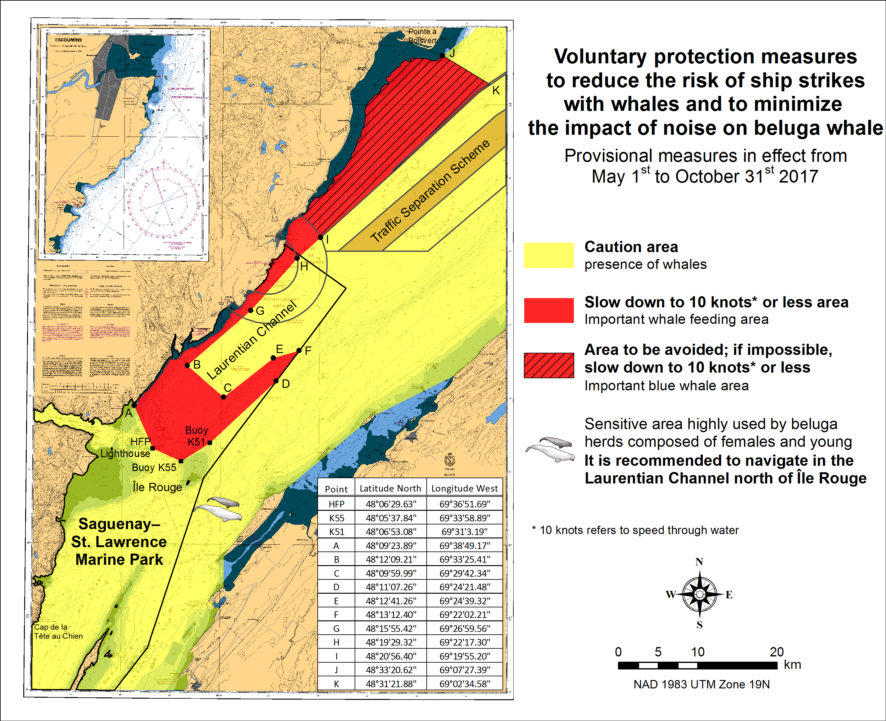
SAGUENAY-ST. LAWRENCE MARINE PARK AND SURROUNDING WATERS – WHALE PROTECTION
The waters in and around the Saguenay–St. Lawrence Marine Park are well known for the resident endangered beluga population and the wide diversity of whales that migrate there to feed,
particularly between April and November
REGULATORY PROTECTION MEASURES
All whale species that are found in the St. Lawrence are protected under the Marine Mammal Regulations, pursuant to the Fisheries Act. Within the boundaries of the Marine Park,
specific measures are set out in the Marine Activities in the Saguenay–St. Lawrence Marine Park Regulations, pursuant to the Act Establishing the Saguenay–St. Lawrence Marine Park.
Any collision with a marine mammal within the Marine Park must immediately be reported to a park warden at 1-866-508-9888. For collisions that occur outside the Marine Park or for
any situation involving a marine mammal that is dead or in trouble, contact the emergency network at 1-877-722-5346 or on channel 16.
For more information on the Saguenay–St. Lawrence Marine Park, see section 5C of the Notices to Mariners Annual Edition 2017.
VOLUNTARY PROTECTION MEASURES
Provisional measures in effect from May 1st to October 31st, 2017. See map below.
These measures apply to merchant vessels and cruise ships between Pointe à Boisvert and Cap de la Tête au Chien to prevent collisions with whales. These measures should only be taken when they will
not jeopardize navigational safety.
Caution area (yellow area): To reduce the risk of collisions with whales that can be present anywhere in this area, heightened vigilance of navigators is critical.
Posting a lookout is recommended in order to increase the chances of seeing the whales and thus taking necessary measures to avoid them. If bypassing the whales is not possible,
slow down and wait for the animals to move away to a distance greater than 400 meters (0.215 nautical miles) before resuming original speed. It is more difficult to see the animals
at night therefore increased caution is recommended.
Slow down to 10 knots or less area (red area): To reduce the risk of collisions with whales in this feeding area, it is recommended that vessels slow down to a maximum
speed through the water of 10 knots and post a lookout. It is further recommended to remain in the Laurentian Channel to the north of Île Rouge to minimize the impact of noise in a
sensitive area south of this island, which is highly frequented by herds of beluga whales composed of females and young.
Area to be avoided (hatched red area): To reduce noise and the risk of collisions with whales, vessels should avoid transiting through this area which is highly frequented
by blue whales, an endangered species. If the area cannot be avoided, slow down to a speed through the water of 10 knots or less.
*501 CANADIAN HYDROGRAPHIC SERVICE – NAUTICAL CHARTS
| CHARTS | MAIN TITLE | SCALE | PUBLISHED | CAT # | PRICE |
|---|---|---|---|---|---|
| New Charts | |||||
| 7513 | Milne Inlet, Southern Portion / Partie Sud | 1:40 000 | 27-JAN-2017 | 4 | 20.00 |
| New Editions | |||||
| 1436 | Whaleback Shoal to/au Summerland Group | 1:25 000 | 17-MAR-2017 | 3 | 20.00 |
| 2297 | Duck Islands to\à DeTour Passage | 1:91 085 | 25-MAR-2016 | 3 | 20.00 |
| 2298 | Cove Island to/aux Duck Islands | 1:91 010 | 25-MAR-2016 | 3 | 20.00 |
| 5002 | Hudson Strait and Bay/Baie et Détroit D'Hudson | 1:3 500 000 | 29-MAY-2015 | 1,4 | 20.00 |
| 5003 | Hudson Bay (Southern Portion) and James Bay/Baie D'Hudson (Partie Sud) et Baie James | 1:1 000 000 | 29-MAY-2015 | 4 | 20.00 |
| 7071 | Cape Norton Shaw to/à Cape M'Clintock | 1:500000 | 25-MAR-2016 | 4 | 20.00 |
| 7194 | Cape Hooper to/à Arguyartu Point Including/y compris Ekalugad Fiord | 1:125 000 | 25-MAR-2016 | 4 | 20.00 |
| 7302 | Lady Ann Strait to/à Smith Sound | 1:500 000 | 25-MAR-2016 | 4 | 20.00 |
| 7404 | Frozen Strait, Lyon Inlet and Approaches/et les Approches | 1:200 000 | 25-MAR-2016 | 4 | 20.00 |
| 7608 | Eskimo Lakes | 1:150 000 | 25-MAR-2016 | 4 | 20.00 |
| 7930 | Hell Gate and/et Cardigan Strait | 1:75 000 | 25-MAR-2016 | 4 | 20.00 |
| 7954 | Cape Stallworthy to/à Cape Discovery | 1:500 000 | 25-MAR-2016 | 4 | 20.00 |
*502 CANADIAN HYDROGRAPHIC SERVICE – MODIFICATIONS TO THE 2017 CANADIAN TIDE AND CURRENT TABLES – VOLUME 3
Mariners should replace the following values for Baie-Trinité, Index no. 2815 published in the 2017 Canadian Tide and Current Tables with the attached table for
Baie-Trinité on page 64, Volume 3, 2017 Canadian Tide and Current Tables, St. Lawrence River and Saguenay Fjord.
The Canadian Hydrographic Service of the Quebec Region has recently been informed that there is an error in the 2017 Canadian Tide and Current Tables,
Volume 3, St. Lawrence River and Saguenay Fjord, page 64, Index no. 2815 – BAIE-TRINITÉ.
Mariners and users are advised that tidal prediction calculations for the secondary port of Baie-Trinité should be carried out on the reference port of
SEPT-ÎLES rather than of Pointe-au-Père. The information and tidal differences for secondary port BAIE-TRINITÉ should be located in the block of stations on SEPT-ÎLES.
The tidal predictions of times and heights of the high and low tides on the website for Baie-Trinité are however correct.
Insert the new part of Table 3 provided in Section 1 of this monthly edition.
https://www.notmar.gc.ca/publications/monthly-mensuel/images/ed052017-part1-tidal-information.pdf
SECTION 2 - CHART CORRECTIONS
1311 - Sorel-Tracy à/to Varennes - New Edition - 19-SEP-2013 - NAD 1983
| 12-MAY-2017 | LNM/D. 10-MAR-2017 | ||
| Delete | crib with elevation of 5 metres (See Chart No. 1, Fb) This notice affects Electronic Navigational Chart: CA479155 |
45°57′28.1″N 073°13′02.9″W | |
| DFO(6409650-01) |
1351 - Pointe à la Meule à/to Pointe Naylor - Sheet/Feuille 3 - New Edition - 18-NOV-2016 - NAD 1983
| 26-MAY-2017 | |||
| Delete | water intake (See Chart No. 1, L41.1) This notice affects Electronic Navigational Chart: CA579126 |
between 45°08′05.1″N 073°15′06.6″W and 45°08′05.2″N 073°15′11.8″W |
|
| DFO(6409634-01) | |||
| Add | potable water intake, PWI (See Chart No. 1, Lb) This notice affects Electronic Navigational Chart: CA579126 |
joining 45°08′12.8″N 073°15′08.1″W 45°08′08.0″N 073°15′11.2″W and 45°08′05.2″N 073°15′11.8″W |
|
| DFO(6409634-02) |
1438 - Grindstone Island to/à Carleton Island - New Edition - 31-AUG-2012 - World Geodetic System 1984
| 26-MAY-2017 | LNM/D. 10-MAY-2013 | ||
| Delete | depth of 3.0 metres (See Chart No. 1, I10) This notice affects Electronic Navigational Chart: CA473025 |
44°09′09.6″N 076°20′17.1″W | |
| DFO(6604290-01) | |||
| Add | sounding of 0.2 metres, Rep (2017) (See Chart No. 1, I10) This notice affects Electronic Navigational Chart: CA473025 |
44°09′09.1″N 076°20′15.7″W | |
| DFO(6604290-02) | |||
| Add | sounding of 0.1 metres, Rep (2017) (See Chart No. 1, I10) This notice affects Electronic Navigational Chart: CA473025 |
44°09′19.4″N 076°20′12.5″W | |
| DFO(6604290-03) |
1439 - Carleton Island to/au Charity Shoal - New Edition - 08-DEC-2000 - NAD 1983
| 26-MAY-2017 | LNM/D. 03-MAR-2017 | ||
| Delete | depth of 3.0 metres (See Chart No. 1, I10) This notice affects Electronic Navigational Chart: CA473025 |
44°09′09.6″N 076°20′17.1″W | |
| DFO(6604290-01) | |||
| Add | sounding of 0.2 metres, Rep (2017) (See Chart No. 1, I10) This notice affects Electronic Navigational Chart: CA473025 |
44°09′09.1″N 076°20′15.7″W | |
| DFO(6604290-02) | |||
| Add | sounding of 0.1 metres, Rep (2017) (See Chart No. 1, I10) This notice affects Electronic Navigational Chart: CA473025 |
44°09′19.4″N 076°20′12.5″W | |
| DFO(6604290-03) |
1512 - Ottawa to/à Long Island - Sheet/Feuille 1 - New Edition - 04-MAR-2005 - NAD 1983
| 19-MAY-2017 | LNM/D. 06-MAR-2015 | ||
| Amend | vertical clearance of 51 feet to read 44 feet (See Chart No. 1, D22) This notice affects Electronic Navigational Chart: CA579160 |
45°25′47.9″N 075°42′20.6″W | |
| DFO(6604283-01) |
1515 - Becketts Creek à/to Ottawa - Sheet/Feuille 2 - New Edition - 29-APR-2016 - NAD 1983
| 19-MAY-2017 | LNM/D. 16-DEC-2016 | ||
| Amend | vertical clearance of 15 metres to read 13 metres (See Chart No. 1, D22) This notice affects Electronic Navigational Chart: CA579160 |
45°25′50.0″N 075°42′27.9″W | |
| DFO(6604283-01) |
1515 - Hull - Ottawa CONTINUATION A - Sheet/Feuille 2 - New Edition - 29-APR-2016 - NAD 1983
| 19-MAY-2017 | LNM/D. 16-DEC-2016 | ||
| Amend | vertical clearance of 15 metres to read 13 metres (See Chart No. 1, D22) This notice affects Electronic Navigational Chart: CA579160 |
45°25′44.7″N 075°42′27.3″W | |
| DFO(6604283-01) |
2205 - Killarney to/à Little Current - Sheet/Feuille 1 - New Edition - 09-JUL-2010 - NAD 1983
| 19-MAY-2017 | LNM/D. 26-SEPT-2014 | ||
| Add | submarine power cable (See Chart No. 1, L31.1) This notice affects Electronic Navigational Chart: CA473229, CA573307 |
joining 45°58′35.0″N 081°54′11.8″W 45°58′37.6″N 081°54′09.9″W 45°58′39.4″N 081°54′10.4″W and 45°58′50.1″N 081°54′09.5″W |
|
| DFO(6604265-01) |
2207 - Little Current (2207-4) - Sheet/Feuille 2 - New Chart - 27-JUL-2001 - NAD 1983
| 19-MAY-2017 | LNM/D. 30-SEP-2016 | ||
| Add | submarine power cable (See Chart No. 1, L31.1) This notice affects Electronic Navigational Chart: CA473229, CA573307 |
joining 45°58′35.0″N 081°54′11.8″W 45°58′37.6″N 081°54′09.9″W 45°58′39.4″N 081°54′10.4″W and 45°58′50.1″N 081°54′09.5″W |
|
| DFO(6604265-01) |
4001 - Gulf of Maine to Strait of Belle Isle / au Detroit de Belle Isle - New Edition - 01-DEC-1995 - NAD 1983
| 05-MAY-2017 | LNM/D. 02-DEC-2016 | ||
| Add | private yellow ODAS/SADO lighted pillar FlY, Priv (See Chart No. 1, Q58) This notice affects Electronic Navigational Chart: CA176030, CA276101 |
46°31′51.4″N 048°32′33.5″W | |
| DFO(6307915-01) |
4002 - Golfe du Saint-Laurent / Gulf of St. Lawrence - New Edition - 30-OCT-2015 - NAD 1983
| 12-MAY-2017 | LNM/D. 31-MAR-2017 | ||
| Delete | submarine cable area (See Chart No. 1, L30.2) This notice affects Electronic Navigational Chart: CA179245 |
joining 46°07′58.1″N 063°46′14.4″W 46°09′08.5″N 063°43′51.3″W 46°12′28.9″N 063°40′23.3″W and 46°14′20.3″N 063°39′33.9″W |
|
| DFO(6409653-01) | |||
| Delete | submarine cable area (See Chart No. 1, L30.2) This notice affects Electronic Navigational Chart: CA179245 |
between 46°08′03.7″N 063°47′23.2″W and 46°14′30.3″N 063°39′50.6″W |
|
| DFO(6409653-02) | |||
| Add | submarine cable area (See Chart No. 1, L30.2) This notice affects Electronic Navigational Chart: CA179245 |
between 46°06′09.0″N 063°46′20.7″W and 46°12′56.1″N 063°37′13.9″W |
|
| DFO(6409653-03) | |||
| Add | submarine cable area (See Chart No. 1, L30.2) This notice affects Electronic Navigational Chart: CA179245 |
between 46°08′04.3″N 063°47′25.6″W and 46°14′40.5″N 063°42′01.4″W |
|
| DFO(6409653-04) |
4003 - Cape Breton to / à Cape Cod - New Edition - 21-MAR-2003 - NAD 1983
| 19-MAY-2017 | LNM/D. 03-FEB-2017 | ||
| Delete | yellow ODAS/SADO lighted pillar Fl (5) Y (See Chart No. 1, Q58) This notice affects Electronic Navigational Chart: CA176140 |
42°10′38.5″N 063°35′57.4″W | |
| DFO(6307871-01) | |||
| Delete | yellow ODAS/SADO lighted pillar Fl (5) Y (See Chart No. 1, Q58) This notice affects Electronic Navigational Chart: CA176140 |
42°24′58.8″N 062°13′06.6″W | |
| DFO(6307871-02) | |||
| Add | wellhead with legend (Aband) (See Chart No. 1, L20) This notice affects Electronic Navigational Chart: CA176140 |
42°26′38.0″N 062°14′54.0″W | |
| DFO(6307871-03) | |||
| Add | wellhead with legend (Aband) (See Chart No. 1, L20) This notice affects Electronic Navigational Chart: CA176140 |
42°12′16.0″N 063°37′30.0″W | |
| DFO(6307871-04) |
4010 - Bay of Fundy / Baie de Fundy: Inner portion / partie intérieure - New Edition - 14-FEB-2003 - NAD 1983
| 19-MAY-2017 | LNM/D. 10-MAR-2017 | ||
| Delete | private yellow ODAS/SADO lighted pillar Fl (5) Y20s, Priv (See Chart No. 1, Q58) This notice affects Electronic Navigational Chart: CA376011, CA576005 |
45°11′50.9″N 066°05′53.8″W | |
| DFO(6307895-01) | |||
| Reposition | private yellow ODAS/SADO lighted pillar Fl (5) Y20s, Priv (See Chart No. 1, Q58) |
from 45°12′30.0″N 066°05′45.0″W to 45°11′49.1″N 066°06′50.2″W |
|
| (F2017012) LL(98.8) DFO(6307895-02) |
4049 - Grand Bank, Northern Portion / Grand Banc, Partie Nord to / à Flemish Pass / Passe Flamande - New Edition - 19-MAY-1995 - NAD 1983
| 05-MAY-2017 | LNM/D. 14-APR-2017 | ||
| Add | private yellow ODAS/SADO lighted pillar FlY, Priv (See Chart No. 1, Q58) This notice affects Electronic Navigational Chart: CA176030, CA276101 |
46°31′51.4″N 048°32′33.5″W | |
| DFO(6307915-01) |
4116 - Approaches to / Approches à Saint John - New Edition - 31-AUG-2007 - NAD 1983
| 19-MAY-2017 | LNM/D. 01-JUL-2016 | ||
| Delete | private yellow ODAS/SADO lighted pillar Fl (5) Y20s, Priv (See Chart No. 1, Q58) This notice affects Electronic Navigational Chart: CA376011, CA576005 |
45°11′50.9″N 066°05′53.8″W | |
| DFO(6307895-01) | |||
| Delete | private yellow ODAS/SADO lighted pillar Fl (5) Y20s, Priv (See Chart No. 1, Q58) This notice affects Electronic Navigational Chart: CA376011, CA576005 |
45°12′30.0″N 066°05′45.0″W | |
| LL(98.8) DFO(6307895-03) | |||
| Add | private yellow ODAS/SADO lighted pillar Fl (5) Y20s, Priv (See Chart No. 1, Q58) This notice affects Electronic Navigational Chart: CA376011, CA576005 |
45°11′49.1″N 066°06′50.2″W | |
| LL(98.8) DFO(6307895-04) |
4117 - Saint John Harbour and Approaches / et les approches - New Edition - 29-MAY-2009 - NAD 1983
| 19-MAY-2017 | LNM/D. 01-JUL-2016 | ||
| Delete | private yellow ODAS/SADO lighted pillar Fl (5) Y20s, Priv (See Chart No. 1, Q58) This notice affects Electronic Navigational Chart: CA376011, CA576005 |
45°11′50.9″N 066°05′53.8″W | |
| DFO(6307895-01) | |||
| Delete | private yellow ODAS/SADO lighted pillar Fl (5) Y20s, Priv (See Chart No. 1, Q58) This notice affects Electronic Navigational Chart: CA376011, CA576005 |
45°12′30.0″N 066°05′45.0″W | |
| LL(98.8) DFO(6307895-03) | |||
| Add | private yellow ODAS/SADO lighted pillar Fl (5) Y20s, Priv (See Chart No. 1, Q58) This notice affects Electronic Navigational Chart: CA376011, CA576005 |
45°11′49.1″N 066°06′50.2″W | |
| LL(98.8) DFO(6307895-04) |
4203 - Halifax Harbour: Black Point to / à Point Pleasant - New Edition - 14-APR-2000 - NAD 1983
| 26-MAY-2017 | LNM/D. 28-APR-2017 | ||
| Add | On certain copies anchoring prohibited symbol (See Chart No. 1, N20) This notice affects Electronic Navigational Chart: CA576002 |
44°36′24.6″N 063°32′31.2″W | |
| DFO(6307932-02) |
4243 - Tusket Islands to / à Cape St Marys - New Edition - 11-OCT-2002 - NAD 1983
| 12-MAY-2017 | LNM/D. 23-DEC-2016 | ||
| Amend | Fl to read FlG against light (See Chart No. 1, P16) This notice affects Electronic Navigational Chart: CA376018, CA476048 |
43°42′12.7″N 066°03′10.5″W | |
| (F2017005) LL(278) DFO(6307889-01) |
4244 - Wedgeport and Vicinity / et les abords - New Edition - 26-DEC-2003 - NAD 1983
| 12-MAY-2017 | LNM/D. 31-MAR-2017 | ||
| Amend | Fl to read FlG against light (See Chart No. 1, P16) This notice affects Electronic Navigational Chart: CA376018, CA476048 |
43°42′12.7″N 066°03′10.5″W | |
| (F2017005) LL(278) DFO(6307889-01) |
4376 - Louisbourg Harbour - New Edition - 14-JUN-2002 - NAD 1983
| 12-MAY-2017 | LNM/D. 31-MAR-2017 | ||
| Amend | QR to read FlR against buoy marked JU4 (See Chart No. 1, P16) |
45°54′17.4″N 059°58′03.8″W | |
| (G2017002) LL(758.5) DFO(6307866-01) |
4472 - Baie des Homards à/to Île de la Grande Passe - New Edition - 14-AUG-1981 - NAD 1927
| 19-MAY-2017 | LNM/D. 21-OCT-2016 | ||
| Add | depth of 5 fathoms 0 feet (See Chart No. 1, I10) |
51°08′33.6″N 058°23′13.1″W | |
| DFO(6409656-01) | |||
| Delete | depth of 5 fathoms 3 feet (See Chart No. 1, I10) |
51°09′18.9″N 058°21′44.1″W | |
| DFO(6409656-02) | |||
| Add | depth of 4 fathoms 5 feet (See Chart No. 1, I10) | 51°09′19.0″N 058°21′42.6″W | |
| DFO(6409656-03) | |||
| Add | depth of 7 fathoms 0 feet (See Chart No. 1, I10) |
51°09′38.7″N 058°21′59.4″W | |
| DFO(6409656-04) | |||
| Add | depth of 9 fathoms 3 feet (See Chart No. 1, I10) |
51°10′00.9″N 058°19′52.6″W | |
| DFO(6409656-05) |
4473 - Île de la Grande Passe aux/to Îles Bun - New Edition - 28-OCT-2005 - NAD 1983
| 19-MAY-2017 | LNM/D. 21-OCT-2016 | ||
| Add | depth of 10 metres 4 decimetres (See Chart No. 1, I10) |
51°00′56.8″N 058°45′23.4″W | |
| DFO(6409655-01) | |||
| Add | depth of 10 metres 6 decimetres (See Chart No. 1, I10) | 50°59′53.0″N 058°42′57.8″W | |
| DFO(6409655-02) | |||
| Add | depth of 10 metres 7 decimetres (See Chart No. 1, I10) |
51°02′47.0″N 058°42′31.8″W | |
| DFO(6409655-03) | |||
| Add | depth of 6 metres 5 decimetres (See Chart No. 1, I10) |
51°03′51.9″N 058°34′38.3″W | |
| DFO(6409655-04) | |||
| Add | depth of 8 metres 6 decimetres (See Chart No. 1, I10) |
51°03′43.9″N 058°34′18.0″W | |
| DFO(6409655-05) | |||
| Add | depth of 7 metres 5 decimetres (See Chart No. 1, I10) |
51°04′37.8″N 058°35′17.1″W | |
| DFO(6409655-06) | |||
| Add | depth of 8 metres 9 decimetres (See Chart No. 1, I10) |
51°04′45.3″N 058°35′18.4″W | |
| DFO(6409655-07) | |||
| Add | depth of 8 metres 8 decimetres (See Chart No. 1, I10) |
51°04′49.0″N 058°35′33.0″W | |
| DFO(6409655-08) | |||
| Add | depth of 7 metres 2 decimetres (See Chart No. 1, I10) |
51°05′00.4″N 058°35′19.5″W | |
| DFO(6409655-09) | |||
| Add | depth of 5 metres 8 decimetres (See Chart No. 1, I10) |
51°05′03.5″N 058°35′18.0″W | |
| DFO(6409655-10) | |||
| Add | depth of 48 metres 0 decimetres (See Chart No. 1, I10) |
51°05′11.1″N 058°35′22.0″W | |
| DFO(6409655-11) | |||
| Add | depth of 6 metres 3 decimetres (See Chart No. 1, I10) |
51°05′09.5″N 058°35′19.8″W | |
| DFO(6409655-12) | |||
| Add | depth of 2 metres 4 decimetres (See Chart No. 1, I10) |
51°05′13.6″N 058°35′34.8″W | |
| DFO(6409655-13) | |||
| Add | depth of 3 metres 7 decimetres (See Chart No. 1, I10) |
51°05′10.1″N 058°35′50.7″W | |
| DFO(6409655-14) | |||
| Add | depth of 10 metres 7 decimetres (See Chart No. 1, I10) |
51°06′06.7″N 058°29′18.3″W | |
| DFO(6409655-15) | |||
| Add | depth of 11 metres 0 decimetres (See Chart No. 1, I10) |
51°05′57.1″N 058°30′54.8″W | |
| DFO(6409655-16) |
4474 - Îles Bun à/to Baie des Moutons - New Edition - 28-MAY-1999 - NAD 1983
| 19-MAY-2017 | LNM/D. 21-OCT-2016 | ||
| Add | depth of 5 fathoms 4 feet (See Chart No. 1, I10) |
50°54′43.0″N 058°53′05.8″W | |
| DFO(6409654-01) | |||
| Add | depth of 4 fathoms 4 feet (See Chart No. 1, I10) | 50°56′17.4″N 058°53′05.9″W | |
| DFO(6409654-02) | |||
| Add | depth of 1 fathom 4 feet (See Chart No. 1, I10) |
50°57′15.2″N 058°57′18.9″W | |
| DFO(6409654-03) | |||
| Add | depth of 5 fathoms 4 feet (See Chart No. 1, I10) |
50°58′10.5″N 058°56′17.3″W | |
| DFO(6409654-04) | |||
| Add | depth of 4 fathoms 4 feet (See Chart No. 1, I10) |
50°58′33.9″N 058°55′49.2″W | |
| DFO(6409654-05) | |||
| Add | depth of 4 fathoms 3 feet (See Chart No. 1, I10) |
51°00′13.3″N 058°48′21.6″W | |
| DFO(6409654-06) | |||
| Add | depth of 1 fathom 5 feet (See Chart No. 1, I10) |
51°00′45.3″N 058°48′16.7″W | |
| DFO(6409654-07) | |||
| Add | depth of 2 fathoms 1 feet (See Chart No. 1, I10) |
51°01′09.5″N 058°48′24.1″W | |
| DFO(6409654-08) | |||
| Add | depth of 4 fathoms 4 feet (See Chart No. 1, I10) |
51°01′19.0″N 058°48′17.4″W | |
| DFO(6409654-09) | |||
| Add | depth of 3 fathoms 0 feet (See Chart No. 1, I10) |
51°01′32.9″N 058°48′32.6″W | |
| DFO(6409654-10) | |||
| Add | depth of 2 fathoms 0 feet (See Chart No. 1, I10) |
51°02′06.4″N 058°48′34.8″W | |
| DFO(6409654-11) | |||
| Add | depth of 1 fathom 4 feet (See Chart No. 1, I10) |
51°02′20.0″N 058°48′45.2″W | |
| DFO(6409654-12) | |||
| Add | depth of 2 fathoms 0 feet (See Chart No. 1, I10) |
51°02′20.6″N 058°48′16.4″W | |
| DFO(6409654-13) | |||
| Add | depth of 3 fathoms 0 feet (See Chart No. 1, I10) |
51°02′30.7″N 058°48′22.7″W | |
| DFO(6409654-14) | |||
| Add | depth of 5 fathoms 5 feet (See Chart No. 1, I10) |
51°02′54.0″N 058°48′30.7″W | |
| DFO(6409654-15) | |||
| Add | depth of 2 fathoms 2 feet (See Chart No. 1, I10) |
51°03′13.8″N 058°49′43.5″W | |
| DFO(6409654-16) | |||
| Add | depth of 0 fathoms 4 feet (See Chart No. 1, I10) |
51°03′47.8″N 058°48′17.4″W | |
| DFO(6409654-17) | |||
| Add | depth of 5 fathoms 4 feet (See Chart No. 1, I10) |
51°00′56.8″N 058°45′23.4″W | |
| DFO(6409654-18) | |||
| Add | depth of 5 fathoms 4 feet (See Chart No. 1, I10) |
50°59′53.1″N 058°42′57.8″W | |
| DFO(6409654-19) |
4486 - Baie des Chaleurs / Chaleur Bay - New Edition - 19-FEB-1999 - NAD 1983
| 19-MAY-2017 | LNM/D. 17-MAR-2017 | ||
| Delete | depth of 1 fathom, 2 feet (See Chart No. 1, I10) This notice affects Electronic Navigational Chart: CA376187 |
48°10′47.8″N 064°55′08.5″W | |
| DFO(6307894-01) | |||
| Add | pier (See Chart No. 1, F14) This notice affects Electronic Navigational Chart: CA376187 |
between 48°10′56.0″N 064°55′08.6″W and 48°10′46.6″N 064°55′08.5″W |
|
| DFO(6307894-02) |
4821 - White Bay and / et Notre Dame Bay - New Chart - 23-APR-2004 - NAD 1983
| 12-MAY-2017 | LNM/D. 26-FEB-2016 | ||
| Replace | depth of 5 metres, 7 decimetres with dangerous underwater rock of unknown depth, with legend Rep (2017) (See Chart No. 1, I10, K13, I3.2) This notice affects Electronic Navigational Chart: CA376656, CA476639 | 49°30′10.9″N 055°13′07.8″W | |
| DFO(6307922-01) |
4847 - Conception Bay - New Edition - 03-AUG-2001 - NAD 1983
| 12-MAY-2017 | LNM/D. 28-OCT-2016 | ||
| Add | breakwater with legend Bkw (See Chart No. 1, F4.1) This notice affects Electronic Navigational Chart: CA376120, CA476405 | joining 47°44′17.7″N 053°13′22.1″W 47°44′14.5″N 053°13′22.2″W and 47°44′13.0″N 053°13′23.6″W | |
| DFO(6307708-01) | |||
| Add | light FlR (See Chart No. 1, P1) This notice affects Electronic Navigational Chart: CA376120, CA476405 | 47°44′13.0″N 053°13′23.6″W | |
| (N2016054) LL(477.5) DFO(6307708-02) |
4849 - Harbour Grace and / et Carbonear - New Chart - 30-DEC-1988 - NAD 1983
| 12-MAY-2017 | LNM/D. 24-MAR-2017 | ||
| Add | breakwater with legend Bkw (See Chart No. 1, F4.1) This notice affects Electronic Navigational Chart: CA376120, CA476405 | joining 47°44′17.7″N 053°13′22.1″W 47°44′14.5″N 053°13′22.2″W and 47°44′13.0″N 053°13′23.6″W | |
| DFO(6307708-01) | |||
| Add | light FlR (See Chart No. 1, P1) This notice affects Electronic Navigational Chart: CA376120, CA476405 | 47°44′13.0″N 053°13′23.6″W | |
| (N2016054) LL(477.5) DFO(6307708-02)) |
4849 - Public Wharf / Quai - New Chart - 30-DEC-1988 - NAD 1983
| 12-MAY-2017 | LNM/D. 24-MAR-2017 | ||
| Affix | patch Download Patch - http://www.chs-shc.gc.ca/patches/Carbonear_Wharf_Patch_4849.pdf This notice affects Electronic Navigational Chart: CA576416 |
47°44′16.0″N 053°13′25.0″W | |
| DFO(6307708-03) |
4864 - Black Island to / à Little Denier Island - New Chart - 25-AUG-2006 - NAD 1983
| 12-MAY-2017 | LNM/D. 03-MAR-2017 | ||
| Replace | depth of 2 metres, 1 decimetre with dangerous underwater rock of unknown depth, with legend Rep (2017) (See Chart No. 1, I10, K13, I3.2) This notice affects Electronic Navigational Chart: CA376656, CA476639 | 49°30′10.9″N 055°13′07.8″W | |
| DFO(6307922-01) |
4956 - Cap-aux-Meules - New Edition - 02-SEP-2011 - NAD 1983
| 05-MAY-2017 | LNM/D. 30-DEC-2016 | ||
| Affix | patch Download Patch - http://www.chs-shc.gc.ca/patches/PA4956-20170404.pdf This notice affects Electronic Navigational Chart: CA579046 | 47°22′40.0″N 061°51′10.0″W | |
| DFO(6409649-01) |
5032 - St. Michaels Bay - New Chart - 31-JAN-2003 - NAD 1983
| 05-MAY-2017 | LNM/D. 24-SEP-2010 | ||
| Reposition | green port hand lighted spar buoy FlG, marked NM5 (See Chart No. 1, Qg) This notice affects Electronic Navigational Chart: CA576636 | from 52°44′01.8″N 055°54′53.0″W to 52°44′01.2″N 055°54′53.4″W | |
| (N2017002) LL(279.45) DFO(6307862-01) |
7052 - Cape Mercy to/à Kangeeak Point - New Edition - 25-MAR-2016 - NAD 1983
| 26-MAY-2017 | |||
| Delete | sounding of 38 fathoms (See Chart No. 1, I10) |
67°24′19.0″N 063°10′50.0″W | |
| DFO(6604292-01) | |||
| Add | sounding of 15 fathoms, Rep (2017) (See Chart No. 1, I10) |
67°24′20.5″N 063°10′50.0″W | |
| DFO(6604292-02) |
7053 - Paallavvik to/à Kangiqtugaapik - New Edition - 29-MAY-2015 - Unknown
| 26-MAY-2017 | |||
| Add | sounding of 15 fathoms, Rep (2017) (See Chart No. 1, I10) |
70°21′11.2″N 068°22′22.9″W | |
| DFO(6604291-01) | |||
| Add | sounding of 25 fathoms, Rep (2017) (See Chart No. 1, I10) |
70°20′47.9″N 068°19′53.5″W | |
| DFO(6604291-02) | |||
| Delete | sounding of 16 fathoms (See Chart No. 1, I10) |
70°21′30.0″N 068°22′40.0″W | |
| DFO(6604291-03) | |||
| Delete | sounding of 31 fathoms (See Chart No. 1, I10) |
70°20′40.0″N 068°19′00.0″W | |
| DFO(6604291-04) | |||
| Delete | sounding of 38 fathoms (See Chart No. 1, I10) |
67°24′19.0″N 063°10′50.0″W | |
| DFO(6604292-01) | |||
| Add | sounding of 15 fathoms, Rep (2017) (See Chart No. 1, I10) |
67°24′20.5″N 063°10′50.0″W | |
| DFO(6604292-02) |
7565 - Clyde Inlet - New Chart - 04-OCT-1996 - NAD 1983
| 26-MAY-2017 | LNM/D. 30-DEC-2016 | ||
| Add | sounding of 28.7 metres, Rep (2017) (See Chart No. 1, I10) |
70°21′11.2″N 068°22′22.9″W | |
| DFO(6604291-01) | |||
| Add | sounding of 46 metres, Rep (2017) (See Chart No. 1, I10) |
70°20′47.9″N 068°19′53.5″W | |
| DFO(6604291-02) |
7565 - Clyde Inlet to/à Cape Jameson - New Chart - 04-OCT-1996 - NAD 1983
| 26-MAY-2017 | LNM/D. 30-DEC-2016 | ||
| Add | sounding of 28.7 metres, Rep (2017) (See Chart No. 1, I10) |
70°21′11.2″N 068°22′22.9″W | |
| DFO(6604291-01) | |||
| Add | sounding of 46 metres, Rep (2017) (See Chart No. 1, I10) |
70°20′47.9″N 068°19′53.5″W | |
| DFO(6604291-02) | |||
| Delete | sounding of 57 metres (See Chart No. 1, I10) |
70°20′30.0″N 068°20′48.0″W | |
| DFO(6604291-05) |
8006 - Scotian Shelf / Plate-Forme Néo-Écossaise: Browns Bank to Emerald Bank / Banc de Brown au Banc D'Émeraude - New Edition - 14-FEB-2003 - NAD 1983
| 19-MAY-2017 | LNM/D. 18-DEC-2015 | ||
| Delete | yellow ODAS/SADO lighted pillar Fl (5) Y20s (See Chart No. 1, Q58) This notice affects Electronic Navigational Chart: CA176140 |
42°10′38.5″N 063°35′57.4″W | |
| DFO(6307871-01) | |||
| Add | wellhead with legend (Aband) (See Chart No. 1, L20) This notice affects Electronic Navigational Chart: CA176140 |
42°12′16.5″N 063°37′29.9″W | |
| DFO(6307871-04) |
8011 - Grand Bank / Grand Banc: Northern Portion / Partie Nord - New Edition - 30-AUG-2002 - NAD 1983
| 05-MAY-2017 | LNM/D. 14-APR-2017 | ||
| Add | private yellow ODAS/SADO lighted pillar FlY, Priv (See Chart No. 1, Q58) This notice affects Electronic Navigational Chart: CA176030, CA276101 |
46°31′51.4″N 048°32′33.5″W | |
| DFO(6307915-01) |
8012 - Flemish Pass / Passe Flamande - New Edition - 11-OCT-2002 - NAD 1983
| 05-MAY-2017 | LNM/D. 14-APR-2017 | ||
| Add | private yellow ODAS/SADO lighted pillar FlY, Priv (See Chart No. 1, Q58) This notice affects Electronic Navigational Chart: CA176030, CA276101 |
46°31′51.4″N 048°32′33.5″W | |
| DFO(6307915-01) |
SECTION 3 - RADIO AIDS TO MARINE NAVIGATION CORRECTIONS
NO CORRECTIONS FOR THIS SECTION.
SECTION 4 - SAILING DIRECTIONS AND SMALL CRAFT GUIDE CORRECTIONS
ATL 101 — Newfoundland — Northeast and East Coasts, Second Edition, 2013 —
Chapter 1 — Paragraph 33
Delete: “Starboard hand light buoy KN4 … joining the shore.”
(N2017-03.8)
Chapter 1 — Paragraph 34, last line
Add: A slipway is located adjacent to the SE side of the inner end of the L-shaped Public wharf. A shallow area, with depths of 1 to 5 feet (0.3 to 1.5 m), extends about 125 feet (38 m) from the shore and parallel to the SE side of the main wharf stem. The shoal is located about 82 feet (25 m) off the SE side of the main wharf stem.
(N2017-03.9)
Chapter 4 — Paragraph 81
Delete: “A light (352.5)… outer end of the wharf.”
(N2017-04.0)
Chapter 4 — Adjacent to paragraph 81, delete the light pictograph.
(N2017-04.1)
Chapter 6 — Delete paragraph 341 and adjacent light pictograph.
(N2017-04.2)
ATL 102 — Newfoundland — East and South Coasts, Second Edition, 2008 —
Chapter 1 — Paragraph 252
Delete: “A floating breakwater … end of the floating breakwater.”
(N2017-04.3)
Chapter 3 — Paragraph 17, last line
Add: A submarine cable extends from the mouth of Logy Bay to a point 1.3 miles NE, where it turns and extends offshore in a SE direction; caution is advised.
(N2017-04.4)
Chapter 3 — Paragraph 88, last line
Add: A submarine cable extends in an easterly direction from the centre of Cape Broyle Harbour near its mouth. After leaving Cape Broyle Harbour, it extends north to a point about 2 miles NE of Old Harry before turning back southward to resume its easterly direction offshore; caution is advised.
(N2017-04.5)
Chapter 6 — Delete paragraph 78.
(N2017-04.6)
ATL 103 — Newfoundland, Southwest Coast, Second Edition, 2010 —
Chapter 4 — Paragraph 80
Delete: and marked by east cardinal light buoy QV (144.3)
(N2017-04.7)
ATL 106 — Gulf of Maine and Bay of Fundy, First Edition, 2001 —
Chapter 1 — Paragraph 43, after “outer end of the wharf.”
Insert: A roughly C-shaped rock breakwater protects this wharf, with its three sides extending over 460 m. A light (315.4) having red and white daymarks, is shown from a mast on the NW corner of the breakwater.
(A2017-006.6)
Chapter 1 — Paragraph 66, last line
Add: A light (297.12) is shown from a mast having a green and white daymark, on Black Ledge, 1.7 miles NNW of Pumpkin Island.
(A2017-006.7)
Chapter 1 — Adjacent to paragraph 66, add a light pictograph.
(A2017-006.8)
Chapter 3 — Paragraph 37
Delete: “A fog signal … from the light.”
Replace by: There is a fog signal at this light remotely activated by VHF Radio. To activate: depress the radio microphone switch 5 times within 10 seconds,
on VHF channel 65A (156.275 MHz). This must be done within a range of 1 mile. A fog signal of one blast every 15 seconds will activate for 15 minutes. If additional time is required,
this procedure can be repeated.
(A2017-006.9)
Chapter 4 — Paragraph 88
Delete: “A light (162.5) … outer end of the wharf.”
(A2017-006.10)
Chapter 4 — Adjacent to paragraph 88, delete the light pictograph.
(A2017-006.11)
INDEX — After “Black Ledge (Letite Passage), C3/P146” (Print-on-Demand Version)
Insert: Black Ledge (Lobster Bay), C1/P66
(A2017-006.12)
INDEX — After “Black Ledge (Letite Passage), 63”
Insert: Black Ledge (Lobster Bay), 10
(A2017-006.12)
ATL 107 — Saint John River, Second Edition, 2009 —
Chapter 4 — Paragraph 57, last line
Add: A charted wreck is located in the main river channel, on the SW side of Upper Musquash Island. Caution is advised.
(A2017-007.1)
Chapter 4 — Adjacent to paragraph 57, add a caution pictograph.
(A2017-007.2)
Chapter 4 — Adjacent to paragraph 64, add a caution pictograph.
(A2017-007.3)
ATL 108 — Gulf of St. Lawrence (Southwest Portion), First Edition, 2006 —
Chapter 2 — In the vicinity of paragraph 50
Replace the POINTE-BASSE diagram with the new one provided in Section 4 of this Monthly Edition.
https://www.notmar.gc.ca/publications/monthly-mensuel/images/ed052017-part4-atl108-pointebasse.pdf
(Q2017-015.1)
Chapter 2 — Delete paragraph 51 and adjacent light pictograph.
(Q2017-015.2)
Chapter 2 — Paragraph 63, after “ Ro-Ro ramp, with”
Delete: a depth (2010) of 5.6 m
Replace by: depths (2016) of 4.8 to 5.4 m
(Q2017-011.1)
Chapter 2 — Paragraph 63
Delete: (2010) alongside it vary from 4.9 to 7.2 m
Replace by: (2016) alongside it vary from 5.1 to 6.9 m
(Q2017-011.2)
Chapter 4 — In the vicinity of paragraph 202
Replace the GASCONS diagram with the new one provided in Section 4 of this Monthly Edition.
https://www.notmar.gc.ca/publications/monthly-mensuel/images/ed052017-part4-atl108-gascons.pdf
(Q2017-009.1)
ATL 110 — St. Lawrence River — Cap Whittle/Cap Gaspé to Les Escoumins and Anticosti Island, Third Edition, 2011 —
Chapter 3 — Delete paragraph 180
Replace by: 180 The « Empress of Ireland » wreck lies 4.3 miles NNW of the church at Sainte-Luce. The wreck is classified as an historical and archeological site and is subject to regulations. Seasonal and private mooring buoys are moored at this location.
(Q2017-006.1)
Chapter 3 — Paragraph 191, after “a depth of 4.6 m”
Delete: (2014)
Replace by: (2016)
(Q2017-001.1)
Chapter 3 — In the vicinity of paragraph 197, Table 3.5 Port of Rimouski Wharves
Make the following changes in the “ Depth” column.
Berth Depth
metres
1 4.4
2 3.8
3 4.9
4 5.5
5 5.4
(Q2017-001.2)
ATL 120 — Labrador, Camp Islands to Hamilton Inlet (including Lake Melville), First Edition, 2004 —
Chapter 3 — Paragraph 239
Delete: “A depth of 4 fathoms 4 feet … Hamilton River; caution is advised.”
Replace by: A depth of 4 fathoms (7.3 m) is located on the charted ferry track about 1.3 miles SW of the west tip of Rabbit Island. Due to silting the channel has narrowed in this area.
(N2017-04.8)
ATL 121 — Labrador, Hamilton Inlet to Cape Chidley (including Button Islands and Gray Strait), Second Edition, 2016 —
Chapter 5 — After paragraph 1
Insert : 1.1 The Torngat Mountains National Park extends from Saglek Fiord in the south, including all the islands and islets,
to the northern tip of Labrador. From west to east, it extends from the provincial boundary with Quebec to the Labrador Sea.
It can be accessed by air and water only during the summer. Aircraft landings in fresh water in the park are strictly prohibited,
special permits may be acquired from Parks Canada for helicopter landings. Additional information can be obtained at
http://www.pc.gc.ca/eng/pn-np/nl/torngats/index.aspx.
1.2 Access to or across Labrador Inuit Lands requires the consent of the Nunatsiavut Government. There is an approximately 9 km2 section located on the Labrador coast at Iron Strand that is not part of the park.
Before entering this area, visitors are required to obtain permission by contacting a representative of the Nunatsiavut Government at 709 922-2942.
1.3 A permit is required to enter the park. It can be obtained by contacting Parks Canada, Torngat Mountains National Park, Box 471, Nain, Newfoundland and Labrador, A0P 1L0. Contact can also be made by telephone
at 1-888-922-1290 (toll free), 709-922-1290 (English), 709-458-2417 (French), 709-922-1294 (fax) or by e-mail at torngats.info@pc.gc.ca.
1.4 Dangerous wildlife such as polar bears, black bears, wolves, and foxes may be encountered within the national park and the limits of this publication; caution
is advised (see Appendix). Firearms are prohibited within the Torngat Mountains National Park. Approved deterrents or the service of Inuit Guides can be arranged by contacting the Torngat Mountains National Park staff.
1.5 The Torngat Mountains Base Camp and Research Station is located at the head of St. John’s Harbour in Saglek Fiord. It operates annually in July and August.
This facility which is operated by the Nunatsiavut Group of Companies, NGC Solutions has a floating wharf for use by small boats. Medical personnel are available. Transportation is provided by a helicopter stationed onsite and marine
transportation can be provided while the base camp is operational. Diesel fuel and gasoline are available for purchase in limited quantities. Accommodations, meals, showers and communication by satellite phone are available.
Park registration, orientation, logistics and planning support are available with park staff onsite. The base camp can also provide the service of local bear guards and guides. Additional information can be obtained by contacting NGC Solutions
by telephone at 709-896-8505 (Happy Valley-Goose Bay), 403-799-7137 Torngat Mountains Base Camp and Research Station or by e-mail at basecamp@ngc-ng.ca .
(N2017-04.9)
Chapter 5 — Paragraph 56, last line
Add: The Torngat Mountains Base Camp and Research Station is located at the head of St. John’s Harbour. (See information at the beginning of this chapter.)
(N2017-05.0)
SECTION 5 - LIST OF LIGHTS, BUOYS AND FOG SIGNALS CORRECTIONS
The amendments have been highlighted in yellow.
NEWFOUNDLAND
| No. | Name | Position ----- Latitude N. Longitude W. |
Light Characteristics |
Focal Height in m. above water |
Nominal Range |
Description ----- Height in meters above ground |
Remarks ----- Fog Signals |
|||
|---|---|---|---|---|---|---|---|---|---|---|
| 279.45 | St. Michaels Bay light buoy NM5 | 52 44 01.2 055 54 53.4 |
Fl | G | 4s | ..... | ..... | Green spar, marked "NM5". |
Year round. Chart:5032 Edn 05/17 (N17-002) |
|
| 477.5 | Carbonear Breakwater Light | 47 44 13.0 053 13 23.6 |
Fl | R | 5s | ..... | 4 | Cylindrical mast. 2.1 |
Flash 1 s; eclipse 4 s. Operates 24hrs. Year round. Chart:4849 Edn 05/17 (N16-054) |
|
ATLANTIC
| No. | Name | Position ----- Latitude N. Longitude W. |
Light Characteristics |
Focal Height in m. above water |
Nominal Range |
Description ----- Height in meters above ground |
Remarks ----- Fog Signals |
|||
|---|---|---|---|---|---|---|---|---|---|---|
| 98.8 | Saint John NB Harbour Smart Buoy | 45 11 49.1 066 06 50.2 |
Fl(5) | Y | 20s | ..... | ..... | ODAS, yellow. | Privately maintained. Operates 24hrs. Year round. Chart:4117 Edn 05/17 (F17-012) |
|
| 278 H3819 |
Pinkneys Point | On outer end of rubble breakwater extension. 43 42 12.7 066 03 10.5 |
Fl | G | 4s | ..... | ..... | Pipe swing pole, green, white and green square daymark. | Flash 1 s; eclipse 3 s. Year round. Chart:4244 Edn 05/17 (F17-005) |
|
| 720 | Marchant Ledge light buoy CJ18 | 45 30 12.1 060 57 40.8 |
Fl | R | 4s | ..... | ..... | Red spar, marked "CJ18". | Winter spar. Seasonal. Chart:4308 Edn 05/17 (G17-009) |
|
| 758.5 | Nag Rock Red Spar JU4 | Louisbourg. 45 54 17.4 059 58 03.9 |
Fl | R | 4s | ..... | ..... | Red spar, marked “JU4”. | Operates 24hrs. Year round. Chart:4376 Edn 05/17 (G17-002) |
|
| 1531.8 | Baie de Bonne-Espérance light buoy CX2 | 51 25 12.2 057 39 15.9 |
Q | R | 1s | ..... | ..... | Red, marked "CX2". | Seasonal. Chart:4471 Edn 05/17 |
|
| 1666.05 | Terminal des croisières | West end of dolphin. 50 11 50.6 066 23 03.9 |
Iso | R | 2s | ..... | 2 | Mast. | Maintained by the Sept-Îles Port Authority. Year round. Chart:1220 Edn 05/17 |
|
CANADIAN COAST GUARD - MARINE INFORMATION REPORT AND SUGGESTION SHEET
Name of Ship or Sender:..................................................................... Date:....................................
Address of Sender:..........................................................................................................................
Street # Street Name
Town / City:.............................. Prov / State:....................... Postal Code / Zip Code: ........................
Tel / Fax / E-mail address of sender (if appropriate):............................................................................
Observation Date:............................................. Time (UTC): ...........................................................
Geographical Position:......................................................................................................................
Coordinate Position: Lat: ............................................... Long:.........................................................
Position Method: DGPS GPS with WAAS GPS Radar Other
Horizontal Datum Used: WGS 84 NAD 27 Other
Estimated Position Accuracy:............................................................................................................
Chart #:............................................................ Datum: NAD 27 NAD 83
Chart Edition:.................................................... Last Correction applied:............................................
Publications affected: (Quote edition and page number):.....................................................................
*Full details (Attach additional sheets as necessary):...........................................................................
Mariners are requested to notify the responsible authorities when new or suspected dangers to navigation are discovered, changes are observed in aids to navigation, or corrections to publications are seen to be necessary.
In the case of new or suspected dangers to navigation, it is important that all details be given in order to aid with future investigations. Items of interest include heights, depths, physical description, type of bottom and equipment method used to position the item. It is helpful to mark details on the chart, which will be promptly replaced by the Canadian Hydrographic Service.
Reports should be made to the nearest Marine Communications and Traffic Services Centre (MCTS) and should be confirmed in writing to:
Leader, Notices to Mariners
Canadian Coast Guard
Department of Fisheries and Oceans
Montréal, QC H2Y 2E7
In the case of information concerning aids to navigation or the List of Lights, Buoys and Fog Signals book.
OR
Director General, Canadian Hydrographic Service & Oceanographic Services
Department of Fisheries and Oceans
Ottawa, ON K1A 0E6
In the case of new or suspected dangers to navigation or where corrections to "Sailing Directions" appear to be necessary.
For general questions on Canadian Coast Guard programs or services, please send an e-mail to:
info@dfo-mpo.gc.ca (Please include your postal code and e-mail address).
You can access the online form on the following page: https://www.notmar.gc.ca/incident-en.php or you can use the printable pdf version : https://www.notmar.gc.ca/publications/monthly-mensuel/images/monthly-form-en.pdf