
Archived information
The Standard on Web Usability replaces this content. This content is archived because Common Look and Feel 2.0 Standards have been rescinded.
Archived information is provided for reference, research or recordkeeping purposes. It is not subject to the Government of Canada Web Standards and has not been altered or updated since it was archived.
|
|
Fisheries and Oceans Canada |
Pêches et Ocèans Canada |
|
 |
|||
| MONTHLY EDITION N° 03 March 27th, 2015 |
|||
|
CONTENTS |
|||
Page |
|||
| Section 1 |
Safety and General Information | 1 - 6 |
|
| Section 2 |
Chart Corrections | 7 - 18 |
|
| Section 3 |
Radio Aids to Marine Navigation Corrections | N/A |
|
| Section 4 |
Sailing Directions and Small Craft Guide Corrections | 20 - 23 |
|
| Section 5 |
List of Lights, Buoys and Fog signals Corrections | 24 - 26 |
|
Maritime Services Directorate Aids to Navigation |
|||
Fisheries and Oceans Canada - Official publication of the Canadian Coast Guard |
|||

Geographical positions refer directly to the graduations of the largest scale Canadian Hydrographic chart unless otherwise indicated.
Bearings refer to the true compass and are measured clockwise from 000° (North) clockwise to 359°; those relating to lights are from seaward.
Visibility of lights is that in clear weather.
Depths - The units used for soundings (metres, fathoms or feet) are stated in the title of each chart.
Elevations are normally given above Higher High Water, Large Tides unless otherwise indicated.
Distances may be calculated as follows:
1 nautical mile = 1 852 metres (6,076.1 feet)
1 statute mile = 1 609.3 metres (5,280 feet)
1 metre = 3.28 feet
Temporary & Preliminary Notices are indicated by a (T) or a (P) before the chart action and in the section 1. Please note that Nautical charts are not amended by the Canadian Hydrographic Service for Temporary (T) and Preliminary (P) Notices. It is recommended that mariners chart these corrections in pencil. Listing of charts affected by Temporary and Preliminary Notices are revised and promulgated quarterly in Section 1 of the Monthly Edition.
Please note that, in addition to the temporary and preliminary changes normally advertised as (T) and (P) Notices, there are a few permanent changes to navigational aids that have been advertised as Preliminary Notices to Mariners while charts are being updated for new editions.
Marine Information Report & Suggestion Sheet - Mariners are requested to notify the responsible authorities when new or suspected dangers to navigation are discovered, changes observed in aids to navigation or corrections to publications are seen to be necessary. Such communications can be made using the Marine Information Report & Suggestion Sheet inserted on the last page of each monthly edition of Notices to Mariners.
Canadian Hydrographic Service - Information Published in Section 2 Notices to Mariners - Mariners are advised that only the most critical changes that directly affect safety to navigation are issued in Chart Corrections - Section 2. This limitation is required to ensure that charts remain as clear and easy to read as possible. As a result, mariners may see minor discrepancies of a non-critical nature between information in official publications. For example, a small change in the nominal range or height of a light may not result in the production of a chart correction, in Notices to Mariners, but may result in a List of Light, Buoys and Fog Signals correction.
In case of discrepancy between information provided on CHS charts related to aids to navigation, and the List of Light publication, the latter shall be deemed as containing the most up to date information
Canadian Nautical Charts & Publications - A source list of Canadian Nautical Charts & Publications is published in Notice No. 14 of the Notices to Mariners Annual Edition April 2011. The source supply and the prices effective at the time of printing are listed. For current chart edition dates refer to the following web site: http://www.chs-shc.gc.ca/charts-cartes/paper-papier/index-eng.asp
NOTE: Cette publication est aussi disponible en français.
Corrections to nautical charts will be listed in numeric order by chart number. Each chart correction listed applies only to that particular chart. Related charts, if any, will have their own specific correction listed separately.
Users should also refer to CHS Chart 1 Symbols, Abbreviations Terms for additional information pertaining to the correction of charts.
The illustration below describes the elements that will comprise a typical Section 2 chart correction.
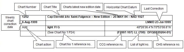
The last correction number is identified with the LNM/D or Last Notice to Mariners Number / Date. This number is expressed in either old notice number format (ex.: 594/99) or in day-month-year format which is the date known as the weekly chart correction date shown in the above diagram as item (8).
MONTHLY EDITION OF NOTICES TO MARINERS
WEB ACCESS
We are offering a feature where subscribers to our on-line service are able to receive the complete electronic monthly edition of
our Notices to Mariners. We are encouraging our clients to visit the web site to subscribe for this service:
http://www.notmar.gc.ca/subscribe/
Users wishing to receive information updates for their charts can do so by setting up a ’User Profile’ on the following web page http://www.notmar.gc.ca/search/mycharts-eng.php?czoxOToibnRtPXN0ZXBfb25lJmxhbmc9ZSI7
This feature permits users to register the nautical charts they currently have in their possession. Registrants are then automatically notified by e-mail when a Notice to Mariners is published concerning these charts.
ADVISORY
NOTICES TO SHIPPING (WRITTEN AND BROADCAST)
The Canadian Coast Guard is implementing a number of changes to the aids to navigation system in Canada.
These changes are advertised as Notices to Shipping (Broadcast and Written) by the Canadian Coast Guard and are followed up with Notices to Mariners, then charts are updated by hand correction, reprints or new editions.
Mariners are advised that all relevant Written Notices to Shipping should be kept until superseded by Notices to Mariners or through revised charts issued by the Canadian Hydrographic Service.
Written Notices to Shipping are available on the Canadian Coast Guard Website at: www.ccg-gcc.gc.ca/eng/CCG/NOTSHIP.
The Canadian Hydrographic Service is reviewing the impact of these changes with the Canadian Coast Guard and together we are preparing an action plan on the issuing of chart revisions.
For further information contact your local Regional Notices to Shipping (NOTSHIP) issuing authorities.
|
Newfoundland *Fisheries and Oceans Canada Canadian Coast Guard Port aux Basques MCTS Centre 49 Stadium Road P.O. Box 99 PORT AUX BASQUES, NL A0M 1C0 Telephone : (709) 695-2168 Facsimile : (709) 695-7784 Email :notshippax@dfo-mpo.gc.ca Website: www.ccg-gcc.gc.ca/e0030407 |
Maritimes *Fisheries and Oceans Canada Canadian Coast Guard Sydney MCTS Centre 1190 Westmount Road SYDNEY, N.S, B1R 2J6 Telephone: (902) 564-7751 or 1-800-686-8676 Facsimile: (902) 564-2446 Email :notshipssyd@mar.dfo-mpo.gc.ca Website: www.ccg-gcc.gc.ca/e0030406 |
|
Quèbec *Fisheries and Oceans Canada Canadian Coast Guard Les Escoumins MCTS Centre 5 Otis street, LES ESCOUMINS, QC G0T 1K0 Telephone: (418) 233-2308 Facsimile: (418) 233-3299 Email :Opsavis@dfo-mpo.gc.ca Websites :www.marinfo.gc.ca; www.marinfo.gc.ca/en/avisecrits/index.asp; http://www.ccg-gcc.gc.ca/eng/CCG/Notship_Home |
Central & Arctic *Fisheries and Oceans Canada Canadian Coast Guard Marine Communications and Traffic Services Notices to Shipping Series "C" 401 King Street West PRESCOTT, ON K0E 1T0 Telephone (613) 925-0666 or 1-800 265 0237 Facsimile: (613) 925-4519 Email :NotshipC&A@DFO-MPO.GC.CA Website: www.ccg-cc.gc.ca/eng/CCG/Notship_Home *Fisheries and Oceans Canada Canadian Coast Guard Iqaluit MCTS Centre Notices to Shipping Series "A" and Series “H” P.O. Box 189 IQALUIT NU X0A 0H0 Telephone: (867) 979-5269 Facsimile: (867) 979-4264 Email :IQANORDREG@INNAV.GC.CA Website: www.ccg-cc.gc.ca/eng/CCG/Notship_Home |
* Services provided in English and French
INDEX
| CANADIAN HYDROGRAPHIC SERVICE - ANNOUNCEMENT REGARDING CANADIAN HYDROGRAPHIC SERVICE CHART PATCHES | 1 |
| CANADIAN HYDROGRAPHIC SERVICE - CUMULATIVE CHART CORRECTIONS | 1 |
| CANADIAN HYDROGRAPHIC SERVICE - CURRENT CHART EDITION DATES | 1 |
| CANADIAN HYDROGRAPHIC SERVICE - PRINT ON DEMAND CHARTS - CARE AND USE | 1 |
| CANADIAN HYDROGRAPHIC SERVICE - TRANSPORT CANADA NAVIGATION SAFETY – ECDIS | 2 |
| CONSOLIDATION OF MARINE COMMUNICATIONS AND TRAFFIC SERVICES (MCTS) CENTRES | 2 |
| CANADIAN COAST GUARD PUBLICATION - RADIO AIDS TO MARINE NAVIGATION (ATLANTIC, ST. LAWRENCE, GREAT LAKES, LAKE WINNIPEG AND EASTERN ARCTIC) PUBLICATION – 2014 - THE COMMERCIAL PUBLIC CORRESPONDENCE SERVICE | 2 |
| *301 CANADIAN HYDROGRAPHIC SERVICE - ELECTRONIC NAVIGATIONAL CHARTS | 3 |
| *302 CANADIAN HYDROGRAPHIC SERVICE - NAUTICAL CHARTS | 3 |
| *303 ÎLE DE LA MADELEINE – PRIVATE UNLIGHTED BUOYS REPOSITIONED OR REMOVED | 3 |
| *304 ÎLE DE LA MADELEINE – PRIVATE UNLIGHTED BUOYS MODIFIED | 3 |
| *305 ÎLE DE LA MADELEINE – PRIVATE UNLIGHTED BUOYS ESTABLISHED | 4 |
| *306 HAVRE DE GASPÉ – PRIVATE UNLIGHTED BUOYS ESTABLISHED | 4 |
| *307 SIDNEY HARBOUR – LIGHT BUOY DISCOUNTINUED | 4 |
| *308 FLINT ISLAND TO/À CAPE SMOKEY- LIGHT AND BELL BUOY DISCOUNTINUED | 4 |
| *309 TRANSPORT CANADA - SHIP SAFETY BULLETIN | 4 |
| *310(P) RED POINT TO/À GUYON ISLAND – FIXED LIGHT AID TO BE DISCONTINUED | 5 |
| *311(P) RED POINT TO/À GUYON ISLAND – FIXED LIGHT AID TO BE DISCONTINUED | 5 |
| *312 SOREL-TRACY À/TO VARENNES – FIXED PRIVATE LIGHTED AID RELOCATED AND MODIFIED | 5 |
| *313 SOREL-TRACY À/TO VARENNES – FIXED PRIVATE LIGHTED AID RELOCATED AND MODIFIED | 6 |
| *314 SOREL-TRACY À/TO VARENNES – PRIVATE LIGHT ESTABLISHED | 6 |
| *315 LAC SAINT-JEAN – MODIFIED FIXED PRIVATE AID | 6 |
| *316 LAC SAINT-JEAN – NEW PRIVATE DAYMARK ESTABLISHED | 6 |
| *317 CANADIAN COAST GUARD PUBLICATION - NEW EDITION OF THE ANNUAL EDITION OF NOTICES TO MARINERS – 2015 | 6 |
| NUMERICAL INDEX OF CANADIAN CHARTS AFFECTED. | |||||
| Chart No. | Page | Chart No. | Page | Chart No. | Page |
| 1234 | 7 | 4016 | 11 | 4617 | 14 |
| 1236 | 7 | 4022 | 11 | 4644 | 15 |
| 1310 | 7 | 4026 | 11 | 4821 | 15 |
| 1311 | 5, 6, 8 | 4045 | 11 | 4822 | 15 |
| 1429 | 8 | 4230 | 11 | 4827 | 15 |
| 1430 | 8 | 4243 | 12 | 4831 | 15 |
| 1509 | 8, 9 | 4266 | 4, 12 | 4845 | 15 |
| 1512 | 9 | 4276 | 12 | 4849 | 15 |
| 1514 | 9 | 4302 | 12 | 4865 | 16 |
| 1515 | 9 | 4367 | 4, 12 | 4921 | 16 |
| 2257 | 10 | 4374 | 5 | 4950 | 3, 4 |
| 2299 | 10 | 4396 | 12, 13 | 4957 | 3 |
| 4001 | 10 | 4416 | 4, 13, 14 | 5860 | 16 |
| 4006 | 10 | 4429 | 14 | 5861 | 17 |
| 4010 | 10 | 4448 | 14 | 6100 | 6 |
| 4013 | 10 | 4485 | 14 | 7083 | 17, 18 |
| 4015 | 11 | 4522 | 14 | 7731 | 18 |
SECTION 1
SAFETY AND GENERAL INFORMATION
CANADIAN HYDROGRAPHIC SERVICE - ANNOUNCEMENT REGARDING CANADIAN HYDROGRAPHIC SERVICE CHART PATCHES
Colour Web Patches are free to the mariner, and given the quality of many printers, should reproduce well. They will be available in real time all around the world.
CHS welcomes your feedback on this service at chsinfo@dfo-mpo.gc.ca .
CANADIAN HYDROGRAPHIC SERVICE - CUMULATIVE CHART CORRECTIONS
The cumulative Notices to Mariners corrections for charts can now be accessed at
www.notmar.gc.ca/search/notmar-eng.php .
CANADIAN HYDROGRAPHIC SERVICE - Current chart edition dates
CHART EDITIONS
The three terms described below are used to indicate the publication status of Canadian charts.
NEW CHART - "NEWCHT"
The first publication of a Canadian chart embracing an area not previously charted to the scale shown, or embracing an area different from any existing Canadian chart.
NEW EDITION - "NEWEDT"
A new issue of an existing chart containing amendments essential to navigation in addition to those issued in Notices to Mariners and making existing editions obsolete.
REPRINTS
A new issue of the current edition of a chart incorporating no amendments of navigational significance other than those
previously promulgated in Notices to Mariners. It may also contain amendments from other sources provided they
are not essential to navigation. Previous printings of the current edition remain in force.
The current chart edition dates can be accessed at
www.chs-shc.gc.ca/charts-cartes/paper-papier/index-eng.asp
CANADIAN HYDROGRAPHIC SERVICE - PRINT ON DEMAND CHARTS - CARE AND USE
Background
By providing nautical charts to the public, the goal of the Canadian Hydrographic Service (CHS) is to provide services for safe navigation in a fiscally responsible manner. As a result, CHS continues to expand its portfolio of nautical paper charts that are printed using Print On Demand (POD) technology. These charts are easily recognized by their whiter paper and the coloured logo of the Canadian Hydrographic Service. This new technology enables CHS to print charts in a more efficient manner while enhancing chart content through being able to quickly add new and important information. POD technology provides customers with up-to-date charts without the historical hand-drawn corrections or glued-on patches. Additionally, this technology eliminates out-of-stock situations which arise with the traditional printing and warehousing methods. In the event of a national emergency, CHS can respond to the appropriate authorities with best available information very quickly.
Care of Your POD Chart
CHS encourages its customers to handle the POD charts more carefully than the traditional lithographic charts. When plotting information on POD charts, use HB pencils and apply limited pressure. Testing has suggested that an Indian gum eraser is more effective than alternatives when used on the product. This eraser is also suitable for charts printed using lithographic processes.
CANADIAN HYDROGRAPHIC SERVICE - TRANSPORT CANADA NAVIGATION SAFETY - ECDIS
Mariners are advised that ECDIS may not display some isolated shoal depths when operating in "base or standard display" mode. Route planning and monitoring alarms for these shoal depths may not always be activated. To ensure safe navigation and to confirm that a planned route is clear of such dangers, mariners should visually inspect the planned route and any deviations from it using ECDIS configured to display "all data". The automated voyage planning check function should not be solely relied upon.
CONSOLIDATION OF MARINE COMMUNICATIONS AND TRAFFIC SERVICES (MCTS) CENTRES.
The Canadian Coast Guard is modernizing and consolidating its Marine Communications and Traffic
Services Centres. Clients will continue to receive the high-quality service they have come to expect.
Once complete, there will be a total of 12 MCTS Centres strategically located across the country. Additional
information pertaining to this project will be advertised to clients by all available means
Atlantic Region
Saint John (Fundy) MCTS Centre will consolidate to Halifax MCTS Centre commencing March 2015
St. John’s MCTS Centre will consolidate to Placentia MCTS Centre commencing March 2015
St. Anthony MCTS Centre will consolidate to Labrador (Goose Bay) MCTS Centre commencing August 2015
Central & Arctic Region
Thunder Bay MCTS Centre will consolidate to Sarnia MCTS Centre commencing May 2015.
Rivière-au-Renard MCTS centre will consolidate to Les Escoumins MCTS centre commencing June 2015.
The new technology will increase efficiency permitting employees to have a greater ability to focus on the safety
services they provide to mariners. Mariners are encouraged to visit the Radio Aids to Marine Navigation (RAMN)
and Notices to Mariners (NOTMAR) PART 3 on a monthly basis for updated information and potential changes to
contact information and marine broadcast schedules.
CANADIAN COAST GUARD PUBLICATION - RADIO AIDS TO MARINE NAVIGATION (ATLANTIC, ST. LAWRENCE, GREAT LAKES, LAKE WINNIPEG AND EASTERN ARCTIC) PUBLICATION - 2013 - The Commercial Public Correspondence Service.
Part I - Page 1 of 10
ADVANCE NOTICES
The Commercial Public Correspondence Service
Effective January 1, 2014, the following changes to the Canadian Coast Guard commercial public correspondence service, provided through select Marine Communications and Traffic Services centres, will be in effect: All long distance ship-shore calls will be administered through the regular telephone service provider as acollect call. Individuals intending to placeshore-ship calls will be required to direct-dial the appropriate MCTS centre. MCTS centres providing a commercial public correspondence service are identified in RAMN, Part 2.
*301 CANADIAN HYDROGRAPHIC SERVICE - ELECTRONIC NAVIGATIONAL CHART
| NEW PRODUCTS | |
| S-57 ENC NUMBER | CHART TITLE |
| CA473457 | Slidre Fiord Beaching Area |
| CA473458 | Slidre Fiord |
| CA473460 | Resolute Passage |
| CA576464 | Caribou Harbour |
| CA576465 | Caribou Ferry Terminal/Terminal du traversier |
| CA576466 | Wood Islands Ferry Terminal/Terminal du traversier |
*302 CANADIAN HYDROGRAPHIC SERVICE - NAUTICAL CHARTS
| CHARTS | MAIN TITLE | SCALE | PUBLISHED | CAT# | PRICE |
| New Editions | |||||
| 4957 | Havre-Aubert | 1:10000 | 02-JAN-2015 | 1 | 12.00 |
*303 ÎLE DE LA MADELEINE – PRIVATE UNLIGHTED BUOYS REPOSITIONED OR REMOVED.
Reference Chart: 4950
The following aids have been repositioned:
NE corner. Lagune Havre-aux-maisons.
Yellow cautionary buoy 11746.0 from 47°25 58.5N 61°49 39.2W to 47°25 58.0N 61°49 39.0W
SE corner. Lagune Havre-aux-maisons.
Yellow cautionary buoy 11747.0 from 47°25’ 55.7’’N 61°49’ 47.4’’W to 47°25’ 55.0’’N 61°49’ 47.0’’W
(Q2015-003,004)
The following aids have been removed:
SW corner. Lagune Havre-aux-maisons. Yellow cautionary buoy 11748.0 47°25’ 58.7’’N 61°50’ 00.6’’W
NW corner. Lagune Havre-aux-maisons. Yellow cautionary buoy 11749.0 47°26’ 02.4’’N 61°49’ 56.2’’W
(Q2015-001,002)
*304 ÎLE DE LA MADELEINE – PRIVATE UNLIGHTED BUOYS MODIFIED.
Reference Chart: 4950
The following aids have been modified:
Lagune Havre-aux-maisons.
Yellow cautionary buoy 11518.0 47° 25’ 17.6‘’N 61° 50’ 05.9’’W Type changed from spar to balloon.
Lagune Havre-aux-maisons.
Yellow cautionary buoy 11519.0 47° 26’ 00.6’’N 61° 48’ 55.9’’W Type changed from spar to balloon.
(Q2015-014,015)
*305 ÎLE DE LA MADELEINE – PRIVATE UNLIGHTED BUOYS ESTABLISHED.
Reference Chart: 4950
The following aids have been established:
Lagune Havre-aux-maisons. Yellow cautionary balloon buoy 12668.0 47° 26’ 06.2‘’N 61° 49’ 03.3’’W
Lagune Havre-aux-maisons. Yellow cautionary balloon buoy 12669.0 47° 25’ 30.0’’N 61° 50’ 01.7’’W
(Q2015-008,007)
*306 HAVRE DE GASPÉ – PRIVATE UNLIGHTED BUOYS ESTABLISHED.
Reference Chart: 4416
The following aids have been established:
Bassin nord ouest – Havre de Gaspé Yellow cautionary balloon buoy 12673.0 48° 50’ 29.9‘’N 64° 28’ 14.3’’W
Bassin nord ouest – Havre de Gaspé Yellow cautionary balloon buoy 12674.0 48° 50’ 23.9‘’N 64° 28’ 20.3’’W
Bassin nord ouest – Havre de Gaspé Yellow cautionary balloon buoy 12675.0 48° 50’ 21.2‘’N 64° 28’ 13.7’’W
Bassin nord ouest – Havre de Gaspé Yellow cautionary balloon buoy 12676.0 48° 50’ 18.5‘’N 64° 28’ 07.0’’W
Bassin nord ouest – Havre de Gaspé Yellow cautionary balloon buoy 12677.0 48° 50’ 21.1‘’N 64° 27’ 59.7’’W
Bassin nord ouest – Havre de Gaspé Yellow cautionary balloon buoy 12678.0 48° 50’ 23.6’N 64° 27’ 52.5’’W
(Q2015-017, 018,019,020,021,022)
*307 SIDNEY HARBOUR – LIGHT BUOY DISCOUNTINUED
Reference: Notice 420(P)/2014 is now cancelled. (Chart 4266)
*308 FLINT ISLAND TO/À CAPE SMOKEY- LIGHT AND BELL BUOY DISCOUNTINUED
Reference: Notice 508(P)/2014 is now cancelled. (Chart 4367)
*309 TRANSPORT CANADA - SHIP SAFETY BULLETIN
This is to notify you that a new Ship Safety Bulletin has recently been posted to the Transport
Canada website at http://www.tc.gc.ca/ssb-bsn/.
To go online to view or download the bulletin, please click on the links below:
SSB#02/2015 – Why you must document how you install, secure and seal movable bulkheads to ensure their grain tightness:
RDIMS#10063548
Note: Sign yourself up for e-Bulletin to receive an e-mail notice each time a new Ship Safety Bulletin is published
on our Website.
Contact us at marinesafety-securitemaritime@tc.gc.ca or 1-855-859-3123 (Toll Free)
(G2014-219)
*310(P) RED POINT TO/À GUYON ISLAND – FIXED LIGHT AID TO BE DISCONTINUED.
Reference Chart: 4374
The Canadian Coast Guard proposes to permanently discontinue the following Aid to navigation:
Fourchu Harbour - front range LL 748 (45°43' 09".62N 60° 14' 41".99W)
Comments on this action are solicited from mariners and other interested parties.
Comments should be directed to the following within three months from the date of this notice:
Surintendant intérimaire,
Aides à la navigation et Voies navigables,
Garde côtière canadienne,
Boîte postale 5667,
St. John’s, T-N,
A1C 5X1
Téléphone: 709-772-5195
Courriel: claire.maclaren@dfo-mpo.gc.ca.
Any objections raised must state the facts on which they are based and should include supporting information on safety, commerce and public benefit.
(G2015-004)
*311(P) RED POINT TO/À GUYON ISLAND – FIXED LIGHT AID TO BE DISCONTINUED.
Reference Chart: 4374
The Canadian Coast Guard proposes to permanently discontinue the following Aid to navigation:
Fourchu Harbour - rear range LL 749 (45° 43' 07".767N 60° 14' 51".747W)
Comments on this action are solicited from mariners and other interested parties.
Comments should be directed to the following within three months from the date of this notice:
Surintendant intérimaire,
Aides à la navigation et Voies navigables,
Garde côtière canadienne,
Boîte postale 5667,
St. John’s, T-N,
A1C 5X1
Téléphone: 709-772-5195
Courriel: claire.maclaren@dfo-mpo.gc.ca.
Any objections raised must state the facts on which they are based and should include supporting information on safety, commerce and public benefit.
(G2015-005)
*312 SOREL-TRACY À/TO VARENNES – FIXED PRIVATE LIGHTED AID RELOCATED AND MODIFIED.
Reference Chart: 1311
The following aid has been relocated and the light characteristics modified to Fl 4s Yellow
Parc nautique de Contrecœur LL 11721 (45° 51’ 42.08’’N 073° 14’ 7.9’’W)
(Q2015-036)
*313 SOREL-TRACY À/TO VARENNES – FIXED PRIVATE LIGHTED AID RELOCATED AND MODIFIED.
Reference Chart: 1311
The following aid has been relocated and the light characteristics modified to Fl 4s Yellow
Parc nautique de Contrecœur LL 11722 (45° 51’ 39.23’’N 073° 14’ 13.63’’W)
(Q2015-036)
*314 SOREL-TRACY À/TO VARENNES – PRIVATE LIGHT ESTABLISHED .
Reference Chart: 1311
The following aid has been established:
Parc nautique de Contrecœur LL 12679 (45° 51’ 38.7’’N 073° 14’ 12.89’’W)
(Q2015-027,037)
*315 LAC SAINT-JEAN – MODIFIED FIXED PRIVATE AID .
Reference Chart: 6100
The following aid has been modified to Yellow:
St-Prime Brise-lame LL 6823.64 (45° 51’ 42.08’’N 073° 14’ 7.9’’W)
(Q2015-038)
*316 LAC SAINT-JEAN – NEW PRIVATE DAYMARK ESTABLISHED .
Reference Chart: 6100
The following aid has been established:
Saint-Henri-de-Taillon LL 12680 (48° 38’ 37.2163’’N 071° 49’ 18.2352’’W)
(Q2015-036)
*317 CANADIAN COAST GUARD PUBLICATION - NEW EDITION OF THE ANNUAL EDITION OF NOTICES TO MARINERS – 2015.
The 2015 edition of the Annual Edition of Notices to Mariners publication is now available for download,
free of charge, on the NOTMAR web site at
http://www.notmar.gc.ca/go.php?doc=eng/services/annual/default-eng .
Paper copies of the publication will no longer be sold.
Amendments to this publication are advertised in the Section 1 of the monthly edition of Notices to Mariners
http://www.notmar.gc.ca.
The 2015 edition has been revised up to Edition 12, 2014 and supersedes the 2014 edition.
CHART CORRECTIONS
| 1234 - Port de Pointe-au-Pic - New Edition - 04-NOV-2011 - NAD 1983 | |||
| 06-MAR-2015 | LNM/D. 04-JUL-2014 | ||
| Delete | depth of 3 metres 9 decimetres (See Chart No. 1, I10) This notice affects Electronic Navigational Chart: CA579032 |
47°37′24.3″N 070°08′22.4″W | |
| DFO(6409075-01) | |||
| Add | depth of 3 metres 4 decimetres (See Chart No. 1, I10) This notice affects Electronic Navigational Chart: CA579032 |
47°37′24.3″N 070°08′22.5″W | |
| DFO(6409075-02) | |||
| Add | depth of 4 metres 0 decimetres (See Chart No. 1, I10) This notice affects Electronic Navigational Chart: CA579032 |
47°37′23.0″N 070°08′22.9″W | |
| DFO(6409075-03) | |||
| 1236 - Pointe des Monts aux/to Escoumins - New Edition - 26-OCT-2012 - NAD 1983 | |||
| 27-MAR-2015 | LNM/D. 26-DEC-2014 | ||
| Amend | Fl 6s24m8M to read Fl 6s24m7M against light (See Chart No. 1, P16) This notice affects Electronic Navigational Chart: CA279037 |
48°49′14.3″N 068°52′33.3″W | |
| (Q2015010) LL(1729) DFO(6409061-01) | |||
| 1310 - Section A-B - New Edition - 10-JAN-2014 - NAD 1983 | |||
| 20-MAR-2015 | LNM/D. 27-FEB-2015 | ||
| Delete | private light F G, marked (Priv) (See Chart No. 1, P1) This notice affects Electronic Navigational Chart: CA579001 |
45°42′10.8″N 073°29′08.1″W | |
| (Q2014104) LL(11996.6) DFO(6409042-01) | |||
| Replace | private yellow cautionary lighted pillar buoy Fl Y, marked Priv with private yellow cautionary spar buoy, marked Priv (See Chart No. 1, Qm) This notice affects Electronic Navigational Chart: CA479155, CA579001 |
45°42′52.5″N 073°25′59.3″W | |
| (Q2014107) DFO(6409045-01) | |||
| Delete | private red starboard hand barrel buoy, marked MO2 (See Chart No. 1, Qf) This notice affects Electronic Navigational Chart: CA579001 |
45°39′22.9″N 073°29′12.2″W | |
| (Q2015028) DFO(6409080-01) | |||
| Delete | private red starboard hand barrel buoy, marked MO4 (See Chart No. 1, Qf) This notice affects Electronic Navigational Chart: CA579001 |
45°39′13.4″N 073°29′10.4″W | |
| (Q2015029) DFO(6409081-01) | |||
| 1311 - Sorel-Tracy à/to Varennes - New Edition - 19-SEP-2013 - NAD 1983 | |||
| 20-MAR-2015 | LNM/D. 13-FEB-2015 | ||
| Replace | private yellow cautionary lighted pillar buoy Fl Y, marked Priv with private yellow cautionary spar buoy, marked Priv (See Chart No. 1, Qm) This notice affects Electronic Navigational Chart: CA479155, CA579001 |
45°42′52.5″N 073°25′59.3″W | |
| (Q2014107) DFO(6409045-01) | |||
| Amend | F Y(Priv) to read 2Fl Y(Priv) against light (See Chart No. 1, P16) This notice affects Electronic Navigational Chart: CA479155 |
45°51′41.9″N 073°14′08.1″W | |
| (Q2015023-Q2015025) LL(11720-11721) DFO(6409074-01) | |||
| Amend | (Priv)F Y to read (Priv)2Fl Y against light (See Chart No. 1, P16) This notice affects Electronic Navigational Chart: CA479155 |
45°51′39.0″N 073°14′12.5″W | |
| (Q2015026-Q2015027) LL(11722-12679) DFO(6409074-02) | |||
| Delete | private light F Y (Priv) (See Chart No. 1, P1) This notice affects Electronic Navigational Chart: CA479155 |
45°51′40.4″N 073°14′10.8″W | |
| DFO(6409074-03) | |||
| 1429 - Canal de la Rive Sud - New Chart - 09-APR-2010 - NAD 1983 | |||
| 27-MAR-2015 | LNM/D. 09-AUG-2013 | ||
| Add | fixed bridge under construction (2013) (See Chart No. 1, D20.1, F32) This notice affects Electronic Navigational Chart: CA579227 |
between 45°28′23.3″N 073°32′53.4″W and 45°28′17.6″N 073°32′46.6″W |
|
| DFO(6408988-01) | |||
| 1430 - Entrée du canal Lachine - New Chart - 16-APR-2010 - NAD 1983 | |||
| 27-MAR-2015 | LNM/D. 16-JAN-2015 | ||
| Add | private yellow cautionary can buoy, marked Priv (See Chart No. 1, Qm) This notice affects Electronic Navigational Chart: CA579227 |
45°25′55.9″N 073°41′09.7″W | |
| (Q2015005) DFO(6409059-01) | |||
| Add | private white and orange control lighted can buoy Fl Y, marked Priv (See Chart No. 1, Qo) This notice affects Electronic Navigational Chart: CA579227 |
45°25′53.5″N 073°41′41.4″W | |
| (Q2015009) LL(12667) DFO(6409060-01) | |||
| 1509 - Pont-Viau à/to Île Bourdon E-F - Sheet/Feuille 2 - New Edition - 19-APR-2013 - NAD 1983 | |||
| 20-MAR-2015 | LNM/D. 17-OCT-2014 | ||
| Delete | private light F R, marked (Priv) (See Chart No. 1, P1) This notice affects Electronic Navigational Chart: CA579180 |
45°42′12.0″N 073°29′08.2″W | |
| (Q2014103) LL(11996.5) DFO(6409041-01) | |||
| Delete | private light F G, marked (Priv) (See Chart No. 1, P1) This notice affects Electronic Navigational Chart: CA579001 |
45°42′10.8″N 073°29′08.1″W | |
| (Q2014104) LL(11996.6) DFO(6409042-01) | |||
| 1509 - Île Haynes - Sheet/Feuille 2 - New Edition - 19-APR-2013 - NAD 1983 | |||
| 20-MAR-2015 | LNM/D. 17-OCT-2014 | ||
| Delete | private light F R, marked (Priv) (See Chart No. 1, P1) This notice affects Electronic Navigational Chart: CA579180 |
45°42′12.0″N 073°29′08.2″W | |
| (Q2014103) LL(11996.5) DFO(6409041-01) | |||
| Delete | private light F G, marked (Priv) (See Chart No. 1, P1) This notice affects Electronic Navigational Chart: CA579001 |
45°42′10.8″N 073°29′08.1″W | |
| (Q2014104) LL(11996.6) DFO(6409042-01) | |||
| 1512 - Ottawa Locks/Écluses 1-8 - Sheet/Feuille 1 - New Edition - 04-MAR-2005 - NAD 1983 | |||
| 06-MAR-2015 | LNM/D. 10-JAN-2014 | ||
| Add | outfall pipe (See Chart No. 1, L41.1) |
between 45°25′36.1″N 075°41′57.8″W and 45°25′39.4″N 075°42′03.4″W |
|
| DFO(6408990-02) | |||
| 1512 - Ottawa to/à Long Island - Sheet/Feuille 1 - New Edition - 04-MAR-2005 - NAD 1983 | |||
| 06-MAR-2015 | LNM/D. 10-JAN-2014 | ||
| Add | outfall pipe (See Chart No. 1, L41.1) |
between 45°25′40.6″N 075°42′23.2″W and 45°25′40.3″N 075°42′20.3″W |
|
| DFO(6408990-01) | |||
| Add | outfall pipe (See Chart No. 1, L41.1) |
between 45°25′36.1″N 075°41′57.8″W and 45°25′39.4″N 075°42′03.4″W |
|
| DFO(6408990-02) | |||
| 1514 - L'Orignal à/to Papineauville - Sheet/Feuille 2 - New Chart - 24-JUL-1998 - NAD 1983 | |||
| 06-MAR-2015 | LNM/D. 23-JAN-2015 | ||
| Delete | depth of 2 metres 7 decimetres (See Chart No. 1, I10) |
45°37′03.9″N 074°59′25.3″W | |
| DFO(6409016-01) | |||
| Add | Stump (See Chart No. 1, K43.2) |
45°37′03.2″N 074°59′25.2″W | |
| DFO(6409016-02) | |||
| Add | Stump (See Chart No. 1, K43.2) |
45°36′53.5″N 074°59′18.5″W | |
| DFO(6409016-03) | |||
| 1515 - Becketts Creek à/to Ottawa - Sheet/Feuille 2 - New Chart - 24-JUL-1998 - NAD 1983 | |||
| 06-MAR-2015 | LNM/D. 27-FEB-2015 | ||
| Delete | outfall pipe (See Chart No. 1, L41.1) |
between 45°25′40.6″N 075°42′23.2″W and 45°25′40.3″N 075°42′20.3″W |
|
| DFO(6408990-01) | |||
| 1515 - Hull - Ottawa CONTINUATION A - Sheet/Feuille 2 - New Chart - 24-JUL-1998 - NAD 1983 | |||
| 06-MAR-2015 | LNM/D. 27-FEB-2015 | ||
| Add | outfall pipe (See Chart No. 1, L41.1) |
between 45°25′40.6″N 075°42′23.2″W and 45°25′40.3″N 075°42′20.3″W |
|
| DFO(6408990-01) | |||
| 2257 - Clapperton Island to/à John Island - New Edition - 11-JAN-2002 - NAD 1983 | |||
| 27-MAR-2015 | LNM/D. 26-SEP-2014 | ||
| Delete | depth of 9 feet (See Chart No. 1, I10) This notice affects Electronic Navigational Chart: CA473251 |
46°08′45.8″N 082°16′05.6″W | |
| DFO(6604086-01) | |||
| Add | rock awash at chart datum (See Chart No. 1, K12) This notice affects Electronic Navigational Chart: CA473251 |
46°08′45.8″N 082°16′05.6″W | |
| DFO(6604086-02) | |||
| 2299 - Clapperton Island to/à Meldrum Bay - New Edition - 25-MAY-2001 - NAD 1983 | |||
| 27-MAR-2015 | LNM/D. 27-FEB-2015 | ||
| Delete | depth of 9 feet (See Chart No. 1, I10) This notice affects Electronic Navigational Chart: CA473251 |
46°08′45.8″N 082°16′05.6″W | |
| DFO(6604086-01) | |||
| Add | rock with known depth of 1 foot, dangerous to surface navigation (See Chart No. 1, K14) This notice affects Electronic Navigational Chart: CA473251 |
46°08′45.8″N 082°16′05.6″W | |
| DFO(6604086-02) | |||
| 4001 - Gulf of Maine to Strait of Belle Isle /au Detroit de Belle Isle - New Edition - 01-DEC-1995 - NAD 1983 | |||
| 06-MAR-2015 | LNM/D. 27-FEB-2015 | ||
| Add | private yellow ODAS/SADO lighted pillar FlY, Priv (See Chart No. 1, Q58) |
39°56′09.5″N 070°52′43.3″W | |
| DFO(6307048-01) | |||
| 4006 - Newfoundland and Labrador/Terre-Neuve-and-Labrador to Bermuda / aux Bermudes – New Edition - 08-AUG-2003 - NAD 1983 | |||
| 06-MAR-2015 | LNM/D. 27-FEB-2015 | ||
| Add | private yellow ODAS/SADO lighted pillar FlY, Priv (See Chart No. 1, Q58) |
39°56′09.5″N 070°52′43.3″W | |
| DFO(6307048-01) | |||
| 4010 - Bay of Fundy / Baie de Fundy (Inner portion / partie intérieure) - New Edition - 14-FEB-2003 - NAD 1983 | |||
| 27-MAR-2015 | LNM/D. 09-JAN-2015 | ||
| Delete | light OcG (See Chart No. 1, P1) This notice affects Electronic Navigational Chart: CA476006 |
44°40′33.6″N 065°45′12.5″W | |
| (F2015003) LL(203) DFO(6307062-01) | |||
| 4013 - Halifax to/à Sydney - New Edition - 06-SEP-2002 - NAD 1983 | |||
| 27-MAR-2015 | LNM/D. 27-FEB-2015 | ||
| Delete | red and white fairway lighted pillar buoy Mo(A) (See Chart No. 1, Qh) This notice affects Electronic Navigational Chart: CA276271, CA376093 |
46°18′24.2″N 060°07′50.6″W | |
| (G2015009) LL(776) DFO(6307072-01) | |||
| 4015 - Sydney to/à Saint-Pierre - New Edition - 28-MAR-2003 - NAD 1983 | |||
| 27-MAR-2015 | LNM/D. 20-FEB-2015 | ||
| Delete | red and white fairway lighted pillar buoy Mo(A) (See Chart No. 1, Qh) This notice affects Electronic Navigational Chart: CA276271, CA376093 |
46°18′24.2″N 060°07′50.6″W | |
| (G2015009) LL(776) DFO(6307072-01) | |||
| 4016 - Saint-Pierre to/à St. John's - New Edition - 06-JUN-2003 - NAD 1983 | |||
| 27-MAR-2015 | LNM/D. 06-FEB-2015 | ||
| Delete | light Fl (See Chart No. 1, P1) This notice affects Electronic Navigational Chart: CA276274, CA376316 |
47°34′42.0″N 055°07′05.0″W | |
| (N2015008) LL(115) DFO(6307061-01) | |||
| 27-MAR-2015 | LNM/D. 20-MAR-2015 | ||
| Delete | light Fl (See Chart No. 1, P1) This notice affects Electronic Navigational Chart: CA276274, CA476479 |
47°31′25.0″N 056°07′26.0″W | |
| (N2015013) LL(128.5) DFO(6307075-01) | |||
| 4022 - Cabot Strait and approaches / Détroit de Cabot and les approches, Scatarie Island to/à Anticosti Island / Île D'Anticosti - New Edition - 17-JAN-2003 - NAD 1983 | |||
| 27-MAR-2015 | LNM/D. 20-FEB-2015 | ||
| Delete | red and white fairway lighted pillar buoy Mo(A) (See Chart No. 1, Qh) This notice affects Electronic Navigational Chart: CA276271, CA376093 |
46°18′24.2″N 060°07′50.6″W | |
| (G2015009) LL(776) DFO(6307072-01) | |||
| 4026 - Havre Saint-Pierre and/and Cap des Rosiers à/to Pointe des Monts - New Edition - 23-MAY-2014 - NAD 1983 | |||
| 27-MAR-2015 | LNM/D. 22-AUG-2014 | ||
| Reposition | yellow ODAS/SADO lighted pillar Fl(5) Y 20s,
marked MLS 45138 (See Chart No. 1, Q58) This notice affects Electronic Navigational Chart: CA279044 |
from 49°32′35.9″N 065°45′35.0″W to 49°32′20.8″N 065°42′38.5″W |
|
| (Q2014037) LL(1654) DFO(6408950-01) | |||
| 4045 - Sable Island Bank/Banc de I'Île de Sable to/au St. Pierre Bank/Banc de Saint Pierre – New Edition - 10-OCT-2003 - NAD 1983 | |||
| 27-MAR-2015 | LNM/D. 27-FEB-2015 | ||
| Delete | red and white fairway lighted pillar buoy Mo(A) (See Chart No. 1, Qh) This notice affects Electronic Navigational Chart: CA276271, CA376093 |
46°18′24.2″N 060°07′50.6″W | |
| (G2015009) LL(776) DFO(6307072-01) | |||
| 4230 - Little Hope Island to/à Cape St Marys - New Chart - 15-JUN-1990 - NAD 1983 | |||
| 27-MAR-2015 | LNM/D. 10-OCT-2014 | ||
| Add | light FlR (See Chart No. 1, P1) This notice affects Electronic Navigational Chart: CA376018 |
43°59′09.6″N 066°09′39.6″W | |
| (F2015005) LL(250.1) DFO(6307066-01) | |||
| 4243 - Tusket Islands to/à Cape St. Marys - New Edition - 11-OCT-2002 - NAD 1983 | |||
| 27-MAR-2015 | LNM/D. 10-OCT-2014 | ||
| Add | light FlR (See Chart No. 1, P1) This notice affects Electronic Navigational Chart: CA376018 |
43°59′09.6″N 066°09′39.6″W | |
| (F2015005) LL(250.1) DFO(6307066-01) | |||
| 4266 - Sydney Harbour - New Edition - 28-FEB-2014 - NAD 1983 | |||
| 27-MAR-2015 | LNM/D. 05-SEP-2014 | ||
| Delete | red starboard hand lighted pillar buoy FlR, marked S8 (See Chart No. 1, Qf) This notice affects Electronic Navigational Chart: CA576095 |
46°11′29.0″N 060°13′31.0″W | |
| (G2015007) LL(781) DFO(6307067-01) | |||
| 4276 - Little Bras D'Or Continuation B-C - New Edition - 25-JUL-1997 - NAD 1983 | |||
| 27-MAR-2015 | LNM/D. 24-JAN-1997 | ||
| Add | overhead cable with vertical clearance of 18 metres (See Chart No. 1, D27) |
between 46°15′33.7″N 060°17′56.6″W and 46°15′31.3″N 060°17′46.2″W |
|
| DFO(6307069-01) | |||
| Delete | overhead cable with vertical clearance of 17 metres (See Chart No. 1, D27) |
between 46°15′24.8″N 060°17′50.2″W and 46°15′24.5″N 060°17′39.3″W |
|
| DFO(6307069-02) | |||
| 4302 - Point Tupper to Ship Point - New Chart - 28-SEP-2012 - Wgs84 | |||
| 20-MAR-2015 | LNM/D. 07-FEB-2014 | ||
| Replace | depth of 8 metres, 8 decimetres with depth of 9 metres, 3 decimetres (See Chart No. 1, I10) This notice affects Electronic Navigational Chart: CA576680 |
45°35′43.7″N 061°21′48.6″W | |
| DFO(6307074-01) | |||
| 4367 - Flint Island to/à Cape Smokey - New Edition - 03-APR-2003 - NAD 1983 | |||
| 27-MAR-2015 | LNM/D. 20-FEB-2015 | ||
| Delete | red and white fairway lighted pillar buoy Mo(A), marked SA (See Chart No. 1, Qh) This notice affects Electronic Navigational Chart: CA276271, CA376093 |
46°18′24.2″N 060°07′50.6″W | |
| (G2015009) LL(776) DFO(6307072-01) | |||
| 4396 - Annapolis Basin - New Edition - 16-JUL-2004 - NAD 1983 | |||
| 06-MAR-2015 | LNM/D. 27-FEB-2015 | ||
| Delete | drying height of 2 metres, 3 decimetres (See Chart No. 1, I15) This notice affects Electronic Navigational Chart: CA476006, CA576008 |
44°37′35.6″N 065°45′07.0″W | |
| DFO(6307051-03) | |||
| Add | breakwater, Bkw (See Chart No. 1, F4.1) This notice affects Electronic Navigational Chart: CA476006, CA576008 |
joining 44°37′36.9″N 065°45′13.9″W 44°37′35.7″N 065°45′05.2″W and 44°37′33.0″N 065°45′02.1″W |
|
| DFO(6307051-04) | |||
| Add | light FlR (See Chart No. 1, P1) This notice affects Electronic Navigational Chart: CA476006, CA576008 |
44°37′33.0″N 065°45′02.1″W | |
| (F2015001) LL(206.2) DFO(6307051-05) | |||
| 27-MAR-2015 | LNM/D. 06-MAR-2015 | ||
| Delete | light OcG10s16m8M (See Chart No. 1, P1) This notice affects Electronic Navigational Chart: CA476006 |
44°40′33.6″N 065°45′12.5″W | |
| (F2015003) LL(203) DFO(6307062-01) | |||
| 4396 - Digby - New Edition - 16-JUL-2004 - NAD 1983 | |||
| 06-MAR-2015 | LNM/D. 27-FEB-2015 | ||
| Delete | depth of 7 metres, 2 decimetres (See Chart No. 1, I10) This notice affects Electronic Navigational Chart: CA576008 |
44°37′34.2″N 065°45′03.2″W | |
| DFO(6307051-01) | |||
| Delete | depth of 1 metres, 2 decimetres (See Chart No. 1, I10) This notice affects Electronic Navigational Chart: CA576008 |
44°37′35.4″N 065°45′04.4″W | |
| DFO(6307051-02) | |||
| Delete | drying height of 2 metres, 3 decimetres (See Chart No. 1, I15) This notice affects Electronic Navigational Chart: CA476006, CA576008 |
44°37′35.6″N 065°45′07.0″W | |
| DFO(6307051-03) | |||
| Add | breakwater, Bkw, (See Chart No. 1, F4.1) This notice affects Electronic Navigational Chart: CA476006, CA576008 |
joining 44°37′36.9″N 065°45′13.9″W 44°37′35.7″N 065°45′05.2″W and 44°37′32.5″N 065°45′01.5″W |
|
| DFO(6307051-04) | |||
| Add | light FlR (See Chart No. 1, P1) This notice affects Electronic Navigational Chart: CA476006, CA576008 |
44°37′33.0″N 065°45′02.1″W | |
| (F2015001) LL(206.2) DFO(6307051-05) | |||
| Replace | depth of 7 metres, 9 decimetres with depth of 5 metres, 7 decimetres (See Chart No. 1, I10) This notice affects Electronic Navigational Chart: CA576008 |
44°37′35.8″N 065°45′03.0″W | |
| DFO(6307051-06) | |||
| 4416 - Havre de Gaspé - New Edition - 12-JUN-2009 - NAD 1983 | |||
| 20-MAR-2015 | LNM/D. 21-NOV-2014 | ||
| Add | private green port hand can buoy, marquée Priv (See Chart No. 1, Qg) This notice affects Electronic Navigational Chart: CA379086, CA579089 |
48°50′26.2″N 064°27′45.2″W | |
| (Q2015011) DFO(6409062-01) | |||
| Add | private green port hand can buoy, marquée Priv (See Chart No. 1, Qg) This notice affects Electronic Navigational Chart: CA379086, CA579089 |
48°50′31.0″N 064°27′56.8″W | |
| (Q2015012) DFO(6409063-01) | |||
| Add | private green port hand can buoy, marquée Priv (See Chart No. 1, Qg) This notice affects Electronic Navigational Chart: CA379086, CA579089 |
48°50′35.9″N 064°28′08.3″W | |
| (Q2015013) DFO(6409064-01) | |||
| 4429 - Havre Saint-Pierre – New Edition - 18-FEV-2011 - NAD 1983 | |||
| 27-MAR-2015 | LNM/D. 22-FEB-2013 | ||
| Affix | patch Download patch - http://www.chs-shc.gc.ca/patches/pa4429-20150224.pdf This notice affects Electronic Navigational Chart: CA579004 |
50°14′10.0″N 063°36′36.0″W | |
| DFO(6409017-01) | |||
| 4448 - Mabou Harbour - New Edition - 13-DEC-2002 - NAD 1983 | |||
| 13-MAR-2015 | LNM/D. 21-NOV-2014 | ||
| Affix | patch Download patch - http://www.chs-shc.gc.ca/patches/4448PA_20150204.pdf |
46°05′18.0″N 061°28′30.0″W | |
| DFO(6307057-01) | |||
| 4485 - Cap des Rosiers à/to Chandler - New Edition - 17-JUN-2011 - NAD 1983 | |||
| 20-MAR-2015 | LNM/D. 05-APR-2013 | ||
| Delete | marine farm (See Chart No. 1, K48.2) This notice affects Electronic Navigational Chart: CA379086 |
48°23′15.9″N 064°28′16.5″W | |
| DFO(6409036-01) | |||
| 4522 - Approaches to La Scie Harbour - New Edition - 10-OCT-2003 - NAD 1983 | |||
| 27-MAR-2015 | LNM/D. 21-NOV-2014 | ||
| Delete | light Fl6s80ft (See Chart No. 1, P1) This notice affects Electronic Navigational Chart: CA376656 |
49°58′16.2″N 055°36′30.4″W | |
| (N2015009) LL(266) DFO(6307063-01) | |||
| 4522 - La Scie Harbour - New Edition - 10-OCT-2003 - NAD 1983 | |||
| 27-MAR-2015 | LNM/D. 21-NOV-2014 | ||
| Delete | light Fl6s80ft (See Chart No. 1, P1) This notice affects Electronic Navigational Chart: CA376656 |
49°58′15.8″N 055°36′30.9″W | |
| (N2015009) LL(266) DFO(6307063-01) | |||
| 4617 - Long Harbour, Erco Wharf - New Edition - 30-APR-2010 - NAD 1983 | |||
| 06-MAR-2015 | LNM/D. 14-FEB-2014 | ||
| Affix | patch Download patch - http://www.chs-shc.gc.ca/patches/4617PA_20150120.pdf |
47°25′30.0″N 053°49′30.0″W | |
| DFO(6307052-01) | |||
| 4644 - Bay D'Espoir and/and Hermitage Bay - New Edition - 25-JUN-1999 - NAD 1983 | |||
| 27-MAR-2015 | LNM/D. 26-DEC-2014 | ||
| Delete | light Fl (See Chart No. 1, P1) This notice affects Electronic Navigational Chart: CA276274, CA476479 |
47°31′28.1″N 056°07′32.1″W | |
| (N2015013) LL(128.5) DFO(6307075-01) | |||
| 4821 - White Bay and/and Notre Dame Bay - New Chart - 23-APR-2004 - NAD 1983 | |||
| 27-MAR-2015 | LNM/D. 12-DEC-2014 | ||
| Delete | light Fl6s24m7M (See Chart No. 1, P1) This notice affects Electronic Navigational Chart: CA376656 |
49°58′15.8″N 055°36′30.8″W | |
| (N2015009) LL(266) DFO(6307063-01) | |||
| 4822 - Cape St. John to/à St. Anthony - New Chart - 30-JUN-2006 - NAD 1983 | |||
| 27-MAR-2015 | LNM/D. 02-NOV-2012 | ||
| Delete | light Fl6s24m7M (See Chart No. 1, P1) This notice affects Electronic Navigational Chart: CA376656 |
49°58′15.8″N 055°36′30.8″W | |
| (N2015009) LL(266) DFO(6307063-01) | |||
| 4827 - Hare Bay to/à Fortune Head - New Chart - 13-AUG-2004 - NAD 1983 | |||
| 27-MAR-2015 | LNM/D. 13-FEB-2015 | ||
| Delete | light Fl (See Chart No. 1, P1) This notice affects Electronic Navigational Chart: CA276274, CA476479 |
47°31′28.0″N 056°07′32.0″W | |
| (N2015013) LL(128.5) DFO(6307075-01) | |||
| 4831 - Fortune Bay - Northern Portion/Partie Nord – New Chart - 26-DEC-1986 - NAD 1983 | |||
| 20-MAR-2015 | LNM/D. 10-JAN-2014 | ||
| Delete | light Fl6s50m (See Chart No. 1, P1) This notice affects Electronic Navigational Chart: CA276274, CA376316 |
47°34′42.0″N 055°07′05.0″W | |
| (N2015008) LL(115) DFO(6307061-01) | |||
| 4845 - Lumley Cove - New Edition - 12-SEP-1997 - NAD 1983 | |||
| 13-MAR-2015 | LNM/D. 23-AUG-2013 | ||
| Reposition | red starboard hand lighted spar buoy FlR, marked MF6 (See Chart No. 1, Qf) This notice affects Electronic Navigational Chart: CA576072 |
from 46°58′15.0″N 052°56′44.5″W to 46°58′15.5″N 052°56′43.8″W |
|
| (N2015004) LL(511.23) DFO(6307056-01) | |||
| 4849 - Catalina Harbour - New Chart - 30-DEC-1988 - NAD 1983 | |||
| 27-MAR-2015 | LNM/D. 10-FEB-2015 | ||
| Amend | FlG to read QG against green port hand pillar light buoy, marked TC11 (See Chart No. 1, Qg) This notice affects Electronic Navigational Chart: CA576395 |
48°30′51.1″N 053°04′18.1″W | |
| (N2015011) LL(460) DFO(6307070-01) | |||
| 4865 - Approaches to/Approches à Lewisporte and/and Loon Bay - New Edition - 27-MAY-2005 - NAD 1983 | |||
| 13-MAR-2015 | LNM/D. 31-DEC-2010 | ||
| Amend | FlR(Priv) to read FlY(Priv) against light (See Chart No. 1, P65) This notice affects Electronic Navigational Chart: CA476168, CA576169 |
49°14′56.2″N 055°02′57.5″W | |
| (N2015007) LL(353.6) DFO(6307059-03) | |||
| 4865 - Lewisporte - New Edition - 27-MAY-2005 - NAD 1983 | |||
| 13-MAR-2015 | LNM/D. 31-DEC-2010 | ||
| Amend | FlR(Priv) to read FlY(Priv) against light (See Chart No. 1, P65) This notice affects Electronic Navigational Chart: CA576169 |
49°14′55.4″N 055°02′57.5″W | |
| (N2015006) LL(353.7) DFO(6307059-01) | |||
| Delete | private light FlR(Priv) (See Chart No. 1, P65) This notice affects Electronic Navigational Chart: CA576169 |
49°14′54.7″N 055°02′57.4″W | |
| (N2015005) LL(353.4) DFO(6307059-02) | |||
| Amend | FlR(Priv) to read FlY(Priv) against light (See Chart No. 1, P65) This notice affects Electronic Navigational Chart: CA476168, CA576169 |
49°14′56.2″N 055°02′57.5″W | |
| (N2015007) LL(353.6) DFO(6307059-03) | |||
| 4921 - Paspébiac - New Edition - 16-MAR-2012 - NAD 1983 | |||
| 06-MAR-2015 | LNM/D. 13-FEB-2015 | ||
| Delete | marine farm limits (See Chart No. 1, K48.1) This notice affects Electronic Navigational Chart: CA479073 |
joining 47°59′37.7″N 065°18′00.0″W 48°00′04.6″N 065°16′38.3″W 48°00′25.6″N 065°16′54.8″W 47°59′59.8″N 065°18′15.4″W and 47°59′37.7″N 065°18′00.0″W |
|
| DFO(6409021-01) | |||
| Add | marine farm (See Chart No. 1, K48.2) This notice affects Electronic Navigational Chart: CA479073 |
48°00′03.1″N 065°17′56.4″W | |
| DFO(6409021-02) | |||
| 5860 - Approaches to/Approches à Moose River - New Edition - 27-MAY-2005 - NAD 1983 | |||
| 27-MAR-2015 | |||
| Delete | red starboard hand lighted spar buoy FlR, marked M2 (See Chart No. 1, Qf) |
51°25′05.5″N 080°18′18.0″W | |
| (A2012020) LL(INL 2626) DFO(6604090-02) | |||
| Delete | green port hand spar buoy, marked M7 (See Chart No. 1, Qg) |
51°19′44.5″N 080°26′47.0″W | |
| (A2012024) LL(INL 2628.001) DFO(6604090-06) | |||
| Delete | red starboard hand spar buoy, marked M8 (See Chart No. 1, Qf) |
51°19′17.0″N 080°29′08.5″W | |
| (A2012025) LL(INL 2628.003) DFO(6604090-07) | |||
| 5861 - Ship Sands Island to/à Moosonee - New Edition - 27-MAY-2005 - NAD 1983 | |||
| 27-MAR-2015 | |||
| Delete | light, Fl (See Chart No. 1, P1) |
51°15′30.0″N 080°38′08.0″W | |
| (A2012019) LL(INL 2632) DFO(6604090-01) | |||
| Delete | red starboard hand lighted spar buoy FlR, marked M14 (See Chart No. 1, Qf) |
51°16′39.5″N 080°37′26.5″W | |
| (A2012021) LL(INL 2629) DFO(6604090-03) | |||
| Delete | red starboard hand lighted spar buoy FlR, marked M16 (See Chart No. 1, Qf) |
51°16′01.5″N 080°37′47.5″W | |
| (A2012022) LL(INL 2630) DFO(6604090-04) | |||
| Delete | green port hand lighted spar buoy FlG, marked M17 (See Chart No. 1, Qg) |
51°16′01.5″N 080°37′43.5″W | |
| (A2012023) LL(INL 2631) DFO(6604090-05) | |||
| Delete | green port hand spar buoy, marked M7 (See Chart No. 1, Qg) |
51°19′44.5″N 080°26′47.0″W | |
| (A2012024) LL(INL 2628.001) DFO(6604090-06) | |||
| Delete | red starboard hand spar buoy, marked M8 (See Chart No. 1, Qf) |
51°19′17.0″N 080°29′08.5″W | |
| (A2012025) LL(INL 2628.003) DFO(6604090-07) | |||
| Delete | red starboard hand spar buoy, marked M10 (See Chart No. 1, Qf) |
51°18′36.0″N 080°32′04.5″W | |
| (A2012026) LL(INL 2628.007) DFO(6604090-08) | |||
| Delete | green port hand spar buoy, marked M9 (See Chart No. 1, Qg) |
51°18′32.0″N 080°31′22.0″W | |
| (A2012027) LL(INL 2628.005) DFO(6604090-09) | |||
| 7083 - Cambridge Bay to/à Shepherd Bay - New Edition - 15-JUN-1984 - Inconnu | |||
| 27-MAR-2015 | LNM/D. 27-SEP-2013 | ||
| Delete | depth of 11 fathoms 0 feet (See Chart No. 1, I10) |
68°09′00.0″N 098°54′00.0″W | |
| DFO(6604084-01) | |||
| Add | depth of 5 fathoms 0 feet (See Chart No. 1, I10) |
68°09′00.0″N 098°54′00.0″W | |
| DFO(6604084-02) | |||
| Add | depth of 1 fathom 5 feet (See Chart No. 1, I10) |
68°22′30.0″N 099°19′18.0″W | |
| DFO(6604085-01) | |||
| Add | depth of 1 fathom 4 feet (See Chart No. 1, I10) |
68°13′42.0″N 099°04′00.0″W | |
| DFO(6604085-02) | |||
| Add | depth of 1 fathom 4 feet (See Chart No. 1, I10) |
68°13′18.0″N 099°06′06.0″W | |
| DFO(6604085-03) | |||
| Add | depth of 2 fathoms 4 feet (See Chart No. 1, I10) |
68°12′06.0″N 099°02′42.0″W | |
| DFO(6604085-04) | |||
| Add | depth of 5 fathoms 2 feet (See Chart No. 1, I10) |
68°11′18.0″N 098°59′36.0″W | |
| DFO(6604085-05) | |||
| Add | depth of 2 fathoms 2 feet (See Chart No. 1, I10) |
68°08′12.0″N 098°57′48.0″W | |
| DFO(6604085-06) | |||
| Add | depth of 1 fathom 4 feet (See Chart No. 1, I10) |
68°07′36.0″N 098°54′24.0″W | |
| DFO(6604085-07) | |||
| Add | depth of 1 fathom 0 feet (See Chart No. 1, I10) |
68°06′54.0″N 098°52′24.0″W | |
| DFO(6604085-08) | |||
| 7731 - Storis Passage and Approaches - New Edition - 25-MAY-1984 - Inconnu | |||
| 27-MAR-2015 | LNM/D. 23-MAY-2014 | ||
| Add | depth of 1 fathom 5 feet (See Chart No. 1, I10) |
68°22′30.0″N 099°19′18.0″W | |
| DFO(6604085-01) | |||
CORRECTIONS TO RADIO AIDS TO MARINE NAVIGATION
NO CORRECTIONS FOR THIS SECTION
SAILING DIRECTIONS AND SAMLL CRAFT GUIDE CORRECTIONS
ATL 101 — Newfoundland — Northeast and East Coasts, Second Edition, 2013 —
Chapter 1 — Paragraph 56, last line
Add: A shoal, extending about 70 m (230 ft) off the wharf with a least depth of 4.2 m (14 ft) and marked
by starboard hand light buoy KA2.2 (243.11), is located about 220 m (722 ft) SE of the NW end of the wharf.
(N2015-00.1)
Chapter 4 — Paragraph 114, last line
Add: An ODAS light buoy is moored about 0.6 mile NW of Little Gull Island.
(N2015-00.2)
Chapter 5 — Paragraph 253
Delete: “A fog signal … points 113°.”
(N2015-00.3)
Chapter 6 — Paragraph 5
Delete: “A fog signal … 191° and 341°.”
(N2015-00.4)
ATL 103 — Newfoundland — Southwest Coast, Second Edition, 2010 —
Chapter 3 — Paragraph 18, after “navigation”
Insert: and marked by port hand light buoy VG (133.1)
(N2015-00.5)
Chapter 3 — Paragraph 19, last line
Add: A fish farm is charted close off the mouth of Northwest Cove; caution is advised.
(N2015-00.6)
Chapter 3 — Paragraph 20, last line
Add: A fish farm is charted in the entrance to Olive Cove; caution is advised.
(N2015-00.7)
Chapter 3 — Paragraph 23, last line
Add: Gimlet Point is located on the west side of Little Passage, about 0.5 mile NW of The Matchums.
A shoal, with a least depth of 2.4 m (8 ft) and marked by port hand light buoy VG3 (133.3), extends about 0.1
mile NW of Gimlet Point.
(N2015-00.8)
Chapter 3 — After paragraph 25
Insert: 25.1 Two shoals, with depths of 4.9 m (16 ft) and marked by port and starboard hand light buoys
VG5 (133.5) and VG4 (133.44), are located 0.8 and
1.1 miles NNE of Little Island, respectively.
(N2015-00.9)
Chapter 3 — Paragraph 64, last line
Add: A shoal with a least depth of 0.6 m (2 ft) and marked by starboard hand light buoy VG6 (133.66) extends about
0.1 mile NW of the NW end of Riches Island.
(N2015-01.0)
Chapter 3 — Paragraph 119, last line
Add: Fish farms are charted 0.7 and 1.5 miles north of the south entrance point to Bob Lock Cove; caution is advised.
(N2015-01.1)
Chapter 5 — Paragraph 129, last line
Add: An ODAS light buoy is moored about 0.4 mile ESE of Southeast Shoal.
(N2015-01.2)
INDEX — After “Gélin, Tête Sud de, C1/P73”
Insert: Gimlet Point, C3/P23
(N2015-01.3)
ATL 108 — Gulf of St. Lawrence (Southwest Portion), First Edition, 2006 —
Chapter 4 — Paragraph 315
Delete: of a wharf and
(Q2014-038.1)
ATL 109 — Gulf of St. Lawrence (Northeast Portion), First Edition, 2006 —
Chapter 2 — Paragraph 137
Delete: , vertical clearance 27 feet (8.2 m),
(Q2015-005.1)
Chapter 4 — Paragraph 48, last line
Add: An ODAS light buoy is moored about 0.7 mile west of Man O’War Shoal.
(N2015-01.4)
Chapter 4 — Paragraph 99, after “Beach Point”
Insert: (Blue Beach)
(N2015-01.5)
Chapter 4 — Before paragraph 103, Photo caption
Delete: BLUE BEACH
Replace by: BEACH POINT (BLUE BEACH)
(N2015-01.6)
INDEX — After “Bay Shoal, 18”
Delete: Beach Point, 92, 105
Replace by: Beach Point (Blue Beach), 92
Beach Point (Codroy), 105
(N2015-01.7)
ATL 110 — St. Lawrence River — Cap Whittle/Cap Gaspé to Les Escoumins and Anticosti Island, Third Edition, 2011 —
Chapter 1 — In the vicinity of paragraph 154, Table 1.2 Havre-Saint-Pierre Wharves
Make the following changes in the “Depth” column.
| Berth | Length metres |
Depth metres |
| Public Wharf | ||
| SSW Section | 108 | 9,2 |
| NW Section | 50*** | 2,0 - 5,4 |
| Private Wharf | ||
| 244* | 10 | |
(Q2015-003.2)
Chapter 1 — Paragraph 155, after “with depths of”
Delete: 2.5 m
Replace by: 2.1 m in the entrance and between 2.5 and 2.9 m inside the basin
(Q2015-003.1)
Chapter 3 — Paragraph 89, after “Cap Colombier light (1729)”
Insert: — seasonal —
(Q2015-015.1)
ATL 111 — St. Lawrence River — Île Verte to Québec and Fjord du Saguenay, Third Edition, 2007 —
Chapter 1 — Delete paragraph 76 and the light pictograph adjacent to it.
Replace by: 76 The wharf at Cap-à-l’Aigle is backed by a breakwater on its SE side. A service floating
wharf is adjacent to the wharf, on its SE side. There is a launching ramp at the inner end of the wharf.
Cap à l’Aigle light (1840) is shown from a tower on the outer end of the breakwater (47°40'N, 70°06'W).
(Q2015-007.1)
Chapter 1 — Adjacent to paragraph 76, add wharf and light pictographs.
(Q2015-007.2)
Chapter 3 — Paragraph 91, after “knowledge is required”
Delete: “; for further … Appendix.”
Replace by: There are private beacons from the river mouth to the marina. For further
information on facilities, consult the Appendix.
(Q2015-004.1)
Chapter 3 — Paragraph 136
Delete: (2013)
Replace by: (2014)
(Q2015-009.1)
ATL 112 — St. Lawrence River — Cap-Rouge to Montréal and Rivière Richelieu, Third Edition, 2009 —
Chapter 2 — In the vicinity of paragraph 142, Table 2.3 Contrecoeur Terminal Wharves
Make the following change in the “Depth” column.
| Berth | Depth metres |
| 2 | 5,7 |
(Q2014-046.1)
Chapter 3 — After paragraph 50
Insert: 50.1 There is a prohibited anchorage area extending on either side of the Highway 20 bridge due
to a submerged oil pipeline crossing the river close downstream of the bridge.
(Q2015-008.1)
Chapter 3 — Adjacent to paragraph 50.1, add a caution pictograph.
(Q2015-008.2)
ATL 121 — Labrador, Hamilton Inlet to Cape Chidley (including Button Islands and Gray Strait), First Edition, 2004 —
Chapter 3 — Before paragraph 118
Chapter 3 — Before paragraph 120, Top left column
Delete: 4776
(N2015-01.8)
CEN 308 — Rideau Canal and Ottawa River, First Edition, 2003 —
Chapter 8 — Paragraph 12
Delete: is a sewer outfall
Replace by: are two sewer outfalls
(Q2014-051.1)
Chapter 8 — Delete paragraph 13
Replace by: 13 The Hull district public wharf is immediately downstream of Alexandra Bridge, on the
west side of the river. This irregular shaped wharf extends 120 m from shore and has a three-level landing
pier 53 m wide with depths of 2.4 m. There is a launching ramp on the north side of the wharf. Many tour boats
make a stop-over at this wharf.
(Q2014-063.1)
LIST OF LIGHTS, BUOYS AND FOG SIGNALS CORRECTIONS
Newfoundland |
||||||||||
37.51 |
Chance Rock Fairhaven - light buoy PFH3 |
47 31 43.2 053 54 06.6 |
Fl |
G |
4s |
..... |
..... |
Green spar, marked "PFH3". |
Year round. Chart:4617 Edn. 03/15 (N15-002) |
|
115 |
Long Harbour Point Light |
Delete from list. Chart:4831 Edn. 03/15 (N15-008) |
||||||||
128.5 |
Grole Point |
|
Delete from list. Chart:4644 Edn. 03/15 (N14-012) |
|||||||
152 |
Goose Island - light buoy QD3 |
Off Goose Island. 47 36 31.1 058 42 10.4 |
Fl |
G |
4s |
..... |
..... |
Green spar, marked "QD3". |
Year round. Chart:4639 Edn. 03/15 (N15-010) |
|
266 |
Sleepy Point (La Scie) |
|
Delete from list. Chart:4522 Edn. 03/15 (N15-009) |
|||||||
353.4 |
Imperial Oil East Dolphin Light |
|
Delete from list. Chart:4862 Edn. 03/15 (N15-005) |
|||||||
353.6 |
Lewisporte, outer dolphin |
On the end of breakwater. 49 14 56.3 055 02 57.5 |
Fl |
Y |
4s |
..... |
..... |
Square mast. |
Year round. Privately maintained. Chart:4865 Edn. 03/15 (N15-007) |
|
353.7 |
Lewisporte Mid-catwalk |
49 14 55.4 055 02 57.5 |
Fl |
Y |
4s |
..... |
..... |
Black cylindrical mast. |
Year round. Privately maintained. Chart:4865 Edn. 03/15 (N15-006) |
|
355.075 |
Dildo Run - light buoy DY6 |
49 31 35.5 054 41 36 |
Fl |
R |
4s |
..... |
..... |
Red spar, marked "DY6". |
Seasonal. Chart:4863 Edn. 03/15 (N15-003) |
|
393.6 |
Ladle Cove - inner light buoy JA2 |
49 28 29.6 054 03 10.2 |
Fl |
R |
4s |
..... |
..... |
Red spar, marked "JA2". |
Seasonal. Chart:4530 Edn 03/15 (N15-001) |
|
460 |
Chenal Catalina Harbour Channel- light buoy TC11 |
East of Hiscock's point. 48 30 51.4 053 04 18.1 |
Q |
G |
1s |
..... |
..... |
Green spar, marked "TC11". |
Year round. Chart:4849 Edn. 03/15 (N15-011) |
|
511.23 |
Lumley Cove - inner light buoy MF6 |
46 58 15 052 56 44.5 |
Fl |
R |
4s |
..... |
..... |
Red spar, marked "MF6". |
Year round. Chart:4845 Edn. 03/15 (N15-004) |
|
Atlantic |
||||||||||
203 H3894 |
Victoria Beach |
Delete from list. Chart:4396 Edn 03/15 (F15-003) |
||||||||
206.2 |
Digby, Breakwater light |
44 37 33.0 065 45 02.1 |
Fl |
R |
4s |
15.5 |
4 |
Pipe swing pole. 3 |
Year round. Chart:4396 Edn. 03/15 (F15-001) |
|
250.1 |
Port Maitland west breakwater light |
43 59 9.6 066 09 39.6 |
Fl |
R |
4s |
..... |
4 |
Cylindrical mast. 3.0 |
Year round. Chart:4243 Edn. 03/15(F15-005) |
|
367 H3759.4 |
Lower Jordan Bay, Wharf |
On most northernly end of wharf. 43 40 52 065 14 23 |
LFl |
W |
6s |
3 |
3 |
10’ cylindrical mast, enclosed lower portion. White and red rectangular daymark 3.8 |
Year round. Flash 2s, eclipse 4s Chart:4241 Edn. 03/15 (F14-040) |
|
659 H3474 |
White Head Island |
SW side of island. 45 11 49.1 061 08 10.8 |
Fl |
W |
5s |
18.2 |
12 |
White block, red upper portion. 10.6 |
Year round. Flash 0.5 s; eclipse 4.5 s. Emergency light discontinued. Horn - Blast 3 s; sil. 27 s. Horn points 190°. Chart:4233 Edn. 03/15 (G15-008) |
|
776 |
Sydney Harbour -light buoy SA |
Delete from list. Chart:4367 Edn. 03/15 (G15-009) |
||||||||
792 H772 793 H772.1 |
Little Bras d’Or - range |
| | | | | | | | | | | | | | | |
On N. side of entrance. 46 18 43.9 060 17 13.8 211°46’ 354 m from front. |
F F |
R R |
..... ..... |
8.8 12.7 |
6 3 |
Galvanized steel, square skeleton tower, white daymark, red vertical stripe 3.6 Triangular skeleton tower, white daymark, red vertical stripe. 6.5 |
Year round. Year round. Chart: 4276 Edn 03/15 (G14-214-215) |
1654 |
Mont-Louis - ODAS light buoy MLS 45138 |
Off Mont-Louis. 49 32 20.8 065 42 38.5 |
Fl(5) |
Y |
20s |
..... |
..... |
Yellow, marked "MLS 45138". |
Seasonal. Chart:4026 Edn. 03/15(Q14-037) |
|
1729 H2063 |
Cap Colombier FR |
On cape. 48 49 14.3 068 52 33.3 |
Fl |
W |
6s |
24.1 |
7 |
Square skeleton tower. 9.8 |
Seasonal. Flash. 1 s; eclipse. 5 s. Operates at night only. Chart:1236 Edn.03/15(Q15-010) |
|
1823.68 1823.69 |
Quartier-de-la-Chapelle - range |
| | | | | | | |
Delete from list. Delete from list. |
Chart:6100 Edn. 03/15 (Q15-034;035) |
||||||
2333.2 |
Cap St-Michel -light buoy |
45 42 52.5 073 25 59.3 |
Fl |
Y |
4s |
..... |
..... |
Yellow spar, marked "Kronos Priv". |
Year round. Privately maintained. Chart: 1310 Edn. 03/15 (Q14-106) |
|
Inland LL 2626 |
Moose River, Approach light buoy M2 |
Delete from list. Chart: 5860 Edn. 03/15 (A12-020) |
||||||||
Inland LL 2629 |
Moosonee - light buoy M14 |
Delete from list. Chart: 5861 Edn. 03/15 (A12-021) |
||||||||
Inland LL 2630 |
Charles Island - light buoy M16 |
Delete from list. Chart: 5861 Edn. 03/15 (A12-022) |
||||||||
Inland LL 2631 |
Charles Island - light buoy M17 |
Delete from list. Chart: 5861 Edn. 03/15 (A12-023) |
||||||||
Inland LL 2632 H36.8 |
Charles Island |
Delete from list. Chart: 5861 Edn. 03/15 (A12-019) |
||||||||
Inland Waters |
||||||||||
2626 |
Moose River, Approach light buoy M2 |
Delete from list. Chart: 5860 Edn. 03/15 (A12-020) |
||||||||
2629 |
Moosonee - light buoy M14 |
Delete from list. Chart: 5861 Edn. 03/15 (A12-021) |
||||||||
2630 |
Charles Island - light buoy M16 |
Delete from list. Chart: 5861 Edn. 03/15 (A12-022) |
||||||||
2631 |
Charles Island - light buoy M17 |
Delete from list. Chart: 5861 Edn. 03/15 (A12-023) |
||||||||
2632 H36.8 |
Charles Island |
Delete from list. Chart: 5861 Edn. 03/15 (A12-019) |
||||||||
|
CANADIAN COAST GUARD MARINE INFORMATION REPORT AND SUGGESTION SHEET. |
Name of Ship or Sender:..................................................................... Date:....................................
Address of Sender:..........................................................................................................................
Street # Street Name
Town / City:.............................. Prov / State:....................... Postal Code / Zip Code: ........................
Tel / Fax / E-mail address of sender (if appropriate):............................................................................
Observation Date:............................................. Time (UTC): ...........................................................
Geographical Position:......................................................................................................................
Coordinate Position: Lat: ............................................... Long:.........................................................
Position Method: q DGPS q GPS with WAAS q GPS q Radar qOther
Horizontal Datum Used: qWGS 84 q NAD 27 q Other
Estimated Position Accuracy:............................................................................................................
Chart #:............................................................ Datum: q NAD 27 q NAD 83
Chart Edition:.................................................... Last Correction applied:............................................
Publications affected: (Quote Volume and page):.................................................................................
*Full details (Attach additional sheets as necessary)............................................................................
Mariners are requested to notify the responsible authorities when new or suspected dangers to navigation are discovered, changes are observed in aids to navigation, or corrections to publications are seen to be necessary.
In the case of new or suspected dangers to navigation, it is important that all details be given in order to aid with future investigations. Items of interest include heights, depths, physical description, type of bottom and equipment method used to position the item. It is helpful to mark details on chart, which will be promptly replaced by the Canadian Hydrographic Service.
Reports should be made to the nearest Marine Communications and Traffic Services Centre (MCTS) and should be confirmed in writing to:
|
Leader, Notices to Mariners Canadian Coast Guard Department of Fisheries and Oceans Montréal, Qc H2Y 2E7 |
In the case of information concerning aids to navigation or the List of Lights, Buoys and Fog Signals. |
|
OR |
|
Dominion Hydrographer Canadian Hydrographic Service Department of Fisheries and Oceans Ottawa, Ontario, K1A 0E6 |
In the case of new or suspected dangers to navigation or where corrections to "Sailing Directions" appear to be necessary. |
Or general questions on Coast Guard programs or services please send an e-mail message to:
info@dfo-mpo.gc.ca (Please include your postal code and e-mail address).